Path planning of scenic spots based on improved A* algorithm
←
→
Page content transcription
If your browser does not render page correctly, please read the page content below
www.nature.com/scientificreports
OPEN Path planning of scenic spots based
on improved A* algorithm
Xingdong Wang1, Haowei Zhang1*, Shuo Liu1, Jialu Wang2, Yuhua Wang1 &
Donghui Shangguan3
Traditional scenic route planning only considers the shortest path, which ignores the information
of scenic road conditions. As the most effective direct search method to solve the shortest path in
static road network, A* algorithm can plan the optimal scenic route by comprehensively evaluating
the weights of each expanded node in the gridded scenic area. However, A* algorithm has the
problem of traversing more nodes and ignoring the cost of road in the route planning. In order to
bring better travel experience to the travelers, the above factors are taken into account. This paper
presents a path planning method based on the improved A* algorithm. Firstly, the heuristic function
of the A* algorithm is weighted by exponential decay to improve the calculation efficiency of the
algorithm. Secondly, in order to increase the practicality of the A* algorithm, the impact factors that
road conditions is introduced to the evaluation function. Finally, the feasibility of the improved A*
algorithm is verified through simulation experiments. Experimental results show that the improved A*
algorithm can effectively reduce the calculation time and road cost.
With the development of social economy, people’s living standards have improved significantly, and tourism
has become one of the most enthusiastic ways for people in their spare time. For tourists, the terrain of scenic
spots is often rugged, so it is essential to keep enough energy to visit them. At the same time, for scenic spots, an
efficient tour path can also reduce the congestion of scenic spots and improve the resource utilization of scenic
spots, which is conducive to the sustainable and healthy development of scenic spots1. Therefore, reasonable tour
path planning is very important to tourists’ experience.
For the optimal path solving problem, researchers have proposed many classical algorithms including dijestra
algorithm, Flow Direction algorithm2, etc. Dijkstra algorithm was proposed in 1959, and the algorithm is suit-
able for static networks, that is, when the weight in the network is fixed and there is no negative weight3. In the
improvement of the algorithm, Zhang et al. proposed a path planning method based on dijkstra, which can save
driving time and oil consumption4. Rosita et al. used vector normalization technology combined with dijkstra
algorithm to achieve the optimal distribution path of products5. Sabri et al. used the combination of dijkstra
algorithm and ant colony algorithm to find the safest escape path in high-rise b uildings6. Ant colony algorithm
was proposed by Italian scientist Dorigo according to the foraging process of animals, and the algorithm was
originally used to solve the traveling salesman p roblem7. After that, many researchers improved the algorithm,
for example, Zhou et al. optimized the intelligent logistics distribution path based on the improved ant colony
algorithm, which was better to improve the dynamic optimization performance of the algorithm8. Yu et al. com-
bined a special genetic operator in the ant colony algorithm, which not only avoids the local search limitations
of the ant colony algorithm, but also enhances the global optimal searching ability of the ant colony algorithm9.
In addition, there are many algorithms and improvements for solving the shortest path problem, such as, Miao
et al. proposed an improved adaptive ant colony algorithm. While improving the real-time and security of robot
path planning, balance the convergence and global search ability of ant colony algorithm, and transform the
path planning problem into a multi-objective optimization problem by introducing multi-objective performance
index, so as to realize the global comprehensive optimization of robot path planning10. Hsieh et al. proposed
a route planning algorithm which combines the two-way fast-exploring random tree algorithm and greedy
algorithm to generate various route planning schemes for ice navigation, and evaluated and selected a relatively
optimal route with a lower risk scheme through a risk index11. Rakita et al. proposed a new sampling-based path
planning method, which quickly finds solutions to high-dimensional path planning problems by minimizing
the number of collision check samples12. Pan et al. used the improved floyd algorithm to design the optimal
delivery path for take-out food, so that the travel time of the vehicle after optimization was shortened and the
1
College of Information Science and Engineering, Henan University of Technology, Zhengzhou 450001,
China. 2School of Resources and Environmental Engineering, Anshun University, Anshun 561000, China. 3State
Key Laboratory of Cryospheric Science, Northwest Institute of Eco‑Environment and Resources, Chinese Academy
Sciences, Lanzhou 730000, China. *email: 463182358@qq.com
Scientific Reports | (2022) 12:1320 | https://doi.org/10.1038/s41598-022-05386-6 1
Vol.:(0123456789)
www.nature.com/scientificreports/
time efficiency was improved, but the algorithm did not consider the impact of road c onditions13. Wu et al. com-
bined normal distributed random numbers with genetic algorithms, and considered traveling least costs and the
traveling highest experience index to construct the optimal tourism p ath14. Although the algorithms have been
improved for their respective problems, some of their inherent shortcomings are difficult to eradicate. As the
most effective direct search method for solving the shortest path in static road network, A* algorithm has been
improved countless. Wang et al. Introduced the turning factor into the A* algorithm to solve the K shortest path
problem. At the same time, they proposed a dynamic path planning method based on the A* algorithm, which
can effectively search the shortest path and avoid c ollision15. Liu et al. Proposed an improved A* algorithm to
solve the combination of normal channel and berthing channel16. Uttendorf et al. combined the fuzzy inference
system with the A* algorithm to generate a path map for automatically guided vehicles17. Das et al. proposed an
online path planning method based on an improved real-time A* algorithm, which plans the optimal path by
avoiding obstructions and minimizing time, energy, and distance as the c ost18. Shin et al. proposed an improved
A* algorithm using Automatic Identification System (AIS) and weather data, and it finds the optimal paths by
minimizing the estimated time of arrival generated by machine learning through 16-way node exploration19.
Alani et al. proposed a new technique that consists of a hybridizing of A* algorithm and ant colony optimiza-
tion, and the new technology can more accurately find the best parking path20. Pradhan et al. and Pardines both
proposed to implement shopping guide path recommendations based on consumers’ shopping lists, but they
did not consider the problem of supermarket space m odeling21,22. Ma et al. proposed a navigation path planning
method for articulated underground scrapers based on improved A* algorithm to improve search e fficiency23.
Rahul et al. solved the problem of robotic path planning using a combination of A* algorithm and Fuzzy Infer-
ence, which finds the shortest path and generates the result in a finite time24.
In the above path planning study, there are many Dijkstra methods and swarm intelligence algorithms.
Although the algorithms have been improved for their own problems, the inefficiency of the Dijkstra algorithm
itself and the problem of the ant colony algorithm which is sensitive to the algorithm parameters are difficult to
solve. In addition, the improvement of A* algorithm still has the problem of ignoring road cost. In order to pro-
vide better scenic route planning for passengers, this paper presents a route planning method based on improved
A* algorithm. By exponentially weighting the heuristic function of the A* algorithm, the calculation efficiency of
the algorithm is improved, and the A* algorithm is improved by using the road condition information of scenic
spots as the evaluation index, which makes the algorithm more applicable to the actual scenic spot route planning.
A* algorithm
The A* algorithm combines the advantages of the dijkstra algorithm and the breadth first search algorithm, which
has better performance in the search25,26. The basic idea of the algorithm is as follows: First, find all neighbor
nodes of the current search node. Second, compute the evaluation function value of each neighboring node,
and the evaluation function in path planning is the distance from the initial node S to the goal node G. Finally,
select the node which has the minimum evaluation function. The above process is repeated until the search
reaches the end point.
The evaluation function of each node n is defined as follows:
f(n) = g(n) + h(n) (1)
where f(n) denotes the estimated path cost from S to G, g(n) denotes the actual path cost from S to the cur-
rent node, and h(n) is the heuristic function which denotes the estimated path cost from the current node to G.
The heuristic function is generally expressed as Manhattan distance, Diagonal distance, or Euclidean distance.
The traditional A* algorithm has the problem that search nodes are too many and calculation time is too
long. And heuristic function h(n) has an important influence on the speed and accuracy of path planning. Only
by choosing a suitable h(n) value can we get the optimal path. To solve the problem, this paper improves the
calculation efficiency of the A* algorithm by weighting the heuristic function. Besides, in order to increase the
practicality, the impact factors (road conditions) are introduced to the evaluation function.
Improvement of A* algorithm
Exponential weighting in the heuristic function. In extreme cases, when the heuristic function
h(n) = 0, the priority of nodes will be determined by g(n), then the algorithm degenerates to dijkstra algorithm.
If h(n) is always less than or equal to the cost from the current node to G, then A* algorithm guarantees that it
can find the shortest path. But the smaller h(n) is, the more A* algorithm will traverse nodes, which will lead to
the slower search. Therefore, the weighting of h(n) in the heuristic function should be increased. The exponential
attenuation method was proposed for weighting by Wang et al. as shown in Eq. (2), and the improved search
efficiency is further improved27.
(2)
f(n) = g(n) + exp [h(n)] ∗ h(n) + h p
where h(p) is the distance from the parent node of current node to the target node. exp[h(n)] is the weighting
of the heuristic function.
Improvement of valuation function. It not only needs to quickly plan paths for tourists, but also needs
to consider the road ups and downs in scenic areas to provide the best route for tourists to save time and effort.
In this paper, the path planning for scenic spots is improved on the basis of Eq. (2). And the valuation function
of A* algorithm needs to be modified accordingly. g(n) in the traditional A* algorithm is the total distance from
Scientific Reports | (2022) 12:1320 | https://doi.org/10.1038/s41598-022-05386-6 2
Vol:.(1234567890)
www.nature.com/scientificreports/
the starting node S to the current node n. This paper introduces one impact factors (road condition level p(n))
to the evaluation function, The improved g(n) is as follows:
m
g(n) = p(n) (3)
i=1
where m represents the number of road sections passed from the starting node S to the current node n. p(n)
can be set as linear functions f(x) = ax + b, where x represents the actual distance of the r oad28. For terrain with
different road conditions, the terrain undulation can be set to r, and a can be calculated according to the calcula-
tion function (The calculation function is a = c*r + d). This paper set r = 30°, 45°, 60°; c = 0.2, d = 1, b = 1, and we
can get Eq. (4) as follows:
fp (x) = (0.2r + 1)x + 1 (4)
From the above Equation (3), (4), we can obtain the Equation (5) as follows
m
g(n) = (0.2r + 1)x + 1 (5)
i=1
The heuristic function h(n) can be set by exponential weighting according to Eq. (3) and Eq. (6). The evalu-
ation function of the improved A* algorithm can be expressed as follows:
m
f(n) = (0.2r + 1)x + 1 + exp [h(n)] ∗ h(n) + h p (6)
i=1
This paper uses two lists (Open list and Close list) to store the relevant node information. The Open list mainly
saves the node information that has been generated but has not been accessed, while the Close list mainly saves
the visited node information. The fake code for he improved A* algorithm is listed as follows:
The flow chart of the improved A* algorithm is shown in Fig. 1.
Results
Process of path planning. First, introduce the road condition level to construct a dynamic road network
data model for scenic spots. Then, the heuristic function is improved by exponential weighting. Finally, the start
and end points of path planning are determined, and the improved A* algorithm is used for path planning. The
path planning process is shown in Fig. 2:
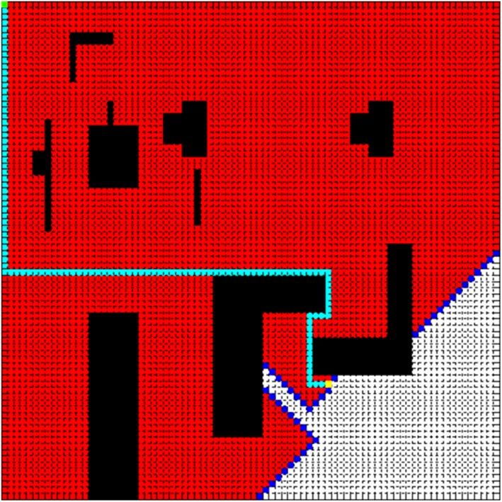
Simulation experiments. The side length of the square is 80 in Fig. 3, and it is divided into 80 × 80 grids.
The simulation experiment of the path planning is done by MATLAB R2010b shown in Fig. 3 in the simulation
map. Take the top left corner of the simulation map as the origin of the coordinates, and the start point is set to
(1, 1) represented by a green point, and the end point is set to (62, 53) represented by a yellow point. Pink poly-
gons indicate that road undulation angle is larger than 30°, and black polygons represent obstacles.
In order to verify the feasibility of the improved A* algorithm, we add dijkstra algorithm, A* algorithm for
comparison and evaluate the optimization effect from three aspects: Number Of Nodes Traversed (NONT),
Path Cost (PC), and Path Length (PL). Figures 4, 5 and 6 compare the effect of path planning, and Table 1 is the
parameters comparison.
In Figs. 4, 5 and 6, the red area is the node area to be traversed by the algorithm, and the blue is the boundary
of the traversed area, and the cyan is the path, and the purple is the area with a slope greater than 30.
The results presented in Table 1 shows that the improved A* algorithm can effectively reduce the calculation
time and road cost. Compared to the traditional A* algorithm, although the improved A* algorithm increased
the path length by 30.2%, it reduced the number of nodes traversed and path cost by 86.8% and 30.3% respec-
tively. Compared to the dijkstra algorithm, it reduced the number of nodes traversed and path cost by 91.8%
and 30.3% respectively.
Discussion and conclusion
In order to solve the problem that the A* algorithm ignores the road cost in path planning, this paper proposes
a path planning method based on improved A* algorithm. Firstly, the heuristic function of the A* algorithm is
weighted to improve the calculation efficiency. Secondly, in order to increase the practicality, the impact factors
(road conditions) is introduced to the evaluation function. The feasibility of the improved A* algorithm is veri-
fied by comparing with dijkstra algorithm and traditional A* algorithms. Experimental results show that the
improved A* algorithm can effectively reduce the calculation time and road cost.
Compared to the traditional A* algorithm and dijkstra algorithm, the improved A* algorithm achieves
remarkable results, and it is more suitable for the path planning of Scenic spots. It can be seen that dijkstra algo-
rithm and traditional A* algorithm both traverse a lot of nodes and ignore the road cost on finding the optimal
path. Besides, as can be clearly seen from the Table 1, the number of traversed nodes decreases from 4631 to 381
nodes, on the other hand, the path cost decreases from 115 to 94. The improved A* algorithm is slightly stronger
in real time and practicality.
In the simulation experiments, we assume that the environment is completely known, that is, obstacles, road
conditions, start point and end point are custom-designed, so the simulation environment can’t represent all
Scientific Reports | (2022) 12:1320 | https://doi.org/10.1038/s41598-022-05386-6 3
Vol.:(0123456789)
www.nature.com/scientificreports/

                                                                Add the starting point to the Open List
                                                                                                          Y
                                                                               Open==null
                                                                                     N
                                                                   Select the node with the smallest             Path not
                                                                            f(n) in Open list                     found

                                                                                  Find the         Y
                                                        Y                       target node
                                                                                   N                   Trace back along the
                                                                        Add the current node            parent of the target
                                                                           to Close list                       node
                                                Neighbor                 Processing neighbor                                      End
                                                                  N
                                              node has been              nodes of the current
                                                traversed                       node

                                                                                Neighbor                           N
                                                                             node is reachable
                                                                                       Y
                                                                              Neighbor node                        Y
                                                                               in Close list
                                                                                       N
                                                                                                                   Y
                                                                      Neighbor node in Open list
                                                                                     N                        f(n) of the node     N
                                                                         Check a new node ,                   becomes smaller
                                                                      process the f(n),g(n), and
                                                                        h(n) of the node, set                          Y
                                                                        parent as the current           Update the f(n) of this
                                                                       node, and add the new            node and set parent to
                                                                          node to Open list               the current node

                                            Figure 1.  Flow chart of improved A* algorithm.

                                                    Set virtual simulation
                                                        environment

                                                    The impact factors are
                                                     introduced to set the
                                                       weighting of grid

                                             Improve the heuristic function
                                             through exponential weighting

                                              Set start node and end node,
                                                 and use improved A*
                                                 algorithm to plan path

                                                    Get the optimal path

                                            Figure 2.  Flow chart of path planning.

          Scientific Reports |   (2022) 12:1320 |                  https://doi.org/10.1038/s41598-022-05386-6                           4

Vol:.(1234567890)
www.nature.com/scientificreports/
Figure 3. Simulation map.
Figure 4. Dijkstra algorithm.
Figure 5. A* algorithm.
Scientific Reports | (2022) 12:1320 | https://doi.org/10.1038/s41598-022-05386-6 5
Vol.:(0123456789)www.nature.com/scientificreports/
Figure 6. Improved A* algorithm.
Algorithm NONT PC PL
Dijkstra 4631 135 119
A* 2871 135 119
Improved A* 380 94 155
Table 1. Parameter comparision.
the scenic environment. Accordingly, path planning research in unknown environments may be the next step
of our research.
Moreover, impact factors, such as road conditions and the popularity of scenic spots, have not been statisti-
cally examined at present due to the difficulty in measuring and establishing the simulation environment of
scenic spots. Terrain undulation is set to 30°, 45°, 60° and the popularity of scenic spots is set to 1, 1.5, 2 in this
paper. However, there are a great many factors influencing path planning, and we only selectively discussed some
common factors due to the restriction of data. Other factors, such as path’s congestion, tourism emergency, move
speed of tourists, are not included. This will be a focus of future research, and it should take different mode of
dividing according to different scenic spots.
Compared to the dijkstra algorithm and traditional A* algorithm, although the improved A* algorithm
reduced the number of nodes traversed and path cost effectively, the path length increased from 119 to 155.
Therefore, it is suggested that the future work should be focused on reducing the path length of improved A*
algorithm.
Data availability
The data that support the findings of this study are available from the corresponding author upon reasonable
request.
Received: 7 October 2021; Accepted: 11 January 2022
References
1. Gavalas, D., Kasapakis, V., Pantziou, G., Konstantopoulos, C. & Zaroliagis, C. Scenic athens: A personalized scenic route planner
for tourists. In 2016 IEEE Symposium on Computers and Communication (2016).
2. Karami, H., Anaraki, M. V., Farzin, S. & Mirjalili, S. Flow direction algorithm (FDA): A novel optimizer approach for solving
optimization problems. Comput. Ind. Eng. 156(4), 107224 (2021).
3. Zhang, D., Li, G., Zheng, K., Ming, X. C. & Pan, Z. H. An energy-balanced routing method based on forward-aware factor for
wireless sensor networks. IEEE Trans. Ind. Inf. 10, 766–773 (2014).
4. Zhang, J. D. et al. Vehicle routing in urban areas based on the oil consumption Weight-Dijkstra algorithm. IET Intell. Transp. Syst.
10, 495–502 (2016).
5. Rosita, Y. D., Rosyida, E. E. & Rudiyanto, M. A. Implementation of Dijkstra algorithm and multi-criteria decision-making for
optimal route distribution. Procedia Comput. Sci. 161, 378–385 (2019).
6. Mohd Sabri, N. A., Hasan Basari, A. S., Hussin, B. & Abu Samah, K. A. F. Dijkstra-Ant colony optimization algorithm for shortest
and safest evacuation in high rise building. J. Teknol. 79, 69–77 (2017).
7. Dorigo, M., Maniezzo, V. & Colorni, A. Ant system: Optimization by a colony of cooperating agents. IEEE Trans. Syst. Man. Cybern.
Part B IEEE Trans. Cybern. 26, 29–41 (1996).
8. Zhou, X. C., Yang, T. T., Liu, X. F. & Pan, Y. H. Intelligent logistics delivery path optimization method based on improved ant
colony algorithm. J. Inner Mong. Norm. Univ. (Natl. Sci. Edn.). 46, 888–892 (2017).
Scientific Reports | (2022) 12:1320 | https://doi.org/10.1038/s41598-022-05386-6 6
Vol:.(1234567890)www.nature.com/scientificreports/
9. Yu, Y. & Szeto, K. Y. Minimize the average mean first passage time of random walk in complex networks by genetic algorithm. In
2016 IEEE Congress on Evolutionary Computation (2016).
10. Miao, C. W., Chen, G. Z., Yan, C. L. & Wu, L. L. Path planning optimization of indoor mobile robot based on adaptive ant colony
algorithm. Comput. Ind. Eng. 156, 107230 (2021).
11. Hsieh, T. H., Wang, S. Z., Gong, H. J., Liu, W. & Xu, N. Sea ice warning visualization and path planning for ice navigation based
on radar image recognition. J. Mar. Sci. Tech. Taiw. 29, 277–286 (2021).
12. Rakita, D., Mutlu, B. & Gleicher, M. Single-query path planning using sample-efficient probability informed trees. IEEE Robot.
Autom. Let. 6, 4624–4631 (2021).
13. Pan, F. Q. et al. Optimal route design for vehicle driving based on open blocks. J. Shenzhen Univ. (Sci. Eng.). 37, 143–150 (2020).
14. Wu, P., Zhu, J. M. & Zhu, L. B. Research on tourism route design based on multi-objective planning and intelligent optimization
algorithm. Math. Pract. Theory 46, 105–114 (2016).
15. Wang, S. S., Cai, Z. L. & Ren, F. An optimal path algorithm based on weighted hierarchical road network. Sci. Surv. Map. 40,
127–131 (2015).
16. Liu, C. G., Mao, Q. Z., Chu, X. M. & Xie, S. An improved A-star algorithm considering water current, traffic separation and berth-
ing for vessel path planning. Appl. Sci. 9, 1057 (2019).
17. Uttendorf, S., Eilert, B. & Overmeyer, L. Combining a fuzzy inference system with an A* algorithm for the automated generation
of roadmaps for Automated Guided Vehicles. Automatisierungstechnik 65, 189–197 (2017).
18. Das, P. K., Behera, H. S., Pradhan, S. K., Tripathy, H. K. & Jena, P. K. A Modified real time A* algorithm and its performance
analysis for improved path planning of mobile robot. Comput. Intell. Data Min. 32, 221–234 (2015).
19. Shin, Y. W. et al. Near-optimal weather routing by using improved A* algorithm. Appl Sci. 10, 6010 (2020).
20. Alani, S., Baseel, A., Hamdi, M. M. & Rashid, S. A. A hybrid technique for single-source shortest path-based on A* algorithm and
ant colony optimization. IJ-AI 9, 256–263 (2020).
21. Pradhan, S., Krishna, P. R. & Rout, S. S. Wish-list based shopping path discovery and profitable path recommendations services
in emerging markets. In 2012 Third International Conference on. IEEE Computer Society (2012).
22. Pardines, I. & Lopez, V. Shop&Go: TSP heuristics for an optimal shopping with smartphones. Sci. China Inf. Sci. 56, 1–12 (2013).
23. Ma, F., Yang, H., Gu, Q. & Meng, Y. Navigation path planning of unmanned underground LHD based on improved A* algorithm.
Trans. Chin. Soc. Agric. Eng. 46, 303–309 (2015).
24. Rahul, K., Anupam, S. & Ritu, T. Fusion of probabilistic A* algorithm and fuzzy inference system for robotic path planning. Artif.
Intell. Rev. 33, 275–306 (2010).
25. Pal, A., Tiwari, R. & Shukla, A. Modified A* Algorithm for Mobile Robot Path Planning Vol. 395, 183–193 (Springer, Berlin, 2012).
26. Guruji, A. K., Agarwal, H. & Parsediya, D. K. Time-efficient A* Algorithm for robot path planning. Procedia Technol. 23, 144–149
(2016).
27. Wang, W., Pei, D. & Feng, Z. The shortest path planning for mobile robots using improved A* algorithm. J. Comput. Appl. 38,
1523–1526 (2018).
28. Wang, C., et al. Path planning of automated guided vehicles based on improved A-Star algorithm. In IEEE International Conference
on Information & Automation. 2071–2076 (2015).
Author contributions
X.W. completed the results and the manuscript. H.Z. completed the data collection and the implementation of
the algorithm. S.L. completed the programming of the algorithm. J.W., Y.W. and D.S. completed the correction
of the paper.
Funding
This research was supported in part by the Key Scientific Research Project in Colleges and Universities of Henan
Province of China under Grant 22A420004, in part by the Science and Technology Cooperation Project of
Anshun University under Grant (LH[2017]7059), in part by the Cultivation Programme for Young Backbone
Teachers in Henan University of Technology under Grant 21420070, and in part by the Key Projects of Science
and Technology Research of Henan Province under Grant 202102310334.
Competing interests
The authors declare no competing interests.
Additional information
Correspondence and requests for materials should be addressed to H.Z.
Reprints and permissions information is available at www.nature.com/reprints.
Publisher’s note Springer Nature remains neutral with regard to jurisdictional claims in published maps and
institutional affiliations.
Open Access This article is licensed under a Creative Commons Attribution 4.0 International
License, which permits use, sharing, adaptation, distribution and reproduction in any medium or
format, as long as you give appropriate credit to the original author(s) and the source, provide a link to the
Creative Commons licence, and indicate if changes were made. The images or other third party material in this
article are included in the article’s Creative Commons licence, unless indicated otherwise in a credit line to the
material. If material is not included in the article’s Creative Commons licence and your intended use is not
permitted by statutory regulation or exceeds the permitted use, you will need to obtain permission directly from
the copyright holder. To view a copy of this licence, visit http://creativecommons.org/licenses/by/4.0/.
© The Author(s) 2022
Scientific Reports | (2022) 12:1320 | https://doi.org/10.1038/s41598-022-05386-6 7
Vol.:(0123456789)You can also read