PAPAROA TRACK Plan and prepare - DOC
←
→
Page content transcription
If your browser does not render page correctly, please read the page content below
Plan and prepare

PAPAROA TRACK
  Duration: 3 days hiking              Great Walks season:
            2 days mountain biking     All year
  Distance 55.1 km hiking
  (one way): 56.2 km mountain biking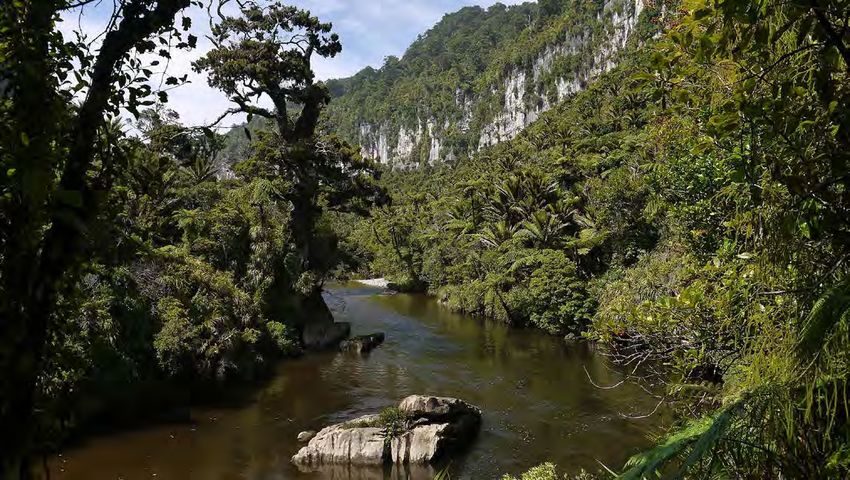
PAPAROA                                                Elevation profile & track guide
                                                                                                                                                                M

TRACK
                                             1,400 m                                                                                                            To
                                                                                                Ces Clark Hut                                                   2
                                                                                                  16 bunks
                                             1,200 m

                                             1,000 m                                                              Pike River Mine
                                                                                                                   Interpretation
 Experience our newest Great Walk             800 m                                                                    Centre
                                                       Smoke-ho                                                   Under construction,
– a purpose-built, shared-use hiking                   car park                                                   opening date to be                            T
                                              600 m                                                                                                         L
 and mountain biking track within                                                                                    confirmed.
                                                                                                                                                       IA
                                                                                                                                                    OR
 the Paparoa National Park on the             400 m                                                                                               EM
                                                                                                                                             9M
                                                                                                                                        E2
West Coast of the South Island.               200 m                                                                              PI K
This Great Walk crosses the Paparoa              0m
 Range, taking you through alpine                                  Hiking: 4 – 5 hr / 10.3 km
                                                                   Biking: 2 – 3 hr / 10.3 km
                                                                                                                    Hiking: 3 hr / 9.7 km
                                                                                                          Biking: 1 hr 30 min – 2 hr 30 min / 9.7 km
 tops, limestone karst landscapes
 and thriving rainforests.
Once completed, the Pike29
Memorial Track will lead from the
Paparoa Track to the site of the
former Pike River Mine.
The Paparoa Track provides walking and
cycling access through the remote and
spectacular wilderness of the Paparoa
National Park. The track is challenging in
poor weather. You will need a good level
of fitness and the right equipment.
                                                         Day 1: Smoke-ho car park to Moonlight Tops Hut
The track is well marked and signposted,
but some sections are steep and                             	Hiking: 7 – 8 hours, 20 km
rough, and the track may be muddy.                            Biking: 3 hr 30 min – 5 hr 30 min, 20 km
This brochure describes a 3-day hike                     The Great Walk begins at its southern end at Smoke-ho car
for independent non-guided walkers                       park near Blackball, about a 45-minute drive from Greymouth.
travelling from Smoke-ho car park to                     Beginning on the historic Croesus Track, with remnants of the
Pororari River car park.                                 area’s gold mining history, the track ascends through beech
                                                         and podocarp forest before reaching Ces Clark Hut.
There is also a 4-day hike option,
                                                         This part of the track is much rougher than the rest of the
spending the first night at Ces Clark Hut.
                                                         Paparoa Track because of its historic nature.
This is a good alternative for families.
                                                         Beyond the hut you pass through alpine scrub and tussock,
                                                         and you will be rewarded with expansive views of Grey River/
                                                         Māwheranui to the east and the Tasman Sea to the west.
                                                         Moonlight Tops Hut provides spectacular views.

     	Duration:
       3 days hiking
       2 days mountain biking

 Distance (one way):
 55.1 km hiking                               ABOVE LEFT TO RIGHT: Photo: Stewart Nimmo;
                                              Photo: Jason Blair;
 56.2 km mountain biking                      Photo: Shaun Barnett/Black Robin Photography


      Great Walks season:                     MAIN PHOTO: Photo: Stewart Nimmo
      All year
                                              COVER: Photo: Jason Blair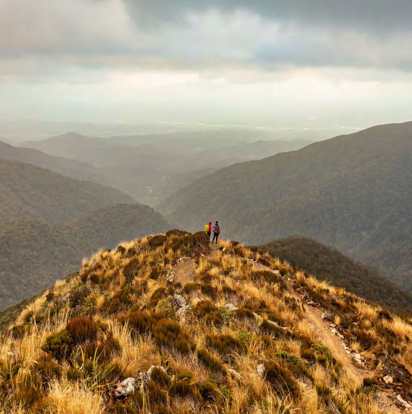
car                       interpretation
Moonlight                                                                                                         park           hut        centre
Tops Hut
20 bunks

                                                                       Pororari Hut                                                           Pororari
       CK
                                                                        20 bunks                                                                River
 T   RA   Track under                                                                                                                         car park
                                                                                                                                               (exit for   Waikori
         construction,                                                                                                                                       Road
        opening date to                                                                                                                         hikers)
                                                                                                                                                           car park
         be confirmed.                                                                                                                                      (exit for
                                                                                                                                         Inland              bikers)
                                                                                                                                       Pack Track
                                                                                                                                        junction

                                  Hiking: 5 – 7 hr / 19.1 km                                           Hiking: 4 – 5 hr / 16 km
                                  Biking: 4 – 5 hr / 19.1 km                                  Biking: 2 hr 30 min – 3 hr 30 min, 17.1 km

      Day 2: M
              oonlight Tops Hut to Pororari Hut                               Day 3: Pororari Hut to Pororari River car park

            	Hiking: 5 – 7 hours, 19.1 km                                        	Hiking: 4 – 5 hours, 16 km
              Biking: 4 – 5 hr, 19.1 km                                             Biking: 2 hr 30 min – 3 hr 30 min, 17.1 km
      On day 2, open tops give way to alpine forest stunted by the             The Paparoa Track descends and follows the upper Pororari
      harsh environment. The Paparoa Track winds along the top of              River valley, until it joins an old track built to establish
      the escarpment, with steep cliffs and stunning views. About              settlement in the upper valley. The track sidles along a
      half-way to Pororari Hut, you descend from the escarpment                spectacular gorge and descends through beech forest
      through ancient podocarp forest. The track then follows the              interspersed with northern rātā. At the junction with the
      ridge above Tindale Creek to Pororari Hut. Keep an eye out for           historic Inland Pack Track, hikers and mountain bikers
      the Lone Hand, a gnarled outcrop of rock on the north side of            diverge: hikers follow the track beside the Pororari River
      the Pororari River.                                                      through the lower gorge; mountain bikers must exit into
                                                                               the Punakaiki River valley, ending at Waikori Road car park.
                                                                               Both pass through lush rainforest with glades of nīkau palms.
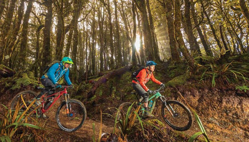
Mountain biking
Photo: Jason Blair
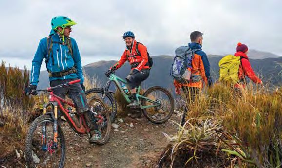
The Paparoa Track is a shared- Can I do it?
use track for hikers and mountain The Paparoa Track is a tough ride and Respect others, respect
bikers. This is the first purpose- not to be underestimated – to ride the rules, respect the track.
built, shared-use Great Walk safely you need to be fit, experienced Follow the mountain biking
constructed by the Department and have good equipment. This should rules below:
include a well-maintained mountain
of Conservation. Biking on the You are not permitted to
bike, a comprehensive bike tool kit,
track is allowed year-round. quick release chain link, spare tube/
take a mountain bike into
any hut or shelter, or onto
fresh patch kit, pump/CO2 pump,
hut porches.
cable ties and duct tape. For a list
2 days and 1 night of essential equipment, see www. Stay on the formed and
mountainsafety.org.nz/activities/ designated mountain bike
Smoke-ho car park to Moonlight Tops mountain-biking. tracks.
Hut: 20 km, 3 hr 30 min – 5 hr 30 min
Electric bikes are not
oonlight Tops Hut to Waikori Road
M
You can expect allowed on the track.
car park: 36.2 km, 6 hr 30 min – A well-formed 56.2 km track maintained
Bikers must give way
8 hr 30 min to Advanced: Grade 4 mountain biking to walkers.
Note: Once the Pike29 Memorial Track standard, with numerous swing and
suspension bridges. Night riding is not permitted.
is open, there will be route options
that include the Pike River Mine Plan to spend one night on the track.
Interpretation Centre. You are responsible for:
You will encounter changeable weather
conditions, including extremely Obeying the mountain
bikers code. The track is
cold temperatures, rain, high winds
shared with hikers and other
MTB grade: Advanced and possibly snow; steep slopes and
bikers – show respect for
(Grade 4) generally avoidable obstacles; and track
other users.
A mixture of long, steep climbs, sections that are prone to flooding.
narrow track, poor traction and Following signs and other
Refer to the ‘Know before you go’
obstacles that are difficult to markers that clearly identify
section of this brochure for more
avoid or jump over. Generally where mountain bikes can
information. be ridden and where they
exposed at the track’s outside
edge. Most riders will find some are not allowed.
sections easier to walk.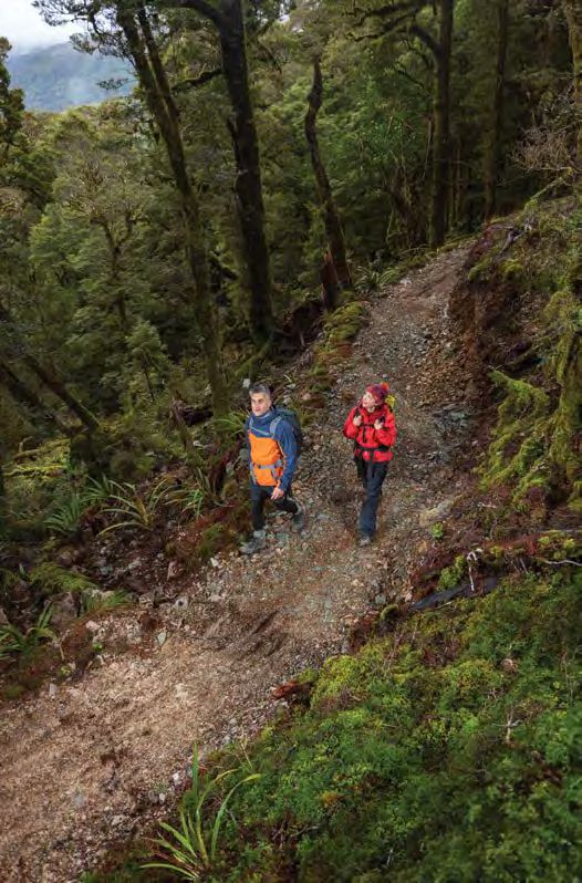
Highlights
                                                                                                                 1

                                                                                           Air New Zealand
                                                                                           partners with the
Photo: Tom Hopkins (DOC)                                                                    Department of
                                                                                         Conservation to bring

                                                        2
                                                                                           birdsong back to
                                                                                           our Great Walks.

                                                                  1   Explore the spectacular Pororari River
                                                                       Gorge, with dramatic limestone cliffs,
                                                                       beech forests and glades of subtropical
                                                                       nīkau palms.
 Photo: Stewart Nimmo (nimmophoto.co.nz)
                                                                  2    back and enjoy incredible sunsets over
                                                                      Sit

 3                                         4
                                                                      the Tasman Sea from Moonlight Tops Hut.
                                                                  3	Follow in the footsteps of gold miners on the
                                                                      historic Croesus Track. Take a side trip to
                                                                      Garden Gully to see gold-mining remains,
                                                                      including a 1930s miner’s hut and a century-
                                                                      old quartz crushing battery (45 min return).
                                                                  4    dmire the stunning waharoa at the
                                                                      A
                                                                        Paparoa Track entrances and exits. These
                                                                        waharoa were carved by a team of Ngāti
                                                                        Waewae carvers, led by Mahana Coulston.

                                                                  Conservation story
                                                                  5   The Department of Conservation works in
                                                                       partnership with Air New Zealand (DOC’s
 Photo: Baptiste Maryns                    Photo: Stewart Nimmo        National Partner for Conservation) and the
                                                                       Paparoa Wildlife Trust in the south-east

                                                        5
                                                                       ranges bordering the Paparoa National Park
                                                                       to increase the size of existing populations of
                                                                       threatened native birds. These partnerships
                                                                       enable a pest-control trapping network to be
                                                                       maintained across 15,000 hectares of land.
                                                                       This programme, in conjunction with the
                                                                       12.5-hectare pest-proof kiwi crèche on the
                                                                       Atarau plains and the Paparoa great spotted
                                                                       kiwi/roroa project, is delivering significant
 Photo: Lynne Maguire
                                                                       gains for kiwi and many other species.
                                                                       www.pwt.org.nz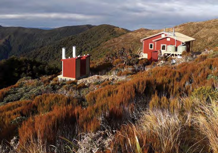
Te Miko Pororari
No public access to
!
r ee k
ck C
Fo
ll o #
!
Bu
s s il
Mount Lodge
Cave
Pike29 Memorial Track
Dil e m m
" "
1447m
!
aC
C re
Creek
Hiker re
Punakaiki c k Resurgence ek
!
Tra
ek
ENTRY/EXIT ck
"
Pa Mt Bovis Route
Mount Bovis
d
# 1252m
an
Dolomite Point
Access to the Pike29 Memorial
!
In l
Track is not possible or safe until
after the official track opening.
Punakaiki
" Mountain bike Po
ro
Marine
Paparoa
ra
ENTRY/EXIT r
Reserve
iR
E
ive
National Park
G
At the time of printing this
r
N
Waikori
A
publication, large sections of the 659m Lone Hand
R
# 947m
#
#
Pike29 Memorial Track are still
Mount Johnston
1241m
under construction. The opening
"
T ind a
le C Mount Pecksniff
r ee # 1306m
Pororari Hut k
A
date is yet to be confirmed. R
O
B ig
A
Visit www.doc.govt.nz/
P #
Riv
A White Knight
P
Wai w he r
er
1224m
paparoatrack for updates.
ek
re
C Hawera
ge Pike Escarpment Pike River Mine
"
r
o
1190m
re Go
C
#
ek Interpretation Centre
Emergency Shelter Mine under construction,
Ventilation !
portal NO ACCESS
Pu
" "
shaft !
na
ka
ik i
Riv
er
Ca n
oe
Cr
ee
S la
k Pi
ke
ty
St
Cr
ek re
am
e
Barrytown
Croe
Moonlight
Tops Hut " #
Mount Anderson
1069m
s us T
Fa
rack
ga
nC
r ee
6 k
Moon
Photo: Tom Hopkins (DOC) ligh
t Tra
c k
"
Mount Ryall #
1220m
"
#
Marconi Hill
Great Walk hut 1178m Croesus
Top Hut
" Shelter Croesus Knob
1204m
(historic)
"
"
"
Stamping battery
Ca
Garden Gully
"
#
"
l ed
Ces Clark Hut (historic)
on
Visitor centre
Hut
ia n
"
Cr
ee
Intepretation centre
k
" Toilets are available at
Mo
all huts Slaty
on
"
Creek
Photo: Tom Hopkins (DOC)
l ig
ht
Car park
Cr k
ee
" Historic place
#
Mount Leitch
1153m
Meg
C reek
Great Walk ing
R o ar
Route Atarau
"
Mount Watson
Smoke-ho
Places to stay
# 1102m
Tramping track
! !
Walking track Car park Ahaura
Bl
State highway
ac
kb
Road re nu i
There are three Great Walk huts on
ha
all
/ M āw
National park R iv er
G re y
Cr
Roa
¯
ee
the Paparoa Track. Most walkers stay
k
0 1 km 7
P a par o a Cre e k Matai
at Moonlight Tops Hut (20 bunks) Ikes Peak Blackball
637m
and Pororari Hut (20 bunks), for the #
standard 2-night, 3-day journey. For
the alternative 3-night, 4-day journey,
walkers will also stay at Ces Clark Hut
(16 bunks). All three huts must
be booked in advance. There are
no campsites.
Great Walks huts
Visit www.doc.govt.nz/
paparoatrack for prices.
Great Walks campsites
Campsites may be opened on
the Paparoa Track.
Check www.doc.govt.nz/
paparoatrack for updates on
construction and estimated opening
dates. When open, these campsites
will be able to be booked through the Moonlight Tops Hut. Photo: Mark Neilson
DOC booking system.
Ka Manuhiri Tūāraki

                                                                             Photo: Jason Blair
To our esteemed visitors
Te Kāhui Whakaeke
From near and afar

Nau mai, Haere mai
Greetings and Welcome
Tauti mai rā
In awe of beauty
He Ara Pounamu
Paparoa

Ko Paparoa kai ruka
Trails of old
Ko Paparoa kai raro
Steeped in richness
Papaki ka Tai o Poutini
Waves glistening like Pounamu
                                PIKE29
                                MEMORIAL
Ka pō, ka ao ka awatea
from darkness, became light,

                                TRACK
cometh the day
Tihei Mauriora
Share the breath of Life

Ka manu a Tāne                  Remembering the Pike 29
Our song of Tāne
                                The 29 men killed in the Pike River Mine
He rau aroha                    disaster will be remembered in a number
A teardrop of love              of ways. At the families’ wishes, the mine
                                site and surrounding area has become
He ara Tīpuna
                                part of the Paparoa National Park.
For our Departed
                                A track from the Paparoa Track to the
Paparoa te Whenua
                                former mine site is currently under
Who lie in these Lands
                                construction. This track has been
Hei Hā!                         dedicated to the men and named the
                                Pike29 Memorial Track in their honour.
Kāti Waewae,
Poutini Kāi Tahu                Planning is underway for a memorial
                                and interpretation centre at the Pike
                                River Mine site, where displays will
                                tell the story of the mine and the 2010
                                disaster. The mine portal and associated
                                memorial will be a place for remembrance
                                and quiet reflection.

                                OPENING DATE
                                TO BE CONFIRMED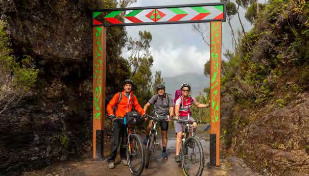
0 25 50 km
Westport
What do I do next? Getting there
Start off at www.doc.govt. The nearest towns are Blackball, Greymouth
nz/paparoatrack for more and Punakaiki. The track can be accessed
information. by road at: Paparoa National
Park Visitor Centre
Reefton
moke-ho car park at the end of
S Punakaiki
BOOK Book your huts online at Blackball Road, 8 km north of Blackball Pike29 Memorial Track
bookings.doc.govt.nz. Pororari River Track car park
PAPAROA TRACK
on SH6, 1.2 km north of the
Blackball
Pancake Rocks at Punakaiki
Book your transport to
GREYMOUTH
and from the track. aikori Road car park
W
on SH6, 2.4 km south
of the Pancake Rocks
Buy your food and pack your Kumara
at Punakaiki.
bags – download the Great Hokitika
Walks packing list and
make sure you have every-
thing you need for a 3 day
independent unguided walk. Know before you go Arthur’s Pass National
Park Visitor Centre
It is important to plan your trip worst. Check metservice.com for
ead up on safety and make
R thoroughly to ensure you stay safe and the most up to date info.
have a great time. Before you go, know
sure you’re well prepared for 4. K
now your limits. Always follow the
the Outdoor Safety Code – 5 simple
your journey and changeable track markers and signposted tracks.
rules to help you #MakeItHomeNZ.
weather at www.doc.govt.nz/ You can expect to walk up to 8 hours a
paparoatrack. 1. P
lan your trip. Travel times vary day depending on your fitness level. If
greatly in New Zealand, so carefully
Franz Josef/Waiau
you get into trouble don’t make a bad
planning your routeWestland
is essential.
Tai Poutini situation worse. Think STAR – Stop /
National
Seek local information Park
about Visitor Centre
what Think / Assess / React.
Check the weather, and
make sure you’ve downloaded to take and allow enough time for
5. T
ake sufficient supplies.
and printed your ticket and the journey. Book accommodation,
With New Zealand’s changeable Methven
official track guide. You can transport and transfers to the start/
weather many hikers are frequently
also pick up a track guide and end of track early.
caught out by isolated local
get the latest weather updates 2. Tell someone your plans.
Aoraki/Mount Cook
Leave conditions. Carry – and expect to
Aoraki/Mt Cook National Park
from the Paparoa National your intentions with a trusted
Visitor Centre use – rain jackets all year round.
Park Visitor Centre. Haast contact, including your trip details Take an extra day’s supply of food ASHBURTON
Awarua/Haast Visitor Centre
and emergency contact information. and an emergency shelter. Don’t
It could save your life if things go rely on cellphone signal alone for
All set! Lace up your boots wrong. Head to mountainsafety. communication. Food and drinks are
and get hiking. Don’t forget org.nz for more information. not available Geraldine
Fairlie to purchase at Great
to share your experience on Walks huts. Plan to be self-sufficient.
3. B
e aware of the weather.
facebook.com/docgovtnz.
New Zealand’s weather is very Temuka
Twizel
changeable. Always prepare for the
Makaroa
TIMARU
Paparoa Track safety
For in-depth and some sections of the track can
become impassable during times of
local knowledge, visit: Weather in the Paparoa National
heavy rain. No river crossings are
Park is changeable with annual
Paparoa National Park required but proceed with caution
rainfall averaging around 6,000 mm
ROUTEBURN
Visitor Centre (235 inches). Heavy rain can occur over bridges.
TRACK with little warning, and unbridged
ound Phone: +64 3 731 1895 Wanaka Waimate
Kurow Go to www.doc.govt.nz/paparoatrack
streams are dangerous in flood.
Tititea/Mount Aspiring
‘Know before you go’ section for detailed
Email: paparoavc@doc.govt.nz National Park Visitor Centre
Be prepared for rain, heavy fog, safety information, and ‘What to take’
snow and high wind, especially on
www.doc.govt.nz/great-walks the exposed sections of the track.
section for a comprehensive gear list.
Arrowtown If the weather becomes severe, Paparoa Track is a shared-use walking
RD
K stay put in a hut or turn back until and mountain bike track all year
Cromwell around.OAMARU
Bikers must give way to hikers.
QUEENSTOWN conditions improve.
Whakatipu-wai-Māori/ Ranfurly Check doc.govt.nz/mountain-bikers-
Published by:
Queenstown Visitor Centre Adverse weather can damage the
Clyde
code for information.
Department of Conservation track significantly. These areas
PO Box 10420, Wellington 6143, New Zealand may be marked by signs and
Alexandra
If you are hiking or biking the track in
warning tape, although you should winter, check snow and ice conditions
October 2020
check with the Paparoa National before you leave and allow extra time.
ACK Editing and design:
Park Visitor Centre or Greymouth If in doubt, consider changing your trip
Te Rōpū Auaha, Te Papa Atawhai to another day.
Palmerston
Te Anau
Creative Services, Department of Conservation DOC Office before your walk.
Te Rua-o-te-moko/Fiordland
National Park Visitor Centre The Pororari River (between Remember
Waikouaiti – your safety is your responsibility
R185113
This publication is produced using paper sourced from
well-managed, renewable and legally logged forests.
Pororari Hut and Punakaiki) can
experience severe flooding events
Mossburn
Lumsden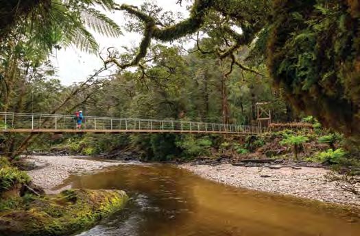
You can also read