Overview No.65-October2021 www.cropmonitor.org - GEOGLAM Crop Monitor
←
→
Page content transcription
If your browser does not render page correctly, please read the page content below
No. 65 – October 2021                                 www.cropmonitor.org

                       Overview

Overview:
In East Africa, harvesting of main/Meher season cereals is underway in
the north with generally favourable conditions except in areas impacted
by ongoing conflict, socio-economic challenges, and flooding.
Conversely, there is concern in the south where persistent dry conditions
are impacting crops and are forecast to continue through the October to
December rainfall season. In West Africa, harvesting of main season
cereals is wrapping up in the north and is just beginning in the south, and
conditions are generally favourable except in regions impacted by
persisting conflict and recent dryness. In the Middle East and North
Africa, land preparation will begin next month for winter wheat, and
conditions remain favourable for rice crops in Egypt, Iraq, and Iran. In
Southern Africa, winter wheat crops are developing under favourable
conditions, and land preparation and planting of main season cereals will
commence in October. In Central and South Asia, harvesting of spring
wheat crops is wrapping up under mixed conditions due to persistent
dryness. Land preparation and planting of winter wheat crops has started
with concern in areas due to dry conditions that are forecast to continue
through Fall and Winter 2021/2022. In Southeast Asia, harvesting of wet-
season rice is underway in the north while harvesting of earlier planted
dry-season rice is underway in Indonesia, and overall conditions are
favourable. In Central America and the Caribbean, harvesting of
Primera/main season cereals finalized under favourable conditions except
in parts of Honduras and localized areas in Guatemala. Planting of
Segunda/Postrera season crops began under favourable conditions.

                                                                              Contents:
                                                                              Conditions at a Glance…………………………………….……………..…......2
                                                                              Global Climate Outlook; Climate Influences ……………..…….……3
                                                                              Desert Locust Update; Seasonal Forecast Alert….…………………..4
                                                                              East Africa & Yemen; Regional Climate Outlook………………..…..6
                                                                              West Africa………………………………………….….….………………..….……10
                                                                              Middle East & North Africa………………………………………….….……11
                                                                              Southern Africa; Regional Climate Outlook……….………....……..11
                                                                              Central & South Asia; Seasonal Forecast Alert…….……….….…..13
                                                                              Southeast Asia…………………………………………………………………………...15
                                                                              Central America & Caribbean ……………………………………….….….…….17
                                                                              Appendix – Terminology & Definitions……………….……….….....19

                                       The Crop Monitor is a part of GEOGLAM, a GEO global initiative.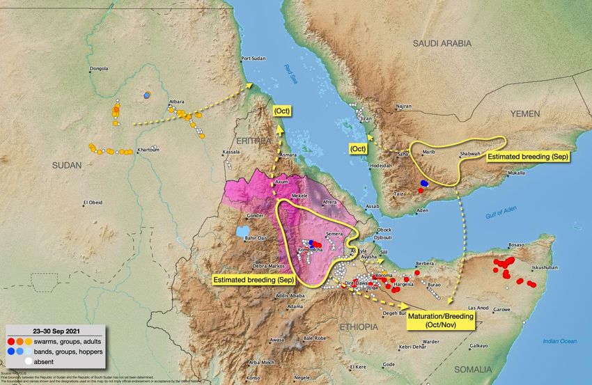
2         No. 65 – October 2021                                                                      Crop Monitor for Early Warning

GEOGLAM Crop Monitor for Early Warning
                                            Crop Conditions at a Glance
                    based on best available information as of September 28th

Crop condition map synthesizing information for all Crop Monitor for Early Warning crops as of September 28th. Crop conditions over the main growing
areas are based on a combination of inputs including remotely sensed data, ground observations, field reports, national, and regional experts. Regions
that are in other than favourable conditions are labeled on the map with a symbol representing the crop(s) affected.

EAST AFRICA: In the north, harvesting of main/Meher season                   above-normal rainfall for central and southeastern areas (See
cereals is underway, and conditions are generally favourable                 Regional Outlook Pg. 12).
except in areas impacted by ongoing conflict, socio-economic                 CENTRAL & SOUTH ASIA: Harvesting of spring wheat is
challenges, and flooding. In the south, land preparation and                 wrapping up under mixed conditions as persistent dryness has
planting of second season cereals is underway with concern in                impacted crops in Afghanistan, Kazakhstan, northern Kyrgyzstan,
areas impacted by persistent dryness which is forecast to                    and eastern Turkmenistan. Land preparation and planting of
continue for the upcoming October to December 2021 rainfall                  2020/2021 winter wheat crops is underway, and below-average
season (See Seasonal Forecast Alert Pg. 5 and Regional Outlook               precipitation is forecast for the Fall and Winter season, which
Pg. 9).                                                                      may worsen irrigation deficits in some areas (See Seasonal
WEST AFRICA: Harvesting of main season maize crops is                        Forecast Alert Pg. 14).
wrapping up in the south while harvesting of main season cereals             SOUTHEAST ASIA: In the north, harvesting of wet-season rice
is underway in the north. Conditions are generally favourable                is underway in some areas, and conditions are generally
except in areas impacted by ongoing conflict and recent dryness.             favourable due to early onset and sufficient rainfall. In Indonesia,
MIDDLE EAST & NORTH AFRICA: Land preparation and                             harvesting of earlier planted dry-season rice is underway with
planting will begin next month for winter wheat across the                   near-average yields despite seasonal delay due to the protracted
region. In Egypt, conditions are favourable for the development              wet-season.
of main season maize and summer-planted rice crops.                          CENTRAL AMERICA & CARIBBEAN: Harvesting of
SOUTHERN AFRICA: Winter wheat crops are developing under                     Primera/main season cereals finalized under generally
favourable conditions across South Africa, Zambia, Zimbabwe,                 favourable conditions except in eastern Honduras and localized
and Lesotho. Land preparation and planting of 2020/2021 main                 areas of Guatemala. Planting of Segunda/Postrera season beans
season cereals will start in full next month, and forecasts indicate         and maize began under favourable conditions.

                                              The Crop Monitor for Early Warning is a part of GEOGLAM,
                                                    a GEO global initiative. www.cropmonitor.org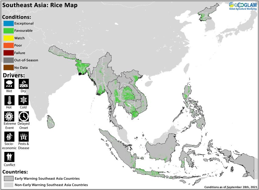
3          No. 65 – October 2021                                                                           Early Warning Crop Monitor

    Global Climate Outlook: 30-day Forecast of Areas with Above or Below-Average Precipitation
    The 30-day precipitation forecast indicates a likelihood of above-average rainfall over western Canada, the central US, Costa Rica,
    Panama, Colombia, southern Venezuela, Guyana, Suriname, French Guiana, Ecuador, Peru, Brazil, northwestern Bolivia, southern
    Paraguay, southern Cameroon, Equatorial Guinea, Gabon, Congo, the Democratic Republic of Congo, western East Africa, eastern
    South Africa, Ireland, the UK, Norway, Sweden, Denmark, Belgium, France, northeastern Spain, eastern Georgia, Azerbaijan,
    northwestern Iran, western Yemen, western Uzbekistan, southern Pakistan, India, Nepal, Bhutan, eastern China, the Democratic
    People’s Republic of Korea, Japan, Laos, Viet Nam, Cambodia, the Philippines, Indonesia, Papua New guinea, and eastern Australia.
    There is also a likelihood of below-average rainfall in parts of eastern Canada, the northeastern US, southern Mexico, Guatemala,
    El Salvador, Honduras, Cuba, southern Brazil, Uruguay, northeastern Argentina, southern Chile, south of the Sahel, eastern East
    Africa, Portugal, Spain, southern China, Myanmar, western Malaysia, western Indonesia, and new Zealand.

    Figure 1. Forecast of areas with above or below-average precipitation over the next 30-days starting on September 30th 2021. The image is the
    multimodel mean of precipitations anomaly from the Subseasonal Experiment (SubX) model forecasts for that day. The anomaly is based on the 1999
    to 2016 model average. Skill assessments of SubX can be accessed here.
    Source: UCSB Climate Hazards Center

    Climate Influences: La Ni ña event likely to develop in October or November and negative IOD event is
    currently underway
    Neutral El Niño-Southern Oscillation (ENSO) conditions are present. A La Niña event will likely develop in October or November
    and persist through early 2022 (78% chance for October to December; 79% to 60% chance for November to March). Climate
    forecasts also anticipate exceptionally warm west Pacific Ocean conditions, which can amplify the impact of cool La Niña conditions
    in the east Pacific.
    La Niña-like conditions typically increase the chances of below-average precipitation in East Africa, Central Asia, southern South
    America, southern United States, northern Mexico, and eastern East Asia. La Niña-like conditions typically increase the chances of
    above-average precipitation in parts of Southeast Asia, Australia, Southern Africa, and northern South America.
    The Indian Ocean Dipole (IOD) is in a weak-negative state. The ongoing negative IOD event weakened in recent weeks, and some
    models forecast it will strengthen in October. Most models forecast a return to neutral by December. Negative IOD conditions
    typically increase the chances of above-average precipitation in Southeast Asia and Australia, and below-average precipitation in
    East Africa.
    Source: UCSB Climate Hazards Center

                                                The Crop Monitor for Early Warning is a part of GEOGLAM,
                                                    a GEO global initiative. www.cropmonitor.org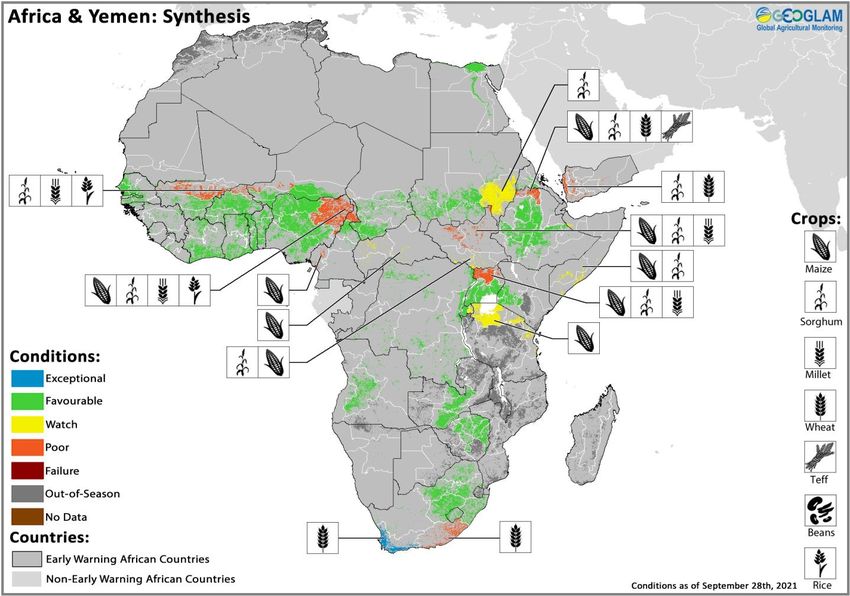
4       No. 65 – October 2021                                                                    Crop Monitor for Early Warning

Desert Locust Update: Swarm migration likely in Eritrea, Djibouti, eastern
Ethiopia, and northern Somalia despite forecasts of below-average rainfall
As of late September, remnants of small immature swarms remained present in eastern Ethiopia and on the plateau in northwest
and northeastern Somalia. As vegetation dries out in northeast and northern Ethiopia, swarms are likely to move northwards
towards the coastal plains in Eritrea and possibly through Djibouti and eastwards to Somali region in Ethiopia and northern
Somalia. While October to November rains are forecast to be below-average in parts of the subregion, they may be sufficient in
northern areas for swarms to mature and lay eggs, giving rise to hopper bands (See Seasonal Forecast Alert Pg. 5 and Regional
Outlook Pg. 9). In particular, October rains in Somali region of Ethiopia and northern Somalia will allow swarms to mature and
lay eggs, giving rise to band formation from November. Swarms that reach Eritrea are also likely to mature and lay eggs with
the onset of winter rains. While the upsurge remains lower in scale compared to the previous year, conflict in Yemen and northern
Ethiopia present a threat to effective control operations.
In northern Ethiopia, the ongoing conflict has hindered control operations, allowing for substantial breeding and threatening
food production in other parts of Ethiopia and in Eritrea. As of mid-September, breeding was underway in southeastern Tigray,
and hoppers were forming small bands. Early instar hopper bands were also reported in neighbouring areas of Afar and eastern
Amhara. As of late September, summer-bred immature swarms began forming in Afar region where late instar hopper bands
were present. While the scale of breeding is not well known, more small immature swarms are likely to form in Afar, Tigray, and
Amhara regions in October. In Yemen, local breeding and hopper bands in the southern interior are resulting in small immature
swarm formation. As of late September, additional immature swarms were forming from previous hopper band infestations in
the interior. Swarms in the interior are likely to move to the Red Sea coast during October and possibly to northern Somalia and
southwestern Saudi Arabia. Elsewhere in the subregion, only small-scale breeding is underway in areas of recent rainfall in Chad
and Sudan.

Figure 1. Desert Locust Situation September 23-30 2021. Source: FAO DLIS

                                             The Crop Monitor for Early Warning is a part of GEOGLAM,
                                                 a GEO global initiative. www.cropmonitor.org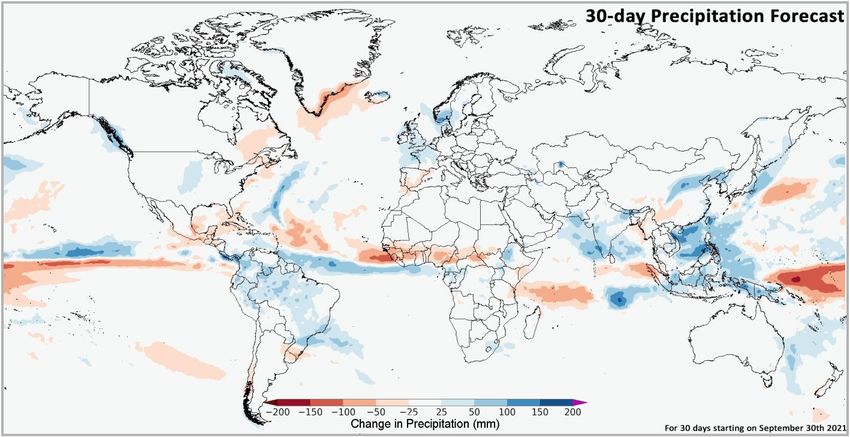
5        No. 65 – October 2021                                                                    Crop Monitor for Early Warning

Seasonal Forecast Alert: Increased likelihood for a third and possibly fourth
consecutive below-average rainfall season across eastern East Africa during OND
2021 and MAM 2022
Given that current sea surface temperature forecasts are very similar to those from last year, it appears likely that there could be a
repeat occurrence of last year’s consecutive poor rainfall seasons in eastern East Africa (Figure 1-left) during the October-
November-December (OND) 2021 season and the March-April-May (MAM) 2022 season. These concerns are founded upon short
and long-range model forecasts, prior research, and outcomes during previous analogous seasons. Climate models indicate
elevated chances of large-scale climate conditions that are conducive to suppressed rainfall during OND and MAM seasons.
The pessimistic OND 2021 rainfall forecasts, from multiple international and regional forecasting centers (See Figure 1-middle and
the Regional Outlook Pg. 9), are consistent with below-average outcomes during previous similar OND seasons with La Niña-like
and negative Indian Ocean Dipole conditions. Based on recent atmospheric and ocean conditions and model forecasts, the Indian
Ocean Dipole may be in a weak negative state, and La Niña conditions are predicted to emerge. Similar to last year, this La Niña
event will likely be accompanied by exceptionally warm west Pacific Ocean conditions. In cases when the eastern Pacific (e.g. the
Nino3.4 region) is only modestly cool, western Pacific sea surface temperatures (SSTs) can still help produce a strong tropical-
extratropical Pacific SST gradient and La Niña-like rainfall impacts in eastern East Africa. Statistical analysis of predicted SSTs for
these influential Indian and Pacific Ocean regions, based on NMME models initialized in early September, suggests a range of near-
average to below-average potential outcomes for OND 2021, with moderate dry conditions (-0.8 SPI value) considered likely.
Similar analyses are detailed in the September 2021 Crop Monitor report and in CHC blogs.
For MAM 2022, the concerns are in line with historical outcomes during similar years. Climate models do not provide reliable long-
range predictions for MAM rainfall in eastern East Africa. Useful long-range indicators include the forecast La Niña 2021-2022 event
and the forecast Pacific Ocean “Western V” SST tropical-extratropical gradient (WVG) for MAM 2022. In Figure 1-right, 6-month
lead NMME forecasts for WVG conditions during March-April-May are shown to be reasonably reliable due to the models’ skill at
forecasting La Niña-related SST variations and the strong warming trends in the western Pacific. In years when climate models
forecast a strong negative WVG, as they do for MAM 2022 (red circle), many MAM seasons had below-normal rainfall (orange
circles show all below-normal seasons). Long-range MAM 2022 outlooks for the eastern Horn highlight the predictability of MAM
droughts and are detailed here. MAM composites based on recent La Niña events reach a similar pessimistic conclusion, as
described here. These concerns focus on eastern East Africa, where rains have been poor, and the OND 2021 outlook is pessimistic
(Figure 1-left).
In short, forecast large-scale conditions are similar to last year. While there are limitations to accuracy and precision in climate
model forecasts and historical comparisons, this information underscores the possibility that areas that recently endured
challenging conditions for crops and livestock are again at risk for consecutive droughts.

Figure 1. Consecutive droughts in eastern East Africa, forecast below-normal OND 2021 precipitation, and indications for a potential below-normal
MAM 2022 season. Left— Map showing areas with severe rainfall deficits during OND 2020 (brown), MAM 2021 (bright red), and during both these
seasons (dark red). Severe deficits are defined as totals being in the driest third of the 1981-2020 seasons, based on CHIRPS data. Middle — WMO
probabilistic forecast for October-November-December (OND) 2021 precipitation, based on models initialized in September. The overlay shows the
importance of OND rainfall to annual totals. Base image from WMO Lead Centre Long-Range Forecast Multi-Model Ensemble. Right— Scatterplot of
predicted and observed MAM Western V Gradient (WVG) values. Forecasts based on September NMME predictions. There is a 90% chance of strong
Pacific Ocean sea surface temperature WVG gradient conditions. The red circle shows the 2022 forecast. All below-normal eastern East African MAM
rainy seasons are noted with orange circles. When strong negative WVG values have occurred or been predicted, below-normal MAM rains have been
likely. More details are provided in a Climate Hazards Center Blog (http://blog.chc.ucsb.edu/?p=1030).
Source: Climate Hazards Center

                                              The Crop Monitor for Early Warning is a part of GEOGLAM,
                                                  a GEO global initiative. www.cropmonitor.org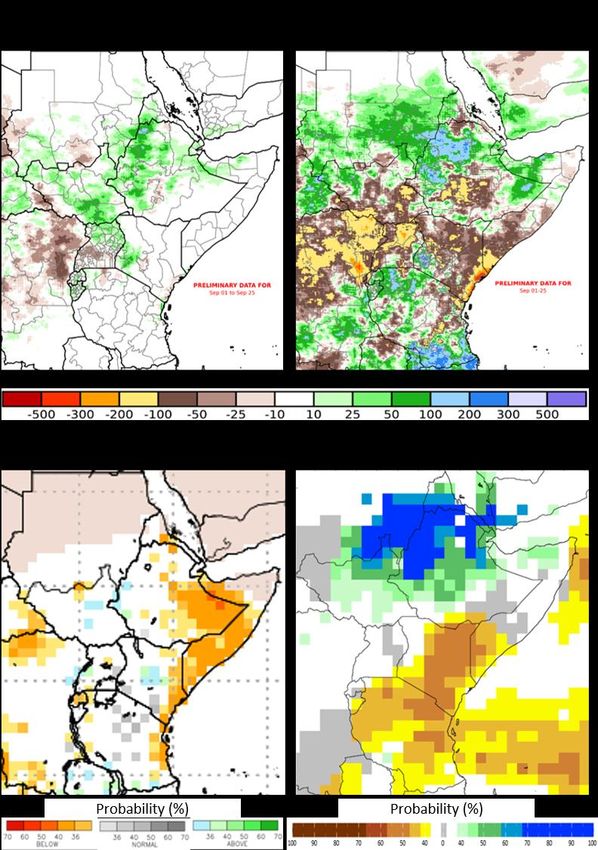
6          No. 65 – October 2021                                                                      Crop Monitor for Early Warning

East Africa & Yemen

Crop condition map synthesizing Maize 1 crop conditions as of September 28th. Crop conditions over the main growing areas are based on a combination
of inputs including remotely sensed data, ground observations, field reports, national, and regional experts. Conditions that are other than favourable
are labeled on the map with their driver.

In the north of the subregion, harvesting of main/Meher season
cereals is underway in Ethiopia while crops continue to
develop in Djibouti, Eritrea, South Sudan, and Sudan. Also,
harvesting of wheat crops finalized in Yemen, and sorghum
harvest is underway while planting of second season cereals is
underway in southern South Sudan. Poor conditions resulted
in Tigray Ethiopia, Yemen, and South Sudan due to conflict
and socio-economic challenges, and there is continued
concern in eastern Sudan and northern South Sudan due to
recent heavy rainfall and flooding. Flooding in August and
September is a regular problem throughout the region as
monsoon rains in the Ethiopian Highlands flow down to the
Blue Nile and White Nile, impacting adjacent areas through
Sudan and South Sudan. This year, more than 700,000 people
in Sudan and South Sudan have been affected by ongoing
floods since the start of the rainy season in July. Across the
south of the subregion, harvesting of main season cereals
finalized last month, and below to well below-average yields          For detailed description of the pie chart please see description box on Pg. 18.
resulted for main season cereals in northeastern Kenya,
northern Uganda, and Somalia while crops continue to develop in unimodal rainfall areas of Kenya under favourable conditions.
There is concern for second season cereals in eastern Rwanda, northern Uganda, Somalia, and the United Republic of Tanzania
currently under land preparation and planting due to persistent dryness. Throughout 2021, prolonged rainfall deficits have resulted
in dry conditions over many central and southern parts of the subregion. For the upcoming October to December rainfall season,
drier than normal conditions associated with the forecast La Niña event are likely in parts of eastern and southern East Africa,
particularly in the cross-border areas of Kenya and Somalia. Furthermore, warmer than normal temperatures are expected in many
parts of the subregion, particularly in eastern Kenya to Somalia, eastern Ethiopia, and eastern Sudan. Carryover dry conditions in

                                                 The Crop Monitor for Early Warning is a part of GEOGLAM,
                                                     a GEO global initiative. www.cropmonitor.org
7         No. 65 – October 2021                                                                   Crop Monitor for Early Warning

                                                                                              combination with forecasts of continued dry
                                                                                              conditions are a concern and may result in
                                                                                              moderate to severe drought and water stress in
                                                                                              parts of the subregion. (See Seasonal Forecast
                                                                                              Alert Pg. 5 and Regional Outlook Pg. 9).

                                                                                              Northern East Africa & Yemen

                                                                                              In Ethiopia, harvesting of Meher season (Long
                                                                                              Rains) cereals began under generally
                                                                                              favourable conditions due to good rainfall.
                                                                                              However, dams and reservoirs across the
                                                                                              country have reached maximum capacity due
                                                                                              to ongoing summer rainfall, including at Gilgel
                                                                                              Gibe, Tana Beles, Fincha, and Keseme sites.
                                                                                              Additionally, crops in Tigray region are unlikely
                                                                                              to recover as ongoing conflict and socio-
                                                                                              economic challenges continue to impact
                                                                                              agricultural production. Only 25 to 50 percent
                                                                                              of the normal cereal production is expected in
Crop condition map synthesizing Sorghum 1 conditions as of September 28th. Crop conditions Tigray this year as the planting season has been
over the main growing areas are based on a combination of inputs including remotely sensed
                                                                                              missed in many areas due to the protracted
data, ground observations, field reports, national, and regional experts. Conditions that are
other than favourable are labeled on the map with their driver.
                                                                                              conflict. Limited fuel and cash is also hindering
                                                                                              transportation of agricultural inputs. In Sudan,
main season millet and sorghum crops are in vegetative to reproductive stage for harvest from November, and conditions are
generally favourable due to above-average seasonal rainfall. However, there is concern in the east due to potential flood impacts. In
2020, record-breaking flooding affected 850,000 people across the country. From the start of this year’s rainy season in July, heavy
rains and flash flooding have compounded last year’s impacts, affecting over 303,000 people in 13 states. River Nile, Al Jazirah,
Gedaref, and White Nile states are the most affected. Water levels of the Nile River were above flood risk level as of mid-September;
however, they appeared to have been falling as of September 22nd, and the extent of flood water was decreasing in some areas.
Additional light rainfall is expected over southern areas, though the rainfall season typically ends in September (See Regional Outlook
Pg. 9). In South Sudan, first season cereals are in vegetative to reproductive stage for harvest from October while planting of second
season maize and sorghum crops continues in the south, and crops are unlikely to recover due to ongoing conflict and socio-economic
challenges, dry conditions in the south, and impacts from flooding in the north. From May of this year, heavy rain and flooding has
affected thousands along the river Nile, Sudd wetlands, and Lol and Sobat rivers, compounding the flooding from August to
September of 2020 that affected over 600,000 people across the country. The most affected areas last year were in Jonglei, Pibor,
Upper Nile, Unity, Western Equatoria, and Eastern Equatoria states. From May of this year, ongoing flooding has affected or displaced
426,000 people throughout the country, with Jonglei, Unity, Northern Bahr el Ghazal, Upper Nile, Warrap, and Western Equatoria
being the most affected. Forecast heavy rains and flooding are expected to continue across the north in the coming months (See
Regional Outlook Pg. 9). In Djibouti, main season millet and sorghum crops are developing under favourable conditions, and harvest
will take place from November. In Eritrea, winter wheat and main season sorghum crops are developing under favourable conditions
for harvest from November. The June to September Kiremti rainy season produced a timely rainfall onset and above-average
precipitation in July, followed by below-average precipitation in August. However, vegetation conditions remain favourable,
particularly in the major producing western Gash Barka region. Forecast above-average rainfall for the remainder of the Kiremti rainy
season is likely to benefit yields (See Regional Outlook Pg. 9). In Yemen, harvesting of wheat crops finalized in September while
harvesting of main season sorghum crops is underway, and conditions are poor throughout the country due to persistent socio-
economic challenges and conflict. While previous torrential rainfall and flooding in the east and west resulted in localized damages,
above-average rainfall also improved soil moisture reserves.

Southern East Africa

In Uganda, harvesting of main season cereals is complete or nearing completion with below-average yields expected in the North
and Karamoja due to persistent dryness throughout the season. In Karamoja region, the April to September rainy season began with
a delayed onset, negatively impacting planting and germination. Heavy rains in early May resulted in flooding and waterlogging and
were followed by below-average precipitation in late May through June. Despite a slight improvement in vegetation conditions in
July with above-average rainfall, rainfall was again below-average in August. Due to the impacts of erratic rainfall and flooding, planted
area is below-average, and harvests are delayed by a month and are expected to be below-average. Similarly, in the northwest, overall
production is estimated at below-average levels as delayed onset and erratic March to June rains resulted in abnormal dryness in
some areas, significantly affecting yields. Conversely, torrential rains in July resulted in the overflow of Lake Kyoga, resulting in
damaged infrastructure and localized crop loss. Throughout the country, planting and development of second season maize crops is
underway for harvest from October, and overall conditions are favourable. However, from early September, heavy rain caused the
Nyamwamba river to break its banks, and flooding has occurred in Kasese District in the southwest. Also, from mid-September, severe
flooding and landslides impacted Sironko, Kapchorwa, Mbale, and Kween districts of the Eastern region.

                                              The Crop Monitor for Early Warning is a part of GEOGLAM,
                                                  a GEO global initiative. www.cropmonitor.org
8         No. 65 – October 2021                                                                   Crop Monitor for Early Warning

                                                                                                  In Kenya, harvesting of main season crops
                                                                                                  finalized in August in the marginal
                                                                                                  producing east, coast, and northeast with
                                                                                                  failure conditions for maize due to below-
                                                                                                  average and erratic rainfall. Conversely,
                                                                                                  favourable conditions resulted for sorghum
                                                                                                  crops as they are more resilient to drought
                                                                                                  stress. Current conditions are favourable for
                                                                                                  the ongoing development of Long Rains
                                                                                                  cereals in the main producing unimodal
                                                                                                  central, Rift Valley, and west regions.
                                                                                                  However, at the beginning of September,
                                                                                                  the country declared a state of disaster due
                                                                                                  to worsening drought conditions, and
                                                                                                  October to December rains are expected at
                                                                                                  below-normal levels (See Seasonal Forecast
                                                                                                  Alert Pg. 5 and Regional Outlook Pg. 9). In
                                                                                                  Somalia, planting of Deyr season sorghum
                                                                                                  crops is underway, and there is concern as
                                                                                                  dry conditions are impacting planting
 Crop condition map synthesizing Maize 2 conditions as of September 28 . Crop conditions over the
                                                                      th

 main growing areas are based on a combination of inputs including remotely sensed data, ground
                                                                                                  activities. Also, October to December Deyr
 observations, field reports, national, and regional experts. Conditions that are other than seasonal rainfall is forecast to be below-
 favourable are labeled on the map with their driver.                                             average and is likely to impact crop
                                                                                                  development for a further consecutive
season (See Seasonal Forecast Alert Pg. 5 and Regional Outlook Pg. 9). In Burundi, harvesting of main season rice crops finalized in
the northeast under favourable conditions. Land preparation is underway for second Season A maize crops, and planting will begin
next month. In Rwanda, planting of second Season A maize crops is underway, and there is concern in the east as below-average
rainfall is impacting planting activities. In the United Republic of Tanzania, planting of Vuli season maize crops is underway in
northern bimodal rainfall areas, and there is concern as delayed rainfall onset and dry conditions are impacting planting activities.
Rainfall amounts are expected to be below-average between October to December, which may have a negative impact on Vuli season
crop development as well as planting and development of 2022 Msimu crops (See Seasonal Forecast Alert Pg. 5 and Regional Outlook
Pg. 9).

                                              The Crop Monitor for Early Warning is a part of GEOGLAM,
                                                  a GEO global initiative. www.cropmonitor.org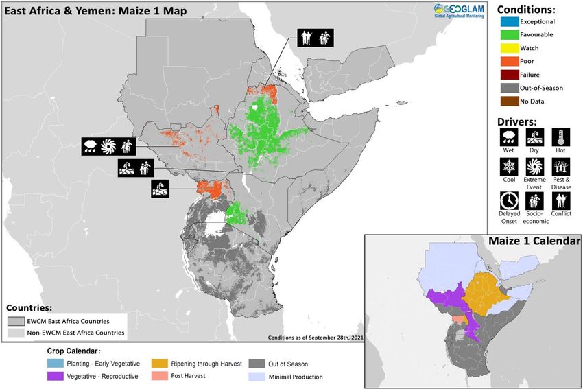
9       No. 65 – October 2021                                                                        Crop Monitor for Early Warning

Regional Outlook: Wet conditions expected to continue in the north while below-
average rainfall is likely in parts of the east and south for the OND season
In recent weeks, wetter-than-average conditions affected Ethiopia, South Sudan, northern Uganda, and western Kenya, as well as
portions of eastern and southwestern Sudan and northwestern Somalia (Figure 1-left). Periodic heavy rains led to oversaturated
ground conditions and elevated river levels in South Sudan and eastern Sudan, and there is a continued risk for flooding that has
already caused widespread population displacement in recent months. Areas in Sudan, northern South Sudan, and northwestern
Ethiopia received above-average rainfall through much of the March-to-September (Figure 1- right) and June-to-September
seasons, while drier-than-average conditions affected many central and southern areas of the region. In northern Uganda, the
recent wet conditions came after persistently below-average rainfall during the March-April and in June-July-August periods.
Similarly, poorly distributed seasonal rains and historically very low amounts affected areas in Ethiopia’s central Rift Valley and
eastern Oromia region, as shown in Figure 1-middle and the latest assessment for Ethiopia’s March-to-November season.
                                                                            Importantly, a series of poor rainfall seasons recently
                                                                            impacted the eastern Horn, and there are presently
                                                                            elevated chances for this to transpire again during the
                                                                            October-November-December (OND) 2021 and
                                                                            March-April-May 2022 seasons (See Seasonal
                                                                            Forecast Alert Pg. 5). For the OND season, below-
                                                                            normal rainfall and above-normal temperatures are
                                                                            forecast in eastern areas of the region, including in
                                                                            eastern Kenya, southeastern Ethiopia, and southern
                                                                            Somalia. Climate models show some differences in the
                                                                            geographical extent of the elevated chances for
                                                                            below-normal rainfall. The NMME probabilistic
                                                                            ensemble forecast (Figure 1-bottom left) is more
                                                                            conservative in this regard, while WMO and ICPAC
                                                                            GHACOF forecasts also include central Kenya and
                                                                            other western and southern countries.
                                                                            The latest SubX probabilistic forecast indicates
                                                                            increased chances for below-normal rainfall during
                                                                            October 9th to October 22nd in southern Somalia,
                                                                            Kenya, Tanzania, Burundi, and southern Ethiopia
                                                                            (Figure 1-bottom right). Continued wet conditions are
                                                                            forecast in northern Ethiopia, eastern Sudan, and
                                                                            northern South Sudan. Heavy rain may affect areas
                                                                            across central Ethiopia during September 27th to
                                                                            October 4th, based on the ICPAC East Africa Hazards
                                                                            Watch.

Figure 1. A 6-pentad rainfall anomaly, March-to-September rainfall anomaly, 3-month rainfall anomaly probability forecast, and a 2-
week rainfall anomaly probability forecast. The top panels are CHC Early Estimates, which compare 2021 rainfall amounts to the 1981-2020
CHIRPS average. These show the rainfall anomaly, in mm, for August 26th to September 25th (left) and March 1st to September 25th(right). The bottom-
left panel shows the NMME probabilistic forecast for October-November-December (OND) 2021 precipitation, based on September initial conditions.
Colors indicate the dominant tercile category forecast across models; white indicates no dominant category. NMME image from NOAA CPC. The
bottom-right panel shows the IRI SubX Precipitation Biweekly Probability Forecast for October 9th to 22nd, issued on October 1st. The forecast is based
on statistically-calibrated tercile category forecasts from three SubX models. Image from the IRI Subseasonal Forecasts Maproom. Source: UCSB Climate
Hazards Center

                                               The Crop Monitor for Early Warning is a part of GEOGLAM,
                                                   a GEO global initiative. www.cropmonitor.org
10        No. 65 – October 2021                                                                      Crop Monitor for Early Warning

West Africa

Crop condition map synthesizing information as of September 28th. Crop conditions over the main growing areas are based on a combination of inputs
including remotely sensed data, ground observations, field reports, national, and regional experts. Crops that are in other than favourable conditions
are labeled on the map with their driver.

In the south of the subregion, harvesting of main season maize finalized in Liberia, Cote d’Ivoire, southern Ghana, southern Togo,
central and southern Benin, and northeastern Nigeria while harvest continues in northern Ghana, northern Togo, northern Benin,
northern Cameroon, and southwestern Chad. Main season sorghum crops continue to develop in Cote d’Ivoire, northern Ghana,
Togo, central and northern Benin, and central Cameroon while harvest begins in northern Cameroon and the southern half of Chad.
Planting and development of second season cereals is underway in Cote d’Ivoire, southern Ghana, southern Togo, southern Benin,
Nigeria, and central Cameroon while harvest is now complete in southern Cameroon. In the north of the subregion, harvesting of
main season cereals is underway in Mali, Burkina Faso, Niger, eastern Senegal, and Guinea-Bissau while crops continue to develop
in Guinea, Mauritania, and Gambia. Throughout the subregion, conditions are generally favourable due to good rainfall received.
However, there is concern in regions impacted by ongoing conflict, parts of northern Cameroon, central Mali, and western Niger
affected by early season dryness and rainfall deficits, and in localized parts of southern Chad impacted by ongoing flooding. Drier-
than-average conditions forecast across central and northern areas, from Senegal to northern Nigeria, indicate an early end to the
main rainy season.
In northeastern Nigeria, the Southwest and Far North regions of Cameroon, northern Burkina Faso, central Mali, and western Niger,
poor conditions resulted for main and second season maize crops due to persisting conflict. In northeast and northcentral Nigeria,
protracted insecurity continues to impact prices of agricultural inputs and result in disruptions to farming and marketing activities.
Concern also remains in Lac region in Chad and the Central African Republic where conflict continues to disrupt agricultural
activities. Additionally, in the Far North region of Cameroon, dry weather conditions in some areas delayed sowing activities and
reduced the area planted, and below-average precipitation in the second dekad of September may negatively impact crop
development in some areas. In central Mali and western Niger, rainfall deficits in July were compounded by a severe deficit in
September, which is likely to impact crops at critical flowering and maturation stages and exacerbate poor conditions resulting from
ongoing conflict. In Mauritania, yield prospects are near-average despite erratic and below-average precipitation from the beginning
of the season. Improved rainfall in September is supporting rainfed crops, and high reservoir levels are supporting irrigated fields.
Furthermore, heavy rainfall during the ongoing rainy season has resulted in flooding across parts of Chad, northeastern Nigeria,
northwestern Ghana, southern Benin, and Gambia, hindering agricultural activities and leading to localized crop losses. In Chad,
torrential rains in the southwest of the country triggered floods that caused localized crop losses and disruptions to agricultural
activities, notably in Tandjilé and Mandoul regions. In Guinea, heavy rainfall fell over most parts of the country in late August, resulting
in flooding in Siguiri and Guéckédou prefectures as well as the capital Conakry.

                                                The Crop Monitor for Early Warning is a part of GEOGLAM,
                                                    a GEO global initiative. www.cropmonitor.org
11 No. 65 – October 2021 Crop Monitor for Early Warning
Middle East & North Africa
In the Middle East and North Africa, land preparation for winter wheat is underway, and planting will begin next month in Algeria,
Iran, Iraq, Libya, Morocco, Syria, and Tunisia. In Egypt, harvesting of summer-planted rice crops is underway while Nili season (Nile
Flood) rice and main season maize crops continue to develop for harvest from October. Conditions remain favourable as there is
sufficient irrigation water supply for mostly irrigated crops. In Iraq, harvesting of irrigated summer crops is ongoing with favourable
prospects for rice. In Iran, harvesting of rice crops is underway earlier than normal due to high temperatures, and prospects are close
to average except in Golestan and Khorasan in the northeast and in Esfahan due to reduction of the cultivated area.
Southern Africa
Crop condition map synthesizing information as of September 28th. Crop conditions over the main growing areas are based on a combination of inputs
including remotely sensed data, ground observations, field reports, national, and regional experts. Crops that are in other than favourable conditions
are labeled on the map with their driver.
In Southern Africa, harvesting of winter wheat crops is underway in Zimbabwe while crops continue to develop in Lesotho, South
Africa, and Zambia for harvest from October. Overall conditions are generally favourable, particularly in Zimbabwe where a record
crop is expected as well as in the major producing Western Cape of South Africa where rainfall has been beneficial for crop
development. However, crops in the minor producing Eastern Cape of South Africa are unlikely to recover from dry conditions. Also,
in Lesotho, area planted is reported to be below-average due to limited availability of inputs. In the Democratic Republic of Congo,
harvesting of main season sorghum crops is underway in the north while planting and development of main season cereals continues
throughout the country. While agrometeorological conditions have generally been conducive for crop development, there are reports
of limited agricultural inputs.
Land preparation of main season cereals is underway, and planting has begun in Angola under favourable conditions. Next month,
planting will begin in eSwatini, Lesotho, Mozambique, and Zambia. Early forecasts suggest a likelihood of average or above-average
rains during key rainfall months of the cropping season, which is likely to benefit production prospects in some of these areas (See
Regional Outlook Pg. 12).
The Crop Monitor for Early Warning is a part of GEOGLAM,
a GEO global initiative. www.cropmonitor.org12 No. 65 – October 2021 Crop Monitor for Early Warning
Regional Outlook: Above-normal rainfall forecast for central and southeastern
areas during December 2021 to February 2022
During December 2021 to February 2022, key rainfall months for the main growing season, long-range forecasts from the SARCOF
(Figure 1-left) and the NMME (Figure 1-right) indicate elevated chances for above-normal rainfall in some central to southeastern
areas, including in Zimbabwe, Botswana, northeastern South Africa, eSwatini, and southern Mozambique. This is consistent with a
historical tendency for La Niña-like conditions to enhance rainfall in this part of the region. La Niña-like conditions appear to be
developing, and a La Niña is forecast to emerge and continue into early 2022 (See Climate Influences Pg. 3). Last year, during
similar climate conditions, many of these areas experienced above-average rainfall and some experienced damages from severe
weather and flooding. According to SubX 30-day and ECMWF extended-range forecasts (not shown), there are increased chances
for above-average rainfall in some southeastern areas of the region in coming weeks.
An area of concern for a poor 2021-2022 season is southwestern Angola, where extremely dry conditions prevailed during the
2020-2021 season and where the NMME, C3S, and WMO forecasts show increased chances for below-normal DJF 2021-2022
rainfall.
Figure 1. Forecast probabilities for above- and below-normal December-January-February (DJF) 2021-2022 rainfall. On the left is the
Southern Africa Regional Climate Outlook Forum (SARCOF) forecast for DJF 2021-2022. Image from the Southern Africa Development Community’s
Statement from the 25th Annual SARCOF, held on 30-31 August, 2021. On the right is the NMME probabilistic forecast for DJF 2021-2022, based on
September initial conditions. The forecast probability is calculated as the percentage of all 79 NMME ensemble members that fall in a given tercile
(above/below/near-normal). White color indicates there is no dominant category across the model forecasts. NMME image from NOAA CPC.
Source: UCSB Climate Hazards Center
The Crop Monitor for Early Warning is a part of GEOGLAM,
a GEO global initiative. www.cropmonitor.org13 No. 65 – October 2021 Crop Monitor for Early Warning
Central & South Asia
Crop condition map synthesizing Spring Wheat information as of September 28th. Crop conditions over the main growing areas are based on a
combination of inputs including remotely sensed data, ground observations, field reports, national, and regional experts. Crops that are in other than
favourable conditions are labeled on the map with their driver.
In Central and South Asia, harvesting of winter wheat crops finalized last month under mixed conditions due to persistent dryness
throughout the season. Land preparation and planting of winter wheat crops is underway in Kyrgyzstan, Tajikistan and southern
Kazakhstan under favourable conditions. Land preparation and planting will begin next month in Afghanistan, Pakistan,
Turkmenistan, and Uzbekistan; however, forecasts indicate an increased likelihood of below-average precipitation through February
2022 (See Seasonal Forecast Alert Pg. 14). In Pakistan, Kharif (summer) season rice crops continue to develop under favourable
conditions for harvest from October. In Punjab, production prospects are near-average while prospects in Balochistan and Sindh are
slightly below-average due to reduced irrigated area.
Harvesting of spring wheat crops
finalized last month in Afghanistan and
is wrapping up in Kazakhstan,
Kyrgyzstan, Mongolia, Tajikistan, and
Turkmenistan under mixed conditions.
Poor conditions resulted in north, west,
and southern Afghanistan and in
Kazakhstan, and there is ongoing
concern in northern Kyrgyzstan and
eastern Turkmenistan due to persistent
dryness throughout the growing
season. In Kazakhstan, total production
(winter and spring crops) is estimated to
be 13 percent below-average due to
insufficient rains in the north, where
spring wheat is cultivated and where 95
percent of total annual wheat is
Crop condition map synthesizing Winter Wheat conditions as of September 28th. Crop conditions over
produced. In Kyrgyzstan, there is
the main growing areas are based on a combination of inputs including remotely sensed data, ground
observations, field reports, national, and regional experts. Conditions that are other than favourable
continued concern in the north as
are labeled on the map with their driver. below-average precipitation amounts
during the growing season negatively
affected vegetation conditions in the Chui region. In Mongolia, area planted is estimated at an above-average level, supported by
Government programmes aiming to increase local production and prevent shortages of wheat flour during the COVID-19 pandemic.
Similarly, yields are estimated at an above-average level, reflecting generally favourable conditions and adequate irrigation water
supply. Production is also estimated to be well above-average at 500,000 tonnes.
The Crop Monitor for Early Warning is a part of GEOGLAM,
a GEO global initiative. www.cropmonitor.org14 No. 65 – October 2021 Crop Monitor for Early Warning
Seasonal Forecast Alert: Increased risk of second consecutive season of below -
average precipitation forecast for Fall and Winter 2021 -2022
There is an increased risk of another season of below-
average precipitation in Central and Southwest Asia
during the Northern Hemisphere fall and winter of
2021-2022, according to multiple forecasting centers.
The at-risk regions include areas that were negatively
impacted by dry weather conditions during the 2020-
2021 winter wheat and spring wheat growing
seasons.
The WMO forecast from September (Figure 1)
indicates greater-than-50% chances of below-normal
precipitation in central and northern Afghanistan,
southern Turkmenistan, southern Uzbekistan, and
southern Tajikistan. Similar to other forecasts, there
are elevated chances for below-normal precipitation
across Central and Southwest Asia. This is consistent
with the typical drying impacts of La Niña conditions,
which are forecast to develop and continue into early
2022. Even in the absence of a full La Niña, however,
La Niña-like climate can lead to dry conditions over
this region.
Figure 1. WMO probabilistic forecast for October-to-January 2021-2022 The possibility of below-normal precipitation during
precipitation, based on models initialized in August. From WMO Lead Centre the upcoming season is highly concerning. During
Long-Range Forecast Multi-Model Ensemble. Right-- Model estimates for 2021 2020-2021, low precipitation impacted soil moisture
streamflow at the Helmand River. The green line shows 2021 streamflow rates
and irrigation supply, leading to water deficits during
below the 25th percentile, indicating rates among the lowest of 2001 to
key months of crop development and resulted in poor
2020. From the USGS FEWS NET Data Portal “Afghanistan Streamflow and
Runoff.” Source: Climate Hazards Center and failed crop conditions for winter wheat across
parts of the region. Poor or mediocre early to mid-
season precipitation performance this year could
produce lasting negative impacts on crops, low
snowpack levels, and limited irrigation and could
prolong recovery from 2020-2021 drought impacts in
affected areas of the region.
The Crop Monitor for Early Warning is a part of GEOGLAM,
a GEO global initiative. www.cropmonitor.org15 No. 65 – October 2021 Crop Monitor for Early Warning
Southeast Asia
Crop condition map synthesizing rice conditions as of September 28th. Crop conditions over the main growing areas are based on a combination of inputs
including remotely sensed data, ground observations, field reports, national, and regional experts. Crops that are in other than favourable conditions
are labeled on the map with their driver.
In northern Southeast Asia, planting of wet-season rice is now complete, and crops are in young panicle forming to harvesting stage
under favourable conditions. Overall planted area has increased compared to the previous year due to early onset and sufficient
rainfall. Growing conditions are expected to remain stable with forecasts of continued normal to above-normal rainfall. Harvesting of
earlier planted crops is underway in some areas with near-average yields. In Indonesia, harvesting of earlier planted dry-season rice
is underway with yield slightly higher than the previous year due
to sufficient precipitation received during the growing season.
While September is typically the last month of planting, progress
is lower than last year due to the protracted wet-season.
Additionally, while recent rainfall has decreased in the South, it
continues in the North with average to above-average levels. In
the Philippines, harvesting of wet-season rice planted in April to
May is now complete with production slightly higher than the
previous year’s level. Crops planted in July and August are now in
the tillering stage, and growing conditions are favourable as most
parts of the country are likely to benefit from near to above-
average rainfall. Tropical cyclone and southwest monsoon rains
continue to affect the country, particularly in Luzon and Visayas
provinces. In Thailand, wet-season rice is in young panicle
forming stage, and planted area has increased due to favourable
weather conditions and good paddy prices. Growing conditions
have improved from the previous year due to abundant rainfall
from April, and final yield and production are expected to
increase. However, continuous heavy rainfall from the end of For detailed description of the pie chart please see description box on Pg. 18.
August to September in the Northern and Northeastern regions
The Crop Monitor for Early Warning is a part of GEOGLAM,
a GEO global initiative. www.cropmonitor.org16 No. 65 – October 2021 Crop Monitor for Early Warning
resulted in flooding and affected 1,600 hectares of crop area. In northern Viet Nam, wet-season rice is in young panicle forming to
grain filling stage under favourable conditions due to better irrigation preparation than the previous year. In the South, harvesting of
summer-autumn (wet-season) rice is underway, and yield is slightly improved from the previous year due to sufficient irrigation water
supply. Harvested area has reached 1.02 million hectares out of 1.77 million hectares planted. Autumn-winter (wet-season) rice is in
seeding, tillering, and young panicle forming stages under favourable conditions. In Laos, wet-season rice is in young panicle forming
to grain filling stage. In lowland areas, growing conditions remain favourable as weather conditions and irrigation water availability
are sufficient for paddy development. Growing conditions are also favourable in upland areas, and the rainy season is expected to
produce adequate precipitation. In Myanmar, planting of wet-season rice is nearing completion, and crops are in panicle forming
stage under favourable conditions. Planting progress is slightly faster than the previous year due to good monsoon rainfall. However,
heavy rains also resulted in monsoon flooding in most areas. Approximately 15,000 hectares were affected, and 7,000 hectares were
damaged. Replanting activities will be carried out for damaged fields. In Cambodia, planted area of wet-season rice reached 2.77
million hectares, accounting for 106 percent of the national planting plan. Despite drought conditions in some areas, last month’s
rainfall was sufficient for adequate crop growth, and crops in drought-affected areas are recovering. For early planted crops, 44
percent of the cultivated area was harvested, and yield is estimated to be near-average at 4 tons per hectare. In Sri Lanka, harvesting
of Yala season rice and maize crops is wrapping up under favourable conditions, and production is estimated at an above-average
level. Land preparation is underway for planting of Maha season rice and maize crops, and planting will begin next month. In
Bangladesh, Aman season rice crops are developing under favourable conditions despite flooding in July and August that resulted
in localized crop losses. In Nepal, harvesting of main season maize crops finalized in September while main season rice crops continue
to develop, and overall conditions are favourable. Production of rice and maize crops is forecast to be above the five-year average,
reflecting above-average planted area and yields that were supported by generally favourable weather conditions, high-yielding seed
varieties, and use of fertilizers. However, from late August, an intensification of monsoon rains inundated the southern plains, affecting
11 districts with localized flooding and landslides. In the Democratic People’s Republic of Korea, harvesting of main season maize
crops finalized under favourable conditions with above-average biomass. Harvesting of main season rice crops continued under
favourable conditions and will finalize in October. While below-average rainfall was received in the southern rice bowl area, crop
biomass is above-average as there was sufficient water supply to irrigate crops, benefitting crop development.
The Crop Monitor for Early Warning is a part of GEOGLAM,
a GEO global initiative. www.cropmonitor.org17 No. 65 – October 2021 Crop Monitor for Early Warning
Central America & Caribbean
Crop condition map synthesizing Segunda season conditions as of September 28th. Crop conditions over
the main growing areas are based on a combination of inputs including remotely sensed data, ground
observations, field reports, national, and regional experts. Conditions that are other than favourable
are labeled on the map with their driver.
Crop condition map synthesizing information as of September 28th. Crop conditions over the main growing areas are based on a combination of inputs
including remotely sensed data, ground observations, field reports, national, and regional experts. Conditions that are other than favourable are
labeled on the map with their driver.
In Central America, harvesting of Primera season maize and
bean crops finalized in El Salvador, Guatemala, Honduras,
and Nicaragua under generally favourable conditions
except in eastern Honduras where delayed rainfall onset and
seasonal dryness resulted in below-average yields. In
Guatemala, end of season conditions for Primera season
crops are favourable despite delayed onset and irregular
distribution of rainfall. While localized crop losses were
reported in Zacapa, Escuintla, Chiquimula, Guatemala, Jalapa,
Baja Verapaz, Suchitepéquez, Jutiapa, and Santa Rosa
departments, the government estimated the losses have not
affected production at the national level. However,
subsistence farmers in lowland areas have reported yield
reductions due to rainfall deficits during the July to August
period followed by flash floods in late August and early
September. In Honduras, favourable conditions resulted for
Primera season maize and bean crops in the west while
delayed seasonal rainfall onset by 30 days affected crop
yields and caused crop losses in the east, including parts of For detailed description of the pie chart please see description box on Pg. 18.
Olancho, El Paraiso, Francisco Morazán, Choluteca, and Valle
departments. While precipitation improvements from the third dekad of June helped restore moisture deficits, crops were affected
by erratic rainfall distribution throughout the season, and production is expected to be average to below-average for both large and
subsistence farmers in affected regions. However, national production is expected to remain near-average. Harvesting of main season
rice crops continued in September while planting of second season rice crops is underway, and overall conditions are favourable. In
Nicaragua, Primera season maize and bean crop yields are forecast to be slightly below-average in localized central northern areas
as significantly below-average precipitation in May affected crops. However, national production is expected to be average. Planting
of Segunda/Postrera season maize and bean crops commenced in El Salvador, Guatemala, Honduras, and Nicaragua under
The Crop Monitor for Early Warning is a part of GEOGLAM,
a GEO global initiative. www.cropmonitor.org18 No. 65 – October 2021 Crop Monitor for Early Warning
generally favourable conditions. In Guatemala and El Salvador, reduced precipitation in the second dekad of September helped to
reduce soil moisture saturation from above-average rains in August, benefitting planting activities for Segunda/Postrera season crops.
In Nicaragua, irregular distribution of rainfall, including above-average rainfall in the west and below-average rainfall in the centre,
has impacted plantings in localized areas of the central northern region.
In the Caribbean, harvesting of main season cereals continued in Haiti and Cuba while harvesting of second season rice crops began
in Cuba, and overall conditions are mixed due to prevailing dryness in north and central Haiti. In Haiti, harvesting of main season
rice crops is underway with ongoing concern as recent dry weather could affect crop yields in the main producing Artibonite and
Nord-Est departments. Second season maize and bean crops, representing about 20 percent of annual production, are in vegetative
to reproductive stage with ongoing concern in north and central areas of the country where dry conditions have prevailed since the
third dekad of August and where erratic rainfall distribution is affecting the normal development of crops. Seasonal forecasts show
increased chances for below-normal October to December rains in areas with ongoing deficits. In addition, impacts from the August
earthquake and Tropical Depression Grace, which together resulted in poor end of season conditions last month for main season
crops in Sud, Grand’Anse, Nippes, and Sud-Est departments, are likely to have affected the livelihoods of subsistence farmers in these
areas. Additionally, forecast below-average rains could exacerbate the impacts of the August disasters. In Cuba, harvesting of main
season maize and second season rice crops is underway. Despite slightly below-average precipitation, especially in the eastern region,
crop conditions are observed to be favourable.
Pie Chart Description: Each slice represents a country’s share of total regional production. The proportion within each national slice is colored
according to the crop conditions within a specific growing area; grey indicates that the respective area is out of season. Sections within each slide are
weighted by the sub-national production statistics (5-year average) of the respective country. The section within each national slice also accounts for
multiple cropping seasons (i.e. spring and winter wheat) and are a result of combining totals from multiple seasons to represent the total yearly
national production. When conditions are other than favourable icons are added that provide information on the key climatic drivers affecting
conditions.
Information on crop conditions in the main
production and export countries can be
found in the Crop Monitor for AMIS,
published October 7th, 2021.
The Crop Monitor for Early Warning is a part of GEOGLAM,
a GEO global initiative. www.cropmonitor.orgYou can also read