OPAL MOUNTAIN RANCH PRINEVILLE, OREGON - Jake Polvi - POLVI Real Estate
←
→
Page content transcription
If your browser does not render page correctly, please read the page content below
OPAL MOUNTAIN RANCH
                   PRINEVILLE, OREGON

Jake Polvi   (541) 410-3050   jake@polvi.net   www.PolviRealEstate.com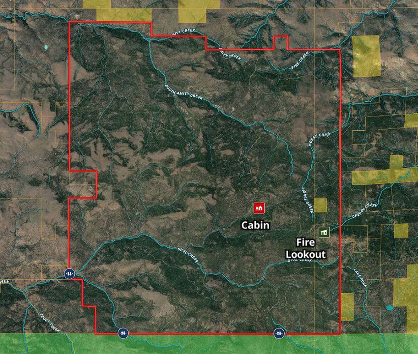
Summary
OPAL MOUNTAIN RANCH
±16,981 ACRES
$9,500,000
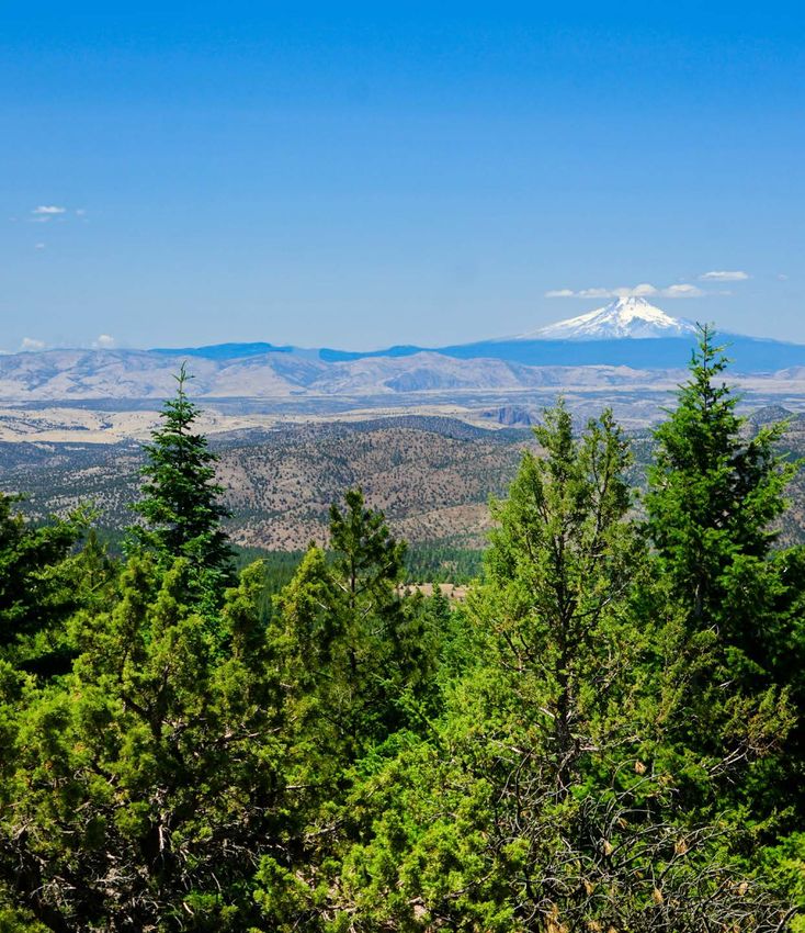
The Opal Mountain Ranch, located twenty-five miles north
east of Prineville, Oregon, is a legacy recreational timber ranch
consisting of approximately 16,981+/- deeded acres in a large
private block with exceptional wildlife, timber and water re-
sources. There are 17+ miles of streams and creeks that create
the headwaters of Trout Creek/Deschutes River and flow into
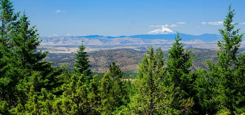
the John Day River. With Cascade Mountains views from Mt
Bachelor to Mt Rainier as its backdrop, the topography ranges
from timber covered slopes, grassy hillsides, steep canyons
and meadows. The ranch has an elevation range of 5,700 feet
down to 3,600 feet with over four miles bordering the Ochoco
National Forest allowing for diverse wildlife habit and abundant
recreation. The property is expected to generate attractive an-
nual positive cash flow from outfitting, conservation and car-
bon projects. Sustainable timber management and recreation
create significant long-term appreciation opportunities.
This prime investment is being offered at an attractive price
while providing tremendous value for recreational enthusi-
asts who seek a private retreat, stunning views, and abun-
dant wildlife with the benefit of a positive cash flow.
1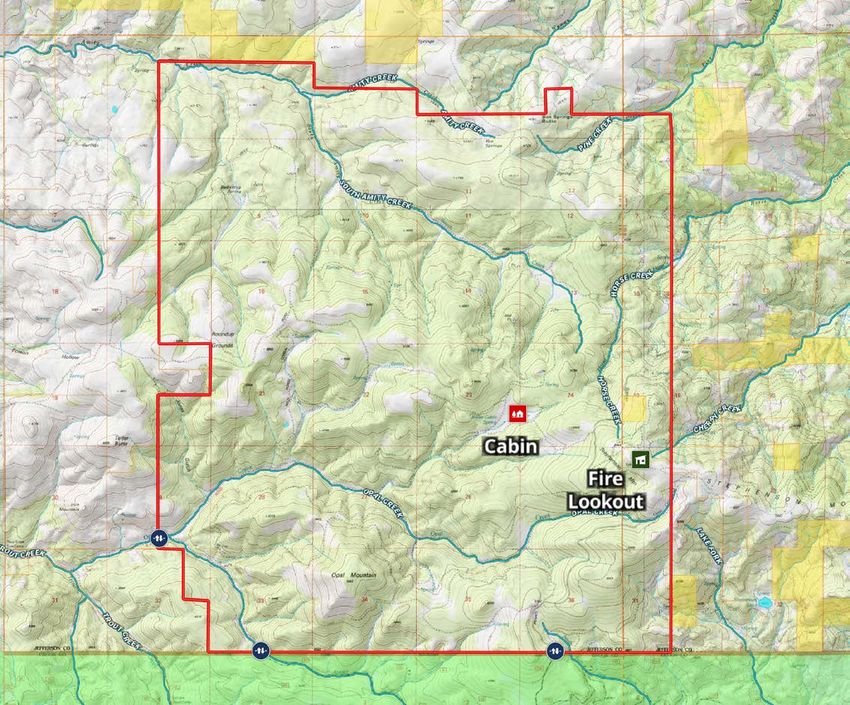
2
Location                                                           Zoning
    PRINEVILLE, OREGON                                                 PRIMARY FOREST USE

    The property is located within the southern portion of Jefferson   The subject is zoned Primary Forest Use by Jefferson County.
    County in Central Oregon. This area is located approximately       The purpose and intent of the Forest Management Zone is to
    25 miles northeast of Prineville, Oregon and approximately 65      provide for timber production, harvesting, and related activi-
    miles from Bend, Oregon.                                           ties, and to help protect timber areas from fire, pollution, and
                                                                       encroachment of non-forestry activities. This zone is also in-
    The property can be legally described by the Map and Tax Lots      tended to preserve and protect watersheds, scenic areas, and
    in Jefferson County:                                               wildlife habitats, and to provide for recreational opportunities
             T11S R18E Tax Lot 200 - 15,397.63 Acres                   and agriculture.
             T11S R19E Tax Lot 800 – 1,584.25 Acres

3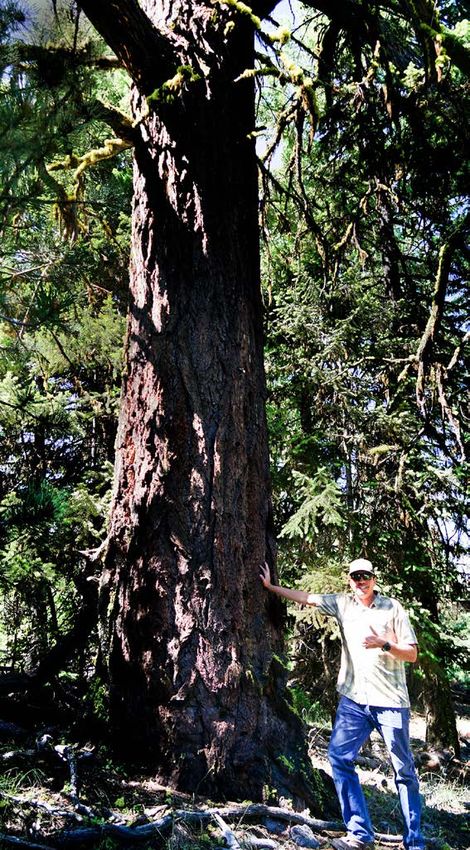
Acreage &
                                The property has a mixture of gentle rolling topography graduating
                                to steeper slopes along the southern boundary. The elevations range
                                from of about 3,600 feet to 5,700 feet at Stephenson Mountain. This
                                property is very private, with locked gates, and full of wildlife. Several
                                fish bearing streams run on the property including Opal Creek, Amity

Topography
                                Creek and Horse Creek. High mountain view points include Stephen-
                                son Mountain, Opal Mountain and Box Springs Butte.

                                              APPROXIMATE ACREAGE BY CATEGORY
                                 TIMBERLAND                14,298 AC

                                 RANGELAND                                            2,683 AC
ELEVATION: 3,600 — 5,700 FEET
                                 TOTAL                     16,981 AC

                                                                                                             4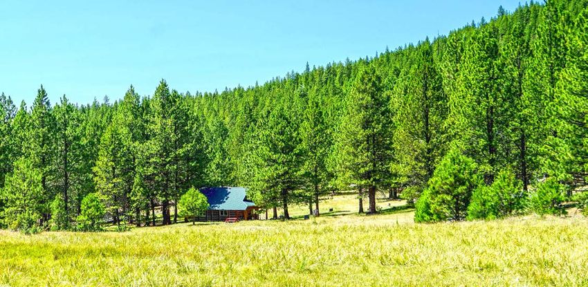
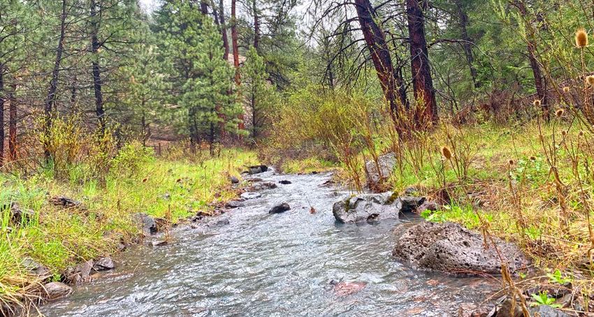
Water
    Resources
    SPRINGS & CREEKS

    The property includes over 17 miles of springs and creeks that
    provide abundant water for wildlife, fish and stock water. The
    three major fish bearing creeks, Amity, Opal and Auger Creeks
    are tributaries to Trout Creek which flows into the Deschutes
    River Basin. Horse Creek, in the northeastern corner of the prop-
    erty, is a tributary to the John Day River. Winter snow pack at
    the higher elevations provide annual recharge for all the springs
    and creeks.

5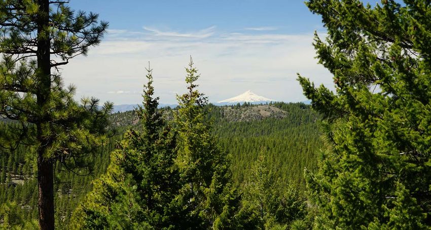
Recreational
Amenities
HUNTING, FISHING, HIKING, BIKING,
HORSEBACK RIDING, SKIING

This property is a premier private timber block, located in
the heart of the Ochoco Mountains, that also includes some
high mountain meadows and rolling rangeland teeming with
exceptional big game and upland bird species. In addition to
the premier hunting and fishing, the ranch provides abundant
opportunities for other recreation, such as snowmobiling,
cross-country skiing, horseback riding, four-wheeling, and bike
riding or hiking.

                                                                  6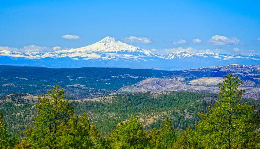
Hunting                                                                   Rocky Mountain elk, Mule deer,
                                                                                Pronghorn antelope, bear,
                                                                               cougar, wild turkey and quail
                                                                               are all found on the property
    PRIZED ACTIVITY YEAR ROUND

    Abundant wildlife can be seen in and around the streams, timbered       OPAL IS LOCATED IN THE GRIZZLY 38 HUNT UNIT
    canyons and wide open mountain meadows. Hunting remains a
    prized activity year round. Rocky Mountain elk, Mule deer, Prong-       2021 General Season:
    horn antelope, bear, cougar, pheasant, chukar, wild turkey and quail    Grizzly Archery - Bull Elk 8/28 to 9/26
    are all found on the property. The ranch qualifies for six mule deer
    buck and six bull elk landowner permits in the Grizzly Unit 38.         2021 Controlled Unit wide hunts:
    Big game hunting on the property is managed for trophy Rocky            Grizzly Unit (138) - Rifle Buck 10/2 to 10/13
    Mountain elk and Mule deer. Habitat and abundance of Mule deer          Grizzly Unit No. 1 (238X) - Rifle Bull Elk 10/27 to 10/31
    provide the opportunity for trophy class bucks. Elk hunts are           Grizzly Unit No. 2 (238Y) - Rifle Bull Elk 11/6 to 11/14
    unique because the ranch is in the main rutting area for the Ochoco
    Mountains.                                                              Grizzly Unit (438) - Buck Pronghorn 8/14 to 8/22

    This property has been leased to Centerfire Outfitters for over thir-   2021 Controlled Sub-unit hunts:
    ty years. Many of the hunting clients have been hunting for de-         Grizzly Private Lands No. 1 (238C1) - Rifle one Elk 10/27 to 10/31
    cades with the outfitter and return year after year due to the great
                                                                            Grizzly Private Lands No. 2 (238C2) - Rifle one Elk 11/6 to 11/14
    hunting.

7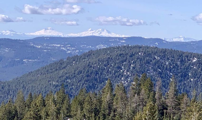
8
Timber
      PINE, FIR, JUNIPER & LARCH

      Opal Mountain Ranch is one of the largest, contiguous timber-
      land properties in close proximity to the cities of Prineville, Red-
      mond and Bend. The timberlands are predominately Ponderosa
      Pine, White Fir and Douglas Fir with smaller volumes of Juniper,
      Larch and other Pine. Over the years, the previous owners man-
      aged for recreation while only harvesting very limited timber.

                                                                                                                                                                                                       WESTERN LARCH
                                                                                                                                                                                             JUNIPER
                                                                                                                   PONDEROSA PINE

                                                                                                                                              DOUGLAS FIR
      Estimated net merchantable volume is 69,962 MBF (or 4,893

                                                                                                                                                                        GRAND FIR
      board feet per timbered acre) with an estimate annual growth
      of 2,400 MBF. The volume estimate was calculated using
      third-party inventory data collected in 2020.                                                                                                                   FINITE CARBON
                                                                                                                                                                        INVENTORY
                                                                                                       Area (Acres)                                                                 16,981
                                                                                                       Forested Acres                                                               14,298
                                                                                                       Stocking (Forested Acres, Avg BF/Acre)                                        4,893
                                                                                                       Merch Volume Estimate (MBF)                                                  69,962
                                                                                                       Estimated Annual Growth (MBF)                                                 2,400

                                                                                                       STOCKING BY SPP.
                                                                                                          Ponderosa Pine                                                             62%
                                                                                                          Douglas Fir                                                                23%
                                                                                                          Grand Fir                                                                  11%
                                                                                                          Juniper                                                                     4%
                                                                                                          Western Larch                                                               1%
                                                                                                          Merch Annual Growth Rate                                                  3.44%

                                                                                                       MERCHANTABLE SPECS (MINIMUM)
                                                                                                          DBH                                                                       None
                                                                                                          Ponderosa Pine Top End Diameter                                            6”
                                                                                                          All Other Timber Top End Diameter                                          5”
Disclaimer: Neither Seller nor any of Seller’s Representatives makes any express or implied representation or warranty as to the accuracy or completeness of the information provided, and no such
person will have any liability relating to the information or for any errors therein or omissions therefrom. You and your Representatives are not entitled to rely on the accuracy or completeness of the
information and will be entitled to rely solely on such representations and warranties as may be included in any definitive agreement with respect to the Transaction.

9
Conservation Climate
LAYERED CONSERVATION EASEMENT SEMI-ARID, HIGH DESERT
Opal Mountain’s steelhead-bearing streams and wildlife habitat Central Oregon is widely recognized as a tourist destination
in the Deschutes and John Day watersheds make it a strong in part because of its moderate climate, picturesque scenery
candidate for stream and riparian restoration, upland habitat and significant recreational amenities, and the property’s loca-
complexity, and wildlife management projects that will enhance tion on the Northern Slope of the Ochoco Mountains provides
the region’s native fish and wildlife populations. Conservation a semi-arid, high desert climate. Precipitation averages 10-15
can be focused on improved habit complexity for wildlife and inches with heavy snowfall at the upper elevations during win-
include projects ranging from enhanced timber management ter months. It is not unusual to have overcast conditions in
to mule deer habitat restoration. The owner is examining op- Portland and clear skies in the Prineville area. Scenic views to
portunities to secure public funding for these activities. Many rivers, buttes and mountain peaks are prevalent. This combina-
other opportunities exist for the owner to be compensated for tion of pleasant weather conditions and scenic views enables
ensuring the stewardship of their land and timber for years to all types of outdoor recreation available in Central Oregon.
come.
10Carbon
Project
HOW IT WORKS
As trees grow, forests capture carbon dioxide (CO2) from the
atmosphere and store them in trees’ roots and wood. Timber-
lands are a key carbon sink and play a pivotal role in slowing
down the accumulation of greenhouse gases in the atmo-
sphere.
Owners have made significant progress towards establishing
a carbon offset project at Opal Mountain Ranch. The carbon
project will create opportunities for ongoing sale of carbon
offsets under California’s greenhouse gas emissions reduction
market after the initial issuance of carbon offsets, which will be
retained by the current owners.
O2
CO2
C
11Carbon
Enrollment in the California carbon program brings valuable benefits
to a future buyer, but also imposes certain long-term management
requirements.
The carbon project allows for sustainable timber harvesting. As long
Benefits
as a landowner does not harvest more timber than the amount of
growth in a given year, harvesting is permitted. Thus, the landowner
can implement a range of silvicultural prescriptions that will generate
income and benefit the long-term health and value of the property.
Each year, the landowner can sell carbon offsets equal to the amount
of carbon sequestered that year by the trees on the property. Each
13,600 TONS OF CARBON = ±$136,000 offset is equivalent to one ton of sequestered carbon. If the landown-
er harvests no timber in a given year and, as a result, the growth of
trees on the property sequesters approximately 13,500 tons of addi-
Opal Mountain Ranch’s 2020 timber inventory indicated that the tional carbon, the landowner can sell approximately 13,500 offsets.
property’s timber and carbon stocking exceed regional averag- Offset prices have been in the $10-$15 range over the past few years.
es and should generate attractive annual cash flows through At only $10 per offset, the property could generate $136,000 each
carbon sales under regulations promulgated by the California year from the sale of 13,600 offsets representing estimated growth.
Air Resources Board. Opal Mountain Ranch has implemented By way of comparison, property taxes on Opal Mountain Ranch are
the steps (full carbon inventory, list project with a registry, etc.) approximately $41,000 in 2020.
necessary to finalize a carbon project on the property.
$$$
POTENTIAL SALES
TONS OF CARBON OFFSETS
$136,000
13,600 13,600 to $204,000
12Carbon Management
Requirements
CALIFORNIA AIR RESOURCES BOARD
The landowner can harvest timber at rates that do not exceed audit) and is not a major undertaking, if the landowner is not
the forest’s annual rate of growth. The landowner may not in- harvesting. Every six years, an inventory and field visit verifica-
tentionally cause the property’s carbon stock to drop. However, tion will be required.
unintentional losses of carbon (from wildfire, disease, etc.) are
not the responsibility of the landowner. The state of California The landowner must commit to sustainable long-term harvest-
has established a “buffer pool” of offsets by setting aside a por- ing practices. A common method of demonstrating this com
tion of all offsets generated by California carbon projects. This mitment is becoming certified under the Tree Farm System,
buffer pool is analogous to an insurance policy that protects Sustainable Forestry Initiative, or Forest Stewardship Council
the landowner in the event of a reduction in carbon stocking certification programs.
caused by factors outside the landowner’s control, such as The property may be subdivided and sold to multiple buyers if
wildfire or disease. In the event of such an “unintentional rever- all buyers agree to the carbon program restrictions.
sal,” the state will draw on the buffer pool to replace any lost
carbon offsets, and the landowner will be shielded from any The landowner must adopt a natural resource management
associated regulatory penalties. plan that satisfies the California requirements.
The landowner will need to submit annual reports to the The above is only a summary of the potential benefits and
third-party carbon “registry” responsible for the property. Most requirements of the program. For more information, please
landowners satisfy this obligation by hiring a carbon develop- see the detailed guidance available on the website of the Cal-
er, such as Finite Carbon, to perform the analysis and submit ifornia Air Resources Board at https://ww3.arb.ca.gov/cc/ca-
the reports. Reporting in most years is a paper exercise (desk pandtrade/offsets/offsets.htm.
13Improvements Sub-Surface
CABIN & FIRE LOOKOUT SUB-SURFACE (MINERAL) ESTATE
Hunting Cabin: A custom hand-hewn log hunting cabin is lo- All mineral rights appurtenant to the property and owned by the
cated on the property and is used by the hunting outfitter. The seller will convey to the buyer at closing. There is a Mineral Roy-
cabin sits on the edge of a meadow and is accessible by gravel alty of 50% interest in income from mineral extraction on the
road. Property. The buyer has absolute control over any exploration,
access, and development of these mineral rights.
Fire Lookout: The U.S, Forest Service operates a fire lookout
on the property, providing the best protection available for a
legacy timber property.
14Opal Mountain Ranch
PRICE: $9,500,000 DEEDED ACRES: ±16,981 PRICE PER ACRE: $560.00
HIGHLIGHTS
For more information, contact:
• 14,298 forested acres with a mixed conifer timber stands
• USFS fire lookout located on the property JAKE POLVI
• Mountain views from Mt. Bachelor to Mt. Rainier (541) 410-3050
jake@polvi.net
• 6 buck Mule Deer & 6 Rocky Mountain bull elk land-owner tags www.PolviRealEstate.com
• 8 creeks, some with mountain trout
• Large private block with no public roads or private in-holdings
• Annual income from sustainable forest management projects
Disclaimer: The information provided has been obtained from sources believed to be reliable and is believed to
be correct, but the project developers and brokers do not guarantee its accuracy. This information is subject to
errors and withdrawal without notice. All distances, sizes, capacities, and similar measurements and figures are
approximate. All information about properties should be independently verified by interested purchasers. Broker
is licensed in the state of Oregon.
15You can also read


