Nottingham's Police Stations - by Graham Woodward
←
→
Page content transcription
If your browser does not render page correctly, please read the page content below
Nottingham’s Police Stations
                                            by Graham Woodward

Today the police are located in large, central police stations, but at one time there was a station in almost
every district. By 1885, Nottingham had 15 police stations and a number of lodges spread across the town. A
few of these old stations are still standing, now used for different purposes with no hint of their earlier use.
This article looks at these sites, but first it is worth taking a moment to look at a brief history of the national
police force.

The first professional police force in Britain was set up in Glasgow in 1800. The police officers also had to do
other duties, such as fire-fighting. In 1829 in London, the Home Secretary, Sir Robert Peel, set up the first
English formal police force. They were nicknamed ‘Peelers’ or ‘Bobbies’ after his name. They were also called
‘Coppers’ after the old English term cop, ie. to get hold of something (cop-hold of him). Before 1829, most
parishes had their own constables and watchmen, but they were a volunteer force. The new professional
forces were organised into divisions with a central headquarters. Police officers wore blue uniforms to
distinguish them from military personnel, and their stove-pipe hats were strengthened with leather to protect
their heads. The stove-pipe hats were replaced in 1863 by custodian helmets, still in use today. They also
carried a truncheon and a rattle, but in the 1880s whistles replaced the rattles.

(Above) The blue lamp outside the old station on High Pavement, Nottingham.

The Municipal Corporations Act 1835 required the setting up of a Watch Committee to supervise the police.
The Rural Constabulary Act 1839 allowed police forces to be set up in rural areas, on the basis of one police
officer for every 1000 residents, and for each county to appoint a chief constable. Quite a few ignored the
change until the County and Borough Police Act 1856 made setting up a force compulsory in all areas.

The first Nottingham police force
On 7th May 1803, following several riots in the county during an election, a bill authorising the magistrates of
Nottinghamshire to, “interfere with the police of the town and county of the Town of Nottingham” received
royal assent. In this context, ‘Interfere with’ meant organise. Soon afterwards, a new regiment of Volunteer
Infantry was raised in Nottingham but in 1808 they were disbanded, and all the officers were transferred to
the Local Militia. Most of the town’s nightwatchmen were financed by shopkeepers and property owners, and
Nottingham had three constables, one for each parish (St Mary’s, St Nicholas’ and St Peter’s).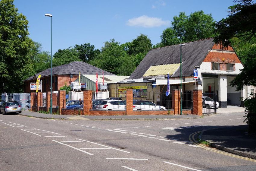
In March 1811, the Local Militia were deployed when riots by Luddites began. The Luddites were angry
because of the depressed state of the hosiery trade and because the stocking and hosiery manufacturers
changed their production method which increased output but at a lower price. This hit workers really hard
with the change coming on the back of rising food prices, especially bread. Over 4200 families in Nottingham
had to claim Poor Relief. In retaliation the Luddites ransacked hosiery factories and smashed frames. Police
from London’s Bow Street were drafted in to help quell the riots but by 1815 over 1,000 frames had been
destroyed. In 1823, £360 was spent on running costs for a Police Office in the Town Hall and in 1830 a Police
Office was established on Smithy Row, in the Exchange building (below).

In October 1831, a new reform bill designed to give ordinary people the right to vote and introduce modified
government was blocked in parliament by Bishops and Peers, and riots resulted. Upwards of 20,000 people
attended a public meeting in the Old Market Square to protest at the loss of the bill, but they later dispersed,
although special constables were sworn in and told to assemble in the Square if the bell on the Old Exchange
was rung. A mob smashed windows in Hockley, then attacked a windmill on the Forest and ransacked Colwick
Hall, setting it on fire, but it was saved. The next target was the Castle, the home of the Duke of Newcastle,
one of the main opponents of the Reform Bill. The mob set the Ducal Palace on fire, which was destroyed. A
couple of days later the Anglo-Scotian silk mill at Beeston was attacked and set on fire and the mob set off
towards Wollaton Hall but was repelled by the South Notts Yeomanry. After several more skirmishes in the
town the Special Constables regained the upper hand, but it was estimated that the damage to the Castle,
Colwick Hall and the Beeston mill amounted to over £50,000 (£5 million in today’s money).

In 1836, the Nottingham town police force was established consisting of three separate forces: Night Police,
Day Police and Evening Police. Nottinghamshire Constabulary was established in 1840. For many years there
were two separate forces, town and county. This was because in 1449 Nottingham was made a County
Borough, independent from the county. The town headquarters was in Smithy Row and the county
headquarters was at County House on High Pavement. The original town force was not very effective and in
1841 it was re-formed with 47 officers and a new, part-time Police Chief. (This was followed in 1851 by the
appointment of a full time Police Chief and in 1860 by a Chief Constable.)

In 1848, a new town station opened at St John’s Street, the section of road that is now part of Lower
Parliament Street between King Edward Street and Heathcote Street. The station stood next to the
Nottingham House of Correction on the corner of Glasshouse Street, built in 1615 as St John’s Hospital. It
originally belonging to the Knights of St John of Jerusalem but was later given to the town council and
converted into a prison about 1806 when a new wing was added. It was used mainly to relieve overcrowding
at the Guildhall on Weekday Cross and was for debtors and other non-felon prisoners. It was a target of the
Reform Act rioters in 1831, intending to release the prisoners to join the cause, but the Yeomanry decided to
protect the prison instead of the castle and managed to repel the mob. In 1861 the House of Correction
housed 97 prisoners with PC George Hopkinson as the resident police officer.
(Above) The Nottingham House of Correction, also known as St John’s Prison, St John’s Street.

The prison closed in 1889 and was demolished in 1891. It was replaced by a new prison on Perry Road, the site
of the current Nottingham Prison, remodelled in 1912. In 1901, the old site on Glasshouse Street was
redeveloped with the building of a skating rink; King Edward Street was built about the same time. On 1st
January 1913, the rink re-opened as the Picture Theatre (a cinema).

The two maps below, 1891 on the left and 1913 on the right, show the changes to the road layout (Millstone
Lane is now called Huntingdon Street). In 1922 the picture theatre became the Empress Picture House until it
closed in 1927 to be replaced in 1928 by the new Central Market housing the stalls moved from the Old
Market Square after the new council house was built. A replacement cinema, the New Empress, was built on St
Ann’s Well Road, opening on 29 October 1928.

By 1851 the town force had 61 officers (1 Superintendent, 2 Inspectors, 5 Sergeants and 53 Constables) to
cover a population of 58,000. The Chief Constable was Supt. William Reddish who was paid an annual salary of
£150 (£22,000 today) plus house and coal allowance.

In 1854, the first local CID (Criminal Investigation Department) was formed with a Superintendent and four
Constables.
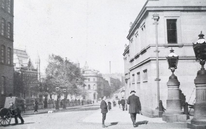
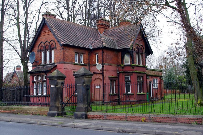
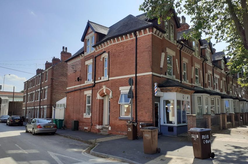
High Pavement County Police Station was next to County Hall and the police were also located in County
House on the opposite side of the road. The 1881 OS Map below shows the police station on the south side of
the road.

Very little is known about the old county police station. It was built in 1847 and Slater’s 1847 Directory shows
Thomas Whitworth as the Superintendent in charge. A small contingent of town police was based at the
station until the new town station opened at St John’s Street in 1848, and a few officers were based at the Old
Guildhall (Town Hall) at Weekday Cross.

The station and jail closed in 1878 after a report highlighted its appalling conditions. It was replaced in 1905 by
a new building (below) that is now Grade II listed, but the name of the architect is not recorded. It closed in
1986 and today is used as offices, but it still has the old blue lamp hanging outside.
(Above) The Old Guildhall (Town Hall) and Prison that stood on Weekday Cross.

The Old Guildhall (Town Hall) at Weekday Cross originally housed a small contingent of town police officers. It
also contained a jail. A 15th century building, it was remodelled in 1741 with a new roofline and a new façade
overhanging the footpath, supported on timber columns. In 1846 the jail was moved to the House of
Correction on St John’s Street. After the expansion of the town in 1877 the hall was deemed too small and
council meetings moved to the Mechanics Institute on Burton Street and later to the Old Exchange. In 1888
other civic bodies and the police moved to the new Guildhall, newly built on Burton Street. In 1894 the old hall
was acquired by the Gt Central Railway and demolished to make way for their new London Extension out of
Nottingham Victoria Station. The site is now that of the Nottingham Contemporary.

The 1860s
By 1862 the town police force’s strength had risen to 97 officers, located in 6 police stations scattered across
the town. These were on Leen Side (Canal Street), Mansfield Road, St John’s Street (Lower Parliament Street),
Smithy Row, Sneinton Road and Trent Bridge. The Trent Bridge station was on the east side of the River Trent,
in what is now West Bridgford, before the borough boundary was moved to the centre of the river.

                                                                                Leen Side Police Station is first
                                                                                mentioned in Wright’s 1862 directory,
                                                                                but it is not the one we see today on
                                                                                Canal Street that is now the London
                                                                                Road Framework centre. The original
                                                                                station is shown on the 1880 OS Map
                                                                                (left) and would now be in the middle
                                                                                of the London Road roundabout.

                                                                                The junction of what is now Canal
                                                                                Street and London Road was altered
                                                                                considerably in the 1970s when many
                                                                                of the buildings were demolished.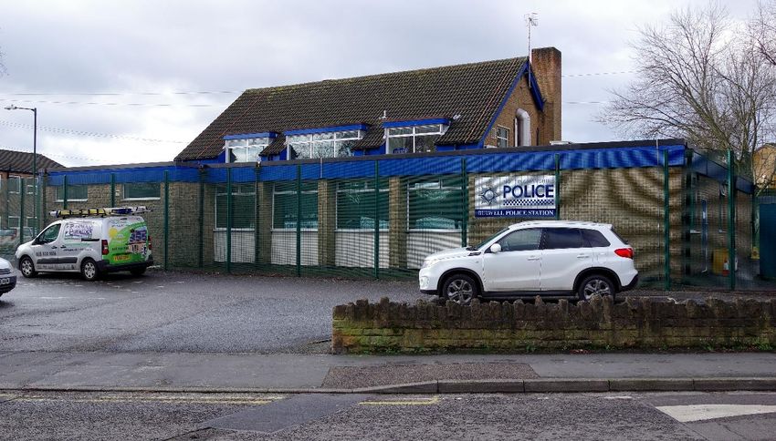
Mansfield Road Lodge (below) was built in 1857, designed by the architect Henry Moses Wood. In 1858 it
became a police lodge, first occupied by PC George Hopkinson. It remained a police lodge until the early 1880s.
It is now Grade II listed and used as a café.

Sneinton Road Police Station is perhaps the least obvious police station of them all. It was located in the
building that is now Tyre Zone (below). It is mentioned in Wright’s Directory of 1862 which records PC Thomas
Hallam as being ‘in residence’. This entry in the directory supports the theory that these buildings date from at
least the 1850s, as they are typical of buildings from that era.
Trent Bridge Lodge (below) opened in the late 1860s and is seen here in a picture dating from about 1875. It
shows the new Trent Bridge that opened in 1871, and the Town Arms pub can be seen in the background. The
police officer in front of the lodge is wearing the new custodian helmet introduced in London in 1863 to
replace the earlier stove-pipe hats and later adopted by all forces. When the picture above was taken in 1875
West Bridgford was only a small village with a population of 293 people in 55 houses; in 2011 the population
was 47,109.

The lodge is shown below on this extract of the 1899 OS Map. The 1967 OS Map (surveyed and revised
between 1952-64) also shows the building but not as a police station; it was demolished sometime around
1965.
The 1870s
By the mid-1870s, the police had six additional police lodges in the town: Bath Street Lodge (Sneinton),
Corporation Road Lodge (St Ann’s), Lammas or St Michael’s Lodge (Huntingdon Street), Meadow Lodge
(Queen’s Walk), St Ann’s Well Road Lodge (St Ann’s) and Woodborough Road Lodge (Mapperley Park).

Bath Street Lodge was on the corner of Bath Street and Robin Hood Street, Sneinton. The picture below from
1900 shows the old lodge on the left with a new substantial building on the right. The road on the right is
Robin Hood Street and the pub on the corner of Handle Street is the Bath Inn.

                                                                                  (Left) This picture dates from
                                                                                  1962 (copyright Reg Baker). Not
                                                                                  much seems to have
                                                                                  changed in 60 years apart
                                                                                  from a new doorway added
                                                                                  to the left of the main
                                                                                  building.

                                                                                  The station was replaced by
                                                                                  a new single storey building
                                                                                  on the same site that now
                                                                                  belongs to A.W. Lymn,
                                                                                  funeral directors.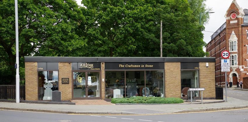
Corporation Road Lodge (St Ann’s) can be seen below in the centre of this composite map from 1881.
Corporation Road is the road heading south from the Police Lodge towards Hungerhill Road. The road heading
northwest up to Lavender Street was called Sycamore Road but is now part of Hungerhill Road.

In 1876, the lodge was manned by PC William Banshaw, who was said to be ‘in residence’. In 1894 it was
manned by PC Charles Sandall, and it was still there in 1904 when PC Thomas Edwin Hunt was in charge.

(Below) The old police lodge was where the green, corrugated building is now (A. & M. Motors). The building
on the right with the pointed end gable was built in 1904 as a Methodist New Connection Chapel. It is now the
Hungerhill Road Car Wash and Body Repair Centre.
Lammas Lodge, also known as St Michael’s Police Lodge, on Huntingdon Street, was built in 1860. In 1876 it
was recorded as having PC John Sills ‘in residence’.

The Lodge was on St. Michael's Street (or Curzon Place) which is now Huntingdon Street. It was situated on
former common land known as the Lammas Fields. The site later became the northern part of Huntingdon
Street Bus Station and afterwards was the site of Staples Office Supplies, now closed.

The lodge was built by Charles Edwards of London who won the commission as part of an architectural
competition to build a 'Lodge, Clock and Fountain'. It was demolished in 1975.
Meadow Lodge (below) (copyright G Oldfield) was on the southeast corner of Queen’s Walk and Kirke White Street
East in the Meadows district. In 1876 PC William Nicholson was in residence. In 1927 Queen’s Walk was
renamed Queen’s Drive but reverted to its original name in the 1970s. The lodge stood next to the former
Congregational Church, now a Pilgrim Church. A police station is shown on the site on the 1967 OS Map, but
that was a replacement building; it closed when the Meadows area was later redeveloped.

St Ann’s Well Road Lodge (below) as it was called in 1876, was on the corner of Coppice Road (now called
Ransom Road) and The Wells Road. In the picture, The Wells Road is on the right with Ransom Road on the
left. The station is shown on the 1881 OS Map and the plan view on the map fits the shape of this building,
suggesting that this is the original station. This post card is after 1904 when all trams had a roof fitted over the
top floor.
The picture below shows the policeman’s house on Ransom Road about 1964, awaiting demolition. The old St
Ann’s police station was to the right in the picture.

Woodborough Road Lodge stood somewhere between Vickers Street and Mapperley Road, in what was
described in 1876 as ‘Gorsey Close Gardens’. In 1876 the lodge was manned by PC Levi Pritchett who was also
in residence in 1881 with his wife and three young children. No pictures of the lodge are available, and it is not
clear on which side of the road it stood. The 1882 OS Map below shows the area where it was located, but it is
not marked on the map which suggests that it had closed. The 1885 records show that PC Pritchett was at the
lodge at Kirke White Street East in the Meadows, which fits with the closure of Woodborough Road lodge.
The 1880s
In 1877, the town boundaries were extended to take in Basford, Brewhouse Yard, Bulwell, Castle, Lenton,
North Wilford, Radford (including Hyson Green), Sneinton and The Park Estate, increasing the town’s area
from 1,996 acres to 10,935, with a total population of 157,000. The police soon realised that they needed
larger central premises and additional district police stations to manage the enlarged area.

During the 1880s, new stations were opened at Bobbersmill (Alfreton Road), Bulwell (Quarry Road), Hyson
Green (Gregory Boulevard), New Basford (Isandula Road) and New Radford (Ilkeston Road). Stations were also
opened at Wilford and Wollaton and although outside the city until 1952 and 1932 respectively, they have
been included here for completeness. In 1888, the City Police moved their HQ from St John’s Street to the
newly built Guildhall on Burton Street and South Sherwood Street.

The Guildhall (below) was designed by the architects Verity and Hunt and cost £97,000 to build. It had a suite
of apartments for the Town Clerk, Borough Engineer, Medical Officer of Health and Chief Constable. It also had
two magistrate’s courts, a ‘retiring room’, a grand jury room, 24 cells and a residence for 1 married police
officer. Twenty cottages on Shakespeare Row behind the new building were used to house police constables.

                                                      The 1899 OS Map on the left shows the site of the
                                                      Guildhall, which is still there today. The northern end of
                                                      the site fronting Shakespeare Street (shown as ‘Street’
                                                      on the map) and the western side of North Church
                                                      Street were redeveloped in the 1940s to provide a new
                                                      fire station and a new police station. The surrounding
                                                      area has also been redeveloped a number of times
                                                      since this map was produced: the Mechanic’s Institute
                                                      site has been redeveloped twice; Nottingham’s first
                                                      purpose built cinema, the Victoria Picture Palace (now
                                                      demolished), was built in 1910 facing Milton Street; and
                                                      the Tabernacle on the corner of Mansfield Road was
                                                      replaced in 1937 by a new YMCA building.
Fronting South Sherwood Street was the new police station and fire station (below) with access to an enclosed yard for vehicles etc. The site also housed 2 steam-powered fire engines, 2 manual ladder units and a mess room for 17 fire-fighters. It was built of Darley Dale stone with a slate roof and is now Grade II listed. On South Sherwood Street the police station was on the left (the round arched doorway was the public entrance). The cells were in the Guildhall which made transporting prisoners to court much easier. The fire station on the right is topped with a domed wooden bell turret housing a bell to summon the fire-fighters. (Below) The back of the building opened out onto a yard behind the Guildhall. According to ex Sgt. Peter Ludlow, the garage was used in the 1960s to store the Lord Mayor’s car (NTV 1) and the Sheriff’s car (NTV 2).
Bobbersmill Lodge opened about 1881 on Alfreton Road at the corner of Churchfield Lane. The extract from
the 1901 OS Map above shows the building highlighted by a red circle. In the 1881 census, the lodge was
recorded as being occupied by PC Thomas Bennett, aged 43, born in Buckingham. He lived at ‘the Police House’
with his wife, Maria aged 39, who came from Felsham, Suffolk. They had seven children. Wright’s Directory of
1885 shows Thomas as ‘in residence’, living on Churchfield Lane. By the 1891 census Thomas was dead, as it
shows Maria, a widow, living in Sherwood with five of her children, none of which were police officers.

In Wright’s Directory of 1894, PC John Marson is in situ with the property described as ‘Alfreton Road, 381,
Lodge’. It is not listed in the 1904 Directory, which implies that it had closed, although it is marked as a Police
Lodge on the 1920 OS Map. The site was redeveloped in the early 1930s; the Capitol Cinema (to the left)
opened in 1936 and the houses on the right were built about the same time. No pictures of the lodge can be
found. The vacant shop was once a sweet shop, then later a Hi-fi retail outlet and recently a recruitment
agency.
Bulwell Police Station, shown below on the right, opened in the 1880s on Quarry Road at its junction with
Coventry Road (where the horse is on the right). Quarry Road is now called Commercial Road and no trace of
the old station remains (the site is now vacant). The station also included a public lending library and a reading
room. The Red Lion Inn pub on the left behind where the man in the flat hat is standing was later rebuilt a
short distance down the road and is now, ironically, used as the current police station.

(Below) The original Red Lion Inn pub is shown in this picture from about 1901. The original police station was
behind where the photographer stood to take the photo.
Hyson Green Police Station (below) was built on the corner of Radford Road and Gregory Boulevard, soon
after the boulevard was built in 1883. The photo shows an early Nottingham Corporation Tramways electric
tram on Radford Road, purchased new in 1901. All trams were fitted with covered tops by 1904 which helps to
date the postcard. The station included a lending library until the new public library was built next door in
1896. The police officer on the right is standing near the front of what is now the Sharif & Sons supermarket.
The station was demolished in the late 1950s and replaced by a smaller building next to the library. That too
has now been demolished, replaced by a new station on the corner of Radford Road and Ward Street.

(Below) In the 1960s, the old Hyson Green police station was replaced by these shop units. The roof of the
replacement police station can just be seen above the wooden boarding to the right of the shops (copyright John
Sutton 2009).
(Below) Mansfield Road Police Lodge, Carrington, (copyright G Oldfield 1963) was originally the old Toll Bar office
after Mansfield Road was made into a turnpike road in 1787. It stood on the corner of Gregory Boulevard and
also housed fire-fighting apparatus. It replaced the Forest Lodge as the local police station about 1885.

The 1967 OS Map (below) shows a different police station on the site, set back from the road. The old Toll
House can still be seen next to the letter ‘A’ of Mansfield Road. The new station, similar in style to the one at
Canning Circus, was demolished when the Open University campus was built on the site of the former
Carrington railway station.
New Basford Police Station (below) was in a large house on the corner of Radford Road and Isandula Road. It
was also a fire station. In 1885 Sgt. J. Loverseed was ‘in residence’. It closed in 1970 after which it was used by
a vehicle repair company. It is currently a Sanctuary run by the Mary Magdalen Foundation.

New Radford Police Station (below) was on Ilkeston Road and is now a vets surgery. It was both a police
station and a fire station. In 1885 it was part of C-Division and was managed by Inspector John Foster and Sgt.
Thomas Bexon (Bexon retired in 1904). It closed before 1956; the picture was taken in 1980.
Wilford Police Station (below) was on Main Street opposite the Ferry Inn pub. It is now a private house. In
1885 it was manned by Sgt. James Iremonger who was also a drill instructor for the County Police. In 1881
James was aged 42, born in Botley, Hampshire. He occupied the station with his wife Naomi, aged 37, and his
two sons aged 15 and 13 years old. His wife came from Lincolnshire and his children were born in Yorkshire
and Notts, which shows how much police officers moved around even in those days. Wilford village did not
become part of the city until 1952.

                                                             The police at Wilford had to deal with a lot more
                                                             than petty crime. The nearby River Trent was a
                                                             dangerous river and Wilford ferry, which had
                                                             been in operation for over 400 years, had more
                                                             than its fair share of accidents and disasters. The
                                                             Gazebo (left) in St Wilfred’s Churchyard, built in
                                                             1752, was later used as a makeshift mortuary
                                                             for the numerous bodies fished out of the river,
                                                             usually by the local police. The Gazebo is now a
                                                             Grade II listed building and has recently been
                                                             renovated.

                                                             The ferry service closed in 1864 and a
                                                             temporary wooden bridge was built in its place
                                                             until Clifton Toll Bridge opened in 1870. The toll
                                                             bridge was paid for by Sir Robert Juckes Clifton
                                                             whose statue stands on the embankment.

                                                             Sir Robert Clifton built the bridge mainly to
                                                             transport coal over the river from his nearby
                                                             colliery, but he also took the credit for having
                                                             provided a safe crossing for the public, albeit at
                                                             a small toll charge.
Wollaton Police Station is not mentioned until the 1881 census. In the 1861 census the village is recorded as
having a nightwatchman in residence, John Moult, age 42, born in Wollaton, who lived with his wife Ann.
There is no mention in the 1871 census of a police constable or nightwatchman, but the 1881 census and the
1885 trade directory record PC George Steemson, age 49, from Oxton, Notts, ‘in residence’, living with his wife
and three children. He transferred to Wollaton from Blyth, Notts – before that he was a PC at Chilwell, Notts.
The station was located in the right-hand cottage (below) next to the church; the left-hand cottage was a Co-
op grocery store. The whole block of three cottages is now Grade II listed. In 1881 the village had a population
of only 712, hence the need for only one police officer.
The cottages were built about 1700 and the building may once have been a barn. It has coped gables and
Kneelers, typical of early brick-built Nottinghamshire farmhouses and farm buildings, although they were often
also used on grander buildings.
By 1891, PC George Steemson had retired, and the village constable was William Bishop, aged 26, born at
Carlton on Trent who lived with his wife and three children. George Steemson remained in Wollaton until his
wife died in 1908 and he then moved to Harrow to live with his daughter and son in law. He died in 1913 and
was buried at Wollaton. By 1901 Fred Clarke was the resident PC, born in Cotgrave, Notts, who lived with his
wife and two children, and in 1911 yet another constable was in charge, PC George Marshall, age 44, from
Worksop, living with his wife and four children. Wollaton became part of Nottingham City on 1st April 1933. A
photograph of the cottage taken in 1966 shows that it was no longer a police station.
A replacement station (left) (copyright Reg
Baker) was built on Wollaton Road,
opposite Old Coach Road, sometime
after 1964.
The car on the right is a Mk3 Ford Escort.
For many years police cars were black –
the Nottingham force received their first
all-white cars in 1963.
In 2013 the new station became a
funeral parlour, belonging to A.W. Lymn.The 1890s Wright’s Directory of October 1894 (below) shows details of the police force in Nottingham City. It lists the four divisions: A, B, C & D, their locations and staff details.
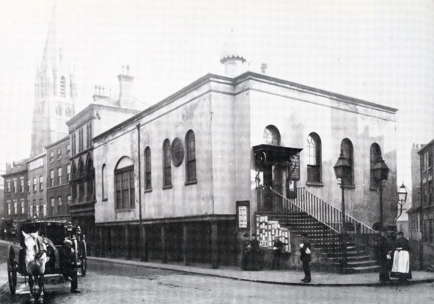
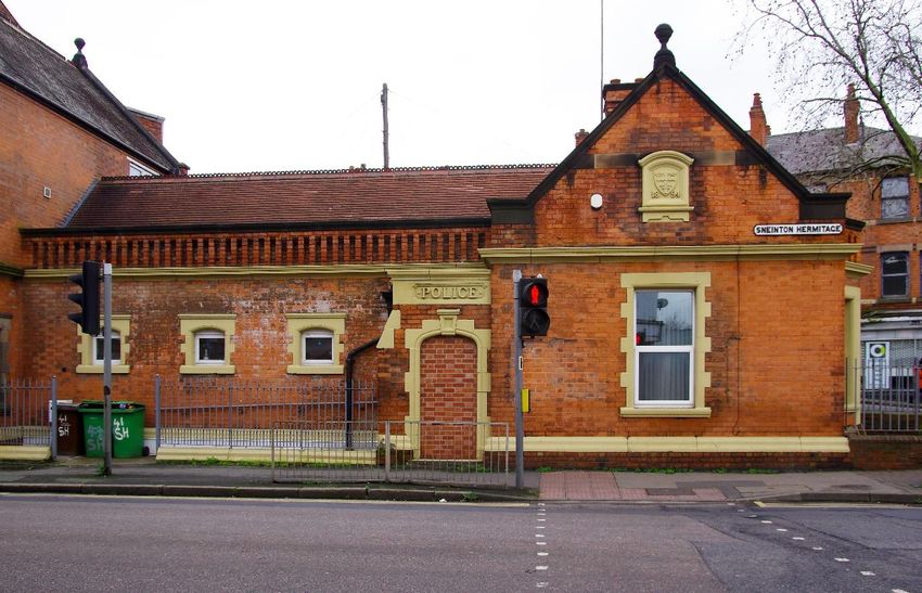
Sneinton Police Station (below) was built in 1894 on the corner of Sneinton Hermitage and St. Stephens Road.
It was also a fire station and later an ambulance depot. It has a date plaque showing 1894, but it is not
mentioned in Wright’s Directory of October 1894 so must have opened after it was written. In 1904 the officer
in charge was Sgt. John T. Cant, who moved to the station from Bulwell.

The station was still in use as late as 1976 but then closed and stood empty for a while. In 1996, permission
was granted to convert the building into residential accommodation. Sadly, it has had UPVC windows installed
and the main entranced has been bricked-up in a very unsympathetic manner. To be fair, the builders at least
used the same brick bond pattern, Flemish Bond, as the original building, but it is a shame that they didn’t just
install a false door to retain the aesthetics of the building.
The 1900s onwards
By 1901 the population of Nottingham had reached 240,000. In the city, constables walked the beat and in
rural areas they used bicycles - police cars were not introduced until the end of the 1920s.

(Above) This picture from 1900 shows the entrance on South Sherwood Street to the police station and fire
station at the new Guildhall. The large pillars, topped by huge lamps, are no longer in place. The junction of
Shakespeare Street and North Sherwood Street can be seen in the background.

(Below) From 1904 to 1910 this house at 311 Castle Boulevard was used as a police station with Sgt. Philip
Shotbolt in charge.
Leen Side Police Station (Canal Street) was built between 1901 and 1904. The new station is not shown on the
1901 OS Map but is listed in Kelly’s Directory 1904 and shown on the 1915 OS Map with the road still called
Leen Side and the old station now demolished. The new station was one of the largest built, housing at least
10 police officers and having a public mortuary and a fire station next door.

Some web sites attribute this building to Watson Fothergill, but there is no evidence to support this theory. In
fact, it is only the presence of the tower that invokes Fothergill links, but he used slated conical spires as caps
on his towers, not Ogee style caps as on this building. The building also has no Gothic features or date plaque
that is so typical of his style. It is not mentioned in Darren Turner’s definitive book on Fothergill. The buildings
on the far left were demolished when London Road junction was remodelled in the late 1960s. (Picture below –
copyright Nottingham City Council.)
Woodborough Road Police Station opened about 1904 opposite Porchester Road in the former Waterworks
Offices built in 1890; PC Hinman Whittaker was ‘in residence’. In 1910, Sgt. R. Parkes was in charge. According
to the 1968 OS Map it was still a police station in 1967 when the map was last revised.

In 1923, Police Cabins were introduced. The one shown below was of the ‘Garden Shed’ design and stood at
the western end of the Ropewalk, Canning Circus (copyright George L Roberts).

The new police cabins contained a telephone that was located behind a hinged door so it could be used from
outside the cabin. The interior of the box was like a miniature police station, used by police officers to write
reports, take meal breaks and temporarily hold detainees until transport arrived. They also contained a stool,
an electric heater, an incident book, a fire extinguisher and a first aid kit. The telephone linked directly to the
local police station, allowing officers on the beat to keep in contact with the station or request help. Most
cabins had an electric bell that rang to attract attention. The cabins were usually painted blue.
(Above Left) Police Boxes were used on sites too narrow for a cabin. Some forces used their own style boxes,
such as this one that stood at the bottom of Market Street, outside Yates’ Wine Lodge. Most had a blue lamp
on the top to attract the attention of a police officer. This box was later moved to Police HQ at Sherwood
Lodge. (Above right) Police Telephone Posts were introduced in 1930. They were about five feet (1.5m) high.
This Type-One version stood on Victoria Embankment near Trent Bridge. It had a bell on top so that the ringing
phone could be heard some distance away; some had a blue lamp instead. (Below) This cabin was on King
Edward Street (St Ann’s Well Road is to the right). Cabins and police boxes were withdrawn in the 1970s when
police officers were issued with personal radios.
In 1930, Nottingham City Police were the first force to introduce a forensic lab and the first to introduce patrol
cars with radios. In 1933 they were the first to introduce three-position photographs of criminals (left, front
face, and right), a system that was soon adopted internationally. The first female constables were recruited in
1946 but women were not allowed to be Specials until 1966.

Modern Stations
After World War Two there was a move away from the old Victorian and Edwardian stations, which were not
ideally suited to modern policing. They were no longer big enough and usually did not have any car parking
facilities.

(Above) Between 1938 and 1940, a new city police station was erected on the corner of North Church Street,
and a new fire station was built facing Shakespeare Street. The cottages in Shakespeare Row, that originally
housed police officers, were demolished. The station became the headquarters of the city force until it closed
in 2016. In May 2020, an application was made to convert the Guildhall into a hotel, gymnasium and spa.
Permission was also sought to demolish the old fire station and police station and build two new extensions
fronting Shakespeare Street, one 5-storeys high and one 13-storeys high. The application was approved but
today, 2021, all the buildings are empty, and the work has not yet started.

Across the road on Shakespeare Street the police built a multi-storey garage to maintain the police vehicles. It
had a rear access onto Peachey Street off Mansfield Road. In 2012 an application was made by Guildhouse UK
Limited, London architects, to redevelop the site and Cymbeline House was built comprising 44 student flats, 2
shop units and a Tesco Express supermarket.

The British Transport Police, a separate force, opened a police station on Queen’s Road in the former Midland
Railway’s Passenger Offices next to Midland Station. It is still staffed today.

In 1953, Epperstone Manor became the Nottinghamshire headquarters and in 1968 the county and city forces
merged to form the Combined Constabulary, later called Nottinghamshire Police. The present headquarters at
Sherwood Lodge opened in 1972 and was fully occupied by 1979.
Pemberton Street Police Station (below) (copyright Reg Baker) replaced the old station on Canal Street sometime
in the 1950s and was always called Canal Street Police Station despite its actual location on Pemberton Street.
The plain style of the new building, seen here in 1975, was typical of the functional buildings erected after the
war. The station closed in November 1975 and the officers were moved to Station Street. The building then
became a traffic-signal maintenance depot until 1988 when it changed again to commercial offices and a
showroom. It was demolished sometime before 2008 and the site is currently vacant.

(Below) Bath Street Police Station was replaced about 1963 by this new building, but it had closed by 1986. It
then became Ernest Smith’s Monumental Masons before being taken over by A.W. Lymn, funeral directors.
Arthur William Lymn began his funeral service on Bath Street in 1907 and the firm also had premises on
Sneinton Street. It is still a family owned business and they have the largest Rolls Royce funeral fleet in the
world – 9 hearses and 27 cars.
Ransom Road Police Station (below) was built in the early 1960s next door to where the old station stood at
the junction of The Wells Road, St Ann’s Well Road and Ransom Road. It is no longer a police station and in
2010 permission was granted to convert the building into a multiple-occupancy dwelling for seven tenants.

(Below) St Ann’s Well Road Police Station was built in 2006 near the corner of Robin Hood’s Chase. It cost
£720,000 to build and is on the site of the former Welcome Inn pub.

Hucknall Road Police Station, Carrington - According to the 1986 edition of the Geographers’ A-Z Map of
Nottingham there was a police station on the west side of Hucknall Road between Hamilton Road and
Alexandra Street, but the site is now a Texaco petrol station, and no early photos are available.
Sneinton Dale Police Station (copyright Reg Baker) was built sometime after 1976 - ex Sgt. Peter Ludlow who
worked Sneinton until 1976 tells me that he did not remember the new station being open before then. The
new single-storey station (above) was built on the site of the bridge carrying the former Nottingham Suburban
Railway over the road.

In 2004, Sneinton Dale Station was demolished and replaced by a new station (below), a two-storey enlarged
building designed by Focus Consultants (UK) Ltd, Nottingham. It closed in 2016 and is now the Dales Centre,
opened in May 2017 by Nottingham City Council; it also houses Sneinton Library.
Meadows Way Police Station (above) opened in the 1980s opposite Enterprise Way (copyright M Edwards). It was
formerly the site of the Spinning Jenny pub. The station closed in 2015 and was demolished in 2019. Two
blocks containing in total 21, 2-bedroom apartments are now being built on the site.

After Meadows Way station closed the police moved to the station on Rennie Hogg Road (below), to the west
of Queen’s Drive. The station does not have public access.

Dunkirk Police Station – this stood next to the fire station at the junction of Abbey Street and Clifton
Boulevard. It was built sometime in the late 1960s and only had access from Warwick Street behind the fire
station and wasn’t open to the public. The site has now been redeveloped and no pictures are available.
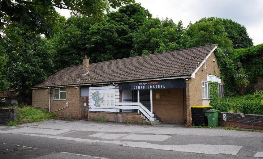
(Above) Church Lane Police Station, Bulwell, replaced the one on Quarry Road sometime after 1967. St Mary’s
Church is behind the station which closed in 2003.

(Below) Bulwell Police Station is now on Gilead Street at Bulwell. It occupies the former re-built Red Lion pub,
later called the Sporting Chance. The station opened in 2003 but there is no public counter or access.

Bulwell Police Station is named Ged Walker House after a local PC who was killed whilst on duty in 2003. He
was dragged to his death as he tried to arrest the driver of a stolen taxi. Local Bulwell resident David Parfitt
was later sentenced to 13 years for manslaughter.
(Above) Radford Road Police Station in Hyson Green was built in 1985. It replaced a station next to the library
on Gregory Boulevard, built in the early 1960s to replace the Victorian station on the corner of Radford Road.

(Below) Oxclose Lane Police Station, Bestwood, is another of the new large stations, one of only eight now in
the city. It is only just inside the city boundary and was built in 1990. It is a base for police officers only and is
not open to the public.
(Above) Green Lane Police Station at Clifton opened soon after the estate was completed in the early 1960s. It
is currently the Little Toes Day Nursery.

(Below) Clifton’s current station is on Farnborough Road.
Broxtowe Police Station (above and below) is on Strelley Road. It opened about 1966; the picture above dates
from 1985 (copyright Reg Baker). Like several other stations it is a base for police officers only and does not have a
public counter.
(Above) Canning Circus Police Station on Derby Road, built sometime after 1968, is still standing but is no
longer a police station. In 2011 it was the target of an attack by a mob wielding petrol bombs. Nottinghamshire
Live reported the incident as follows:

“The fatal shooting by police of Mark Duggan in Tottenham on 4th August 2011, led to the worst rioting in
Nottingham for at least a generation. Cars were set alight in Basford, Radford and Mapperley but the most
terrifying incident was when a mob targeted Canning Circus police station. A court was later told the attack
had been carefully planned, with some individuals acting as 'recruiting officers' to get as many people as
possible involved; text messages sent out beforehand and petrol bombs made in advance. The group, some
wearing disguises and armed with weapons, headed towards the police station. Petrol bombs were hurled at
the building, setting the front canopy on fire. The station continued to be attacked after the fire was put out.
The mob retreated but were contained by police, who responded in riot gear and with police dogs. After more
than 100 arrests, many of those arrested were under the age of 18.”

In May 2012, 16 people were sentenced to up to 12 years in custody for their role in the attack.

                                                                                 (Left) Plans have been
                                                                                 approved to demolish the
                                                                                 station and erect a five-storey
                                                                                 block containing eight
                                                                                 apartments for private sale.

                                                                                 The artist’s impression (left)
                                                                                 shows the planned new
                                                                                 building (copyright Nottingham
                                                                                 Post).
Bar Lane Police Station (above) (copyright Reg Baker) was near the Commodore International Centre. It is seen here in 1973 but it closed before 1986 and has since been demolished. One suggestion is that it replaced a police post on Melbourne Road on the southwest side of Nuthall Road. No pictures of the building at street level can be found but an aerial photograph (below) sent to me by ‘Cliff Ton’ at Nottstalgia.com shows the station (red arrow). It was still a police station as late as 1965. The Commodore is the large building on the right with Aspley Library on the opposite side of Nuthall Road.
Sherwood Police Station (copyright reserved) was in part of this former Lloyds Bank building at 621 Mansfield
Road, seen here in 2007; it was the part to the right of the black door. The building was erected in 1929,
designed by the architect A.J. Thraves. The police station closed in 2011 and moved to a mini-station further
down the road.

(Above) The police moved their presence in Sherwood to this Local Information and Neighbourhood Watch
enquiry centre on Mansfield Road between Daybrook Street and Newstead Street. This Google image was
provided by Stuart.C on Nottstalgia.com and is dated July 2008. By 2014 it was called Sherwood Police Point,
but it is now a shop, the Sherwood Workshop. There is some confusion over the precise street number –
Google Maps shows 579A but the website for the Sherwood Workshops states it to be at number 581A.
(Above) This Google image of the mini-station at 506 Mansfield Road beneath Sherwood Library is the only
picture I can find, as the whole site has been fenced-off in preparation for the building of a new library
complex on the site. Apparently, the site did not have any public access, just a buzzer to call for police
assistance.

(Above) Byron House on Park Row and Maid Marian Way is the current central police station in the city.

By April 2021, Nottinghamshire Police had a strength of 2,224 Officers for a population of 1.16 million
residents.
(Above) Bridewell Police Station is probably the most inaccessible police station in the city unless you are under arrest. It is on Castle Meadow Road, although the official police address is Carrington Street. It is primarily a custody suite for the adjoining magistrates’ court and therefore has no public access, hence the Google Earth picture. It opened about 1996 but is soon to be replaced by a new £17m custody suite at New Basford on the site of the old Basford Gas Works. The unit at Castle Meadow is destined to be converted into student accommodation. Graham Woodward July 2021. Email: gwoodward@clara.co.uk. See also http://www.gwoodward.co.uk/nottm.html for more history guides to Nottingham. Version 2.0 (revised 27 July 2021). My thanks go to ex-Sgt. Peter Ludlow for his information about the dates of some of the modern stations. Copyright Unless otherwise stated, all of the colour photos in this article were taken by me – the other pictures have been sourced from online sites and have been included solely for historic reasons, not commercial gain or profit. I have credited those pictures where copyright is known, but if I have offended anyone’s copyright I apologise and on request will credit the pictures accordingly. Bibliography British Census Returns 1841-1911 – Ancestry.com. Geographers’ A-Z Street Atlas of Nottingham 1986. Kelly’s Directory 1904. National Library of Scotland – online historic OS maps 1855-1952 (maps.nls.uk). Nottingham; Settlement to City – Duncan Gray 1953. Nottinghamshire History – online resource (nottshistory.org.uk). Nottingham Heritage Gateway; Police and Policing – Dr Denise Amos. Nottinghamshire Police; Our History – online resource (Nottinghamshire.police.uk). Nottinghamshire Police; Estates Strategy 2017-2021 – online document Nottstalgia.com – online forum. Slater’s Directory 1847. Wright’s Directories 1832-1915.
You can also read