Mountain Building at a Convergent Plate Tectonic Boundary: The Southern Adelaide Fold Belt
←
→
Page content transcription
If your browser does not render page correctly, please read the page content below
CASE STUDY 1.005
    Mountain Building at a Convergent Plate Tectonic
      Boundary: The Southern Adelaide Fold Belt
                                                          Author: Steve Abbott*

Introduction
Mountain belts are zones of lithosphere thickening along the boundaries between colliding tectonic plates. Examples of modern
mountain belts include the European Alps, Andes, Himalayas and the PNG Highlands. Mountain belts are characterised by rock
deformation (i.e. folding and faulting), regional metamorphism, and igneous intrusions. When plate tectonic collision ceases
mountain belts become incorporated into the stable continental lithosphere and are called fold belts. Ore deposits are formed by
the circulation of mineral-bearing hydrothermal fluids. Such fluids are generated during mountain building by the heat associated
with metamorphism and igneous activity.

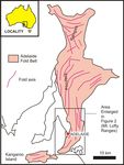
The Adelaide Fold Belt (Figure 1) is an example of an ancient mountain belt that was active over a 24 million year period during the
late Cambrian to earliest Ordovician Periods. The mountains subsequently eroded away and their remnants are now exposed in the
Flinders Ranges, Mount Lofty Ranges, and Kangaroo Island. The southern part of the Adelaide Fold Belt, exposed in the Mount Lofty
Ranges, provides an excellent case-study for mountain building because changes in rock deformation, metamorphism and igneous
activity can be mapped between the outer fold belt and its inner core. Numerous mineral deposits have been found in the southern
Adelaide Fold Belt and several of these have been mined.

                 Figure 1. Location of the Adelaide Fold Belt in the Mount Lofty Ranges, Flinders Ranges, and Kangaroo Island.

       This case study was prepared to complement Exploring Earth and Environmental Science.
       For more information about this textbook visit www.earthsciencewa.com.au
Main content
Figure 2. Simplified geological map of the Mount Lofty Ranges showing key features of the southern Adelaide Fold Belt.
Figure 2 is a simplified map of the Adelaide Fold Belt exposed at the surface of the earth in the Mount Lofty Ranges. The map
highlights folds, faults, metamorphic zones, and igneous intrusions. Along the western, outer part of the fold belt, the rocks are
folded and faulted, but are only slightly metamorphosed as indicated by the presence of the mineral chlorite. This part the fold belt
is exposed in Sleeps Hill quarries (Figure 3). There, folds in quartzite and mudstone are up to several hundred metres across.
Figure 3. Large folds exposed in Sleeps Hill Quarries (see Figure 2 for location). Two quartzite units (shaded) have been mapped in and between the
quarries. The poorly exposed rocks between the quartzite units are dominated by mudstone. Anticlines and synclines are indicated by geological
symbols. The field of view is approximately 1,000 m across.
ADELAIDE FOLD BELT TECTONICS PAGE 2Further east toward the core of the fold belt, the progressive appearance of the metamorphic minerals biotite, staurolite,
andalusite, and sillimanite reflect an increase in temperature and pressure i.e. metamorphic grade. Mudstone is now replaced by
the metamorphic rocks phyllite, schist, and gneiss. The highest grade of metamorphic rock in the Adelaide Fold Belt is found in the
migmatite zone. Migmatite is a coarse-grained metamorphic rock which forms when the metamorphic temperature is so high that
the rock partially melts.
The core of the Adelaide Fold Belt is intruded by granite and similar igneous rocks collectively referred to as granitoids.
Geochemical studies indicate that these igneous rocks originated mainly from partial melting of the mantle. They then migrated up
into the core of the fold belt. Geochemistry of some of the granitioids indicates that surrounding fold belt rock was melted and
incorporated into the magma. Depths of granitoid emplacement were 5-10 km below the Earth’s surface.
Figure 4. The boundary between the Palmer Granite and migmatite is well exposed in the bed of Reedy Creek (see Figure 2 for location). The Reedy Creek
area is within the core of the Adelaide Fold Belt where granite bodies intrude high grade metamorphic rocks. The arrow indicates the location of Figure 5.
Figure 5. Close-up of the boundary between the Palmer Granite and migmatite. Partial melting is indicated by the contorted nature of the dark and light
banding in the migmatite (examples arrowed) and the complex mixing of granite and migmatite along the boundary between these two rock types.
ADELAIDE FOLD BELT TECTONICS PAGE 3The boundary between the Palmer Granite and the surrounding migmatite is exposed in the bed of Reedy Creek (Figure 4). The
migmatite has a banded appearance and contortions in the banding are evidence of its partially molten state (Figure 5). The
progression to complete melting and incorporation into the granitiod magma is indicated by the intermingled boundary between
these two rock types (Figure 5).
The heat associated with igneous activity and metamorphism results in the circulation of hydrothermal fluid. Chemical elements
sourced from granitoids and other mountain belt rocks are incorporated into the circulating mineral-bearing fluids. Changes in physical
and chemical conditions (e.g. decrease in temperature and pressure) can cause minerals, including metals and metal-bearing minerals,
to precipitate. There are many deposits of copper, gold, zinc, lead, and silver in the Mount Lofty Ranges. Deposits that have been mined
include Kapunda (copper), Kanmantoo (copper-gold), Angas (zinc-silver-lead), and Bird-in-Hand (gold) (Figure 2).
A plate tectonic explanation for the formation of the Adelaide Fold Belt has been provided by research geologists. Prior to about 514
million years ago the sedimentary basin known as the Adelaide Geosyncline was located along the south-east coast of Gondwana.
About 514 million years ago subduction of oceanic lithosphere commenced that resulted in a change from a passive continental
margin to a convergent plate tectonic boundary. Sedimentation in the Adelaide Geosyncline stopped, and mountain building
processes commenced, in response to the convergent ('pushing together') plate tectonic forces. Radiometric dating of granitoids,
which were emplaced during mounting building, indicates that mountain building continued for about 24 million years until 490
million years ago. The complexity of rock deformation and the intensity of metamorphism increased towards the deep core of the
mountain belt. The core of the fold belt was intruded by granitoids. The overlying mountains were likely to have resembled a
modern fold belt.
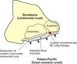
Figure 6. Plate tectonic reconstruction of Gondwana during formation of Adelaide-Ross Fold Belt (c. 514-490 million years ago). The outlines of
Australia and Antarctica at this time are indicated.
A plate tectonic reconstruction (Figure 6) shows the position of Australia and Antarctica within the ancient super-continent of
Gondwana. The Adelaide Fold Belt and its Antarctic counterpart, the Ross Fold Belt, are located along the south-east coast of
Gondwana inboard of a subduction zone and overlooking the proto-Pacific Ocean. After mountain building ended, fragments of
continental crust and a number of younger fold belts have been added to the eastern margin of Australia. Australia broke away
from Antarctica about 56 million years ago during the breakup of Gondwana.
References:
Drew, G. 1997. Hallett Cove Geological Trail. MESA Journal, 4, 32-33.
Drew, G. 2000. The Sleeps Hill Quarries Historic site. MESA Journal, 17, 34-36.
Foden, J, Elburg, MA, Dougherty-Page, J. and Burtt, A. 2006. The Timing and Duration of the Delamerian Orogeny: Correlation with the Ross Orogen
and Implications for Gondwana Assembly. The Journal of Geology, 114, 189–210.
Gravestock, DI. 1995. Chapter 7 Early and Middle Palaeozoic. In: Drexel, JF and Priess, WV. (Editors). The Geology of South Australia Volume 2, The
Phanerozoic. South Australia Geological Survey Bulletin, 54.
*Steve Abbott is a geologist with considerable experience in academic research, undergraduate teaching, geological mapping and
industry exploration with particular expertise in basin analysis and sedimentology.
www.tesep.org.au
ADELAIDE FOLD BELT TECTONICS PAGE 4CASE STUDY 1.005 / STUDENT ACTIVITY
Mountain Building at a Convergent Plate Tectonic
Boundary: The Southern Adelaide Fold Belt
Author: Steve Abbott
Suggested Activities
1. Fold structures in the Adelaide Fold Belt are well exposed at Hallett Cove near Adelaide (Figure 7).
a. On the photograph, draw lines along the folded bedding to define the shape of the folds. Some lines have been completed
as a guide.
b. Using Figure 3 as a guide, draw fold axes. Use the appropriate symbol to distinguish between anticlines and synclines.
Figure 7. Folds exposed in the wave-cut platform at Hallett Cove (see Figure 2 for location). The photograph was taken from the top of a cliff. The
people at right of centre indicate scale.
2. Study the cross-section of the Adelaide Fold Belt (Figure 8). Using the words from the “label list”, write labels in the boxes to
highlight the various components of a fold belt.
ADELAIDE FOLD BELT TECTONICS PAGE 5Figure 8. Cross-section across the southern Adelaide Fold Belt. The location of the cross-section is indicated in Figure 2.
www.tesep.org.au
ADELAIDE FOLD BELT TECTONICS PAGE 6You can also read


