Limits in the Seas No. 150 People's Republic of China: United States Department of State - State ...
←
→
Page content transcription
If your browser does not render page correctly, please read the page content below
United States Department of State
Bureau of Oceans and International
Environmental and Scientific Affairs

Limits in the Seas
No. 150

People’s Republic of China:
Maritime Claims in the South China Sea
LIMITS IN THE SEAS

                                          No. 150

                      People’s Republic of China:
                Maritime Claims in the South China Sea

                                      January 2022

                    Office of Ocean and Polar Affairs
  Bureau of Oceans and International Environmental and Scientific Affairs
                        U.S. Department of State

This study is one of a series issued by the Office of Ocean and Polar Affairs, Bureau of Oceans
and International Environmental and Scientific Affairs in the U.S. Department of State. The
purpose of the series is to examine a coastal State’s maritime claims and/or boundaries and assess
their consistency with international law. This study represents the views of the United States
Government only on the specific matters discussed therein and does not necessarily reflect an
acceptance of the limits claimed.

This study, and earlier studies in this series, may be downloaded from
https://www.state.gov/limits-in-the-seas/. Comments and questions should be emailed to
LimitsInTheSeas@state.gov. This study was prepared by Department of State’s Office of Ocean
and Polar Affairs, Office of the Legal Adviser, and Office of the Geographer. The principal
analysts for this study are Kevin Baumert, Amy Stern, and Amanda Williams.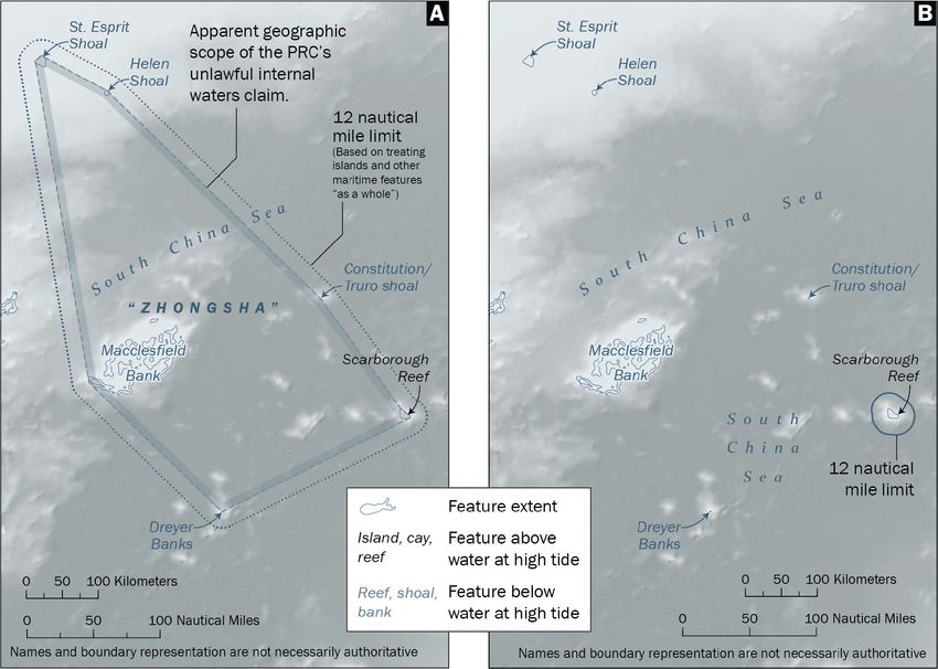
Contents

EXECUTIVE SUMMARY .......................................................................................................... 1
INTRODUCTION......................................................................................................................... 2
GEOGRAPHIC OVERVIEW OF THE SOUTH CHINA SEA ............................................... 2
BASIS FOR ANALYSIS .............................................................................................................. 5
   SUMMARY OF PRC MARITIME CLAIMS IN THE SOUTH CHINA SEA .............................................. 5
   SOVEREIGNTY CLAIMS OVER MARITIME FEATURES .................................................................... 6
   BASELINES ................................................................................................................................... 7
   MARITIME ZONES ........................................................................................................................ 9
   HISTORIC RIGHTS......................................................................................................................... 9
ANALYSIS OF PRC MARITIME CLAIMS IN THE SOUTH CHINA SEA ...................... 11
   SOVEREIGNTY CLAIMS OVER MARITIME FEATURES .................................................................. 11
   BASELINES ................................................................................................................................. 14
     Xisha Qundao........................................................................................................................ 15
     Dongsha Qundao .................................................................................................................. 16
     Zhongsha Qundao ................................................................................................................. 17
     Nansha Qundao .................................................................................................................... 18
     Customary International Law ............................................................................................... 22
   MARITIME ZONES ...................................................................................................................... 24
     Internal Waters ..................................................................................................................... 24
     Territorial Sea....................................................................................................................... 25
     Contiguous Zone ................................................................................................................... 25
     Exclusive Economic Zone and Continental Shelf ................................................................. 26
   HISTORIC RIGHTS....................................................................................................................... 27
CONCLUSION ........................................................................................................................... 29

ANNEXES ................................................................................................................................... 31
   ANNEX 1 .................................................................................................................................... 31
   ANNEX 2 .................................................................................................................................... 33
   ANNEX 3 .................................................................................................................................... 36
   ANNEX 4 .................................................................................................................................... 39
   ANNEX 5 .................................................................................................................................... 43
   ANNEX 6 .................................................................................................................................... 44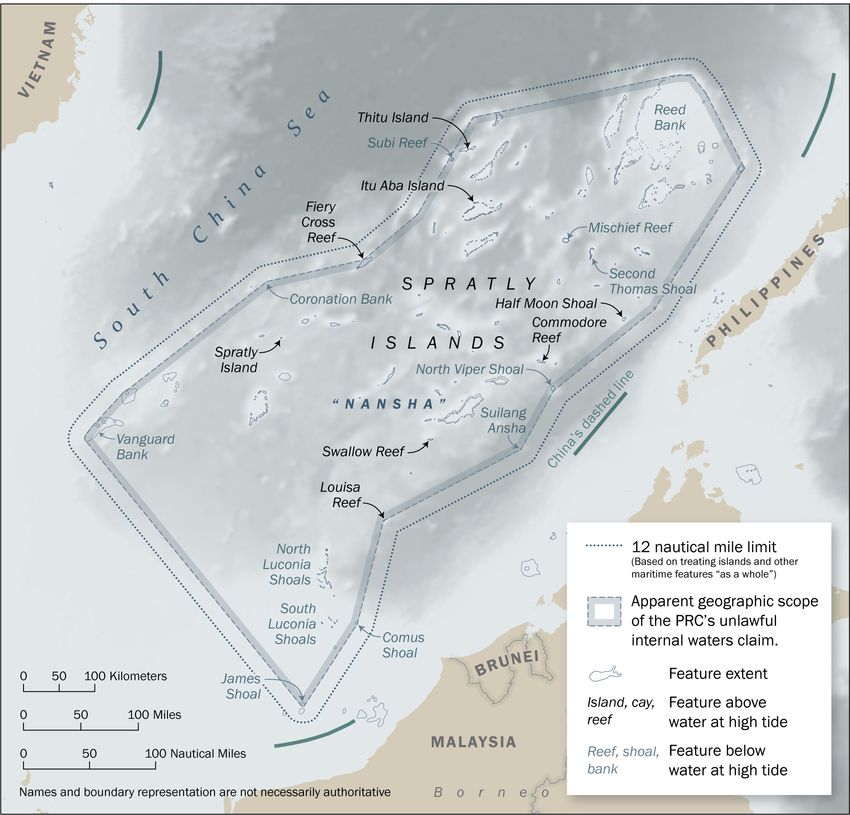
Executive Summary
This study examines the maritime claims of the People’s Republic of China (PRC) in the South
China Sea. The PRC’s expansive maritime claims in the South China Sea are inconsistent with
international law as reflected in the 1982 United Nations Convention on the Law of the Sea
(“Convention”).

The PRC asserts four categories of maritime claims* in the South China Sea:

    •    Sovereignty claims over maritime features. The PRC claims “sovereignty” over more
         than one hundred features in the South China Sea that are submerged below the sea surface
         at high tide and are beyond the lawful limits of any State’s territorial sea. Such claims are
         inconsistent with international law, under which such features are not subject to a lawful
         sovereignty claim or capable of generating maritime zones such as a territorial sea.

    •    Straight baselines. The PRC has either drawn, or asserts the right to draw, “straight
         baselines” that enclose the islands, waters, and submerged features within vast areas of
         ocean space in the South China Sea. None of the four “island groups” claimed by the PRC
         in the South China Sea (“Dongsha Qundao,” “Xisha Qundao,” “Zhongsha Qundao,” and
         “Nansha Qundao”) meet the geographic criteria for using straight baselines under the
         Convention. Additionally, there is no separate body of customary international law that
         supports the PRC position that it may enclose entire island groups within straight baselines.

    •    Maritime zones. The PRC asserts claims to internal waters, a territorial sea, an exclusive
         economic zone, and a continental shelf that are based on treating each claimed South China
         Sea island group “as a whole.” This is not permitted by international law. The seaward
         extent of maritime zones must be measured from lawfully established baselines, which are
         normally the low-water line along the coast. Within its claimed maritime zones, the PRC
         also makes numerous jurisdictional claims that are inconsistent with international law.

    •    Historic rights. The PRC asserts that it has “historic rights” in the South China Sea. This
         claim has no legal basis and is asserted by the PRC without specificity as to the nature or
         geographic extent of the “historic rights” claimed.

The overall effect of these maritime claims is that the PRC unlawfully claims sovereignty or some
form of exclusive jurisdiction over most of the South China Sea. These claims gravely undermine
the rule of law in the oceans and numerous universally-recognized provisions of international law
reflected in the Convention. For this reason, the United States and numerous other States have
rejected these claims in favor of the rules-based international maritime order within the South
China Sea and worldwide.

*
  Islands in the South China Sea over which the PRC claims sovereignty are also claimed by other States. This study
examines only the maritime claims asserted by the PRC and does not examine the merits of sovereignty claims to
islands in the South China Sea asserted by the PRC or other States. The United States takes no position as to which
country has sovereignty over the islands in the South China Sea, which is not a matter governed by the law of the sea.

                                                          1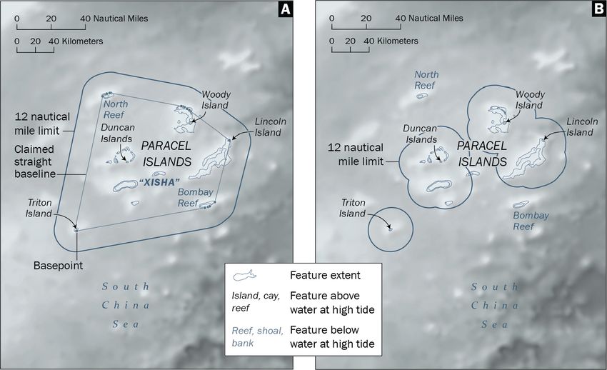
Introduction
This study builds on Limits in the Seas No. 143 (2014), which analyzed the People’s Republic of
China’s (PRC’s) ambiguous “dashed-line” claim in the South China Sea. 1 Limits in the Seas No.
143 concluded that the PRC’s dashed-line claim was neither a valid national boundary nor a valid
claim to historic rights in the South China Sea. The PRC’s maritime claims within the dashed line,
the study concluded, are consistent with international law only if they are limited to the maritime
zones generated from land features (i.e., the mainland and islands), in accordance with relevant
provisions of the 1982 United Nations Convention on the Law of the Sea (“Convention”). 2

In 2016, having considered the PRC’s dashed-line claim, an arbitral tribunal convened in
accordance with the Convention reached a similar conclusion in The South China Sea Arbitration
(The Republic of the Philippines v. The People’s Republic of China). The arbitral tribunal issued
a unanimous decision, which is final and binding on the Philippines and the PRC, 3 finding that:

        China’s claims to historic rights, or other sovereign rights or jurisdiction, with respect to
        the maritime areas of the South China Sea encompassed by the relevant part of the ‘nine-
        dash line’ are contrary to the Convention and without lawful effect to the extent that they
        exceed the geographic and substantive limits of China’s maritime entitlements under the
        Convention [and that] the Convention superseded any historic rights, or other sovereign
        rights or jurisdiction in excess of the limits imposed therein.4

Immediately following the issuance of the tribunal’s award, the PRC released a statement 5 (Annex
1 to this study) and a white paper 6 that advanced a new articulation of its maritime claims in the
South China Sea. The PRC has also communicated notes verbales to the United Nations and its
Member States that describe its South China Sea claims in similar terms (Annex 2 to this study).
These documents address a range of the PRC’s maritime claims in the South China Sea, including
claims related to historic rights, baselines, and maritime zones claimed from islands, island groups,
and other maritime features.

This Limits in the Seas study examines the PRC’s revised articulation of its South China Sea
maritime claims following the issuance of the decision in The South China Sea Arbitration. To
the extent the PRC’s claims are not specified in domestic laws or regulations, this study relies on
the PRC’s official statements, position papers, and diplomatic communications to assess their
character and consistency with international law.

1
  Limits in the Seas No. 143, “China: Maritime Claims in the South China Sea,” U.S. Dep’t of State (2014).
2
  United Nations Convention on the Law of the Sea, opened for signature Dec. 10, 1982, 1833 UNTS 397 (entered
into force Nov. 16, 1994).
3
  Id. art. 296.
4
  The South China Sea Arbitration (The Republic of the Philippines v. The People’s Republic of China), Permanent
Court of Arbitration (PCA) Case Nο. 2013-19, Award of July 12, 2016, para. 278, available from the PCA website.
5
  “Statement of the Government of the People’s Republic of China on China’s Territorial Sovereignty and Maritime
Interests in the South China Sea,” July 12, 2016, available from the website of PRC’s Ministry of Foreign Affairs
(also Annex 1 to this study).
6
  “China Adheres to the Position of Settling Through Negotiation the Relevant Disputes Between China and the
Philippines in the South China Sea,” July 13, 2016 (hereinafter White Paper), available from the website of PRC’s
Ministry of Foreign Affairs.

                                                        2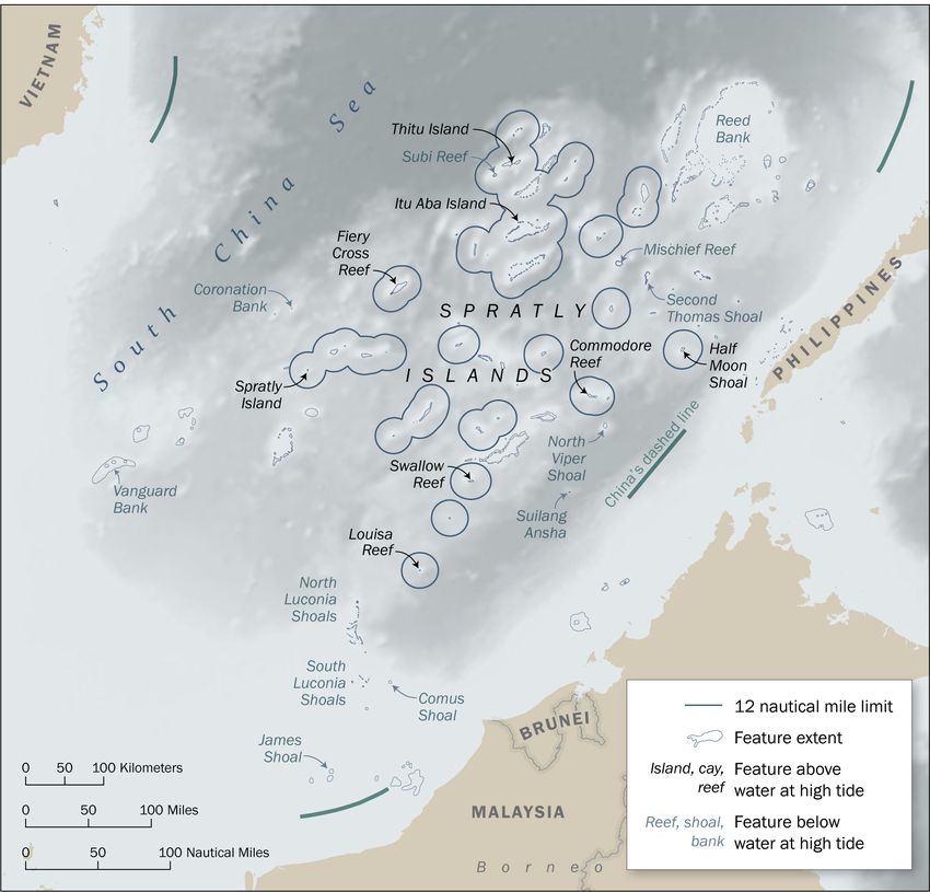
The next section provides a brief Geographic Overview of the South China Sea. The Basis for
Analysis section that follows summarizes the PRC’s maritime claims in the South China Sea and
discusses the provisions of the international law of the sea that are relevant to those claims. The
Analysis section then examines PRC maritime claims from a geographic and legal perspective,
including their consistency with the international law of the sea. The Conclusion briefly
summarizes the results of this study’s analysis of PRC maritime claims in the South China Sea.
Geographic Overview of the South China Sea
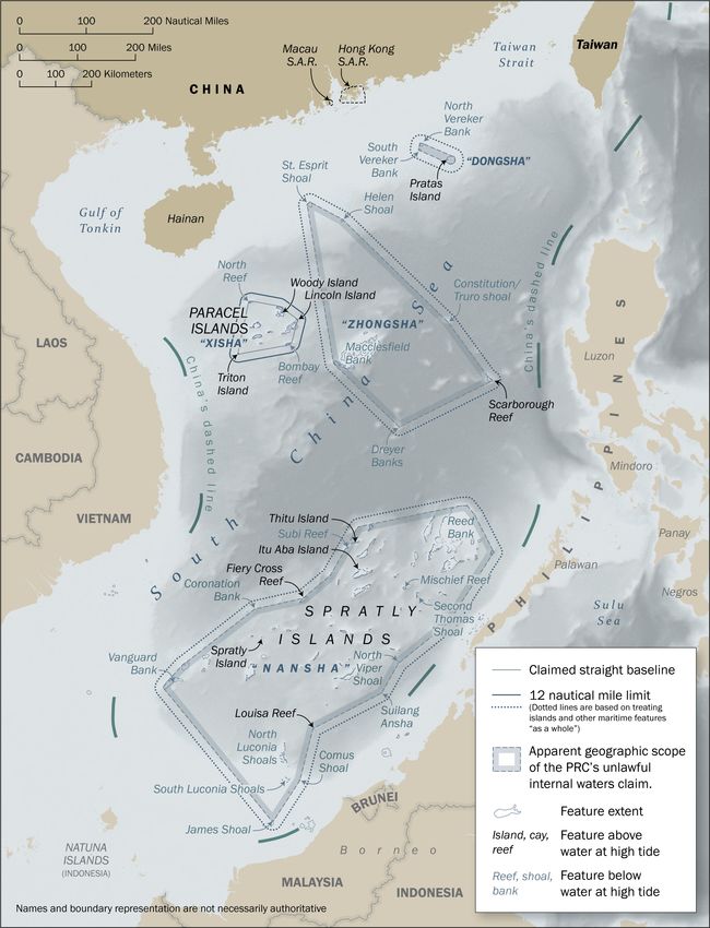
The South China Sea is a large, semi-enclosed sea surrounded by Brunei, China, Indonesia,
Malaysia, the Philippines, Singapore, Taiwan, and Vietnam (Map 1). There are many small islands
in the South China Sea, including groups of islands located at considerable distances from the
mainland coast of the nearest littoral State. In their natural state, these South China Sea islands
have a total land area of only about 15 square kilometers (km2). There are also numerous low-tide
elevations and entirely submerged features in the South China Sea, which are not “islands” as
defined by international law. 7
Map 1 shows geographic features relevant to this study, some of which are briefly described below:
• Pratas Island. Pratas Island is a single island that surmounts Pratas Reef and is located in
the northeast part of the South China Sea, 130 nautical miles (M) south of mainland China.
• Paracel Islands. The Paracel Islands are located in the northwest part of the South China
Sea, roughly equidistant from Hainan and Vietnam’s mainland.
• Macclesfield Bank. Macclesfield Bank is a large and fully submerged feature that lies
southeast of the Paracel Islands. The bank is approximately 70-M long and 40-M wide.
• Scarborough Reef. Scarborough Reef is a triangle-shaped reef surmounted by very small
islands. It is located between Macclesfield Bank and the Philippine island of Luzon.
• Spratly Islands. The Spratly Islands are spread across a large geographic area in the
southern part of the South China Sea. This island group is interspersed with numerous
reefs, banks, and other submerged features. The largest island, Itu Aba Island, has a land
area of less than 0.5 km2 in its natural state.
• James Shoal. James Shoal lies south of the Spratly Islands, approximately 60 M north of
Malaysia’s coast. This submerged feature lies about 20 meters below sea level.
The PRC claims sovereignty over all of the South China Sea islands (and numerous other maritime
features, as discussed below). Each island or group of islands is claimed by at least one other
claimant: Philippines (Scarborough Reef and some of the Spratly Islands), Malaysia (some of the
Spratly Islands), Brunei (Louisa Reef, within the Spratly Islands), Vietnam (Spratly Islands and
Paracel Islands), and Taiwan (all islands and island groups). The geographic features described
above are located within the dashed lines that have appeared in various locations on some PRC
maps since being published by the Nationalist government of the Republic of China in 1947
(Map 1).8 To the south, seemingly outside the dashed lines, are Indonesia’s Natuna
Islands, the territorial sovereignty of which is not disputed.
7
Convention, supra note 2, art. 121(1). See infra, pp. 6–7.
8
With respect to the dashed lines and related historical maps, see Limits in the Seas No. 143, supra note 1, at 3–7.
3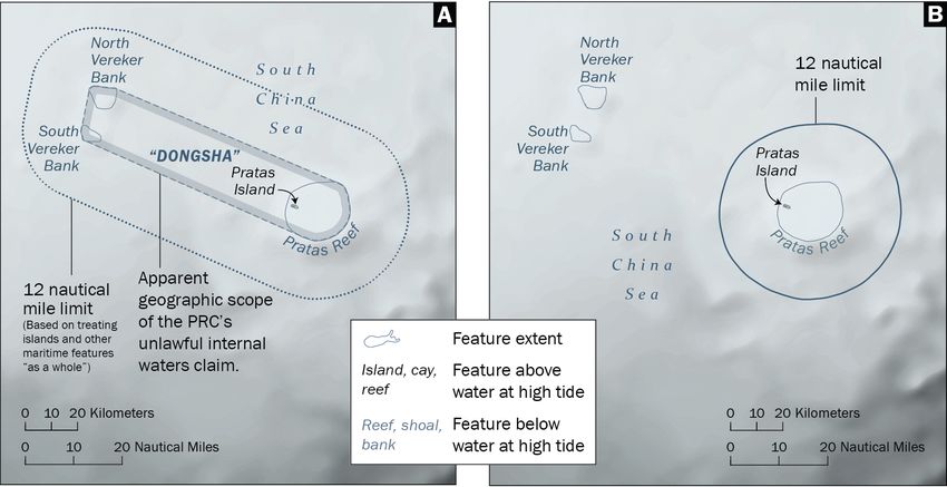
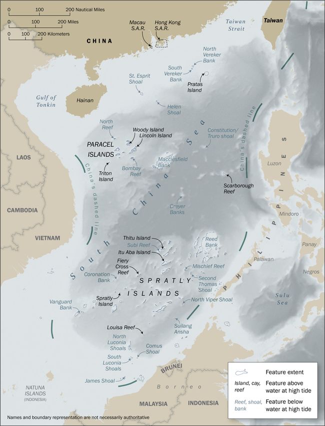
Map 1. Overview map of the South China Sea with key features labeled.

                                                      4
Basis for Analysis
The basis for this study’s analysis of PRC maritime claims is the international law of the sea, as
reflected in the Convention. 9 The PRC ratified the Convention on June 7, 1996. The Convention
is binding on the PRC and other parties to the Convention as a matter of international treaty law. 10
The United States considers the substantive provisions of the Convention cited in this section to
reflect customary international law binding on all States, as do international courts and tribunals. 11

This section briefly describes the PRC’s maritime claims in the South China Sea and the provisions
of the international law of the sea relevant to these claims.

Summary of PRC Maritime Claims in the South China Sea

This study addresses four categories of the PRC’s maritime claims in the South China Sea: (1)
sovereignty claims over maritime features, (2) baselines, (3) maritime zones, and (4) historic rights.

(1) Sovereignty claims over maritime features. The PRC claims sovereignty over four “island
groups” in the South China Sea. This includes claims to sovereignty over the actual islands, and
also claims to sovereignty over maritime features that do not meet the definition of “island” under
the Convention, 12 such as low-tide elevations and seabed features that are fully submerged. Only
the latter category, namely claims to maritime features, are examined in this study. 13

(2) Baselines. With respect to baselines, the PRC has drawn straight baselines (purporting to
enclose all the waters within as internal waters) around one of the island groups in the South China
Sea, the Paracel Islands. 14 The PRC’s statements indicate, however, that straight baselines “shall
apply” to all of its claimed islands and island groups. 15

(3) Maritime zones. Through its domestic legislation and statements, the PRC claims a territorial
sea, a contiguous zone, an exclusive economic zone (EEZ), and a continental shelf in the South
China Sea. 16 The PRC asserts that these maritime zones are “based on Nanhai Zhudao,” which

9
  Convention, supra note 2.
10
   Vienna Convention on the Law of Treaties, art. 26, opened for signature May 23, 1969, 1155 UNTS 331 (entered
into force Jan. 27, 1980) (stating that, under the principle of pacta sunt servanda, “[e]very treaty in force is binding
upon the parties to it and must be performed by them in good faith.”).
11
   See, e.g., J.A. Roach, “Today’s Customary International Law of the Sea,” 45 Ocean Dev’t & Int’l L. 239 (2014).
12
   Convention, supra note 2, art. 121(1).
13
   This study makes no attempt to examine the merits of sovereignty claims by the PRC or other States to land
features in the South China Sea. The United States has repeatedly reaffirmed that it takes no position as to which
country has sovereignty over the islands of the South China Sea, which is not a matter governed by the law of the
sea. See Limits in the Seas No. 143, supra note 1, at 11, note 25.
14
   Declaration of the Government of the People’s Republic of China on the baselines of the territorial sea
(hereinafter 1996 Declaration) (Annex 5 to this study), May 15, 1996, available from UN Division for Ocean
Affairs and the Law of the Sea (DOALOS), at its website pertaining to the PRC’s maritime claims.
15
   See infra, notes 55 and 56, and corresponding text.
16
   Law on the Territorial Sea and Contiguous Zone of 25 February 1992 (hereinafter 1992 Law) (Annex 3 to this
study) and Exclusive Economic Zone and Continental Shelf Act, June 26, 1998 (hereinafter 1998 Law) (Annex 4 to
this study), available from DOALOS, supra note 14.

                                                           5
consists of the four “island groups” (and associated features) as collective units over which the
PRC claims sovereignty.
(4) Historic rights. Following the arbitral tribunal’s decision referred to above, the PRC
unequivocally asserted a claim to “historic rights in the South China Sea.” 17 The PRC has since
repeated this claim in numerous communications to the United Nations and its Member States. 18
Sovereignty Claims over Maritime Features
A fundamental principle of the international law of the sea is that the “land dominates the sea”;
land is the “legal source of the power” of a coastal State to exercise authority over its adjacent
maritime space. 19 Accordingly, it is necessary in the first instance to distinguish between features
that are (1) land territory in a legal sense and those that are (2) submerged (i.e., below sea level)
in their natural state. The former generates maritime zones, whereas the legal status of the latter
depends on the maritime zone in which it is located.
Land territory includes continental landmasses and islands. These can be subject to a lawful
sovereignty claim (i.e., capable of appropriation) and are capable of generating maritime zones,
namely a territorial sea, contiguous zone, EEZ, and continental shelf (Table 1). 20 Article 121 of
the Convention defines an “island” as “a naturally formed area of land, surrounded by water, which
is above water at high tide.” Islands are generally entitled to the same maritime zones as other
(continental) land territory (Article 121(2)). Paragraph 3 of Article 121, however, provides an
exception for islands that are “[r]ocks which cannot sustain human habitation or economic life of
their own”; this category of islands “shall have no exclusive economic zone or continental shelf.”
Submerged features and low-tide elevations are part of the maritime domain and their status is
governed by the law of the sea. The sovereignty of the coastal State extends from its land territory
to its adjacent territorial sea. Submerged features and low-tide elevations that lie beyond the
territorial sea limit, however, cannot be subject to the sovereignty of the coastal State. Moreover,
such features, regardless of their location, do not generate any maritime zones of their own (Table
1).
The descriptive element of a feature’s geographic name—atoll, bank, island, reef, rock, shoal,
etc.—is not determinative of its legal status as an island or a submerged maritime feature. Rather,
the status of a feature is based on its physical characteristics in relation to the criteria set forth in
the Convention, summarized in Table 1. A feature’s status must also be assessed based on its
natural state.21 Land reclamation or other human activities that alter the natural state of a low-tide
17
PRC Government Statement, supra note 5, para. III(iv) (Annex 1 to this study). This statement did not describe
the underlying nature of the historic rights claimed or their geographic extent.
18
See, e.g., communications reproduced in Annex 2 to this study.
19
North Sea Continental Shelf (Germany v. Denmark), 1969 ICJ Rep. 3, para. 96, at 52 (Feb. 20).
20
See, e.g., Maritime Delimitation and Territorial Questions between Qatar and Bahrain (merits), 2001 ICJ Rep.
40, paras. 204–207, at 65–66 (Mar. 16); The South China Sea Arbitration, supra note 4, para. 309.
21
Convention, supra note 2, arts. 13 (low-tide elevations) and 121 (islands) (referring to “naturally formed” areas of
land, as distinct from “artificial islands” in article 60).
6Table 1. Geographic features and maritime entitlements.
Feature Part of
Convention Definition or Meaning land Maritime Zone Entitlements
article domain?
- a naturally formed area of land
Island All maritime zones, as provided for in the
- surrounded by water, and Yes
Art. 121(1) Convention
- above water at high tide
“rock” is a term that refers to an
“Rock” island that “cannot sustain human
Yes Only territorial sea and contiguous zone
Art. 121(3) habitation or economic life of
[its] own”
None, but the low-water line of the LTE may
Low-tide - a naturally formed area of land be used as the baseline for measuring the
elevation - surrounded by water breadth of maritime zones if the LTE is
No
(LTE) - above water at low tide, and “situated wholly or partly at a distance not
Art. 13 - submerged at high tide exceeding the breadth of the territorial sea from
the mainland or an island”
Submerged
- submerged at low and high tides No Not entitled to any maritime zones
feature
Artificial
islands,
installations, - artificially formed No Not entitled to any maritime zones 22
structures
Art. 60(8)
elevation or fully submerged feature cannot transform the feature into an island. 23 Similarly, an
island that is a “rock” under Article 121(3) cannot, through enhancement by human activity, be
transformed into an island that is fully entitled to maritime zones. 24 The Convention provides that
“[a]rtificial islands, installations and structures do not possess the status of islands” (Article 60(8)).
Baselines
International law, as reflected in Part II of the Convention, sets forth rules governing the baselines
from which the limits of maritime zones are measured. 25 Article 5 defines the normal baseline as
“the low-water line along the coast as marked on large-scale charts officially recognized by the
coastal State.” Additional related provisions are found in Articles 6 (reefs), 9 (mouths of rivers),
10 (bays), 11 (ports), 12 (roadsteads), and 13 (low-tide elevations).
22
“Safety zones” may be established around artificial islands, installations, and structures, pursuant to articles 60,
80, 147(2), and 260 of the Convention.
23
This is reflected in the Convention’s definition of an island as a “naturally formed area of land.” Id. See also The
South China Sea Arbitration, supra note 4, para. 305 (“As a matter of law, human modification cannot change the
seabed into a low-tide elevation or a low-tide elevation into an island. A low-tide elevation will remain a low-tide
elevation under the Convention, regardless of the scale of the island or installation built atop it.”).
24
The South China Sea Arbitration, supra note 4, para. 511 (noting that the Convention requires the status of a
feature under Article 121(3) to be ascertained “on the basis of its earlier, natural condition, prior to the onset of
significant human modification”).
25
Convention, supra note 2, arts. 3 (territorial sea), 33 (contiguous zone), 57 (EEZ), and 76(1) (continental shelf).
7The Convention also permits the method of straight baselines, but only where the coastal
geography meets certain conditions, in particular (1) “[i]n localities where the coastline is deeply
indented and cut into” or (2) where “there is a fringe of islands along the coast in its immediate
vicinity” (Article 7, paragraph 1). 26 The International Court of Justice (ICJ) has observed that:
. . . the method of straight baselines, which is an exception to the normal rules for the
determination of baselines, may only be applied if a number of conditions are met. This
method must be applied restrictively. Such conditions are primarily that either the coastline
is deeply indented and cut into, or that there is a fringe of islands along the coast in its
immediate vicinity. 27
Where the coastal geography allows for the use of straight baselines, Article 7 provides additional
requirements for the drawing of straight baselines. Relevant provisions state that “[t]he drawing
of straight baselines must not depart to any appreciable extent from the general direction of the
coast”; “the sea areas lying within the lines must be sufficiently closely linked to the land domain
to be subject to the regime of internal waters”; “[s]traight baselines shall not be drawn,” with
specific and limited exceptions, “to and from low-tide elevations”; and “[t]he system of straight
baselines may not be applied . . . in such a manner as to cut off the territorial sea of another State
from the high seas or an exclusive economic zone” (Article 7, paragraphs 3 to 6).
Part IV of the Convention contains the rules relating to archipelagic baselines that join the
outermost points of the outermost islands and drying reefs of an archipelago. Article 47 provides
detailed rules for the drawing of such baselines, including with respect to the lengths of the
segments and that the ratio of the area of the water to the area of the land enclosed by the baselines
must be between 1 to 1 and 9 to 1. Such baselines, however, may only be drawn by an
“archipelagic State,” which is “a State constituted wholly by one or more archipelagos and may
include other islands” (Articles 47(1), 46(a)). Decisions of courts and tribunals, 28 and the baseline
practices of other non-archipelagic States, 29 confirm that continental States that also include
archipelagos may not draw archipelagic baselines.
The articles of the Convention referred to above comprehensively regulate the baselines that
coastal States may establish. Where specific conditions described in those articles are not met, the
Convention requires the use of the normal baseline. As stated in Article 5, “[e]xcept where
otherwise provided in this Convention, the normal baseline” is the low-water line along the coast.
Waters on the landward side of the baseline are internal waters (Article 8), including the waters
within closing lines related to reefs, mouths of rivers, bays, and ports (Articles 6, 9, 10, and 11). 30
26
The straight baseline provisions in Article 7 are substantially the same as those found in Article 4 of the 1958
Convention on the Territorial Sea and the Contiguous Zone, opened for signature Apr. 29, 1958, 516 UNTS 205
(entered into force Sept. 10, 1964). Most of those provisions, in turn, were drawn from the ICJ’s 1951 judgment in
the Fisheries Case (United Kingdom v. Norway), 1951 I.C.J. 116 (Dec. 18).
27
Maritime Delimitation and Territorial Questions between Qatar and Bahrain, supra note 20, para. 212.
28
See, e.g., id. paras. 213–14 (evaluating the suitability of straight baselines in reference to Article 7 of the
Convention, notwithstanding Bahrain’s assertion that it is a “de facto archipelagic State”); The South China Sea
Arbitration, supra note 4, para. 573 (“The use of archipelagic baselines (a baseline surrounding an archipelago as a
whole) is strictly controlled by the Convention, where Article 47(1) limits their use to ‘archipelagic states.’”).
29
See State Practice Supplement to this study.
30
The waters landward of archipelagic baselines are “archipelagic waters.” Convention, supra note 2, art. 49.
8Maritime Zones
International law, as reflected in the Convention, contains rules governing a coastal State’s
entitlement to maritime zones.
Part II of the Convention sets forth the rules governing the territorial sea, which may extend up to
12 M from the baselines and in which the coastal State exercises sovereignty subject to the right
of innocent passage and other rules of international law (Articles 2, 3, and 17). Provisions related
to innocent passage are set forth in Articles 17 to 32. In addition, Part II describes a contiguous
zone, which may not extend beyond 24 M from the baselines, within which a coastal State may
exercise the control necessary to prevent and punish infringement of its customs, fiscal,
immigration or sanitary laws and regulations within its territory or territorial sea (Article 33).
Part V of the Convention sets forth provisions related to the EEZ, which may extend up to 200 M
from the baselines (Article 57). Within the EEZ, the coastal State has enumerated rights, notably,
“sovereign rights for the purpose of exploring and exploiting, conserving and managing the natural
resources” and “jurisdiction as provided for” in the Convention with regard to “the establishment
and use of artificial islands, installations and structures,” as well as “marine scientific research”
and “the protection and preservation of the marine environment” (Article 56). At the same time,
subject to the relevant provisions of the Convention, all States enjoy the freedoms of navigation,
overflight, laying and maintenance of submarine cables, and other internationally lawful uses of
the sea related to these freedoms (Articles 58 and 87).
Part VI of the Convention sets forth provisions relating to the continental shelf, which extends to
the outer edge of the continental margin or to a distance of 200 M from the baselines, as described
in Article 76. The coastal State exercises sovereign rights for the purpose of exploring the
continental shelf and exploiting its natural resources; these rights are “exclusive” and “do not
depend on occupation, effective or notional, or on any express proclamation” (Article 77).
However, subject to certain provisions, all States are entitled to lay submarine cables and pipelines
on the continental shelf (Article 79).
Historic Rights
No provision of the Convention contains the term “historic rights,” nor is there a uniform
understanding of what, specifically, the term means as a matter of international law. 31 The
substantive provisions of the Convention refer to “historic bays” or “historic title” in two instances.
First, Article 10 (bays) provides that the provisions of that article concerning juridical bays “do
not apply to so-called ‘historic’ bays.” Second, Article 15 (delimitation of the territorial sea
between States with opposite or adjacent coasts) provides that the general rule governing
delimitation of overlapping territorial sea entitlements “does not apply” in certain situations
involving “historic title or other special circumstances.” 32
31
The tribunal in The South China Sea Arbitration stated that “[t]he term ‘historic rights’ is general in nature
[. . . and] may include sovereignty, but may equally include more limited rights, such as fishing rights or rights of
access, that fall well short of a claim of sovereignty.” Supra note 4, para. 225.
32
Article 298 pertaining to exceptions to dispute settlement procedures also refers to “historic bays or titles.”
9These provisions, which are substantially identical to those contained in Articles 7 and 12 of the
1958 Convention on the Territorial Sea and the Contiguous Zone, 33 are limited geographically and
substantively. They apply only with respect to bays and similar near-shore coastal configurations.
They are also drafted as safeguards, such that the provisions of Article 10 and Article 15 “do not
apply” with respect to the aforementioned situations of historic bays and title, respectively.
There is no provision in the Convention that safeguards “historic rights.” 34 Accordingly, any claim
to such rights would need to conform to the Convention’s provisions, including with respect to the
areas of EEZ, continental shelf, and high seas. As the Gulf of Maine Chamber of the ICJ noted in
its 1984 judgment, the advent of exclusive jurisdiction of a coastal State over fisheries within 200
M of its coast overrides the prior usage and rights of other States in that area. 35 The tribunal in
The South China Sea Arbitration reached the same conclusion. 36 The Convention’s maritime
zones and their geographic limits set forth the framework governing all parts of the sea, a
framework from which no reservations are permitted (Article 309). In particular, Articles 56 and
77 of the Convention leave no room for claims by any State that derogate from the exclusive
sovereign rights of the coastal state with respect to the EEZ and continental shelf, except as
provided in the Convention or by agreement with the coastal State. 37
33
Convention on the Territorial Sea and the Contiguous Zone, supra note 26.
34
In this regard, the 1962 study on historic waters commissioned by the Conference that adopted the 1958 Geneva
Conventions on the law of the sea states that, if there is no clause included in an article that safeguards historic title,
“the provisions of the article must prevail . . . . This seems to follow a contrario from the fact that articles 7 and 12
[of the 1958 Convention] have express clauses reserving historic rights; articles without such a clause must be
considered not to admit an exception in favour of such rights” (emphases added). Int’l Law Comm’n, Juridical
Régime of Historic Waters, Including Historic Bays, 2 Y.B. Int’l L. Comm’n 1 (1962), U.N. Doc. A/CN.4/143, para.
75.
35
Delimitation of the Maritime Boundary in the Gulf of Maine Area (Canada/U.S.A), 1984 I.C.J. 246, paras. 233,
235, at 340–341 (Oct. 12). With respect to the “invocation of historic rights, though that expression has not been
used [by the United States]” the Chamber stated that “to the extent that [areas of U.S. historical fishing
predominance] had become part of the exclusive fishery zone of the neighbouring State, no reliance could any
longer be placed on that predominance. Clearly, whatever preferential situation the United States may previously
have enjoyed, this cannot constitute in itself a valid ground for its now claiming the incorporation into its own
exclusive fishery zone of any area which, in law, has become part of Canada’s” (emphasis added).
36
The South China Sea Arbitration, supra note 4, para. 278.
37
In the parts of the Convention directly relating to maritime zones, the Convention contains some provisions
relating to historic or traditional uses of the sea. Article 62(3) requires coastal States to take into account “the need
to minimize economic dislocation in States whose nationals have habitually fished” (emphasis added) in the EEZ.
Article 51 also requires archipelagic States, within their archipelagic waters, to recognize “traditional fishing rights
and other legitimate activities” (emphasis added) of immediately adjacent neighboring States. Such provisions
might provide a basis for one coastal State to seek access to the fisheries of another coastal State based on prior
usage. They do not, however, provide a basis for sovereignty, sovereign rights, or jurisdiction.
10Analysis of PRC Maritime Claims in the South China Sea 38
This section analyzes four categories of the PRC’s maritime claims in the South China Sea: (1)
sovereignty claims over maritime features, (2) baselines, (3) maritime zones, and (4) historic
rights. The analysis of the PRC’s maritime claims is based on the legal rules summarized in the
preceding section, Basis for Analysis. The analysis does not address the claims of the PRC or any
other country to sovereignty over the islands in the South China Sea (i.e., territorial sovereignty
disputes), which is a matter on which the United States takes no position. 39
Sovereignty Claims over Maritime Features
The PRC asserts sovereignty over what it calls “Nanhai Zhudao,” or the South China Sea islands
and other features that consist of “Dongsha Qundao,” “Xisha Qundao,” “Zhongsha Qundao,” and
“Nansha Qundao.” 40 The China Geographical Names Committee has issued a list of geographic
features associated with each of these four claimed “archipelagos” or “island groups” (qundao, 群
島). 41 This information is summarized in Table 2, and the geographic extents of the PRC’s claimed
“island groups” are shown in Maps 2 to 6.
Table 2. Chinese-named “island groups” and their corresponding geographic features.
Chinese Name Corresponding geographic features
Pratas Island, Pratas Reef, North Vereker Bank, and South Vereker
Dongsha Qundao (东沙群島)
Bank.
Paracel Islands, which are composed of approximately two dozen
Xisha Qundao (西沙群島)
small islands, and other submerged features in the vicinity.
Scarborough Reef, Macclesfield Bank, and other submerged
Zhongsha Qundao (中沙群島) features such as Saint Esprit Shoal and Helen Shoal (north),
Constitution shoal (central), and Dreyer Banks (south).
Spratly Islands, which include approximately 40 small islands with
a total land area of approximately 2 km2, as well as approximately
150 low-tide elevations and fully submerged features within and
Nansha Qundao (南沙群島) surrounding these islands, such as James Shoal and Vanguard
Bank. Nansha Qundao is the largest of the PRC’s claimed “island
groups,” covering approximately 351,000 km2 of maritime space.
38
Geographic analysis was completed using tools in Esri ArcGIS 10.7.1 and CARIS LOTS 4.1.1.
39
See supra, note 13, describing U.S. policy on disputed islands.
40
PRC Government Statement, supra note 5, para. III (Annex 1 to this study); see also PRC communication
CML/14/2019 of December 12, 2019 (Annex 2.A to this study); 1992 Law, supra note 16, art. 2 (Annex 3 to this
study). The United States takes no position on these sovereignty claims to the extent they pertain to features that are
lawfully subject to sovereignty claims by any State. See supra, note 13.
41
“Standard Place Names of the South China Sea Islands,” China Geographical Names Committee (1983),
reproduced online at, inter alia, unanhai.com, nansha.org.cn, and spratlys.org. In its 2020 announcement of
additional names of South China Sea features, the PRC’s Ministry of Civil Affairs confirmed that this 1983
publication “continues to be valid” (继续有效). For additional information, see “Summary of Records of Nanhai
Zhudao,” Beijing Daily, July 25, 2016, available online; “South China Sea Islands,” Institute of Geographic
Sciences and Natural Resources Research, Chinese Academy of Sciences, Mar. 26, 2007, available online;
“Dongsha Islands,” China Borderlands Research Institute, Chinese Academy of Social Sciences, Sept. 14, 2014,
available online.
11Map 2. Illustrative map of the apparent geographic extents of Dongsha Qundao, Xisha Qundao, Zhongsha Qundao,
and Nansha Qundao, from which the PRC claims its maritime zones.
12Although the PRC has long claimed sovereignty over Dongsha Qundao, Xisha Qundao, Zhongsha
Qundao, and Nansha Qundao, 42 its recent statements make clear that the PRC’s sovereignty claims
extend to features that are not “islands” as defined in Article 121(1) of the Convention and not
located within a lawful territorial sea. According to the PRC, for the purposes of claiming
sovereignty and maritime zones, the island groups are each to be regarded “as a whole.” 43 Thus,
according to the PRC, “[t]hese Islands include, among others, islands, reefs, shoals and cays of
various numbers and sizes.” 44 As characterized by the Chinese Society for International Law,
“China’s position” is that an archipelago is to be treated “as a unit” for purposes of sovereignty
and maritime entitlements. 45 Further, the Chinese Society states that “[s]overeignty over an
archipelago as a unit naturally covers sovereignty over each and every component part,” namely
“all component features and the interconnecting waters.” 46
For instance, as part of the PRC’s claim to sovereignty over the Nansha Qundao “as a whole,” it
claims sovereignty over nearly 200 features, most of which are submerged. 47 This includes
entirely submerged features, such as Reed Bank, Vanguard Bank, and James Shoal, 48 as well as
features like Mischief Reef 49 and Second Thomas Shoal that are low-tide elevations in their natural
state and located beyond the lawful limits of any State’s territorial sea (Map 2).
As discussed above in the Basis for Analysis section, the acquisition of “sovereignty” over features
that are part of the seabed derives from the law of the sea and not from the rules for the acquisition
of sovereignty over land territory. The status of submerged features in the South China Sea, such
as those claimed by the PRC within its “island groups,” depends upon the maritime zone in which
they are situated (e.g., territorial sea, continental shelf). Thus, while taking no position on the
PRC’s sovereignty claims to particular islands in the South China Sea, 50 the United States has
rejected assertions of sovereignty based on features that do not meet the definition of an island or
42
Declaration on China’s Territorial Sea, reprinted in Limits in the Seas No. 43: “Straight Baselines: People’s
Republic of China,” U.S. Dep’t of State (1972), para. 4.
43
See, e.g., Position Paper of the Government of the PRC on the Matter of Jurisdiction in the South China Sea
Arbitration Initiated by the Republic of the Philippines, Dec. 7, 2014, available from the website of the PRC’s
Ministry of Foreign Affairs (MFA) (referring to “China’s sovereignty over the Nansha Islands as a whole”). See
also Foreign Ministry Spokesperson Hua Chunying’s Remarks on Relevant Issue about Taiping Dao, June 3, 2016,
available from the MFA website and Foreign Ministry Spokesperson Hua Chunying’s Regular Press Conference,
Mar. 24, 2016, available from the MFA website (both referring to “the Nansha Islands as a whole”).
44
White Paper, supra note 6, para. 2.
45
Chinese Society of International Law, “The South China Sea Arbitration Awards: A Critical Study,” 17 Chinese J.
Int’l L. 207, 475 (2018).
46
Id. at 476.
47
For the geographic scope of Nansha Qundao, see supra, note 41 and corresponding text.
48
Despite it being a submerged feature, numerous Chinese sources refer to James Shoal as the southernmost point of
China’s territory. See Limits in the Seas No. 143, supra note 1, at 16, note 49 and corresponding text.
49
Permanent Mission of the People’s Republic of China to the United Nations, communication CML/1/2021, Jan.
28, 2021 (excerpt reproduced in Annex 2.G of this study); The South China Sea Arbitration, supra note 4, paras.
374–78 (concluding that Mischief Reef is a low-tide elevation).
50
See supra, note 13, describing U.S. policy on disputed islands.
13are not within the lawful limits of the territorial sea. 51 Other countries have similarly rejected the
PRC’s claims related to submerged features and low-tide elevations. 52
It is notable that the PRC claims sovereignty over the submerged features within its claimed “island
groups,” even without establishing baselines. 53 The PRC’s assertions in this regard have no
support in either the Convention or the practice of States. Even for an archipelagic State,
sovereignty over the waters and submerged features within an archipelago is not automatic; it
exists only when “enclosed by the archipelagic baselines drawn in accordance with article 47,” 54
or where islands are so closely spaced such that the waters between them lie entirely within the
territorial sea limits. As a non-archipelagic State, the means for the PRC to assert sovereignty over
the waters and submerged features within its claimed “island groups” would be to establish lawful
baselines and maritime zones measured from the baselines. As discussed below, the PRC has not
done this.
Baselines
The PRC’s 1992 Law provides that the PRC uses “the method of straight baselines,” and this
legislation does not refer to the normal baseline or other baseline methods set forth in the
Convention. 55 As discussed in the Basis for Analysis section, straight baselines may only be used
in particular geographic circumstances. Following the issuance of the arbitral tribunal’s decision
in 2016, the PRC stated expressly that “the straight baselines method . . . shall apply to all territories
of the People’s Republic of China, including ‘Dongsha Qundao, Xisha Qundao, Zhongsha
Qundao, Nansha Qundao and all the other islands belonging to China.’” 56
Accordingly, this section analyzes the suitability of straight baselines for Dongsha Qundao, Xisha
Qundao, Zhongsha Qundao, and Nansha Qundao. To date, the Xisha Qundao (Paracel Islands) is
the only “island group” in the South China Sea around which the PRC has formally claimed
straight baselines. 57 These baselines are shown on Maps 2 and 3A. Maps 2, 4A, 5A, and 6A depict
lines surrounding Dongsha Qundao, Zhongsha Qundao, and Nansha Qundao. These depictions,
however, are not authoritative and are not baselines formally asserted by the PRC. Rather, they
51
Letter from the Permanent Representative of the United States of America to the United Nations, UN Doc. No.
A/74/874–S/2020/483, June 1, 2020 (“China may not assert sovereignty over, or claim maritime zones derived from,
entirely submerged features . . . . Such features do not form part of the land territory of a State in a legal sense,
meaning that they are not subject to appropriation and cannot generate a territorial sea or other maritime zones under
international law.”).
52
See, e.g., Australian Mission to the United Nations, diplomatic note No. 20/026, July 23, 2020 (rejecting “China’s
claims to maritime zones generated by submerged features, or low tide elevations in a manner inconsistent with
UNCLOS . . . .”); Permanent Mission of the Socialist Republic of Viet Nam to the United Nations, Note No. 22/HC-
2020, Mar. 30, 2020 (protesting China’s claims and stating “low-tide elevations or submerged features are not
capable of appropriation and do not, in and of themselves, generate entitlements to any maritime zones”); see also
New Zealand Permanent Mission to the United Nations, Note No. 08/21/02 (Aug. 3, 2021).
53
This argument is advanced further in Chinese Society, supra note 45, at 477 (stating that the tribunal failed to
recognize “the fact that the interconnecting waters within the [Spratly] archipelago are under China’s sovereignty”).
54
Convention, supra note 2, art. 49 (emphasis added).
55
1992 Law, supra note 16, art. 3 (Annex 3 to this study).
56
White Paper, supra note 6, para. 34.
57
1996 Declaration, supra note 14 (Annex 5 to this study).
14illustrate the “apparent geographic scope of the PRC’s unlawful internal waters claims,” as
described in the map legends. Consistent with the PRC’s approach with Xisha Qundao, the lines
depicted for Dongsha Qundao, Zhongsha Qundao, and Nansha Qundao are based on (1) the
geographic extents of the these “island groups” (as defined by the PRC 58), (2) the PRC’s assertion
that it “shall” use straight baselines, and (3) the PRC’s assertion that its claimed island groups are
each to be treated “as a whole.” 59
Xisha Qundao
Xisha Qundao corresponds to the Paracel Islands (Maps 2 and 3), which are spread out over
approximately 80 M by 80 M of maritime space. The largest of the Paracel Islands, Woody Island,
has a land area in its natural state of approximately 1.6 km2. The remaining features in this area
are smaller islands and submerged reefs and banks.
Map 3. Xisha Qundao (Paracel Islands), (A) showing the PRC’s claimed straight baselines and territorial sea limits
and (B) showing the approximate 12-M territorial sea limits from lawful baselines. For location, see Map 2.
In 1996, the PRC promulgated a baseline system for the Xisha Qundao consisting of 28 basepoints
and segments. 60 The basepoints are located in five clusters along the outermost reef edges and are
connected by straight lines to form a kite-shaped baseline system that encloses the Paracel Islands
and other submerged features in the vicinity (Map 3A). Along the outer reef edges, baseline
58
See supra, note 41 and corresponding text (regarding the geographic extents of the PRC’s claimed island groups).
59
Notwithstanding the PRC’s approach of treating Dongsha Qundao, Zhongsha Qundao, and Nansha Qundao each
“as a whole,” the PRC may ultimately decide to not declare baselines enclosing the entire areas depicted as internal
waters in Maps 2, 4A, 5A, and 6A.
60
1996 Declaration, supra note 14 (Annex 5 to this study).
15segments are short (0.2 to 3.9 M). Longer segments connect the outermost reefs to one another,
including segments of 78.8 M (segment 14-15) and 75.8 M (segment 7-8). These baselines (and
claimed territorial sea limits) are depicted in Map 3A; Annex 6 to this study lists the lengths of
each segment.
The coastlines of the Paracel Islands are generally smooth with fringing reefs and therefore do not
meet the geographic requirements in Article 7 of the Convention for the use of straight baselines.
As stated in Limits in the Seas No. 117, “[w]hile it is possible for an island to meet the requirements
of article 7 and to have straight baselines drawn, these standards are not met here. The proper
baseline would be the low-water line of the islands and reefs.” 61 Numerous States, including
Australia, Japan, New Zealand, the Philippines, Vietnam, the United Kingdom, and the United
States have protested the PRC’s baselines around the Paracel Islands as inconsistent with
international law as reflected in the Convention. 62 Map 3B shows the approximate 12-M territorial
sea limits pertaining to the Paracel Islands that would result from lawful baselines, as permitted by
the Convention.
Dongsha Qundao
Dongsha Qundao is the “northernmost and smallest archipelago of the South China Sea Islands”
and includes Pratas Island, Pratas Reef, North Vereker Bank, and South Vereker Bank (Maps 2
and 4). 63 Pratas Island has a land area of approximately 2 km2 and lies on the western edge of a
large, circular atoll (Pratas Reef) having a diameter of approximately 24 km. In its statements, the
PRC translates Dongsha Qundao as Dongsha Islands (plural), although Pratas Island is the only
island in the vicinity. The submerged features of North Vereker Bank and South Vereker Bank
are located approximately 45 M northwest of Pratas Island.
Dongsha Qundao is not suitable for the application of straight baselines. The baseline of Pratas
Island and Pratas Reef should be determined in accordance with Article 5 (normal baseline) and
Article 6 (reefs). Waters inside the lagoon of Pratas Island may appropriately be characterized as
internal waters, and a closing line could be drawn across the atoll entrance to designate the
separation between internal waters and territorial sea. 64 Because they are submerged features,
North Vereker Bank and South Vereker Bank cannot form part of a “fringe of islands” for purposes
of applying Article 7 of the Convention, and these features do not generate any maritime zones of
their own. Map 4B shows the approximate 12-M territorial sea limits in this area that would result
from lawful baselines, as permitted by the Convention.
61
Limits in the Seas No. 117, “Straight Baselines Claim: China,” U.S. Dep’t of State (1996), at 8.
62
See communications of Australia, New Zealand, and Vietnam, supra note 52; Permanent Mission of Japan to the
United Nations, communication SC/21/002, Jan. 19, 2021; Law of the Sea: Report of the Secretary-General, UN
Doc., A/51/645 (1996), at 14–15 (describing protests of Vietnam and the Philippines); Law of the Sea Bulletin No.
32, at 91 (1996) (protests of Vietnam); U.S. Embassy Beijing, diplomatic note no. 335, Aug. 21, 1996 (U.S. protest),
excerpted in J.A. Roach and R. Smith, “Straight Baselines: The Need for a Universally Applied Norm,” 31 Ocean
Dev’t & Int’l L. 47, 62–63.
63
Chinese Academy of Sciences and China Geographical Names Committee, supra note 41.
64
DOALOS, Baselines: An Examination of the Relevant Provisions of the United Nations Convention on the Law of
the Sea, at 10–12 (1989) (noting that “it may . . . be inferred [from Article 6] that the enclosed waters [within a
lagoon] can be regarded as internal waters” and that “[i]f the lagoon waters of atolls are to be considered as internal
waters, it follows that it will be necessary to construct closing lines across the entrance channels.”).
16Map 4. Dongsha Qundao, (A) showing the apparent scope of the PRC’s unlawful internal waters claim and (B)
showing the approximate 12-M territorial sea limits from lawful baselines. For location, see Map 2.
Zhongsha Qundao
Zhongsha Qundao includes Scarborough Reef, Macclesfield Bank, and other submerged features
in the north and central parts of the South China Sea, including Saint Esprit Shoal and Helen Shoal
(north), Constitution shoal (central), and Dreyer Banks (south) (Maps 2 and 5). 65 Macclesfield
Bank is a large, shallow bank that is entirely submerged, with depths typically less than 100 meters;
its shallowest part is Walker Shoal, which is approximately 8 meters below sea level. To the east,
Scarborough Reef is mostly submerged, with just a few miniscule features protruding only a few
feet above the sea surface at high tide. The reef is approximately 18 km in length at its widest
location and has a total area of about 130 km2 (including the waters within the lagoon).
Zhongsha Qundao cannot be considered a unit from either a geographic or legal perspective,
including for purposes of drawing straight baselines. The two main features, Macclesfield Bank
and Scarborough Reef, are geographically isolated from one another. They are separated by a
distance of approximately 180 M, and the water between the two features reaches a depth of more
than 4000 meters. Saint Esprit Shoal is located on the shelf of mainland China, approximately 135
M from the mainland coast, more than 200 M from Macclesfield Bank, and more than 350 M from
the only islands in Zhongsha Qundao (Scarborough Reef). Although the PRC translates Zhongsha
Qundao as Zhongsha Islands (plural), this “island group” is more accurately characterized as a
vast ocean area with a few tiny islands on its easternmost edge, on Scarborough Reef.
Accordingly, Scarborough Reef is the only feature within Zhongsha Qundao that is capable of
generating maritime entitlements of its own. The baseline of Scarborough Reef should be
determined in accordance with Article 5 (normal baseline) and Article 6 (reefs). The edges of
65
See sources, supra note 41.
17You can also read