LIM Land Information Memorandum - HomeSell
←
→
Page content transcription
If your browser does not render page correctly, please read the page content below

LIM Land Information Memorandum
Land Information Memorandum
This L.I.M. has been prepared for:
Applicant Clive Poultney
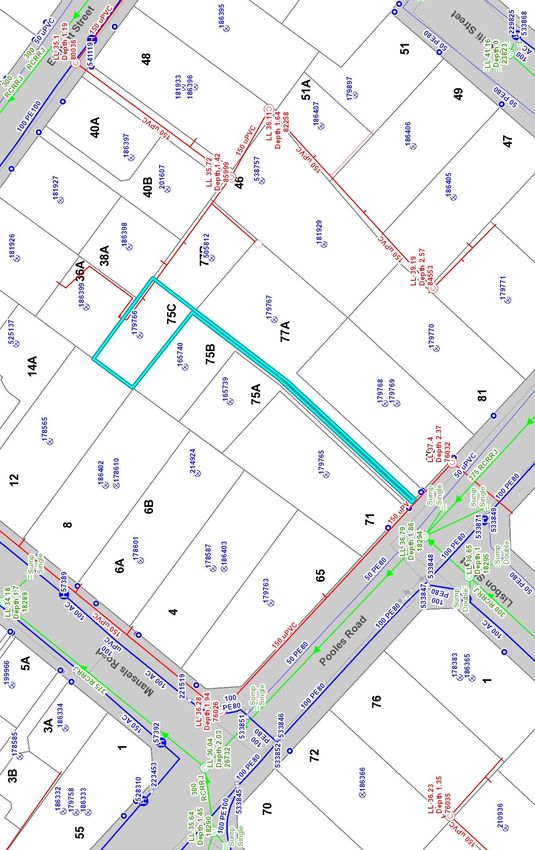
Property Address 75C Pooles Road
Greerton
Tauranga
Legal Description Lot 3 DP 381645
Application Date 26 March 2021
This Land Information Memorandum has been prepared for the purposes of Section 44A of the Local
Government Official Information and Meetings Act 1987 and, in addition to the information provided for under
section 44A(2), may contain such other information concerning the land that Council considers, at its
discretion, to be relevant. It is based on a search of Council records only. There may be other information
relating to the land which is unknown to Council. The Council has not undertaken any inspection of the land
or any building on it for the purpose of preparing this Land Information Memorandum. The applicant is solely
responsible for ensuring that the land is suitable for a particular purpose.
It is recommended that the Certificate of Title, which is not held by Council, be searched by the purchaser.
Contents
Services Information
Rating and Valuation Details
Building Information ▪ Consents and Permits
▪ Requisitions
Land Development ▪ City Plan
▪ Resource Consents
▪ Land Features
▪ Hazardous Contaminants
Other Information ▪ Licences
Tauranga City Council
www.tauranga.govt.nz │ 91 Willow Street, Tauranga 3110 │ Private Bag 12022, Tauranga 3143 │ Phone 07 577 7000 │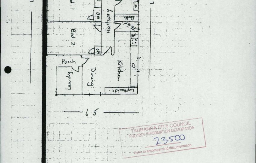
2

Services Information
Land information which is likely to be relevant includes information on private and public
stormwater, water and sewer details. Please refer to the appropriate authorities for further
information about network utility services.

 Service Record
 Copy of Deposited Plan Attached                                Yes

 Service Print Attached                                         Yes

 Method of Sewer Disposal                                       To Public Sewer

 Existing Method of Stormwater Disposal                         Soakholes

 Drinking Water Supplied to the Land                            Yes

 Drinking Water Supplier Is:
 (I)    Owner of the Land; or                                   No Information Available
 (ii)   Tauranga City Council [Water Supply Authority           Yes
        Unit (WSA)]; or
 (iii) Another Networked Supplier                               No Information Available

 Any Information Notified Under Section 69ZH Health
                                                                No Information Available
 Act 1956

Note:
1.       Cross Lease situations differ to Freehold Titles in that any building additions to the
         property in question may need to have the cross lease plan updated. Any
         unregistered changes could be regarded as not legally part of the lease. For
         information regarding the updating of a cross lease plan please contact a Surveyor or
         your Solicitor.
2.       Please note that the existence of a watermain along a property frontage does not
         necessarily mean that a connection is available. This may need to be provided at the
         applicant’s expense.
3.       If the land is supplied with drinking water by Tauranga City Council as a Water Supply
         Authority, any conditions (generally set out in Tauranga City Council’s “Supply of
         Water Bylaw 2019” – copy attached) applicable to that supply are included in this
         Land Information Memorandum.
4.       If the land is supplied with drinking water by a networked supplier other than the
         WSA, any conditions that are applicable to that supply are included in this Land
         Information Memorandum.
5.       If the land is supplied with drinking water by the owner of the land, any information
         Council has about the supply is included in this Land Information Memorandum.
6.       Any information notified to the territorial authority by a drinking-water supplier under
         section 69ZH of the Health Act 1956 is included in this Land Information
         Memorandum.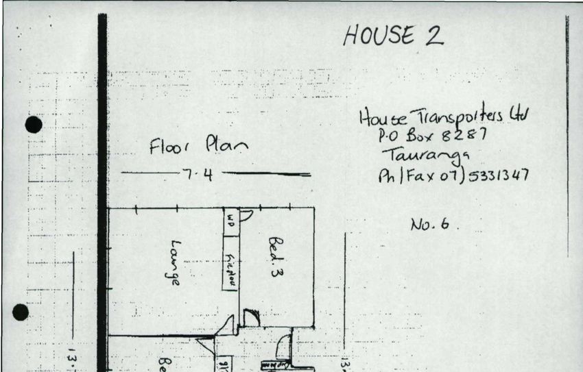
3

Rating and Valuation Details
Tauranga City Council rates are billed twice a year on the last business day of August and
February. Unpaid rates for each instalment will incur a 10% penalty. A further 10% arrears
penalty will be added in July and January on any rates balance that remains outstanding after
30 June of each rating year. The Capital Valuation details are based on a revision date of 1
July 2018.

Valuation Details

Valuation Reference                                            06615 284 06

Capital Value                                                  $425,000

Land Value                                                     $285,000

Improvement Value                                              $140,000

Rating Details

Current Annual Rates                                           $2,257.08

Paid Until                                                     30/06/21

Arrears Owing                                                  $Nil

Balance Owing                                                  $Nil

A separate account is issued for water metered properties. Residential meters are read every
three months. Commercial / Industrial meters vary depending on use.

Note:
Please arrange for a final water meter reading prior to date of possession.

Water Meter Details

Water Meter On Property                                        Yes

Date Read                                                      27/02/21

Number                                                         19M188136

Last Reading                                                   00143

Individual Meter                                               Yes

Shared Meter                                                   No

Water Rates Owing                                              $Nil
4
Building Information
This information is sourced from Council records and may not reflect the situation on site if
work has been undertaken without consent.
Building Permits: For Building Permits issued prior to 1993 a copy of the inspection records,
if these are held by Council, are attached.
Building Consents: For Building Consents issued after 1 January 1993 a Code Compliance
Certificate (CCC) will be issued where the building work for which the building consent relates
has been completed in accordance with the NZ Building Code.
Swimming / Spa Pools: If the property contains a swimming pool or spa pool that is filled or
partly filled with water then the pool must have a physical barrier restricting access to the pool
that meets the requirements of the Building Act 2004. For more information, go to
www.tauranga.govt.nz/council-a-z/swimming-pool-fencing.aspx.
Solid Fuel Heaters: It is important that any solid fuel heater has been legally installed, either
as part of the original dwelling or by way of a separate permit/consent.
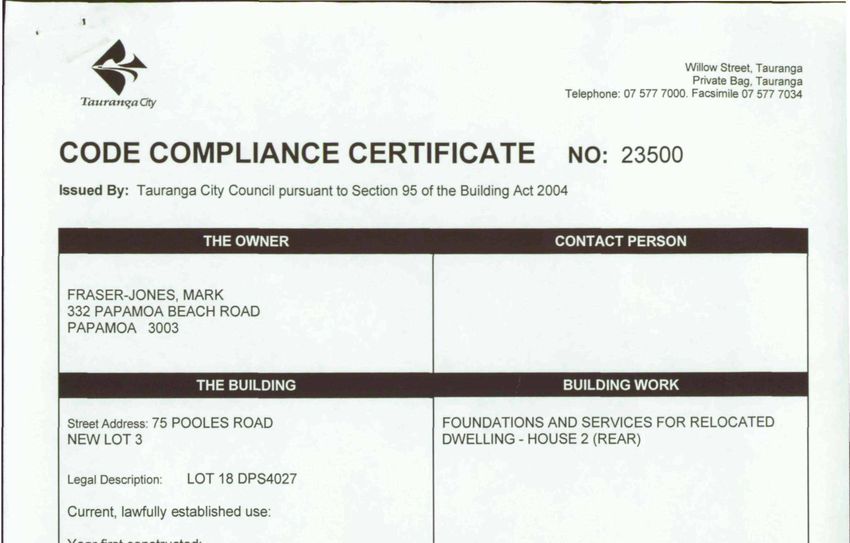
Permits and Consents
Building Consents
BC CCC
Date Issued Description of Work Number Issued
23/11/06 Foundations and services for relocated dwelling 23500 Yes
– house 2 (rear)
Compliance Schedule N/A
Requisitions
Any Outstanding Requisitions No
5

City Planning
The Operative Tauranga City Plan

The Operative Tauranga City Plan (City Plan) is a document that regulates all subdivision,
use and development across the City. It also covers how and where the City grows, how
infrastructure is located and how natural and physical resources are managed. It is the
blueprint by which any development in Tauranga is managed.
There are specific rules within the City Plan that cover, amongst other matters, building
height, earthworks, tree protection, bulk and scale of buildings, setbacks from coastal and
harbour margins, and specific residential, commercial and industrial uses depending on
location within the City.

Specific rules for each suburb and property can vary depending on the underlying zone of the
area and the location of a specific property within that zone.

The majority of the City Plan became ‘operative in part’ on 9 August 2013. The remaining
parts of the City Plan subsequently became operative on 5 July 2014.

It is advised that prospective purchasers of property review and consider all relevant planning
rules for the specific property this Land Information Memorandum applies to prior to purchase.

Copies of the planning maps for the Operative Tauranga City Plan are included in this LIM.

To view the Operative Tauranga City Plan please visit the Tauranga City Council website
www.tauranga.govt.nz.

If you have any specific queries on any rules or any existing or proposed use of a property
please contact the Tauranga City Council’s Duty Planner (07 577 7000) for further
information.

Development Contributions
Council operates a development contributions policy under the Local Government Act 2002,
and also has financial contributions provisions in its City Plan. The broad purpose of these
policies is to fund infrastructure costs that relate to the city’s growth from those parties that
undertake subdivision, building or development. These contributions are required on building
consents, resource consents, service connection authorisations and certificates of
acceptance. Contributions may remain payable on any property in circumstances where
subdivision, building and development projects have not been completed, and in rare
occasions where the Council has agreed to defer payment. In addition, further subdivision,
building or development of a property may trigger the requirement to pay further development
and/or financial contributions.

Council’s development contributions team can advise further on these matters in relation to
the application of development and financial contributions to the property in question.

Integrated Transportation Strategy and Reserve Management
Plans
“As part of Tauranga City Council’s Integrated Transport Strategy and Reserves Management
Plans, properties neighbouring Council-owned or administered land may be subject to
walkway and cycleways development or other development, activities or use of the land. The
Tauranga Reserves Management Plan is available online at
http://www.tauranga.govt.nz/council/council-documents/strategies-plans-and-
reports/plans/reserve-management-plans”

6

Special Housing Areas
Special Housing Areas are sites in the city that are suitable for new housing and able to be
developed fast to increase housing supply. Development of these sites can be fast-tracked
under the Housing Accord and Special Housing Areas Act 201, through an accelerated
resource consenting process.

Special Housing Areas are proposed by landowners / developers, considered by Council and
if supported by Council, submitted to the Minister of Building and Construction for a final
decision. Under the current Housing Accord, Council and the Government will be able to
consider applications for new Special Housing Areas up until September 2019.

Special Housing Areas will only be established in areas where there is a clear demand for
housing, and where there is already suitable infrastructure in place (e.g. roads, wastewater
systems, water supply pipes), or plans for it to be built.

For more information on Special Housing Areas including detail on any Proposed and Active
sites with the Tauranga area https://www.tauranga.govt.nz/our-future/enabling-
growth/housing-accord-and-special-housing-areas

Relevant Planning Information

Zone: Operative Tauranga City Plan                           Suburban Residential
                                                             Plan Attached

Identified Plan Areas                                        None Known

Designations                                                 None

Protected Heritage/Notable or Groups of Trees, or            None Known
Protected Buildings

Archaeological or Heritage Sites                             None Known

Council Consents, Certificates, Notices, Orders or           Yes
Bonds Affecting the Land:

Resource Consents (Resource Management Act 1991)

Description                                                Date Granted           RC Number

Resource Consent                                           06/11/06               13035

Resource Consent                                           06/11/06               13038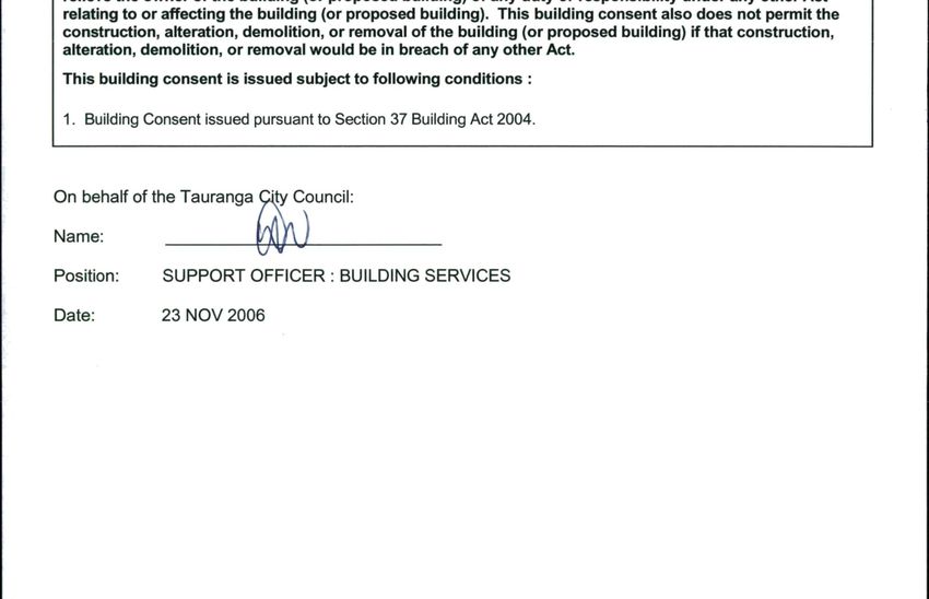
7

Additional Planning Information
Three plan changes are in the formal plan change process under Schedule 1 of the Resource
Management Act 1991, with the public notification period for submissions between 16
November and 1 February 2021 and further submissions in early 2021. The proposed
amendments are available to be viewed within the City Plan.

This property is affected by:

Plan Change 26 (Housing Choice) – Proposed Plan Change 26 seeks to enable greater
housing choice and density to respond to the demands of increased population, changing
demographics and an aging population in existing urban areas.

    •   This property is located within the proposed Te Papa Housing Overlay where the
        Housing Choice Plan Change is proposing to enable greater intensification and
        building heights

    •   This property is located within the Suburban Residential Zone where the Housing
        Choice Plan Change is proposing to enable a greater choice of housing, including
        duplexes and townhouses.

Online maps are also available showing the zoning, Te Papa Housing overlay and the natural
hazards overlay: www.tauranga.govt.nz/floodmaps

For further information on the            Proposed     Plan    Change     26,   please     visit:
www.tauranga.govt.nz/planchanges

Plan Change 27 (Flooding from Intense Rainfall Events) – Proposed Plan Change 27
seeks to reduce the risk of flooding to life, property and infrastructure from intense rainfall
events in Tauranga. The proposed policy and rule framework will be used to determine the
type and location of land use on land subject to flooding in a 1-in-100 year rainfall event,
which takes into consideration the effects of sea level rise and climate change as of the year
2130. Mapping has been completed for such a flooding event and will supersede related
existing flood mapping that Tauranga City Council holds from 16 November 2020. Please see
attached related correspondence and map which illustrates the effect on this property.

Click here for site specific map

Online maps area also available showing the location and extent of the flooding:
www.tauranga.govt.nz/floodmaps

Proposed Plan Change 27 has legal effect from Monday 16 November 2020. This means that
all applications, where required, have regard to the proposed objectives, policies and rules
from the date of public notification.

For   further  information   on        Proposed      Plan     Change    27,     please     visit:
www.tauranga.govt.nz/planchanges

Plan Change 30 (Earthworks) – Proposed Plan Change 30 seeks to make minor
amendments to existing earthworks rules in the City Plan to address issues arising in relation
to the control of earthworks at all stages of development and managing sediment on sites.

For   further  information   on        Proposed      Plan     Change    30,     please     visit:
www.tauranga.govt.nz/planchanges

Historical Flood Modelling (Pre 2020 1% AEP without climate change / sea level rise) can
also be viewed here

If you have any enquiries about the proposed Plan Changes you can call Tauranga City
Council on 07 577 7000 or e-mail us at info@tauranga.govt.nz.
8

Land Features
This information relates only to details held on Council files and may not reflect the on site
situation.

The Tauranga City Council does not act as agent for network utility operators.

The land form and geology within Tauranga City have some features which demand particular
attention. These features, which may or may not be relevant to the property in question, are
outlined in “General Description of Land Form within Tauranga District” as attached.

Microzoning for Earthquake Hazards

The Council has received reports and results that have assessed Tauranga City’s
vulnerability to liquefaction when considering a range of earthquake events. These reports
and     results,    and     a   summary     of   them,    are   available   by    accessing
https://www.tauranga.govt.nz/living/natural-hazards/understanding-our-hazards-studies-
maps-and-data/earthquakes-and-liquefaction

The reports and results reflect the most up-to-date vulnerability to liquefaction from an
earthquake event.

It is important to note that different properties are exposed to different levels of probability that
land damage from liquefaction and lateral spread will in fact occur. The reports and results
are undertaken at a City-wide scale and may be superseded by detailed, site specific
assessments undertaken by qualified and experienced practitioners using improved or higher
resolution data than presented in these reports.

The vulnerability and land damage maps are prepared based on an assessment of natural
ground conditions and therefore do not take into account the influence of recent human
activities that may influence liquefaction response (i.e. earthworks, ground improvement,
foundation design), unless specifically stated within the technical reports. As such, the degree
of land damage may be less than predicted for a given property where liquefaction risk was
addressed during landform or building foundation design.

The presence of liquefaction and lateral spread information on a property may have
implications for the use and development of that property including, but not limited to, the
requirements for and assessments of building consent applications under the Building Act
2004 and Building Code (refer to the NZ Standard AS/NZ 1170 and design standard outlined
in Chapter 10.10.6 Liquefaction of Tauranga City Council’s Infrastructure Development Code),
subdivision consent applications under the Resource Management Act, and infrastructure
design.

The assessed hazard applicable to the area this property has been assessed within, is
available by accessing the web-viewer available through the following link:
https://www.tauranga.govt.nz/living/natural-hazards/understanding-our-hazards-studies-
maps-and-data/earthquakes-and-liquefaction
9

Special Land Features Relevant to the Subject Property
Yes

Comments:

Please see flood risk assessment information related to Plan Change 27 under
planning section of this report.

Additional Information
Licences

Licences Affecting the Land or Buildings                         No

Signed for and on behalf of the Council:

Position held: Technical Advisor

Date: 9 April 2021
Rates Information
Location                           75C POOLES ROAD
Valuation Ref                      06615 284 06
Legal Description                  LOT 3 DP 381645
Area                               0.0385
Land Value                         285,000
Capital Value                      425,000

Total rates assessed this year

       Tauranga Council                  Units                Rate          Annual            Regional Council    Units       Rate         Annual
                                                                            Amount                                                         Amount

  Uniform Annual General                               1   257.39130435           257.39   Regional General       285,000     0.00020788      59.25
  General                                        425,000     0.00199919           849.66   Regional UAGC                1   125.81739130     125.82
  Resilience Targeted Rate                       425,000     0.00001864             7.92   Passenger Transport          1   168.61739130     168.62
  Wastewater Connected                                 1   439.80869565           439.81   Rate                         1    21.75652174      21.76
  Glass Recycling                                      1    32.46956522            32.47   Civil Defence (CDEM)                              375.45
  Total                                                                         1,587.25   Total

                                                              Includes GST of                                                                $294.38

                                                              Total Rates (01 JUL 2020 to 30 JUN 2021)                                      $2257.08

Water Rates
Metered A/C # 6              Route # M      Class #        Rate: 0         /m3       Supply Area: METERED WATER

What are rates?
The amount you pay in rates doesn’t directly relate to the amount of things Council does for you personally. Rates are not a
‘charge for services’, they are a tax on the value of your property. It is not a perfect system but it is one of the very few ways the
Government allows Councils to collect revenue. Rates provide 55% of the Council’s income.

Rates Information
The rating year starts on 1 July each year to 30 June the following year.
•         Rates and charges are inclusive of GST.
•         Annual Rates are set in July each year.
•         Rates are payable in two instalments and are paid in advance.

Each year an assessment is sent out to property owners on 1 August together with the first instalment invoice. Payments are due
on the last working day in August. The second instalment invoice is sent out to property owners on 1 February each year and is
due on the last working day of February.

What are the charges for rates and how are they calculated?
Rates are a tax on the value of your property. The value of your property is set by an independent agency and is driven by national
legislation. Revaluations are done every three years.

What do General Rates pay for?
Rates are used to pay for a wide range of services and capital projects such as new roads, storm water, libraries, reserves and so
on. Councils ten year plan is a good place to find out more about how Council plans to spend rates income. Tauranga City collects
rates on behalf of the regional council also.
Tauranga City Rates Schedule 2020/21
Description Inclusive of GST Charge
Uniform Annual General $296.00 per occupancy
Wastewater $505.78 per residential property or per connection for
commercial
Wastewater Availability $252.89 per property
District Residential $0.00229907 Capital value
District Commercial $0.00275888 Capital value
City Mainstreet $0.00051999 Capital value
Greerton Mainstreet $0.00171421 Capital value
Papamoa Mainstreet $0.00034526 Capital value
Mount Mainstreet $0.00082296 Capital value
Economic Development $0.00051443 per commercial property
The Lakes $83.89 per property in the subdivision
Papamoa Coast $35.21 per property in the subdivision
Excelsa $48.20 per property in the subdivision
Resilience $0.00002144 Capital value
Glass collection $37.34 per residential property
Uniform Annual General Rates (UAGC)
This is a fixed charge per rateable property and is irrespective of the value of a property. For residential properties it is a
charge per occupancy.
Each occupancy is defined by physically having a separate living area, bedroom, bathroom facilities, entrance (including
shared foyers) and cooking facilities. E.g. a property with a self contained flat on the ground floor would be rated for two
UAGC’s and two wastewater connections.
(Note: This rate is not based on ability to earn revenue or rent, frequency of use or the relationship of person/s using or able
to use the separate area. This does not relieve the owner or occupier of any duty or responsibility under the Building Act 2004
or the Resource Management Act 1991 or the Tauranga City Plan) For commercial properties this is a charge on the number
of separate businesses or leases.
General Rate
This variable rate is charged on the capital value of a property. Capital value is land value plus improvements value.
Wastewater Rates
Residential properties connected to Council wastewater pay a uniform annual charge for one toilet per occupancy.
Commercial properties connected to Council wastewater pay a uniform annual charge for each toilet or urinal.
Those properties with wastewater available (i.e. they are within 100m of wastewater lines) but not connected will pay an
availability charge.
The Lakes, Papamoa Coast and Excelsa Targeted Rate
This rate is charged on the capital value of a property. Capital value is land value plus improvements value. The Lakes
Development at Tauriko/Pyes Pa and Papamoa Coast and Excelsa developments at Papamoa have significantly increased level
of service costs as a result of wider roads, more gardens, reserves and streetlights etc. All properties in these subdivisions are
charged this targeted rate.
Economic Development Rate
This rate is charged on the capital value of a property.
It is charged to commercial properties only and funds economic development through Priority One and Tourism Bay of
Plenty.
Mainstreet Rates
This rate is charged on the capital value of a property. It is charged to commercial properties only and funds the Tauranga,
Papmoa, the Mount and Greerton Village Mainstreet organisations.10 November 2020
Clive Joseph Poultney
585 MCLAREN FALLS ROAD
RD 1
TAURANGA 3171
Dear Sir/Madam
Proposed Plan Changes to the operative Tauranga City Plan
Tauranga City Council is currently progressing the following plan changes to the operative
Tauranga City Plan (City Plan):
Proposed Plan Change 26 (Housing choice)
This plan change proposes changes to the City Plan to make it easier for people to
build a variety of more compact types of homes, like duplexes, terraced houses,
townhouses and apartments, to better suit their needs.
Proposed Plan Change 27 (Flooding from intense rainfall events)
This plan change introduces a new rule framework to manage the effects of flooding
in intense rainfall events on people, properties and infrastructure.
Proposed Plan Change 30 (Earthworks)
This plan change proposes to clarify wording of existing provisions to ensure that
earthworks are undertaken in a safe manner, avoiding negative effects on the
environment.
As the owner of the property at 75C POOLES ROAD, you have been identified as likely to
have an interest in the changes proposed for the following reasons.
Your property is located within the proposed Te Papa housing overlay where the housing
choice plan change is proposing to enable greater intensification and building heights.
Through proposed Plan Change 27, mapping has been updated and will supersede existing
flood hazard mapping that Tauranga City Council holds. Your property has been identified
through the flooding from intense rainfall plan change as being in a potentially floodable area
(such as overland flowpaths, floodplains or flood prone areas) and may be subject to
additional rules for any future works on the site. Proposed Plan Change 27 will have legal
effect from Monday 16 November 2020. This means that all applications, where required,
should have regard to the proposed objectives, policies and rules from the date of public
notification.-wide changes through Plan Change 30 (Earthworks) to
improve existing rules for the control of earthworks at all stages of development (subdivision
and post-subdivision), and sediment and erosion control.
Where to find more information
To help you understand the proposed plan changes and how they affect your property, the
following information is available at www.tauranga.govt.nz/planchanges
customer service centre and your local library:
- public notice as published in the Weekend Sun on Friday 30 October 2020 and Bay
of Plenty Times Saturday 31 October 2020;
- annotated text showing the proposed changes to the City Plan and section 32
evaluation reports explaining the reasons for the proposed changes;
- online map viewer showing the location and extent of the plan change areas,
including the City Plan zoning and flooding on your property;
- submission form to make a submission.
If you rent or lease your property, please ensure you notify your tenant or lessee about the
contents of this letter.
These proposed plan changes have been initiated under the provisions of Schedule 1 of the
Resource Management Act 1991.
Community open days
If you wish to discuss the proposed plan changes, please join us at one of the community
open days listed below.
If you have specific questions about how your property is affected by proposed Plan Change
27 (Flooding from intense rainfall), we recommend booking a private appointment with our
team at one of the community sessions listed below. Book online at
www.tauranga.govt.nz/planchanges or call (07) 577 7000.
Date Time Location
Monday, 23 November 3pm to 6pm Greerton Library, 139 Greerton Road
Tuesday, 24 November 3pm to 6pm Arataki Community Centre, Zambuk
Way
Wednesday, 25 November 3pm to 6pm Otumoetai Golf Course, 25 Bureta
Road
Thursday, 26 November 3pm to 6pm Council offices, 91 Willow Street
Friday, 27 November 3pm to 6pm Bethlehem Hall, 239A State Highway 2
Saturday, 28 November 9am to 12.00pm Tauriko Hall, 776 State Highway 29
Monday, 30 November 3pm to 6pm Papamoa Community Centre, 15
Gravatt Road
Tuesday, 1 December 3pm to 6pm Mount Rugby Club, 49 Miro Street
Thursday, 3 December 3pm to 6pm St Stephens Church, 15 Brookfield
Terrace
Friday, 4 December 3pm to 6pm Welcome Bay Community Centre, 242
Welcome Bay RoadMaking a submission
Submissions on proposed plan change 26, 27 or 30 must be lodged in writing and either
submitted online at www.tauranga.govt.nz/planchanges, emailed to
city.plan@tauranga.govt.nz or posted to:
Manager: City and Infrastructure Planning
Tauranga City Council
Freepost Authority Number 370
Private Bag 12022
Tauranga 3143
Submissions are open until 5pm, Friday, 18 December 2020
The submission should be in the format of Form 5 of the Resource Management (Forms,
Fees and Procedure) Regulations 2003 and must be dated and signed by you and include
the following information:
(a) Your name, address, telephone and email address.
(b) The plan change number and details of the provisions to which the submission is
being made.
(c) Whether you support or oppose the plan change provisions, in whole or in part.
(d) Reasons for your support or opposition.
(e) The decision you wish Tauranga City Council to make.
(f) Whether you wish to be heard in support of your submission.
(g) Whether or not you could gain advantage in trade competition through your
submission.
For further information regarding the details of the amendments introduced by the proposed
plan changes contact us on (07) 577 7000 or email city.plan@tauranga.govt.nz.
Yours sincerely
Janine Speedy
Team Leader: City PlanningGeneral Description of Land Form within Tauranga District
The land form and geology within Tauranga District have some features which demand particular attention.
(a) Minimum Building Platform Levels
Significant areas of Tauranga District are at risk of flooding through sea level rise, tidal surges within the
harbour, storm-wave runup on the ocean coastline and the flooding of streams, sewer drains, ponding areas
and overland flow paths in extreme climatic conditions. Council has some “broadbrush” information on many
possibly flood prone areas. More detailed investigations by appropriately qualified people may be required to
be submitted in support of Resource and Building consents. Building Platforms should be constructed with
adequate freeboard above flood levels. Council has adopted a minimum floor level policy. This level is
available from Council on request from Council’s Development Engineer. However due to the dynamic nature
of the environment and the ongoing investigative work these levels may be reviewed at any time. For the
purposes of this clause, a “building platform” is defined as the area of ground within a line 1.0m outside the
perimeter of the building proper.
(b) Low-lying Land
There are many areas of low-lying land (often adjacent to the harbour) which comprise soft or very soft
foundation conditions. These conditions are characterised by normally consolidated fine grained alluvial
sediments (silts and clays) which have been deposited in marine or estuarine environments. In many areas
they have been subject to random and non-engineered fillings. The materials are prone to settlement caused
by consolidation under even minor loadings. These areas require particular care and appropriate geotechnical
investigation and advice prior to development concepts being prepared. Whilst most of the Mount
Maunganui/Papamoa area has an underlying sand formation, pockets of peat and “black sand” occur which
exhibit poor foundation support qualities. These should be removed from building platforms and roading
subgrades.
(c) Sloping Ground
The foundation conditions of the low-lying areas in the District have been described in (b) above. The near
surface geology of the higher ground within the District comprises a series of weathered fine grained rhyothic
ashes known locally as the Older Ashes. The Older Ashes consist of the Pahoia Tuffs overlain by the Hamilton
Ash (the top of which is known locally as the “chocolate” layer).
Overlying the Older Ashes is a series of coarse friable silts, sands and pumice lapilli which tends to mantle the
topography formed within the Older Ashes and are known locally as the Younger Ashes.
On some sloping ground, particularly the present and relic slips adjacent to the harbour, the ashes often have
marginal stability and there are numerous examples of past and recent instability. Deep seated failures are
generally confined to the steep banks which are or have in their history been subjected to active toe erosion.
Development must be set back from the top of such steep banks, with the set back distance being determined
by appropriate geotechnical investigations carried out by a Person who has pre-qualified with Council as a
Specialist Geotechnical Advisor.
The majority of other failures on modest to steeply sloping ground are shallow failures (involving the top 1m to
3m of soil), but are nonetheless of serious consequence to any building development. Such failures are usually
initiated by extreme climatic conditions. Any sloping ground greater than 15 degree gradient should be
subject to appropriate geotechnical investigations to determine whether the ground is adequately stable for
development.You can also read