January 2023 Tennessee State Climate Summary
←
→
Page content transcription
If your browser does not render page correctly, please read the page content below

January 2023 Tennessee State Climate Summary

      January 2023 Tennessee State Climate Summary
                      Tennessee Climate Office * East Tennessee State University
                         Prepared by William Tollefson and Dr. Andrew Joyner
                  With contributions by Climate Data Representatives across the state

Monthly Temperature Summary:
January was much warmer than normal across Tennessee, with the majority of the state recording a mean
temperature that was 4-8°F above the 1991-2020 30-year climate normals for the month. Three counties
in northwest Tennessee, Lake, Obion, and Dyer, all recorded their warmest mean temperature for the
month of January. The month started out on a warm note, with most areas reaching into the mid-70’s on
the first three days of January. Chattanooga and Jackson set daily high temperature records on January 2,
with Nashville tying their daily high temperature record, and on January 3 Knoxville and the Tri-Cities set
daily high temperature records. The first week of the month averaged 12-15°F warmer than normal across
most areas of the state. While later weeks in the month were not as extreme, the warmer than normal
pattern continued. Another notable warm spell occurred January 17-19, with Jackson setting and
Memphis tying daily record highs on the 18th, and Chattanooga and the Tri-Cities setting daily record highs
on the 19th. Looking at all stations with at least a 30-year reporting history, there were 35 broken daily
high temperature records, and 17 broken records for warmest daily low temperature this month. The
weather station at Monterey set a monthly record for warmest low temperature ever recorded in January.

                                                                                                         1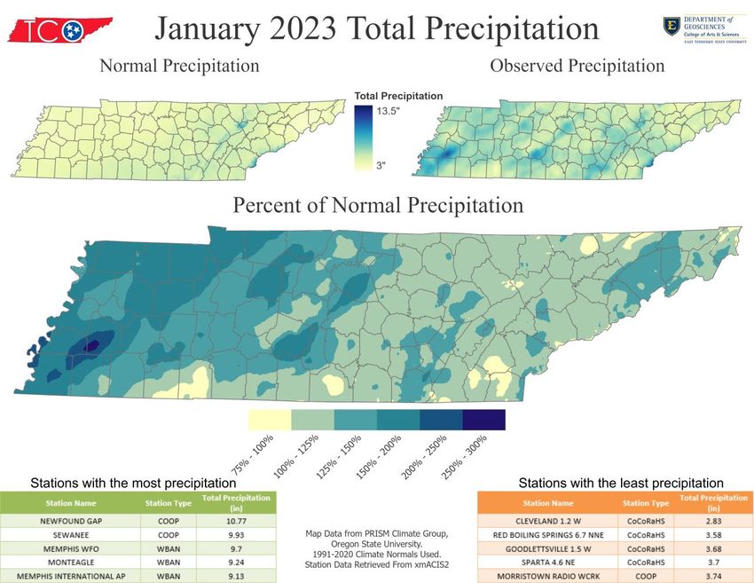
January 2023 Tennessee State Climate Summary

Monthly Precipitation Summary:
Most areas of the state recorded above normal precipitation for January 2023, with the western half of
the state generally seeing the most above normal precipitation totals Southwestern portions of Haywood
County recorded over 250% of their normal precipitation for the month. This wet pattern started out in
the first week of the month, with almost all of West Tennessee recording more than double their normal
rainfall for the week. The heavy rainfall shifted to East Tennessee for the second week of the month with
over 2” of rain in the mountains and northern Tennessee Valley. The mountains also received heavy
snowfall in the middle of the month, with up to a foot of snow recorded across the highest elevations.
Precipitation totals were not as high in the second half of the month, but frequent light rain occurred
across the state. At the very end of the month, freezing rain, sleet, and a little snow impacted West and
Middle Tennessee, with ice storm warnings and winter weather advisories being issued on January 31.
Throughout the month there were 34 records set for largest daily precipitation, with just over half set in
the first week of January.

                                                                                                        2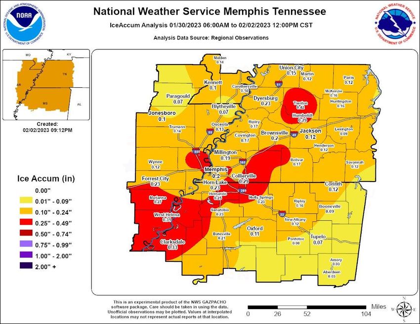
January 2023 Tennessee State Climate Summary

Station Data and Top Tenn. (warmest/wettest, coldest/driest stations of the month):
Station data for airports across the state using WBAN weather stations, compared to 1991-2020 30-year
climate normals for departure from mean temperature and total precipitation:
 Station Name                           Temperatures (˚F)                                Precipitation (inches)
                          Averages                            Extremes                          Totals
                Max    Min      Mean    Depart    High      Date      Low    Date      Obs     Depart     %Norm
   Memphis      56.7   39.9     48.3     +6.2      74        1/1      25     1/31      9.13    +4.99       221%
   Jackson      55.1   35.8     45.4     +6.4      73        1/1      23     1/24      6.27    +2.20       154%
  Clarksville   55.1   36.0     45.5     +8.5      75        ½        23     1/21      5.42    +2.14       165%
   Nashville    56.4   37.2     46.8     +7.2      75        ½        25     1/27      4.91    +0.89       122%
 Chattanooga    57.2   39.2     48.2     +6.5      72        1/3      27     1/24      5.57    +0.55       111%
   Crossville   50.7   33.7     42.2     +6.9      66        1/3      19     1/15      6.13    +1.18       124%
   Knoxville    53.4   36.4     44.9     +5.8      75        1/3      23     1/15      6.23    +1.47       131%
    Bristol     53.6   32.6     43.1     +6.7      75        1/3      17     1/15      4.45    +0.80       122%
Departures and %Norm Key: Warmer than Normal, Cooler than Normal; Wetter than Normal, Drier than Normal
                           Hottest Stations (highest maximum temperature)
                                                                           Highest
                                                            Station
                              Station Name                               Temperature    Date
                                                             Type
                                                                             (F)
                               KINGSTON                     COOP             82          12
                          JACKSON EXP STA                   COOP             76           2
                             NEWPORT 1 NW                   COOP             76           3
                         MORRISTOWN WFO                     COOP             76           3
                          AMES PLANTATION                   COOP             76           2
                       SHILOH NMP TENNESSEE                 RAWS             76           1
                              ELIZABETHTON                  COOP             75           4
                               LOBELVILLE                   COOP             75           2
                        NASHVILLE BERRY FIELD               COOP             75           3
                       BOLIVAR WATER WORKS                  COOP             75           2
                       CLARKSVILLE OUTLAW AP                WBAN             75           2
                          NASHVILLE INTL AP                 WBAN             75           2
                              KNOXVILLE AP                  WBAN             75           3
                              BRISTOL AP                    WBAN             75           3
                                                        rd
                           Eight stations tied for the 3 hottest temperature (75°F)

                                                                                                                  3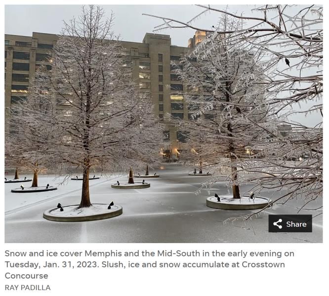
January 2023 Tennessee State Climate Summary

                           Coldest Stations (lowest minimum temperature)
                                                                        Lowest
                                                         Station
                            Station Name                              Temperature       Date
                                                          Type
                                                                          (F)
                            MT LECONTE                    COOP             5            27
                       ROAN MOUNTAIN 3SW                  COOP             8            16
                          MOUNTAIN CITY 2                 COOP             12           16
                             KINGSPORT                    COOP             12           26
                          NEWFOUND GAP                    COOP             12           28
                         PICKETT STATE PARK               COOP             14           16
                             TAZEWELL                     COOP             15           16
                         CLARKSVILLE WWTP                 COOP             15           22
                             ERWIN 1 W                    COOP             16           17
                        GREENEVILLE EXP STA               COOP             16           15

                           Warmest Stations (highest mean temperatures)
                                                                       Mean Temperature
                            Station Name              Station Type
                                                                              (F)
                       SHILOH NMP TENNESSEE               RAWS               49.1
                    MEMPHIS INTERNATIONAL AP              WBAN                  48.3
                         CHATTANOOGA AP                   WBAN                  48.2
                          JACKSON EXP STA                 COOP                  47.6
                           MC MINNVILLE                   COOP                  47.6
                     FAYETTEVILLE WATER PLANT             COOP                  47.4
                           MEMPHIS WFO                    WBAN                  47.4
                       NASHVILLE BERRY FIELD              COOP                  46.9
                         BURNS TENNESSEE                  RAWS                  46.9
                         AMES PLANTATION                  COOP                  46.8
                        MOUNT PLEASANT 1N                 COOP                  46.8
                         NASHVILLE INTL AP                 WBAN                46.8
                        Three stations tied for the 10th warmest temperature (46.8°F)
                             Coolest Stations (lowest mean temperatures)
                                                                       Mean Temperature
                            Station Name               Station Type
                                                                              (F)
                            MT LECONTE                    COOP               29.6
                          NEWFOUND GAP                    COOP                  35.5
                        ROAN MOUNTAIN 3SW                 COOP                  38
                          MOUNTAIN CITY 2                 COOP                  38.6
                             KINGSPORT                    COOP                  40.1
                             TAZEWELL                     COOP                  40.7
                          ROGERSVILLE 1 NE                COOP                  40.8
                           MAYNARDVILLE                   COOP                  41.2
                               ONEIDA                     COOP                  41.3
                             ERWIN 1 W                    COOP                  41.4

                                                                                               4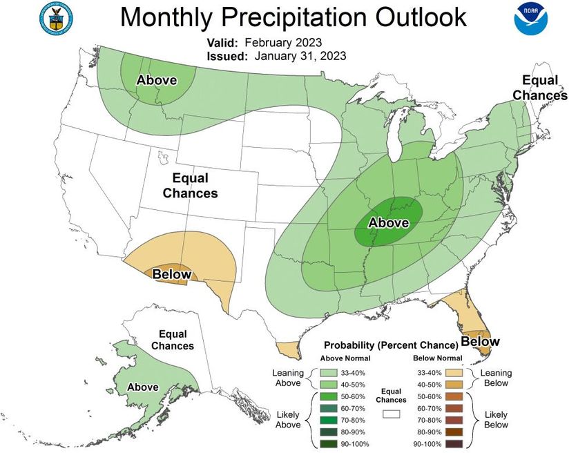
January 2023 Tennessee State Climate Summary

                             Wettest Stations (highest precipitation totals):
                                                                         Total Precipitation
                             Station Name               Station Type
                                                                                 (in)
                           NEWFOUND GAP                     COOP                10.77
                               SEWANEE                      COOP                9.93
                            MEMPHIS WFO                     WBAN                9.7
                             MONTEAGLE                      WBAN                9.24
                     MEMPHIS INTERNATIONAL AP               WBAN                9.13
                             BROWNSVILLE                    COOP                9.09
                             ROCKWOOD 2                     COOP                8.41
                             DECATURVILLE                   COOP                 8
                             WAYNESBORO                     COOP                7.98
                             MT LECONTE                     COOP                7.95

                              Driest Stations (lowest precipitation totals):
                                                                         Total Precipitation
                             Station Name               Station Type
                                                                                 (in)
                           CLEVELAND 1.2 W                CoCoRaHS              2.83
                     RED BOILING SPRINGS 6.7 NNE          CoCoRaHS              3.58
                        GOODLETTSVILLE 1.5 W              CoCoRaHS              3.68
                            SPARTA 4.6 NE                 CoCoRaHS              3.7
                      MORRISTOWN RADIO WCRK                 COOP                3.74
                        MURFREESBORO 4.3 SE               CoCoRaHS              3.82
                           FAIRVIEW 1.9 ENE               CoCoRaHS              3.85
                           KYLES FORD 1.0 N               CoCoRaHS              3.91
                        BELLE MEADE 5.3 WSW               CoCoRaHS              3.94
                       HENDERSONVILLE 4.9 NNE             CoCoRaHS              3.96

                          Snowiest Stations (highest snowfall accumulations)
                                                                             Total Snowfall
                                 Name                     Station Type
                                                                                   (in)
                             MT LECONTE                       COOP                  22
                           NEWFOUND GAP                       COOP                   11
                           PIKEVILLE 7.5 SW                 CoCoRaHS              9.1
                        ROAN MOUNTAIN 7.1 W                 CoCoRaHS              3.9
                        ROAN MOUNTAIN 3SW                     COOP                   3
                          JAMESTOWN 3.1 SE                  CoCoRaHS              2.5
                          JAMESTOWN 12.9 S                  CoCoRaHS              1.9
                               SEWANEE                        COOP                1.7
                           MOUNTAIN CITY 2                    COOP                1.6
                          CLARKRANGE 6.0 NE                 CoCoRaHS              1.5
                               TAZEWELL                        COOP                1.5
                     54 of 351 stations in the state reported measurable snowfall and an
                             additional 64 reported a trace of snow this month.

                                                                                               5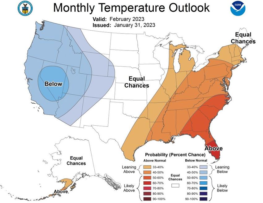
January 2023 Tennessee State Climate Summary

The Month in Comparison:
Comparing the mean temperature and total precipitation for January 2023 to the mean temperature and
precipitation for January over the past thirty years from selected automated weather stations at airports
across the state, it was warmer and wetter than average. This January was the second warmest of the
past thirty years at the Nashville, Chattanooga, and Bristol/Tri-Cities airports, behind only January 2017
at each location. However, looking at the longer weather history for each city it was the 5th warmest
January recorded for the Tri-Cities (with a 76-year station history), Nashville tied for the 8th warmest
January in the city’s 149-year weather history, and it was not a top-ten warmest January for Chattanooga.
It was the third warmest January of the past thirty years at the Memphis and Jackson airports, and the 4th
warmest of the past thirty years at Knoxville’s airport, but again it was not a top-ten warmest January for
these cities when looking at their full weather histories. For precipitation, it was also the second wettest
January of the past thirty years for the Memphis airport, trailing only 2013. It was the 14th wettest January
in Memphis’s 145-year weather history.

                                                                                                           6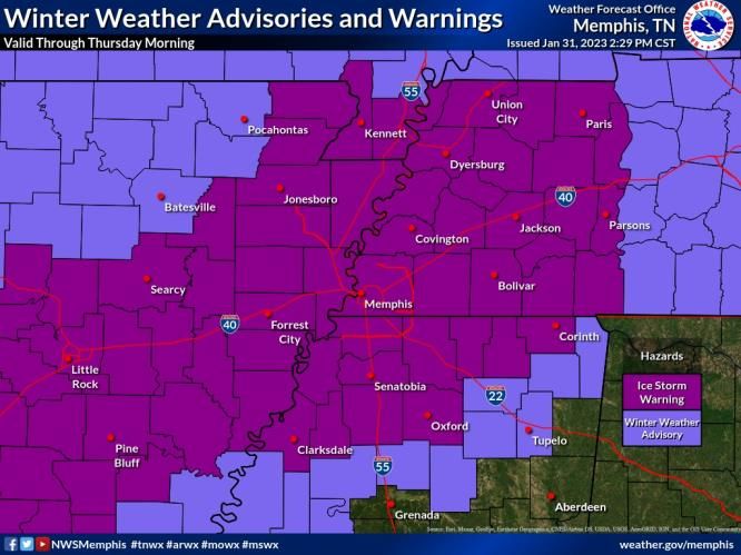
January 2023 Tennessee State Climate Summary

                                               7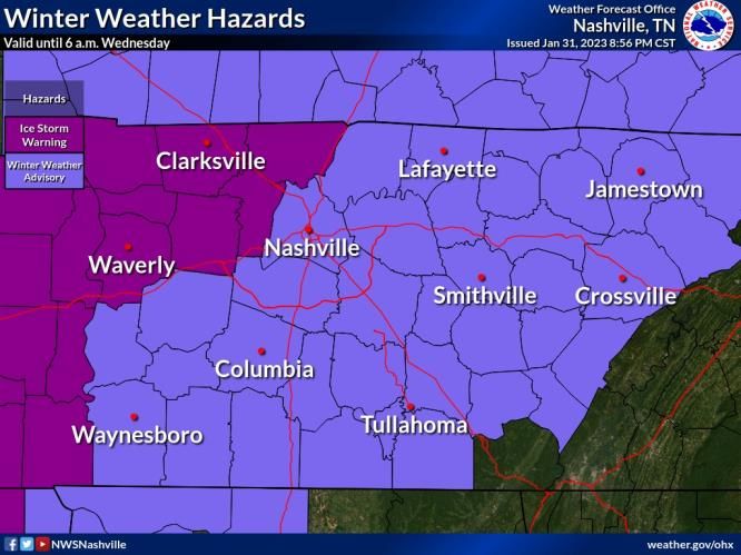
January 2023 Tennessee State Climate Summary

                                               8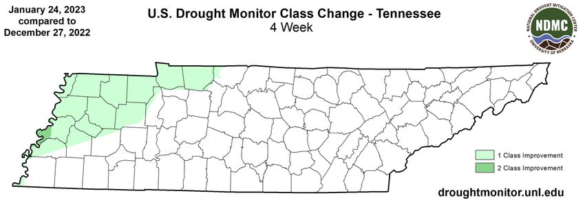
January 2023 Tennessee State Climate Summary

Drought Monitor:
In the last U.S. Drought Monitor of December 2022, there was a small area of Moderate Drought (D1) in
western Lauderdale County, and northern parts of West Tennessee, and some northwestern Middle
Tennessee counties were in Abnormally Dry Conditions (D0). Rain and snow at the end of December and
beginning of January helped to clear those areas, with the D0 removed and the area of D1 improving to
D0 in the Drought Monitor from January 3, 2023. In the January 10 release of the Drought Monitor, all of
Tennessee was clear of drought or abnormally dry conditions, and remained so for the rest of January.
This was the first time since late March 2022, that the state was clear on the U.S. Drought Monitor.

                                                                                                      9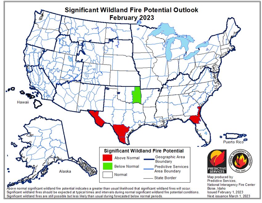
January 2023 Tennessee State Climate Summary

Soil Moisture:
Plentiful rainfall helped to increase soil moisture levels across the state this month. The NASA SPoRT Land
Information System shows that there are still some areas of below normal soil moisture in West Tennessee
and northern Middle Tennessee, where they are likely still catching up from the Fall drought. These areas
also saw the largest increases in soil moisture during January, with most of the region having a 12-16%
increase in relative soil moisture levels. The USDA Crop Progress report rated topsoil moisture across the
state as 1% short, 63% adequate, and 36% surplus; subsoil moisture was rated as 2% short, 73% adequate,
and 25% surplus.

                                                                                                        10
January 2023 Tennessee State Climate Summary
11January 2023 Tennessee State Climate Summary
Streamflow:
January streamflow was also up, with most USGS stream gauges in Tennessee reporting streamflow in
the normal range, with a few streams reporting above normal flow for the month.
Miscellaneous:
Crop Conditions from USDA: The cold snap in late December did damage to some winter wheat and
pasture grasses across the state. At the end of January, 15% of the state’s winter wheat crop and 34% of
the state’s pasture and range were reported in poor or very poor condition, 36% of hay and roughage
supplies were also reported as low or very low. Cattle were mostly in fair to good condition though. The
wet pattern for January brought new problems for pasture and fields, with many producers fighting mud
and standing water.
12January 2023 Tennessee State Climate Summary
Fire Danger: The Interagency Fire Center outlook for significant wildland fire potential shows all of
Tennessee and surrounding regions with a normal potential for fires in February.
13January 2023 Tennessee State Climate Summary
Story of the Month:
The main weather and climate stories of January 2023 were the ice storm that impacted the western half
of the state in the final days of the month and the record-setting warmth that occurred earlier in the
month.
Ice Storm: Despite the overall warmer than normal pattern across Tennessee this month, there were a
few cool spells sending temperatures into the teens or twenties for most weather stations across the state.
One of these cold spells overlapped with several rounds of precipitation moving through the region and
produced freezing rain, sleet, and some snow in the last days of January through the first of February. This
prompted ice storm warnings and winter weather advisories to be issued for West Tennessee, Middle
Tennessee, and most of the Cumberland Plateau. An ice storm warning was issued for all counties in West
Tennessee, and northwestern counties of Middle Tennessee on January 31. And reports of 0.1-0.2” of ice
accumulation were common throughout West Tennessee, and Trenton, TN in Gibson County reported
0.42” of ice accumulation from January 30-February 2.
14January 2023 Tennessee State Climate Summary
Warmth: As noted in the monthly temperature summary there were 34 daily weather records set for the
warmest high temperature and 17 daily weather records set for warmest low temperatures recorded at
weather stations across Tennessee this month. Additionally, Monterey recorded the warmest low
temperature ever observed in the month of January, with a 127-year weather history. They only got down
to a low of 63°F on Jan 3, 2023 breaking the previous record of 62 set on Jan 8, 1943.
Notable warm periods included January 1-4 and January 17-19. On January 2, Jackson, with a 73-year
weather history, set record warm high and low temperatures, and Chattanooga, with a 142-year weather
history, set a record daily high temperature, while Nashville, with a 149-year weather history, tied its
record for warmest high temperature on that date. Memphis, with a 148-year weather history also set a
record warm low temperature on January 2. On January 3 the Tri-Cities airport, with a 76-year weather
history, and Knoxville, with a 151-year weather history, set record highs for the day. On January 18,
Jackson set another daily high temperature record, and Memphis tied their record high for the date. Then
on January 19, Chattanooga and the Tri-Cities set daily high temperature records.
15January 2023 Tennessee State Climate Summary
Storm Reports:
*Storm Reports are based on filtered NOAA Storm Prediction Center data or local NWS storm reports. Future quality
control checks may change the official record of severe events, please see spc.noaa.gov for any updates.
There were three days with severe storm reports during January 2023, with a total of 4 tornadoes, 33
reports of severe wind damage, and 6 reports of severe hail (with a diameter of 1” or larger). There was
one report of an injury caused by severe storms this month.
January 2:
Tornado:
Time
Strength Location County Lat Lon Comments
(UTC)
A WEAK TORNADO TOUCHED DOWN SSW
4 SSW
8:24 EF0 HAYWOOD 35.55 -89.29 OF BROWNSVILLE... TN. EF-0 WITH 80 MPH
BROWNSVILLE
MAX WINDS. (MEG)
Wind:
Time Speed
Location County Lat Lon Comments
(UTC) (mph)
1W
7:29 60 MIDTOWN SHELBY 35.14 -90 (MEG)
MEMPHIS
3 SE REPORT OF DAMAGE TO METAL CARPORT AND
7:46 -- TIPTON 35.4 -89.69
DIXONVILLE BARN. (MEG)
1 WNW TREES DOWN ON HWY 69 SOUTH NEAR POPLAR
9:45 -- HENRY 36.26 -88.17
SPRINGVILLE GROVE ROAD. (MEG)
TSPOTTER REPORT OF DESTROYED SHED IN
CUMBERLAND CUMBERLAND FURNACE ALONG SOULES
11:30 -- DICKSON 36.27 -87.36
FURNACE CHAPEL ROAD. TIME APPROXIMATED BASED
ON RADAR. (OHX)
16January 2023 Tennessee State Climate Summary
January 3:
Wind:
Time Speed
Location County Lat Lon Comments
(UTC) (mph)
THUNDERSTORM WINDS DESTROYED
16:45 -- UNIONVILLE BEDFORD 35.62 -86.59 SHED AT A RESIDENCE NEAR
UNIONVILLE. (OHX)
TSPOTTER REPORT OF DOWNED TREES
ALONG THE RAILROAD TRACKS SOUTH
5 NNW BELL OF FOSTERVILLE NEAR BELL BUCKLE
16:59 -- RUTHERFORD 35.66 -86.4
BUCKLE ROAD AT FOSTERVILLE ROAD. A ROOF
WAS ALSO TORN OFF OF A NEARBY HAY
SHED. (OHX)
THUNDERSTORM WINDS DESTROYED
17:15 -- UNIONVILLE BEDFORD 35.62 -86.59 SHED AT A RESIDENCE NEAR
UNIONVILLE. (OHX)
THUNDERSTORM WIND DAMAGE
REPORTED ON TABOR LOOP NORTH OF
CROSSVILLE. DAMAGE INCLUDED A TREE
18:22 -- 1 N CROSSVILLE CUMBERLAND 35.97 -85.04
THAT FELL ONTO A HOUSE... A
DAMAGED CARPORT AND GARAGE...
ANOTHER UPROOTED T (OHX)
CORRECTS PREVIOUS NON-TSTM WND
GST REPORT FROM 4 SE CHATTANOOGA.
4 SE MEASURED AT THE ASOS STATION KCHA
19:32 58 HAMILTON 35.03 -85.2
CHATTANOOGA LOVELL FIELD FROM THUNDERSTORM
WINDS. IN ADDITION... PUBLIC REPORT
OF (MRX)
1 SSW SEVERAL TREES DOWN ACROSS THE
19:50 -- BRADLEY 35.16 -84.88
CLEVELAND COUNTY. (MRX)
19:55 -- 1 SE ATHENS MCMINN 35.45 -84.59 SEVERAL TREES DOWN. (MRX)
2 SE TREES AND POWERLINES DOWN ON
20:00 -- KNOX 36.06 -83.81
MALONEYVILLE ELLISTOWN RD. (MRX)
NUMEROUS TREES DOWN ACROSS THE
20:06 -- MADISONVILLE MONROE 35.52 -84.36
COUNTY. (MRX)
SEVERAL TREES DOWN ACROSS THE
20:10 -- BENTON POLK 35.17 -84.65
COUNTY. (MRX)
17January 2023 Tennessee State Climate Summary
Time Speed
Location County Lat Lon Comments
(UTC) (mph)
1 E TELLICO
20:20 -- MONROE 35.36 -84.28 SEVERAL TREES DOWN. (MRX)
PLAINS
JEFFERSON NUMEROUS SHINGLES BLOWN OFF
20:25 -- JEFFERSON 36.12 -83.49
CITY ROOF... AND TREES DOWN. (MRX)
LARGE TREE DOWN WITH PROPERTY
2 SW
20:40 -- HAWKINS 36.35 -83 DAMAGE TO STRUCTURE AND FENCE.
MCCLOUD
REPORTED BY TRAINED SPOTTER. (MRX)
COLONIAL TREES DOWN LEADING TO POWER
21:15 -- SULLIVAN 36.48 -82.51
HEIGHTS OUTAGES. (MRX)
Hail:
Time Size
Location County Lat Lon Comments
(UTC) (in)
5:50 1.00 2.2 SE HOHENWALD LEWIS 35.53 -87.53 (OHX)
January 12:
Tornado:
Time
Strength Location County Lat Lon Comments
(UTC)
*** 1 INJ *** STRAIGHT LINE WINDS WERE
OBSERVED TO HAVE CAUSED SEVERAL
1 SW DOWNED TREES AND MINOR OUTBUILDING
16:50 EF0 MEIGS 35.5 -84.8
DECATUR DAMAGE NEAR DECATUR CREEK AND
GOODFIELD ROAD. A TORNADO DEVELO
(MRX)
THE TORNADO DEVELOPED WEST OF
DANDRIDGE AND CROSSED DEEP SPRINGS
4 SSE
18:14 EF0 JEFFERSON 35.98 -83.5 ROAD. IT DISSIPATED ON THE EAST SIDE OF
PIEDMONT
DEEP SPRINGS ROAD NEAR RANCH ROAD.
(MRX)
PRELIMINARY STORM SURVEY FINDS A PATH
1E OF EF-0 DAMAGE WITH MAX WINDS OF 80
18:26 EF0 JEFFERSON 36.06 -83.26
BANEBERRY MPH. PATH LENGTH OF 1 MILE AND WIDTH
OF 100 YARDS. (MRX)
18January 2023 Tennessee State Climate Summary
Wind:
Time Speed
Location County Lat Lon Comments
(UTC) (mph)
CORRECTS PREVIOUS TSTM WND DMG
5 NE GRIFFITH REPORT FROM 5 NE GRIFFITH CREEK.
16:01 -- SEQUATCHIE 35.34 -85.49
CREEK SEVERAL REPORTS OF TREES DOWN
COUNTY WIDE. (MRX)
4W
17:09 -- BRADLEY 35.18 -84.93 TREES DOWN. (MRX)
CLEVELAND
CORRECTS PREVIOUS NON-TSTM WND
GST REPORT FROM 2 N ALCOA. ASOS
17:45 69 2 N ALCOA BLOUNT 35.82 -83.98
STATION KTYS KNOXVILLE MCGHEE
TYSON. (MRX)
1 E LAKE TREE WAS BLOWN DOWN ONTO POWER
17:54 -- KNOX 35.93 -83.86
FOREST LINES AND IS BLOCKING THE ROAD. (MRX)
WIDESPREAD TREES DOWN ACROSS THE
17:55 -- MAYNARDVILLE UNION 36.24 -83.8
COUNTY. (MRX)
1 ENE REPORT OF TREES DOWN ACROSS
18:03 -- BLOUNT 35.68 -83.74
TOWNSEND BLOUNT COUNTY. (MRX)
TREE DOWN BLOCKING ROBERTS ROAD AT
18:10 -- 4 E KODAK SEVIER 35.96 -83.56
SUNRISE BLVD. (MRX)
3 SW SHINGLES MISSING FROM ROOF AND ONE
18:17 60 JEFFERSON 36.01 -83.43
DANDRIDGE LARGE TREE BLOWN DOWN. (MRX)
18:20 70 DANDRIDGE JEFFERSON 36.02 -83.43 NEAR HIGHWAY 92. (MRX)
5 NE GRIFFITH SEVERAL REPORTS OF TREES DOWN
18:33 -- SEQUATCHIE 35.34 -85.49
CREEK COUNTY WIDE. (MRX)
SHINGLES WERE BLOWN OFF HOUSES
18:54 -- TUSCULUM GREENE 36.17 -82.76 AND TREES KNOCKED DOWN IN THE
TUSCULUM AREA. (MRX)
CORRECTS PREVIOUS NON-TSTM WND
TRI-CITY GST REPORT FROM TRI-CITY AIRPORT.
19:19 62 SULLIVAN 36.48 -82.4
AIRPORT ASOS STATION KTRI TRI-CITIES AIRPORT.
(MRX)
CORRECTS PREVIOUS NON-TSTM WND
DMG REPORT FROM 5 S SMYRNA.
19:40 -- 5 S SMYRNA RUTHERFORD 35.91 -86.51 TSPOTTER REPORT AND PHOTO SHOWED
A LARGE TREE LIMB FELL AND CRUSHED A
SHED ON BLACKMAN RD. (OHX)
CORRECTS PREVIOUS NON-TSTM WND
DMG REPORT FROM 5 N IRON CITY. TREE
21:45 -- 5 N IRON CITY LAWRENCE 35.09 -87.58
DOWN BLOCKING ROAD AT 3320
WAYLAND SPRINGS RD. (OHX)
STRAIGHT-LINE WINDS CAUSED DAMAGE
NEAR MOORESVILLE. DAMAGE INCLUDED
23:09 -- 7 NE LYNNVILLE MARSHALL 35.44 -86.91 A DESTROYED STORAGE SHED... DOWNED
TREES... METAL ROOFING TORN OFF A
BARN AND SILO... AND SIDING AND (OHX)
19January 2023 Tennessee State Climate Summary
Hail:
Time Size
Location County Lat Lon Comments
(UTC) (in)
1 NNE REPORT FROM MPING: QUARTER (1.00 IN.).
19:18 1.00 WILLIAMSON 36.01 -86.78
BRENTWOOD (OHX)
4 SE OAK QUARTER SIZE HAIL IN NIPPERS CORNER.
19:19 1.00 DAVIDSON 36.04 -86.74
HILL TIME ESTIMATED BY RADAR. (OHX)
HAIL SLIGHTLY LARGER THAN A QUARTER
3E REPORTED IN THE AREA OF SWEETWATER
19:21 1.00 WILLIAMSON 36 -86.73
BRENTWOOD DRIVE AND LITTLE STONE DRIVE IN
BRENTWOOD. (OHX)
QUARTER SIZE HAIL FALLING AT THE CORNER
2 NW
19:22 1.00 DAVIDSON 36.09 -86.7 OF HARDING PIKE AND I-24. TIME ESTIMATED
ANTIOCH
BY RADAR. (OHX)
QUARTER-SIZED HAIL REPORTED NORTH OF
1N
19:53 1.00 RUTHERFORD 35.98 -86.38 WALTERHILL. TIME ESTIMATED VIA RADAR.
WALTERHILL
(OHX)
20January 2023 Tennessee State Climate Summary
CPC Outlooks for the Next Month:
The NOAA Climate Prediction Center outlook for February shows that all of Tennessee is leaning towards
a warmer than normal month, with 40-50% likelihood. Tennessee is also leaning towards a wetter than
normal February, with the western half of the state having a 50-60% chance of a wetter than normal
February while the eastern half has a 40-50% likelihood of a wetter than normal February.
21You can also read