Isles of Scilly - Project Report Kevin Camidge With contributions by - CISMAS
←
→
Page content transcription
If your browser does not render page correctly, please read the page content below
Isles of Scilly
De s ig na t ed Wr e ck s I nt er pr et at io n

      Project Report
               Kevin Camidge
               With contributions by

             Tom Goskar & Mark James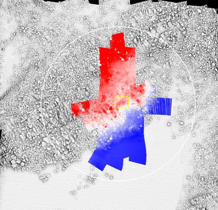
Project Name            Isles of Scilly Designated Wrecks Interpretation
                        Project Report
HE Reference            7561

Author                  Kevin Camidge                     Tom Goskar
                        01736 365429                      Mark James
                        darkwright@btinternet.com
Origination date        27·XI·2017

Date of last revision   06.XII.2017

Version                 1.0

Status                  DRAFT

2   Isles of Scilly Designated Wrecks Interpretation                       Project Report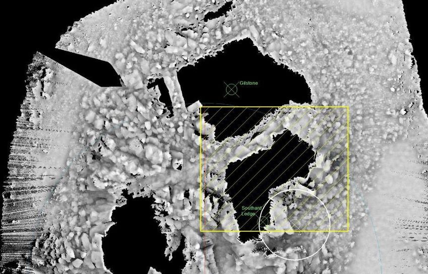
Contents
Summary ................................................................................................................................................. 4
Background.............................................................................................................................................. 4
  HMS Association .................................................................................................................................. 4
  Bartholomew Ledges ........................................................................................................................... 6
  HMS Colossus ...................................................................................................................................... 6
  Tearing Ledge ...................................................................................................................................... 7
  The Wheel Wreck ................................................................................................................................ 7
Multi Beam Echo Sounder Survey ........................................................................................................... 8
  Association .......................................................................................................................................... 9
  Tearing Ledge .................................................................................................................................... 10
  Bartholomew Ledges ......................................................................................................................... 12
  The Wheel Wreck .............................................................................................................................. 13
  Colossus ............................................................................................................................................. 14
  Multibeam Methodology by Mark James ......................................................................................... 17
     Limitations with Multibeam Sonar of Wreck Material on Archaeological Sites ........................... 18
Photo and Video Survey ........................................................................................................................ 21
  Association ........................................................................................................................................ 21
  Tearing Ledge .................................................................................................................................... 22
  Bartholomew Ledges ......................................................................................................................... 23
  The Wheel Wreck .............................................................................................................................. 23
The Virtual Dive Trails............................................................................................................................ 25
  Methodology for the 3D Site Plans by Tom Goskar .......................................................................... 25
Measuring Impact ................................................................................................................................. 27
  Why measure impact?....................................................................................................................... 27
  Economic ........................................................................................................................................... 27
  Environmental ................................................................................................................................... 27
  Knowledge ......................................................................................................................................... 27
  Culture ............................................................................................................................................... 27
  Practice and Innovation..................................................................................................................... 28
  Policy ................................................................................................................................................. 28
Volunteer Participation ......................................................................................................................... 29
  Volunteer Record .............................................................................................................................. 29
Bibliography........................................................................................................................................... 30

Cover Photograph: Sunset over the Island of Samson

Project Report                                                     Isles of Scilly Designated Wrecks Interpretation                              3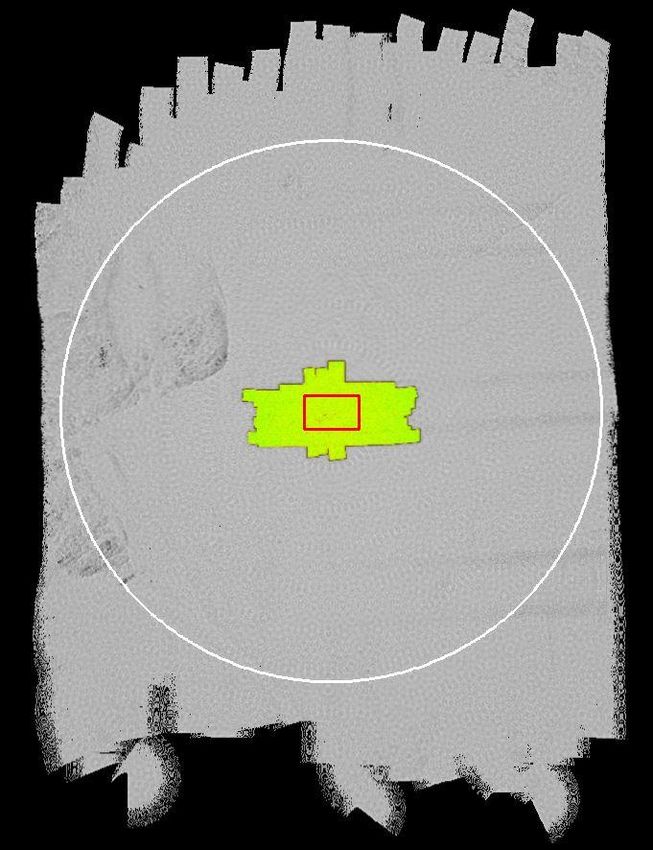
Summary
This project concerns the five designated wreck sites situated in the Isles of Scilly: Tearing Ledge,
HMS Association, Bartholomew Ledges, HMS Colossus and the Wheel Wreck. The first phase of the
project collected high resolution multi-beam data for each of the five sites. The second phase
entailed production of photographs and video from four of the sites (not including HMS Colossus).
The final phase was the creation of web-based virtual site tours for the Tearing Ledge, HMS
Association, Bartholomew Ledges and the Wheel Wreck, and the enhancement and integration of
the existing HMS Colossus virtual dive trail. This report details the methodologies employed to
achieve these results. Finally, a measuring impact report and volunteer reports have been included.

Background
The Isles of Scilly is an archipelago situated some 45km to the west of the Cornish Peninsula. There
are currently five designated wreck sites situated within the Scillies – a brief summary of each site is
presented below.

HMS Association
Location                  The Gilstone Ledges, Western Rocks
Designated                2014 (49⁰ 51.73’N - 006⁰ 24.50’W - 50m radius)
Wrecked                   1707
Built                     1696
Type of vessel            90-gun second-rate English warship
Depth                     5-40m – this site is very three-dimensional
Description               The site is located in deep rock gullies with large boulders. There are over 60 iron
                          guns, three anchors and a number of iron concretions including iron shot. Some
                          guns and at least one anchor have been removed from the site. Numerous artefacts
                          have been recovered from the site including a considerable quantity of coins.
Public Access             Public access to the site is achieved by licence under the Protection of Wrecks Act.
                          This licensing is currently administered by Historic England. The three dive charter
                          boats operating in Scilly have annual licences to visit the site. There is no formal
                          dive trail or interpretive material currently available to visitors.
Management Plan           No
HE list number            1419276
NHLE link                 https://www.historicengland.org.uk/listing/the-list/list-entry/1419276
                          accessed 17.XII.2016

Survey Notes              The current designated area does not cover all the known remains (it is situated too
                          far to the south and is too small). A circle centred at 49⁰ 51.785’N 06⁰ 24.523’W of
                          150m radius should encompass the known remains.

       4   Isles of Scilly Designated Wrecks Interpretation                                  Project Report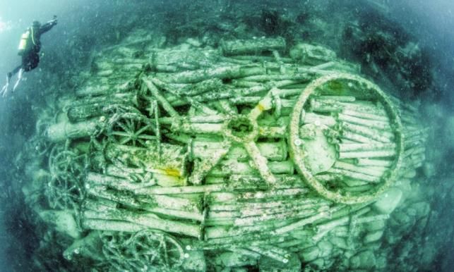
Fig 1
      Right: The location of the Isles of Scilly 45 km to the
      west of Land’s End

      Below: The Isles of Scilly showing the location of the
      five designated wreck sites (blue circles): Tearing
      Ledge, HMS Association, Bartholomew Ledges, HMS
      Colossus and the Wheel Wreck.

                       KEY

               Protected wreck site

Project Report                                        Isles of Scilly Designated Wrecks Interpretation   5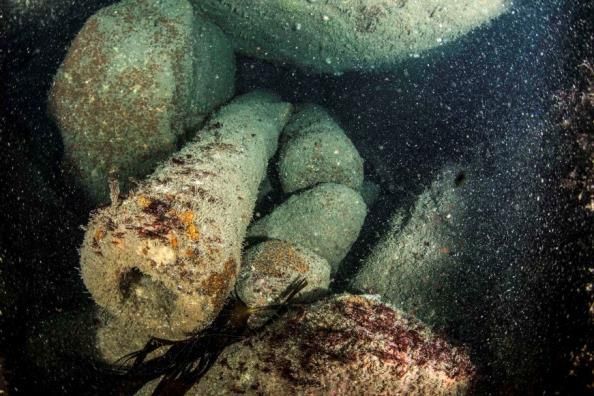
Bartholomew Ledges
Location                 Bartholomew Ledges, St Mary’s Sound
Designated               1980 (49⁰ 54.364’N - 006⁰ 19.889’W - 150m radius)
                                 th
Wrecked                  Late 16 century
Built                    Unknown
Type of vessel           Unknown, thought to be an armed merchant vessel.
Depth                    0-15m (mostly 10-15m)
Public Access            Public access to the site is achieved by licence under the Protection of Wrecks Act.
                         This licensing is currently administered by Historic England. The three dive charter
                         boats operating in Scilly have annual licences to visit the site. The site has not been
                         visited since 2010, mainly due to the very thick kelp growth covering the site. There
                         is no formal dive trail or interpretive material currently available to visitors.
Management Plan          Yes
HE list number           1000066
NHLE link                https://www.historicengland.org.uk/listing/the-list/list-entry/1000066
                         accessed 17.XII.2016
Survey Notes             Surveying an 80m radius around the designation should cover the known remains.

HMS Colossus
Location                 South of Samson in St Mary’s Roads
Designated               2001 (49⁰ 55.471’N - 006⁰ 20.505’W - 300m radius)
Wrecked                  1798
Built                    1787
Type of vessel           72-gun third-rate English warship
Depth                    12-14m
Description              Only the stern of the wreck is currently designated - this is located on a flat sandy
                         bottom. Remains include a large section of the hull, nine iron cannon, numerous
                         muskets and iron concretions. Many small artefacts remain on the seabed.
Public Access            Public access to the site is achieved by licence under the Protection of Wrecks Act.
                         This licensing is currently administered by Historic England. The three dive charter
                         boats operating in Scilly have annual licences to visit the site. There is a formal dive
                         trail with interpretive material currently available to visitors. There is also an
                         interactive virtual dive trail, allowing access for non-divers (which had over 500
                         visitors in its first month).
Management Plan          Yes
HE list number           1000078
NHLE link                https://www.historicengland.org.uk/listing/the-list/list-entry/1000063
                         accessed 17.XII.2016
Survey Notes             A 30m radius around the designation covers the stern wreckage currently exposed
                         on the surface. However, there is wreckage throughout much of the designated
                         area.

       6   Isles of Scilly Designated Wrecks Interpretation                                     Project Report
Tearing Ledge
Location          Tearing Ledge, near Bishop Rock lighthouse
Designated        1975 (49⁰ 52.200’N - 006⁰ 26.483’W - 200m radius)
Wrecked           1707
Built             1679 (HMS Eagle)
Type of vessel    Probably HMS Eagle, a 70-gun third-rate English warship
Depth             0-45m (mostly about 35m)
Description       The Tearing Ledge is a rock pinnacle which breaks surface at low tide. Underwater, the Ledge
                  is surrounded by very large rock gullies with some patches of sandy sediment, and in one of
                  these gullies - which slopes from 20m down to over 40m in depth - the majority of the wreck
                  remains lie. What survive on the seabed now are two large iron anchors, over 60 iron guns
                  and a number of iron objects, including iron shot. To date, no evidence of ship’s structure has
                  been located. The site is largely free from kelp but is subject to very strong tides and swell-
                  generated surge.
Public Access     Public access to the site is achieved by licence under the Protection of Wrecks Act. This
                  licensing is currently administered by Historic England. The three dive charter boats
                  operating in Scilly have annual licences to visit the site. There is no formal dive trail or
                  interpretive material currently available to visitors
Management Plan   Yes
HE list number    1000063
NHLE link         https://www.historicengland.org.uk/listing/the-list/list-entry/1000063
                  accessed 17.XII.2016
Survey Notes      A radius of 90m around the designation covers the known wreckage.

The Wheel Wreck
Location          Near Little Ganinick in Crow Sound
Designated        2007 (49⁰ 56.4449’N - 006⁰ 16.3809’W - 75m radius)
                     th
Wrecked           19 century
Built             Unknown
Type of vessel    Unknown
Depth             16m
Description       The site consists of a cargo mound (approx. 10m x 8m x c.1m high) and a possibly associated
                  anchor. The cargo mound contains iron machinery including geared wheels, pump parts
                  (rising mains and clack valves) and boiler tubes. No vessel remains have been reported. The
                  cargo may represent a consignment from a Cornish foundry, in which case this site has links
                  to the Cornish Mining World Heritage Site. The cargo is likely to date from 1850 onwards.
Public Access     Public access to the site is achieved by licence under the Protection of Wrecks Act. This
                  licensing is currently administered by Historic England. The three dive charter boats
                  operating in Scilly have not applied for licences to visit this site. There is no formal dive trail
                  or interpretive material currently available to visitors.
Management Plan   No
HE list number    1000086
NHLE link         https://www.historicengland.org.uk/listing/the-list/list-entry/1000086
                  accessed 17.XII.2016
Survey Notes      A radius of 25m around the designation position covers the main area of known wreckage.
                  However a large iron anchor is reported ’80m SW of the site’ at position
                  49⁰ 56.417’N, 06⁰ 16.408’W.

Project Report                            Isles of Scilly Designated Wrecks Interpretation                  7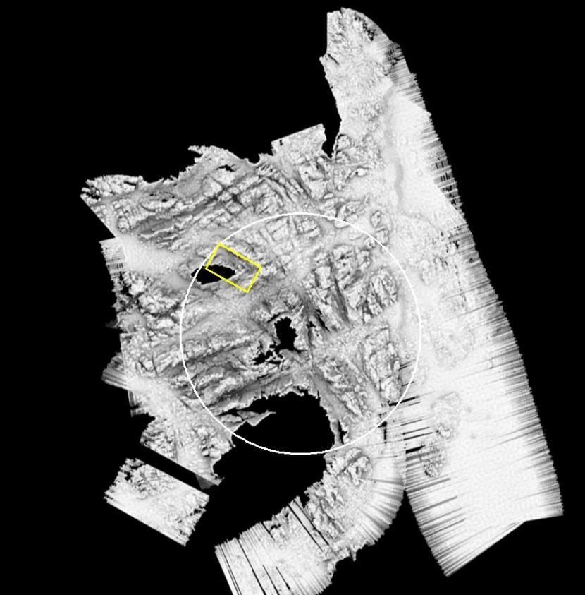
Multi Beam Echo Sounder Survey
The multi beam echo sounder survey (MBES) was undertaken from the Inshore Fisheries and
Conservation Authority (IFCA) survey vessel Tiger Lilly. The survey took place 22nd-24th April 2017.
The weather conditions were perfect, with a flat calm sea even out on the Western Rocks where
there is nearly always a swell over the sites of Tearing Ledge and the Association. The Association and
Tearing Ledge sites were surveyed on the 21st April, the Wheel Wreck and Bartholomew Ledges on
the 22nd and Colossus on the 23rd April. Calibration was undertaken on the 24th of April before
returning to the mainland to avoid stormy conditions which were forecast for later that day.

  Fig 2
  The IFCA survey vessel Tiger Lilly

       MBES Survey Team
Mark James          MSDS
Mark Gray           Swathe
Mat King            Services
Colin Trundle
                    IFCA
Don Mathew
Kevin Camidge
                    CISMAS
Sharon Austin

        8   Isles of Scilly Designated Wrecks Interpretation                           Project Report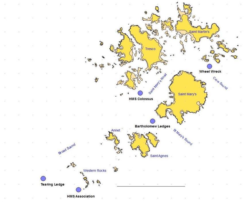
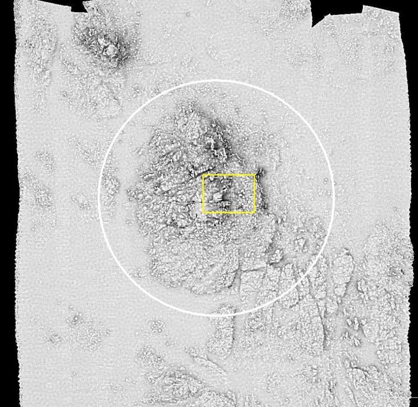
HMS Association
Of all the designated wreck sites in Scilly this was the most difficult to survey. A number of rocks
which break surface at low tide make navigating a boat in this area either interesting or terrifying
depending on your outlook and disposition. Fig 3 below shows the areas where it was not possible to
survey; unfortunately, in this case a significant proportion of the known site remains are within areas
not surveyed. However, the MBES has provided data allowing us to map the seabed around the site.
In the 3D models the missing areas were reconstructed from photographs, video and sketch plans.

There are over 60 iron guns and two anchors located in deep rock gullies with large boulders. In
many cases, these guns are located beneath the boulders. It is perhaps not surprising, therefore, that
none of the guns or anchors are discernible on the MBES survey.

   N

 Fig 3
 The MBES survey is shown plotted above in grey. The black areas are regions which were not surveyed – the ‘black
 holes’ in the survey represent areas where rocks prevented the boat surveying. The area of known remains of the
 Association (iron guns and anchors) is represented by the yellow cross-hatched rectangle. The white circle (to the right
 of Southard Ledge) denotes the current designated area.

This survey was undertaken at 450 kHz.

Project Report                                       Isles of Scilly Designated Wrecks Interpretation               9
Tearing Ledge
The Tearing ledge is a rock which breaks surface – for this reason it was not possible to collect multi-
beam data in its immediate vicinity. However, as can be seen in fig 4, nearly all the known remains
were included in the MBES survey area. The missing area around the Tearing Ledge was recreated in
the 3D model from charts, photographs and the excellent site plan produced by Rex Cowan’s team in
1971-1976.

Unfortunately, it was not possible to discern any of the iron guns or anchors in the multi-beam data
of this site. The most likely cause for this is the depth of the site – most of the remains are in more
than 30m of water.

        N

   Fig 4
   The MBES survey is plotted above in grey. The black areas are regions which were not surveyed – the ‘black holes’ in the
   surveyed area represent areas where rocks prevented the boat surveying. The area of known remains on the site (iron
   guns and anchors) is represented by the yellow rectangle. The white circle denotes the current designated area.

     10    Isles of Scilly Designated Wrecks Interpretation                                              Project Report
Fig 5 A detail from the MBES data shown with the site plan superimposed. The ‘black hole’ in the MBES plan is where the Tearing Ledge prevented collection of data. The site plan was made by Rex Cowan and his team between 1971 and 1976. Note that this plan also contains measurements of all the guns (made by Peter McBride). The correlation between the seabed topography depicted on the MBES survey and the superimposed site plan is remarkable. Take note of the north pointer (in the top right corner) – this illustration is NOT ‘north-up’. The 1976 site plan is reproduced by kind permission of Rex Cowan and Peter McBride. The MBES survey of Tearing Ledge was undertaken at 450 kHz. Project Report Isles of Scilly Designated Wrecks Interpretation 11
Bartholomew Ledges
The whole of the designated area around the Bartholomew Ledges was surveyed by multi-beam at
450 kHz. This has resulted in a good 3D terrain model of the Ledges, which was utilised for the virtual
site tour. The site is covered in dense kelp which makes locating the guns and anchors which are on
the site difficult. The kelp may also be resposible for the slightly hairy appearance of the 3D model.
None of the guns and anchors present on the site were discernable in the multi-beam data.

                                   North Bartholomew Rock

      N

                                                               Bartholomew Ledges

 Fig 6
 The MBES survey shown plotted above in grey. The black areas are regions which were not surveyed. The area of known
 remains (iron guns and anchors) is represented by the yellow rectangle. The white circle denotes the current designated
 area.

     12    Isles of Scilly Designated Wrecks Interpretation                                             Project Report
The Wheel Wreck
N
Fig 7
The MBES 450 kHz survey is shown plotted above in grey with the smaller area surveyed at 700 kHz
superimposed in red (shallower water) and blue (deeper water). The area of the cargo mound is represented
by the yellow rectangle – the large iron wheel on the cargo mound can be seen in the lower left corner of the
rectangle. The white circle denotes the current designated area. The position of the Trotman anchor is
indicated by the black arrow.
The wheel wreck MBES survey was undertaken at 450 kHz over the whole of the designated area,
with a smaller area - centred on the cargo mound - being additionally surveyed at 700 kHz. The larger
items of the cargo mound (the large wheel rim and the wheel spokes) were discernable on the MBES
surveys. The Trotman anchor to the south-west of the cargo mound was not visible on the MBES
survey, but this is located between two large rocks which are probably masking the anchor.
Project Report Isles of Scilly Designated Wrecks Interpretation 13HMS Colossus
N
Fig 8
The extent of the MBES 450 kHz survey shown plotted above in grey with the smaller area surveyed at
700 kHz superimposed in yellow. The area of exposed timber at the stern is outlined by the red
rectangle. The white circle denotes the designated area at the time the survey was undertaken (it has
since been enlarged).
14 Isles of Scilly Designated Wrecks Interpretation Project ReportThe whole of the designated area was surveyed at 450 kHz. Note that after the MBES survey was
undertaken the designated area was modified from a circle to a rectangle, which now takes in the
area of the ‘bow site’ to the south west. Unfortunately, bad weather prevented the survey of the
additional area encompassed by the new designation. A number of previously unknown ‘areas of
interest’ were noticed on the MBES survey and four of these were chosen for rapid assessment by
the dive team – these are shown in the table below.
Ref Multibeam target Observed Dimensions Northing Easting From G1 Record
MB1 Cluster of material Cluster of angular Reef about 5535882 260221 302m Video
on the edge of a rocks – no wreckage 8m 12⁰
reef – looks like
wreckage
MB2 Small circular Dome shaped 1.5m 5535738 260280 195m Sketch
anomaly adjacent circular iron feature 39⁰ Photo
th
to 2 mag targets with rivets. 19-20 Video
century
MB3 Angular anomaly Small angular rocky Rock 2.5m 5535403 259957 271m Video
on sandy seabed reef on a flat sand 228⁰
near G9 seabed.
MB4 Linear target Iron angle crown 1.67m fluke 5535518 260315 172m Sketch
adjacent to a mag anchor. The ring end to fluke 113⁰ Photo
target of the shank appears 2.87m shank Video
to be broken
MB1
Fig 9
A detail from the 450 mHz MBES survey of
Colossus showing an area of rocky seabed to
the north of the main site, with possible
wreckage showing on the western edge.
The divers found only a shallow rocky reef surrounded by a flat sandy seabed – there were no visible
artefacts.
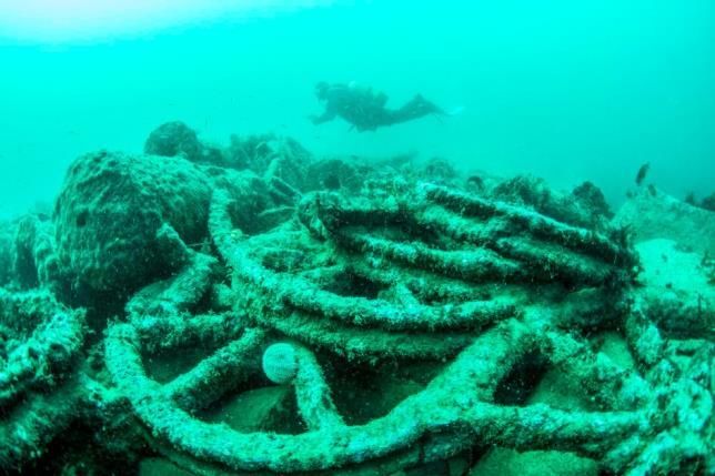
Project Report Isles of Scilly Designated Wrecks Interpretation 15MB2
Fig 10 Fig 11
A detail from the 450 mHz MBES survey of Colossus What was found on the seabed: a slightly domed,
showing a small circular target. This target also showed circular riveted iron object (not unlike a steam powered
on a magnetometer survey undertaken in 2004. flying saucer in appearance).
This target proved to be a circular, slightly domed iron object with other iron parts buried in the
sediment around it. Several rows of iron rivets were visible on the disk. Probably debris from an iron
wreck.
MB3
Fig 10
A detail from the 450 mHz MBES survey of
Colossus showing a small jagged target in
the vicinity of gun 9.
This target was selected because of its proximity to gun 9, but proved - as suspected - to be a small
piece of upstanding reef on a flat sandy seabed. Gun 9 was found to be still in place.
16 Isles of Scilly Designated Wrecks Interpretation Project ReportMB4 Fig 11 Above: A detail from the 450 mHz MBES survey of Colossus showing a small linear target to the south east of the main wreck. Right: A small angle crown anchor found when this target was investigated. On investigation this target was found to be a wrought-iron angle crown anchor (shank 2.87m long, fluke to fluke 1.67m). Multibeam Methodology by Mark James The Multibeam data were collected using an R2Sonic 2022 Multibeam Echo Sounder mobilised onto the survey support vessel Tiger Lilly. The 2022 offers an excellent combination of resolution, ease of use and size and weight making it the idea system for short, high resolution surveys undertaken on vessels of opportunity. At 400 kHz the 2022 has a beam width of 1.0° x 1.0° reducing to 0.6° x 0.6° when in 700 kHz UHR mode. The 2022 has a real time user selectable swath sector of 10° to 160° and a range resolution of up to 1.25cm. These features ensure high resolution, high density data collection - the parameters of which can be adjusted in real time to ensure optimum ensonification of the seabed and any features of potential archaeological interest. Positioning and motion for the MBES were controlled using an Applanix POS MV WaveMaster with real time RTK corrections. The Applanix system with RTK corrections can produce positional accuracy of >0.1m, roll and pitch to 0.02°, heading to 0.03° and heave to 2cm or 2%. The MBES was mobilised onto Tiger Lilly using a rigid metal frame incorporating the Applanix POS MV WaveMaster Inertial Measurement Unit (IMU) and the antennas. By mounting the MBES, the IMU and the antennas on the same rigid frame, common errors associated with vessels of opportunity Project Report Isles of Scilly Designated Wrecks Interpretation 17
such as offset errors and hull flex were reduced to a minimum. Prior to data collection a patch test
was undertaken to determine any offsets between the MBES, the IMU and heading sensor. Offset
corrections were then applied to the dataset to ensure minimal errors in the positioning and overlap
of the data. MBES data was collected by running predetermined lines based on the depth of water to
achieve a data overlap of 50%. The deeper the water the wider the coverage at a fixed swath sector,
however beam footprint will increase and data density will decrease. The data recorded was
displayed in real time; as such online QC took place and lines were re-run or data gaps filled in where
required.

Sound velocity was recorded continuously at the MBES head with a Valeport Mini Sound Velocity
Sensor (SVS) and at intervals through the water column with a Valeport Sound Velocity Profiler (SVP).
Sound velocity measurements are required, and applied to the MBES data, in order to correct errors
that may be created due to variations in the speed of sound through the water column. All line
planning and MBES data collection was undertaken in HyPack HySweep. Following data collection,
patch test and tide corrections were applied within HyPack HySweep and the data exported as
individual lines in XYZ format. The lines of data were then cleaned in various programs - including
HySweep, Fledermaus and Cloud Compare - to remove noise, data artefact and unwanted features
such as fish or kelp. Once the data was cleaned, the lines were imported into software - including
Fledermaus and Cloud Compare - where the data was visualised and effects such as shading applied
to help highlight potential anthropogenic features.

Limitations with Multibeam Sonar of Wreck Material on Archaeological Sites

Multibeam sonar (MBES) is primarily, and widely, used for the bathymetric mapping of the seabed,
typically for the production of navigational charts. MBES is now also commonly used for the mapping
of shipwrecks in an archaeological context as has been demonstrated by the works undertaken on
the Isles of Scilly. The environments and the wrecks varied largely from Colossus - a wreck site
consisting of wooden structure and scattered guns, lying on a sandy seabed in c.10m of water to the
Wheel Wreck - a contained wreck mound of industrial fittings lying on a rocky seabed in c.18m of
water, to the Tearing Ledge site - consisting of scattered iron guns in rocky gullies in c.35m of water.
The results of the MBES survey varied across the sites; it is important to note that this doesn’t refer
to the quality or the accuracy of the data but the components of the sites that were able to be
ensonified and limitations with the use of MBES in these environments. As discussed in the
methodology, depth plays a big role in data density and coverage, but other factors including seabed
composition, access and marine growth such as kelp can all have a large impact on the survey and
the ensonification of features.

Depth
MBES data is collected using multiple ‘beams’ arranged in a fan-like array, or swath, in a
port/starboard orientation. The width of the swath can be changed by altering the angle of the
swatch sector at the head. This has the effect of compressing or widening the distance between the
individual beams, although all originate at a single point. With the beams originating at a single point
and spreading out as they travel towards the seabed, the distance between each beam at the seabed
will increase the deeper the water in which the survey is being undertaken. The spreading out of the

     18   Isles of Scilly Designated Wrecks Interpretation                              Project Report
beams in deeper water will decrease the density of the data at a set swath sector, requiring more runs to achieve the same data density. Another consideration is the achievable resolution in deeper water with regard to the footprint of each individual beam. Put simply, the smaller the beam footprint the higher the resolution. Each beam is conical in its formation; thus - as with the spread of beams - the deeper the water, the larger the beam footprint. Seabed Composition As can be noted on the Colossus site, where the seabed is largely sandy and flat, features such as timber and cannon are easily identifiable due to their prominence from the surrounding seabed. On sites such as the Association, Bartholomew Ledges and Tearing Ledge it is notable that features such as guns and anchors are not identifiable in the dataset. The dataset clearly shows a very rocky seabed and review of the video footage shot during the 2017 fieldwork season shows the guns in the majority of instances nestled within the rocks. Two factors to do with seabed composition effect the identification of features: firstly, MBES is a bathymetric mapping tool, thus it records height data at a given point; secondly the rocks on the seabed vary in size and shape with many linear elements. Therefore, the two main tools used for the identification of archaeological features, the height above the surrounding seabed and presence of linear or regular anomalies, become harder to use especially when looking for smaller features. It should be noted that the dataset from the Wheel Wreck shows a high level of detail despite being on a rocky seabed. The wreck mound is elevated above the surrounding seabed, so not ‘camouflaged’ in the dataset and the features of the wreck are dissimilar to the surrounding seabed. Marine Growth Marine growth and in particular kelp can have a detrimental effect on the quality of MBES data for a number of reasons. Dense kelp will stop a high proportion of the beams reaching the seabed which has a few impacts: the data density of the actual seabed will be much reduced making the identification of features either harder or impossible, the kelp may completely obscure some features, and the presence of kelp in a dataset will manifest itself as a lot of ‘noise’ in the area above the seabed due to the kelp being identified as the seabed by the MBES. The cleaning of this data is not only time consuming but can also result in the inadvertent removal of ‘real’ data, although every care is taken to ensure that this doesn’t happen. Site Access and Topography With the MBES being collected by a fan running port/starboard to the vessel the best quality data with the most consistent coverage will always be collected when running straight, steady lines. Three of the sites where located on, or near, unnavigable areas with protruding rocks and very shallow areas, meaning that straight steady lines were not possible. Different approaches had to be used - including nudging in and out of hazardous areas which creates bunching and spreading out of data, due to changes in speed and circling around hazards which leads to bunching of data on the inside of the track and spreading out of the data on the outside of the track. These areas also had rapidly sloping seabeds, making it harder to maintain consistent coverage across the width of the swath. The Project Report Isles of Scilly Designated Wrecks Interpretation 19
constantly changing environment meant that the other parameters needed to be constantly adjusted
to ensure good quality data.

Conclusion
Whilst the data collected was of good quality and provided a very good topographic map across all
sites, a number of factors affected the ability for some of the archaeological features to be effectively
ensonified. Whilst individually these factors may have been able to be mitigated against, the
combination of depth, marine growth, accessibility and seabed composition and topography meant
that on sites such as Tearing Ledge features such as the guns were not able to be identified with any
certainty.

     20   Isles of Scilly Designated Wrecks Interpretation                               Project Report
Photo and Video Survey
The photo and video survey was undertaken by the CISMAS dive team 13th – 18th August 2017. The
diving took place from the dive charter vessel Moonshadow, which is based in the Isles of Scilly. On
each site two divers collected video using GoPro cameras in underwater housings. At the same time,
two other divers took digital photographs using conventional digital cameras in underwater housings.
The digital photo files were all converted to the DXF format to ensure that they were all in the same
format – JPEG or TIFF files can be made from these if required.
Photo & Video Survey Team
Matt Andrews
Sharon Austin
Kevin Camidge
CISMAS
Jeff Dicker
Andrew Grant
Brendon Rowe
Four different sites were photographed: Association, Tearing Ledge (Eagle), the Bartholomew Ledges
and the Wheel Wreck. The Association and Tearing Ledge were both dived on the first day (one dive
on each) – sea conditions subsequently precluded any further diving on these two sites.
Association
This site was photographed first, as conditions on the morning of the first day were suitable for
diving and this site is notoriously difficult to access except in very benign weather. The divers entered
the site at the eastern end of a deep gulley with large boulders and eroded iron guns. The shot-line
was at position 255005E, 5528945N UTM. We believe this is the gulley labelled as ‘cannon gulley’ on
Terry Hiron’s plan of the site. During the dive, this gulley was explored to the west of the entry point
and numerous iron guns and occasional iron concretions were encountered. As the visibility was poor
and light levels very low, conditions were not ideal for photography.
Fig 12
One of the iron guns located within
‘cannon gulley’ on the wreck of the
Association
Project Report Isles of Scilly Designated Wrecks Interpretation 21Tearing Ledge
This site was photographed during the second dive on the first day (the first dive was on the
Association). This required a wait of over six hours for slack water. The dive commenced on the
northern side of the Tearing Ledge rock at approximately 252576E, 5529979N UTM. About one-third
of the site was covered by the dive team, comprising the western end of the site. This included the
two anchors and about 30 of the iron guns. Visibility was good on the site, which resulted in a
satisfactory set of photographs and video. Only one dive on this site was possible, due to the sea
conditions prevailing after the first day.
Fig 13
One of the large iron bower anchors on the
Tearing Ledge site.
22 Isles of Scilly Designated Wrecks Interpretation Project ReportBartholomew Ledges The team dived on this site on 14th August. Two separate locations on the site were searched, the locations chosen from the site plan produced in 2005 (Wessex Archaeology, 2005), but nothing could be found on the site at these locations. The kelp on the seabed was extremely dense which made finding small, heavily-concreted objects problematic. A second dive was undertaken on 15th August, on the south side of the beacon which marks the Bartholomew Ledges. Two iron guns were located (those labelled as WA7 and WA25 on the site plan). Despite further searching, these were the only artefacts located by the dive team on this site. In 2005 the kelp over the site had been cut down by the licensee and his team (CISMAS divers actually helped with this task). With the kelp in place, it is extremely difficult to even find the small guns and anchors which comprise the ‘visible’ remains of this site. Fig 14 Above: One of the iron guns on the seabed, almost completely obscured by kelp. Right: A diver’s eye view of the thick kelp cover on this site. The Wheel Wreck A total of five separate dives were undertaken on the Wheel Wreck. Video and photographs were taken on the main cargo mound, the isolated wreckage (broken iron cylinder) to the north-west of the cargo mound and on the Trotman Anchor which lies 60m south-west of the cargo mound. In addition, four separate sets of overlapping photographs were taken to facilitate a Structure from Motion (SfM) 3D model of the cargo mound to illustrate the virtual site tour for the Wheel Wreck. This was a major undertaking and involved over 3000 separate photographs (occupying over 60 GB of storage space). When processed, a sub-set of these photographs was used for the 3D model (just over 800 of the 3000 images taken). While photographing this site a number of anomalies became apparent. Assessment in 2006 indicated that this discrete cargo mound consists of components of mining equipment, the majority of which appear to have been pumping equipment. It was concluded that the cargo represents a Project Report Isles of Scilly Designated Wrecks Interpretation 23
consignment from a Cornish foundry, thought to date from 1850 onwards. No ship structure has
been identified (Historic England, n.d.). The site has been dated to the latter half of the nineteenth
century (post 1850), mainly on the identification of a quantity of ‘boiler tubes’ on the site. These
tubes appear to be made of cast iron, and are therefore unlikely to be boiler tubes – which in the
nineteenth century were usually made of wrought iron. They appear, in fact, to be interlocking cast
iron water pipes. If this is the case, then the post-1850 date assigned to the site is no longer valid.
Further work is clearly needed to understand the nature and date of this fascinating site.

                                                                            Fig 15
                                                                            Overhead view of the Wheel
                                                                            Wreck cargo mound (taken with
                                                                            a fisheye lens).

                                                                            Fig 16
                                                                            A seabed-level view of some of
                                                                            the sheave wheels on the north-
                                                                            east corner of the cargo mound.
                                                                            The wheels are 1.15m in
                                                                            diameter. The cylindrical object
                                                                            on the left is a windbore – the
                                                                            bottom section of a set of pump
                                                                            pipes.

     24   Isles of Scilly Designated Wrecks Interpretation                                 Project Report
The Virtual Dive Trails Web-based virtual site tours have been produced for HMS Association, Bartholomew Ledges, Tearing Ledge and the Wheel Wreck (a virtual dive trail already exists for HMS Colossus). The virtual site tours consist of a base image (constructed where possible, from the MBES survey) with clickable links to video, photographs and text for that part of the site. Each of the wreck sites is presented to the public via a wreck-specific website. These websites use open source software and are portable in the sense that they can be easily moved to Historic England's servers at a later date if required. This material can also be made available to local museums for use in their own displays, if required. The WordPress Content Management System (CMS) has been installed on the CISMAS web hosting account as a separate installation for each wreck site. The open source Aesop Story Engine (http://aesopstoryengine.com) has been installed to provide extensions to the usual WordPress page publishing functionality. This has enabled page chapters with table of contents, timelines, edge-to- edge images, maps, and other features designed to enhance the telling of a story. It has provided an enhanced way to communicate the background of each wreck as well as displaying the interpretation produced during this project. By avoiding proprietary technologies, this makes the websites simple to maintain well into the future. Central to each website is an interactive 3D model of each wreck in its context on the seabed. This was created using survey data collected during the project. Where multibeam data was missing, this was achieved through the 3D enhancement of existing plans. Sketchfab was be used to provide public access to this 3D content. CISMAS already has a lifetime Sketchfab Pro account where this material has been hosted. Video files are currently hosted on YouTube. More than 50% of web traffic is now mobile. Thus all content is 'responsive', the design of the wreck websites dynamically reformatting to fit the screen size of the device (phone, iPad, etc). Through the use of Sketchfab and YouTube, all multimedia content will also work on mobile devices, as these services both distribute appropriate levels of detail to suit both the device and the connection speed. The draft virtual dive trails have been submitted to Historic England for comment. Methodology for the 3D Site Plans by Tom Goskar The highest resolution data from each multibeam survey was imported into the open source software CloudCompare. Using the EyeDome Lighting (EDL) and Screen Space Ambient Occlusion (SSAO) filters the multibeam point cloud of the seabed was examined and compared to existing site plans. The 3D point cloud was then cropped to include the area of the plan at the centre, along with an area of surrounding marine topography for context. This edited point cloud was then reduced in complexity to contain 500,000 points, which would, when meshed to create a digital surface, contain no more than 1,000,000 polygons – the absolute maximum for optimal use of the Sketchfab platform. The reduced point cloud was then ‘meshed’ using the Poisson Surface Reconstruction algorithm as implemented in CloudCompare. Project Report Isles of Scilly Designated Wrecks Interpretation 25
The meshed seabed model was then imported into the open source 3D modelling package, Blender.
Using Blender’s mesh editing tools, areas of low complexity, such as flat sandy areas were further
reduced in detail to further lower the polygon count. The lower the polygon count, the better the
performance of the computer or device used to display the model.

Simple representations of each kind of object left of the seabed were created in AutoCAD and
Blender. These included 12 kinds of naval guns - including cannon, breech-loading swivel-guns and
tube guns - along with iron shot, a bell, and several anchors. These objects were positioned onto the
3D seabed model according to the available plans.

The 3D multibeam terrains were further edited to create a ‘plinth’ and a transparent box with
stylised waves, both of which were attached to each site plan. These help to create the sense of each
model being a ‘slice’ of the seabed and sea, allowing the viewer to understand the layout of each
wreck, and reinforce the representation of a submarine environment. Real depths were used to
represent the height of mean low water (low tide) above the site.

The sense of uniformity and minimalism is a conscious and direct decision; the complex topography,
dense kelp, and disparate nature of these sites are very hard to understand in reality. A
photorealistic ‘natural’ look would leave neither interested amateur, nor professional, any the wiser
in terms of appreciating the site – this is a job for the “diver’s eye” videos and photographs, to which
the 3D site plans are linked via their numbered annotations.

     26   Isles of Scilly Designated Wrecks Interpretation                               Project Report
Measuring Impact Why measure impact? It is important that all projects commissioned by Historic England make an impact. Delivering a project on-time and on-budget is no longer an adequate measure of success, if a project has no or little impact it is not a good use of public money. Impact assessment is a means of measuring the effectiveness of activities and projects and judging the significance of the changes or benefits (to the economy, society, culture, public policy or services, health, the environment or quality of life) brought about by these actions. This project had the following impacts: Economic The project was beneficial to the local economy on the Isles of Scilly. The team rented self-catering accommodation on Scilly for a total of two weeks during this project. The team also purchased food and beverages locally while on Scilly – supporting the local licensed trade, a responsibility which CISMAS takes very seriously. The survey vessel, Tiger Lilly, was moored in St Mary’s harbour and therefore paid harbour dues during the duration of the project. In addition, the vessel bought fuel from the fuel berth on St Mary’s. One of the local dive charter boats Moonshadow was chartered for the photographic and video survey which took part in phase two of this project. The virtual site tours which were produced by this project are likely to engender further interest in the historic wrecks of Scilly, which will result in more divers visiting the wrecks and thus using local charter boats, accommodation, hostelries and transport to the Islands – all with economic benefits to the Islands’ economy. Environmental The MBES surveys carried out on the designated wrecks of Scilly have recorded in detail the seabed topography on and around each site. This will provide a useful benchmark against which any future environmental changes can be measured. The MBES surveys have also demonstrated the varied environments at each of the different sites. Knowledge The MBES surveys have increased our current knowledge of the designated wrecks of Scilly. By superimposing the known remains on these surveys, we have provided the first objective record of some of the sites. These results are a useful tool for the on-going management of these sites, informing Historic England’s Heritage at Risk assessments. Culture Social media are now widely used to promote interest in maritime archaeology projects. During the project CISMAS posted daily on a Facebook project page to broadcast the work, as it took place. This page had 399 ‘likes’ and 402 ‘followers’. One post (concerning the Wheel Wreck) was seen by 3434 people. Short video clips were also presented on YouTube and adverted on the facebook page. Finally, entries will be made on Historic England’s NHLE ‘enriching list’. These entries will include Project Report Isles of Scilly Designated Wrecks Interpretation 27
photographs and links to the new virtual site tours. To date, the virtual dive trail for Colossus has
been visited by over 1400 different individuals.

The use of volunteer divers in parts of this project has increased community participation and
appreciation of our heritage.

Practice and Innovation
The project team used an an R2Sonic 2022 Multibeam Echo Sounder for the collection of multi-beam
bathymetry data. The resulting data sets will be useful in understanding the topography of the
designated wreck sites in Scilly and should assist Historic England in their management of these sites.
This data was also vital in providing the topographic data which allowed the 3D visualisation used as
the backdrop to the virtual dive tours produced by this project.

Policy
The production of the MBES surveys for the designated wreck sites of Scilly will potentially influence
the management policies for these sites. For instance, they will assist Historic England’s Heritage at
Risk assessments.

     28   Isles of Scilly Designated Wrecks Interpretation                                Project Report
Volunteer Participation
Volunteers contributed to two parts of this project. Two CISMAS volunteers took part in the
multibeam survey on Scilly. The photographic and video survey of the sites was undertaken entirely
by a volunteer CISMAS team consisting of six divers. The total volunteer contribution to this project
amounted to 291 hours.
Volunteer Record
Volunteer recording form
Historic England is collecting information about the contribution of volunteers to the work we fund. We will keep this
information on a central database. From time to time government may ask us to report on this sort of information.
Please be assured that there is no 'target' for the number of hours - we'd just like to unterstand better the contribution
volunteers make.
Isles of Scilly Designated Wrecks Project
Name of Project Manager: Kevin Camidge
email address: Darkwright@btinternet.com
Volunteer contribution
Year 2016 2017 2018
Number of
individual Number of Number of
volunteers Number of volunteers Number of volunteers Number of
involved each volunteer hours involved per volunteer hours involved per volunteer hours
month per month month per month month per month
Apr 2 63
May
Jun 5 12
Jul
Aug 6 216
Sep
Oct
Nov
Dec
Jan
Feb
Mar
2016 2017 2018
Total number of individual
volunteers involved in the 8
project per annum:
Project Report Isles of Scilly Designated Wrecks Interpretation 29Bibliography
BSAC, 2010. Safe Diving. British Sub-Aqua Club.
Camidge, K., 2005. HMS Colossus Debris Field Survey. Unpublished survey report - available at
www.cismas.org.uk. CISMAS.
Camidge, K., 2009. HMS Colossus, an Experimental Site Stabilization. Conservation and Management
of Archaeological Sites, 11(2), pp.161-88.
Camidge, K., 2012. HMS Colossus Investigation and Monitoring (EH6114). Unpublished report for
English Heritage. CISMAS.
Camidge, K., 2014. HMS Colossus Sediment Level Monitoring 2014. Unpublished report for English
Heritage. CISMAS.
Camidge, K., 2014. HMS Colossus Sediment Level Monitoring 2014 (EH6935). Unpublished report for
English Heritage. CISMAS.
Camidge, K., 2015. HMS Colossus Investigation 2015. Unpublished Report for Historic England
available at www.cismas.org.uk. CISMAS.
Dunkley, M., 2007. HMS Colossus, Isles of Scilly: Conservation Statement and Management Plan.
English Heritage.
Historic England, n.d. Wheel Wreck. [Online] Available at: www.historicengland.org.uk/listing/the-
list/list-entry/1000086.
Roberts, P. & Trow, S., 2002. Taking to the Water: English Heritage's Initial Policy for the
Management of Maritime Archaeology in England. English Heritage.
Wessex Archaeology, 2003. HMS Colossus Desk-Based Assessment. Unpublished report for English
Heritage.
Wessex Archaeology, 2005. Bartholomew Ledges Designated Site Asessment. Wessex Archaeology.
Wessex Archaeology, 2006. Wheel Wreck, Isles of Scilly: Undesignated Site Assessment. Unpublished
report for English Heritage. Wessex Archaeology.
30 Isles of Scilly Designated Wrecks Interpretation Project ReportYou can also read