INSTA PT 2022 EXCLUSIVE GEOGRAPHY - JANUARY 2021 - February 2022 - Insights
←
→
Page content transcription
If your browser does not render page correctly, please read the page content below
INSTA PT 2022
   EXCLUSIVE
  GEOGRAPHY
JANUARY 2021 – February 2022
INSTA PT 2022 EXCLUSIVE (GEOGRAPHY)

                                                                                                                                          NOTES
                                                    Table of Contents
Important Geophysical phenomena and geographical features ..................................... 4
1. GEOMAGNETIC STORM ............................................................................................... 4
2. TONGA VOLCANIC ERUPTION ...................................................................................... 4
3. CYCLONE..................................................................................................................... 6
4. BOMB CYCLONE .......................................................................................................... 8
5. NAMING OF CYCLONES ............................................................................................... 8
6. INDIAN OCEAN DIPOLE................................................................................................ 9
7. CLOUDBURSTS ............................................................................................................ 9
8. TYPHOON RAI ........................................................................................................... 10
9. HURRICANE IDA STRIKES USA .................................................................................... 10
10. LA NIÑA EFFECT ON INDIAN SUBCONTINENT ......................................................... 10
11. IMPACT OF CLIMATE CHANGE ON EL NIÑO-SOUTHERN OSCILLATION .................... 11
12. ATLANTIC MERIDIONAL OVERTURNING CIRCULATION (AMOC) .............................. 11
13. LEONIDS METEOR SHOWER ................................................................................... 12
14. HEAT DOME .......................................................................................................... 13
15. HEAT WAVES ......................................................................................................... 13
16. WET-BULB TEMPERATURE ..................................................................................... 14
17. COLD WAVES ......................................................................................................... 15
18. DAYLIGHT SAVING TIME ........................................................................................ 16
19. DISCRETE AURORAS ON MARS ............................................................................... 16
20. NASA SOLVES MYSTERY OF JUPITER'S X-RAY AURORAS .......................................... 18
21. SUMMER SOLSTICE................................................................................................ 18
22. ANTI-HAIL GUNS .................................................................................................... 19
23. CLIMATE CHANGE CAUSING A SHIFT IN EARTH’S AXIS ............................................ 20
24. LINEAMENT ........................................................................................................... 20
25. HIMALAYAN FRONTAL THRUST (HFT) ..................................................................... 21
26. VENUS ................................................................................................................... 21
27. MONSOON ............................................................................................................ 22
28. NORTHEAST MONSOON ........................................................................................ 23
29. SUN'S HALO........................................................................................................... 23
30. TOTAL LUNAR ECLIPSE AND SUPERMOON ............................................................. 24
31. POLAR VORTEX ...................................................................................................... 24
32. FLASH FLOODS ...................................................................................................... 25
33. FLASH DROUGHTS ................................................................................................. 25
34. PALEOCENE-EOCENE THERMAL MAXIMUM (PETM) ............................................... 25

Places in News ............................................................................................................ 26
1. CHAR CHINAR ........................................................................................................... 26
2. DEUCHA PANCHAMI COAL BLOCK: ............................................................................ 26
3. KALAPANI.................................................................................................................. 26
4. KAMENG RIVER ......................................................................................................... 26
5. TAWANG .................................................................................................................. 27
6. HOT SPRINGS ............................................................................................................ 27
7. GALWAN RIVER VALLEY ............................................................................................. 27
8. ZOJILA TUNNEL ......................................................................................................... 28
9. UMLINGLA PASS........................................................................................................ 28
10. PANGONG TSO ...................................................................................................... 28

www.insightsonindia.com                                                     1                                                       InsightsIAS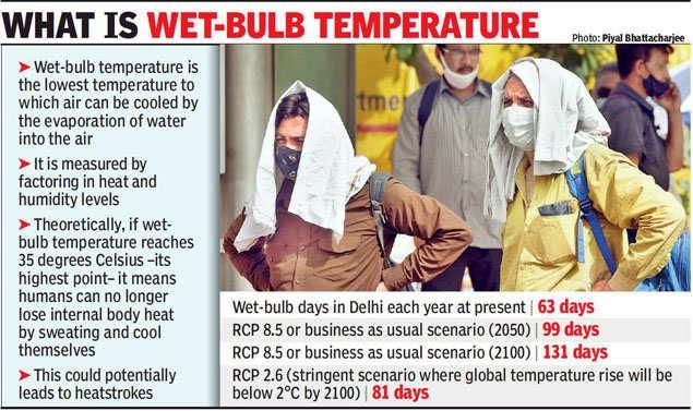
INSTA PT 2022 EXCLUSIVE (GEOGRAPHY)
NOTES
11. KAILASH RANGE..................................................................................................... 28
12. ALAKNANDA RIVER ................................................................................................ 29
13. DURAND LINE ........................................................................................................ 29
14. PENSILUNGPA GLACIER ......................................................................................... 29
15. UMLING LA............................................................................................................ 30
16. CATTLE ISLAND ...................................................................................................... 30
17. RIVER LUKHA ......................................................................................................... 30
18. RISHIGANGA .......................................................................................................... 30
19. PANJSHIR VALLEY .................................................................................................. 31
20. INDO- PACIFIC ....................................................................................................... 31
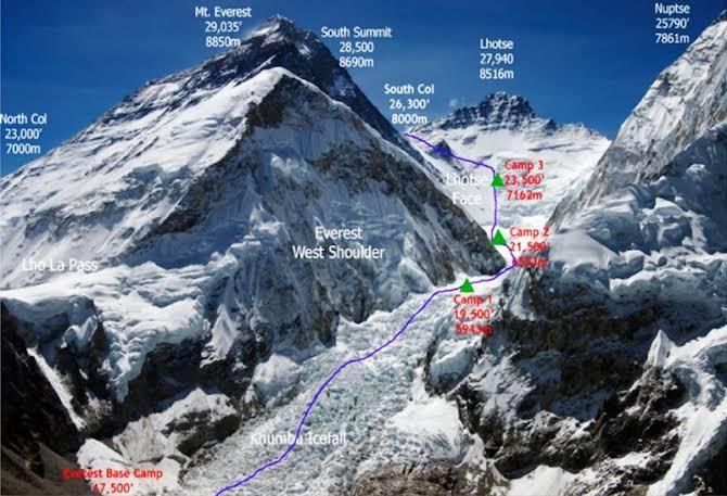
21. SOUTH COL GLACIER ............................................................................................. 31
22. DIEGO GARCIA ....................................................................................................... 31
23. MALI ..................................................................................................................... 32
24. TONGA VOLCANIC ERUPTION ................................................................................ 32
25. FALKLAND ISLANDS ............................................................................................... 32
26. NORD STREAM 2 PIPELINE: .................................................................................... 33
27. TAIWAN ................................................................................................................ 33
28. WEST BANK ........................................................................................................... 33
29. SOUTH CHINA SEA ................................................................................................. 34
30. LITHUANIA ............................................................................................................ 34
31. EAST KALIMANTAN............................................................................................... 34
32. HORN OF AFRICA ................................................................................................... 35
33. GUINEA ................................................................................................................. 35
34. HONDURAS ........................................................................................................... 35
35. PILLAR OF SHAME.................................................................................................. 35
36. BALTIC SEA ............................................................................................................ 36
37. GOLAN HEIGHTS .................................................................................................... 36
38. STRAIT OF HORMUZ .............................................................................................. 36
39. ADDU ATOLL ......................................................................................................... 36
40. SUEZ CANAL .......................................................................................................... 36
41. ENGLISH CHANNEL ................................................................................................ 37
42. GULF OF ADEN ...................................................................................................... 37
43. RED SEA ................................................................................................................ 37
44. SENKAKU ISLANDS ................................................................................................. 37
45. BARBADOS ............................................................................................................ 38
46. QEQERTAQ AVANNARLEQ: .................................................................................... 38
47. BLACK SEA ............................................................................................................. 38
48. VORUKH ................................................................................................................ 39
49. KACHIN PEOPLE ..................................................................................................... 39
50. DAHLA DAM .......................................................................................................... 39
51. MOUNT SINABUNG ............................................................................................... 39
52. BELARUS ............................................................................................................... 39
53. CALI....................................................................................................................... 40
54. SAHEL.................................................................................................................... 40
55. DOOMSDAY GLACIER ............................................................................................. 40
56. BHASAN CHAR ....................................................................................................... 40
Dams and River Water Sharing Agreements ................................................................ 41
1. INDUS WATER TREATY .............................................................................................. 41
www.insightsonindia.com 2 InsightsIAS
INSTA PT 2022 EXCLUSIVE (GEOGRAPHY)

                                                                                                                                     NOTES
2.   KEN-BETWA LINK PROJECT....................................................................................... 41
3.   KRISHNA RIVER WATER DISPUTE ............................................................................... 42
4.   MEKEDATU ISSUE ..................................................................................................... 43
5.   MULLAPERIYAR DAM ................................................................................................ 44

www.insightsonindia.com                                                 3                                                      InsightsIAS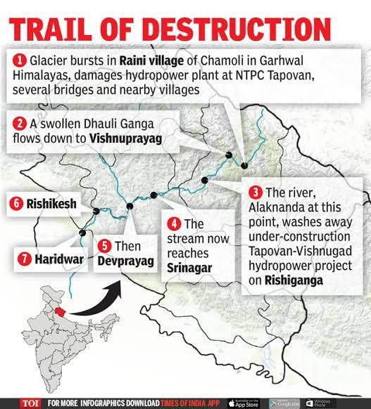
INSTA PT 2022 EXCLUSIVE (GEOGRAPHY)

                                                                                                              NOTES
    Important Geophysical phenomena and geographical features
1. Geomagnetic storm
Recently, Elon Musk’s Starlink has lost 40 satellites that were caught in a geomagnetic storm a
day after they were launched.

What are Geomagnetic Storms?
Geomagnetic storms are caused when events such as solar flares can send higher than normal
levels of radiation towards Earth. This radiation interacts with the Earth's magnetic field causing a
geomagnetic storm.

Causes:
The disturbance that drives the magnetic storm may be a solar coronal mass ejection (CME) or
(much less severely) a co-rotating interaction region (CIR), a high-speed stream of solar wind
originating from a coronal hole.

Effects of Geomagnetic storms:
● Effects from the geomagnetic storm can range from the appearance of auroras or the
    northern and southern lights to disruptions in communications systems due to high
    radiation. This would make it difficult to communicate with others on Earth.

2. Tonga Volcanic Eruption
Recently, a volcano erupted in the southern Pacific Island of Tonga, which triggered Tsunami
waves around the Pacific.
    ● It is an Undersea Volcanic Eruption consisting of two small uninhabited islands, Hunga-
         Ha’apai and Hunga-Tonga.
The Tonga Islands occur along the Ring of Fire—a perimeter of heightened volcanic and seismic
activity that encircles the Pacific Ocean basin.

www.insightsonindia.com                                     4                                           InsightsIAS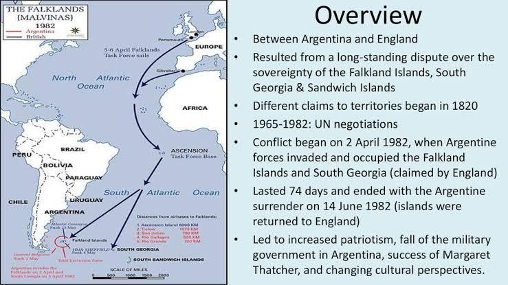
INSTA PT 2022 EXCLUSIVE (GEOGRAPHY)

                                                                                                             NOTES

What is the Ring of Fire?
The Ring of Fire is a Pacific region home to over 450 volcanoes, including three of the world’s four
most active volcanoes – Mount St. Helens in the USA, Mount Fuji in Japan and Mount Pinatubo in
the Philippines. It is also sometimes called the circum-Pacific belt.
● Around 90% of the world’s earthquakes occur in the Ring of Fire, and 80% of the world’s
    largest earthquakes.

Location:
● It stretches along the
    Pacific Ocean
    coastlines, where the
    Pacific Plate grinds
    against other, smaller
    tectonic plates that
    form the Earth’s crust –
    such as the Philippine
    Sea plate and the
    Cocos and Nazca Plates
    that line the edge of
    the Pacific Ocean.
● The 40,000 kilometre
    horse-shoe-shaped ring loops from New Zealand to Chile, passing through the coasts of Asia
    and the Americas on the way.

Risk:

www.insightsonindia.com                                    5                                           InsightsIAS
INSTA PT 2022 EXCLUSIVE (GEOGRAPHY)

                                                                                                               NOTES
The people most at risk from activity in the Ring of Fire are in the US west coast, Chile, Japan and
island nations including the Solomon Islands. These areas are most at risk because they lie on so-
called subduction zones – which are boundaries that mark the collision between two of the
planet’s tectonic plates.

How was the Ring of Fire formed?
The Ring of Fire is the result from subduction of oceanic tectonic plates beneath lighter
continental plates. The area where these tectonic plates meet is called a subduction zone.

Why does the Ring of Fire trigger earthquakes?
● The world’s deepest earthquakes happen in subduction zone areas as tectonic plates scrape
  against each other – and the Ring of Fire has the world’s biggest concentration of subduction
  zones.
● As energy is released from the earth’s molten core, it forces tectonic plates to move and they
  crash up against each other, causing friction. The friction causes a build-up of energy and
  when this energy is finally released it causes an earthquake. If this happens at sea it can cause
  devastating tsunamis.
● Tectonic plates usually only move on average a few centimetres each year, but when an
  earthquake strikes, they speed up massively and can move at several metres per second.

Why Indonesia is vulnerable to earthquakes?
Indonesia sit along the Ring of Fire region, an area where most of the world’s volcanic eruptions
occur. The Ring of Fire has seen a large amount of activity in recent days, but Indonesia has been
hit hard due to its position on a large grid of tectonic plates.
Indonesia is at the meeting point of three major continental plates – the Pacific, the Eurasian
and the Indo-Australian plates – and the much smaller Philippine plate. As a result, several
volcanoes on the Indonesian islands are prone to erupting. Indonesia is home to roughly 400
volcanoes, out of which 127 are currently active, accounting for about a third of the world’s active
volcanoes.

3. Cyclone
Cyclones are formed over the oceanic water in the
tropical region.
In this region, the sunlight is highest which results in
warming of land and water surface. Due to warming of
the surface, the warm moist air over the ocean rises
upwards following which cool air rushes in to fill the void,
they too get warm and rise — the cycle continues.

But what creates the spin?
Wind always blows from high pressure to low pressure
areas. High pressure areas are created in the cold region
while low is created in the warm regions. Polar regions are high pressure areas as the amount of
sunlight here is less than the tropical region. So, wind blows from polar regions to tropical regions.
● Then comes the Earth's movement, which is west to east. The Earth's rotation on its axis
    causes deflection of the wind (in the tropical region as the speed of spinning of Earth is
    higher compared to polar sides due to its spherical shape) Wind coming from the Arctic is
    deflected to the right while Antarctic wind deflects to the left side.
● So, wind is already blowing in a direction. But when it reaches the warmer place, cool air
    starts getting attracted to the centre to fill the gap. So while moving to the centre, cool air
    keeps getting deflected resulting in circulation of wind movement — this process continues
    until the cyclone hits the land.

www.insightsonindia.com                                        6                                         InsightsIAS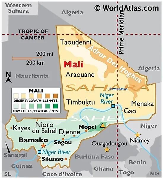
INSTA PT 2022 EXCLUSIVE (GEOGRAPHY)

                                                                                                              NOTES
What happens when a cyclone hits the land?
Cyclone dissipates when it hits the land as the warm water that rises and creates space for cool
water is no longer available on land. Also, the moist air that rises up forms clouds leading to rains
that accompany gusting winds during cyclones.

What are the different parts of a
cyclone’s structure?
The eye: The eye of the storm is the
centre. It’s a relatively calm space.
When the eye passes over an area,
winds slow down and everything feels
like it has cleared up. The part that
comes after the eye usually inflicts the
most damage.

The eyewall: This is where the most
effective part of a cyclone rests. The
eyewall houses extremely high wind speeds, causing damage to both lives and property. It is a
ring of thunderstorms, and changes in the eye or the eyewall affects the storm’s intensity.

Rainbands: These are the outer parts of a cyclone where sudden bursts of rain happen. There can
also be gaps betwen rainbands where no rain or wind occurs.

General factors responsible for the origin of Cyclones in Bay of Bengal region are:
1. Large sea surface with temperature higher than 27° C.
2. Presence of the Coriolis force enough to create a cyclonic vortex.
3. Small variations in the vertical wind speed.
4. A pre-existing weak low-pressure area or low-level-cyclonic circulation.
5. Upper divergence above the sea level system.

An analysis of past data of cyclones over North Indian Ocean (Bay of Bengal and Arabian Sea)
during the period from 1891 to 2020 indicates that:
● The frequency of “very severe cyclonic storms” has increased in recent years over the
    Arabian Sea. However, this has not measurably increased the threat to India's western coast,
    as most of these cyclones were making landfall in Oman and Yemen.
● The Eastern Coast remained far more vulnerable to “Extremely Severe Cyclones” than the
    Western coast, but there was nevertheless “no significant trend” in the frequency of
    Extremely Severe Cyclonic Storms (ESCS).
● The number of deaths due to cyclones has decreased significantly, as a result of the
    improvement in the early warning skill of the India Meteorological Department (IMD) under
    the Ministry of Earth Sciences (MoES).
● The effective mitigation measures and response actions by the National Disaster
    Management Authority (NDMA) and Ministry of Home Affairs (MHA) have also improved.

Factors responsible for this:
1. Surface temperatures in the Arabian Sea have increased rapidly during the past century due
    to global warming. Temp. Now is 1.2–1.4 °C higher than the temperature witnessed four
    decades ago. These warmer temperatures support active convection, heavy rainfall, and
    intense cyclones.
2. The rising temperature is also enabling the Arabian Sea to supply ample energy for the
    intensification of cyclones.

www.insightsonindia.com                                     7                                           InsightsIAS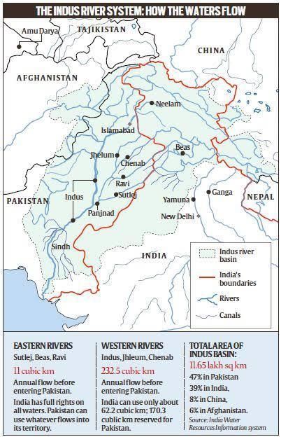
INSTA PT 2022 EXCLUSIVE (GEOGRAPHY)

                                                                                                            NOTES
3. The Arabian Sea is also providing conducive wind shear for cyclones. For instance, a higher
   level easterly wind drove the depression of Cyclone Ockhi from the Bay of Bengal to the
   Arabian Sea.

4. Bomb Cyclone
What is a Bomb Cyclone?
“Bombogenesis is the technical term. ‘Bomb cyclone’ is a
shortened version of it, better for social media.”
● It is a mid-latitude cyclone that intensifies rapidly.
● It has low pressure at its center, weather fronts and an
    array of associated weather, from blizzards to severe
    thunderstorms to heavy precipitation.

When is it formed? Generally, a bomb cyclone happens when atmospheric pressure in the
middle of the storm drops at least 24 millibars over 24 hours, quickly increasing in intensity. The
lower the pressure, the stronger the storm.

How is it different from hurricanes?
● It essentially amounts to a rapidly
   developing storm system, distinct from a
   tropical hurricane because it occurs over
   midlatitudes where fronts of warm and cold
   air meet and collide, rather than relying on
   the balmy ocean waters of late summer as a
   catalyst.
● Bomb cyclones have cold air and fronts:
   Cold air rapidly weakens hurricanes, while it
   is an essential ingredient for bomb cyclones.
● Bomb cyclones form during winter:
   Hurricanes form from late spring to early
   fall, while bomb cyclones form from late fall
   to early spring.
● Bomb cyclones form at higher latitudes: Hurricanes form in tropical waters, while bomb
   cyclones form over the northwestern Atlantic, northwestern Pacific and sometimes the
   Mediterranean Sea.

5. Naming of Cyclones
The World Meteorological Organisation (WMO) maintains rotating lists of names.
The word Tauktae has been suggested by Myanmar, which means 'gecko', a distinctively vocal
lizard, in the Burmese language.
● The name is the fourth from a new list of 169 names released by the IMD last year.

How are cyclones named?
● A WMO/ESCAP (World Meteorological Organisation/United Nations Economic and Social
   Commission for Asia and the Pacific) Panel on Tropical Cyclones agreed in principle to assign
   names to the tropical cyclones in the Bay of Bengal and the Arabian Sea during its 27th
   session held in Muscat, Sultanate of Oman, in 2000.
● The naming of the tropical cyclones over the north Indian Ocean commenced from September
   2004, with names provided by eight members, starting with Bangladesh, followed by India.
   Since then, another five countries have joined the Panel.
● The Regional Specialised Meteorological Centre (RSMC), New Delhi is responsible for naming
   the cyclonic storms formed over the Bay of Bengal and the Arabian Sea when they reach the
   relevant intensity.

www.insightsonindia.com                                    8                                          InsightsIAS
INSTA PT 2022 EXCLUSIVE (GEOGRAPHY)

                                                                                                            NOTES
There are six RSMCs in the world, including the IMD and five Tropical Cyclone Warning Centres.

6. Indian Ocean Dipole
It is an atmosphere-ocean coupled phenomenon in the tropical Indian Ocean (like the El Nino is in
the tropical Pacific), characterised by a difference in sea-surface temperatures.

Key features:
● IOD is the difference between the temperature of eastern (Bay of Bengal) and the western
    Indian Ocean (Arabian Sea).
● This temperature difference results into pressure difference which results in flowing of winds
    between eastern and western parts of Indian Ocean.
● A ‘positive IOD’ — or simply ‘IOD’ — is associated with cooler than normal sea-surface
    temperatures in the eastern equatorial Indian Ocean and warmer than normal sea-surface
    temperatures in the western tropical Indian Ocean.
● The opposite phenomenon is called a ‘negative IOD’, and is characterised by warmer than
    normal SSTs in the eastern equatorial Indian Ocean and cooler than normal SSTs in the
    western tropical Indian Ocean.

Impacts:
● Studies have shown that a positive IOD year sees more than normal rainfall over central India.
● A negative IOD complements El NiNo leading to severe drought.
● At the same time, Positive IOD results in more cyclones than usual in Arabian Sea.
● Negative IOD results in stronger than usual cyclogenesis (Formation of Tropical Cyclones) in
   Bay of Bengal. Cyclogenesis in Arabian Sea is suppressed during this time.

7. Cloudbursts
•   Cloudbursts are short-duration, intense rainfall events over a small area.
•   According to the India Meteorological Department (IMD), it is a weather phenomenon with
    unexpected precipitation exceeding 100mm/h over a geographical region of approximately
    20-30 square km.
•   A study published in 2020 studied the meteorological factors behind the cloudburst over the
    Kedarnath region.
•   They analysed atmospheric pressure, atmospheric temperature, rainfall, cloud water content,
    cloud fraction, cloud particle radius, cloud mixing ratio, total cloud cover, wind speed, wind
    direction, and relative humidity during the cloudburst, before as well as after the cloudburst.
•   The results showed that during the cloudburst, the relative humidity and cloud cover was at
    the maximum level with low temperature and slow winds.

www.insightsonindia.com                                   9                                           InsightsIAS
INSTA PT 2022 EXCLUSIVE (GEOGRAPHY)
NOTES
• Several studies have shown that climate change will increase the frequency and intensity of
cloudbursts in many cities across the globe.
• As temperatures increase the atmosphere can hold more and more moisture and this
moisture comes down as a short very intense rainfall for a short duration probably half an
hour or one hour resulting in flash floods in the mountainous areas and urban floods in the
cities.
8. Typhoon Rai
● Typhoon Rai, known in the Philippines
as Typhoon Odette, is currently a
powerful tropical cyclone over the
South China Sea which recently passed
through the Philippines.
● Rai became the third Category 5 super
typhoon to form in South China Sea
after Pamela of 1954 and Rammasun of
2014.
9. Hurricane Ida strikes USA
When do hurricanes occur?
The Atlantic Hurricane season runs from June to November and covers the Atlantic Ocean, the
Caribbean Sea and the Gulf of Mexico, while the Eastern Pacific Hurricane season runs from May
15 to November 30.
Hurricanes are categorized on the Saffir-Simpson Hurricane Wind Scale, which rates them on
a scale of 1 to 5 based on wind speed.
Hurricanes that reach category three or higher are called ‘major hurricanes’ because of their
potential to cause devastating damage to life and property.
What are hurricanes and how do they form?
Tropical cyclones or hurricanes use warm, moist air as fuel, and therefore form over warm ocean
waters near the equator.
As NASA describes it, when the warm, moist air rises upward from the surface of the ocean, it
creates an area of low air pressure below.
Air from the surrounding areas rushes to fill this place, eventually rising when it becomes
warm and moist too.
When the warm air rises and cools off, the moisture forms clouds. This system of clouds and
winds continues to grow and spin, fuelled by the ocean’s heat and the water that evaporates
from its surface.
● As such storm systems rotate faster and faster, an eye forms in the centre.
● Storms that form towards the north of the equator rotate counterclockwise, while those that
form to the south spin clockwise because of the rotation of the Earth.
10. La Niña effect on Indian subcontinent
What are EL Niño and La Niña?
They are two natural climate phenomena occurring across the tropical Pacific Ocean and
influence the weather conditions all over the world.
● While the El Niño period is characterised by warming or increased sea surface temperatures
in the central and eastern tropical Pacific Ocean, a La Niña event causes the water in the
eastern Pacific Ocean to be colder than usual.
● Together, they are called ENSO or El Niño-Southern Oscillation.
www.insightsonindia.com 10 InsightsIASINSTA PT 2022 EXCLUSIVE (GEOGRAPHY)
NOTES
What causes El Nino?
1. El Nino sets in when there is an
anomaly in the pattern.
2. The westward-blowing trade winds
weaken along the Equator and due
to changes in air pressure, the
surface water moves eastwards to
the coast of northern South America.
3. The central and eastern Pacific
regions warm up for over six months
and result in an El Nino condition.
Weather changes because of La Nina:
1. The Horn of Africa and central Asia will
see below average rainfall due to La
Niña.
2. East Africa is forecast to see drier-
than-usual conditions, which together
with the existing impacts of the desert
locust invasion, may add to regional
food insecurity.
3. It could also lead to increased rainfall
in southern Africa.
4. It could also affect the South West Indian Ocean Tropical Cyclone season, reducing the
intensity.
5. Southeast Asia, some Pacific Islands and the northern region of South America are expected
to receive above-average rainfall.
6. In India, La Niña means the country will receive more rainfall than normal, leading to floods.
11. Impact of climate change on El Niño-Southern Oscillation
There is a growing body of research suggesting that climate change can cause extreme and more
frequent El Niño and La Niña events.
● A study was conducted recently on this using one of South Korea’s fastest supercomputers,
Aleph.
Findings of the latest study:
1. Increasing atmospheric carbon dioxide can cause a “weakening of future simulated ENSO sea
surface temperature variability.”
2. Future El Niño events will lose heat to the atmosphere more quickly due to the evaporation of
water vapour.
3. In the future there will be a reduced temperature difference between the eastern and
western tropical Pacific, inhibiting the development of temperature extremes during the
ENSO cycle.
4. Also, there can be a weakening of tropical instability waves in the projected future, which can
cause a disruption of the La Niña event.
12. Atlantic Meridional Overturning Circulation (AMOC)
• Atlantic Meridional Overturning Circulation (AMOC) is a large system of ocean currents. It is
the Atlantic branch of the ocean conveyor belt or Thermohaline circulation (THC), and
distributes heat and nutrients throughout the world’s ocean basins.
• AMOC carries warm surface waters from the tropics towards the Northern Hemisphere,
where it cools and sinks. It then returns to the tropics and then to the South Atlantic as a
www.insightsonindia.com 11 InsightsIASINSTA PT 2022 EXCLUSIVE (GEOGRAPHY)
NOTES
bottom current. From there it is distributed to all ocean basins via the Antarctic circumpolar
current.
What happens if AMOC collapses?
• Gulf Stream, a part of the AMOC, is a warm current responsible for mild climate at the Eastern
coast of North America as well as Europe. Without a proper AMOC and Gulf Stream, Europe
will be very cold.
• Modelling studies have shown that an AMOC shutdown would cool the northern hemisphere
and decrease rainfall over Europe. It can also have an effect on the El Nino.
13. Leonids Meteor Shower
• Leonids Meteor Shower was active between November 6 and 30, 2021.
● The Leonids are considered to be a major shower that features the fastest meteors, which
typically travel at speeds of 71 km per second.
Meteor Shower vs Storm:
Every 33 years, a Leonid shower turns into a meteor storm, which is when hundreds to thousands
of meteors can be seen every hour.
● A meteor storm should have at least 1,000 meteors per hour. In 1966, a Leonid storm offered
views of thousands of meteors that fell through the Earth’s atmosphere per minute during a
period of 15 minutes.
● The last such storm took place in2002.
What are meteor showers?
● Meteors are bits of rock and ice that are ejected from comets as they manoeuvre around
their orbits around the sun.
● Meteor showers are witnessed
when Earth passes through the
trail of debris left behind by a
comet or an asteroid.
What Are the Differences Between
An Asteroid, Comet, Meteoroid,
Meteor and Meteorite?
1. Asteroid: A relatively small,
inactive, rocky body orbiting the
Sun.
2. Comet: A relatively small, at
times active, object whose ices
can vaporize in sunlight forming
an atmosphere (coma) of dust
and gas and, sometimes, a tail of
dust and/or gas.
3. Meteoroid: A small particle from
a comet or asteroid orbiting the
Sun.
4. Meteor: The light phenomena
which results when a meteoroid
enters the Earth’s atmosphere
and vaporizes; a shooting star.
5. Meteorite: A meteoroid that
survives its passage through the
www.insightsonindia.com 12 InsightsIASINSTA PT 2022 EXCLUSIVE (GEOGRAPHY)
NOTES
Earth’s atmosphere and lands upon the Earth’s surface.
14. Heat dome
Parts of Canada and USA were reeling under severe heat wave caused due to a heat dome.
What Is A Heat Dome?
A heat dome occurs when the atmosphere traps hot ocean air like a lid or cap.
● The scorching heat is ensnared in what is called a heat dome.
● High-pressure circulation in the atmosphere acts like a dome or cap, trapping heat at the
surface and favoring the formation of a heat wave.
Causes:
● This happens when strong, high-pressure atmospheric conditions combine with influences
from La Niña.
● This creates vast areas of sweltering heat that gets trapped under the high-pressure “dome“.
● The main cause is a strong change (or gradient) in ocean temperatures from west to east in
the tropical Pacific Ocean.
How is it created?
1. In a process known as convection, the gradient causes more warm air, heated by the ocean
surface.
2. This rises over the western Pacific, and decreases convection over the central and eastern
Pacific.
3. As prevailing winds move the hot air east, the northern shifts of the jet stream trap the air.
4. Thus winds move it toward land, where it sinks, resulting in heat waves.
Impact of a heat dome:
1. Lead to a sudden rise in fatalities due to extreme heat like conditions.
2. Trapping of heat can also damage crops, dry out vegetation and result in droughts.
3. The heat wave will also lead to rise in energy demand, especially electricity, leading to
pushing up rates.
4. Heat domes can also act as fuel to wildfires, which destroys a lot of land area in the US every
year.
5. Heat dome also prevents clouds from forming, allowing for more radiation from the sun to
hit the ground.
15. Heat waves
The India Meteorological Department (IMD) says heatwave is considered when the maximum
temperature of a station touches at least 40 degrees Celsius or more for plains, 37 degrees Celsius
or more for coastal regions and at least 30 degrees Celsius or more for hilly regions.
What are the criteria?
Heatwave is declared when the departure from normal temperature is by 4.5 to 6.4 degrees
Celsius and a severe heatwave is when the departure from normal is more than 6.4 degrees
Celsius.
www.insightsonindia.com 13 InsightsIASINSTA PT 2022 EXCLUSIVE (GEOGRAPHY)
NOTES
● For plains, based on actuals
maximum temperature, IMD
considers heatwave when actual
maximum temperature is more
than 45 degrees Celsius and
severe heatwave when it is more
than 47 degrees Celsius.
Reasons why India is experiencing
more heat waves are:
1. Magnified effect of paved and
concrete surfaces in urban areas
and a lack of tree cover.
2. Urban heat island effects can
make ambient temperatures feel
3 to 4 degrees more than what
they are.
3. More heat waves were expected
as globally temperatures had
risen by an average 0.8 degrees
in the past 100 years. Night-time
temperatures are rising too.
4. Higher daily peak temperatures and longer, more intense heat waves are becomingly
increasingly frequent globally due to climate change.
5. High intensity of UV rays in medium-high heat wave zone.
6. Combination of exceptional heat stress and a predominantly rural population makes India
vulnerable to heat waves.
16. Wet-bulb temperature
• When human beings feel hot, they cool themselves by sweating. However, if the humidity is
too high, sweating no longer works and one risks dangerous overheating.
In this case, “wet-bulb” temperature is used to measure both heat and humidity, helping
estimate whether conditions are safe for humans or not.
• Measured on a different scale compared with normal temperatures, where 35 degrees Celsius
is the maximum or threshold limit, wet-bulb temperature of 32 degrees can mean that even
fit, acclimatised people will not be able to work easily.
• With climate change, the number of such potentially dangerous days, where high heat and
humidity combine, are also increasing.
• At present, most of India experiences 12 to 66 days annually of this potentially deadly heat
and high humidity combination with hotspots along the east coast.
• A humid heatwave was a lot more dangerous compared with a dry heatwave.
• While the human skin has a temperature of around 35 degrees Celsius, a wet-bulb with the
same heat means sweat can no longer be used to cool the body.
• Wet-bulb temperature is measured by wrapping a wet cloth around the bulb of a
thermometer. It represents the lowest temperature air can reach by evaporation of water.
Internationally, the wet-bulb globe temperature is calculated by using a globe thermometer
and additionally accounting for solar radiation and wind speed.
www.insightsonindia.com 14 InsightsIASINSTA PT 2022 EXCLUSIVE (GEOGRAPHY)
NOTES
17. Cold waves
Conditions for declaring cold waves:
The IMD records a cold wave when the minimum temperature is equal to or less than 10 degrees
Celsius at a weather station in the plains and is 4.5 degrees to 6.4 degrees below the normal
temperature for that period.
For hilly regions, a cold wave is declared when the minimum temperature is less than or equal to
0 degrees Celsius and the minimum temperature is 4.5 degrees to 6.4 degrees below the normal.
Reasons for the Cold wave conditions in India:
• Impact of Western disturbance: Cold wave conditions form due to lack of western
disturbances. Western disturbances create precipitation and bring down day temperatures,
but night temperatures remain steady.
• Snowfall in the upper Himalayas: This creates a wind chill factor for the northern states of
India
• Downward subsidence of cold air: Subsiding air (from the upper Himalayas) further cools
down creating low-temperature conditions over North India for a longer period.
• La Nina is known to favor cold waves in North India.
o It increases the severity of cold conditions, also the frequency and area covered
under the grip of a cold wave become larger e.g. winters of October 2020 were colder
than usual (17.2 degrees Celsius, the lowest since 1962) due to the impact of La Nina
in the pacific.
Impact of cold wave conditions:
• Impact on agriculture in North India: It creates a wider gap between day and night
temperatures, this creates erratic winter conditions impacting agricultural practices in the
Rabi season.
www.insightsonindia.com 15 InsightsIASINSTA PT 2022 EXCLUSIVE (GEOGRAPHY)
NOTES
• Impact on Cash crops: It might also affect the productivity of cash crops such as coffee
(Coffee growth is extremely sensitive to variations in temperatures), which grows mainly in
south India.
• Impact on Human life: Cold wave conditions increase the risk of contracting flu, and could
also lead to symptoms like nosebleeds and runny nose. It was also said to be responsible for
the 2nd wave of COVID 19 in many parts of North India.
18. Daylight Saving Time
Also called summer time, it is the system for uniformly advancing clocks, so as to extend daylight
hours during conventional waking time in the summer months.
● The practice was first suggested in a whimsical essay by Benjamin Franklinin 1784.
● In countries in the Northern Hemisphere, clocks are usually set ahead one hour in late March
or in April and are set back one hour in late September or in October.
Objectives for using DST:
● Achieve energy efficiency: Increasing focus on energy efficiency due to climate change
because of over consumption of energy makes DST relevant. DST is thus an environmentally
sustainable concept.
● To ensure that the clocks show a later sunrise and later sunset — in effect ensure a longer
evening daytime.
● Completion of routine work an hour earlier.
● DST is meant to save energy.
Issues and concerns associated:
On Agriculture: One reason why farmers oppose DST is that grain is best harvested after dew
evaporates, so when field hands arrive and leave earlier in summer, their labor is less valuable.
Dairy farmers are concerned because their cows are sensitive to the timing of milking, so
delivering milk earlier disrupts their systems.
A spike in workplace injuries: A study of mining injuries across the U.S., found that there was a
spike in workplace injuries of nearly 6 percent on the Monday following the shift to daylight
saving time.
On labour and work productivity: Workplace productivity the week after DST drastically
decreases. People are tired and lethargic due to a reduction in sleep.
19. Discrete auroras on Mars
The UAE’s Hope spacecraft, which is orbiting Mars, has captured images of glowing atmospheric
lights known as discrete auroras.
Uniqueness of these auroras:
Unlike auroras on Earth, which are seen only near the north and south poles, discrete auroras on
Mars are seen all around the planet at night time.
How are Martian auroras different?
1. Unlike Earth, which has a strong magnetic field, the Martian magnetic field has largely died
out. This is because the molten iron at the interior of the planet– which produces magnetism–
has cooled.
2. However, the Martian crust, which hardened billions of years ago when the magnetic field
still existed, retains some magnetism.
3. So, in contrast with Earth, which acts like one single bar magnet, magnetism on Mars is
unevenly distributed, with fields strewn across the planet and differing in direction and
strength.
www.insightsonindia.com 16 InsightsIASINSTA PT 2022 EXCLUSIVE (GEOGRAPHY)
NOTES
4. These disjointed fields channel the solar wind to different parts of the Martian atmosphere,
creating “discrete” auroras over the entire surface of the planet as charged particles interact
with atoms and molecules in the sky– as they do on Earth.
The Northern Lights, also known as aurora borealis, are usually witnessed far up in the polar
regions or the high latitude regions of Europe. But, they could be visible in parts of Illinois and
Pennsylvania in the US.
Why?
This is due to a solar flare, which emerged from a Sunspot. The flare is accompanied by a
Coronal Mass Ejection (CME) — a large bubble of radiation and particles emitted by the Sun that
explodes into space at high speed. This causes the Northern Lights to be visible in more number
of areas than usual.
What is Aurora?
An Aurora is a display of light in the sky predominantly seen in the high latitude regions (Arctic
and Antarctic). It is also known as a Polar light.
Types:
There are two types- the aurora borealis and aurora australis – often called the northern lights
and southern lights.
Where do they occur?
They commonly occur at high northern and southern latitudes, less frequent at mid-latitudes, and
seldom seen near the equator.
Colors:
While usually a milky greenish color, auroras can also show red, blue, violet, pink, and white.
These colors appear in a variety of continuously changing shapes.
Science behind their occurrence:
● Auroras are a spectacular sign that our planet is electrically connected to the Sun. These light
shows are provoked by energy from the Sun and fueled by electrically charged particles
trapped in Earth’s magnetic field.
● The typical aurora is caused by collisions between fast-moving electrons from space with the
oxygen and nitrogen in Earth’s upper atmosphere.
● The electrons—which come from the Earth’s magnetosphere, the region of space controlled
by Earth’s magnetic field —transfer their energy to the oxygen and nitrogen atoms and
molecules, making them “excited”.
● As the gases return to their normal state, they emit photons, small bursts of energy in the
form of light.
● When a large number of electrons come from the magnetosphere to bombard the
atmosphere, the oxygen and nitrogen can emit enough light for the eye to detect, giving us
beautiful auroral displays.
www.insightsonindia.com 17 InsightsIASINSTA PT 2022 EXCLUSIVE (GEOGRAPHY)
NOTES
Where do they origin?
They origin at altitudes of 100 to more than 400 km.
Why do auroras come in different colors and
shapes?
The color of the aurora depends on which gas —
oxygen or nitrogen — is being excited by the
electrons, and on how excited it becomes. The color
also depends upon how fast the electrons are
moving, or how much energy they have at the time of
their collisions.
Effects:
● Auroras affect communication lines, radio lines and power lines.
● It should also be noted here that Sun’s energy, in the form of solar wind, is behind the whole
process.
20. NASA solves mystery of Jupiter's X-Ray Auroras
Jupiter has Auroras near both its poles which emit X-rays. However, scientists were puzzled
about the reason behind these X-Ray emissions.
● Now, combining data from Juno mission and European Space Agency's XMM-Newton
mission, NASA has solved this puzzle.
What's the reason behind this phenomenon?
Auroras are caused by ions crashing into Jupiter's atmosphere. These ions are 'surfing' the
electromagnetic waves in Jupiter's magnetic field to enter the planet's atmosphere.
About Juno:
Juno was launched in 2011 on a mission to study Jupiter’s composition and evolution. It’s the first
spacecraft to orbit Jupiter since Galileo.
● Juno's primary goal is to reveal the story of Jupiter's formation and evolution.
XMM-Newton mission:
Also known as the High Throughput X-ray Spectroscopy Mission and the X-ray Multi-Mirror
Mission, it is an X-ray space observatory launched by the European Space Agency in December
1999.
● It is part of ESA's Horizon 2000 programme.
● The spacecraft is tasked with investigating interstellar X-ray sources, performing narrow- and
broad-range spectroscopy, and performing the first simultaneous imaging of objects in both
X-ray and optical (visible and ultraviolet) wavelengths.
21. Summer solstice
June 21- this day is referred to as the summer solstice, the longest day of the summer season. It
occurs when the sun is directly over the Tropic of Cancer.
www.insightsonindia.com 18 InsightsIASINSTA PT 2022 EXCLUSIVE (GEOGRAPHY)
NOTES
What causes this?
Solstice means “sun stands still” in Latin.
Solstice is an astronomical event, caused by Earth’s
tilt on its axis and its motion in orbit around the
sun.
At the June solstice, Earth is positioned in its orbit so
that our world’s North Pole is leaning most toward
the sun.
● As seen from Earth, the sun is directly overhead
at noon 23 1/2 degrees north of the equator, at
an imaginary line encircling the globe known as
the Tropic of Cancer – named after the
constellation Cancer the Crab. This is as far north
as the sun ever gets.
Implications:
1. All locations north of the equator have days longer than 12 hours at the June solstice.
Meanwhile, all locations south of the equator have days shorter than 12 hours.
2. This day is characterised by a greater amount of energy received from the sun. According to
NASA, the amount of incoming energy the Earth received from the sun on this day is 30 per
cent higher at the North Pole than at the Equator.
What is the winter solstice?
21st December or the Winter Solstice marks the shortest day of the year in the Northern
Hemisphere.
● It is the shortest day and longest night of the year in the Northern Hemisphere and is also
known as the ‘first day of winter’ in the Northern Hemisphere as well as ‘Hiemal solstice
or Hibernal solstice’.
● During this, countries in the Northern Hemisphere are farthest from the Sun and the Sun
shines overhead on the Tropic of Capricorn (23.5° south).
22. Anti-hail guns
To help out horticulturists who face crop damage due to hailstorms, the Himachal Pradesh
government tested the use of indigenously developed ‘anti-hail guns’.
What is hail?
Hail is produced by cumulonimbus clouds, which are generally
large and dark and may cause thunder and lightning.
● In such clouds, winds can blow up the water droplets to
heights where they freeze into ice. The frozen droplets begin
to fall but are soon pushed back up by the winds and more
droplets freeze onto them, resulting in multiple layers of ice
on the hailstones.
● This fall and rise is repeated several times, till the hailstones
become too heavy and fall down.
What are 'anti-hail guns'?
● An anti-hail gun is a machine which generates shock waves to
disrupt the growth of hailstones in clouds.
● It comprises a tall, fixed structure somewhat resembling an
invert ed tower, several metres high, with a long and narrow
cone opening towards the sky.
www.insightsonindia.com 19 InsightsIASINSTA PT 2022 EXCLUSIVE (GEOGRAPHY)
NOTES
● The gun is “fired” by feeding an explosive mixture of acetylene gas and air into its lower
chamber, which releases a shock wave (waves which travel faster than the speed of sound,
such as those produced by supersonic aircraft).
● These shock waves supposedly stop water droplets in clouds from turning into hailstones, so
that they fall simply as raindrops.
23. Climate change causing a shift in Earth’s axis
According to a study, due to the significant melting of glaciers because of global temperature rise,
our planet’s axis of rotation has been moving more than usual since the 1990s.
Implications:
While this change is not expected to affect daily life, it can change the length of the day by a few
milliseconds.
What is the Earth’s axis?
The Earth’s axis of rotation is the line along which
it spins around itself as it revolves around the Sun.
The points on which the axis intersects the planet’s
surface are the geographical north and south
poles.
How it shifts?
The location of the poles is not fixed, however, as
the axis moves due to changes in how the Earth’s
mass is distributed around the planet. Thus, the
poles move when the axis moves, and the
movement is called “polar motion”.
● According to NASA, data from the 20th century shows that the spin axis drifted about 10
centimetres per year. Meaning over a century, polar motion exceeds 10 metres.
● Generally, polar motion is caused by changes in the hydrosphere, atmosphere, oceans, or
solid Earth.
What the new study says?
● Since the 1990s, climate change has caused billions of tonnes of glacial ice to melt into
oceans. This has caused the Earth’s poles to move in new directions.
● As per the study, the north pole has shifted in a new eastward direction since the 1990s,
because of changes in the hydrosphere (meaning the way in which water is stored on Earth).
● From 1995 to 2020, the average speed of drift was 17 times faster than from 1981 to 1995.
Also, in the last four decades, the poles moved by about 4 metres in distance.
Latest factors behind this change:
● The faster ice melting, change in non‐glacial regions due to climate change and unsustainable
consumption of groundwater for irrigation and other anthropogenic activities.
● As millions of tonnes of water from below the land is pumped out every year for drinking,
industries or agriculture, most of it eventually joins the sea, thus redistributing the planet’s
mass.
24. Lineament
A lineament is a linear feature in a landscape dictated by an underlying geological structure such
as a fault.
Context:
www.insightsonindia.com 20 InsightsIASINSTA PT 2022 EXCLUSIVE (GEOGRAPHY)
NOTES
According to a recent study, an unfamiliar lineament is one factor behind frequent earthquakes in
northern Assam’s Sonitpur area.
Why there are frequent earthquakes in Assam?
According to the Geological Survey of India (GSI), Sonitpur district lies within a tectonically
complex triangular area bounded by the east-west trending Atherkhet Fault, the northwest-
southeast trending Kopili Fault and a north-south trending lineament.
Why North east is vulnerable?
1. The Siang Fracture, Yemla Fault, Namula Thrust and Canyon Thrust are spread across the
northeast and are active along with Main Himalayan Thrust, Main Boundary Thrust, Main
Central Thrust and several subsidiary faults.
2. The northeast is demarcated as Seismic Zone V, which indicates a zone with high
vulnerability.
3. The Indian plate is moving northeast toward the Eurasian plate in the Himalayan region, their
oblique collision and release of stress and strain accumulated in the local tectonic or fault
environments lead to earthquakes.
25. Himalayan Frontal Thrust (HFT)
• Himalayan Frontal Thrust (HFT) also known as the Main Frontal Thrust (MFT), is a geological
fault along the boundary of the Indian and Eurasian tectonic plates.
• The Kopili Fault is a 300-km northwest-southeast trending fault from the Bhutan Himalaya to
the Burmese arc.
• A fault is “a fracture along which the blocks of crust on either side have moved relative to one
another parallel to the fracture”. When an earthquake occurs on one of these faults, the rock
on one side of the fault slips with respect to the other. The fault surface can be vertical,
horizontal, or at some angle to the surface of the earth.
• The Northeast is located in the highest seismological zone.
• The collision zone between India and Eurasia along the tremendous Himalayan mountain
range has one of the highest seismic hazards in the world.
26. Venus
Scientists have obtained new data about Venus by bouncing radio waves off Venus.
www.insightsonindia.com 21 InsightsIASINSTA PT 2022 EXCLUSIVE (GEOGRAPHY)
NOTES
● The researchers transmitted radio waves toward Venus 21 times from 2006 to 2020 from
NASA's Goldstone Antenna in the Mojave Desert of California and studied the radio echo,
which provided information on certain planetary traits.
Latest findings:
1. The study measured the tilt of the Venusian axis and size of the planet's core.
2. A single Venusian rotation takes 243.0226 Earth days. That means a day lasts longer than a
year on Venus, which makes a complete orbit around the sun in 225 Earth days.
3. The Venusian planetary core has a diameter of about 4,360 miles (7,000 km), comparable to
Earth's core.
4. The study calculated the Venusian tilt at about 2.64 degrees. Earth's is about 23.5 degrees.
About Venus:
● Venus, the second planet from the sun, is similar in structure but slightly smaller than Earth.
● It is called the Earth’s twin because of their similar sizes.
● Above its foreboding landscape is a thick and toxic atmosphere that consists primarily of
carbon dioxide, with clouds of sulfuric acid droplets.
● With a runaway greenhouse effect, its surface temperatures reach 880 degrees Fahrenheit
(471 degrees Celsius), hot enough to melt lead.
● Venus is one of just two planets that rotate from east to west. Only Venus and Uranus have
this "backwards" rotation.
● In another quirk, its day-night cycle - the time between sunrises as opposed to the length of a
single axial spin - takes 117 Earth days because Venus rotates in the direction opposite of its
orbital path around the sun.
● For those on Earth, Venus is the second-brightest object in the sky after the moon. It appears
bright because of its thick cloud cover that reflects and scatters light.
● The planet’s thick atmosphere traps heat and is the reason that it is the hottest planet in the
solar system, despite coming after Mercury, the closest planet to the Sun. Surface
temperatures on Venus can go up to 471 degrees Celsius, which is hot enough to melt lead,
NASA notes.
● Venus also does not have a moon and no rings.
27. Monsoon
Criteria — as defined by the IMD to confirm the arrival of monsoon over Kerala.
The criteria are:
1. Rain-bearing westerlies being at a minimum depth and speed.
2. At least 60% of the available 14 stations in Kerala and coastal Karnataka reporting rainfall of
2.5 mm or more for two consecutive days after May 10.
3. A certain degree of clouding, indicated by a parameter called ‘outgoing longwave radiation’
(OLR), being below 200 W/square metre.
Factors influencing the onset on Southwest
Monsoon:
The onset needs a trigger in the form of a weather
system in the proximity of the coastline. These
are ocean born phenomena which accentuate the
monsoon surge around the normal time of onset.
These include:
1. The low-pressure area or depression in the
Bay of Bengal during the last days of May or
the beginning of June.
www.insightsonindia.com 22 InsightsIASYou can also read