Hospital Local Area Plan 2012-2018 - June 2012 Extended until May 2022 - Limerick.ie
←
→
Page content transcription
If your browser does not render page correctly, please read the page content below
Hospital Local Area Plan
       2012-2018

                              June 2012
                     Extended until May 2022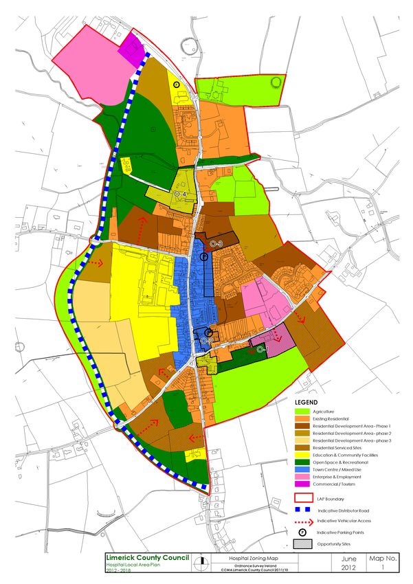
In accordance with the provisions of the Planning and Development
Acts 2000 – 2011, Section 20 (4A) this Local Area Plan came into
effect on 25th June 2012, four weeks from the date of its adoption
by elected members of Limerick County Council on the 28th May
2012.

On 20th April 2017 Limerick City & County Council extended the
duration of the Hospital Local Area Plan 2012 - 2018 for a further
five years, until May 2022.
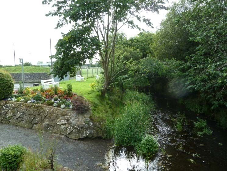
Table of Contents
Structure of the Plan                                                4

Chapter 1: Introduction                                              6
1.1  What is the Hospital Local Area Plan ( LAP)?                    6
1.2  Plan Area                                                       6
1.3  The Review Process                                              7
           1.3.1 Steps involved in the preparation of the LAP        7
           1.3.2 Strategic Environmental Assessment (SEA)            7
           1.3.3 Appropriate Assessment                              7
           1.3.4 Flood Risk Assessment                               8
1.4  Planning Context                                                8
           1.4.1 National Planning Context                           8
           1.4.2 Regional Planning Context                           9
           1.4.3 County Planning Context                             9
           1.4.4 Other Planning Guidelines                           10

Chapter 2: Context                                                   11
2.1  Geographical Context                                            11
2.2  Historic Evolution                                              11
2.3  Natural and Built Environment                                   14
2.4  Function                                                        15
2.5  Demographic and Socio-economic Context                          16
            2.5.1 Population                                         16
            2.5.2 Age Profile and dependency ratios                  17
            2.5.3 Education                                          17
            2.5.4 Employment                                         18
            2.5.5 Travel Patterns                                    19

Chapter 3: Plan Strategy                                             21
3.1  Policy Context                                                  21
3.2. Vision Statement                                                21
3.3  Strategic Policy                                                21
3.4  Evaluation of 2006 Hospital LAP                                 22
3.5  SWOT Analysis                                                   23
3.6  Population Targets and Zoning Requirements                      24
            3.6.1 Population Targets                                 24
            3.6.2 Land Currently available for housing development   25

Chapter 4: Housing                                                   27
4.1  Introduction                                                    27
4.2  Residential density, mix and phasing                            28
4.3  Serviced and low density sites                                  28
4.4  Infill Development - Residential                                30
4.5  Social Housing                                                  30
4.6  Traveller Accommodation                                         31

Chapter 5: Economic Development                                      32
5.1  Introduction                                                    32
5.2  Enterprise and Employment zoned land                            33

Hospital Local Area Plan 2012 – 2018                  1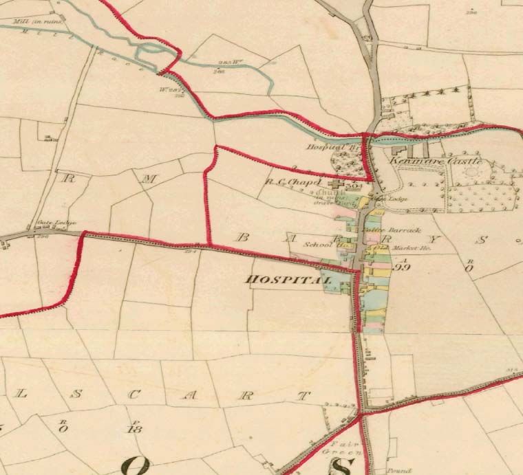
5.3    Small-scale business in residential areas               34
5.4    Retail and commercial development                       35
5.5    Tourism                                                 36

Chapter 6: Transport                                           37
6.1  Introduction                                              37
6.2  Movement and accessibility                                38

Chapter 7: Infrastructure                                      40
7.1  Introduction                                              40
7.2  Water Supply                                              40
7.3  Foul Sewerage                                             40
7.4  Surface Water Drainage                                    41
7.5  Flood Risk Management                                     41
7.6  Waste Management                                          42
7.7  Energy and Electricity                                    43
7.8  Access to Broadband and Telecommunications                43

Chapter 8: Environment and Heritage                            44
8.1  Introduction                                              44
8.2  Built Environment                                         44
            8.2.1 Protected Structures                         44
            8.2.2 Architectural Conservation Area (ACA)        45
8.3  Archaeological Heritage                                   47
8.4  Natural Environment                                       48
8.5  Climate Change                                            50

Chapter 9: Community and Recreation                            51
9.1  Introduction                                              51
9.2  Community and Recreation                                  51
9.3  Education and Childcare Facilities                        52
9.4  Health Facilties                                          52

Chapter 10: Urban Design                                       54
10.1 Introduction                                              54
10.2 Derelict and Vacant sites                                 55
10.3 Hospital Opportunity Areas                                56

Chapter 11: Land Use Zoning                                    64
11.1 Purpose of Land Use Zoning                                64
11.2 Non Conforming Uses                                       65
11.3 Land Use Zoning Categories                                65
11.4 Land Use Matrix                                           67

Appendices
Appendix 1: Maps
       Map 1                Zoning Map
       Map 2                Amenity Map
       Map 3                Protected Structures and ACA map
       Map 4                Predictive Flood Zones

Hospital Local Area Plan 2012 – 2018                   2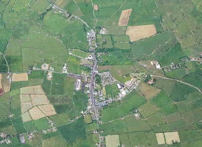
Appendix 2: Flood Risk Assessment
Appendix 3 SEA Screening and AA Screening Summary
Appendix 4 Protected Structures of Hospital and list of traditional building
materials found in County Limerick
Appendix 5 Recorded Monuments
Appendix 6 Glossary and Abbreviations
List of Tables
Table 2.1 Number of retail units, Hospital, by category 15
Table 3.1 SWOT Analysis of Hospital 23
Table 3.2 Hospital population targets and residential units for additional
population 25
Table 3.3 Residential zoned land, required and proposed 26
Table 11.1 Total Zoned Lands 64
Table 11.2 Hospital Land Use Zoning Matrix 2012 – 2018 68
List of Figures
Figure 1.1 Location of Hospital 6
Figure 1.2 Hierarchy of Spatial Planning Policies 8
Figure 2.1 Map of Hospital, 1839 12
Figure 2.2 Map of Hospital, 1901 13
Figure 2.3 Aerial Photograph of Hospital, 2006 13
Figure 2.4 Map of Hospital OSI 2010 14
Figure 2.5 Example of Protected Structure 15
Figure 2.6 Population and number of dwelling units 16
Figure 2.7 Age profile of Hospital E, Census 2006 17
Figure 2.8 Persons aged 15 years + by education completed, Hospital
ED, Census 2006 18
Figure 2.9 Persons at work or unemployed by occupation, Hospital
ED, Census 2006 19
Figure 2.10 Places of Work, Hospital ED, 2006 20
Figure 2.11 Persons aged 5 years + by means of travel to work, school
or college 20
Figure 4.1 Examples of housing in Hospital 27
Figure 4.2 Examples of housing in Hospital 27
Figure 5.1 Part of Hospital town centre – Main Street 33
Figure 5.2 Hospital Food Centre 33
Figure 5.3 Panoramic view of Hospital from the site of proposed hotel 36
Figure 8.1 Part of ACA Main Street 46
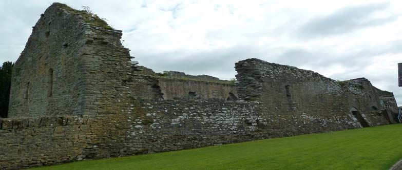
Figure 8.2 Ruins of Knights Hospitallers Abbey 48
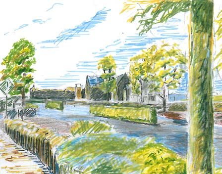
Figure 8.3 Mahore River and picnic area 50
Figure 9.1 Scoil Eoin Baiste 53
Figure 9.2 Community Hall, Main Street 53
Hospital Local Area Plan 2012 – 2018 3
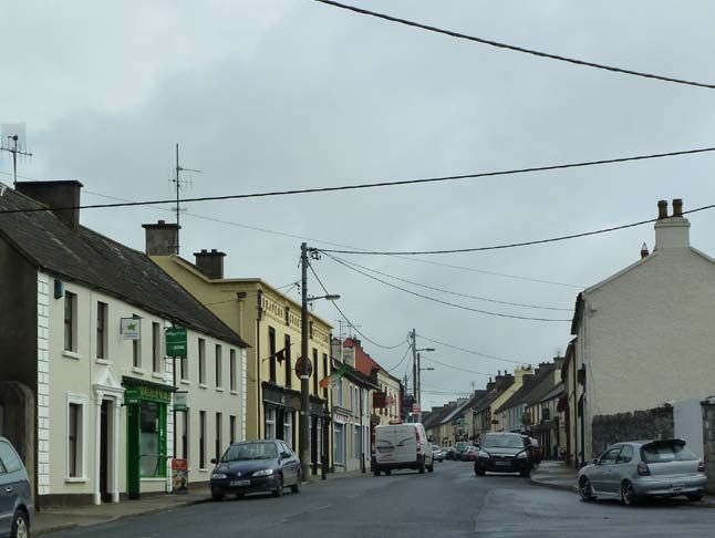
Structure of the Plan
Chapter 1 Introduction
This section introduces the Hospital Local Area Plan (LAP) 2012 – 2018, and
the statutory context which informs the LAP.

Chapter 2 Context
This chapter describes the geographical location of the town: its historical
evolution, present day function and an overview of the socio-economics and
demographics of the town, specifically population, age profile, employment,
education and travel patterns. Note that during the preparation of the LAP the
data from the 2011 Census was not available to the Council.

Chapter 3 Plan Strategy
This chapter outlines the Council’s vision statement for the development of the
town, and the consequent strategic objective to achieve the vision statement.
A SWOT analysis of the town is undertaken bearing in mind the issues
identified by the various stakeholders who made submissions during the non-
statutory pre-draft stage. Importantly, this Chapter sets out the reasoning
behind the allocation of zoning and objectives of the proposed LAP based on
population projections. These population projections are detailed in Variation
No. 1 to the Limerick County Development Plan 2010 – 2016 as varied.

Chapter 4 Housing
Chapter 4 sets out the requirements of the Council regarding any proposed
residential development. This discussion includes the requirements of the
Limerick County Development Plan, residential density, design, housing mix
and phasing, infill development, social housing and traveller accommodation.

Chapter 5 Economic Development
This chapter outlines the labour market in Hospital based on the most up to
date census figures available at the time of preparation, including skills, and
education which effects employability. The Chapter discusses lands zoned for
enterprise and employment, mixed use, small-scale businesses in residential
areas and commercial, retail and tourism development in the town.

Chapter 6 Transport
This chapter briefly describes national and regional transport policy and how it
informs the Councils local transport objectives for the town of Hospital.

Chapter 7 Infrastructure
This chapter deals with water services infrastructure including water supply,
waste-water treatment, storm water drainage, flood risk management, waste
management, energy and electricity and access to broadband and
telecommunications.

Chapter 8 Environment and Heritage
This chapter deals with archaeological, architectural, the natural and built
heritage.  Topics assessed include Protected Structures, Architectural
Conservation Areas (ACAs), the natural environment and climate change.

Hospital Local Area Plan 2012 – 2018                      4
Chapter 9 Community and Recreation
Chapter 9 looks at provisions made by the Plan for education, health facilities,
open space and community infrastructure.

Chapter 10 Urban Design
Chapter 10 gives a brief overview of the Council’s requirements for the design
of future buildings and places. Four opportunity areas are identified as having
potential for development or significant environmental improvements.

Chapter 11 Land Use Zoning
This chapter describes the purpose of the various land use zones of the Plan.

Hospital Local Area Plan 2012 – 2018                       5
Chapter One - Introduction
1.1    What is the Hospital Local Area Plan (LAP)?
The Hospital Local Area Plan (LAP) is a legal document consisting of a public
statement of Limerick County Council’s planning policies for the town of
Hospital. This plan replaces the Hospital LAP 2006 - 2012. The aim of the
LAP is to establish a framework for the planned, coordinated and sustainable
development of the town of Hospital, including the conservation and
enhancement of its natural and built environment over the next six years and
beyond. The LAP provides guidance as to how this development can be
achieved, what new developments are needed, where public and private
resource inputs are required, and guidance for development proposed in the
plan area.

The plan builds on the review of the Hospital LAP 2006 - 2012, taking into
account recent key development trends and national, regional and local policy
developments. All planning applications in the town of Hospital will be
measured against the contents of this LAP and the current Limerick County
Development Plan 2010 – 2016 as varied.

The Hospital LAP must be read in conjunction with the Limerick County
Development Plan 2010 – 2016 as varied. Unless otherwise stated, the
general development plan policies, objectives and development management
standards still apply to the area.

1.2    Plan Area
The Hospital LAP covers approximately 1.1 square kilometres (110 hectares)
in area and falls into the Hospital Electoral Division (ED). It contains parts of
the townlands of Castlefarm, Millfarm, Barrysfarm, Coolscart, Coolalough and
Gotoon.
                         Figure 1.1 Location of Hospital

Hospital Local Area Plan 2012 – 2018                        6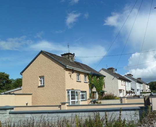
1.3    The Review Process
1.3.1 Steps involved in preparation of the plan
The review of the Local Area Plan commenced on the 20th August 2011 with
the publication of an issues paper entitled ‘Hospital Local Area Plan 2012 –
2018 – First Issues’. Its intention was to prompt discussion on local issues at
pre draft stage. Copies of the issues paper and an invitation to make a
submission were sent to local community and voluntary agencies in the area.
A public meeting was held in the area in early September 2011.

The LAP went on public display at County Buildings, area offices, libraries and
on the internet at www.lcc.ie for a period of six weeks from 5th November 2011
– 19th December 2011. Again, written submissions were invited. At the end of
the public consultation period a Manager’s Report was prepared on any
issues arising during the public consultation period and was submitted to the
Members of the Council for their consideration. Following the elected
members consideration of the Manager’s Report, the Council decided to
materially amend the proposed Local Area Plan, and a further period of four
weeks public consultation took place 16th March to 16th April 2012 on these
material alterations only. A further Managers Report on submissions regarding
proposed amendments, was then prepared for the Councillors who, having
considered the report, made the new Local Area Plan, with amendments on
the 28th May 2012. In accordance with the provisions of the Planning and
Development Acts 2000 – 2011, Section 20 (4A) this Local Area Plan came
into effect on 25th June 2012, four weeks from the date of its adoption by
elected members of Limerick County Council on the 28th May 2012.

Responsibility for making a local area plan rests with the elected members of
the Planning Authority.

1.3.2 Strategic Environmental Assessment (SEA)
The EU Directive on Strategic Environmental Assessment (SEA) requires all
European Union member states to systematically evaluate the likely
significant effects of implementing a plan or programme prior to its adoption.
The Plan does not fall within the thresholds for which a Strategic
Environmental Assessment (SEA) is mandatory. The Plan was screened in
line with “Implementation of SEA Directive (2001/42/EC): Assessment of
Certain Plans and Programmes on the Environment - Guidelines for Regional
Authorities and Planning Authorities” to determine whether or not a SEA
would nevertheless be appropriate. After consultation with the Environmental
Authorities it was determined by the Council that a full Environmental Report
was not required. See Appendix 3 for SEA screening summary.

1.3.3 Appropriate Assessment (AA)
In accordance with Articles 6(3) and 6(4) of the Habitats Directive the
Planning Authority undertook an Appropriate Assessment Screening Report of
the proposed plan which found that the plan would have no significant effects
on Natura 2000 sites.

Hospital Local Area Plan 2012 – 2018                       7
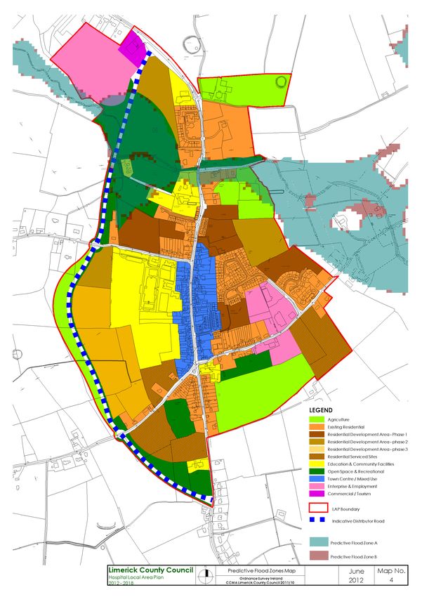
1.3.4 Flood Risk Assessment
A Stage One Flood Risk Assessment has been undertaken in support of the
Hospital LAP (see Appendix 2). The information gathered has informed the
Land Use Zoning Map included in this LAP. The LAP has adopted the
precautionary approach and lands which have been identified as potentially at
risk to flooding have been zoned for uses which are not considered
vulnerable.

1.4    Planning Context
In accordance with the Planning and Development Acts 2000 – 2011 the
proposed LAP has been informed by a hierarchy of national, regional, and
local spatial planning policies. See Figure 1.1 below.

              Figure 1.2    Hierarchy of Spatial Planning Policies

1.4.1 National Planning Context

1.4.1.1       National Spatial Strategy 2002 - 2020
The National Spatial Strategy for Ireland (NSS) is a twenty year planning
framework designed to achieve a better balance of social, economic and
physical development and population growth between regions. Its focus is on
people, on places and on building communities. The National Spatial Strategy
concentrates on a number of specific regions and their development by
identifying Gateway settlements throughout the country which are to be used
to support geographically balanced growth in the regions outside of Dublin.
Hospital is considered to play a complementary role to the development of the
Limerick – Ennis - Shannon Gateway as outlined in the Mid West Regional
Planning Guidelines.

1.4.1.2        National Development Plan 2007-2013
The National Development Plan (NDP) identifies investment funding for
significant projects in sectors such as health services, social housing,
education, roads, public transport, rural development, industry, and water and
waste services. The NDP is designed to strengthen and improve the

Hospital Local Area Plan 2012 – 2018                      8
international competitiveness of the country so as to support continued, but more balanced, economic and social development in line with the NSS. 1.4.2 Regional Planning Context 1.4.2.1 Mid West Regional Planning Guidelines 2010 - 2022 This document has been prepared in accordance with the overall policy frameworks established by the National Spatial Strategy and the National Development Plan 2007-2013. It sets clear objectives and targets to guide County Development Plans and Local Area Plans within the region, specifically in relation to future population, settlement strategy and development distribution and infrastructure investment priorities in line with the NDP 2007-2013. The Regional Planning Guidelines provide a wider area approach to the development of County Limerick. These guidelines look at Limerick in its regional context and identifies sub-regions or ‘zones’, with the core area of the region incorporating the Limerick Shannon Gateway. Hospital is located in zone 8. 1.4.2.2 Mid-West Area Strategic Plan (MWASP) A strategic planning, land use and transportation strategy for the Mid-West region is currently being developed. Its preparation is overseen by the County Councils of Limerick, North Tipperary, Clare and Limerick City Council. MWASP will provide for a comprehensive integrated plan for Land Use Planning and Transportation in the Mid-West Region over the next 30 years. 1.4.2.3 Retail Strategy for the Mid West Region 2010 - 2016 This strategy was prepared in 2010 on behalf of Counties Limerick and Clare and Limerick City Council. It addresses the retail needs, opportunities and issues of the Mid-West region and sets out an integrated strategic framework for retail planning in the Mid West over the period to 2016. 1.4.2.4 Joint Housing Strategy 2010 – 2017 The Housing Strategy has been prepared in accordance with Part V of the Planning and Development Acts 2000-2011 and covers the functional areas of Limerick County Council, Limerick City Council and Clare County Council. A critical objective of the Housing Strategy is to ensure the provision of housing for the existing and projected future populations in accordance with the principles of proper planning and sustainable development. The housing strategy aims to provide an equitable level of social housing and social integration. 1.4.3 County Planning Context 1.4.3.1 Limerick County Development Plan 2010 – 2016 as varied The Limerick County Development Plan 2010-2016 is the ‘parent’ document for this Hospital LAP, and thus the proposed LAP is made in accordance with the policies and objectives as set out in the County Development Plan. Hospital Local Area Plan 2012 – 2018 9
The Limerick County Development Plan 2010 – 2016 as varied sets out the
Council’s policy to steer future development in the county based on a
settlement hierarchy reflecting settlement function. It outlines population
targets and zoning requirements for settlements for the years 2016 and 2022
which must be incorporated into LAPs.

The settlement structure for County Limerick which is set out in the County
Development Plan designates Hospital as a Tier 4 settlement. Tier 4
settlements generally have a population of over 400 people and cater for the
daily and weekly needs of their inhabitants, and of the surrounding hinterland.
These settlements also provide a range of employment opportunities and
services appropriate to their size and function.

1.4.4 Other Planning Guidelines
Planning Authorities are required to take account of any policies and
guidelines issued by the Minister. For a comprehensive list of other policy
documents taken into account in preparing this plan refer to chapter 1 in the
Limerick County Development Plan 2010 – 2016 as varied.

Hospital Local Area Plan 2012 – 2018                      10
Chapter 2: Context
2.1    Geographical Context
Hospital is located approximately 30km south of Limerick city in the rural area
defined by the Limerick County Development Plan 2010 – 2016 as varied as
an area of Strong Agricultural Base. The road between Limerick and Cork via
Mitchelstown and Fermoy (R513) runs north-south through the town and
forms the Main Street. The regional road R516 linking Emly in the east with
Bruff and Croom in the west converges with the Limerick-Mitchelstown road in
the town. The R513 is defined as a Strategic Regional road in the County
Development Plan in reflection of its importance.

Hospital’s agricultural hinterland is largely lowland pastoral farming. The
Mahore river, a tributary of the Maigue flows through the north of the town in
an east – west direction confluencing with the Camog approximately 12km
downstream. The Camog in turn joins the Maigue just upstream of Croom.

The central core of the town is concentrated along Main Street. There are
distinctive districts in the town defined by their built form, natural settings and
history. The oldest part of the town is around the ruins of the abbey of Knights
Hospitallers and incorporates the grounds of Kenmare Castle.

2.2     Historic Evolution
Hospital town owes its name to a foundation of the Knights Hospitallers. The
Hospital of St. John of Jerusalem was established in the early 12th century for
infirmarians, who took the three perpetual vows, following the rule of St.
Augustine. 1 The preceptories were built as fortified manor houses or castles
rather than monasteries. The foundation of the Hospital of Any is accredited to
Geoffrey de Mariscis. 2 In 1215 the knights of the Vale of Anye obtained royal
privileges, this suggests that it was founded before this date. It became the
most important house of the Order in Ireland after Kilmainham. In the later 14th
century the preceptory was rented out, so the brother chaplain was probably
residing at Kilmainham. In 1541 the jurors reported that all the buildings were
standing and were necessary for the farmer, that 280 acres were held by
various tenants, other items included a water-mill and twelve cottages. 3

After the dissolution the preceptory, or a castle near it, was used as a
residence. 4 In 1578 the Castle was granted to W. Apsley, while in 1655 it was
held by T. Browne. The castle stood, according to tradition, not far from the
preceptory to the east of the bridge and on the north bank of the river. No
trace remains. The Civil Survey of the mid-seventeenth century records that
Hospital had two fairs a year, a market every week, and was the centre of
manorial rule as it had a Court; it also had a castle, sixty houses and a mill 5. It
1
  Gwynn & Hadcock 1988, Medieval religious houses in Ireland, Dublin, 332
2
  (ibid., 336)
3
  (ibid.,)
4
  Westropp 1906/07, ‘The ancient castles of the County of Limerick’, Proceedings of the Royal Irish Academy,
XXVI, North Eastern Baronies 55-108, Central & South-Eastern Baronies 143-264, 185
     5
       Simington, R.C. 1938 The Civil Survey AD 1654 – 1656, County of Limerick, Vol. IV, Dublin, 96.

Hospital Local Area Plan 2012 – 2018                                              11
was granted by Queen Elizabeth 1st to Valentine Browne who erected a castle
near the preceptory called Kenmare Castle. In 1831 there were 179 houses
recorded in the town; and by 1837 the town had 1121 inhabitants6.
By the end of the 19th century there was evidence for an upsurge in economic
and social improvements- a new school, in the grounds of a Convent of the
Presentation Order was constructed at the northern end of the town, on the far
side of the road there was a Parochial House in good grounds. Down the
street a Court House adjoins the barracks and Smithies have been built. In
the heart of the town is a creamery and a branch of the Munster and Leinster
bank has been opened. On the southern outskirts of Hospital a Dispensary
and Doctor’s Residence have been built. New housing was built along the
Knockainey and Emly roads.
During the first half of the 20th century, the mid-19th century town expanded
northwards along the Limerick road through developments undertaken mainly
by Limerick County Council, though there are individual houses found along
this stretch of road also. Most of these date from the past 30 years or so.
Expansion also took place along the Emly Road. A library was built by the
County Council and additional dwellings and commercial buildings, such as a
new creamery were also built. This creamery is now closed and disused.
Figure 2.1 Hospital First Edition Ordnance Survey c 1839
Not to scale
6
Lewis, S. 1837 A topographical dictionary of Ireland, Vols. 1 & 2, London, 10.
Hospital Local Area Plan 2012 – 2018 12Figure 2.2 Hospital Second Edition Ordnance Survey c1901
Not to scale
Figure 2.3 Aerial Photograph Hospital 2006
Hospital Local Area Plan 2012 – 2018 13Figure 2.4 Hospital Ordnance Survey 2010
Not to scale
Since 2006 thirty one houses have been built in a number of small schemes.
There is outstanding planning permission for an eighty bedroom hotel, sixty
six houses and a commercial development including 6 light industrial units, 6
warehouse units, offices, a retail warehouse, a car workshop and a car
showroom, located north of the town. There is also outstanding planning
permission for 28 houses on the Emly Road.
2.3 Natural and Built Environment
Hospital developed as a service and market town serving a wide rural area
with some small scale industry based on the economy of its rural hinterland.
Hospital is located in the Agricultural Lowlands as designated by the Limerick
County Development Plan 2010 – 2016 as varied. This lowland farming
landscape is defined by regular field boundaries with a developed hedgerow
system and the primary farming activity is pastoral or dairy farming. It has the
distinction of having the first farmer owned creamery in Ireland, which was
established in 1884 on the junction between Main Street and Knockainy
Road. There is no operating creamery in the town, the last creamery, on Emly
Road, having been closed for some years.
Most of the fabric of the town centre dates from the mid to late nineteenth
century with a few Georgian buildings. The economic functions which
accounts for the built fabric of the centre, owes much to the town’s nodal
position in east Limerick and the regional road network, the most important
road of which is the R513 from Limerick. The core of the town is therefore
concentrated along the R513. The town is strongly linear, especially in the
absence of any other streets of any significant importance in the core of the
town. The commercial core in the nineteenth century grew up to the south of
an older loose cluster of buildings around the ruins of the medieval abbey (the
Hospital Local Area Plan 2012 – 2018 14Knights Hospitallers) after which the town got its name, and in the estate of
the Earls of Kenmare. The original part of the settlement lies here, where the
Limerick road crosses the Mahore river before rising again on the slopes of a
hill surmounted by a prehistoric earthwork and a distinctive water tower, a
protected structure which lies outside of the Local Plan Area.
Figure 2.5 Example of a Protected Structure, Kenmare Castle and
demesne
2.4 Function
The town performs an important civic, trade/market and service function for
the resident population and for the surrounding hinterland. This is evident by
the diverse range of services and businesses operating in the town.
Most of the local economic activity is located on Main Street. These are listed
in the following table.
Table 2.1 : Number of retail units, Hospital, by category
Category no Specific Uses
of
units
Drinks and catering 5 Public house
1 Chinese restaurant
1 Take away
1 Cafe
Convenience 2 Supermarkets
2 Butchers
1 Florist
Comparison 4 Discount store, gift shop, toy and games shop,
clothes shop.
Bulky goods/hardware 3 Hardware and Electrical shop;
Builders providers/Fencing etc;
Hardware shop.
Convenience Services 5 3 beauty/hair salons, bookmaker, launderette.
Commercial services 4 Bank, credit union, auctioneer, post office.
Veterinary clinic 1
Vehicle sales and 4 Car sales and repairs (Bruff road)
services Car repairs Emly road
Two petrol filling stations
Bicycle sales and repairs
Hospital Local Area Plan 2012 – 2018 15There is a cluster of small non-retail enterprises in the south west of the town.
These include 5 units occupied by 3 food manufacturers in the Shannon
Development Food centre (Glen Aine Foods, Commodity Foods, Radical Fruit
Company), Munster Packaging, Jimmy Doherty Fabrications and O’Neill
Transport.
Educational, health and community facilities include a health clinic
(Southdoc), a family resource centre, a primary school, a new secondary
school (currently expanding due to the impending closure of Bruff secondary
school), a community pre-school, and an education service for young school
leavers (Youthreach).
2.5 Demographic and Socio-economic Context
2.5.1 Population
The total population for Hospital town according to the 2006 census was 628,
which was an increase of only 7 from the 2002 figure which was 621.
According to the 2011 Census the Hospital Electoral Area has experienced a
4% increase in total population between 2006 – 2011. The total population of
the Hospital electoral area is 1254 cording to the 2011 census. In the absence
of a specific 2011 population figure for the town it is estimated that the
population of Hospital is approximately 636. 7 The population of Hospital DED
has grown over the last ten years while the town has remained more or less
static. This is shown in figure 2.6 below:
Figure 2.6
Hospital DED and town, Population and number of dwelling
units 2002 to 2011
1400
1254
1200 1206
1143
Numbers of people and dwelling units
1000
800 Population DED
Population Town
621 628 636
600
575
519 Residential Units
DED
400 422 Residential Units
317 Town
291
245
200
0
2002 2006 2011
Census Years
Sources:CSO Census 2002,2006, and 2011
and Geodirectory for 2011 town population and units.
7
The number of Geo-directory occupied residences in the local area plan boundary x [the average
number of people per house in 2011 assuming continuation of 2002-2006 trends]. The Council awaits
results of the 2011 census population figure for the town to confirm a population figure.
Hospital Local Area Plan 2012 – 2018 162.5.2 Age profile and dependency ratios
Figure 2.7 illustrates the age structure of Hospital DED as recorded in the
2006 census, the latest year for which these figures are available. It indicates
that the 25-35 age group accounts for the highest category. The proportion of
people aged 65 and over accounts for 20%. This compares with 17% for the
Mid-West Region and 16.1% for the State. There is also a relatively young
population with 28.5% of the population under the age of 14. This compares
to 20% for the Mid-West region and 20.4% for the State.
Figure 2.7 Age and Gender Profile, Hospital ED, Census 2006
99
100 83 82 91
87 84 88
90 83 76
80 75 76 78
68 64
70
Numbers
60
50 40
40 32
30
20
10
0
0-4 5-14 15-24 25-34 35-44 45-54 55-64 65+
Age and Gender Groups Male Female
The higher than average age dependency ratios, though not unusual for a
rural area, could have significant implications for the delivery of services in the
area in the future. Services should be responsive to local needs, and the
Local Area Plan must reflect this.
2.5.3 Education
Analysis of the 2006 census indicates a reasonable standard of education.
The profile of population according to age at which education was completed
is shown in the graph overleaf (Figure 2.8). 21.97% of persons over 15 years
of age had completed the leaving cert. This compares to 19.64% for the State
as a whole. 11.3% of those over the age of 15 years had a technical or
vocational qualification. This compares to 8.55% for the State. A greater
number of males completed this level of education which may reflect the
number of males that entered into apprenticeships in the construction sector.
The proportion of those with university degrees is lower than the State
average: approximately, 9.5% of the population completed a university degree
or higher. This compares with 18.5% nationally.
Hospital Local Area Plan 2012 – 2018 17Figure 2.8 Persons Aged 15+ by education completed, Hospital ED,
Census 2006
0.69% 0.23%
1.73% 1.50%
2.20% 0.23%
1.62%
16.76%
3.12%
10.75%
3.47%
7.86%
27.86%
21.97%
Primary Lower secondary
Upper secondary Technical or vocational qualification
Both upper secondary and technical or vocational Non-degree
Primary degree Professional qualification (degree status)
Both degree and professional qualification Post-graduate certificate or diploma
Post-graduate degree (masters) Doctorate (Ph.D)
Not stated
2.5.4 Employment
The following graph illustrates the breakdown of occupational groups in
Hospital DED and the numbers in each occupational group that were
unemployed in 2006.
Hospital Local Area Plan 2012 – 2018 18Figure 2.9 Persons at work or unemployed by occupation, Hospital
ED, Census 2006
Persons at work or unemployed by occupation
Hospital ED 2006 Census
4
Other 42
Occupational groups 3
Services 62
0
Professional 74
1
Sales 67
1 Not working
Transport 31
1 Working
Admin and Govt. 32
2
Clerical and Office 47
6
Construction 76
9
Manufacturing 102
0
Agriculture 35
0 20 40 60 80 100 120
Numbers of people
The size of the active labour force was 595 in 2006, this was 60% of all those
aged over 15. The proportions of the active labour force in the manufacturing
sector and construction sectors were quite high, at 18.66% and 13.78%
respectively. This compares with the equivalent percentages for the State of
12.6% in manufacturing and 11.52% in construction. The unemployment rates
in 2006 were 2.67% for Hospital DED and 4.45% for the State as a whole.
Due to the high proportion of people employed in construction it can be
deduced that the unemployment rate has grown significantly since 2006.
2.5.5 Travel Patterns
The following graph depicts the importance of Limerick city and environs as a
destination for the Hospital workforce.
Hospital Local Area Plan 2012 – 2018 19Figure 2.10 Places of work, Hospital DED, 2006
Places of Work, Hospital DED, 2006
46.61
50
45
Percentages of those with fixed places of work
40
35
30
21.09
25
16.67
20 14.32
15
10
5
0
Counties bordering Limerick Limerick city urban area Hospital Limerick county outside of
to east and south including environs in county Limerick city urban
Destinations
Source: POWCAR, Place of Work Census Anonymised Records, CSO 2006
Nearly half of Hospital’s workforce that have fixed places of work outside of
the home, work in the city. The County Development Plan supports the
development of the commercial and industrial strength of Limerick city and
environs where due to its size, density and mix of uses, and due to its
infrastructural capacity, there is greater ‘critical mass’ to support business. In
this context it is inevitable that there will be some commuting from towns
within the county.
Figure 2.11 below clearly shows the degree to which people in Hospital DED
rely on the motorcar. To help redress this it is important that within the context
of the Hospital Local Area Plan itself opportunities are examined to identify,
safeguard or improve as appropriate facilities for non-car transport, including
pedestrian, cyclist and public transport within the town.
Figure 2.11
Persons aged 5 years and over by means of travel to work,
school or college, 2006
400
350 43.27%
Numbers of people
300
250 26.06%
200
150 13.34% 13.22%
100
0.62% 2.49%
50 0.12% 0.25% 0.62%
0
r
S
ot
r
er
d
le
r
h
e
ge
te
A
te
riv
ac
fo
yc
th
LU
oo
ta
n
O
co
D
ic
n
se
ts
sc
O
B
or
r:
as
or
o
ca
or
N
T
P
us
R
or
e
r:
A
ib
cl
ot
ca
,D
cy
in
M
m
or
or
in
ot
ra
ot
,
us
M
M
T
B
Means of travel
Hospital Local Area Plan 2012 – 2018 20Chapter 3: Plan Strategy
3.1 Policy Context
The Hospital LAP 2012 – 2018 is made in accordance with the objectives as
set out in the Limerick County Development Plan (CDP) 2010-2016, as
adopted by the Councillors in November 2010 and varied December 2011.
The CDP contains the Council’s policy to guide future development in County
Limerick. This guidance includes placing settlements, towns and villages in a
settlement hierarchy determined by the population of the settlement, and
existing public and private services. The settlement hierarchy reflects the
importance of each settlement within the county. Hospital is a Tier 4
settlement providing a wide range of services for its inhabitants and its
hinterland. The County Development Plan also outlines the population
projections for Hospital town up to 2016 and 2022. These projections are
referred to as the core strategy in the CDP 8.
3.2 Vision Statement
It is the long term vision of the Council that Hospital functions efficiently
as an environment where people can have security of means and
quality of life, and which has an authentic sense of place.
To achieve this vision Hospital must develop in a manner that protects its rich
cultural and natural heritage, accommodates a vibrant and balanced
community, and provides good employment opportunities and quality local
services and amenities. Good transport links are important, including
improvements to public transport services to provide a genuine alternative to
the car. Building on the existing strengths of the settlement it is imperative
that all stakeholders maximise any development opportunities in the town to
secure progression and improved quality of life.
3.3 Strategic Policy
S1 Sustainable Development
It is the policy of the Council to support the sustainable development of
Hospital.
S2 Compliance with the Limerick County Development Plan
It is the policy of the Council to ensure all proposals shall comply with
the policies, objectives and development management standards of the
Limerick County Development Plan, 2010 – 2016 and the objectives of
this Plan.
To achieve strategic poIicy S1 the Council shall:
(a) Ensure there is sufficient land zoned for development to enable the
town to meet the population targets set down for it in the Core strategy
8
Refer to Limerick County Development Plan 2010 – 2016, Chapter 2, Core Strategy and Chapter 3,
Urban and Rural Settlement Strategy.
Hospital Local Area Plan 2012 – 2018 21of the County Development Plan as varied, and to develop its role as a
service town and employment node.
(b) Ensure that development integrates with the existing town’s physical
fabric and community, by limiting the extent of zoned land and phasing
development in accordance with the Core Strategy.
(c) Ensure that the town will develop only in a way that safeguards and
enhances its environment and setting, recognizing what is essential to
the town’s essential integrity and attractiveness.
(d) Identify, facilitate and promote key infrastructural developments
required if the town is to grow to achieve its potential.
(e) Ensure development accommodates envisaged housing need and
diversity to sustain vibrant, socially balanced communities.
(f) Ensure that land use zones and objectives provide for adequate social
and recreational facilities, in tandem with the growth of Hospital
(g) Promote the improvement of a quality public realm.
3.4 Evaluation of the 2006 Hospital LAP
It is important to assess the strengths and limitations of the 2006 – 2012
Hospital LAP and to determine what planning policies are relevant to the
future development of the town.
There are a number of respects in which no progress has been made on the
objectives in the 2006 Local Area Plan.
1. There has been no progress on the upgrading of the wastewater
treatment plant. The scheme was part of the Council’s estimate of
needs, but is not on the Government’s current water services
Investment Programme.
2. There has been no progress on the western distributor road.
3. There has been little progress on the enterprise and employment
objectives of the Plan.
4. There has been no development on either of the two opportunity sites
or any of the 9 residential sites for which development briefs were
prepared.
5. There has been no progress regarding residential serviced sites as an
alternative development option on larger plot sizes in the town despite
a number of locations identified through zoning in the 2006 LAP.
This lack of progress must be set in the context of the glut that has emerged
in the property market since 2006, the necessary restriction on further
development until the waste-water treatment system is upgraded, the cost of
infrastructure improvements and the reliance on private development to help
realise these improvements.
There has been some development progress over the decade, the most
significant of which has been in education. A new primary school and
secondary school have been built, both of which replaced earlier smaller
schools. The Food Centre by Shannon Development is another important
development.
Hospital Local Area Plan 2012 – 2018 22Other developments since the adoption of the Local Area Plan in November
2006 include:
1. Eight houses have been built in Barrysfarm off the Emly road, phase
one of a private scheme for 36 houses, the remaining phases for which
there is outstanding planning permission.
2. Eight houses have been built in a sheltered housing scheme by
Hospital Voluntary Housing Association in the grounds of the Presentation
Convent north of the town.
3. Ten houses have been built in Glenview, extending the Council
housing scheme there, immediately adjacent to the town centre to the east
with a footpath from Bank place.
4. Six houses have been built in a private scheme north of Bank place.
5. A family resource centre has been established in the former secondary
school on the Knockainy road.
6. An astroturf pitch has been laid out by the Council for the local soccer
club.
3.5 SWOT Analysis
The following table sets out the main strengths, weaknesses, opportunities
and threats as identified through public consultation at the pre-draft stage and
the site appraisals undertaken as part of the plan preparation process.
Table 3.1 SWOT analysis of Hospital
Strengths Weaknesses Opportunities Threats
• Position with respect to • Lack of any spare • Good clean • Lack of
Limerick City, 30 km to the capacity in the image for food employment and
north. wastewater industry and good housing
treatment system record in this area opportunities for
• On strategic regional road and the high cost of the local
linking Limerick to Cork via upgrading same. • Emerging community.
Mitchelstown 25 km to the opportunities in the
south (where it joins the new • Flood risk rural economy, eg in • Worsening traffic
Dublin to Cork motorway). It is identified in the renewable energy. congestion.
also on junction with regional town along the
road linking Tipperary to Mahore river. • Potential for • Continuing
Croom via Bruff. tourism and to dispersal of
Vulnerability of the project a positive development away
• Has a number of key local workforce due image. from the town
community services, including to reliance on centre.
a large and modern construction and • Natural cultural,
secondary school and primary manufacturing for and recreational • Property
school. employment. amenities capable vacancy and
of use and dereliction.
• Has a strong history of • The inadequacy of development.
community development and employment • Deterioration in
a vibrant local voluntary opportunities to • Creation of the natural and built
sector. meet local pedestrian links and environment.
employment needs. opening of
• Is intimately connected with amenities to the • Lack of
a rich agricultural hinterland. • Reliance on public. monetary
Hospital Local Area Plan 2012 – 2018 23Limerick city for resources and the
• There are a wide range of employment and • Further narrowing of scope
skills amongst local people associated development of for public service
suitable to meet the commuting issues community provision due to the
challenges of the modern on quality of life. initiatives. shortage of
economy. resources.
• Traffic congestion • Relatively young
• Shannon Development in the town centre population with • Uncertainty
have a food centre, business due to the high 25.8% of the regarding the
innovation centre, and land amount of through population 19 release of zoned
for expansion. traffic. or under. lands.
• Has the only bank on this • Absence of • Development of • Migration and
Strategic Regional road designated parking a community impact on age
corridor between Limerick and in the town centre. playground. structure and
Mitchelstown. morale.
• Has an attractive setting,
historic features and
traditional streetscape with an
interesting history.
3.6 Population Targets and Zoning Requirements
3.6.1 Population Targets
The core strategy of the Limerick County Development Plan 2010-2016 as
varied outlines population targets for County Limerick allocated by the
DoECLG at national level and distributed at regional level by the Mid West
Regional Authority. The Mid West Regional Planning Guidelines 2010-2022
have allocated a population target of an additional 32,800 people to County
Limerick up to the year 2022.
Based on the population targets contained in the Core Strategy of the
Limerick County Development Plan as varied population targets for 2018 and
2022 have been allocated for Hospital and these are outlined in Table 3.2
below. According to the Core Strategy 169 additional housing units are
required in Hospital to 2022. The 2018 additional housing requirement for the
town is based on the 2022 additional housing figures applied on a pro-rata
basis as follows:
169 additional housing units /16 {the number of years 2006-2022} x 12 { the
number of years 2006-2018) = 127 additional housing units required by 2018.
The hectares required to accommodate the 127 additional units by 2018 at a
percentage allocation of 20% serviced sites and 80% as new residential is
determined as follows:
Serviced site will account for 20% of 127 units = 26 units. The land take,
applied at a density of 10 units per hectare = 2.6 hectares +50% {headroom to
allow for element of choice} = 3.8 hectares.
Hospital Local Area Plan 2012 – 2018 24Houses in residential development schemes will account for 80% of 127 units
= 102 units. The required land take, applied at a density of 22 units per
hectare = 4.63 hectares+ 50% {headroom to allow for element of choice} =
6.93 hectares.
The total area required for additional units in Hospital as serviced sites and
new residential development areas is 10.74 hectares by 2018.
Table 3.2 Hospital Population targets and residential units required
for additional population
Year 2006 2018 2022
Total population 628 864 942
Additional Population - 236 314
Additional - 127 169
housing units required
Total ha required to - 10.74 14.29
accommodate additional
housing units
Based on the above there will be a requirement for an additional 127
households to accommodate population targets up to 2018 for Hospital town.
26 of these units are required as serviced sites and the remaining 102 houses
required are on residential development areas primarily as housing estates.
The residentially development areas require approximately 7 hectares
accounting for a minimum density of the 22 units to the hectare and 50%
headroom. To accommodate the 26 serviced sites allowing for a density of 10
units per hectare and 50% headroom the Hospital LAP needs to zone 3.81
hectares as serviced sites.
The wastewater treatment plant for the town is overloaded and there is at
present no commitment to upgrade this plant. It is therefore considered
necessary to increase the amount of land zoned for serviced sites to allow for
the provision of larger plot sizes (0.2 hectare plots) to accommodate individual
septic tanks or proprietary treatment systems. These sites shall be designed
to allow for future sub-division and development when the sewer is upgraded.
Each house would also be required to connect to the sewer when upgraded.
Having regard to the above, 7.6 hectares shall be zoned for serviced sites.
3.6.2 Land Currently Available for Housing Development
This LAP reduces in the amount of land zoned for residential development
from that contained in the 2006 Hospital LAP in order to accommodate the
population targets set out in the Regional Planning Guidelines for the Mid
West Region, 2010-2022 and the Limerick County Development Plan, 2010-
2016 as varied. Under the 2006 Hospital LAP there is approximately 42
hectares of undeveloped land zoned for residential purposes. Table 3.3
outlines the amount of land in hectares that is zoned in each phase. A total of
Hospital Local Area Plan 2012 – 2018 2515.4 hectares are zoned as phase one, which is expected to meet the
population target for the proposed plan period.
Table 3.3 Residential Zoned Land – Required & Proposed
2018 zoned 2022 zoned Zoned land proposed
land land
required required Phase Phase Phase
(ha.) (ha.) 1 2 3
New 6.93 9.22 7.8 7.0 7.4
Residential
Residential 3.81 5.07 7.6* 0 0
Serviced
Sites
Total 10.74 14.29 15.4 7.0 7.4
* Additional land zoned for serviced sites is to account for lack of sewerage capacity.
Hospital Local Area Plan 2012 – 2018 26Chapter 4: Housing Strategic Policy for Housing Policy H1 It is the policy of the Council to provide appropriately zoned lands to cater for the sustainable growth of Hospital town and to ensure that all residents can enjoy a safe and accessible environment. Policy H 2 It is the policy of the Council that quality shall underpin all new development by creating and maintaining a sense of place and local distinctiveness in established and new development areas. 4.1 Introduction Chapter 3, Objective SSO01 in the County Development Plan outlines the Council’s requirements for development within tier 4 settlements. The Council’s objective is to ensure that development is in proportion to the pattern of existing development as close to the town centre as possible. Within tier 4 settlements the County Development Plan requires that generally no one proposal for residential development shall increase the existing housing stock by more than 10-15% within the lifetime of the Plan. In order to ensure the town grows in a sequential, compact manner and to avoid leap frogging of development approximately 15.4 hectares of land is zoned for new residential development in Phase one. Figures 4.1 and 4.2 Examples of housing in Hospital Hospital Local Area Plan 2012 – 2018 27
4.2     Residential density, design, mix and phasing
Future residential development is required to be of a good quality design,
accommodating a mixture of house types and integrating with the existing
town. To assess future proposals for residential development, developers will
be required to submit as part of the planning application, detailed design
briefs, sustainability statement and social infrastructure assessment (SSSIA)
as required by the County Development Plan.

Objective H1            Residential Density, design, mix and phasing
It is an objective of the Council, on serviced land that is zoned ‘Residential
Development Area’, or ‘Serviced Sites’ to
a)      facilitate residential development in accordance with the principles and
guidelines of the ‘Sustainable Residential Development in Urban Areas’ (May
2009), the accompanying Urban Design Manual, ‘Quality Housing for
Sustainable Communities’ (DEHLG, 2007) and the Policies/Objectives and
Development Management Standards contained in the Limerick County
Development Plan, 2010-2016 as varied.
b)      Ensure that proposals for residential development are planned
coherently through the use of design briefs – with master-plans for larger
landholdings - and sustainability statements and social infrastructure
assessments and any other supplementary documents deemed necessary by
the Council.
c)      Promote the concept of a ‘compact district’ by encouraging appropriate
densities in suitable locations and by resisting sporadic isolated
developments.
d)      Require an average gross density of 22 units to the hectare on ‘New
Residential’ zoned sites within the plan area.
e)      Ensure that the density of housing in any one location and plot ratio in
any given site is appropriate to the housing type.
f)      Ensure a wide range of house types, sizes and tenures are provided to
meet varying population requirements and needs,
g)      Ensure development of sites in Phase 2 can only proceed when at
least 50% of development in New Residential zoned Areas Phase 1 is
completed.
h)      Ensure development of sites in Phase 3 can only proceed when at
least 50% of development in Phase 2 is completed.

4.3      Serviced and low density sites
Residential serviced sites offer an alternative to the option of un-serviced sites
in the open countryside for those wishing to build and design their own
houses. Their urban setting reduces the cost of servicing these sites and also
means that residents have more convenient access to shops and other
facilities. The sites should be large enough to offer the advantages commonly
associated with rural sites, namely the capacity to have control over the
design of one’s own house and to have generous private amenity space. The
size of sites, their location and number are dictated by the over-riding need to
keep the town compact.

Hospital Local Area Plan 2012 – 2018                        28
Hospital has inadequate wastewater treatment capacity and it is uncertain in
the present climate when funding will be secured for upgrading. There is
provision in the Council’s ‘Policy on Serviced Residential Sites in Towns and
Villages’ (February 2008) to allow for a phased approach to the development
of serviced sites as a response to such situations. The first phase would be of
houses on plots no less than 0.2 hectares in size, and each plot to be deemed
suitable for percolation having been tested in accordance with EPA codes of
practice (Objective IN O34 County Development Plan). The plots should be
capable of sub-division, the second phase occurring when adequate
sewerage capacity becomes available. In the second phase, all houses would
be on 0.1 hectare plots, and connected to sewers. When adequate sewerage
capacity becomes available, the amount of land to be zoned for serviced sites
shall be reviewed, to ensure compliance with the Core Strategy of the County
Development Plan.

Subject to these qualifications, serviced sites should be no less than 0.1
hectare each in size, but may be larger depending on the site configuration or
the house size. To date no serviced site development has taken place in the
town despite zoning for this purpose in the 2006 LAP.

Objective H2           Serviced and Low density sites
It is an objective of the Council to:
a)      Promote lower density sites in specified edge of town locations zoned
‘Residential Serviced Sites’.
b)      Allow for the internal phasing of development on ‘Serviced Sites’ with
houses permitted in the first stage to rely on individual proprietary wastewater
treatment systems or septic tanks in plots no less than 0.2 hectares each in
size. Each site must be suitable for effluent treatment and disposal and
assessed appropriately. All schemes should be connected to the sewerage
system and should be rendered capable of subdivision as per Initiative 2 in
the Council’s ‘Policy on Serviced Residential Sites in Towns and Villages’ as
soon as adequate capacity becomes available.
c)      Require larger sites than 0.1 hectare in the second phase for houses
exceeding 250 square metres or where sites are of awkward configuration.
d)      Require a masterplan/design brief for all serviced and low density sites
and encourage within this, a high standard of design. The masterplan will
show the overall layout, phasing, infrastructure, services and landscaping for
the whole of the serviced site development.
e) If the sewerage treatment plant is upgraded within the lifetime of this Plan
the amount of zoned land for serviced site shall be reviewed to comply with
the Core Strategy as set out in the County Development Plan.

The developer will be expected to lay all services including sewer pipes at the
initial stage of development. All houses shall then connect to the sewers when
adequate capacity becomes available.

Hospital Local Area Plan 2012 – 2018                      29
4.4   Infill Development – Residential
The Council will encourage infill development in the town centre, and the
adaptation of existing vacant and under-used buildings for residential use.

Objective H3            Infill Development, Restoration and Town Renewal
It is an objective of the Council to
a)      Promote the appropriate restoration of existing buildings for residential,
office, workshop, or retail uses in the town centre that are vacant or
underused.
b)      Encourage living in the town centre by the promotion of residential uses
over businesses and rehabilitation of vacant properties for residential
purposes.
c)      Promote sensitive infill developments on sites in the town centre that
are not developed and are not required for access to backlands.
d)      Ensure that in any proposed alterations to the streetscape of the town
centre, adequate consideration is given to conservation, restoration and
reconstruction, where it would affect the settings of protected structures, or
the integrity of the nineteenth century streetscape.
e)      Consider on their merits proposals for residential development of rear
plots where they can be adequately accessed, and where they would not
affect existing or proposed private amenities, storage or parking requirements.
Such proposals should in general be part of larger masterplans involving
contiguous plots.

4.5    Social Housing
The Council seeks to provide social housing to meet the needs identified in
the Joint Housing Strategy for the administrative areas of Limerick City and
County Councils and Clare County Council (2010-2017). All relevant lands
zoned for residential development or a mix of uses including residential will be
subject to the requirements of Part V of the Planning and Development Acts,
2000 to 2011 in relation to the provision of social housing. The Council will
engage in discussions with developers prior to the formal planning process to
negotiate details of the operation of Part V of the Planning and Development
Acts 2000 to 2011. It will ensure that there is proper balance and integration of
tenures in any given area. In this regard the Council will take into account the
needs and preferences for housing in this area, but will ensure there is not an
over-preponderance of social housing in any one development area.

Objective H4           Social Housing and Joint Housing Strategy
It is an objective of the Council in compliance with Objective HOU O2 of the
County Development Plan, to
a) Require that developers comply with Part V of the Planning and
Development Acts, 2000 to 2011.
b) Require developers to provide social housing on all lands zoned for
residential use, in accordance with the ‘Joint Housing Strategy for the
Administrative Areas of Limerick City and County Councils and Clare County
Council’ and any subsequent document.

Hospital Local Area Plan 2012 – 2018                        30
You can also read