Geospatial eXploitation Products - Be a part of our journey - Geospatial solutions
←
→
Page content transcription
If your browser does not render page correctly, please read the page content below
Geospatial eXploitation Products™
Be a part of our journey

             Geospatial solutions
         ™

             to ensure a safer world.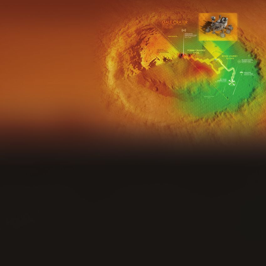
About BAE Systems Inc. Geospatial Intelligence (GEOINT) is intelligence about the human activity on earth derived from the exploitation and analysis of imagery and
geospatial information that describes, assesses, and visually depicts physical features and geographically referenced activities.
Welcome to BAE Systems Inc., a global defense, aerospace, and security company with more than 85,000 employees and almost $12B
in revenue worldwide. We deliver a full range of products and services for air, land, and naval forces, as well as advanced electronics, At BAE Systems GXP, you’ll collaborate with industry-leading business
security, information technology solutions, and customer support services. development personnel and software engineers, as well as cutting edge
technology, to make a real impact on the world around you.
Geospatial eXploitation Products™ (GXP™)
Supporting development of advanced geospatial intelligence, BAE Systems GXP software enables rapid discovery, analysis, and
sharing of mission-critical geospatial data. From key military, security, and incident response operations, to a variety of commercial
development and research initiatives, GXP provides a comprehensive suite of solutions to inform effective decision-making and
ensure a safer world.
GXP offices
San Diego, California
St. Louis, Missouri
Cambridge, United Kingdom
Rome, New York
Reston, Virginia
Denver, Colorado Kuala Lumpur, Malaysia
Durham, North Carolina
Tampa, Florida
GXP software solutions in the field
Canberra, Australia
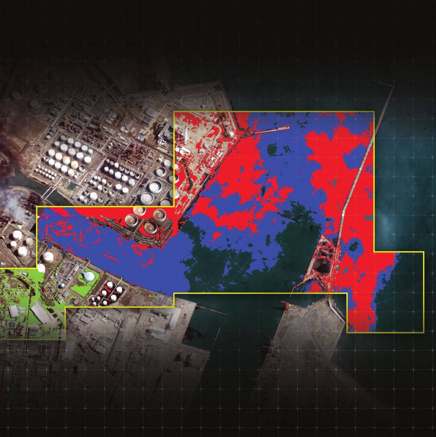
In 2011, a 9.0 magnitude earthquake occurred 231 miles northeast of Tokyo, causing a tsunami with 30’ waves that devastated the
█ Headquarters nation of Japan, including severe damage to several nuclear reactors and oil refineries. Through multispectral analysis, SOCET GXP®
█ Offices was used to identify and monitor the increasing footprint of resulting oil leakage into the Pacific Ocean. The extent and location of
█ Training centers
the oil and additional debris was monitored over time to assist in local relief efforts, determine environmental impact, and expose
potential navigational hazards - protecting life both above and below the surface of the water.
Multispectral, 8-band, WorldView-2 images. © 2021 Maxar Technologies.
GXP software solutions in the field
GXP software ecosystem                                                                                                               Supporting geological research on Mars, GXP
As a member of our team, you will be developing some of the most advanced geospatial intelligence software solutions in the          sensor models and software solutions enabled
world! From rapid data search and discovery, to advanced image exploitation and video analytics, the capabilities delivered          terrain analysis and efficient routing of the
through the GXP software ecosystem enable key decisions and mission success.                                                         Mars Curiosity rover. Through exploitation
                                                                                                                                     of satellite imagery, SOCET GXP capabilities
                                                                                                                                     were leveraged to calculate ground slopes and
                                                                                                                                     identify obstacles in order to determine optimal
                                                                                                                                     rover landing sites and navigation to areas of
                                                                                                                                     interest. Additionally, line-of-sight calculations
                                                                                                                                     helped determine unobstructed vantage points
                                                                                                                                     for clear communication of data back to Earth,
                                                                                                                                     ensuring a wide spectrum of scientific discovery
                                                                                                                                     beyond our native world.
               SOCET GXP                                  GXP Xplorer®                              GXP InMotion™
    Advanced geospatial exploitation            A revolutionary data management           A streamlined user experience designed
        and customized product                application that makes it easy to rapidly   for every level of video analysts’ needs
                                                                                                                                     As a GXP team member, you will continue to evolve a wide variety of industry
      creation combined into one               locate, retrieve, and share geospatial        - from simple viewing and editing
        comprehensive solution                  data files while paving the way for         to advanced tracking analytics and
                                                                                                                                     leading geospatial exploitation capabilities, including:
                                                 advanced geospatial exploitation            interpretation of motion imagery

                                                                                                                                                Automatic feature extraction                Image orthorectification

                                                                                                                                                Terrain analysis and editing                Automated terrain extraction

                                                                                                                                                3-D modeling                                Annotation and feature creation

             GXP WebView®                                 GXP Fusion™                                GXP OpsView®                               Synthetic Aperture Radar (SAR) processing   Multispectral and hyperspectral analysis
      Lightweight web browser-based               Integrating information from            Ensuring safety and security through a
  Electronic Light Table (ELT) that enables     disparate data sources to answer          Common Operating Picture (COP) for
                                                                                                                                                Tracking analytics                          LiDAR visualization and exploitation
     rapid visualization and analysis of       complex intelligent questions while              operational planning and
  geospatial data, and the development          developing a multi-INT Common                       incident response
          of actionable intelligence                   Intelligence Picture
                                                                                                                                                Video exploitation                          Precision targeting
GXP software solutions support image, video, and all-source analysts at defense and              The work we do matters
intelligence agencies, as well as commercial organizations, around the world including:
                                                                                                 We seek intelligent, dedicated, and passionate people who enjoy solving complex problems through innovative software
                                                                                                 solutions that provide our customers with an essential mission advantage. Successful team members will contribute to, and
                                                                                                 gain additional proficiency in, a variety of skill sets across desktop, server, and web software development; including cloud
                                                                                                 computing, advanced data analytics, machine learning and data science, and interactive data visualizations.

        Defense forces,                 Private security     Photogrammetry,      Universities   Featuring a distinct culture within the larger BAE Systems organization, the GXP group emphasizes rapid innovation, functional
  intelligence agencies, and          and first responder     mapping, and       and research    collaboration, and continual learning. Our strong work ethic and dedicated project focus is balanced with a wide variety of team-
      homeland security                    personnel        surveying agencies   organizations   building activities and social engagements from escape room and baseball game outings, to our annual Corporate Olympics. As a
                                                                                                 member of the GXP team, your voice will be heard and highly valued, and your efforts will be critical to the continued success of
                                                                                                 our products in the market.

                                                                                                 At GXP, the work you do is important–to us and the world. We offer:
         State, local,                  Transportation       Natural resource       Systems
                                                                                                 »   Flexible Schedules
        and regional                     departments          management          Integrators
                                                                                                     Flexible start times and a 9/80 work schedule
        governments                                            consultants

                                                                                                 »   Education/Development
                                                                                                     Tuition reimbursement, leadership programs, and mobility within the company
GXP software solutions in the field
                                                                                                 »   Leave Options
With an immense amount of traffic                                                                    A variety of leave options for individual flexibility, including personal time, military leave, and paid parental leave
moving through our cities, the continual
identification and tracking of “movers of                                                        »   Retirement Savings
interest” poses a significant challenge.                                                             401(k) plans with a generous company match, a wide range of investment options, and professional investing advice
Supporting a variety of missions including
counter-terrorism and drug enforcement,                                                          »   Health Benefits
GXP Movement Intelligence (MOVINT)                                                                   Numerous medical, dental, and life insurance plan options are available
solutions are used to automatically
monitor and index the movement of all                                                            We are committed to hiring and retaining a diverse workforce. We are proud to be an Equal Opportunity Employer, making
vehicles in a region. Eliminating the need                                                       decisions without regard to race, color, religion, sex, sexual orientation, gender identity, gender expression, marital status, national
for time-consuming manual observation                                                            origin, age, veteran status, disability, or any other protected class.
of motion imagery, GXP solutions enable
rapid discovery of anomalies, trends,
and emerging threats often concealed in
normal patterns of life.
More information on BAE Systems and GXP products:

Americas                                                                Asia
Toll free: 800 316 9643                                                 Telephone +603 2191 3000
gxpsales@baesystems.com                                                 gxpsales.asia@baesystems.com

Australia and New Zealand                                               Europe, Middle East, and Africa
Telephone +61 2 6160 4000                                               Telephone +44 1223 370 022
gxpsales.apac@baesystems.com                                            gxpsales.emea@baesystems.com

For additional contact information and worldwide distributors, please visit our website:
www.baesystems.com/gxp

© 2021 BAE Systems. All Rights Reserved. Geospatial eXploitation Products, GXP, GXP Fusion, GXP InMotion, GXP OpsView, GXP WebView, GXP Xplorer, and SOCET GXP are registered trademarks of
BAE Systems. This document gives only a general description of the product(s) or service(s) offered by BAE Systems. From time to time, changes may be made in the products or conditions of supply.
Approved for public release as of 06/14/2021. This document consists of general information that is not defined as controlled technical data under ITAR Part 120.10 or EAR Part 772. 20210526-13.


You can also read