Geoproduct potential analysis based on the example of the GEOsfera Ecological and Geological Education Center in Jaworzno
←
→
Page content transcription
If your browser does not render page correctly, please read the page content below
Geotourism vol. 16, 3‒4 (58‒59) 2019                                                  DOI: https://doi.org/10.7494/geotour.2019.58-59.28

Geoproduct potential analysis based on the example of
the GEOsfera Ecological and Geological Education Center
in Jaworzno
Analiza potencjału geoproduktu
na przykładzie Ośrodka Edukacji Ekologiczno-Geologicznej GEOsfera w Jaworznie

Barbara Bieniek1,2,a, Alina Kordysh1,2,b, Mateusz Mirosławski1,2,c,
Katarzyna Nowak1,3,d, Kacper Sękowski1,2,e, Edyta Sierka1,3,f,*
1
  College of Individual Interdisciplinary Studies of the University of Silesia in Katowice, Bankowa 12, 40-007 Katowice
2
  Faculty of Social Sciences, Bankowa 11, 40-007 Katowice
3
  Faculty of Natural Sciences, Będzińska 60, 41-205 Sosnowiec; Jagiellońska 28, 40-032 Katowice
e-mails: abasiabieniek@poczta.fm; balina6521@gmail.com; cmmiroslawski@hotmail.com; dkatarzyna009b@interia.pl;
e
 kaspian313@gmail.com; fedyta.sierka@us.edu.pl

*Corresponding Author

                                                                     Article history:
                                                                     Received: 28 September 2020
                                                                     Accepted: 12 December 2020
                                                                     Available online: 17 February 2021

                                                                     © 2019 Authors. This is an open access publication, which can be
                                                                     used, distributed and reproduced in any medium according to the
                                                                     Creative Commons CC-BY 4.0 License requiring that the original
                                                                     work has been properly cited.

Abstract: At the time of discovering and exposing the scientific and educational potential of areas where mineral resources were exploited
in the past, they have become a significant element in tourism elements. In the presented paper, the potential of the GEOsfera Ecological
and Geological Education Centre in Jaworzno as a geoproduct was analysed. In the first part of the study, based on the published works
and consultations with experts, the “geoproduct” was defined. Then the area, where the GEOsphere is located, was characterized. Its ge-
ology, the natural world, the way of land development and the promotion of geo-attractions located in this area are described. In the next
stage, an analysis of the opinions of users regarding their perception of the GEOsphere was carried out. For this purpose, evaluations post-
ed on social media and the collected survey results were used. As shown by the results, the majority of users of the GEOsfera are residents
of Jaworzno – 63% of the respondents. The importance of the GEOsphere as an educational centre was indicated by 22% of visitors. About
5% of the respondents mentioned learning and obtaining information from the descriptions placed next to the exhibits in the centre. 93% of
respondents recognised the graduation tower as the greatest attraction of the GEOsphere. Over 92% of people noticed the recreational role
of the GEOsphere. 81% of users declared that they were satisfied with their visit to the GEOsphere. More than half of the respondents (56%)
visited the GEOsfera with their family. A significant part of respondents (42%), pointed to the role of environmental protection, which is
extremely important from the point of view of geoproducts’ design. The respondents also indicated that the GEOsphere has numerous geo-
logical, natural and educational functions and protects and promotes the geological heritage of the region.

Keywords: geo-attractions, geological education, natural potential, limestone quarry, Jaworznickie Hills

Treść: W dobie odkrywania i eksponowania potencjału naukowego i edukacyjnego terenów, na których w przeszłości prowadzono eksploa-
tację surowców, stają się one znaczącymi obiektami turystycznymi. W prezentowanej pracy dokonano analizy potencjału Centrum Edukacji
Ekologiczno-Geologicznej GEOsfera w Jaworznie, zlokalizowanego na terenie wyrobiska surowców skalnych, jako geoproduktu. W pierw-
szej części opracowania, opierając się na dostępnych pracach publikowanych i konsultacjach z ekspertami, zdefiniowano „geoprodukt”
oraz określono kryteria, jakie powinien spełniać. Następnie opisano teren, na którym zlokalizowana jest GEOsfera, uwzględniając geo-
logię, elementy przyrody ożywionej oraz sposób zagospodarowania terenu i promowania geoatrakcji, które się tam znajdują. Na kolej-
nym etapie przeprowadzono analizę opinii użytkowników w zakresie postrzegania przez nich GEOsfery. Do tego celu wykorzystano oceny

https://journals.agh.edu.pl/geotour                                                                   eISSN 2353-3641 | ISSN 1731-0830
                                                                    29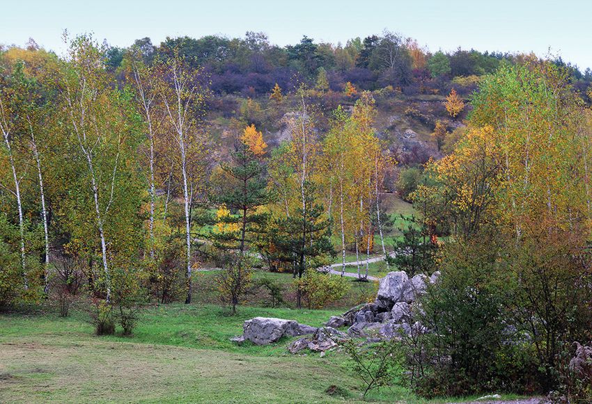
Barbara Bieniek, Alina Kordysh, Mateusz Mirosławski, Katarzyna Nowak, Kacper Sękowski, Edyta Sierka
zamieszczone w mediach społecznościowych i zgromadzone wyniki badań ankietowych. Wykazały one, że większość spośród badanych
użytkowników GEOsfery to mieszkańcy Jaworzna, którzy stanowili 63% ankietowanych. Znaczenie GEOsfery jako istotnego ośrodka edu-
kacyjnego wskazało 22% odwiedzających. Około 5% pytanych doceniło uczenie się i pozyskiwanie informacji z opisów umieszczonych na
tablicach obok eksponatów na terenie ośrodka. Jako największą atrakcję terenu GEOsfery 93% ankietowanych wskazało tężnię solankową.
Ponad 92% respondentów dostrzegło rekreacyjną rolę GEOsfery i dogodne warunki do aktywnego spędzania czasu. 81% badanych zade-
klarowało zadowolenie z wizyty. Ponad połowa respondentów (56%) odwiedziła GEOsferę z rodziną. Znaczna część ankietowanych (42%)
zwróciła uwagę na znaczenie ochrony środowiska w funkcjonowaniu GEOsfery, co jest niezwykle ważną informacją przydatną podczas
projektowania geoproduktu. Użytkownicy, którzy wzięli udział w badaniu, wskazali również, że GEOsfera ma liczne walory geologiczne,
przyrodnicze i edukacyjne oraz chroni i promuje dziedzictwo geologiczne regionu.
Słowa kluczowe: geoatrakcje, edukacja geologiczna, potencjał przyrodniczy, kamieniołom wapieni triasowych, Pagóry Jaworznickie
Introduction area. It should be an educational tool, as well as a commer-
cial product. In accordance with the idea of sustainable de-
More and more often, areas where the extraction of raw velopment, a geoproduct must be environmentally friendly
rock materials has ended are used as tourist attractions, com- and should combine local traditions with scientific elements.
bining education with leisure (Woźniak et al., 2011). The Sa- Dryglas & Miśkiewicz (2014) proposed the classifica-
dowa Góra quarry in Jaworzno is a good example of such tion of geoproducts. The basic groups of geoproducts in-
a transformation, where environmental potential has been clude:
adapted for the purpose of education, mainly in geology, but • objects, e.g. geotouristic guides, handicrafts (geo-cos-
also in the field of biological sciences. Post-mining areas, of- metics, geo-jewellery);
ten with a significant potential of preserved natural qualities • locations, e.g. mining facilities, lapidary workshops;
(fossils, geological formations, etc.), as a result of human • events, e.g. mineral exchanges, geological picnics,
industrial activity, can be used to create facilities, which are geo-conferences;
attractive for tourists and are able to function as commercial • services, e.g. geo-educational, geo-sales, geo-medical
entities. (lithotherapy).
The aim of this study is to analyse the tourism potential
of the quarry area turned into Centre for Ecological and Geo- In addition, complex geoproducts such as:
logical Education – GEOsfera, as a geoproduct. • events, e.g. field games (Geocaching);
What is a geoproduct? A geoproduct, according to Mi- • paths, e.g. educational paths;
chał Poros (2014), the director of the Kielce Geopark, is de- • areas, e.g. national and UNESCO geoparks, mineral
fined as a popularization tool for the product of Earth sci- springs.
ences. It is a post-exploitation area, an artefact of a past state
Based on the information above, a “geoproduct can be
or activity that connects all interested communities, the ac-
defined as any object, institution, or an event aimed at pro-
ademics, specialists, experts in the subject, and people in-
moting the geological heritage of a specific area, related to
volved in the dissemination of knowledge. A geoproduct
the concepts of earth sciences and life sciences, used for
is correlated with the goals of local governments focused
commercial and educational purposes, and inherently en-
on development and education. In terms of geology, it is
vironmentally friendly”. A geoproduct is directly related to
the uncovering of an important place in this respect, e.g.
geotourism focused on learning about geological facilities
a post-mining area, which must, however, be identifiable
and processes. Through direct contract, a geoproduct al-
with a tourism event promoted under a specific name. Con-
lows one to experience sensual and aesthetic impressions.
trary to the essence of the geoproduct, it does not have to
Geotourism utilises the results of basic geological research
be related to geology as such. It presupposes a greater con-
for practical purposes and is closely related to environmental
tribution from people and history rather than only from the
protection (Ścibisz-Kosanowska et al., 2013).
presence of nature in itself. Often, it refers only to historical
memory, being attached to a place that builds the identity of
the local community.
Study methods and characteristics of
According to the UNESCO definition (UNESCO
Geoparks Programme... 1999), “geoproducts are innov the research subject
ative artisanal products that are associated with geology”.
In the opinion of Farsani et al. (2012), a geoproduct should Material used in the analysis was collected from the
be made from locally sourced products, while being a sym- available expert studies and published papers. Results were
bol of the geological (or geomorphological) heritage of the obtained also from questionnaires prepared by the authors.
Geotourism vol. 16, 3‒4 (58‒59) 2019 https://journals.agh.edu.pl/geotour
30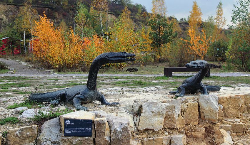
Geoproduct potential analysis based on the example of the GEOsfera Ecological and Geological Education Center in Jaworzno
The Centre for Ecological and Geological Education along with the Garb Ciężkowicki region is a part of the
GEOsfera in Jaworzono was adopted as the research subject. Jaworznickie Pagóry range. The region borders from the
GEOsfera is the facility with the total 8 ha of the land- East with a Pleistocene denudation plain, which is filled
scaped area, established on the site of a former dolomite with sands and gravels dating back to the Odra glaciation
quarry (Fig. 1). Located between Jaworzno city centre and (Tokarska-Guzik et al., 2012). The hills of Jaworznickie
the Sand Mountain, on premises Sadowa Góra. During the Pagóry are inliers. They consist of monoclinally arranged
Triassic Era, 230 million years ago, this area was occupied carbonate Triassic formations (Kurek et al., 1994). Sado-
by a shallow and warm sea, inhabited by a swimming pre- wa Góra is an old excavation site where mainly marly con-
historic lizard – the Nothosaurus. With time, some dead re- glomerates of the upper Gogolin Formation were excavated
mains of bivalves, brachiopods and echinoderms settled on (Nita & Bradziński, 2008 after: Woźniak & Krzeczyńska,
the seabed. 2014). The Gogolin Formation developed in the Triassic
and is divided into the lower (older) and the upper (young-
er). The lower Gogolin Formation consists of carbonate
rocks: limestones, conglomerates with a carbonate binder
and marls. In the lowest part of its profile, the Gogolin For-
mation consists of: micrite, fine-detritic, medium and thick-
bed limestones, containing numerous fragments of crinoids.
Their main species is Dadocrinus kunischi (Kurek et al.,
1994). Crinoids belong to the echinoderms family. Their
fully preserved frames, including the crown, are a rare find,
because usually the dead flower crumbles. You can find
many trochites at the GEOsfera (Woźniak & Krzeczyńs-
ka, 2014). They are single rings that build the daylily stem.
In their glory days, when they lived static lives, crinoids
formed so-called lily meadows. Abundant accumulations
of trochites are the building blocks of crinoid limestones.
Crinoids fragments are accompanied by numerous bivalves,
predominantly the Pecten discites, as well as Plagiostoma
striatum species. Marly limestones with a wavy roof and
bottom reside above the crinoid limestones. The lower part
of the Gogolin Formation consists of some open sea sedi-
ments, associated with the first transgression of this period.
Dark yellow dolomitic cellular limestones are at the bottom
Fig. 1. Localisation of the Centre for Ecological and Geological Ed- of the lower part of the Gogolin Formation. They are a relic
ucation GEOsfera in Jaworzono
of evaporites formed as a result of gradual regression of the
sea basin (Woźniak et al., 2010).
The upper part of the Gogolin Formation begins with con-
glomerate and intra-formation limestones, in which we can
Until 1980, limestones and dolomites were mined in this find pebbles of micrite and marly limestones from the low-
area for the needs of the cement industry. After the raw rock er layers of the formation. Crinoid limestone containing bi-
materials were exploited, attempts were made to cover the valves (Lima striata Goldfuss) is the binder here along with
quarry with waste. However, thanks to the involvement of fragments of reptile bones (Kurek et al., 1994). The highest
Jaworzno authorities and experts in the field of geology and part of the Gogolin Formation consists of micrite and sparite
zoology, who identified the natural, mainly geological po- limestones. This layer contains two levels with a wavy tex-
tential of the area, it was decided in 2014 that the GEOsfera ture – that is the 2nd and 3rd wavy limestone. The upper part
will be established in the quarry. Funds were obtained for of the Gogolin Formation displays a record of a sea trans-
this purpose from the European Regional Development Fund gression that caused the emergence of Tethys Ocean fauna
under the Regional Operational Programme of the Śląskie in the Germanic Basin (Woźniak et al., 2010). The thick-
Voivodeship for the years 2007 – 2013. The current GEO ness of the Gogolin Formation ranges from 25 to 30 meters.
sfera has an extensive infrastructure, i.e. a ripple marks ex- Above the Gogolin Formation, the Diplopora-bearing layers
hibition pavilion, reconstruction of Triassic vertebrate hab- can be found, followed by Tarnowice Beds, which end with
itats, a graduation tower, a “geological window” and an middle Muschelkalk limestones. The upper Muschelkalk
educational trail with information signs. limestones is composed of the Boruszowice Beds, which,
The Sadowa Góra quarry is located within the Garb just like the Tarnowice Beds, are made of micrite and oolite
Jaworznicki highland region (Kurek et al., 1994; Jochem- dolomites with sandstone interbedding (Kurek et al., 1994;
czyk et al., 2004; Tokarska-Guzik et al., 2012), which, Jochemczyk et al., 2004; Woźniak et al., 2010).
Geotourism vol. 16, 3‒4 (58‒59) 2019 https://journals.agh.edu.pl/geotour
31
Barbara Bieniek, Alina Kordysh, Mateusz Mirosławski, Katarzyna Nowak, Kacper Sękowski, Edyta Sierka
The Szczakowa Cement Plant ended production in Jaworz The above-mentioned crinoids are examples of living
no in 1999. It was the chief recipient of raw rock materials, fossils, but only those species that have retained the stem
so mining stopped as well and excavation site walls were left are present.
exposed. One can clearly observe the sequence of rock layers The area of the centre in question can boast of a unique
of the Gogolin Formation in the profile of the quarry walls. wealth of Triassic rocks, but also a stunning display of ani-
Beginning with crinoid limestone, 1st wavy limestone oc- mated nature, i.e. flora and fauna, for which the quarry has
cur, then intra- to the formation conglomerate and 2nd wavy provided favourable conditions for development. The walls
limestone occur finally (Markowiak, 2014). In the rocks, of the excavation are cliffs and there are numerous depres-
we can find numerous fossils, ichnofossils, including the sions and elevations at the bottom. The soil variations are at
aforementioned crinoid trochites. The wall of the GEOsfera the stage of initial rendzinas with varying levels of humus,
quarry is a record of the Germanic Sea that filled this area carbonate rocks and moisture.
225–210 million years ago. It was an epicontinental sea (with Diverse habitat conditions allowed for the formation of
a maximum depth of 100 meters, 50–60 m in today’s Jaworz a mosaic of plant communities in this area, from places cov-
no city limits), well oxygenated, in which predatory reptiles ered with vegetation consisting of forests in initial stages of
thrived. Reptiles are represented at GEOsfera by the fish-eat- development, through shrubs, grasslands and meadows to
ing Nothosaurus, which is classified as a primitive fin-liz- typically ruderal areas (Fig. 3). In the quarry itself and in
ard (Markowiak, 2014). The length of their bodies could its immediate vicinity, 433 species of vascular plants were
exceed four meters (Surmik, 2013). Apart from the “false found (Szendera et al., 2016). Characteristic elements of this
lizard”, the ichthyosaurs and posterodontons also probably area are thickets of shrubs including blackthorn (Prunus spi-
lived at Sadowa Góra (Woźniak & Krzeczyńska, 2014). The nosa), European buckthorn (Rhamnus cathartica) and sin-
GEOsfera Jaworzno can boast of the presence of mega rip- gle-necked hawthorn (Crataegus monogyna). Undergrowth
plemarks on its grounds (Fig. 2). These are numerous, regu- and small biogroups of trees are mainly composed of Scots
lar furrows separated by gutters. These wrinkles flow in the pine (Pinus sylvestris) and warty birch trees (Betula pendu-
North-South direction. Their size and amplitude (10–35 cm) la), species that disseminate thanks to the wind. Slopes with
suggest that they are the result of oscillatory waves in the sliding layers of weathered limestone are covered mainly
declining phase of tropical hurricanes (Markowiak, 2014; with species of blackberry (Rubus sp.), but also with sponta-
Woźniak & Krzeczyńska, 2014). In geology, objects of this neous growth of light-seeded trees such as Scots pine, silver
type are used to reconstruct palaeoenvironments. birch and willow trees.
Fig. 2. Mega ripplemarks. Photo E. Sierka
Geotourism vol. 16, 3‒4 (58‒59) 2019 https://journals.agh.edu.pl/geotour
32
Geoproduct potential analysis based on the example of the GEOsfera Ecological and Geological Education Center in Jaworzno

Fig. 3. Quarry walls with spontaneously encroaching vegetation. Photo E. Sierka

    Xerothermic grasslands are an inextricable element of              “BioGalmany” project, the calamine plants area was created
limestone areas at GEOsfera. These thermophilic commu-                 with plant species associated with this very specific habitat.
nities consist of the Carthusian pink (Dianthus carthusiano-           The area also includes sensory gardens that can be perceived
rum), the spiny restharrow (Ononis spinosa), and many                  with all senses, i.e. sight, smell, touch, hearing and taste.
others. In places where the terrain is almost flat, sandy                  The resulting wealth of plant species also indicates the
grasslands develop fragmentarily on the sandy ground. At               diversity of other organisms. The GEOsfera faunal inventory
GEOsfera, these communities are mainly formed by dicot-                (Inwentaryzacja przyrodnicza... 2017) showed the presence
yledonous plants, i.e. sand thyme (Thymus serpyllum), sea              of 282 different species of animals from the groups: anne-
thrift (Armeria maritima), and field chickweed (Cerastium              lids (1), molluscs (10), crustaceans (2), trichomonads (13),
arvense). Meadow communities also develop spontaneously                insects (165), centipedes (3), amphibians (7), reptiles (4),
in moderately humid places. Where the permeability of the              birds (60), mammals (17). The quarry itself is a natural ter-
substrate is lower, e.g. at ripple marks or depressions, tempo-        rain ‘trap’ for smaller fauna specimens living in its vicinity,
rary stagnant water gathers, thus eliminating species that do          integrated into the local landscape. Some animals move to
not prefer stagnant water.                                             the GEOsfera area or its vicinity, while others are blown over
    Simultaneously vegetation from adjacent areas appears in           from neighbouring biotopes, open areas and forests, as well
the fissures where rocks are weathering. On the grounds of             as the surrounding Pagóry Jaworznickie hills covered with
the Centre for Ecological and Geological Education, many               diverse plant systems. In addition, the semi-open quarry area
habitats have been established by man. These include a water           is located on the route of local animals migrating between
reservoir with rush vegetation consisting of lakeshore bul-            various types of biotopes, from near and far in the vicinity,
rush (Schoenoplectus lacustris), the European water-plantain           including larger forest complexes (Inwentaryzacja przyrod-
(Alisma plantago-aquatica), and the broadleaf cattail (Ty-             nicza... 2017). Numerous species of butterflies are associated
pha latifolia), as well as submerged vegetation including the          with limestone areas, such as the chalkhill blue (Polyomma-
spiked water-milfoil (Myriophylum spicatum). As part of the            tus coridon).

Geotourism vol. 16, 3‒4 (58‒59) 2019                                                                 https://journals.agh.edu.pl/geotour
                                                                  33
Barbara Bieniek, Alina Kordysh, Mateusz Mirosławski, Katarzyna Nowak, Kacper Sękowski, Edyta Sierka
A vertebrate species associated with wetland habitats is Results
e.g. the European tree frog (Hyla arborea). This species leads
a land-water lifestyle. It can climb trees and begins its activ- The GEOsfera is present in social media via Facebook
ity only at dusk. There are also animals only temporarily liv- and Trip Advisor. Since the creation of the profile in 2014,
ing at the GEOsfera, e.g. using the quarry area as an ecolog- 9161 people have liked the GEOsfera page on Facebook,
ical corridor in their migration. Within the OEEG GEOsfera, which is a moderate result when you consider that the GEO
one can find the Field Research Station of the University of sfera has about 10,000 visitors annually. Announcements
Silesia in Katowice – BIOGEO, where students learn about about site modernisation, educational events, etc. are pub-
the diversity of life forms in this area. lished via Facebook. The popularity of posts published for two
Closed quarries are experiencing a renaissance nowa- months (May–June 2019) ranged from 5 to 322 likes per post.
days, often adapted for recreational purposes and events for The average rating of the facility, out of 200 opinions
minerals and fossils enthusiasts. As a result, geotourism is on expressed on Facebook, is 4.7 on a five-point scale. In addi-
the rise, encouraging tourists to explore in depth the regions tion, 60 people posted comments to GEOsfera, in which they
they visit and offering them an opportunity to learn about the indicated the following advantages of the facility presenting
natural history of our planet. The GEOsfera in Jaworzno is in Fig. 4.
a good example of an attractive geotourism site (Chybiorz
& Kowalska, 2017). The main idea behind the creation of
GEOsfera is the large-scale promotion of the riches of the
2.7
natural world. In the extensive sensory park created here, one 5.3
can see over forty thousand plants. It is a place where, apart
6.0
from recreation and tourism, the educational offer reaches
far beyond the limits of academic theory. The main concepts 39.0
behind the establishment of the Centre focus on the inextri- 9.7
cable bond between all elements of the natural environment,
as well as on showing the constant changes in the plant and
animal world. One of the main goals of the Centre is nature
education, based on acquiring knowledge and skills through
experience and shaping desirable environmental attitudes.
Installations at GEOsfera with an especially large po-
tential in terms of geotourism include, among others, recon-
structions of the Triassic four-legged land animals. At GEO 37.3
sfera a small pavilion was built for the purpose of showcasing
ripple marks, which were most probably created as a result
of a gigantic tsunami caused by an earthquake. Right next to
the pavilion, there are mega ripplemarks, i.e. huge fossilized
wave marks (Fig. 3). The geological history information has
been placed on educational billboards and is presented at nu-
merous exhibitions that bring the history of the Triassic pe-
riod to life. In addition, currently the centre organizes nearly
thirty different thematic activities available for free to groups Fig. 4. Opinions evaluating GEOsfera park in Jaworzno on basis of
of tourists. Facebook portal
In addition to being an educational space, the GEOsfera
also offers recreational facilities. Walking routes, view-
points, a graduation tower, a barbecue site, a small amphi-
theatre, a playground, a didactic room, a pond, a seasonal The centre in Jaworzno also has a profile on Trip Advisor,
clock, a weather station, a moorland and a sensory garden where the average rating from 31 user ratings is 4/5. Written
are all located on an area of 20 acres. opinions were expressed by 26 users, in which they indicated
Admission to the premises is free, and lighting available the following advantages of the facility in Figure 5.
24 hours allows guests to visit without time restraints. The Opinions expressed by internet users show that GEOsfera
direct safety measures at the facility include a video surveil- is primarily perceived as a place for relaxation, where you
lance system. There is a small car park for guests arriving by can go for walks with children. On Facebook, only a small
car. Public transport to and from the city centre is also avail- (6.7%) group of visitors mentioned the educational or nat-
able. The GEOsfera is a place for those who are interested in ural value of the facility. Almost a quarter of commenting
history and excavations, as well as for those who seek peace users (23%) emphasized the value of these elements on Trip
and relaxation, which is extremely important in the densely Advisor, but still most (65%) visitors considered the GEO
populated Silesian conurbation. sfera primarily as a good place to visit with children.
Geotourism vol. 16, 3‒4 (58‒59) 2019 https://journals.agh.edu.pl/geotour
34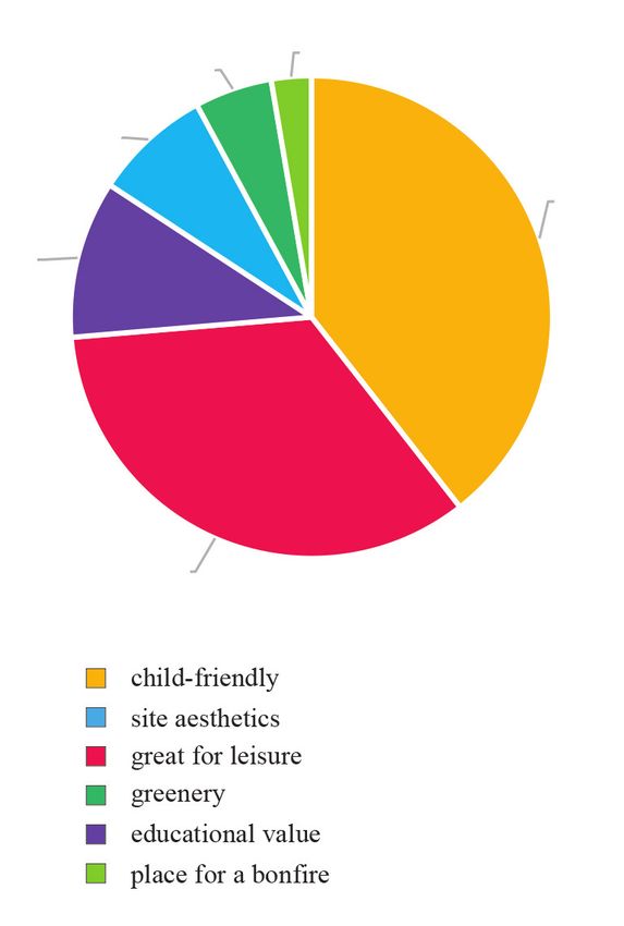
Geoproduct potential analysis based on the example of the GEOsfera Ecological and Geological Education Center in Jaworzno
6.7
2.8 of people also mentioned learning and obtaining in-
formation from descriptions next to the exhibits, and
2% of people indicated cycling.
15.1 • The brine graduation tower was considered the most
attractive facility at the GEOsfera (as many as 93% of
45.2
respondents considered this facility as exceptionally
attractive). The sensory garden was second (45%). In
turn, 33% of people found the dinosaur reconstructions
very appealing, 23% mentioned the bonfire place, and
15.1 only 15% came to visit to see the calamine plants. The
playground was mentioned in a few answers.
• Almost half, i.e. 44% of the respondents, declared that
they spent 31-60 minutes at the GEOsfera, while 25%
15.1 spent 61–120 minutes, 23% spent over two hours, and
only 8% spent no more than 30 minutes at GEOsfera.
• Over 92% of respondents recognise the recreational
role of the GEOsfera, which is in line with the most
frequently declared purpose of visits to the GEOsfera
– walking and leisure. Interestingly, the educational
role was in second place (81%), although only 22% of
respondents declared education as the purpose of their
Fig. 5. Opinions evaluating GEOsfera park in Jaworzno on basis of visit. This points to the fact that the educational role
Trip Advisor portal of the GEOsfera is widely recognised, but it can be
better utilised to build the potential of the GEOsfera
as geoproduct. As many as 71% of respondents be-
A poll consisting of 13 questions in a questionnaire was lieve that the GEOsfera effectively promotes the re-
conducted on a sample of 100 people (61 women, 39 men) at gion, and 42% see its contribution to environmental
the centre. The results show that: protection. The health role was also emphasised, i.e.
supporting the healing process for patients (2%).
• Most respondents (63%) were residents of the city Ja-
• 81% of respondents declared they were satisfied with
worzno. Of the remaining 37%, four people declared
their visit to GEOsfera, 15% were not fully satisfied,
that they live in the countryside.
and 4% were undecided on the matter.
• Most of GEOsfera visitors found out about it from
• In the surveyed group, 37% of respondents believe
friends (53%) or learned about it on the Internet
GEOsfera could benefit from a number of improve-
(26%). Only 5% of visitors found information about
ments, and the suggestions were as follows: four peo-
the GEOsfera in the press. This observation most
ple pointed to the lack of places to eat, two people did
probably indicates that the GEOsfera is not present
not like the gravel paths, two visitors indicated the need
nearly enough in either traditional or social media.
to take better care of the vegetation, and another two
Only 8% of respondents came upon the facility while
recommended building a fountain. Some expressed the
driving or walking by, and 2% of the respondents
need for more activities for children, including multi-
found out about it from regional television.
media. Some pointed out that the area could be cleaner
• The most frequently declared purpose of visiting the
or that the dinosaur models could be bigger.
GEOsfera was taking a walk in the open air (71% of
• More than half of the respondents (56%) visited the
respondents). The second most frequent purpose of
GEOsfera with their families, 26% came with friends,
a visit to GEOsfera was leisure (55%), and the third –
and 16% with a partner. 5% visited the GEOsfera on
providing children with something engaging and fun
a school trip, and 4% came alone. The results show that
(30%). Education was mentioned by only 22% of vis-
the GEOsfera is a family establishment. This is import-
itors. Only 2% of people declared taking advantage
ant in the context of possible changes that may be intro-
of the graduation tower as the purpose of their visit.
duced (e.g. making it more attractive to children).
At the very bottom of the list, 1% of visitors indicated
their professional duties as a reason to visit, tied with In general, the GEOsfera is viewed positively by visi-
“curiosity”, also at 1%. tors. However, knowledge about the GEOsfera is distributed
• In response to an open-ended question about activ- mainly through word of mouth, less so through the media.
ities undertaken in the park, 90% of people men- This indicates the need for better publicity at the centre. Some
tioned walking, 21% inhalation, 5% viewing the ob- aspects of the GEOsfera, when defined as a geoproduct, are
jects (especially dinosaur reconstructions). Only 5% noticed and perceived as important by visitors, especially
Geotourism vol. 16, 3‒4 (58‒59) 2019 https://journals.agh.edu.pl/geotour
35Barbara Bieniek, Alina Kordysh, Mateusz Mirosławski, Katarzyna Nowak, Kacper Sękowski, Edyta Sierka
its educational role. Several hypotheses can be made about • promotional activities provide publicity for the region
this state of affairs. One of them is the low appeal of edu- and its heritage;
cational objects, which was indicated by respondents in the • exhibitions, events and educational trails at the GEO-
open question. A significant number of respondents (42%) sfera fulfil its educational role;
noticed the environmental protection role, which is extreme- • thanks to its aesthetic merits and facilities such as
ly important from the point of view designing a geoproduct. the graduation tower, the GEOsfera is developing its
Perhaps the environmental role was not emphasised strong- commercial and geotouristic potential;
ly enough by the exhibits and their descriptions in the park. • the growing number of visitors (only 40% are not resi-
A facility of great importance for the GEOsfera is the brine dents of Jaworzno) proves the need for such facilities;
graduation tower, which draws visitors who are not interest- • the commercial aspect resulting from the definition
ed in geology, nature or the educational offer of the Centre, of a geoproduct is not fully realised at the GEOsfera.
but in improving their health. Rather it relies on the durability of the project, as part
GEOsfera as a geoproduct. In light of the definition of of which the GEOsfera was created.
a geoproducts proposed by Dryglas & Miśkiewicz (2014),
the GEOsfera in Jaworzno offers its visitors numerous
geo-attractions, which are geoproducts. The facility hosts Recommendations and summary
mineral exchanges that fall under the “events” category.
There are also “facilities” on the site: a lapidarium, a gradua- The GEOsfera Ecological and Geological Education
tion tower, a sensory garden and reconstructed mining facili- Centre in Jaworzno meets the criteria of a geoproduct, mean-
ties. It is important to remember that the Centre itself used to ing that it fulfills both the aesthetic and didactic expectations
be a mining facility. In the “services” category, geoeducation and is of value to the citizens of Jaworzno and tourists.
is at the top of the list. Moreover, the GEOsfera offers more However, in order to strengthen its rank, it is worth con-
complex geoproducts: recreational games such as Geocach- sidering:
ing and educational trails. • increasing the number and visibility of signs indicat-
After analysing the GEOsfera Centre in terms of the defi- ing the location of the GEOsfera;
nition of a geoproduct adopted for the purposes of this work, • taking into account the presence of disabled people –
it was established that the GEOsfera fulfils all the require- e.g. modifying fragments of gravel paths that make it
ments to be categorized as such. This is achieved thanks to: difficult to move around on bikes or wheelchairs;
• the development of the area for the purposes of tour- • better display of fossils and Nothosaurus models
ism and education protecting the geological heritage (Fig. 6), whose information boards should be larger and
of the region; in a more visible places.
Fig. 6. Nothosaurus models at GEOsfera. Photo E. Sierka
Geotourism vol. 16, 3‒4 (58‒59) 2019 https://journals.agh.edu.pl/geotour
36Geoproduct potential analysis based on the example of the GEOsfera Ecological and Geological Education Center in Jaworzno
The centre, despite the huge local and even national po- formations. It is also a very important area for the integration
tential (as evidenced by the top award of the Ministry of the of Jaworzno residents.
Environment “Geology 2018”) and the multiple elements
that emerged during and after its exploitation, does not meet
the criteria of being a geopark. The Jaworzno facility ra Acknowledgments
ther fits into the idea of geosites (Chybiorz et al., 2015) and
is included in the Central Register of Geosites run by the The authors of this paper would like to thank:
PGI-NRI (Polish Geological Institute – National Research Mrs. Agnieszka Chećko, director of the Centre for Eco-
Institute). logical and Geological Education GEOsfera in Jaworzno,
The GEOsfera as a cultural and ecological institution and Mr. Paweł Woźniak from PGI-NRI Sosnowiec Branch,
appears to be a well-run project, created thanks to peo- for consultations and substantive support.
ple involved in strengthening the tourist appeal of the lo- The project was realised as a part of the module for find-
cal natural environment. A product has been created that is ing solutions to heterogeneous problems and was financed
a family-friendly, allowing for better contact with nature, sur- by the College of Individual Interdisciplinary Studies of the
rounded by the remains of a historic quarry with geological University of Silesia in Katowice in 2019.
References & Krzeczyńska M., 2014. Kamieniołom Sadowa Góra w Jaworz-
nie – przyszłość pod znakiem GEOsfery!. Przegląd Geologiczny,
62(10/1): 510–513.
Chybiorz R. & Kowalska M., 2017. Inwentaryzacja i ocena atrakcyj- Poros M., 2014. Georóżnorodność w architekturze – wykorzystanie lo-
ności geostanowisk województwa śląskiego. Przegląd Geologiczny, kalnych surowców skalnych w architekturze użytkowej na obszarze
65(6): 365–374. istniejących i projektowanych geoparków europejskich. Przegląd
Chybiorz R., Babczyńska-Sendek B., Rostański A., Gorczyca J., Pa- Geologiczny, 62(3): 151–155.
sierbiński A., Fojcik B., Nowak T., Bzdęga K., Woźniak G., Strze- Surmik D., 2013. Triasowe gady morskie w Polsce. In: Machalski M.
lec M., Krodkiewska M., Bula R., Urbisz A., Sierka E., Jędrzejczyk- (red.), Rocznik Muzeum Ewolucji Instytutu Paleobiologii PAN,
-Korycińska M., Błońska A., Bardziński W., Kurowska E., Nita J., 5: 9–16.
Waga J.M., Orczewska A. & Tokarska-Guzik B., 2015. Dane o róż- Szendera W., 2016. Inwentaryzacja przyrodnicza terenu kamieniołomu
norodności biologicznej i georóżnorodności – Geostanowiska. In: Sadowa Góra w Jaworznie, 79 [unpublished].
Tokarska-Guzik B., Chybiorz R. & Parusel J.B. (red.), Baza danych Ścibisz-Kosanowska M., Kowalska M. & Szrek P., 2013. Geotury-
przestrzennych w zarządzaniu zasobami środowiska przyrodniczego styka w regionach turystycznych Polski południowo-wschodniej –
województwa śląskiego. Uniwersytet Śląski w Katowicach: 108–114. przystosowanie obiektów geoturystycznych na potrzeby turystyki
Dryglas D. & Miśkiewicz K., 2014. Construction of the geotourism zrównoważonej. Zeszyty Naukowe Turystyka i Rekreacja, 11(1):
product structure on the example of Poland. In: 14th GeoConference 67–82.
on Ecology, Economics, Education and Legislation. International Tokarska-Guzik B., Rostański A., Gorczyca J., Herczek A. & Dulias R.,
Multidisciplinary Scientific Geoconferences, 5(2): 155–162. 2012. Waloryzacja przyrodnicza miasta Jaworzna, Zakład Badaw-
Farsani N.T., Coelho C., Costa C. & Neto de Carvalho C. (eds.), 2012. czo-Usługowy “EKOS”. https://www.um.jaworzno.pl/pl/natura/
Geoparks & Geotourism – new approaches to sustainability for the przyroda_i_ekologia/39/waloryzacja_przyrodnicza_miasta.html
21st Century. Brown Walker Press, Boca Raton. [accessed: 2020.10.27].
Inwentaryzacja przyrodnicza fauny Ośrodka Edukacji Ekologiczno- UNESCO Geoparks Programme: a new initiative to promote a glob-
-Geologicznej w Jaworznie, 2017. Envirex. Usługi Środowiskowe al network of geoparks safeguarding and developing selected ar-
i Edukacja [unpublished]. eas having significant geological features, 1999: 156 EX/11 REV.
Jochemczyk L., Krieger W., Lis J., Olszewska K., Pasieczna A., https://unesdoc.unesco.org/ark:/48223/pf0000115177 [accessed:
Preidl M., Strzemińska K., Wołkowicz S. & Strzelecki R., 2004. 2020.10.27].
Objaśnienia do mapy geośrodowiskowej Polski 1:50000, Arkusz Ja- Woźniak P. & Krzeczyńska M., 2014. Kamieniołom Sadowa Góra
worzno, Państwowy Instytut Geologiczny. w Jaworznie – przyszłość pod znakiem GEOsfery!. Przegląd Geo-
Kurek S., Paszkowski M. & Preidl M., 1994. Objaśnienia do szczegó- logiczny, 62(10/1): 510–513.
łowej mapy geologicznej Polski 1:50000, Arkusz Jaworzno (944), Woźniak P., Sikora R., Lasoń K., Markowiak M., Haisig J., Szulc J. & Hag
Państwowy Instytut Geologiczny. dorn H., 2010. Geopark Góra św. Anny – udokumentowanie i propo-
Markowiak M., 2014. Karta dokumentacyjna geostanowiska – 007390: zycja jego ochrony, PIG-PIB Oddział Górnośląski im. St. Doktoro-
„GEOsfera w Jaworznie”, Centralny Rejestr Geostanowisk Polski wicza-Hrebnickiego. https://www.pgi.gov.pl/docman-tree/oddzial-
PIG-PIB, http://geostanowiska.pgi.gov.pl. [accessed: 2020.10.27] gornoslaski/2071-gora-sw-anny-opracowanie/file.html [accessed:
Nita J., Bardziński W., 2008. Ogólna inwentaryzacja walorów geolo- 2020.10.27].
gicznych Kamieniołomu Sadowa Góra na terenie miasta Jaworz- Woźniak P., Sikora R., Lasoń K., Markowiak M., Haisig J., Szulc J.
na (z opracowaniem kopalnych form dna morskiego – megariple- & Hagdorn H., 2011. Geopark Góra Św. Anny – „król-tułacz” wró-
marków). Urząd Miasta Jaworzna [unpublished] after: Woźniak P. cił na stolicę!. Przegląd Geologiczny, 59(4): 291–310.
Geotourism vol. 16, 3‒4 (58‒59) 2019 https://journals.agh.edu.pl/geotour
37You can also read