Geomembranes in Tenerife and La Palma lslands- (Canary lslands)
←
→
Page content transcription
If your browser does not render page correctly, please read the page content below
RENOLIT ALKORGEO

                                                                                               RENO LIT

     Geomembranes in Tenerife and La Palma lslands- (Canary lslands)

ABSTRACT:
The Canary lslands are situated offshore from Morocco southern coast and close to the tropic. They
include seven main volcanic islands. Climate is dry for the eastern islands and rather wet for western
islands. The soil in each island is very permeable and therefore the run-off is very low. lt is then necessary
to use artificial waterproofing to store water. The construction of large reservoirs waterproofed by
geomembrane reduces significantly the cost of storing water, compared to traditional concrete or masonry
reservoirs. The paper presents sorne information on the general approach from an economical and
hydrologic point of view. Moreover, those works brought a considerable experience with a large number of
reservoirs (24) and different kind of geomembranes, exposed to the sun in tropical conditions for a long
time (up to 20 years). The paper gives sorne details on the design and the long term behaviour concerning
mainly 3 works:

Montana del Taco, built 22 years ago in 1983 on the top of a volcano, with 0.9 mm thick reinforced PVC-
P (coated fabric); it was protected with another membrane in 1994, which has been recently renewed.
Barlovento, closed by small dam, built in 1976 also in a volcano crater, and waterproofed in 1991 with 250
000 m2 of 1.5 mm thick reinforced PVC-P still performing well.

Adeyahamen and Bedestia: two reservoirs closed by high dams (40 m high), waterproofed by reinforced
PVC-P geomembrane and with specific drainage system and anchoring system.The paper gives also
sorne information on design for the anchoring against wind effect (for Barlovento, Adeyahamen and
Bedestia). This anchoring contributes significantly to the lifetime of unprotected geomembranes.

1.    GENERAL OVERVIEW
The Canary lslands are situated offshore from the southern Morocco coast and close to the tropic. They
include seven main volcanic islands. The climate is dry for the eastern islands and rather wet for western
islands. The soil of each island is very permeable and therefore the run-off is very low.

In Tenerife and La Palma lslands, banana is the principal agricultura! production. This production requires
substantial irrigation. Therefore, 45% of water distributed in Tenerife and 92% of water distributed in La
Palma is used for irrigation, and 86 % of this water is used for banana irrigation. The combination of
important water requirement for irrigation and very high soil permeability necessitates the construction of
numerous reservoirs with artificial waterproofing.

The traditional arrangement consisted of private owned concrete reservoirs, with a capacity generally less
than 1000 m3. At the end of the nineteen seventies it appeared necessary to develop a public scheme,
with very large reservoirs, to increase appreciably the stored capacity, to decrease the cost of water and
to reduce the loss by evaporation. For instance, in La Palma lsland, the price of a stored cubic meter of

water is 2 or 3 times cheaper in a large geomembrane waterproofed reservoir, than in a traditional small
concrete reservoir. Those reservoirs are combined with canal networks, to optimize the water resource.
RENOLIT ALKORGEO

                                                                                               RENO LIT

A "Consejo Insular De Aguas" (lsland water Council) manages water in each of the islands, regrouping
public and private interests. Therefore, each island has developed its own hydraulic development scheme.
Particularly in Tenerife and La Palma, they have developed, since the beginning of the eighties, a strategy
of large water reservoirs, waterproofed by geomembranes (15 in Tenerife, 9 in La Palma). This constitutes
an outstanding base of experience about long term behaviour of not protected geomembranes in tropical
climatic conditions.

2.     TENERIFE ISLAND
2.1.   Water resources
The average pluviometry is 425 mm/year. The total rainwater for the island is 865 Mm3/year.
Evapotranspiration is about 70% of the pluviometry and the run-off very low. Therefore, the supply is
mainly (80%) extracted underground, through 1047 draining galleries, with a totallength of 1621 km, and
437 wells with an average depth of 120 m.

2.2.   Water storage works.
The water management is administered by BALTEN (Balsas de Tenerife). This institution manages 17
reservoirs with a total capacity of 4.1 Mm3. 15 reservoirs are waterproofed with geomembranes with a
total area of 380,000 m2. These reservoirs were constructed starting in 1983 and all kinds of
geomembranes were used, but PVC-P represents more than 80% of the installed area. (See table 1)

Table 1· Geomembrane repartition-Tenerife lsland
 Type of         Number of Total area (m2)                  %
 geomembrane     reservoirs
 PVC-P          9              310,000 (2 ponds > 80.000)   81.6
 HDPE           5              60,000                       15.8
 EPDM            1             10,000                       2.6
 Total           15            380,000                      100

2.3.   Typical work
The most emblematic pond in Tenerife is Montaña Del Taco reservoir. This is build at the top of a volcanic
cone, in its crater (fig. 1 and 2). lt was build between April 1983 and October 1985. lts capacity is 821,700
m3 with a maximal water depth of 13.70m.
RENOLIT ALKORGEO

                                                                                                   RENO LIT

Figure 1: General view of Montaña Del Taco reservoir.       Fig2: The Montaña Del Taco reservoir
The pond is the light colored part on top of the volcano.

Two waterproofing systems are used:
   • On slopes, 31,700 m2 of reinforced PVC-P geomembrane (0.9 mm thick PVC-P coated
       polyester woven fabric) laid on a polypropylene geotextile and on a porous concrete layer.
   • On the bottom 47,000 m2 of 1.5 m thick compacted clay.

Although the geomembrane is thinner than those installed recently, it was effective until now. In 1994, the
most exposed north upper quarter showed a loss of plasticizer of 46%. Due to the reinforcement,
mechanical characteristics were moderately affected. To stabilize the aging process, this part was
covered by a 1 mm thick PVC-P geomembrane. This membrane was only to protect the waterproofing
layer and had no watertightness purpose.

After 22 years, in 2005 the initial geomembrane has been completely replaced by new 1.5 mm thick
reinforced PVC-P, even if the lower part, protected by water against UV was not too much affected and
didn't need an immediate replacement. The new geomembrane is identical to that installed on Barlovento
reservoir.

3.     LA PALMA ISLAND
3.1.   Water resource
The average pluviometry is 740 mm/year. The hydrological balance is estimated, according to "Plan
Hidrologico Insular" as follow: total rainwater for the island 518 Mm3/year.- Evapotranspiration: 238
Mm3/year.- Run-off 15 Mm3/year and infiltration is about 260 Mm3/year.

In this island too, the supply is also coming from underground water, through 264 km of draining galleries
and 5 km of wells, completed by 11 km of draining galleries at the well toe (totallength). 92 % of the water
collected in La Palma lsland is dedicated to agricultura! use.

There are problems for run-off collection in the northeastern part of the island, due to the topography,
heavy erosion in riverbeds and very quick rise in the water level. At this time, the water supply for the main
RENOLIT ALKORGEO

                                                                                                  RENO LIT

reservoir of the island (Barlovento reservoir), localized in this area, is insufficient. New works are studied
to salve this problem.

3.2.   Water storage works.
The irrigation development began also with construction of small private concrete or masonry reservoirs,
with an average depth of 4.5 m. They are more than 5900 of them, but only 2000 have a capacity over
1000 m3.

The recent works starting in 1990 are much larger and waterproofed with geomembranes. This reduces
the cost of stored water from 18 €/m3 (for traditional works) toa range between 6 and 9 €/m3 for the large
works waterproofed by geomembrane. 9 reseNoirs are owned by the local government ("Cabildo la
Palma") and managed by the "Consejo Insular de Aguas de La Palma", with a total capacity of 4.43 Mm3.
5 private reservoirs store 0.23 Mm3. Table 2 summarizes the characteristics of the public reseNoirs

Table 2 Reservo1rs of La Pa1ma managed bJy 1oca1 ad m1.n1. strat1on
Name                      City             Capacity (m)         Nature of   Building
                                                               GMB          date
Laguna de Barlovento        Barlovento        3 120 000        PVC-P-P
                                                                            1991
Dos Pinos                   Los Llanos de     384 000          EPDM
                            Arid.                                           1999
Adeyahamen                  San Andrés y      326 000          PVC-P-P
                            Sauces                                          1994
Bedestia                    San Andrés y       170 000         PVC-P-P
                            Sauces                                          2004
Balsa de Puntagorda         Puntagorda         109 440         PVC-P-P
                                                                            1990
Cuatro Caminos              Los Llanos de      108 000         HDPE
                            Arid.                                           1990
Montaña del Arco            Puntagorda         107 200         PVC-P-P
                                                                            2004
Las Lomadas                 San Andrés y      96 960           PVC-P-P
                            Sauces                                          1995
Aduares                     Breña Alta         13 440          PVC-P-P
Total public                                  4 435 040
ponds

RENOLIT Ibérica S.A.
Ctra. Del Montnegre, s/n
E- 08470 Sant Celoni (Barcelona)
Tel.: +34.93.8484000
Fax+3493.867.5517
www.alkorgeo.com
                                                                                                  *       *
RENOLIT ALKORGEO
RENO LIT
3.3. Typical works
3.3.1. Barlovento reservoir (figure 3)
The public reservoir of Barlovento stores 67% of the total of the large ponds. Build in 1991 and 1992, its
main characteristics are:
• Surface: 250,000 m2 (bottom: 80,000 m2; slopes: 170,000 m2).
• Maximal depth: 27m
• Slopes: 2.75 horizontal 1 1 vertical
• Depth of slopes: 20m
• Length of slopes: 60 m
• Geomembrane: PVC-P Alkorplan 1.5 mm thick, not reinforced on the bottom and reinforced on
the slopes.
• 4 anchoring trenches on slopes, geomembrane is cut and welded on it.
• Supporting layer: 2 granular layers and 3 geotextiles on bottom; Porous concrete and geotextile
on slopes.
This work is described more accurately in references (Fayoux 2004).
•
Due to the problems of water supply, it never was completely filled and the upper third of slopes is always
exposed to sun and UV. Despite this very severe conditions and the UV exposure, the geomembrane
remains flexible and workable after 14 years (Blanco 2000).
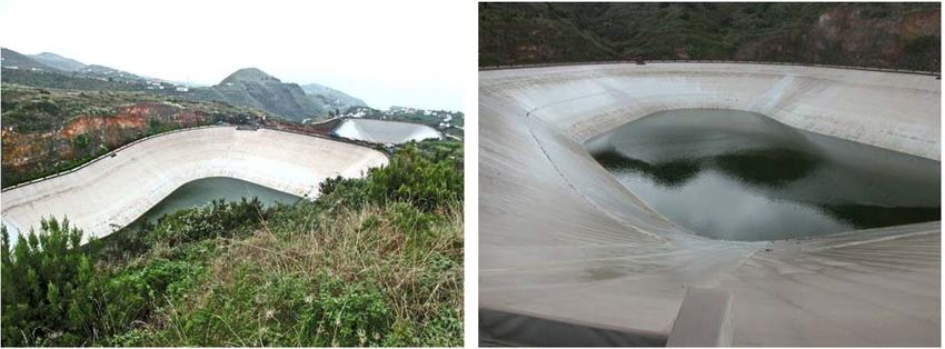
Figure 3: Barlovento reservoir in 2004, 13 years old Diameter 600m, 250.000 m2, PVC-P exposed geomembrane.
The geomembrane is anchored on the top, the toe, and in 3 anchoring trenches on the slopes. The
distances between anchoring trenches increase from top to toe and are respectively: 14.1O m, 15.20 m,
and 18.80 m. A band of geomembrane is put inside the trench, which is then filled with porous concrete.
The geomembrane on slope is cut at the level of each anchoring trench and welded to the band buried
into the trench. Each anchoring trench includes a draining pipe and has a longitudinal slope to evacuate
drained water. Storms with wind speed of about 160 km/h, on the mostly empty reservoir, have had no
effect on horizontal welding of anchoring, on anchoring itself or on the geomembrane.
3.3.2. Adeyahamen and Bedestia reservoirs
Those reservoirs are built to keep and store for irrigation purpose, the water coming from a hydroelectric
plant. the altitude The location of reservoirs must be between altitude of the plant and the level of the
agricultura! area. The local topographic conditions are absolutely unfavourable to such work: slopes very
steep, and gullies very narrow. To store 500,000 m3, it was necessary to built 2 ponds, each closed by a
dam about 40 m high, with an important draining system in the dam between the two ponds. Each pond is
buried in the rack. The upper reservoir, Adeyahamen (fig. 4), was built in 1994. lt is 26 m deep and its
RENOLIT Ibérica S.A.
Ctra. Del Montnegre, s/n
E- 08470 Sant Celoni (Barcelona)
Tel.: +34.93.8484000
Fax+3493.867.5517
www.alkorgeo.com
* *RENOLIT ALKORGEO
RENO LIT
lopes are 1.5 h 1 1v. The length of slopes is 47 m. The geomembrane is a 1.5 mm thick PVC-P,
homogeneous on the bottom and reinforced by polyester grid on slopes. The geomembrane is laid on a
geotextile and a porous concrete 1O cm thick, reinforced by a welded mesh. They are 2 horizontal anchor
lines on the slopes. They are made of reinforced concrete beams buried and anchored in the rock. The
geomembrane is mechanically secured by a steel bar bolted on the beam; the anchoring area is
waterproofed by a cover strip welded on the geomembrane. In 2005, the geomembrane has been
completely replaced by new 1.5 mm thick reinforced PVC-P, identical to that installed on
Barlovento reservoir.
Fig 4: View of Adeyahamen and Bedestia reservoirs, Fig 5: Adeyahamen reservoir, partially empty. One notices
buried in the rack. the first anchoring on slope
RENOLIT Ibérica S.A.
Ctra. Del Montnegre, s/n
E- 08470 Sant Celoni (Barcelona)
Tel.: +34.93.8484000
Fax+3493.867.5517
www.alkorgeo.com
* *RENOLIT ALKORGEO
RENO LIT
The lower reservoir, Bedestia (fig. 4, 5), was built in 2004. lt is 21m deep and its slopes are 1.5 h 1 1v. The
length of the slopes is 38 m. The geomembrane is a 1.5 mm thick PVC-P, reinforced by polyester grid
on slopes, and it is the same than the one used for Barlovento. The structure is similar to Adeyahamen,
but with only one anchoring line on slopes.
Fig. 6: Bedestia reservoir. View of the upstream side. The upper part of the dam between Adeyahamen and Bedestia
is at the far end of the picture.
Both ponds are localized just above the small city of San Andrés Y Sauces and it was necessary to avoid
any risk. Therefore, the downstream slope of the dam closing Adeyahamen, and closing the upstream
side of the Bedestia reservoir, has been reinforced with a complementary earth fill at the toe of the slope.
Although a general draining layer is installed below the geomembrane of the upper pond, a vertical
draining screen in the dam between both reservoirs has been installed and specific drainage was included
at the toe of the dam. (Soler Liceras 2004)
4. CONCLUSIONS
The Canary lslands have a very rich and long-term experience with all kind of geomembranes, exposed to
tropical climatic conditions. Their experience demonstrate that well formulated PVC-P geomembranes have
a long life time adapted to these needs and are very well adapted to hydraulic works, even with
complicated or very large geometry.
RENOLIT Ibérica S.A.
Ctra. Del Montnegre, s/n
E- 08470 Sant Celoni (Barcelona)
Tel.: +34.93.8484000
Fax+3493.867.5517
www.alkorgeo.com
* *RENOLIT ALKORGEO
RENO LIT
Figure 7: Bedestia reservoir. View from the crest of the Adeyahamen dam. The road is the top of reinforcement fill
enforcing the downstream slope of the dam. On the right side, the vertical surface is reinforced by a cyclopic wall. On
left side, the subvertical slope is directly buried in the rock.
RENOLIT Ibérica S.A.
Ctra. Del Montnegre, s/n
E- 08470 Sant Celoni (Barcelona)
Tel.: +34.93.8484000
Fax+3493.867.5517
www.alkorgeo.com
* *RENOLIT ALKORGEO
RENO LIT
REFERENCES
• Blanco, Manuel; Aguiar, Escolástico. "Aspectos más relevantes del comportamiento en obra de
los materiales sintéticos utilizados como geomembranas impermeabilizantes en embalses
ubicados en la Comunidad Autónoma de Canarias". Ingeniería Civil, 117/2000, pp. 25-35.
• Fayoux, D. and Van der Sype, D. "Durability of PVC-P-P geomembranes. Assessment after very
long UV exposure". Proceedings of 2nd European Geosynthetics Conference, Vol. 2, pp. 651 -
656.
• Fayoux, D. "La impermeabilización del embalse de la laguna de Barlovento" Jornadas sobre
impermeabilización con materiales sintéticos" Isla de la Palma, 2004 CEDEX 1 Consejo Insular
de Aguas de La Palma
• Soler Liceras, C. "Los embalses de Adeyahamen y Bedestia" Jornadas sobre impermeabilización
con materiales sintéticos" Isla de la Palma, 2004 CEDEXYou can also read