Flood Risk Information - Croydon Council
←
→
Page content transcription
If your browser does not render page correctly, please read the page content below
Flood Risk Information
V1.0 October 2020

This document provides supporting information to the CRF Multi-Agency
Flood Response Guidance.

Authored by:
Croydon Resilience Team
Place Department
Bernard Weatherill House, 8 Mint Walk
Croydon, CR0 1EA
emergencyplanning@croydon.gov.uk
NOT PROTECTIVELY MARKED

Contents
1     Topography Map of Croydon (2011) ...................................................................................................... 3
2     Key Infrastructure Map (with surface water flood risk) ........................................................................... 4
3     Fluvial Flood Risk Map (2015) ............................................................................................................... 5
4     Fluvial Flood Risk Zone Assessments ................................................................................................... 6
    4.1     River Wandle Flood Warning Zone ................................................................................................. 7
    4.2     Norbury Brook Flood Warning Zone ............................................................................................... 9
    4.3     Chaffinch Brook and St James Stream at Elmers End Flood Warning Zone ................................. 11
5     Surface Water Flood Risk Summary .................................................................................................... 13
    5.1     CDA Flood Risk Summary – CDA_040 Purley Cross ................................................................... 18
    5.2     CDA Flood Risk Summary – CDA_041 Brighton Road ................................................................. 19
    5.3     CDA Flood Risk Summary – CDA_043 South and Central Croydon ............................................. 20
6     Groundwater Flood Risk Summary ...................................................................................................... 21
    6.1     Caterham Bourne Catchment ....................................................................................................... 21
    6.2     Groundwater Alert for South East London .................................................................................... 21

               Croydon Flood Risk Information v1.0                                                                   Page 2 of 21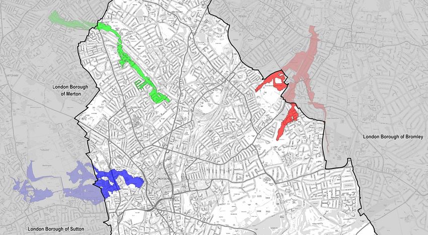
NOT PROTECTIVELY MARKED
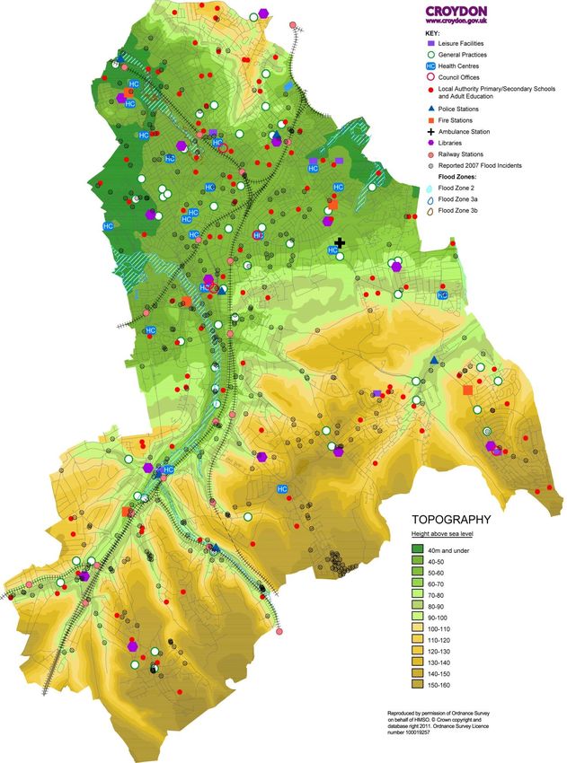
1 Topography Map of Croydon (2011)
Croydon Flood Risk Information v1.0 Page 3 of 21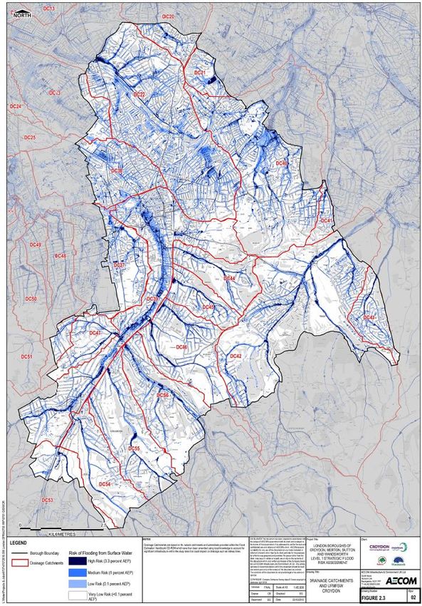
NOT PROTECTIVELY MARKED
2 Key Infrastructure Map (with surface water flood risk)

        Croydon Flood Risk Information v1.0                  Page 4 of 21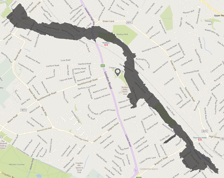
NOT PROTECTIVELY MARKED
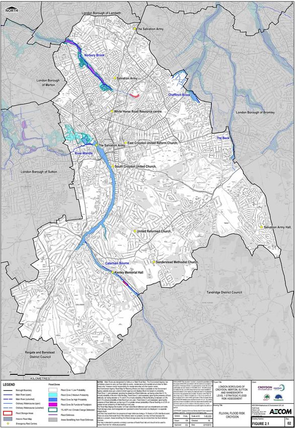
3 Fluvial Flood Risk Map (2015)
Croydon Flood Risk Information v1.0 Page 5 of 21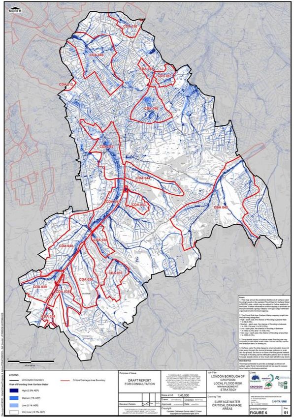
NOT PROTECTIVELY MARKED
4 Fluvial Flood Risk Zone Assessments
There are 3 flood zones as defined by the EA; Flood Zone 1, 2 and 3. The flood zones are based on the
likelihood of an area flooding, with flood zone 1 areas least likely to flood and flood zone 3 areas more likely
to flood. Flood zone 3b’s are classified as functional floodplain, and are deemed to be the most at risk land
of flooding. In Croydon, as Table 1 demonstrates, there are 235 residential properties at the highest risk of
flooding.

                Table 1 - Properties at risk of fluvial flooding in London Borough of Croydon by Flood Zone (2015)

The Environment Agency acknowledges three fluvial Flood Warning Areas (FWA) in the London Borough of
Croydon. These are as follows:

 Flood Warning Area                                                                      FWA Code
 The River Wandle at Beddington Park                                                     064WF41BeddPark
 The Norbury Brook at Thornton Heath and Streatham Vale                                  064FWF41Norbury
 Chaffinch Brook and St James Stream at Elmers End                                       064FWF43UpprElm

                                      Figure 1 - Croydon Flood Warning Areas (2015, SFRA)

           Croydon Flood Risk Information v1.0                                                          Page 6 of 21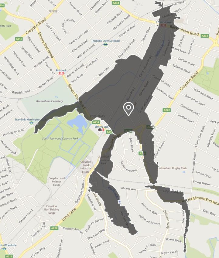
NOT PROTECTIVELY MARKED
4.1   River Wandle Flood Warning Zone

                                 Figure 2 – Flood map for Wandle flood warning zone

Please note: the FWA area information on the following page, sourced by the Environment Agency, may
have slight inaccuracies (e.g. property numbers) or omissions (e.g. new infrastructure) as the current
assessment is a now few years old and awaiting a revision as part of the Agency review cycle.

          Croydon Flood Risk Information v1.0                                         Page 7 of 21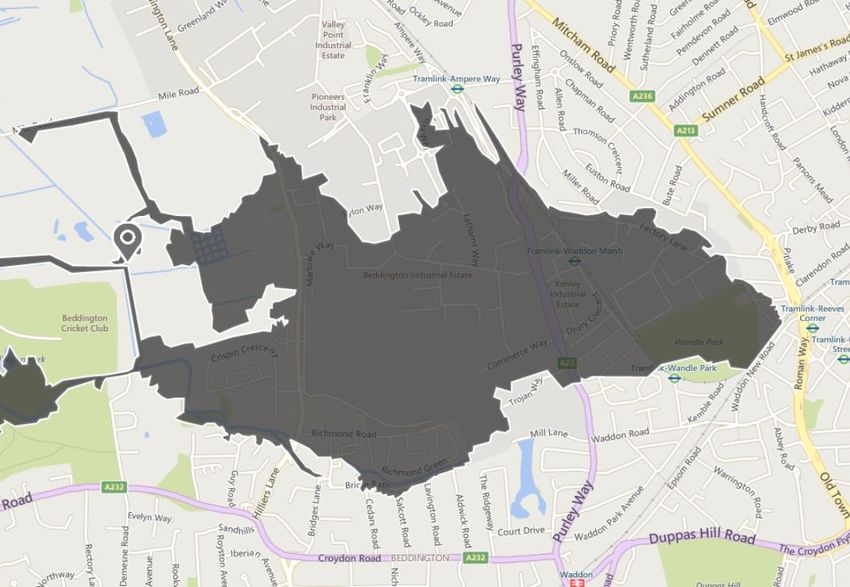
NOT PROTECTIVELY MARKED
Flood Warning Area Flood Warning Area Reference Code
The River Wandle at Beddington Park 064FWF41BeddPark
Locations Affected Messages Issued (EA)
Flood Warning
The area within the Borough contained in this flood
Flood Warning Update
warning area is bounded by Roman Way spreading
Severe Flood Warning
west across Wandle Park across the Purley Way to
Floodline Quickdial Code
the boundary with the London Borough of Sutton. The
north boundary is Factory Lane and Beddington Farm 173802
Road. The south boundary is the edge of Wandle Lead Time
Park through to Mill Lane.
2 hours
Frequency of Probability of Properties at Properties registered on Floodline Warnings
Flooding Flooding Risk Direct
1:1000 0.1% (low) 1450 Extended Direct
Fully
1:100 1% (medium) 257 Warnings*
1:20 5% (high) 18
182 942
1:5 20% (very high) 6
Key Infrastructure
Southern Network Gas Holder site, Factory
A23
Lane
A236
Tram line
Kingsley Primary School, Thomson Crescent
History of Flooding
Month / Year Number of Properties / areas affected
6 properties flooded (2 properties flooded, Wood Street and New Road in
July 2007
Mitcham. 4 properties flooded Richmond Green and Beddington)
1991 41 properties flooded
August 1981 89 properties flooded
1979 3 properties flooded
1978 21 properties flooded
1977 59 properties flooded
1975 20 properties flooded, including 15 in Beddington
1970 59 properties flooded
September 1968 54 properties flooded
1966 10 properties flooded
Flood Defences / Alleviation Measures
As the result of frequent flooding, the River Wandle has had major flood alleviation works carried out along its
length from the River Thames to Richmond Green. Wandle Park and Beddington Park act as flood plains to
take additional river flows.
Other Information
On receipt of a flood warning, Wandle Park and Beddington Park are expected to flood. It is
anticipated that water may accumulate on roads, it is not expected that properties will flood to any
great depth. It is possible that the car parks on the retail parks of Purley Way will flood.
*Properties can benefit from full registration or Extended Direct Warnings (EDW) - a limited opt-out service
to homes and businesses at ‘high-risk’ from flooding, who are currently not registered to receive warnings.
Croydon Flood Risk Information v1.0 Page 8 of 21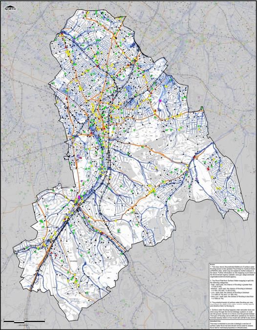
NOT PROTECTIVELY MARKED
4.2   Norbury Brook Flood Warning Zone

                             Figure 3 – Flood map for Norbury Brook Flood Warning Zone

Please note: the FWA area information on the following page, sourced by the Environment Agency, may
have slight inaccuracies (e.g. property numbers) or omissions (e.g. new infrastructure) as the current
assessment is a now few years old and awaiting a revision as part of the Agency review cycle.

          Croydon Flood Risk Information v1.0                                            Page 9 of 21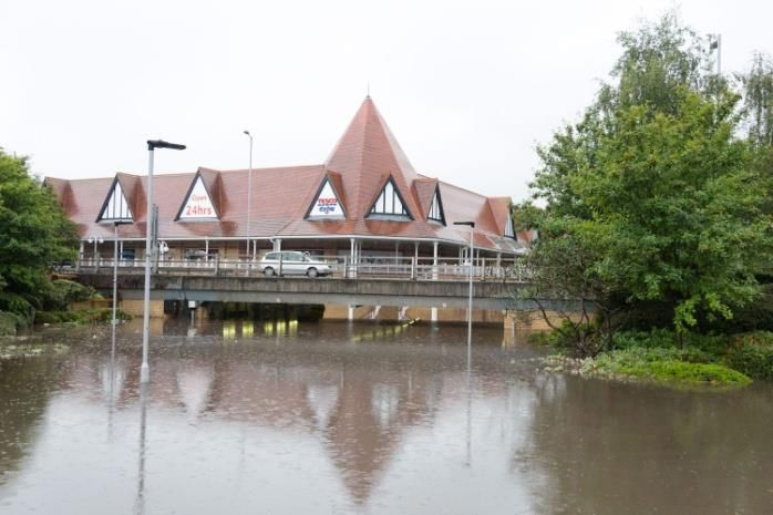
NOT PROTECTIVELY MARKED
Flood Warning Area Flood Warning Area Reference Code
The Norbury Brook at Thornton Heath and
064FWF41Norbury
Streatham Vale
Locations Affected Messages Issued (EA)
The Norbury Brook (River Graveney) is the main Flood Warning
tributary of the River Wandle. It flows through Flood Warning Update
industrial and residential areas. Areas at risk include: Severe Flood Warning
Thornton Heath – Boswell Road, Zermatt Road,
Floodline Quickdial Code
Geneva Road, Lucern Road, Brook Road, Elliott
Road, Bremar Avenue, Strathyre Avenue, Kilmartin
Avenue, Dunbar Avenue, Melrose Avenue, Ederline 173801
Avenue, Dalmeny Avenue, Craignish Avenue,
Norbury Crescent and Norbury Avenue.
Lead Time
Norbury – Kuala Gardens and Granville Gardens.
2 hours
Frequency of Probability of Properties at Properties registered on Floodline Warnings
Flooding Flooding Risk Direct
1:1000 0.1% (low) 1971 Extended Direct
Fully
1:100 1% (medium) 1130 Warnings*
1:20 5% (high) 259
169 1581
1:5 20% (very high) 4
Key Infrastructure
Kensington Avenue Infant School, Kensington Avenue
Kensington Avenue Junior School, Kensington Avenue
History of Flooding
Month / Year Number of Properties / areas affected
July 2007 1 property flooded, Dalmeny Avenue
July 1997 9 properties flooded
1983 39 properties flooded
September 1973 175 properties flooded
September 1968 14 properties flooded
Flood Defences / Alleviation Measures
Due to the increased need for housing in South London, various improvement schemes were put in place by
Surrey County Council to reduce risk from the 1920s onwards. This involved construction of concrete walls,
flood defences and culverts. The scheme was designed to provide a level of protection to approximately a 1
in 50 year flood event (2% probability in any given year). This scheme is currently being reviewed as part of
the Wandle and Graveney Strategy.
Other Information
On receipt of a flood warning, it is expected that Norbury Park will flood and take most of the excess
water, properties adjoining the park may flood but it is not anticipated to any great depth.
A key issue in this catchment is the ongoing problem of fly-tipping and high levels of rubbish in the
Norbury Brook. This causes an increased risk of blockages, particularly at trash screens.
*Properties can benefit from full registration or Extended Direct Warnings (EDW) - a limited opt-out service
to homes and businesses at ‘high-risk’ from flooding, who are currently not registered to receive warnings.
Croydon Flood Risk Information v1.0 Page 10 of 21NOT PROTECTIVELY MARKED
4.3 Chaffinch Brook and St James Stream at Elmers End Flood Warning Zone
Figure 4 – flood map of Chaffinch Brook Flood Warning Zone
Please note: the FWA area information on the following page, sourced by the Environment Agency, may
have slight inaccuracies (e.g. property numbers) or omissions (e.g. new infrastructure) as the current
assessment is a now few years old and awaiting a revision as part of the Agency review cycle.
Croydon Flood Risk Information v1.0 Page 11 of 21NOT PROTECTIVELY MARKED
Flood Warning Area Reference
Flood Warning Area
Code
The Chaffinch Brook and St James Stream at Elmers End and Upper
064FWF43UpprElm
Elmers End
Locations Affected Messages Issued (EA)
The Chaffinch Brook flows from Croydon through Beckenham to the Flood Warning
River Ravensbourne confluence and is joined by St. James Stream. Flood Warning Update
In the lower reaches, the Chaffinch Brook is known as the Pool River. Severe Flood Warning
Areas at risk include: Floodline Quickdial Code
Chaffinch Brook (Upper Elmers End to Elmers End) - Horton Way, 173911
Mallard Way, Puffin Close, Croydon Road, Elmers End Road, Lead Time
Wimbourne Way, Clock House Road and Forster Road. St James’
Stream - Altyre Way, Upper Elmers End Road, Holly Close, Priory Close 2 hours
and St. James’ Avenue.
Frequency of Probability of Properties at Properties registered on Floodline Warnings
Flooding Flooding Risk Direct
1:1000 0.1% (low) 1516 Extended Direct
Fully
1:100 1% (medium) 429 Warnings*
1:20 5% (high) 158
132 1451
1:5 20% (very high) 42
Key Infrastructure
Monks Orchard Primary School
History of Flooding
Month / Year Number of Properties / areas affected
Around 40mm of rain fell on 20 July, causing the Spring Brook to come out of
banks. There was also a blockage on a trash screen. 3 business flooded on
July 2007
Bromley Road (junction with Downham Lane) and 9 houses flooded on
Downham.
1997 3 properties flooded and 1 road flooded
August 1981 47 properties flooded
1974 41 properties flooded
1973 47 properties flooded
1969 6 properties flooded
Extensive flooding was experienced; numerous properties and roads were
1968 September
affected in the Orpington, Bromley and Chislehurst areas.
Flood Defences / Alleviation Measures
Croydon secured Government funding in 2018 and is working jointly with Bromley Council and the EA to
undertake a feasibility flood alleviation study which will look into the flooding mechanism within the Chaffinch
Brook catchment, and identify viable/affordable long term measures that could be implemented to better
manage the flood risks. The study in currently in the Optioneering Stage and is anticipated to be completed
by December 2020. Although this date may now change due to the impact of the COVID-19
Other Information
On receipt of a flood warning, it is expected that some flooding of roads and a little in property will
occur.
The Ravensbourne Catchment is highly urbanised, and has many debris screens throughout the
catchment. These screens are very susceptible to blockages and can cause flooding at many
locations. Proactive action is taken to try to ensure that screens are kept clear, especially when the
weather forecast is poor.
*Properties can benefit from full registration or Extended Direct Warnings (EDW) - a limited opt-out service
to homes and businesses at ‘high-risk’ from flooding, who are currently not registered to receive warnings.
Croydon Flood Risk Information v1.0 Page 12 of 21NOT PROTECTIVELY MARKED
5 Surface Water Flood Risk Summary
According to national research undertaken by Defra1, Croydon is ranked the 4th settlement in England most
susceptible to surface water (pluvial) flooding, with as many as 21,100 properties estimated to be at risk.
London Borough of Croydon’s growth strategy provides an increase of approximately 21,510 new homes and
many new jobs; these plans for urbanisation and redevelopment within London Borough of Croydon present
a significant challenge to the existing drainage systems. Table 4 dissects the number of residential and non-
residential properties at a low, medium and high risk of surface water flooding in Croydon, based on the
Environment Agency’s ‘Flood Risk for Surface Water’ mapping.
Direct rainfall modelling has been undertaken across the entire Borough for five specified return periods. The
results of this modelling have been used to identify Local Flood Risk Zones (LFRZs) where flooding affects
houses, businesses or infrastructure. Those areas identified to be at more significant risk have been
delineated into Critical Drainage Areas (CDAs) representing one or several LFRZs as well as the contributing
catchment area and features that influence the predicted flood extent.
Within the London Borough of Croydon, sixteen CDAs have been identified and can be seen in Figure 6.
The chief mechanisms for flooding can be broadly divided into two categories;
Scattered Flooding Incidents - geographically dispersed and relatively isolated flooding of individual
properties or small groups of properties (e.g. Chipstead Valley Road, Woodside, South Norwood);
More Severe Pluvial Flooding – more significant pluvial flooding with interlinked sources of flooding,
multiple asset owners and typically affecting a significantly greater number of properties (e.g.,
Brighton Road, Purley Cross and South and Central Croydon).
CDA_043 South and Central Croydon, CDA_041 Brighton Road and CDA_040 Purley Cross have the
greatest number of receptors at risk of flooding, in proportion to the size of the CDA. The CDA for South and
Central Croydon is also identified to have the greatest amount of critical infrastructure at risk and the highest
number of commercial properties.
No single organisation has overall responsibility for surface water flooding with different aspects of the
drainage system falling to either The Highway Authority (in this case London Borough of Croydon Council),
Thames Water, riparian owners and Transport for London (red routes including the A23, A24 and A232).
July 2020 update: the SWMP and the CDAs are currently being reviewed by the council’s Professional
Services Provider, Arcadis. Additional hydraulic modelling works are being undertaken which may see
existing CDAs extended or new ones created.
1 National Rank Order of Settlements Susceptible to Surface Water Flooding, Defra 2009
Croydon Flood Risk Information v1.0 Page 13 of 21NOT PROTECTIVELY MARKED Table 2 - Properties at risk of surface water flooding in London Borough of Croydon by Drainage Catchment (2015) Croydon Flood Risk Information v1.0 Page 14 of 21
NOT PROTECTIVELY MARKED
                                Table 3 - Properties at risk of surface water flooding

No. Properties at Risk of Surface Water Flooding in Croydon                                         At Risk
(based on Environment Agency ‘Flood Risk for Surface Water’
                                                                                          Low      Medium         High
mapping)
Residential Total                                                                        33,614     10,440        3,714
                      Commercial & Industrial                                            2,455      1,272         578
                                                    Emergency Services
                                                    (Fire, Police &                       11          6            3
                                                    Ambulance Station)
                                                    Hospitals                              3          3            2
                                                    Schools and Education
                                                                                          134         72           35
                      Critical Infrastructure       Facilities
Non Residential                                     Surgery or Health Care                67          32           12
                                                    Residential Home                       5          1            1
                                                    Sewage Treatment                       3          2            1
                                                    Electricity Sub Station or
                                                                                          68          27           14
                                                    Building
                      Other                                                               147         63           34
                                                       Non Residential Total             2,893      1,478         680
                                                                              Total      36,507     11,918        4,394

         Croydon Flood Risk Information v1.0                                                      Page 15 of 21
NOT PROTECTIVELY MARKED
Figure 5 - Map of Surface Water Flooding with drainage catchments (2015)
Croydon Flood Risk Information v1.0 Page 16 of 21NOT PROTECTIVELY MARKED
Figure 6 - Surface Water Critical Drainage Areas (2014)
Croydon Flood Risk Information v1.0 Page 17 of 21NOT PROTECTIVELY MARKED
5.1 CDA Flood Risk Summary – CDA_040 Purley Cross
CDA_040 Purley Cross
Flood Risk Categorisation Surface water and ordinary watercourse
This CDA covers the section of Brighton Road from Coulsdon Town Rail
Station northwards to the Purley Cross junction.
Brighton Road is located in a natural depression along the former
pathway of the River Wandle.
During periods of heavy rainfall, surface water flows down the side roads
Description and ponds along Brighton Road resulting in highway flooding and
flooding of properties on either side of the highway.
Accordingly, reported incidents of flooding are concentrated along
Brighton Road.
Due to its location in a topographic depression, the pluvial modelling
identifies this area to be susceptible to significant depths of flooding.
Approximately 2316 Non-deprived2 Approximately 101 Non-deprived
households and 83 commercial households and 20 commercial
Property Count
properties flood to a depth of greater properties flood to a depth of greater
than 0.03m. than 0.5m.
A23 TfL red route from London to Brighton
2 Fire Stations
Critical Infrastructure Electrical substation
Schools
Community Centres
Residential Homes
This area floods almost every year.
The Purley Cross junction has historically experienced severe flooding,
most notably in July 2007 when approx. 320 properties and 26 schools
reported surface water flooding, and the gyratory system including the
surface water pumping system was completely submerged beneath 2 to
Validation / History of 3 metres of floodwater.
Flooding There are 16 records of flooding within this CDA since 1961.
There are 12 records of pluvial flooding at Purley Cross, Brighton Road,
Woodcote High School, Russell Hill Road, Smitham Bottom Lane, The
Chase, The Horseshoe and Old Lodge Lane.
In addition there are records of sewer flooding at Brighton Road, Old
Lodge Lane, Reedham Drive, Foxley Lane and Purley Cross
Figure 7 - 2007 Flooding at Purley Cross Figure 8 - 2015 Flooding at Purley Cross
2(Non-) Deprived Households: Those households (not) falling into the lowest 20% of ranks by the Office of National
Statistics’ Indices of Multiple Deprivation.
Croydon Flood Risk Information v1.0 Page 18 of 21NOT PROTECTIVELY MARKED
5.2 CDA Flood Risk Summary – CDA_041 Brighton Road
CDA 041 Brighton Road
Flood Risk Categorisation Surface Water, Culverted Ordinary Watercourse
Brighton Road is located along the former pathway of the River Wandle.
During periods of heavy rainfall, surface water is channelled from higher
land in Kenley and Sanderstead towards Purley and ponds along the
length of Brighton Road.
The Brighton Road is defined as Environment Agency Flood Zone 3a
Description however the watercourse is entirely culverted along this section and
joins the River Wandle in neighbouring London Borough of Sutton.
Croydon secured Government funding in 2019, to undertake hydraulic
modelling of Brighton Road between Purley Cross and the River
Wandle, which hope to improve our understanding of the flood risks in
this area.
Approximately 2357 Non-deprived Approximately 163 Non-deprived
households and 373 commercial households and 26 commercial
Property Count
properties flood to a depth of greater properties flood to a depth of greater
than 0.03m. than 0.5m.
TfL Red Route (A23)
Hospital
Critical Infrastructure Fire Station
Brighton Road Bus Depot
Electrical substation
There are records of flooding at more than 8 locations along this section
of Brighton Road.
During the 20th of July 2007 flood event, reportedly more than 50
Validation / History of properties reported to be affected by surface water flooding along the
Flooding Brighton Road corridor. The capacity of the surface water drainage
system was overwhelmed and the residual surface water resulted in
roadway and property flooding. Flooding extended beyond the Brighton
Road frontage to adjacent roads and properties.
Croydon Flood Risk Information v1.0 Page 19 of 21NOT PROTECTIVELY MARKED
5.3 CDA Flood Risk Summary – CDA_043 South and Central Croydon
CDA 042 South & Central Croydon
Flood Risk Categorisation Surface Water, Culverted Ordinary Watercourse
This CDA covers the upper extent of Brighton Road extending from
Haling Park to Wandle Park.
Surface water flows into the channel of the former River Wandle in the
Description area designated as Environment Agency Flood Zone 3a and ponds to
significant depths.
Surface water is shown to pond beneath the Croydon flyover and the
subways beneath Mitcham Road including Booth Road and Bourne
Street.
Approximately 3450 Non-deprived
Approximately 349 Non-deprived
households of which 431 are
households of which 25 are
basements; 327 Deprived
basements; 5 Deprived households,
households, of which 17 are
Property Count or which 3 are basements; and 49
basements; and 830 commercial
commercial properties, of which 11
properties, of which 464 are
are basements, flood to a depth of
basements, flood to a depth of
greater than 0.5m.
greater than 0.03m.
A23 TfL Red Route
Fire Station, Duppas Hill Terrace
Sewage Treatment Works
Critical Infrastructure 14 Electrical substations
Police Station, Wellesley Road
Croydon Hospital
Tram network (Reeves Corner and Central stations)
London Borough of Croydon has records of pluvial flooding at 33
locations within this CDA including Wellesley Road (Croydon
underpass), Brighton Road, Haling Park Road, Church Street, Cliffe
Road, Howard Primary School, Duppas Hill Terrace, North End, Park
Validation / History of Lane, Parker Road, Queen Street, Southbridge Place, Waddon Road,
Flooding Warham Road, Warrington Road, Barlett Street, Selsdon Road,
Incidents of sewer flooding have been recorded at Purley Road, Miller
Road and North End.
Incidents of groundwater flooding have been recorded at Barham Road,
Brighton Road and Church Road.
Croydon Flood Risk Information v1.0 Page 20 of 21NOT PROTECTIVELY MARKED
6 Groundwater Flood Risk Summary
The borough of Croydon is divided into two distinct areas with respect to bedrock geology. The north of the
borough is underlain by impermeable London Clay, whereas the south is underlain by permeable chalk. The
Council have 37 records of groundwater flooding in the borough. Instances of groundwater flooding have
been reported in a number of areas in Croydon with some regular hotspots in the north of the borough. The
most high profile and widespread floods influenced by high groundwater have been associated with the
Caterham Bourne in the south of the borough, which caused significant disruption in the winter of 2000-2001
and more recently in early 2014, threatening significant numbers of homes, essential infrastructure and
transport networks. Appendix L displays the flood risk posed in Croydon from groundwater.
6.1 Caterham Bourne Catchment
The Caterham Bourne is an ephemeral watercourse, meaning it flows intermittently usually after periods of
heavy or prolonged rainfall, and is predominantly dry at other times. Historically, it is recorded to flow heavily
approximately every 7 years, although smaller flows can be observed more frequently. The bourne rises in
Surrey within the district of Tandridge. The source location is reported to vary with three valley flow paths
leading towards the Wapses Lodge roundabout on the A22 in Surrey. The EA map the start of the designated
main river at Wapses lodge, where the three flow paths combine.
The route of the bourne flows in a North West direction through Whyteleafe and into Croydon, roughly
following the course of the A22, through Kenley to Purley Cross in Croydon. The bourne then flows within a
culvert, flowing north east under Brighton Road to the balancing pond at the Purley Oaks depot. The bourne
continues to flow in a northerly direction, mostly within culverts, eventually joining the River Wandle at
Waddon. More information on the catchment can be found in the Caterham Bourne Flood Investigation
Report3.
Areas at risk of Groundwater Flooding in the Caterham Bourne Catchment including Caterham, Whyteleafe,
Kenley, Purley, South Croydon, Beddington and Carshalton
The Environment Agency provides a Flood Alert service to the groundwater flooding in the Caterham Bourne
catchment – the only groundwater flood alert area in London. Appendix K displays the catchment area; the
Flood Alert Reference Code is 064FAG41Caterham.
6.2 Groundwater Alert for South East London
The Groundwater Flood Alert area has recently been expanded to include areas that have been previously
affected or could be affected by groundwater flooding. This new service will mean members of the public
living within areas that could be affected by groundwater flooding can register to receive Groundwater Flood
Alerts.
3
https://www.croydon.gov.uk/sites/default/files/articles/downloads/Caterham%20Bourne%20S19%20Flood%20Investig
ation%20Report%20%E2%80%93%20October%202014%202.pdf
Croydon Flood Risk Information v1.0 Page 21 of 21You can also read