FLOOD RISK ASSESSMENT - Asda Gloucester - rpsgroup.com - Gloucester City Council
←
→
Page content transcription
If your browser does not render page correctly, please read the page content below
FLOOD RISK ASSESSMENT
Asda Gloucester

                              HLEF81441
                        Asda Gloucester
                                       3
                          3rd March 2022

                        rpsgroup.com
REPORT

Quality Management

Version      Status                   Authored by            Reviewed by        Approved by        Review date

1            Draft                                                                                 30/11/2021

2            Final                                                                                 20/12/2021

             Comments from
3            Gloucester City                                                                       03/03/2022
             Council addressed

Approval for issue

                                                                                 3 March 2022

© Copyright RPS Group Plc. All rights reserved.
The report has been prepared for the exclusive use of our client and unless otherwise agreed in writing by
RPS Group Plc, any of its subsidiaries, or a related entity (collectively 'RPS'), no other party may use, make
use of, or rely on the contents of this report. The report has been compiled using the resources agreed with
the client and in accordance with the scope of work agreed with the client. No liability is accepted by RPS for
any use of this report, other than the purpose for which it was prepared. The report does not account for any
changes relating to the subject matter of the report, or any legislative or regulatory changes that have occurred
since the report was produced and that may affect the report. RPS does not accept any responsibility or liability
for loss whatsoever to any third party caused by, related to or arising out of any use or reliance on the report.
RPS accepts no responsibility for any documents or information supplied to RPS by others and no legal liability
arising from the use by others of opinions or data contained in this report. It is expressly stated that no
independent verification of any documents or information supplied by others has been made. RPS has used
reasonable skill, care and diligence in compiling this report and no warranty is provided as to the report’s
accuracy. No part of this report may be copied or reproduced, by any means, without the prior written consent
of RPS.

 Prepared by:                                            Prepared for:

 RPS                                                     Euro Garages

HLEF81441 | Asda Gloucester | 3 | 3rd March 2022
rpsgroup.com
REPORT

Contents
1        INTRODUCTION ................................................................................................................................ 1
2        PLANNING POLICY CONTEXT ........................................................................................................ 2
3        CONSULTATION ............................................................................................................................... 4
4        SITE DESCRIPTION .......................................................................................................................... 5
5        PROPOSED DEVELOPMENT........................................................................................................... 7
6        HYDROLOGICAL SETTING.............................................................................................................. 8
7        HYDROGEOLOGICAL SETTING.................................................................................................... 13
8        FLOOD RISK AND MITIGATION .................................................................................................... 14
9        SEQUENTIAL TEST AND EXCEPTION TEST ............................................................................... 18
10       SUMMARY AND CONCLUSIONS .................................................................................................. 19

Tables
Table 1. Proposed mitigation ...................................................................................................................... 19

Figures
Figure 4-1. Site Location............................................................................................................................... 5
Figure 6-1. EA Flood Map for Planning ........................................................................................................ 9
Figure 6-2 - Flood extent and levels during the 1 in 100-year plus 20% climate change event................. 10
Figure 6-3. Updated Flood Map for Surface Water .................................................................................... 11
Figure 8-1 - Proposed Flood Compensatory Storage ................................................................................ 15

Appendices
Appendix A EA Detailed Flood Data
Appendix B Topographic Survey
Appendix C Development Plans

HLEF81441 | Asda Gloucester | 3 | 3rd March 2022
rpsgroup.com                                                                                                                                          Page iii

REPORT

1           INTRODUCTION
1.1         RPS was commissioned to prepare a Flood Risk Assessment (FRA) for a site located within the car
            park of Asda Gloucester, Bruton Way, Gloucester, GL1 1DS in relation to a proposed development
            of a restaurant with a drive thru.
1.2         The aim of the FRA is to outline the potential for the site to be impacted by flooding, the impacts of
            the proposed development on flooding in the vicinity of the site, and the proposed measures which
            could be incorporated into the development to mitigate the identified risk. The report has been
            produced in accordance with the guidance detailed in the National Planning Policy Framework
            (NPPF) and the associated Planning Practice Guidance (PPG). Reference has also been made to
            the Gloucestershire County Council Level 1 and Gloucester City Council Level 1 & 2 Strategic Flood
            Risk Assessment (SFRA).
1.3         This report has been produced in consultation with the Environment Agency (EA) and the Lead Local
            Flood Authority (LLFA). The site is not located within an Internal Drainage Board (IDB) District.
1.4         The desk study was undertaken by reference to information provided / published by the following
            bodies:
            •     Environment Agency (EA);
            •     Gloucester City Council (GC);
            •     Gloucestershire County Council (GCC);
            •     Centre for Ecology and Hydrology;
            •     British Geological Survey (BGS);
            •     Ordnance Survey (OS); and
            •     Severn Trent Water (STW).

HLEF81441 | Asda Gloucester | 3 | 3rd March 2022
rpsgroup.com                                                                                               Page 1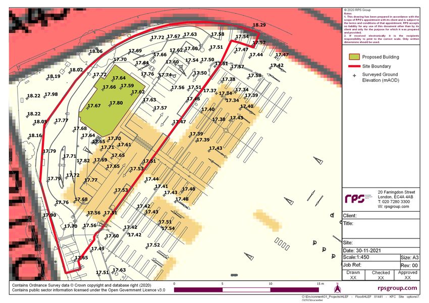
REPORT

2           PLANNING POLICY CONTEXT
            National Planning Policy
2.1         The National Planning Policy Framework (NPPF) was released in March 2012 and was updated in
            July 2021. The document advises of the requirements for a site-specific Flood Risk Assessment
            (FRA) for any of the following cases (Planning and Flood Risk paragraph 167 (footnote 55)):
            •     All proposals (including minor development and change of use) located within the EA
                  designated floodplain, recognised as either Flood Zone 2 (medium probability) or Flood Zone
                  3 (high probability);
            •     All proposals of 1 hectare (ha) or greater in an area located in Flood Zone 1 (low probability);
            •     All proposals within an area which has critical drainage problems (as notified to the Local
                  Planning Authority by the EA);
            •     Land identified in a strategic flood risk assessment as being at increased flood risk in future;
                  and
            •     Where proposed development may be subject to other sources of flooding, where its
                  development would introduce a more vulnerable use.
2.2         Paragraph 169 of the updated NPPF identifies that major developments (developments of 10 homes
            or more and to major commercial development) should incorporate Sustainable Drainage Systems
            unless there is clear evidence that this would be inappropriate. The systems used should:
           a.    Take account of advice from the Lead Local Flood Authority;
           b.    Have appropriate proposed minimum operational standards;
           c.    Have maintenance arrangements in place to ensure an acceptable standard of operation for the
                 lifetime of the development; and
           d.    Where possible, provide multifunctional benefits.
2.3         Defra published their ‘Non-statutory technical standards for sustainable drainage systems’ in March
            2015. These are supported by the revised NPPF.

            Local Planning Policy
2.4         The Gloucester City Council Core Strategy contains Policy INF2 relating to Flood Risk Management:
           a.    Development proposal must avoid areas at risk of flooding, in accordance with a risk- based
                 sequential approach. Proposals must not increase the level of risk to the safety of occupiers of
                 a site, the local community or the wider environment either on the site or elsewhere. For sites
                 of strategic scale, the cumulative impact of the proposed development on flood risk in relation
                 to existing settlements, communities or allocated sites must be assessed and effectively
                 mitigated.
            b.    Minimising the risk of flooding and providing resilience to flooding, taking into account climate
                  change, will be achieved by:
            •     Requiring new development to, where possible, contribute to a reduction in existing flood risk;
            •     Applying a sequential test for assessment of applications for development giving priority to land
                  in Flood Zone 1, and, if no suitable land can be found in Flood Zone 1, applying the exception
                  test;
            •     Requiring new development that could cause or exacerbate flooding to be subject to a flood
                  risk assessment which conforms to national policy and incorporates the latest available updates

HLEF81441 | Asda Gloucester | 3 | 3rd March 2022
rpsgroup.com                                                                                                 Page 2
REPORT

                  to modelling and climate change data and historic data and information and guidance contained
                  in the authorities’ Strategic Flood Risk Assessments and Supplementary Planning Documents,
                  in order to demonstrate it will be safe, without increasing flood risk elsewhere;
            •     Requiring new development to incorporate suitable Sustainable Drainage Systems (SuDS)
                  where appropriate in the view of the local authority to manage surface water drainage: to avoid
                  any increase in discharge into the public sewer system; to ensure that flood risk is not increased
                  on-site or elsewhere; and to protect the quality of the receiving watercourse and groundwater.
                  Where possible, the authorities will promote the retrofitting of SuDS and encourage
                  development proposals to reduce the overall flood risk through the design and layout of
                  schemes which enhance natural forms of drainage. Developers will be required to fully fund
                  such mitigation measures for the expected lifetime of the development including adequate
                  provision for ongoing maintenance;
            •     Working with key partners, including the Environment Agency and Gloucestershire County
                  Council, to ensure that any risk of flooding from development proposals is appropriately
                  mitigated and the natural environment is protected in all new development.
2.5         The Gloucestershire County Council and the Gloucester City Council SFRAs identify and map flood
            risk from all sources at a borough-wide scale as well as providing guidance on producing site specific
            FRAs. Relevant information from the SFRA has been referenced throughout this FRA report.

HLEF81441 | Asda Gloucester | 3 | 3rd March 2022
rpsgroup.com                                                                                                 Page 3
REPORT

3           CONSULTATION
            Environment Agency
3.1         The FRA has been prepared in consultation with Diane Edwards, Customers and Engagement
            Officer – West Midlands Area at the EA. Modelled flood data has been requested at the site location,
            as well as details of historic flooding and flood defences within the vicinity of the site. The information
            provided by the EA is included as Appendix A and is summarised in Section 6.

            Lead Local Flood Authority and Local Planning Authority
3.2         The site is within the administrative boundary of Gloucester City Council. Consultation has been
            undertaken with the flood risk department. Data has been requested with regards to historic flooding,
            flood defences, modelled flood levels, hazard mapping and information on groundwater flooding
            issues in the area. At the time of writing, a response is pending.
3.3         The LLFA is Gloucestershire County Council.

            Internal Drainage Board
3.4         The site is not located within an IDB District.

HLEF81441 | Asda Gloucester | 3 | 3rd March 2022
rpsgroup.com                                                                                                    Page 4
REPORT

4            SITE DESCRIPTION
             Site Description
4.1          The site is located at National Grid Reference SO 83769 18402 and is irregular in shape and
             occupies an area of approximately 0.22 hectares (ha). The site location is presented in Figure 4-1.

                Subject Site

 © Crown copyright and database rights 2020 OS 100024198. Use of the address and mapping data is subject to the terms and conditions.

        Figure 4-1. Site Location

4.2          The site is currently part of the car park of Asda Gloucester.
4.3          Vehicular access is through the main access of the Asda carpark off Metz Way to the east of the
             site.
4.4          The entire site currently surfaced with low permeability hardstand.

HLEF81441 | Asda Gloucester | 3 | 3rd March 2022
rpsgroup.com                                                                                                                            Page 5
REPORT

            Surrounding Land Uses
4.5         The surrounding land uses are predominately commercial to the west and to the north of the site
            with some mixed-use buildings comprising of commercial ground floors and residential upper floors.
            Gloucester train station is located to the north-west of the site and the railway line runs from the
            north of the site to the east. Gloucester Royal Hospital is located to the north of the site just across
            the railway line.
4.6         There are no designated sensitive areas (e.g. Special Area of Conservation (SAC), Special
            Protection Area (SPA) or Site of Special Scientific Interest (SSSI)) within close proximity to the site.

            Topography
4.7         A topographic survey was completed by West Coast Geomatics in October 2021, reference WCG
            21 - 1669, and indicates that the site is predominately flat with levels ranging from 17.44m AOD in
            the south west to 17.87m AOD in the west. At the proposed location of the building, the ground level
            ranges between 17.58m AOD to 17.77m AOD. The topographic survey is located in Appendix B.

HLEF81441 | Asda Gloucester | 3 | 3rd March 2022
rpsgroup.com                                                                                                 Page 6
REPORT

5           PROPOSED DEVELOPMENT
5.1         The proposal is for a drive thru restaurant within the Asda car par in the north west. Development
            plans are shown in Appendix C.
5.2         Access to the site will be available from the main entrance of the car park off Metz Way.
5.3         The proposal will not impact the impermeable area at the site as the existing site comprises of 100%
            hardstanding cover; however, the development will increase the building footprint at the site as it
            proposes the erection of a commercial restaurant building. The proposed building footprint accounts
            for approximately 220m2.
5.4         The proposed use of the site is classified as ‘less vulnerable’ within the PPG.
5.5         The potential to provide surface water attenuation, including the use of Sustainable Drainage
            Systems (SuDS), has not been considered as part of this flood risk assessment as it was not in the
            scope of this report.

HLEF81441 | Asda Gloucester | 3 | 3rd March 2022
rpsgroup.com                                                                                              Page 7
REPORT
6 HYDROLOGICAL SETTING
Nearby Watercourses
6.1 OS Mapping indicates that the nearest surface water feature is the River Twyver which runs in
culvert in the vicinity of the site as shown in Figure 6-1 below.
6.2 The River Severn and the Gloucester and Sharpness Canal also are located in the vicinity of the
site, at approximately 1Km to the west-southwest.
6.3 The River Severn is Britain’s longest river from source to tidal waters – about 290km long, with the
Severn estuary adding some 64km to its total length. It drains an area of 11,266 km2 with an average
discharge at Bewdley of 61.5m3/s. At Gloucester, the Severn becomes tidal and meanders to the
sea.
6.4 No reservoirs have been identified within 1km of the site.
Fluvial / Tidal Flood Risk Classification
6.5 The EA Flood Map for Planning, which is available online, indicates that the majority of the site lies
within Flood Zone 1 with the area along the eastern boundary falling within Flood Zone 2 and 3. The
annual probability of flooding from fluvial or tidal sources is classified as less than 0.1% in Flood
Zone 1 and between 0.1% and greater than 1% in the areas in Flood Zone 2 and 3 respectively.
The EA Flood Map for Planning is provided in Figure 6-1. .
6.6 The EA was contacted to provide site-specific data to clarify the flood risk at the site. They have
provided 1D and 2D fluvial flood levels in the vicinity of the site. The node closer to the site is
reference no. 2D 01 as shown in the Node Point Map available in Appendix A. The flood level at this
location would potentially reach 17.67m AOD during both the 1 in 100-year event and including 20%
climate change allowance. The EA’s full response is presented in Appendix A.
6.7 Given that the levels at the site ranges between 17.44m AOD to 17.79m AOD, the site would
potentially be impacted by flood depths up to 230mm during the 1 in 100-year plus 20% climate
change event. Part of the site will remain dry during this scenario.
HLEF81441 | Asda Gloucester | 3 | 3rd March 2022
rpsgroup.com Page 8REPORT
Subject Site
© Crown copyright and database rights 2020 OS 100024198. Use of the address and mapping data is subject to the terms and
conditions.
Figure 6-1. EA Flood Map for Planning
6.8 The EA has also provided flood outlines and levels within the site itself. The flood outline during the
1 in 100-year + 20% climate change event would potentially impact part of the proposed building as
shown in Figure 6-2 below. The maximum flood level within the proposed building footprint would
potentially reach 17.62m AOD. As shown from the topographic survey, the proposed location of the
building ranges from 17.58m AOD to 17.77m AOD indicating that the modelled flood outline at the
site may be incorrect. This is likely to be linked to the uncertainty of the DTM used within the flood
model.
HLEF81441 | Asda Gloucester | 3 | 3rd March 2022
rpsgroup.com Page 9REPORT
Figure 6-2 - Flood extent and levels during the 1 in 100-year plus 20% climate change event
6.9 With a maximum predicted flood level of 17.62m AOD, only the north east corner of the proposed
building is likely to be impacted by flooding during the 1 in 100-year + 20% climate change event.
Given that the lowest level at the proposed location of the building is 17.58m AOD, the maximum
flood depth at the proposed restaurant would potentially reach only 40mm.
6.10 Flood levels and extents maps during the 1 in 100-year and 1 in 100-year plus 20% climate change
event have been prepared for the site location and they are available in Appendix A as well.
6.11 The EA has not provided information on flow velocity nor flood hazard at the site.
6.12 The National Planning Practise Guidance on Climate Change allowances for planning has been
updated in August 2021. It indicates that for less vulnerable and water compatible developments,
the Central – 2050’s allowance should be used. The site lies within the Severn Vale Peak
Management Catchment with a Central – 2050’s allowance accounting for 19%. It is therefore
considered to be reasonable to use the modelled flood level during the 1 in 100-year event plus 20%
climate change event as design flood level for mitigation measures recommendations.
6.13 The EA has confirmed that they do not hold any record of flooding in the area.
6.14 The site is unlikely to be impacted by tidal flooding.
EA Flood Warning Area
6.15 The EA defines a Flood Warning Area as “geographical areas where we expect flooding to occur
and where we provide a Flood Warning Service. They generally contain properties that are expected
to flood from rivers or the sea and in some areas, from groundwater.”
6.16 The site is not located within a Flood Warning Area. It is however located in an area which receives
flood alerts. Flood alert messages give an early alert of possible flooding. They are sent more often
than flood warnings.
HLEF81441 | Asda Gloucester | 3 | 3rd March 2022
rpsgroup.com Page 10REPORT
Surface Water Flood Risk Classification
6.17 The EA’s updated Flood Map for Surface Water, which is available online, indicates that the site is
at low risk from surface water flooding. This corresponds with an annual probability of flooding that
is between 1 in 100-year (1%) and 1 in 1000-year (0.1%). The updated Flood Map for Surface Water
is presented in Figure 6-3.
Subject Site
© Crown copyright and database rights 2020 OS 100024198. Use of the address and mapping data is subject to
the terms and conditions.
Figure 6-3. Updated Flood Map for Surface Water
6.18 Flood depths during the ‘low risk’ surface water scenario would not exceed 300mm within the site
boundary. Part of the site will remain dry during all modelled surface water flood events.
Reservoir Flood Risk Classification
6.19 EA mapping also indicates that the site is not located within an area potentially at risk from reservoir
flooding.
Local Authority Flood Risk Assessment
6.20 The Gloucestershire SFRA was published in September 2008. It provides an overview of flood risk
from various sources within the County Council. Information relevant to this assessment is
summarised below:
HLEF81441 | Asda Gloucester | 3 | 3rd March 2022
rpsgroup.com Page 11REPORT
• Gloucester City Council is drained entirely by the River Severn, which has both tidal and
fluvial influences in the area;
• The flood risk to Gloucester is predominately fluvial as the River Severn channel becomes
narrower, providing a restriction to high tides moving upstream and river flows moving
downstream. However, flooding can be a result of a combination of both tidal and fluvial
influences;
• While the Severn is capable of coming out of bank and flooding a large area, flood risk is
reduced by the presence of defences. Nevertheless, the Severn may contribute to flooding
as the effects of high flows in the smaller streams may be worsened by the elevated levels
in the Severn, making it difficult for them to discharge;
• In general the level of flood risk from artificial drainage systems within the Borough is
medium (6 to 15 flooded properties) to high (greater than 15);
• Surface water flooding in Gloucester tends to be associated with poor urban drainage and
backing up within urban drainage systems under high river flows. The abundance of
impermeable surface can also contribute to surface water flood risk, especially when local
intense rainstorms occur;
• One canal, the Gloucester and Sharpness Canal, is located in Gloucester. There are no
recorded incidents of breaches or overtopping, or any other local flood risk instances
associated with this canal;
• There are no records of breaching/overtopping of reservoirs within Gloucester;
• There are no records of groundwater flooding in Gloucester;
• The Severn Tidal Tributaries CFMP states that the most significant changes in flood depth
and extent due to climate change impacts can be seen in the catchments of the Sud Brook
and River Twyver.
6.21 The Gloucester City Council SFRA was publish in 2007 and it includes significant additional
information to inform this assessment:
• Along the main River Twyver channel, a number of properties are shown to be at risk from
flooding through the city centre including locations by Metz Way, Clarence Street,
Wellington Street, Park Road, Brunswick Road and Trier Way, where flood water is known
to spill over the culvert entrance at Derby Road (SO 8387 1814).
• The accumulation of silt in the river channel and tide locking are both common problems
experienced by the River Twyver and flood relief channel. De-silting of the river channel is
conducted by Gloucester City Council every 2 -3 years, but silt blockage continues to be a
problem for this watercourse.
• The DG5 data received from STW has been provided at four-digit postcode level, hence no
street level information on flooding was available. Postcode areas within the highest level
of risk include GL1 1 which has 33 no. of properties affected by sewer flooding.
• There are raised sections of canal within the Gloucester City Council area. There is a
residual risk of breach from all raised canals and therefore, residual risk areas have also
been mapped. Development should be avoided within these residual risk locations.
HLEF81441 | Asda Gloucester | 3 | 3rd March 2022
rpsgroup.com Page 12REPORT
7 HYDROGEOLOGICAL SETTING
7.1 British Geological Survey (BGS) online mapping (1:50,000 scale) indicates that the site is situated
on Cheltenham Sand And Gravel comprising of sand and gravel. This is underlain By Blue Lias
Formation and Charmouth Mudstone Formation (undifferentiated) comprising of mudstone.
7.2 The nearest recorded BGS Borehole log with reference no. SO18NW19 is located at approximately
150m to the southeast of the site. Topsoil was encountered underlain by soft sandy brown clay and
clean sandy gravel up to 3.6 meters below ground level (mbgl). This was followed by clean sand
(1.4m), firm blue clay, hard blue clay, hard blue-black clay and hard black blue clay up to the end of
the borehole at 18 mbgl. Water was encountered at approximately 2.15m bgl.
7.3 The soils are described as ‘freely draining lime-rich loamy soils’ by the National Soils Research
Institute.
7.4 According to the EA’s Aquifer Designation Mapping, the Cheltenham Sand and Gravel at the surface
lies on a Secondary A Aquifer. These formations are formed of permeable layers capable of
supporting water supplies at a local scale, in some cases forming an important source of base flow
to rivers. The bedrock lies on a Secondary undifferentiated Aquifer which have varying
characteristics.
7.5 The site does not lie within a Source Protection Zone (SPZ).
HLEF81441 | Asda Gloucester | 3 | 3rd March 2022
rpsgroup.com Page 13REPORT
8 FLOOD RISK AND MITIGATION
8.1 The key sources of flooding that could potentially impact the site are discussed below:
Fluvial / Tidal Flooding
8.2 The EA Flood Map for Planning, as seen in Figure 6-1, indicates that the majority of the site lies
within Flood Zone 1 with the area along the eastern boundary falling within Flood Zone 2 and 3. The
annual probability of flooding is classified to be less than 0.1% at the majority of the site and between
0.1% and greater than 1% in the absence of any defences in Flood Zone 2 and 3 respectively.
8.3 The site does not benefit from flood defences and no historic flooding incidents have been recorded
at the site.
8.4 Information provided by the EA is available in Appendix A. It shows that the predicted flood level at
the site would potentially reach 17.67m AOD during the 1 in 100-year event plus 20% climate change
event. Flood water is known to spill over the culvert entrance of the main River Twyver channel and
flow towards the site. Flood depths at the site would potentially range between 0.00m to 0.23m.
8.5 The flood extent and level data show that the maximum predicted flood level at the proposed location
of the building would be 17.62m AOD. Given that the proposed location of the restaurant currently
sits between 17.58m AOD and 17.77m AOD, only a small area would potentially be impacted by
flooding up to 40mm in depth indicating that the flood extent map is likely to be incorrect and that a
smaller portion of the proposed building would actually be impacted during this event.
8.6 The impacted building footprint accounts for approximately 170m2, as shown in Figure 8-1 below.
Given that it will be impacted by a maximum of 40mm of flood water during the 1 in 100-year plus
20% climate change event, the development would potentially displace 6.8m3 of flood volume within
the floodplain. Whilst some of this area sits on higher elevations and therefore is unlikely to displace
any flood water, a conservatory approach has been applied for the loss of floodplain storage
capacity, taking into account the whole area of the building showed to be impacted by the flood
extent in Figure 8-1 below.
8.7 As the proposal would potentially impact on local floodplain storage capacity, flood compensatory
storage is proposed in an area to the south of the building and hydraulically connected to the
floodplain as shown in the Figure 8-1. It is recommended that this area, which accounts for
approximately 280m2, would be levelled to 17.62m AOD thus providing additional floodplain storage
capacity. Given that levels at this location range between 17.62m AOD up to 17.77m AOD, by
lowering this area by an average of 75mm and levelling it to 17.62m AOD, this would potentially
provide 21m3 of additional floodplain storage capacity. The implementation of flood compensatory
storage would provide a betterment in terms of local floodplain storage capacity.
HLEF81441 | Asda Gloucester | 3 | 3rd March 2022
rpsgroup.com Page 14REPORT
Figure 8-1 - Proposed Flood Compensatory Storage
8.8 The PPG details the suitability of different land uses within each flood zone. The proposed land use
is classified as less vulnerable and such uses are generally considered appropriate within Flood
Zone 3, subject to the implementation of the Sequential Test.
Proposed Mitigation Measures
8.9 It is not possible to raise finished floor levels to 300mm above the predicted flood level as by raising
the finished floor level of the building to this level would require the levels of the drive thru lane to be
raised therefore incurring a potential loss of floodplain storage capacity.
8.10 Finished floor levels would be set to 230mm above the predicted flood level during the 1 in 100-year
plus 20% climate change event and therefore to a minimum of 17.85m AOD. This is considered to
be appropriate given the vulnerability classification and nature of the proposed development.
Furthermore, flood resistance and resilience measures will be incorporated up to 600mm above the
modelled flood level.
8.11 Site management should sign up to the EA’s Flood Warning Direct service, so that appropriate
action can be taken in advance of a flood occurring.
8.12 A Flood Evacuation Plan is required and could be conditioned as part of the planning application
process.
8.13 Flood resilience and resistance measures are recommended to be incorporated into the construction
of the ground floor levels. The following resilient design measures should be considered at the
detailed design stage, though some may not be applicable at the site:
• Ensuring that all airbricks are flood proof to prevent water ingress;
• Ground supported floors and concrete slabs of at least 150mm thickness;
• Water resistant grout;
• Non-return valves on the drainage system to prevent back-flow of diluted sewage;
HLEF81441 | Asda Gloucester | 3 | 3rd March 2022
rpsgroup.com Page 15REPORT
• Water, electricity and gas meters 600mm above the flood level;
• Electrical sockets should be located 600mm above the flood level, with ring mains dropping
to ground floor sockets and switches rather than rising to them; and
• Boiler units and heating systems should be located 600mm above the predicted flood level.
Flooding from Sewers
8.14 Sewer flooding can occur during periods of heavy rainfall when a sewer becomes blocked or is of
inadequate capacity. The site is currently served by Severn Trent.
8.15 The SFRA indicates that 33 properties have witnessed sewer flooding within the postcode area GL1
1.
Proposed Mitigation Measures
8.16 It is recommended that non-return valves are fitted to all pipes. In addition, it is recommended that
the finished ground floor levels are elevated by a minimum of 150mm to help mitigate against the
residual risk of sewer surcharging.
Surface Water Flooding (Overland Flow)
8.17 This can occur during intense rainfall events, when water cannot soak into the ground or enter
drainage systems.
8.18 The site will only be impacted by surface water flooding during the ‘low risk’ scenario with flood
depths lower than 300mm.
8.19 Given the topography at the site, overland flow will be directed away from the proposed development
to the east of the site.
Proposed Mitigation Measures
8.20 It is recommended that ground levels around the proposed buildings will be profiled in a way that
surface water pooling would not occur, and surface water runoff would be directed away from the
proposed development and into the proposed drainage system.
8.21 Flood proofing is recommended to be incorporated into the design up to 600mm above ground level
where feasible. In addition, it is recommended that ground floor level of the building should be
elevated by 150mm to help mitigate any residual risk from surface water flooding.
Groundwater Flooding
8.22 This can occur in low-lying areas when groundwater levels rise above surface levels, or within
underground structures.
8.23 The SFRA does not identify the site as being within an area at risk from groundwater flooding.
8.24 Additionally, there are no basement levels in the proposed scheme and therefore the vulnerability
to groundwater flooding is not considered to be significant.
Proposed Mitigation Measures
8.25 No mitigation is required.
Other Sources
8.26 There is a limited risk of flooding occurring as a result of a break in a water main.
HLEF81441 | Asda Gloucester | 3 | 3rd March 2022
rpsgroup.com Page 16REPORT
8.27 The risk of flooding associated with reservoirs, canals and other artificial structures is considered to
be low given the absence of any such structures in the site vicinity.
Proposed Mitigation Measures
8.28 No mitigation is required.
Event Exceedance
8.29 The mitigation measures proposed as part of the development scheme are considered appropriate
to help mitigate against event exceedance scenarios.
HLEF81441 | Asda Gloucester | 3 | 3rd March 2022
rpsgroup.com Page 17REPORT
9 SEQUENTIAL TEST AND EXCEPTION TEST
Sequential Test
9.1 The NPPF requires the Local Authority to apply the Sequential Test in consideration of new
development. The aim of the Test is to steer new development to areas at the lowest probability of
flooding. Given that the subject site has not been allocated as one of the Council’s proposed future
development sites, it has not been specifically assessed within the SFRA. Therefore, the Sequential
Test is based on the EA Flood Zones and information contained within the SFRA.
9.2 The site is located within Flood Zone 3 and comprises of a car park which serves a commercial unit.
It is therefore classified as ‘less vulnerable’. The proposal will not increase the vulnerability
classification at the site and flood resilience and resistance techniques will be incorporated into the
ground floor level to reduce the impact of fluvial and pluvial flooding, should it occur.
The Exception Test
9.3 According to Table 3 of the PPG to the NPPF, ‘less vulnerable’ developments are considered
appropriate within Flood Zone 3 without the requirement to apply the Exception Test. Therefore,
application of the Exception Test is not required for the proposed development.
HLEF81441 | Asda Gloucester | 3 | 3rd March 2022
rpsgroup.com Page 18REPORT
10 SUMMARY AND CONCLUSIONS
10.1 The aim of the FRA is to outline the potential for the site to be impacted by flooding, the potential
impacts of the development on flooding both onsite and in the vicinity, and the proposed measures
which can be incorporated into the development to mitigate the identified risks. The report has been
produced in accordance with the guidance detailed in the NPPF. Reference has also been made to
the SFRAs and following consultation with the EA.
10.2 The potential flood risks to the site, and the measures proposed to mitigate the identified risks, are
summarised in Table 1.
Table 1. Proposed mitigation
Identified Risk Residual Risk
Source of Flooding Mitigation Proposed
L M H L M H
Finished floor levels to be set to a minimum
of 17.85m AOD.
Provision of flood compensatory storage.
Flood resistance / resilience techniques to
Fluvial be incorporated into the ground floor,
where feasible.
Site managers should sign up to the EA’s
free Flood Warning service.
Production of a Flood Emergency plan.
Tidal No mitigation required.
Sewers Recommended elevation of ground floor by 150mm.
Flood resistance / resilience techniques to
be incorporated into the ground floor up to
Surface Water 600mm, where feasible.
Recommended elevation of ground level by
150mm.
Groundwater No mitigation required.
Other Sources (e.g.
No mitigation required.
reservoirs, water mains)
10.3 The EA Flood Map for Planning indicates that the majority of the site lies within Flood Zone 1 with
the area along the eastern boundary falling within Flood Zone 2 and 3. During the 1 in 100-year plus
20% climate change event, part of the site would potentially be impacted by flooding with depths up
to 230mm. The proposed location of the building would partially remain flood free during this event
with some areas potentially be impacted by shallow flood depths up to 40mm.
10.4 Finished floor levels will be set to 230mm above the 1 in 100-year plus 20% climate change flood
level of 17.62mAOD and therefore to a minimum of 17.85m AOD.
10.5 The implementation of flood compensatory storage would provide a betterment in terms of local
floodplain storage capacity.
10.6 The proposed development will not incur in an increase of surface water runoff rates from the site
as it will not alter the site impermeable area. Surface water drainage is detailed in a separate report
as it is outside the scope of this FRA.
HLEF81441 | Asda Gloucester | 3 | 3rd March 2022
rpsgroup.com Page 19REPORT
10.7 Overall, it has been demonstrated that the proposed development would be safe for its lifetime and
it will not increase flood risk. With the implementation of a suitable SuDS strategy, the proposal could
provide a positive reduction in local flood risk.
HLEF81441 | Asda Gloucester | 3 | 3rd March 2022
rpsgroup.com Page 20REPORT
APPENDICES
HLEF81441 | Asda Gloucester | 3 | 3rd March 2022
rpsgroup.comREPORT
Appendix A
EA Detailed Flood Data
HLEF81441 | Asda Gloucester | 3 | 3rd March 2022
rpsgroup.comProduct 4 (Detailed Flood Risk Data) for Asda Gloucester,
Bruton Way, GL1 1DS
Reference number: 233298
Date of issue: 30 September 2021
Model Information
The following information and attached maps contain a summary of the modelled information
relevant to the area of interest. The information provided is based on the best available data as
of the date of issue.
Model Name Release Date
River Twyver 2006
Caveat
Please note; the ‘Main River’ layer as included on the attached ‘Node
Point Map’ is indicative only, it should not be assumed that this shows
the detailed culverted route of the River Twyver.
Flood Map for Planning (Rivers and Sea)
The Flood Map for Planning (Rivers and Sea) indicates the area at risk of flooding, assuming no
flood defences exist, for a flood event with a 0.5% chance of occurring in any year for flooding
from the sea, or a 1% chance of occurring in any year for fluvial (river) flooding (Flood Zone 3).
It also shows the extent of the Extreme Flood Outlines (Flood Zone 2) which represents the
extent of a flood event with a 0.1% chance of occurring in any year, or the highest recorded
historic extent if greater. The Flood Zones refer to the land at risk of flooding and do not refer
to individual properties. It is possible for properties to be built at a level above the floodplain
but still fall within the risk area.
This Flood Map only indicates the extent and likelihood of flooding from rivers or the sea. It
should also be remembered that flooding may occur from other sources such as surface water,
sewers, road drainage, etc.
To find out which flood zone a location is in please use: https://flood-map-for-
planning.service.gov.uk/
Email: Enquiries_Westmids@environment-agency.gov.uk
Website: www.gov.uk/government/organisations/environment-agencyDefinition of flood zones
Zone 1 - The area is within the lowest probability of flooding from rivers and the sea,
where the chance of flooding in any one year is less than 0.1% (i.e. a 1000 to 1 chance).
Zone 2 - The area which falls between the extent of a flood with an annual probability of
0.1% (i.e. a 1000 to 1 chance) fluvial and tidal, or greatest recorded historic flood,
whichever is greater, and the extent of a flood with an annual probability of 1% (i.e. a
100 to 1 chance) fluvial / 0.5% (i.e. a 200 to 1 chance) tidal. (Land shown in light blue on
the Flood Map).
Zone 3 - The chance of flooding in any one year is greater than or equal to 1% (i.e. a 100
to 1 chance) for river flooding and greater than or equal to 0.5% (i.e. a 200 to 1 chance)
for coastal and tidal flooding.
Note: The Flood Zones shown on the Environment Agency’s Flood Map for Planning (Rivers and
Sea) do not take account of the possible impacts of climate change and consequent changes in
the future probability of flooding. Reference should therefore also be made to the Strategic Flood
Risk Assessment when considering location and potential future flood risks to developments and
land uses.
Areas Benefitting From Defences
Where possible we show the areas that benefit from the flood defences, in the event of
flooding:
- from rivers with a 1% (1 in 100) chance in any given year, or;
- from the sea with a 0.5% (1 in 200) chance in any given year.
If the defences were not there, these areas would flood. Please note that we do not show all
areas that benefit from flood defences.
The associated Dataset is available here: https://data.gov.uk/dataset/flood-map-for-planning-
rivers-and-sea-areas-benefiting-from-defences
Email: Enquiries_Westmids@environment-agency.gov.uk
Website: www.gov.uk/government/organisations/environment-agencyNode Data/ Modelled Levels
The attached map will show a selection of 1D & 2D model node points near to your site. The fluvial levels for these node points are
shown below.
Fluvial Flood Levels (m AOD)
The modelled levels are given in m AOD (N), m AOD indicates metres Above Ordnance Datum (Newlyn).
The information is taken from the model referenced above and does not include the updated climate change figures.
Annual Exceedance Probability - Maximum Water Levels (m AOD)
1%
(1 in 100)
20% 10% 4% 2% 1.33% 1% 0.1%
Node Label Easting Northing inc. 20%
(1 in 5) (1 in 10) (1 in 25) (1 in 50) (1 in 75) (1 in 100) (1 in 1000)
increase in
inflows
C024U 384182 217978 21.48 21.43 21.50 21.54 21.56 21.62 21.62 21.74
C023 384138 218022 20.46 20.39 20.41 20.47 20.51 20.60 20.61 20.86
C022D 384130 218025 20.46 20.39 20.41 20.47 20.51 20.60 20.61 20.86
C020 384108 218039 20.46 20.39 20.41 20.47 20.51 20.59 20.61 20.86
C019 384080 218053 20.45 20.37 20.39 20.45 20.49 20.54 20.59 20.85
C016 384053 218066 20.45 20.37 20.39 20.45 20.49 20.54 20.59 20.85
2D 01 383781 218382 - - - 17.66 17.67 17.67 17.67 17.74
2D 02 383821 218368 - - - 17.80 17.81 17.81 17.82 17.84
2D 03 383861 218338 - - 17.86 17.91 17.91 17.91 17.92 17.95
2D 04 383909 218307 18.03 18.07 18.20 18.22 18.23 18.23 18.24 18.25
2D 05 383842 218209 17.28 17.28 17.31 17.58 17.58 17.58 17.54 17.55
2D 06 383802 218236 17.27 17.28 17.30 17.32 17.33 17.33 17.34 17.44
2D 07 383753 218216 - - - 17.30 17.31 17.31 17.33 17.40
Email: Enquiries_Westmids@environment-agency.gov.uk
Website: www.gov.uk/government/organisations/environment-agencyModelled Flood Extents
Available modelled flood outlines produced as part of the detailed modelling have been
provided to you in GIS format, these show modelled flood extents. Climate change will increase
flood risk due to overtopping of defences.
https://ea.sharefile.com/d-se486f3e71b644859
Climate Change
The ‘Flood Risk Assessments: Climate Change Allowances’ are published on gov.uk. This is in
replacement of previous climate change allowances for planning applications. The data provided
in this product does not include the new allowances. You will need to consider this data and
factor in the new allowances to demonstrate the development will be safe from flooding. The
climate change factors are now more complex and a single uplift percentage across England
cannot be justified.
The Environment Agency will incorporate the new allowances into future modelling studies. For
now it remains the applicant’s responsibility to demonstrate through their proposal and flood
risk assessments that new developments will be safe in flood risk terms for its lifetime.
Recorded Flood Outlines
Following examination of our records of historical flooding we have no record of flooding in the
area. The absence of coverage for an area does not mean that the area has never flooded, only
that we do not currently have records of flooding in this area. It is also possible that the pattern
of flooding in this area has changed and that this area would now flood or not flood under
different circumstances.
Please note; the records of flooding from between October 2019 and March 2020 and beyond
are still being reviewed, the outcomes of which have not yet been published or reflected within
this request for information.
You may also wish to contact your Local Authority or Internal Drainage Board, to see if they
have other relevant local flood information.
Flood Defences
Flood defences do not completely remove the chance of flooding. They can be overtopped by
water levels which exceed the capacity of the defences.
If flood defences are located in your area, you can access this data here:
https://data.gov.uk/dataset/spatial-flood-defences-including-standardised-attributes
Email: Enquiries_Westmids@environment-agency.gov.uk
Website: www.gov.uk/government/organisations/environment-agencyPlanning developments
If you have requested this information to help inform a development proposal, then you should
note the information on GOV.UK on the use of Environment Agency Information for Flood Risk
Assessments. You can also request pre application advice:
https://www.gov.uk/planning-applications-assessing-flood-risk
https://www.gov.uk/government/publications/pre-planning-application-enquiry-form-
preliminary-opinion
Supporting Information
River modelling: technical standards and assessment guidance
The link below contains standards for the flood risk management industry on how to build and
review hydraulic models and provide evidence for flood risk management decisions.
https://www.gov.uk/government/publications/river-modelling-technical-standards-and-
assessment
Surface Water
Managing the risk of flooding from surface water is the responsibility of Lead Local Flood
Authorities. The ‘risk of flooding from surface water’ map has been produced by the
Environment Agency on behalf of government, using information and input from Lead Local
Flood Authorities.
You may wish to contact your Local Authority who may be able to provide further detailed
information on surface water.
It is not possible to say for certain what the flood risk is but we use the best information
available to provide an indication so that people can make informed choices about living with
or managing the risks. The information we supply does not provide an indicator of flood risk at
an individual site level. Further information can be found on the Agency’s website:
https://flood-warning-information.service.gov.uk/long-term-flood-risk
Flood Risk from Reservoirs
The Flood Risk from Reservoirs map can be found on the Long Term Flood Risk Information
website:
https://flood-warning-information.service.gov.uk/long-term-flood-risk/map?map=Reservoirs
Email: Enquiries_Westmids@environment-agency.gov.uk
Website: www.gov.uk/government/organisations/environment-agencyFlood Alert & Flood Warning Area
We issue flood alert/warnings to specific areas when flooding is expected. If you receive a flood
warning you should take immediate action.
You can check whether you are in a Flood Alert/Warning Area and register online using the links
below:
https://www.gov.uk/check-flood-risk
https://www.gov.uk/sign-up-for-flood-warnings
If you would prefer to register by telephone, or if you need help during the registration process,
please call Floodline on 0345 988 1188.
The associated dataset for flood warning areas is available here:
https://data.gov.uk/dataset/flood-warning-areas3
The associated dataset for flood alert areas is available here: https://data.gov.uk/dataset/flood-
alert-areas2
Flood Risk Activity Permits
We now consider applications for works, which may be Flood Risk Activities, under
Environmental Permitting Regulations. This replaces the process of applying for a Flood
Defence Consent. You may need an environmental Permit for flood risk activities if you want
to do work:
in, under, over or near a main river (including where the river is in a culvert)
on or near a flood defence on a main river
in the flood plain of a main river
on or near a sea defence
Please go to this website to find out more about how to apply:
https://www.gov.uk/guidance/flood-risk-activities-environmental-permits.
Please be aware that Bespoke and Standard Rules permits can take up to 2 months to
determine and will incur a charge.
Further details about the Environment Agency information supplied can be found on the
GOV.UK website:
https://www.gov.uk/browse/environment-countryside/flooding-extreme-weather
Email: Enquiries_Westmids@environment-agency.gov.uk
Website: www.gov.uk/government/organisations/environment-agencyRiver Twyver Model Node Location Map including GL1 1DS - created 28/09/2021 [233298]
2D 01
2D 02
2D 03
Scale 1: 3000
Legend
®
2D 04
Main River
! River Twyver Model Node Point
! 2D RT Model Node Point
2D 06
2D 07
2D 05
C016
! C019
C020
!
C022D
!
!!
C023
C024U
!
Created by Partnerships and Strategic Overview Team, West Midlands
Environment Agency copyright and / or database rights 2019. All rights reserved. Crown copyright and database right. All rights reserved. environment agency, 1000026380, 2019.
Contact us: National Customer Contact Center, PO Box 544, Rotherham, S60 1BY. Tel: 03708 506 506 (Mon - Fri 8-6). Email: enquiries@environment-agency.gov.ukFlood Risk and Coastal Change
August 2021
Climate Change allowances for planning (SHWG area)
The National Planning Practice Guidance refers to Environment Agency guidance on considering climate
change in planning decisions which is available online: https://www.gov.uk/guidance/flood-risk-
assessments-climate-change-allowances
This has been updated and replaces the March 2016 guidance.
It should be used to help planners, developers and advisors implement the National Planning Policy
Framework (NPPF)'s policies and practice guidance on flood risk. It will help inform Flood Risk
Assessments (FRA's) for planning applications, local plans, neighbourhood plans and other projects.
Fluvial flooding – peak river flows
NPPG advises that an allowance should be added to ‘peak river flows’ to account for ‘climate change’
which should be specific to a 'management catchment’ and development type (vulnerability). To work out
which management catchment allowances to use, you need to: access the climate change allowances
for peak river flow map
In Shropshire, Herefordshire, Worcestershire and Gloucestershire area, we would refer you to the map
extract on page 2 below. This outlines the ‘peak river flows’ within the specific 'Management catchments'
for the Severn River Basin District, and specifies the range of percentage allowances to reflect individual
development’s vulnerability and lifetime. The following allowances should be used:
Development Vulnerability Allowance (lifetime)
Essential Infrastructure Higher Central - 2080’s
Highly Vulnerable and More Central - 2080’s
Vulnerable (residential)
Less Vulnerable and Water Central - 2050’s
Compatible
1 of 51. Severn UplandsPeak 5. Teme Peak River Flows
2020's 2050's 2080's 2020's 2050's 2080's
River Flows
Higher Central 17% 24% 43% Higher Central 21% 33% 60%
Central 13% 18% 33% Central 16% 24% 45%
2. Severn Middle Shrops 6. Avon Peak River Flows
2020's 2050's 2080's 2020's 2050's 2080's
Peak River Flows
Higher Central 20% 25% 44% Higher Central 12% 14% 32%
Central 15% 18% 33% Central 7% 8% 21%
3. Severn Middle Worcs 7. Wye Peak River Flows
2020's 2050's 2080's 2020's 2050's 2080's
River Flows
Higher Central 16% 21% 40% Higher Central 19% 27% 49%
Central 12% 15% 30% Central 14% 20% 37%
4. Severn Vale Peak River
2020's 2050's 2080's
Flows
Higher Central 20% 28% 53%
Central 14% 19% 37%
Extract: Management Catchments within the Severn River Basin District – refer to interactive peak
river flow map for more detail. The Environment Agency also provide these allowances in the peak river
flow climate change allowances by management catchment table – you have to know your management
catchment to get the information you need. (Allowances reflect the latest projections in UKCP18 and
subsequent research that models how the latest rainfall projections are likely to affect peak river flows).
2 of 5Sea Level rise allowances
Table 3 of the guidance (extract below) indicates that net sea level risk is as follows (updated from the
2013 version).
Area of England Allowance 2000 to 2035 2036 to 2065 2066 to 2095 2096 to 2125 Cumulative rise
(mm) (mm) (mm) (mm) 2000 to 2125
(metres)
South West Higher central 5.8 (203) 8.8 (264) 11.7 (351) 13.1 (393) 1.21
South West Upper end 7 (245) 11.4 (342) 16 (480) 18.4 (552) 1.62
Note - For sites utilising the Severn tidal model the above allowances should be
considered and applied. As of August 2020, specific updated flood level data is
now available for the 2096 to 2125 epoch based upon the Environment Agency's
Tidal Severn model within the West Midlands area and will be provided where
relevant as part of our Request For Information service; contact
Enquiries_Westmids@environment-agency.gov.uk
Flood Risk Assessment considerations:
The design flood (1% flood level fluvial, or 0.5% tidal, plus climate change allowance) should be used to
inform the sequential test, including appropriate location of built development; consideration of flood risk
impacts, mitigation/enhancement and ensure ‘safe’ development.
Vulnerability classification
- Development classed as ‘Essential Infrastructure’ (as defined within Table 2 - Flood Risk Vulnerability
Classification, Paragraph: 066 Reference ID: 7-066-20140306 of the NPPG) should be designed to the
‘higher central’ climate change allowance (2080).
- For highly vulnerable or more vulnerable development e.g. housing, the FRA should use the ‘central’
climate change allowance (2080), as a minimum, to inform built in resilience.
- For water compatible or less vulnerable development e.g. commercial, the FRA should use the ‘central’
climate change allowance (2050), as a minimum, to inform built in resilience.
Assessing off-site impacts and calculating floodplain storage compensation
The appropriate allowance to assess off-site impacts and calculate floodplain storage compensation
depends on land uses in affected areas. Use the central 2080 allowance for most cases (including where
more vulnerable or highly vulnerable is affected) but apply the higher central allowance when the affected
area contains essential infrastructure.
Modelling approach
• Major Development:
For ‘major' development (as defined within The Town and Country Planning Development Management
Procedure (England) Order 2015)*, see definition note below, we would expect a detailed FRA to provide
an appropriate assessment (hydraulic model) of the 1% with relevant climate change ranges.
There are two options:
Scenario 1 - Produce a model and incorporate relevant climate change allowances within your
Management catchment area location.
Scenario 2 - Re-run an existing model and incorporate relevant climate change allowances as specified in
the Management catchment area data.
3 of 5• Non Major Development:
For 'non major' development, we would advise that a model is produced or existing model is re-run, similar
to the above approach (Scenario 1 and 2). This would give a greater degree of certainty on the design
flood extent to inform a safe development.
However, for 'non major' development only, in the absence of modelled climate change information it may
be reasonable to utilise an alternative approach. To assist applicants and Local Planning Authorities we
have provided some ‘nominal’ climate change allowances within the 'Table of nominal allowances' below.
These should be considered as appropriate within any FRA. There are three additional options:
Scenario 3 - Where previous modelled data (for a variety of return periods) is available, you could
interpolate your own climate change figure (see note iv below).
Scenario 4 - Where the 1% level is available from an existing model add on the relevant 'nominal climate
change allowance' provided in the 'Table of nominal allowances' below.
Scenario 5 - Establish the 1% level, for example using topographical levels (including LiDAR) and
assessment of watercourse flow and nature and then add on the relevant 'nominal climate change
allowances' provided in the 'Table of nominal allowances' below.
– *Note: For definitions of 'major' development see 'Interpretation 2.—(1)', on page 5, at:
www.legislation.gov.uk/uksi/2015/595/pdfs/uksi_20150595_en.pdf
Table of Nominal Allowances
Central allowance Central allowance
(2050) (2080)
Watercourse Water compatible
and Less
Vulnerable. More Vulnerable
Upper Severn
600mm 850mm
River Wye
River Teme
River Avon 200mm 400mm
Lower Severn 400mm 600mm
Tributaries and 'ordinary
watercourses' 200mm 300mm
Notes to above:-
(i) Watercourse definition:
The "Upper Severn"/"Lower Severn" boundary is taken as Bevere Weir, North of Worcester, (national grid
reference SO8376859428). These do not directly relate to management catchments.
Use of the Avon nominal is only valid upstream of the M5 crossing and downstream of that point the Lower
Severn nominals should be used.
4 of 5You can also read