Effects of constructing a new airport on Ishigaki Island - WIT ...
←
→
Page content transcription
If your browser does not render page correctly, please read the page content below
Island Sustainability II   181

Effects of constructing a new airport on
Ishigaki Island
Y. Maeno1, H. Gotoh1, M. Takezawa1 & T. Satoh2
1
    Nihon University, Japan
2
    Nihon Harbor Consultants Ltd., Japan

Abstract
Okinawa Prefecture marked the 40th anniversary of its reversion to Japanese
sovereignty from US control in 2012. Such isolated islands are almost under the
environment separated by the mainland and the sea, so that they have the
economic differences from the mainland and some policies for being active
isolated islands are taken. It is necessary to promote economical measures in
order to increase the prosperity of isolated islands through initiatives involving
tourism, fisheries, manufacturing, etc. In this study, Ishigaki Island was
considered as an example of such an isolated island. Ishigaki Island is located to
the west of the main islands of Okinawa and the second-largest island of the
Yaeyama Island group. Ishigaki Island falls under the jurisdiction of Okinawa
Prefecture, Japan’s southernmost prefecture, which is situated approximately
half-way between Kyushu and Taiwan. Both islands belong to the Ryukyu
Archipelago, which consists of more than 100 islands extending over an area of
1,000 km from Kyushu (the southwesternmost of Japan’s four main islands) to
Taiwan in the south. Located between China and mainland Japan, Ishigaki Island
has been culturally influenced by both countries. Much of the island and the
surrounding ocean are protected as part of Iriomote-Ishigaki National Park.
Ishigaki Airport, built in 1943, is the largest airport in the Yaeyama Island group.
The runway and air security facilities were improved in accordance with
passenger demand for larger aircraft, and the airport became a tentative jet
airport in May 1979. Local consensus has subsequently been reached for the
construction of a new airport with a 2,000 m-long runway and plans are currently
in the development phase. It is discussed in this paper how the economy of
Ishigaki Island will be stimulated by the new Ishigaki airport.
Keywords: isolated island, new airport, environment, national park, economy.

       WIT Transactions on Ecology and The Environment, Vol 166, © 2012 WIT Press
       www.witpress.com, ISSN 1743-3541 (on-line)
       doi:10.2495/ISLANDS120151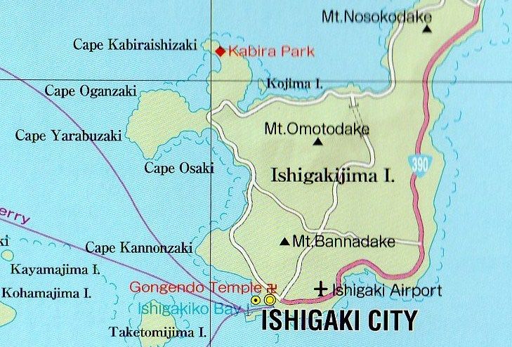
182 Island Sustainability II

1 Introduction
Ishigaki Island (124°9”E, 24°20”N) is located 460 km to the southwest of the
main Okinawa Islands and is the second-largest island of the Yaeyama Island
group. Ishigaki Island, which has a population of approximately 48,000 people
and an area of 223 km2, functions as the political, economic, education and
transport center of the Yaeyama Archipelago. The island is surrounded by the
Pacific Ocean and the East China Sea. The highest point on the island is 526 m
above sea level (ASL) on Mount Omoto. Ishigaki Airport is the largest airport in
the Yaeyama island group and Japan’s largest third-class airport. The airport was
opened in 1943 for military use and converted to a civilian airport in 1956. The
runway was extended from 1,200 m to 1,300 m in 1968. The New Ishigaki
Airport will be opened at another location approximately 10 km to the northeast
of the existing airport in 2014. The runway of the new airport is planned to be
2,000 m-long. Ishigaki Island is blessed with abundant marine resources and
natural environments and it is anticipated that the new airport will increase the
number of tourists visiting the island in the future. Figure 1 shows the Ryukyu
Islands (125°–129°E, 24°–28°N) including the Miyako and Yaeyama island
groups at the southernmost end of the Japanese Archipelago [1].

                                       N
                                                                                  Japan

                                           Ishigaki Island

                                                                          200km

      Figure 1:        Ryukyu Islands (from Wikipedia, the free encyclopedia).

     WIT Transactions on Ecology and The Environment, Vol 166, © 2012 WIT Press
     www.witpress.com, ISSN 1743-3541 (on-line)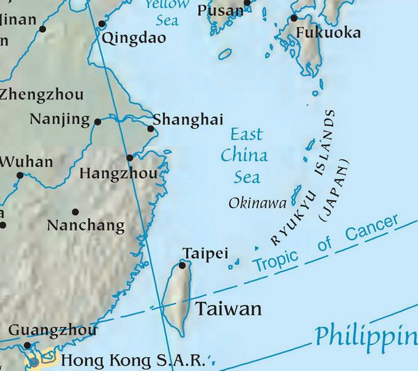
Island Sustainability II   183

2 Yaeyama Islands
The Yaeyama Islands are a group of islands in Okinawa Prefecture, Japan. The
island group consists of 12 inhabited islands (Ishigaki, Taketomi, Kohama, Kuro,
Aragusuku-Kamiji, Aragusuku-Shimoji, Iriomote, Yubu, Hatoma, Hateruma
Kayama and Yonaguni) and three uninhabited islands. The administrative district
of Ishigaki Island is the Ishigaki City, Yonaguni Town is responsible for
Yonaguni Island and Taketomi Town is responsible for the remaining eight
islands. Of the 12 islands, Iriomote and Ishigaki islands are larger than 100 km2;
Iriomote Island is 289.27 km2 and Ishigaki Island is 222.67 km2. The locations of
the Okinawa, the Miyako and Yaeyama island groups within Okinawa Prefecture
are shown in Fig. 2. The longitude and the latitude of each Island are as follows:
Okinawa Islands (128°E, 27°N),Miyako Islands (125.5°E, 25°N), Yaeyama
Islands (124°E, 24°N). The locations of each island in the Yaeyama island group
are shown in Fig. 3. Table 1 shows the areas, populations and number of houses
of each island in the Yaeyama groups. With their tropical atmosphere and laid
back, rural lifestyle, the Yaeyama Islands are a popular getaway destination for
those wishing to escape the hustle and bustle of Japan’s metropolises. This island
paradise offers beaches, snorkeling, diving and relaxation. Of the Yaeyama
Islands, Ishigaki Island is the most populated and serves as the region’s
transportation hub. Other islands include the jungle covered Iriomote Island and
Taketomi Island, famous for its beautifully preserved, traditional Ryukyu village.
Five additional islands comprise the rest of the island chain and offer beaches,
snorkeling and diving [1–3].

                                   N

                                                                  50km

   Figure 2:        Okinawa Prefecture (from Wikipedia, the free encyclopedia).

    WIT Transactions on Ecology and The Environment, Vol 166, © 2012 WIT Press
    www.witpress.com, ISSN 1743-3541 (on-line)
184 Island Sustainability II
Table 1: Area, population, household and administrative center of each
island in Yaeyama Islands [2].
Island Area (km2) Population Household Administrative
center
Ishigaki 222.63 48,089 21,410 Ishigaki City
Ko 0.37 0 0 Ishigaki City
Taketomi 5.42 313 169 Taketomi Town
Iriomote 289.27 2,215 1,153 Taketomi Town
Hatoma 0.96 42 31 Taketomi Town
Yubu 0.16 20 16 Taketomi Town
Kohama 7.84 584 326 Taketomi Town
Kuro 10.02 206 118 Taketomi Town
Aragusuku 1.76 10 9 Taketomi Town
(Kamiji)
Aragusuku 1.58 3 3 Taketomi Town
(Shimoji)
Hateruma 12.77 533 258 Taketomi Town
Uchibanari 2.10 0 0 Taketomi Town
Kayama 0.39 2 1 Taketomi Town
Sotobanari 1.32 0 0 Taketomi Town
Yonaguni 28.91 1,556 766 Yonaguni Town
Total 585.49 53,575 24,559
From Project Bureau, Okinawa Prefecture (2011): Material on isolated
islands [2].
N
20km
Figure 3: Yaeyama Islands (from Wikipedia, the free encyclopedia).
WIT Transactions on Ecology and The Environment, Vol 166, © 2012 WIT Press
www.witpress.com, ISSN 1743-3541 (on-line)Island Sustainability II 185
3 Ishigaki and Iriomote Island
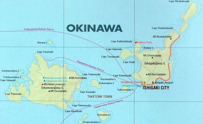
A map of Ishigaki and Iriomote Islands is shown in Fig. 4 [3]. Ishigaki Island is
an island west of Okinawa Archipelago and the second-largest island of the
Yaeyama Island group. The Ishigaki City in Okinawa Prefecture is the business
and transport center of the archipelago. Much of the island and surrounding
waters, including Mount Omotodake and Kabira Bay, are protected as part of
Iriomote-Ishigaki National Park. The Mount of Omotodake in the center of
Ishigaki Island is 526 m ASL. The northern slopes of the mountain are covered
by forest and a coral reef is located to the south of the mountain.
N
10km
Figure 4: Ishigaki and Iriomote Island (from ATRAS JAPAN of Mapple
Press [3]).
Iriomote Island is the largest of the Yaeyama Islands. The total population is
less than 2,000, and infrastructure is limited to a single coastal road connecting
the hamlets on the northern and eastern shores. The island does not have an
airstrip, and most visitors arrive from Ishigaki Island by ferry.
Table 2: Change of population in Ishigaki, Iriomote, Yaeyama Islands and
Okinawa Prefecture [2].
Year 1990 1995 2000 2005 2010
Ishigaki 41,246 41,777 43,302 45183 48,089
Iriomote 1,711 1,887 1,976 2,318 2,235
Yaeyama D. 46,546 47,086 48,705 51,171 53,575
Okinawa P. 1,222,398 1,273,440 1,318,220 1,361,694 1,406,176
WIT Transactions on Ecology and The Environment, Vol 166, © 2012 WIT Press
www.witpress.com, ISSN 1743-3541 (on-line)186 Island Sustainability II
The population of Ishigaki Island, which is increasing on a year-on-year basis
(Table 2), is concentrated to the south of the mountain. Table 2 is the changes of
population in Ishigaki, Iriomote, Yaeyama Islands and Okinawa Prefecture [2].
The climate of Ishigaki Island is tropical and the vegetation is dominated by
tropical forest. Average annual temperature and humidity are approximately
24°C and 77%, respectively, and the average annual precipitation is about 2000
mm. Table 3 shows the average temperature (maximum – minimum), the
average annual precipitation, the hour of sunlight, the average relative humidity
and the average wind velocity from 1971 to 2000 in Ishigaki, Iriomote,
Yonaguni, Naha, Kagoshima and Tokyo [4].
Table 3: Comparison with average temperature (maximum – minimum),
average annual precipitation, annual hours of sunlight, average
humidity and average wind velocity (1971–2000) [4].
Average Average Hours Average Average
Temperature annual of humidity wind
(Max–Min) Precipitation sunlight (%) velocity
(°C) (mm) (hour) (m/s)
Ishigaki 24.0 2,061.0 1,852.6 77 4.7
(26.6–21.9)
Iriomote 23.4 2,342.3 1,536.3 81 4.3
(26.4–20.9)
Yonaguni 23.6 2,363.5 1,577.4 78 6.5
(26.0–21.6)
Naha 22.7 2,036.9 1,820.9 75 5.3
(25.3–20.5)
Kagoshima 18.3 2,279.0 1,918.9 71 3.4
(22.4–14.5)
Tokyo 15.9 1,466.7 1,847.2 57 3.3
(19.7–12.5)
( ):average daily maximum temperature – average daily minimum temperature.
Few forests remain on the island as these have been developed for an
extended period. However, there are numerous valuable organisms as Satakentia
liukiuensis (Japanese name: Yaeyamayashi) and an endemic palm that has been
designated natural monument. In addition, the largest mangrove forest in Japan
can be found at the mouth of the Miyara River in Nagura Anparu, which is a
registered Ramsar site.
In 2005, primary industry on Ishigaki Island accounted for 11.2% of the
economy, secondary industry accounted for 15.7%, and tertiary industries
accounted for 70.7%. For several decades, the number of people engaged in
primary industrial activities on Ishigaki Island and elsewhere on the Ryukyu
archipelago has been decreasing, while the number of workers in tertiary
industrial activities has been increasing. This decrease in the primary industrial
sector is considered to be due to advancing the elimination of labor in the
WIT Transactions on Ecology and The Environment, Vol 166, © 2012 WIT Press
www.witpress.com, ISSN 1743-3541 (on-line)Island Sustainability II 187
enlargement of management area and an increase in mechanization. In addition,
the widening gaps for the other industry and the marked increase in the number
of visitors have drained jobs away from the primary industries to the tertiary
industries. The changes of visitors in Ishigaku, Taketomi, Iriomote Islands is
shown in Table 4 in 1975, 1985, 1995 and 2008 [2].
Table 4: Changes of visitors in 1975–2008 (unit: persons).
Island 1975 1985 1995 2008
Ishigaki 79,000 250,072 446,830 771,106
Taketomi 52,784 80,880 109,269 445,100
Iriomote 42,125 71,405 201,967 384,900
Yaeyama D. 205,438 475,536 864,762 1,902,635
The first Regional Disaster Prevention Plan of Ishigaki City was formulated
by the Local Disaster Management Council of Ishigaki City in 1986. Afterwards
the plan was revised in 1993, 1998 and 2012. Estimation of disaster in relation to
typhoon, earthquake and tsunami based on the past cases was taken in this plan.
Ishigaki Island is frequently struck by typhoons. The dead or the missing
were 4 people in 1977 (Typhoon Bella), and the seriously or slightly injured
were 57 people in 2006 (Typhoon Shanshan). 227 houses were completely or
partially destroyed by Typhoon Bella and 157 houses were completely or
partially destroyed by Typhoon Shanshan. Typhoon disaster in Ishigaki Island is
estimated by these 2 typhoons. Earthquake and Tsunami disaster in Ishigaki
Island is estimated by the Ishigakijima eastward offshore earthquake and the
Ishigakijima southward offshore earthquake. Ishigaki Island was hit by a 40 to
80 m high tsunami in 1771 and about 8,500 people were killed by the tsunami. It
is estimated in the report of earthquake disaster estimation in Okinawa Prefecture
that about 1,500 houses will be completely or partially destroyed and number of
dead, missing and seriously or slightly injured will be about 1,200 people by the
Ishigakijima eastward offshore earthquake and Ishigakijima southward offshore
earthquake. And also, it is estimated in the report that about 1,800 houses will be
completely or partially destroyed and about 6,000 people will be killed or injured
by tsunami of the Ishigakijima eastward earthquake and the Ishigakijima
southward offshore earthquake. The Regional Disaster Prevention Plan of
Ishigaki City revised in 2012 is the disaster plan formulated in regulating of the
Basic Act on Disaster Control Measures (Japanese Government enacted in 1961)
by the Local Disaster Management Council of Ishigaki City. The disaster plan
provides the disaster prevention plan, the disaster first-aid measures plan, the
disaster recovery and reconstruction plan for storm and flood damages,
earthquake, and tsunami. The Communication, Education and Public Awareness
for making these plans known to every citizens is always endeavored by map
exercises and practical trainings on coordinating and cooperating among Ishigaki
City and the organizations.
WIT Transactions on Ecology and The Environment, Vol 166, © 2012 WIT Press
www.witpress.com, ISSN 1743-3541 (on-line)188 Island Sustainability II
4 New Ishigaki Island Airport
The existing Ishigaki Airport was opened in 1943 for military use, and then
converted to a civilian airport in 1956. The runway was extended from 1,200 m
to 1,500 m in 1968 as being stated above. Ishigaki Airport is situated 1.9 km
from the center of Ishigaki Island in Okinawa Prefecture, Japan. The existing
airport essentially serves as the hub of the Yaeyama Zone and conducts flights to
major cities on the Japanese mainland (Tokyo, Osaka, Nagoya, Kobe, Fukuoka)
as well as Naha, Hateruma and Yonaguni in Okinawa Prefecture. The change in
the numbers of passengers and freight handled by Ishigaki Airport is shown in
Table 5 [2]. The departures from Ishigaki Airport don’t contain the freight via
Naha Airport (for examples, Ishigaki – Tokyo, Kansai, Kobe, Itami, Nagoya,
Fukuoka, Hateruma and Yonaguni) in Table 5. Numbers of passengers and
freights have remained at the same level or the tendency to decrease for the past
few years. However, demand forecasting values of New Ishigaki Airport in 2021
are expected to reach at about 2,597,000 passengers and 13,736 freight tonnages
per year [5].
Table 5: Changes in the number of passengers and freight handled by
Ishigaki Airport: upper: passenger (person) lower: freight (ton).
Route Distance 2006year 2007year 2008year 2009year
Ishigaki – 2,171km 163,514 148,400 143,443 133,855
Tokyo 831,646 874,470 706,968 791,961
Ishigaki 1,650km 128,598 92,845 80,430 75,956
– Kansai 443,789 709,190 744,341 551,911
Ishigaki – 1,680km - 65,192 82,983 75,970
Kobe - 51,888 224,603 263,098
Ishigaki – 1,709km 96,057 - - -
Itami 550,029 - - -
Ishigaki – 1,865km 39,961 - 14,907 59,218
Nagoya 94,218 - 22,791 221,128
Ishigaki – 1,307km 41,872 - - 41,796
Fukuoka 113,700 - - 9,400
Naha – 472km 1,358,124 1,438,703 1,408,132 1,199,228
Ishigaki 9,399,357 8,671,799 13,238,476 10,297,859
Miyako – 183km 104,606 88,552 73,869 63,132
Ishigaki 315,530 162,963 177,522 184,467
Ishigaki– 63km 4,701 2,984 - -
Hateruma 7,194 3,472 - -
Ishigaki – 175km 71,943 67,606 68,438 63,724
Yonaguni 322,969 312,330 608,409 114,747
Total 2,009,376 1,904,282 1,872,202 1,712,879
12,078,432 10,786,112 15,723,110 12,434,571
WIT Transactions on Ecology and The Environment, Vol 166, © 2012 WIT Press
www.witpress.com, ISSN 1743-3541 (on-line)Island Sustainability II 189
It is expected that the number of passengers and the volume of airfreight
handled by the airport will increase. However, at present, the transport of
passengers and freight by airplane is dependent on the weather, and container
transportation is complicated by the short, 1,500-m runway. Since it unlikely that
approval from local inhabitants to extend the runway of the existing airport to
2000 m, the existing Ishigaki Airport is serving as a temporary jet airport under
an agreement with local inhabitants. However, a new site is being sought as the
urban area near the existing airport is increasing and aircraft noise currently
exceeds environmental standards. Consequently, in 1999, the construction of a
new Ishigaki Airport was proposed by a committee established to find a new
location for the new Ishigaki Airport, and an allocation has unofficially been
made in the budget of the Japanese government for the new Ishigaki Airport at a
new site about 15 km from the city of Ishigaki as shown in Fig. 5.
Shiraho
coral
New Airport
Figure 5: Sites of existing Ishigaki Airport and new Ishigaki Airport. (From
ATRAS JAPAN of Mapple Press [3].)
It is considered that approximately 90% of the inhabitants of Ishigaki and the
towns of Taketomi and Yonaguni will be involved in the construction of the New
Ishigaki Airport. Approximately 80% of local inhabitants agree with the site
inhabitants are concerned about issues such as nature and soil conservation that
would be associated with the airport. In future, it will be expected by inhabitants
of islands that the industry is developed by the increase of freight and the
economy is has been picked up by the increase of tourists. With a 2,000-m
runway, the new Ishigaki Airport will be capable of servicing mid-sized jet
airplanes. The new airport will be constructed 31 m ASL, which is considered to
be sufficiently high for protection from tsunamis or tidal waves. The
WIT Transactions on Ecology and The Environment, Vol 166, © 2012 WIT Press
www.witpress.com, ISSN 1743-3541 (on-line)190 Island Sustainability II
construction site is near the Shiraho coral reef, which is about 10 km long and 1
km wide [6].
Initial plans for the New Ishigaki Airport made in 1979 were to construct the
airport on landfill of the Shiraho coral reef, but the plan was canceled in 1989
due to the drastic opposition by environmentalists of outsider. After several
alternate proposals, it was finally decided to construct the New Ishigaki Airport
on land in the vicinity of Karadake Mountain in northern Shiraho. The new plan
involves the construction of a containment dam to prevent the runoff of red clay
from entering the sea. The New Ishigaki Airport is due to be opened in 2014. It
is estimated that, after 50 years, the cost-benefit effect of the New Ishikari
Airport will be 1.7. This can be calculated by adding the profits derived from
users of the airport (492 billion yen) to those from suppliers (132 billion yen),
and dividing it by the cost of construction, site acquisition and maintenance,
improvements, etc.( 374 billion yen) and is shown in the relation : (492 + 132)
/374 = 1.7.
The environmental preservation measure is a challenge of New Ishigaki
Airport. Various plants and animals of natural monument inhabit and grow in the
neighboring area of New Ishigaki Airport. And the coral reef is spreading in the
neighboring waters of New Ishigaki Airport. The environmental examination
committee, the construction method examination committee and the examination
committee of small bat kinds composed by literates, nature conservation groups,
etc. were constituted for the environmental impact assessment, so that the
environmental preservation measures of monitoring, evasion, reduction, etc.
were planned and executed by the guidance and advice of those experts [7].
5 Conclusions
The 1972 reversion of Okinawa to Japan came with a price – the continued use
by the United States of sprawling military bases and other facilities in the
prefecture to protect Japan and maintain peace in the Asia-Pacific region [8].
The Yaeyama island chain, including Ishigaki Island in Okinawa Prefecture, is
blessed with abundant natural resources, good weather, agricultural products,
and marine products. It is considered that the tourist and travel industries will
increase as more people become aware of the diversity of natural environments,
as well as the many sites of historical, cultural and geographic interest in
southwestern Japan. Ishigaki Island is the main island of the Yaeyama Islands
and serves the region’s transportation hub. Ishigaki City is the Yaeyama’s only
urban center and is the site of the region’s major airport and boat terminal. The
construction of the New Ishigaki Airport is expected to have a beneficial effect
on the economy and development of Ishigaki Island and the surrounding islands.
References
[1] Wikipedia, The free encyclopedia, Yaeyama Islands,
http://en.wikipedia.org/wiki/Yaeyama-Islands, 2012.
[2] Project Bureau, Okinawa Prefecture: Material on isolated islands, 2011.
WIT Transactions on Ecology and The Environment, Vol 166, © 2012 WIT Press
www.witpress.com, ISSN 1743-3541 (on-line)Island Sustainability II 191
[3] Mapple, ATRAS JAPAN, Shobun Co. Ltd, 2010.
[4] Yaeyama Branch Office, Okinawa Prefecture: Manual Yaeyama, 2009.
[5] Okinawa Prefecture, Transport performance and demand forecast in the
New Ishigaki Airport, http://www.pref.okonawa.jp/shin-ishigaki
/yusoujituseki.html, 2012.
[6] New Ishigaki Airport Division, On the New Ishigaki
Airport,http://www.pref.0kinawa.jp/shin-ishigaki/newishigaki/index.html,
2012.
[7] Cabinet Office of Japanese Government, Maintenance of New Ishigaki
Airport, http://www8.cao.go.jp/okinawa/5/57.html, 2012.
[8] The Japan Times, Okinawa still at forefront of defense plans, May 16, 2012.
WIT Transactions on Ecology and The Environment, Vol 166, © 2012 WIT Press
www.witpress.com, ISSN 1743-3541 (on-line)You can also read