Dark Peak Forest Plan 2017 to 2027 - Forestry Commission England
←
→
Page content transcription
If your browser does not render page correctly, please read the page content below
Dark Peak Forest Plan 2017 to 2027

Dark Peak Forest Plan 2017-2027
Summary
Forestry Operations 2016 to 2027
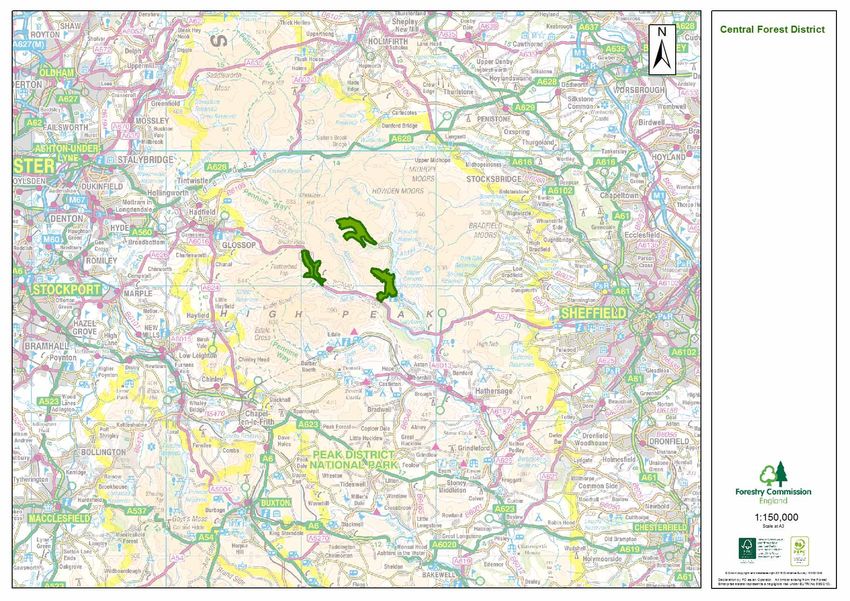
The Dark Peak Forest Plan (FP) summaries proposals by the Forestry Commission for the
management of three woodlands, Snake (154.2ha), Lockerbrook (191ha) and Westend
(240.2ha) which lie in the Peak District National Park, Derbyshire. The plan area of 585.4ha
lies mid-way between Glossop and Sheffield adjacent to the A57, Ladybower and Derwent Woodland Grid Refer- Total Area Felling (ha) Restocking, Natural Open Space
Name ence (ha) Regeneration & En-
Reservoir. richment planting (ha)
The woodlands are dominated by productive mature conifer forest much of which is 70-90 Snake SK 109 910 154.2 29.2 27.9 1.3
years old and ready for harvesting. The new management plans objectives will be to
continue to grow commercial crops on a sustainable basis, diversify the forest structure Lockerbrook SK 140 945 191 23.9 22.2 1.7
through harvesting operations, restore native clough woodland, expand the woodland
boundaries to develop move open mixed stands designed to increase unity with open
Westend SK 165 900 240.2 24.2 37
moorland and show an increase in visual ‘naturalness’ in the long term.
The principal ecological interest in the plan area is a combination of moorland, native
woodland habitats and fauna associated with it. The FP will help to develop a wider range of
woodland habitats through active forest management. This will be achieved specifically
through the retention of some strands of trees in perpetuity, the development of mixed open
stands along water courses and the interface with the surrounding open moorland,
restoration of clough woodland and increased length of woodland edge habitat. Recent
felling operations have already begun to increase the available nesting site for birds.
The Forestry Commission will continue to provide open access throughout all of the FP
woodlands to the millions of visitors who come into the National Park each year. The two
waymarked trails will be maintained and the woodland management adjacent to these will be
carried out at an appropriate scale.
1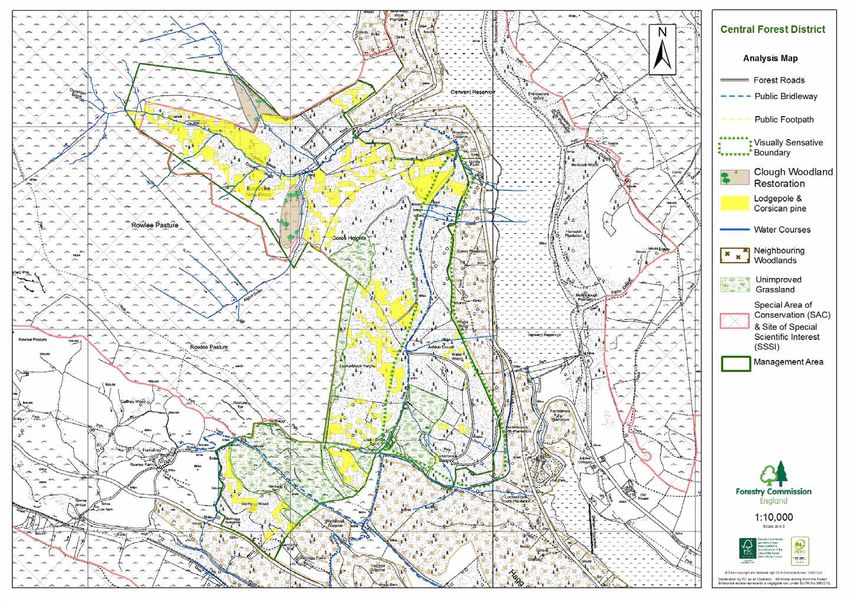
Dark Peak Forest Plan 2017-2027

Contents:                                                          Page No.            Contents:                                                          Page No.
       Summary                                                        1                6.   Consultees                                                       14
A      What are Forest Plans                                          3                7.   Glossary                                                         15
B      Application for Forest Plan Approval
1.     Introduction                                                   4                     Maps
       Fig 1    Forestry Commission England’s Planning Strategy                                    Location Map                                              17
1.1    Dark Peak FP – Survey Data                                     5                            Roads & Access                                            18
       Fig.2 Age Structure                                                                         Ecological & Cultural Interests                           19
       Pic.1. View of the north side of Snake Pass in the valley                                   Current Species                                           20
       and open moorland on the Plateau.                                                           Elevation & Landform                                      21
2.     Management Objectives                                          6                            Analysis Map – Snake                                      22
3.     Forest Plan Objectives                                                                      Concept Map – Snake                                       23
3.1    Woodland                                                                                    Analysis Map – Lockerbrook                                24
       Pic.2. Clough Woodland restoration in Lockerbrook                                           Concept Map – Lockerbrook                                 25
       Fig.3 Current Species                                          7                            Analysis Map – Westend                                    26
       Table.1 Current Species                                                                     Concept Map – Westend                                     27
3.2    Environmental                                                                               Silvicultural Systems Map                                 28
       Pic.4. Snake 2016 – High Forest adjacent to watercourse        8                            Felling Map - Snake                                      30
       with no understory                                                                          Future Land Use - Snake                                  31
3.3    Open Habitats                                                                               Felling Map – Lockerbrook                                32
3.3.1 Sites of Special Scientific Interest (SSSI)                                                  Future Land Use – Lockerbrook                            33
3.3.2 Unimproved Grassland                                            9                            Felling Map - Westend                                    34
3.3.3 Acidic Grassland                                                                             Future Land Use - Westend                                35
3.4    Social                                                                                      View Point 1—Snake Pass looking south                    36
3.5    Harvesting                                                                                  View Point 2—Snake Pass looking north                    37
       Table 2.—Annual Production forecast volume m³ within each felling period.                   View Point 3—Lockebrook from Ladybower reservoir         38
3.5.1 Restocking and Future Management                                                             View Ponit 4—Lockebrook from Derwent reservoir           39
       Pic.5. Example of irregular tree line to be created when                                    View Point 5—View south of Westernd                      40
       restocking take place                                                                Appendix I – Forest Plan Brief                                  41
Pic.5 Example of future upper tree line                               10                    Appendix II – Lockerbrook Vegetation Monitoring report 2015     42
       Table.3 Future Species Composition – 2066                                            Appendix III – Lockerbrook Bird Survey 2015-16                  44
       Fig.4 Current and Future Forest Structure                      11                    Appendix IV – Westend Bird Survey 2013                          45
4.     Meeting and Monitoring Management Objectives                                2        Appendix V –          Westend Botanical Survey 2013              46
5.    2017 Forest Plan comparison against the 2001/02 Forest Plans    13
Dark Peak Forest Plan 2017-2027

1. What are Forest Plans?                                                                                A     Application for Forest Plan Approval

Forest Plans are produced by us, the Forestry Commission (FC), as a means of
                                                                                                         i     Plan Area Identification:
communicating our management intentions to a range of stakeholders. They aim to fulfil a
number of objectives:
                                                                                                                Forest District:                      Central Forest District
• To provide descriptions of our woodlands to show what they are like now.
                                                                                                                Beat:                                 Peak District
• To explain the process we go through in deciding what is best for the woodlands’ long-term
                                                                                                                Name:                                 Dark Peak Forest Plan
future.
                                                                                                                Nearest Town:                         Hope Forest
• To show what we intend the woodlands to look like in the future.
                                                                                                                OS Grid Reference:                    Snake              SK 109 910
• To detail our management proposals, for the first ten years so we can seek approval from
                                                                                                                                                      Lockerbrook        SK 140 945
the statutory regulators.
                                                                                                                                                      West End           SK 165 900
Our aim is to produce a plan that balances the publics needs with wildlife and meets our
                                                                                                                Local Planning Authority              Peak District National Park
management objectives.
We have produced this draft plan to illustrate our management proposals thereby creating
                                                                                                         ii    Designations:
an opportunity for you to comment on the plan, whether you are a user, a neighbour or a
                                                                                                                National Park, Special Area of Conservation (SAC), Site of Special Scientific Interest
member of one of the many stakeholder groups that have an interest in the woodlands.                            (SSSI), and lies within the Dark Peak Natural Character Area, Profile No.51,
                                                                                                                Secondary Woodlands, Clough Woodland.
Information on how to get your comments to us is on our webpage.
This plan does not set out the detailed yearly management operations for each small piece                iii   Date of Commencement of Plan
of a wood, known as a coupe*. It is not possible to say which year a particular operation will                  As soon as possible once approved.
take place, but we can say in which five-year period it should happen.
                                                                                                                              Area (ha)               Conifers         Broadleaves
All tree felling in the UK is regulated and a licence is required before trees can be felled; the                       Felling *                       76                  0
scale of tree felling in Central England Forest District, which this plan forms part of, is such
that the Forest Plan is the best mechanism for applying for this licence.                                               Restocking **                    55                     33

Responsibility for checking that the plan meets all the relevant standards and statutes lies
                                                                                                                        Low Impact Silvicul-             10                     1
with another part of the FC (Forest Services). If all the criteria are met, full approval is given
                                                                                                                        tural Systems
for the management operations in the first ten years (2017 - 2027) and outline approval for
                                                                                                                        (LISS) ***
the medium term vision (2027 - 2066). The plan will be reviewed after the first five years
(2021) to assess if the objectives are being achieved.                                                          NB all above figure’s refer to the gross area

We use some technical words and phrases in the text because they best describe what we
are doing. There is a glossary at the back of the plan with some commonly used technical                 * Excludes thinning operations that take place on a 5 year cycle in conifers and 10 year

forestry terms and abbreviations. These technical words are identified with an *.                        cycle in broadleaves.
                                                                                                         ** The restocking will be through a combination of restocking, natural regeneration and
                                                                                                         enrichment planting to reach full stocking in areas to be manged as productive high forest.
                                                                                                     3
                                                                                                         *** Refers to the net area of felling that may take place in the next 10 years.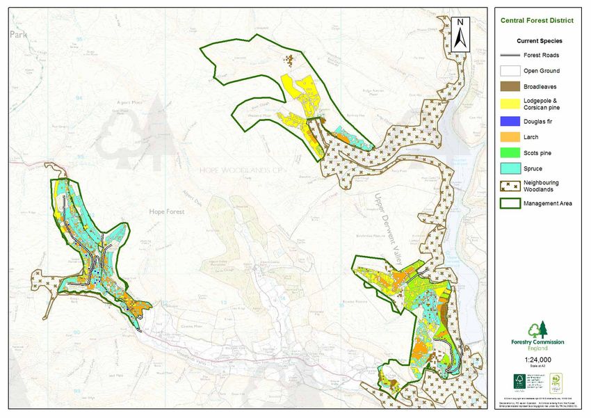
Dark Peak Forest Plan 2017-2027

        ** The restocking will be through a combination of restocking, natural regeneration         Fig 1. Forestry Commission England’s Planning Strategy
        and enrichment planting to reach full stocking in areas to be manged as productive
        high forest.
                                                                                                                                       National Forest Policy
        *** Refers to the net area of felling that may take place in the next 10 years.

                                                                                                                             The FC sets out its vision and aims for For-
        Total felling operation 87ha                                                                                         estry in England at a national level. This is
                                                                                                                             outlined in the Strategic Plan for the Public
        Forest Plan maps are attached

I apply for Forest Plan approval for the area described above and in the enclosed Forest
Plan.
                                                                                                                                   Forest District Strategic Plan
I undertake to obtain any permission necessary for the implementation of the approved plan.

                                                                                                                             The District Strategic plan sits between the
Signed ……………………………                           Approved …………………………                                                             national and local planning levels and sup-
                                                                                                                             ports the aims and objectives within the
                                                                                                                             districts, according to the FE England Na-
          FDM                                                                                                                tional Policy and gives direction for the

District …..………………………..                      Conservancy ……………………….

Date     ……………………………                         Date         …………………………
                                                                                                                                            Forest Plans

1. Introduction                                                                                                              Forest Plans are used by the FC to demon-
                                                                                                                             strate sustainable forest management on
                                                                                                                             the public estate in the long term and to
This Forest Plan (FP) is updating two older FP’s prepared in 2001/2002 and provides                                          define a 10 year programme of approved
                                                                                                                             work. They explain how a local area of
approval for felling and restocking over the next 10 years and sets out our management                                       forest will be managed and why and is pro-
                                                                                                                             duced in consultation with internal and
proposals for the next fifty years. FP’s are operational plans and although they do take into                                external stakeholders, and following
account the presence of social and environmental features, their management will be dealt
with in separate documentation.

This FP is guided and directed by a number of policies and strategies - the main documents
                                                                                                                                  Operational Site Plans (Ops 1’s)
are summarised in Fig.1. Delivering this plan will require the Forestry Commission (FC) to
be responsive to shifts in our operating environment and increasingly flexible in our
                                                                                                                             Management plan for specific operations
approach, and to sustain this responsiveness over decades to come.                                                           on site, undertaken in accordance with the
                                                                                                4                            above and by following national guidance
              Protecting and Expanding England’s Forests and Woodlands and Increasing their
                                  Value to Society and the Environment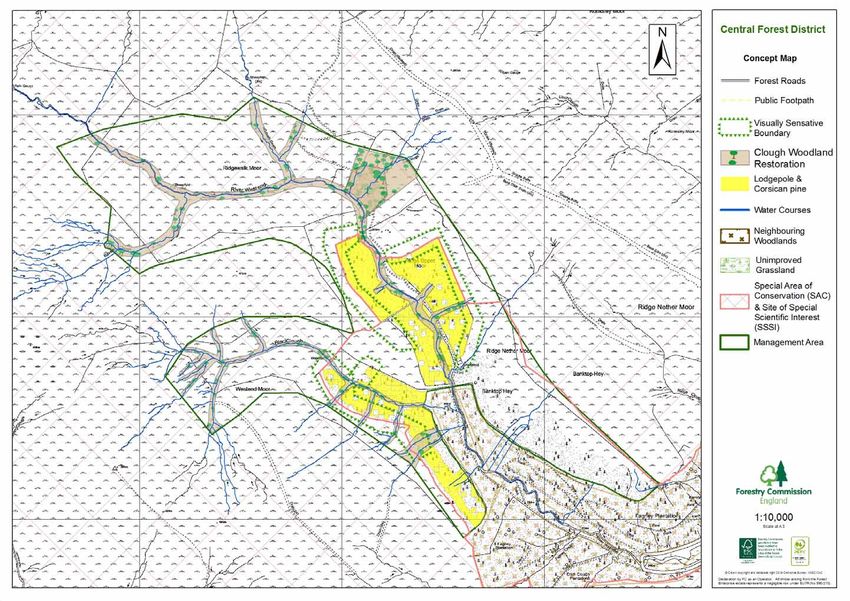
Dark Peak Forest Plan 2017-2027

1.1. Dark Peak FP – Survey Data                                                                   The dominant local landscape character is of wild moorland, interspersed with clough
                                                                                                  woodland around streams and minor rivers, with extensive woodlands, mainly of plantation
The Dark Peak Forest Plan (585.4ha) comprises three woodlands, Snake (154.2ha),                   origin on lower slopes and adjacent to the reservoirs. Large areas of the forest plan (FP) lie
Lockerbrook (191ha) and Westend (240.2ha) which lie in the Peak District National Park and        on steep valley sides making the woodlands strong features in the local landscape but less
form part of the Dark Peak and Upper Derwent catchment, Derbyshire. The plan area of              visible in the wider landscape Pic.1. Lockerbrook and Westend adjoin non-FC woodlands
585.4ha comprises 53% high forest and 47% open space which is largely moorland and                which isolates them from the reservoirs and public roads making them less apparent in the
rough grazing.                                                                                    landscape as individual features. Snake Forest stands alone and despite recent woodland
                                                                                                  creation projects on neighbouring land the forest is a major standalone feature in the local
The woodlands were planted between 1930 and 1980 with Snake and Westend comprising                landscape. Principal views are from the public roads in the valley bottom. The woodlands
more uniform mature stands and Lockerbrook having a more mixed age structure, see Fig1.           are predominantly coniferous but contain some native broadleaved elements.
Commercial species are mainly Lodgepole pine, Sitka spruce, Hybrid and Japanese larch.
Spruce and larch are the most productive species with prolific natural regeneration of both       There are no public facilities within the forests and public access is currently low to medium
species occurring on recently felled sites and under some more open mature stands. The            despite high visitor numbers into the Derwent Valley and Peak District National Park.
Lodgepole pine has been badly affected by Dothistroma Needle Blight (DNB) a fungal                Parking is available at Snake Pass in Birch Clough layby on the A57 where there are
pathogen that affects tree growth through defoliation which significantly reducing timber         interpretation boards and the start of waymarked trails. There is no parking provision
yields. It can also eventually lead to mortality. Corsican and Scots pine have also become        adjacent to Lockerbrook or Westend although public laybys and Seven Trent Water car
infected by DNB but the impact currently has not been as great.                                   parks are available nearby.

Fig 2.                                                                                            The FP lies adjacent to the A57 that runs between Sheffield (13 miles) to the east and
                                                                                                  Glossop (4 miles) and Manchester (15miles) to the west.

                                                                                              5                        Pic.1 View of northern side of Snake Woodland in
                                                                                                                            the valley and open moorland on plateau.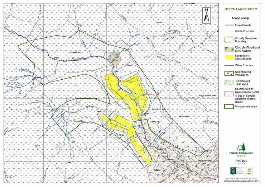
Dark Peak Forest Plan 2017-2027

2. Management Objectives                                                                                A principle management objective for the woodlands will be the continued production of
                                                                                                        sustainable timber resources. This will be delivered through a harvesting programme based
                                                                                                        on clearfells and Low Impact Silvicultural Systems (LISS). Clearfelling has been the
                                                                                                        preferred method on steeper ground and LISS have been used on level, fertile well drained
                                                                                                        soils and buffer zones, see silvicultural map. The size, shape, scale and timing of
                    The continued production of            The conservation,
                                                                                                        management operation have been designed in keeping with the landscape character of the
                    sustainable and marketable              maintenance and enhancement
                    woodland products to include             of cultural and heritage assets.           area and provide the most suitable conditions to diversify the forest structure and establish
                    infrastructure requirements.                                                        future stands. To enable these planned operations a number of new forest tracks will need
                                                                                                        to be created to allow access for forest machinery, see Access Map.
                                                                          The provision and
                                              The delivery of
                                                                          maintenance of
      Improve species diversity                well-designed
                                                                          recreation facilities.        The creation and restoration of
      and silvicultural techniques             proposals that
      to regenerate commercially                                          Support the development of    clough woodlands will be a part
                                                comply with
      productive but more structurally                                    increased recreation
                                             landscape design                                           of the new FP and will build
      and species diverse resilient crops.                                provision in The National
                                                 principles
                                                                          Forest.                       upon the Forestry Commissions
                                                                          Improve stand resilience
                                                                                                        (FC) restoration projects that
                                                                          around recreation
                                                                          infrastructure.               have taken place over the last
                                                                                                        15 years, see Current Species
                                                                                                        and Future Landuse maps. This
                         Recruitment of Trees of         Diversity habitats to increase                 has been achieved on open
                                                                                                                                                   Pic 2. Woodland restoration in Cote Clough
                         Special Interest (TSI) and      feeding and breading
                                                                                                        ground through the introduction
                         increase deadwood habitat.      habitats for wildlife.
                                                                                                        of stock fencing to exclude
                                                                                                        sheep and the planting of individual plants of native species within the cloughs, Pic.2. Within
                                                                                                        the existing high forest clough restoration will take place when adjacent stands are felled.
                                                                                                        These areas will be left open and any existing broadleaves retained to provide seed source,
                                                                                                        see Future Landuse maps.

                                                                                                        The threat to timber production from climate change and more directly from pest and
3.0       Forest Plan Objectives                                                                        diseases (DNB) is already having a major impact in the forests, with Lodgepole and
3.1 Woodland                                                                                            Corsican pine having been worst affected Pic.3. Phytophthora ramorum is a notifiable
Snake Forest was planted between 1928 and 1930 and Lockerbrook and Westend Forests                      disease affecting larch and although not currently present in the FP forests it is in the region.
between 1943 through to the early 1960’s and are now dominated by mature conifer stands.                To ensure long-term sustainable timber production, the present tree species will be
Limited felling has taken place over the last 30 years and this has created some structural             diversified in future rotations selecting species that are more resistant to the current and
diversity within the woodlands and this will be expanded further through the felling proposals         6 increased incidence of pests and disease. Where natural regeneration is used to restock
in this FP.                                                                                             sites
Dark Peak Forest Plan 2017-2027

enrichment planting will take place to allow for the introduction of alternative species.        Due to the steep topography in parts of each forests and the wet peat soils on Lockerbrook
Lodgepole pine will be targeted where possible for early removal in the future harvesting        plateau some stands have been and will continue to be managed as non thin crops, see
programme due to the effect of DNB.                                                              silvicultural map. The last rotation of conifers has shown that stand stability is not an issue
                                                                                                 despite the forests exposed elevated location and most conifer stands will continue to be
Fig.3 Current Species within Dark Peak Forest Plan                                               thinned every five years, ten years for broadleaves where terrain allows.

                                                                                                 3.2 Environmental
                                                                                                 The FP lies within the Dark Peak Natural Area with the moorlands being designated as
                                                                                                 Special Conservation Areas (SAC) and Sites of Special Scientific Interest (SSSI). It is an
                                                                                                 upland area of international importance supporting a wide variety of breeding moorland and
                                                                                                 moorland fringe birds and invertebrates. Deeply-incised cloughs with fast flowing steams
                                                                                                 run down the steep hillside, through the forests and into the valleys where the River Ashop
                                                                                                 feeds into the Derwent reservoir which provides clean drinking water for cities in Yorkshire
                                                                                                 and the East Mildands.

                                                                                                 The mixture of forest, moorland, rough grassland and water feature found within the FP area
                                                                                                 provide a valuable habitat resource within the wider landscape. The current forest structure
                                                                                                 and woodland edge habitats are limited due to the mature stand structure but despite this
                                                                                                 bird surveys carried out over the last 3 years have recorded a wide variety of species, see
                                                                                                 Appendix II. Recommendations from the report identified a lack of nesting sites and
                                                                                                 measures have been introduced to create artificial nesting sites and through the planned
                                                                                                 harvesting operations more natural nesting sites will become widespread across the FP
                                                                                                 area. The introduction of LISS in the Snake and the south western edge of Lockerbrook will
Table 1. Current Species
                                                                                                 help create a more diverse internal stand structure. This along with the shape, scale and
                                                        Locker-                   Percent-
                           West End        Snake         brook        Hectare       age          timing of clearfells will provide more diverse habitats with varied canopy levels, and
   Open Space & Agri        191.0           28.4          55.5         274.9       47.0          transitional open space following felling operations that will increase further the available
   Broadleaves               2.6            2.1           16.0          20.7        3.5
                                                                                                 woodland habitats for wildlife. The edge of the forests and moorland will be modified by a
   Sitka Spruce                8.8          59.0          29.0          96.8         16.5        combination of techniques to protect individual and groups of trees and reduce or remove
   Evergreen conifers                       5.5           5.2           10.7          1.8        grazing pressure. Subsequently when coupes are felled and restocking takes places the
   Scots pine                  0.6          0.1           32.8          33.5          5.7
   Corsican & Lodge-                                                                             new stands will comprise a variety of species at different densities. This means that when
   pole pine                  33.3          12.2           34.6         80.1        13.7         they reach maturity they will not create a strong linear feature on the horizon when viewed
   Larch                      3.8           26.8           14.9         45.5         7.8     7
                                                                                                 from the surrounding open moorland. The edge of the new tree line will incorporate deep
   Restock                    0.0           20.0           3.0          23.0         3.9
   Grand Total               240.1         154.1          191.0        585.2        100.0        irregular lines running up and down the hill side (cloughs) which will create a more natural
Dark Peak Forest Plan 2017-2027
woodland edge and interface with the open moorland with broadleaves Pic.5. This will also There are currently very few veteran trees within the FP area and the only deadwood
provide space for broadleaves to become established within the conifer stands and then for habitats are associated to some patches of small diameter conifers that have died within the
a more open mixed stand to become established along the woodland edge and into the current stands. Through the introduction of LISS and the over mature nature of some of the
adjacent moorland. In practice it is anticipated that there will be a continuum from closed conifer stands individual and small groups of trees will be retained in perpetuity to create
canopy conifer plantation woodland through broadleaved high forest, open canopied future veteran trees and standing deadwood. When felling operations take place any dead
woodland to open moorland. This will standing snags will be retained.
provide valuable cover for wildlife and
nesting sites for birds. Bird surveys 3.3 Open Habitats
will continue to help monitor the 3.3.1 SSSI – over 50% of the Westend area, and minor areas at the Snake and
impact of the change in forest Lockerbrook are designated as part of the Dark Peak SSSI.
structure over time, Appendix I. Additional European designations concurrent with the SSSI are:
The FP lies within the water catchment South Pennines SAC, designated for:
for the Derwent reservoir and buffers Blanket bogs
will be established along the European dry heaths
numerous water courses that pass Pic.4. Snake 2016 - High forest adjacent to Northern Atlantic wet heaths with Erica tetralix. (Wet heathland with cross-leaved heath)
through the forests in accordance with watercourse with no understory. Old sessile oak woods with Ilex and Blechnum in the British Isles. (Western acidic oak
the Forestry and Water guidelines woodland)
Pic.4. Where conifer stands abut streams they will be gradually opened up when thinning Transition mires and quaking bogs
operations take place to create space for broadleaves to become established prior to the
main conifer stands being removed. The tree line adjacent to the aquatic and riparian zones South Pennine Moors SPA, designated for:
will be carefully managed to allow the creation of dappled shade, open clearings and the Merlin
development of associated vegetation. When coupes are clearfelled appropriate measures European Golden Plover
will be taken to reduce the risk of siltation and aid soil stability . These are not shown on the Breeding Bird Assemblage
felling map due to the landscape scale of the plan but will be picked up on the coupe plans
drawn up by the beat forester and agreed by district management team prior to any forestry The management of these areas is covered in more detail in the Dark Peak SSSI
operations being carried out. Management Plan, but in summary the majority of the SSSI in Westend will be covered by a
grazing agreement with a tenant farmer. The livestock stocking density will be agreed with
Clough woodland restoration has already begun in Cote Clough, Lockerbrook (2005) and Natural England, and the tenant may enter into subsequent agri-environment schemes with
Dry Clough Westend (2000) and this will be expanded to include a number of valleys within the agreement of all parties. Both within and without these grazed areas, native
Snake and Lockerbrook forest and the open moorland to the west of Westend, Pic.2. The broadleaved woodland will be established in the cloughs and valley sides, at varying
clough woodlands will be managed through LISS with conservation being a major part of the densities.
management objectives for these areas. 8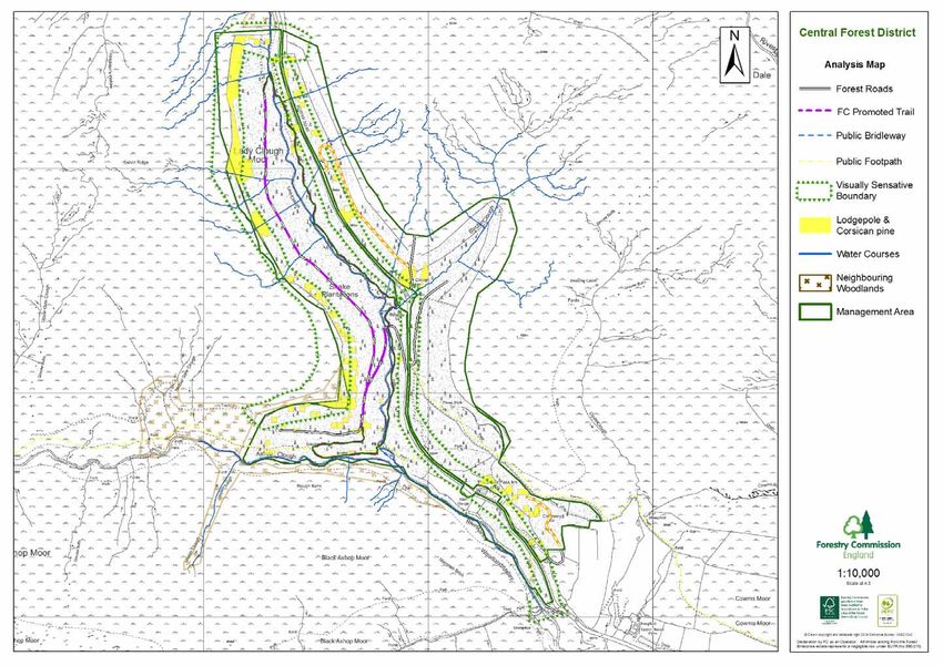
Dark Peak Forest Plan 2017-2027

3.3.2 Unimproved grassland – this type of grassland, often called In-bye, is common in the          There are no Scheduled Ancient Monuments in the plan area but the 1997 archaeological
South Pennine area. In-bye consists of unimproved and semi-improved grassland, and is               survey (Bevan, Upper Derwent Archaeological Survey: Snake Plantations) identified a
often associated with wet, rushy or boggy areas, adjacent to, or close to unenclosed                number of archaeological features in the plan area. These are catalogued in the Survey
moorland. Within the FP there are two discrete areas of this type of grassland, above Bell          Report 1997/98 and include trackways, revetments and built structures. The most notable
Hagg Wood and at Lockerbrook Farm. Both areas are grazed by sheep and cattle, and                   feature in the area is the dam overlooked from Lockerbrook which was used by 617
there are restrictions in the lease on ploughing up existing grassland and application of           Dambuster Sqd to train in World War II with the bouncing bomb.
fertilisers.

                                                                                                    3.5 Harvesting
3.3.3 Acidic grassland – this is approximately 10ha of grassland on the moorland edge
                                                                                                    The proposed harvesting programme will generate approximately 78,000m³ of timber over
consisting of Molinia and Nardus communities with some ericoid species, graduating to a
                                                                                                    the next 50 years. This is similar to the old plan but with a greater volume of timber been
more in-bye type of acid grassland on the lower areas. Since 2010 this area has been
                                                                                                    removed in the first 20 years due to disease and wind damage. There is a slight reduction in
grazed by cattle, mostly in the summer months, in an attempt break up the extensive Molinia
                                                                                                    timber to be harvested and this is partly due to the increased use of LISS as apposed to
and Nardus beds to improve the floristic diversity. Surveys have taken place since 2009 to
                                                                                                    clearfelling the current stands when they reach economic maturity. To ensure the future
monitor the changes in vegetation (see Appendix II).
                                                                                                    harvesting programmes can be undertaken in in each of the woodlands a number of new
                                                                                                    forest road will be created following survey by our Civil Engineers, Environmental Impact
3.4 Social
                                                                                                    Assessment (EIA) and planning approval.
The Peak National Park experiences over 22 million day visits per year and has a strong
                                                                                                                       Forecast Period    All Species    All Conifers    All Broadleaves
association with the right to roam and the access movement. Tourism today also plays and
                                                                                                                       2017‐2021                  3184            3101               83
important part in the local economy through the Dark Peak’s ease of access from cities and                             2022‐2026                  2738            2698               40
large towns. The moorlands surrounding the plan area are the subject of an Access                                      2027‐2031                  2216            2175               41
                                                                                                                       2032‐2036                  1616            1485              131
Agreement which allows free public access at all times. Coupled with the FC open access
                                                                                                                       2037‐2041                  1669            1635               34
policy, the entire plan area is available for informal recreational use. There are no visitor                          2042‐2046                  2104            2048               56
facilities within the woodlands but there is one bridleway which cuts through the Lockerbrook                          2047‐2051                   618             595               23
                                                                                                                       2052‐2056                   657             628               29
woodlands and a public footpath in Snake Forest. General use is for the purpose of access                              2057‐2061                   965             945               20
between the reservoirs and open moorland. There are several waymarked trails, two in                                   2062‐2099                  1432            1394               38

Lady Clough which is part of Snake Forest and one circular waymarked trail in Lockerbrook,
                                                                                                    Table 2.—Annual Production forecast volume m³ within each felling period.
promoted by Peak District National Park Authority (PDNPA). Seven Trent Water has a
visitor centre and public facilities at Ladybower Reservoir close by. There are no plans to
                                                                                                    3.5.1 Restocking and Future Management
provide public facilities within the FP woodlands but consideration for public rights of way
                                                                                                    The current forest composition will change quite markedly over the next rotation moving
and informal access points have been included in the design proposals. The plans
                                                                                                    away from pure conifer high forest to a combination of conifer, broadleaves and mixed
proposals to use LISS in valley bottoms and along water courses where some of the
                                                                                                    conifer / broadleaved stands. Within the forests the pattern and distribution of species will
promoted routes lie which will allow individual character trees to be retained in perpetuity
                                                                                                    vary. Broadleaves will dominate in the buffer / riparian zones with some individual and small
and a more varied open mixed woodland to develop that will increase the aesthetic value of      9
                                                                                                    groups of conifers being retained for their aesthetic and biodiversity value. Conifers will be
the forests to visitors.
                                                                                                    the most abundant species on the lower to mid slope moving into conifer / broadleaved
Dark Peak Forest Plan 2017-2027
mixtures higher up the slopes. On the edge of the forests broadleaves will become more
prevalent creating mixed stands within the current area of forest and small groups and
individual trees will be established in the surrounding moorland valleys. This will create a
more natural interface between the open moorland and high forest. Through the exclusion
of grazing in the south-east half of Westend, complemented by some enrichment planting,
the areas of open heathland will be diversified by the introduction of some tree cover that will
soften the landscape appearance of the conifer stands and diversify the ecological niches
available in the adjacent heathland.
Restocking will be through a combination of natural regeneration in both clearfell and LISS
coupes with enrichment and standard planting used to introduce a more diverse mixture of
species and achieve appropriate stocking densities.
Pic.5 Example of future upper tree line moving through from conifers
Sites due to be restocked will be assessed to select the most appropriate species that will be to mixed woodland to open woodland.
best adapted to the site conditions (soils and aspect) and the impacts of any future climate
change, whilst maintaining species diversity. No one species will dominate the future forest
structure and a wider variety of species will gradually become established over the next 50
Table 2 Future Species Composition – 2065
years including some mixed stands. The combination of clear fell sites (restock) and LISS
(underplanting) will provide ideal microclimates for pioneer species (light demanders) and
late successional species (shade tolerant species) to establish successfully throughout the
Habitat Hectare Percentage
FP.
Open Moorland and Agriculture 235 40
The new species that will be used to diversify the forest will be increasingly palatable to Open Moorland with some Broadleaves 32 5
mammals and a greater level of protection may be needed to ensure successful Broadleaves 12 2
establishment and a combination of mammal control and fencing will be used to achieve this. Mixed stand dominated by Broadleaves 13 2
Clough Woodland 37 6
Mixed stand dominated by conifers 108 18
Conifers 147 25
10Dark Peak Forest Plan 2017-2027
Fig.4 Current / Future Forest Structure
4. Meeting and Monitoring Management Objectives
Woodland The woodlands will be Conifer stands will be managed Monitored
managed to produce using a combination of clearfell through Sub-
commercial conifer and LISS based on topography compartment
and broadleaf timber and landscape considerations. database.
using a variety of Crops will generally be thinned
silvicultural systems on a 5 year rotation with the
which will be chosen exception of the peat soils on
to aid establishment. Lockerbrook plateau and the
steepest sections of Snake
Forest where crops will be left
un-thinned
Broadleaf stands will generally
be managed as high forest
using a LISS to produce quality
timber and thinned on a 10 year
cycle. Monitor
Pests and disease - annually by
Dothistroma Needle Any stands badly affected by
beat team and
Blight (DNB) is now pests or diseases will be felled
at FP review.
affecting the early and replanted with
Lodgepole and alternative tree species that will
Corsican pine stands. be more resilient. If
Phytophthora Phytophthora ramorum is
ramorum is now identified, then as a notifiable
present in the Peak disease, infected stands will
District and the risk to have to be clearfelled within 6
the larch in the Dark months.
Peak is likely to
increase. Monitored
through Sub-
Restocking and future compartment
species. Natural regeneration with database.
enrichment planting will be the
preferred option where the
appropriate and available seed
source is present. Conifer
stands throughout the FP area
will be diversified using a range
of species best suited to the
site conditions and resilience to
predicted impact of climate
change, pest and disease.
Due to the limited seed source
of major timber trees,
11 broadleaved stands will use
restocking to diversify
indigenousDark Peak Forest Plan 2017-2027
Objective Description Proposals Methods of Objective Description Proposals Methods of
Monitoring Monitoring
Woodland species while utilising any Biodiversity Water quality. The establishment of buffer Monitored
regeneration that may occur. zones along the streams and through
rivers will ensure the current Operational
Creation and Over the last 15 years the Monitored levels of clean water can be Plans and at
restoration of Clough restoration of three Clough through Sub- maintained when forestry FP review.
Woodlands. woodlands has begun. Several compartment operations are carried out.
other suitable areas have been database.
identified in the plan for Trees of special Standing snags will be left and Monitored
restoration and this will be interest (TSI) and individual and small groups of through
achieved on open land through deadwood. trees will be retained beyond Operational
a combination of techniques to their economic rotation, to Plans and GIS
protect individual and groups of become Trees of Special conservation
trees. Enrichment planting will Interest and provide additional layer.
be used to introduce a variety deadwood habitats.
of broadleaved species.
Open Habitats The open habitats within Monitored by
Lockerbook will be managed botanical
Biodiversity Bird breeding and Artificial nesting sites will Monitored by either as unimproved acid surveys and at
feeding sites. continue to be maintained in wildlife ranger grassland (typical in-bye) FP review.
the short term and when felling and at FP grazed by tenants with sheep
operations are carried out trees review. and cattle, and at the moorland
with good crowns will be edge through a grazing regime
retained and woodland edge with cattle that will help break
habitat diversified to increase up the dense molinia grass
the available breeding and sward and allow a more diverse
feeding sites. ground flora to develop.
Woodland edge The current uniform mature Monitor by In Westend the northern half of
habitat. high forest will be gradually beat team and the valley will be grazed by a
broken up as felling operations at FP review. tenant under conditions agreed
take place. The current straight with NE as part of the SSSI
edges will be broken up to management plan. The
create space for an understory southern half of the valley will
to develop links between short be excluded from grazing and
vegetation along rides and some enrichment planting
canopy of high forest. carried out to allow pockets of
woodland cover to become
established which will provide
Riparian areas. The riparian areas alongside valuable cover for wildlife and
water courses and ponds will No monitoring soften the outward appearance
be opened up to create varying required. of the conifer stands. This
levels of dappled shade over management will be extended
the water and space for an along the watercourses into the
understory to develop. northern half of Westend to
allow for clough woodland
. restoration.
12Dark Peak Forest Plan 2017-2027
Objective Description Proposals Methods of
Monitoring
Social & The demand for The Forestry Commission will No monitoring
Recreation access onto the Dark continue to allow open access required.
Peak FP area has onto its land and to facilitate the
increased over recent future demand for recreation
years. and tourism where appropriate.
No formal provision for new
recreation facilities is planned
at this time.
Heritage There are no Any significant heritage Monitored
scheduled features found will be taken into through
monuments in the FP consideration when operations Operational
area but a number of are planned and undertaken. Plans and at
historical features FP review.
have been identified.
5. 2017 Forest Plan comparison against the 2001/02 Forest Plans.
The new FP combines the Upper Derwent and Snake Forest Plans. The main variations
in the new FP will be the timing and type of harvesting operations and the species that
will be used to restock the forests. There will be greater use of natural regeneration to
help new stands become established with any restocking focusing on the introduction of
new species which it is hoped will be more resilient to the current and future treats posed
by disease, insects and climate change. The harvesting programme being proposed will
help deliver a number of ecological benefits through the diversification of woodland
structure, creation of transitional open space and creation of more woodland edge
habitats.
The riparian zones will see a marked change over the coming years moving from a
uniform even aged structure to a more open mixed stands with broadleaves dominating.
These areas will be managed through LISS to help reduce the risk of siltation and
conserve water quality.
13Dark Peak Forest Plan 2017-2027
6. Consultees
The consultation undertaken in the preparation of this plan has been wide ranging and extensive. Full documentation including letters, notes of conversations etc. are held at our District
Offices.
Consultee Date Contacted Date Response Issues Raised Forest District Response to Issues
Received
To be completed following initial consultation outlining comments made
As part of the local consultation letters were sent to stakeholder, copies of the plan made available via the FC website, Seven Trent visitor centre local libraries and notices placed on site.
289 letters were sent to local residents who live locally. Comments received and the Forestry Commission’s responses are recorded above.
14Dark Peak Forest Plan 2017-2027
7. Glossary Landscape Character
England is renowned for its rich, diverse and beautiful landscapes which have their own dis-
Biological Diversity tinct local character. These have been shaped over many thousands of years by natural in-
The richness and variety of wildlife and habitats. fluences such as soil and landform and by generations of human activity.
Biodiversity Action Plan (BAP) Long Term Retention
Describes the UK's biological resources and details the protection of these resources, Trees that are being retained beyond their economic rotation.
including 391 Species Action Plans, 45 Habitat Action Plans and 162 Local Biodiversity
Action Plans. Low Impact Silvicultural Systems (LISS)
Describes a number of felling systems (shelterwood, group felling, selection systems) which
Canopy avoid large scale felling coupes and the forest canopy is maintained at one or more levels.
The mass of foliage and branches formed collectively by the crowns of trees.
Natural Character Areas (NCAs)
Clearfell System England is divided into 159 distinct natural areas. Each is defined by a unique combination
The removal of all trees in one operation >0.5ha. of landscape, biodiversity, geodiversity and cultural and economic activity.
Coupes Natural regeneration
Areas of forest that have been or will be managed together. The growth of trees from seed found in the soil or cast from adjacent trees and
shrubs.
England Forestry Strategy (now England’s Trees Woodlands and Forests)
Describes how the Government will deliver its forestry policies in England and sets Operational Plans (Ops1)
out the Government’s priorities for the next five to ten years. Detailed site plans that are prepared in advance of all major forest operations and
identify site constraints, opportunities and areas requiring special treatment or
Forestry and Water guidelines 5th edition 2011 protection.
Forests and Water is one of a series of seven Guidelines that support the United Kingdom
Forestry Standard (UKFS). The UKFS and Guidelines outline the context for forestry in the Public Rights of Way (PROW)
UK, set out the approach of the UK governments to sustainable forest management, define Access routes open to the public through legal designation.
standards and requirements, and provide a basis for regulation and monitoring including
national and international reporting. Restocking
The re-establishment of trees where felling has taken place. Restocking may be
Forestry Commission Guidelines achieved through natural regeneration but as a term, it is more usually associated
Outline the principles and standards of good management practices in forests and with replanting.
woodlands for landowners, land managers and their advisors.
Ride
Forest Plan (FP) Forestry term for unsurfaced roads, paths and tracks within a woodland.
An approved plan that outlines felling operation over a 10 year period, outlining proposals
over the next 50 years. The FDP’s are reviewed every 5 years and redrawn and approved Sites of Special Scientific Interst (SSSI)
every 10 years. Sites of special scientific interest (SSSIs) are protected by law to conserve their wildlife or
geology (SSSI notification can be made on any area of land which is considered to be of
Forest Stewardship Council (FSC) special interest by virtue of its flora, fauna, geological or physiographical / geomorphological
An internationally recognised body made up of non-government organisations promoting features).
sustainable forest management to the forest industry and consumers.
Special Area of Conservation (SAC)
Habitat Action Plans (HAP) Special Areas of Conservation (SACs) are strictly protected sites designated under the EC
Habitat recognised as internationally important, for example those designated under the EU Habitats Directive. Article 3 of the Habitats Directive requires the establishment of a Europe-
Habitats Directive; nationally or locally important. an network of important high-quality conservation sites that will make a significant contribu-
tion to conserving the 189 habitat types and 788 species. 78 of these habitats are believed
Historic Environment to occur in the UK and 43 of the species are native to, and normally resident in, the UK.
These are the physical remains of every period of human development from 15
450,000 years ago and include earthworks, buried remains, structures and
buildings.Dark Peak Forest Plan 2017-2027
Scheduled Monuments Trees of special interest (TSI)
Nationally important archaeological sites which are protected under the Ancient A tree that is of interest biologically, aesthetically or culturally because of its age,
Monuments and Archaeological Areas Act, 1979. or a tree that is in the ancient stage of its life, or a tree that is old relative to others
of the same species.
Secondary Woodland
Woodlands that have been established on land that was formally used as pasture, Yield Class
meadows, arable, quarries etc and has not continually been wooded. Yield class is a measure of the growth rate of a tree crop and is the maximum
average rate of volume increment (increase) that a particular crop can achieve.
Selective Felling For example, a crop capable of a maximum annual increment of 14 m3 per hectare
Where individual trees of varying sizes are selected and removed from a stand. The whole has a yield class of 14.
stand is worked and its aim is to maintain full stocking of all tree sizes and ages, from
seedlings to mature trees, in any one area.
Silvicultural Systems
Techniques of managing a forest through a variety of cutting / felling patterns and time scale.
Sub-compartments
Areas of forest comprising a more or less homogeneous crop in terms of age,
species composition and condition. Their boundaries may change as the forest
develops after felling and restocking.
Strategic Plan
Serves as a guide to the management of woodlands within Central England
Forest District. It divides the district into zones for the purpose of management
and ensures that forestry activities reflect the local ecological, social and cultural
individuality of woodland. Strategic objectives for each zone are presented within
the context of the Government’s strategic priorities for forestry in England (e.g.
forestry for rural development; forestry for economic regeneration; forestry for
recreation, access and tourism and forestry for the environment and conservation).
Thinning
The removal of a proportion of the trees in a sub-compartment to improve the
quality of the remaining trees, accelerate individual tree growth and provide
income.
UK Forestry Standard (UKFS)
Outlines the Government’s criteria and standards for the sustainable management
of forests in the UK.
UK Woodland Assurance Scheme (UKWAS)
A voluntary scheme for the independent assessment of forest management in the
UK. The Scheme has been developed by a partnership of forestry and
environmental organisations in response to the growing consumer demand for
timber products from sustainably managed forests. It has been designed to ensure
that it reflects the requirements of both the Government's UK Forestry Standard -
and through this the guidelines adopted by European Forestry Ministers at Helsinki
in 1993 - and the Forest Stewardship Council's (FSC's) GB Standard.
16Dark Peak Forest Plan 2017-2027
Location
The forests lie mid way
between Glossop and
Sheffield in the Peak
National Park, Derbyshire
covering 585.4ha The
landscape character area
is know as the Dark
Peak.
Westend
Forest
The Dark Peak is a
landscape of large-scale
5 sweeping moorlands,
pastures enclosed by
drystone walls,
Lockerbrook
1 Forest contrasting valleys, some
of which are dominated
by coniferous woodland
4
and reservoirs.
The forests lie within the
2 catchment of the Derwent
Snake Forest Reservoir that supplies
3 drinking water to major
A 57 conurbations. The
current level of public
access in the forests is
low in comparison to the
surrounding area. The
forests are freehold and
are managed as open
access land.
View Points
17Dark Peak Forest Plan 2017-2027
The Dark Peak Woodlands have all been
designated as Open Access Land Access for forestry operations
(Countryside and Rights of Way Act is currently limited due to the
2000) which provides the public with lack of surfaced forest tracks.
access on foot throughout the woodlands.
A good network of Public Rights of
Way, forest roads and rides provide
good access on foot within the
woodlands and out into the
surrounding National Park. There are
two promoted waymarked trails that
start from the car park in Snake Pass.
18Dark Peak Forest Plan 2017-2027
Clough woodland restoration
has been underway for the
The moorland habitats within and past 15 years in Westend.
adjacent to the Forest Plan have
been dedicated as SSSI and SAC.
The riparian zones associated with the
small feeder streams that cut down the
valley sides, ponds and main rivers that Blacklow settlement ruins
feed into the Derwent Reservoir provide a with associated features.
diverse mixture of habitats that support a
wide variety of flora and fauna.
Lockerbrook has a wide variety of birds
Terraced trackway, associated with it including Nightjar and
Holloway features Gowshawk (Appendix II).
and livestock fold. Ref
Bevan Survey 1996.
Pond complex with
aquatic interest
complementary to
stream habitat.
Area containing extensive
peat cutting remains and
charcoal hearths.
Boundary lynchet,
pond and associated Badger setts are
stone artefacts. Ref found throughout the
Bevan Survey 1996. management area.
Area containing
holloways, lynchets
& small quarries.
19Dark Peak Forest Plan 2017-2027
Mature private conifer
The patchwork of colours represents the woodlands cloak the eastern
percentage of each species within mixed and southern edges of
stands. This spatial representation does Westend and Lockerbook
not reflect the position on the ground of forests obscuring their view
each species, simply the overall from the public roads and
woodland composition. Derwent reservoir.
Clough Woodland
restoration from
2000 onwards.
The Corsican and Lodgepole pine is being badly
effected by Dothistroma Needle Blight (DNB)
with the greatest impact on young stands. This
fungal pathogen defoliates the tree reducing
growth and in some causes tree mortality.
Clough Woodland
restoration from
2004 onwards.
New broadleaved woodland The forest is comprised largely of mature conifer
planting on neighbouring land to stands with 50% now past its economic rotation
the west and north of Snake (60yrs +), 29% now reaching it economic rotation
Forest will soften the current (41-59yrs) and just 21% mid rotation.
abrupt edge where conifer stands
meet open moorland. 20Dark Peak Forest Plan 2017-2027
Westend is not visible from
The tree line along the western edge of the surrounding landscape
Snake (515m above sea level) is visible and is cloaked by private
on the horizon when viewed from woodlands to the east.
moorland to the west.
The forest itself is hidden in a deep
valley and is only clearly visible as you
approach the northern and southern
boundary from the A57 which twists its
way through the valley.
Snake Forest is isolated
from other woodland by
moorland and improved
pasture. There has been
some recent broadleaved
woodland planting along
neighbouring land to the
west and north, although
this has yet to become
established.
Westend and Lockerbrook
adjoin non FC woodland
which isolates them from
the reservoirs. The
component woodlands are
visible from each other
when seen from
surrounding moorland but
The most prominent views of
are not prominent in the
Lockerbrook are from the B road that
landscape.
runs along the western edge of the
Derwent Reservoir.
The south west corner of Lockerbrook
does come down to meet the A57 but
due to the twisting nature of the road
and mixed woodland in the
surrounding landscape Lockerbrook is
not clearly visible.
21Dark Peak Forest Plan 2017-2027
Angular plantation along the
northern boundary creates a hard
edge against the open moorland.
The watercourses that run
through the forest are largely
covered by dense stands of
conifers and feed into the
A narrow strip of conifers Derwent Reservoir.
is visible on the horizon
when looking east from Riparian areas have little
the open moorland. structural diversity, and are
dominated by high forest.
Although the user level
is low the trails through
the forest are used on a
daily basis. The layby and the A57
corridor are visually sensitive.
The current uniform, mature
stand structure and lack of
standing deadwood habitats
has limited the number of
natural nesting sites. 22Dark Peak Forest Plan 2017-2027
Several clough woodlands
will be restored once the
existing conifer crops have
been removed.
When areas are
restocked conifers stands
will dominate the lower
slopes and mixed stands
moving into open
broadleaved woodland Buffer zones will be established
will be allowed to develop alongside the watercourse to help
on the upper slopes conserve water quality and reduce the
creating a more natural risk of siltation when adjacent stands
interface with the open are felled.
moorland that surrounds
the forest. The buffer zones will gradually be
restructured favouring native
broadleaves and providing varying light
levels and vegetation cover in the
riparian and aquatic zones.
The scale and frequency of
felling operations adjacent to
trails will allow a more
diverse woodland structure to Felling operations adjacent to
develop, increase woodland the A57 and layby will be
edge habitat which in turn will sympathetically designed to
enhance the aesthetic value improve and maintain the
of the forest for visitors. internal landscape views.
To increase breeding and
feeding habitats the uniform
forest structure needs to be Natural and historic features such as
broken up with operations scree slopes and lynchets will, where
been phased at regular appropriate, be retained as features of
intervals and individual trees interest and kept clear of trees.
being retained to reach
ecological maturity.
23Dark Peak Forest Plan 2017-2027
Two clough woodland restoration projects
have been successfully undertaken through
the exclusion of grazing and some native
broadleaved planting and regeneration.
The water courses that run
through the forest are largely
covered by dense stands of
conifers and feed directly into
Lodepole pine stands have the Derwent Reservoir.
been badly affected by DNB
with a large percentage of Riparian areas have little
dead trees in the northern half structural diversity and are
of the forest. dominated by high forest.
Peat soils cause poor tree
stability in strong winds
and these stands have
been left unthinned.
Despite being
Cattle are being used to surrounded on two side
manage the moorland edge by private woodlands the
grassland, breaking up eastern half of
dense swards and helping Lockerbrook is a
diversify the ground flora. prominent feature in the
landscape and the scale
and type of felling
operations proposed
need to be sympathetic
Current uniform stand
to the landscape.
structure and lack of standing
deadwood habitats has
limited the number of natural
nesting sites.
Public rights of ways and
forest roads provide access
throughout the forest. 24Dark Peak Forest Plan 2017-2027
A number of new clough woodland
restoration projects will begin when
harvesting operations are undertaken.
Buffer zones will be established
alongside the water course to help
conserve water quality and reduce the
The worst affect Lodgepole
risk of siltation when adjacent stands
pine stands will be felled
are felled.
with the remaining areas
favouring the removal of
The buffer zones will gradually be
Lodgepole when mixed
restructured favouring native
stands are thinned.
broadleaves and provide varying light
levels and vegetation cover in the
riparian and aquatic zones.
The moorland edge grassland will continue
to be grazed at low stocking density.
Ground flora surveys will continue at
regular intervals and the presence and
abundance of species noted.
Despite its elevated position stand Despite being
stability has not been an issue on all but surrounded on two sides
the peat soils. So with the exception of by private woodlands the
the peat soils all other areas will be eastern half of
thinned on a 5 year (conifers) or 10 year Lockerbrook is still a
(broadleaves) rotation. prominent feature in the
landscape and the scale
and type of felling
operations proposed
need to be sympathetic
To increase breeding and to the landscape.
feeding habitats the uniform
forest structure needs to be
broken up with operations
being phased at regular
intervals and individual trees Provision for access and enjoyment of the
being retained to reach forest will be taken into consideration when
ecological maturity. planning future forestry operations. 25Dark Peak Forest Plan 2017-2027
A clough woodland restoration project
has been successfully undertaken
through the exclusion of grazing and
some native broadleaved planting.
Angular plantation boundaries
along the northern edge creates a
hard line between open moorland
and forest for walkers approaching
from the north or crossing the river
bridge to the south.
Lodgepole pine dominates Westend
Forest and through the impact of
DNB there are now several areas of
dead and dying trees.
The watercourses that run
through the forest are largely There are no official paths
covered by dense stands of or trails in Westend.
conifers and feed directly into
the Howden Reservoir.
Due to the narrow valley
Riparian areas have little and private woodland
structural diversity are adjacent to the public
dominated by high forest. roads Westend is not
visible from the east.
26Dark Peak Forest Plan 2017-2027
A number of new clough woodland restoration projects will be
undertaken by excluding grazing to promote natural regeneration. Sensitive woodland edges will use
Enrichment planting of scarce native species may be necessary. a combination of irregular conifer
boundaries, the integration of
mixed stands and open
broadleaves to create a more
natural transition form high forest
to open moorland.
Lodgepole pine stands will be
felled before the end of their
economic rotation due to the
impact of DNB and replaced
with more resilient species.
Grazing will be excluded
south of the blue dashed
line and along stretches of
watercourses and cloughs
north of the line. This will
help with the clough
restoration and allow some
open mixed woodland
(dominated by broadleaves)
to become established
adjacent to the conifer
stands increasing available
habitat and softening the
transition from plantation
forestry into open moorland.
Buffer zones will be
established alongside
watercourses to help
maintain water quality.
27Dark Peak Forest Plan 2017-2027
Clough woodlands will be managed as
Natural Reserves and left to evolve
naturally. Any future management
operations will be for biodiversity rather
than commercial objectives.
Clearfell will be the preferred
method of timber harvesting
over a large areas of the FP.
LISS will be used in the
Snake valley bottom and the
south eastern section of
Lockerbrook for landscape
and amenity objectives.
The very steep sections of
Snake and the peat soils on
Lockerbrook plateau will in
this and future rotations be
left un-thinned.
28You can also read