DANUBE-BLACK SEA CANAL AND NORTHEN BRANCH POARTA ALBA-MIDIA CANAL - DANUBE COMMISSION MEETING
←
→
Page content transcription
If your browser does not render page correctly, please read the page content below
DANUBE-BLACK SEA CANAL AND
NORTHEN BRANCH POARTA ALBA-MIDIA CANAL

                        DANUBE COMMISSION MEETING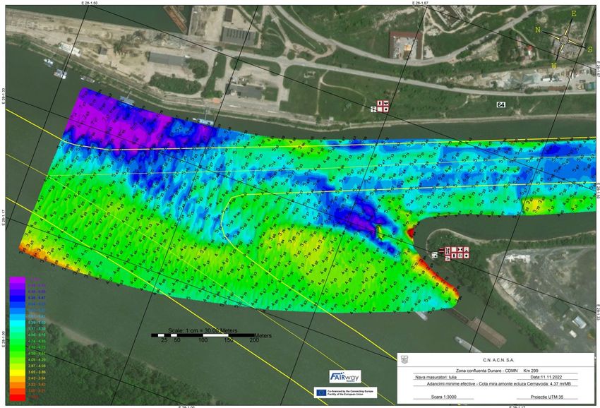
Administration of the Navigable Canals
Danube - Black Sea Canal is part of the Pan European Corridor VII and TEN-T and represents the
shortest way to reach the port of Constanta from the Danube (400 km shortening).The canal
assure a future beneficial link between NorthSea and Black Sea.The Administration of the
Navigable Canals (ACN) was founded in 1984 under the authority of the Ministry of Transportation.
In 1998 became national company.
1.THE MAIN DANUBE BLACK SEA CANAL 2.NORTHEN BRANCH POARTA ALBA MIDIA
GENERAL TECHNICAL CHARACTERISTICS GENERAL TECHNICAL CHARACTERISTICS
Length 64,4 Length 27,5 km
Breadth of the 90 m Breadth of the 45 m
waterway waterway
Canal water depth 7,0 m Canal water depth 5,5 m
Maximum draft 5,5 m Maximum draft 3,8 m
Bridge clearance 16,5 m Bridge clearance 12,5 m
LOCKS OF THE CANAL
LOCKS OF THE CANAL
Cernavoda km 60+300
Ovidiu km 11+500
Agigea Km 1+900
Navodari Km 1+500
PORTS ON THE CANAL
PORTS ON THE CANAL
Medgidia km 37+500 right
bank Luminita Lake Tasaul
Basarabi km 25 Ovidiu km 11 right bank
Characteristic Pushed convoy Self propelled vessels Characteristic Pushed convoy
Capacity 6 x 3000 tc 5000 tdw Capacity 3000 tc
Length 296 m 138,3 m Length 120 m
Width 23 m 16,8 m Width 11,5 m
Draft 3,8 m 5,5 m Draft 3,8 m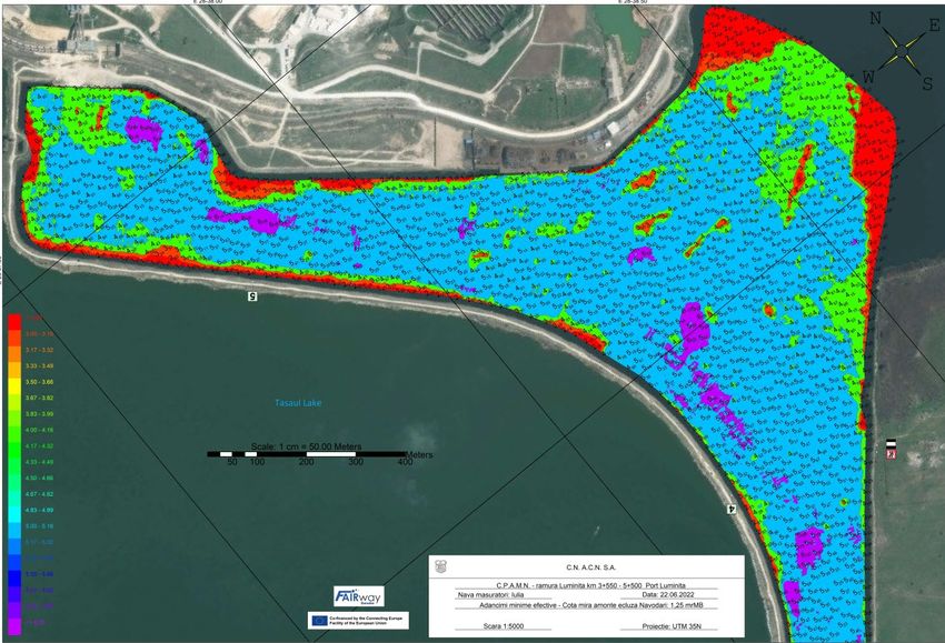
The time for locking process before and after
        rehabilitation of Agigea lock, Cernavoda lock,
                          Ovidiu Lock
             AGIGEA                           CERNAVODA                       OVIDIU
   BEFORE             AFTER            BEFORE             AFTER         BEFORE         AFTER
    (2012)            (2023)            (2012)            (2023)         (2012)        (2023)
62 min + 20 sec   53 min + 11 sec   55 min + 30 sec   39 min + 46 sec   39 min         29 min

        The rehabilitation ensure the navigation safety
                     and the traffic flow.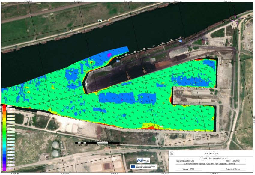
THE MAIN DEPARTMENTS THAT ENSURE THE SAFETY OF
                NAVIGATION ON DBSC AND PAMNC
Department of Naval Traffic                          Department of management of lock and
      Management                                                pump stations
                                                             Organizes, coordinates, guides and controls the
     Prepare, follow and observe the daily transit            operation and maintenance activity in order to
         program of ships on the waterways                   ensure the proper functioning of the equipment
                                                            and installations in the endowment of the lock and
                                                                               pump stations

    The RoRIS centers will keep in touch with the
    vessels in the VHF channels and continuously             Ensuring the normal water level for the operation
     monitor their journey on the electronic map            of the navigable channels, the optimal operation of
                                                             the pumping stations and the maintenance of the
                                                                        equipment and installations

      Receives, records and checks the RoRIS
    database for the transitation on the waterways           Organizes, coordinates, guides and controls the
                                                             activity of Cernavodã Complex Pumping Station
                                                            and pumping stations defending localities against
                                                                 floods (Saligny Faclia and Mircea Voda)
   Analyze the hydrographic measurements received
    and take all necessary measures to conduct the
                 navigation in full safety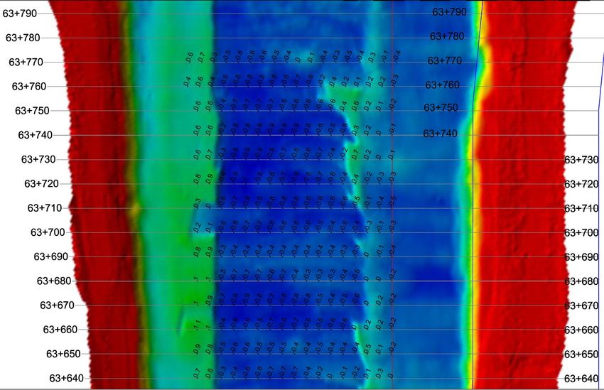
Telecommunications and signaling                         Hydro-Topo measurement
        Compartment                                           Compartment
                                                           It carries out the company’s policy regarding the
      Ensures the operation and maintenance of the
                                                               monitoring of the construction behavior in
      telecommunications equipment and navigation
                                                          operation through topogeodetic, hydrographic and
                 signals of the company
                                                                          A.M.C measurements

         Participates directly in the operations of            Perform topographic measurements for
     commissioning equipment and installations as well    establishing horizontal and vertical movements of
        as in the execution of maintenance works                     hydrotechnical constructions

           Organize the measurement activities for
     telecommunications equipment, signals and works       Performs hydrographic measurements, process
      to restore communications in case of damage or              and interprets the obtained data
                        disturbances

                                                          Materialise the data in situation plans, profiles and
                                                          level curves, representing the depths of the water
                                                            canvas and determines the actual quantities of
                                                                        material to be dredged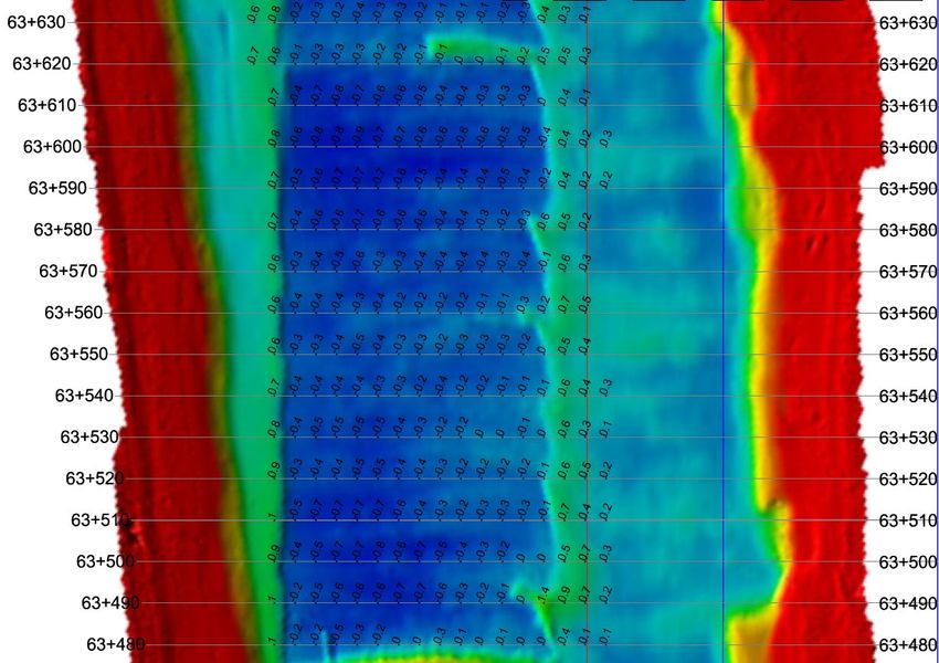
Monitoring and Actions between 2020-2022
On Danube Black Sea Canal and Northen Branch Poarta Alba Midia between 2020 and 2022 there was good
hydrological conditions with water level.
The most important sector of the navigable canals is the sector between Danube and Cernavoda locks, due
to variation of the water level according with Danube .
In order to determine the opportunity to start dredging works, an acceptable limit of average deposits and a
threshold of the level of deposits at which it is necessary to start dredging works have been established.
These limits have been established by calculation, considering various levels of average deposits on a
certain percentage of the width of the bottom section of the canal, and the flow velocity should not exceed
the imposed maximum limit of 0.5 m/s, according to Operational and Maintenance Regulation of the
Danube-Black Sea Canal.
According with the Operational and Maintenance Regulation deposits up to 1 m cannot be dredged due to
constructive solution of canal. For the 1st section it was established that the limit for starting of dredging
works is when the level of the deposits reaches a thickness of 2 m on a section width of 40% of the total
width.
For the other critical sections on navigable canals, the variation of the water level remained risk-free.
Every year we make inspection tours on the entire canals (DBSC and PAMNC) especially the critical sections,
wich we keep observing.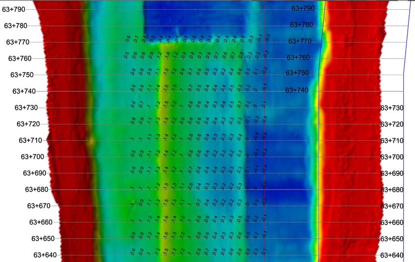
Since 2020, twice a year ACN perform inspections on the fairway(2x per year).
First inspection is for the limit of the fairway and the second one is for fairway axis . The monitoring is performed
with a vessel destined for shallow water with portable single-beam equipment, purchased within the FAIRway
Danube project.
Also the vessel destined for shallow water with portable single-beam equipment is used for the critical sections
where ACN is monitoring the depths according to the monthly measurements program.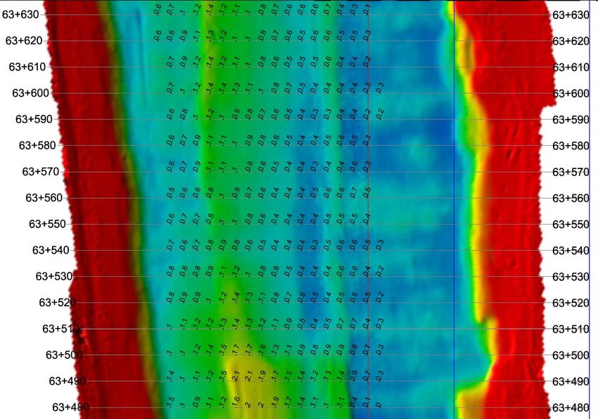
To inform everyone about ACN canals status regarding information about safety navigation, we
use platform "Notice to Skippers“.
"Notice to Skippers" are nautical publications containing information about safety navigation on
waterways. These publications serve to communicate details such as the status of waterway
infrastructure (locks, bridges), restrictions, temporary blockages of waterway sections or other
types of works, events taking place on the waterway, water level information, critical depths, ice
information and weather messages.
In the period 2020-2022 there were no restrictions for navigation in the reported critical
locations due to low navigable water levels.
Nevertheless, navigation on navigable canals was restricted or closed due to meteorological
conditions as follows:
2020 2021 2022
1. Due to unfavourable weather conditions
Measures taken by Romanian Naval Authority were to close the port of Constanta (for DBSC) and port of Midia (for PAMNC) and the measures
by ACN were to restrict navigation on the canals.
DBSC & PAMNC DBSC & PAMNC DBSC & PAMNC
WIND FOG WIND FOG WIND FOG
543h 155h 587h 112h 636h 60h
Total 698h Total 699h Total 695h
Water levels in period 2020-2023
 As reference we give August as an example due to the decreased water level
during this period to highlight that we have the depths necessary for navigation
                                      safety.

                          CERNAVODA                    AGIGEA                   OVIDIU                   NAVODARI

     DATA        UPSTREAM        DOWNSTREAM   UPSTREAM    DOWNSTREAM   UPSTREAM    DOWNSTREAM   UPSTREAM     DOWNSTREAM

   10.08.2020      4,86               7,21      7,22            7,80     7,27            1,55     1,53              6,08

   11.08.2020      4,80               7,13      7,14            7,80     7,20            1,54     1,52              6,11

   10.08.2021      4,89               7,15      7,13            7,58     7,13            1,86     1,65              6,13

   11.08.2021      4,80               7,17      7,13            7,54     7,17            2,05     1,65              6,07

   10.08.2022      2,64               7,22      7,31            7,53     7,33            1,59     1,56              6,13

   11.08.2022      2,68               7,28      7,35            7,54     7,37            1,56     1,56              6,12

   10.02.2023      8,02               7,30      7,31            7,63     7,36            1,69     1,70              6,06

   11.02.2023      7,91               7,55      7,56            7,52     7,58            1,67     1,68              6,17
CRITICAL SECTORS ON DBSC AND PAMNC IN 2020-2022
Cernavoda confluence
Medgidia port Km 37
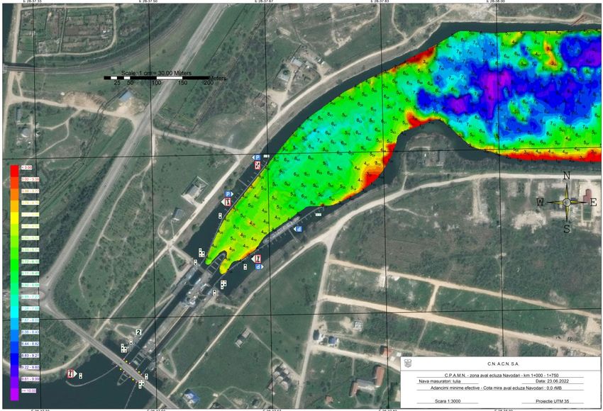
with Danube Km 64 - 65CRITICAL SECTORS ON DBSC AND PAMNC IN 2020-2022 Downstream Navodari Lock Km 1 - 2 Luminiţa port Km 4 - 5
SOME EXAMPLES FOR DREDGING
  WORKS THAT TOOK PLACE
    BETWEEN 2020-2022
DREDGING DBSC INTERVAL 2020-2022 AUGUST 2020 INITIAL AUGUST 2020 FINAL KM 63+480 – 63+630 KM 63+480 – 63+630
AUGUST 2020 INITIAL   AUGUST 2020 FINAL
 KM 63+640 - 63+790   KM 63+640 - 63+790
DREDGING DBSC FEBRUARY 2021
INITIAL KM 62+100 – KM 62+250          FINAL KM 62+100 – KM 62+250
DREDGING DBSC FEBRUARY 2021

INITIAL KM 61+940 – KM 62+090         FINAL KM 61+940 – KM 62+090
SECTION 1 – BYPASS CANAL JUNE 2021

INITIAL                         FINAL
MEDGIDIA JULY 2021 BASIN AND ENTRANCE HARBOUR PORT BEFORE AND AFTER
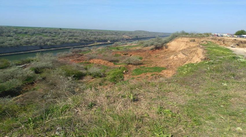
CUMPANA 2022
On the left bank of the Danube-Black Sea Canal between km 56+989 (km 7+421 navigation)
and km 57+217 (km 7+193 navigation), in Cumpana area took place a landslide. The landslide
affected both the quay area and a surface in the canal crown by slipping a quantity of
material that caused a navigation obstacle to appear.
Due to the continuous landslides, the waterway was obstructed.
According to bathymetric measurements resulted a volume of about 10,000 cubic meters wich
was dredged in 2022.
Initial bathymetric
                             measurement to
                             estimate the required
                             dredging volume.

Pre-dredging bathymetric
measurement for the
calculation area delimited
around dredging works.

                                  Final bathymetric
                                  measurement
Modernization of the Retehnologization of
mooring places of the Navodari locks in order to
Basarabi and Medgidia increase the safety of
ports navigation- technical
design and works
Modernization of the
navigable canals of the
Danube: Danube – Black
Sea channel and Poarta Monthly bathymetric
Alba – Midia, Navodari measurements for draft
channel in order to PLANNED needs
increase the safety of
navigation- technical MEASURES/
design and works PROJECTS TO
ENSURE
NAVIGATION
IN 2023.MODERNIZATION OF THE NAVIGABLE CANALS OF THE DANUBE: DANUBE – BLACK
SEA CHANNEL AND POARTA ALBA – MIDIA, NAVODARI CHANNEL IN ORDER TO
INCREASE THE SAFETY OF NAVIGATION
Danube Black Sea Canal Poarta Alba Midia Navodari Canal
Rehabilitation and completion of drainage, collection, routing and Rehabilitation and completion of drainage, collection, routing and
controlled discharge of exfiltration and rainwater into the canal controlled discharge of exfiltration and rainwater into the canal
Rehabilitation of technological roads for intervention Rehabilitation of technological roads for intervention
Rehabilitation of bridges over affluent valleys on technological roads Rehabilitation of bridges over affluent valleys on technological roads
Completion of slope protection Completion of slope protection
Rehabilitation of slopes affected by gullies Rehabilitation of slopes affected by gullies
Carrying out consolidation and slope support works on unstable areas protection of the limestone slope with anchored nets
Design and construction new route for optic fiber in order to ensure a Carrying out consolidation and slope support works on unstable areas
good communication between RORIS locations Design and construction new route for optic fiber in order to ensure a
good communication between RORIS locations
Also, in the feasibility study completed in 2022, evaluated the situation of alluvial materials deposits on the two navigable canals.The identified
obstacles(sand, rocks) will be included in the maintenance dredging activity to get the section of the fairway to the designed parameters.
The feasibility study covered the Danube Black Sea Canal, section between the confluence with the Danube and upstream of the Agigea locks, and
the Poarta Alba Midia Navodari Canal covered the section between the confluence with the Danube Black Sea Canal and upstream of the Navodari
locks.MODERNIZATION OF THE MOORING PLACES OF
BASARABI AND MEDGIDIA PORTS
• Mooring of convoys in safety condition in Basarabi and Medgidia
area
OBJECTIVE • Mooring in safety condition when navigation is closed due the bad
weather
• Rehabilitation of damaged Duc d’Albi constructions as well as
walkways between Duc d’Albi and access walkways to the quay
WORKS • Providing night lighting of the mooring place, the production of the
necessary electricity will be made from renewable sources
• Security measures of the mooring placeREHABILITATION OF NAVODARI LOCKS IN ORDER TO INCREASE NAVIGATION SAFETY –
technical design and works
MAIN OBJECTIVE- modernization of equipment and systems of Navodari locks to guarantee a good connection between
Danube River and Midia Port.
The project aims are modernization and rehabilitation of:
1.The basic technological equipments of the locks: 2.Auxiliary installations and equipments of the locks:
Plane Service Gates Dewatering installations
Locks’ drying system Pumping stations for emptying the lock
Plane valves Electric power supply installation
Activation hydraulic installation Diesel group -new generator
Control, action and automation electric installation Compressed air frost preventing installations
Protection installation of the service mitered-type gate Lock interior/exterior lighting installation
against ship striking
Lock control and supervision installation
Tilting mobile bridge
Equipments and installations related to the locks and navigation safety:
Prevention and fire fighting installations;
TV installations with closed circuit;
Telecommunication installations in the locks;
Installation of ship signaling near the lock gates;
Interconnection between signaling and lighting system for the locks navigation and lock control and supervision installation;
Niche protection panels
Fixed bollards 15KN;
Constructions protection for guiding the access inside the lock’s chamberMONTHLY MEASUREMENTS FOR DREDGING NEED
Operating costs of activities carried out in
                                2022
                  Budget requirements for 2023
                                             Operational
                                                            Required       Secured       Remaining
                                            expenditures
Need areas                                                 operational   operational   financing gap
                                               Jan-Dec
                                                           budget 2023   budget 2022       2023
                                                2022
                                              183.442 €
Minimum fairway parameters (width/depth)                        -                            -

Surveying of the riverbed                     24.894 €       25.494 €      25.494 €          -

Water level gauges                                -              -             -             -

Marking of the fairway                         1.910 €        6.565€        6.565€           -

Availability of locks / lock chambers       5,426,882 €    5.709.986 €   5.709.986 €         -

Information on water levels and forecasts         -              -             -             -

Information on fairway depths                     -              -             -             -

Information on marking plans                      -              -             -             -

Meteorological information                        -              -             -             -

Other needs                                  155.076 €      190.408 €     190.408 €          -

Total                                       5.792.204 €    5.932.453 €   5.932.453 €         -
I THANK YOU FOR YOUR ATTENTION TODAY
You can also read