Cobb County Secures World Series in Real Time - Esri
←
→
Page content transcription
If your browser does not render page correctly, please read the page content below
Cobb County Secures
World Series in Real Time
By Carl Walter
By the time the World Series came to Cobb County, Georgia, in fall 2021, the been tried and tested during big events.
technology and expertise demonstrated by the county staff orchestrating This includes the home games of profes-
public safety couldn’t help but win the attention of Major League Baseball’s sional baseball’s National League Division
Series, the National League Championship
technical team.
Series, the World Series, and security for the
National Football League’s 2019 Super Bowl
“They could walk into any conference room Smith’s 97-miles-per-hour, four-seam fast- game in Atlanta. This time the huge celebra-
and with just a click, they could see dash- ball was grounded out to end game six and tion would include a parade that would wind
boards with maps showing the location of the series on November 2, officials in Cobb through downtown Atlanta and culminate at
security staff, live traffic, and 911 calls,” said County, had only 35 hours to organize a the Braves’ home ballpark, Truist Park.
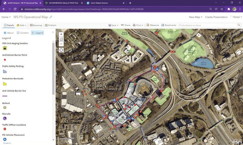
Jennifer Lana, GIS manager at Cobb County party for 350,000 guests. Jeremy “J.D.” Lorens, a lieutenant in
Government. “They hadn’t seen dynamic charge of traffic management at the Cobb
data that was so accessible before.” Instantly Planning a Party County Police Department, was assigned
Yet, as the Atlanta Braves took control It had been a while since the Atlanta Braves to handle parade security using up-to-
of the seven-game series the week of had a world championship to celebrate. The date maps and remote control of traffic
November 1, 2021, and county officials last time was in 1995 when the team was in lights. For home games at the ballpark,
wanted to plan for a massive victory cel- a different stadium and a different jurisdic- Lorens had already worked with a team of
ebration, preparations had to be delayed. tion. Even though there were no set plans GIS specialists to apply mapping for crowd
There’s a long-standing superstition in or knowledge about how to accommodate control, security, and traffic management.
baseball that planning a celebration before championship crowds, Cobb County’s in- Lorens would need the same detailed
the World Series concludes invites bad vestment in sophisticated mapping and maps—outside the stadium—to create
luck. So once Braves relief pitcher Will monitoring technology and staff have the parade route.
66 au Spring 2022 esri.com/arcuser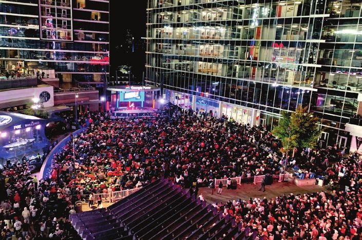
End Notes
The GIS team provided tools to help Advanced Stadium Technology officers synchronize the flow of vehicle and
the Braves organization as well as state Before Truist Park opened in 2017, Cobb pedestrian traffic during regular games.
and county officials define and approve County authorities invested in advanced Cobb County’s Public Safety depart-
the route. Lorens gathered barricades that traffic management technology to move ments regularly use GIS dashboards and
matched the narrow three-lane corridor fans quickly and easily to and from the data to ensure public safety. These sea-
he had mapped to reduce roadway width ballpark. Truist Park is located near the in- soned GIS users trust and know how to use
and put the crowd in proximity to players. tersection of two interstate highways, and the data, maps, and dashboards and have
“I knew there would be families with little authorities wanted to ensure that the sta- seen how location intelligence helps them.
kids,” he explained. “I wanted to get them dium location lessened rather than added These trained users then became the train-
as close to the parade as possible.” to Atlanta’s traffic congestion. ers as more personnel were added during
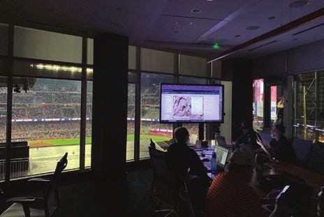
During the parade, GIS maps displayed Lorens oversees traffic management at the playoff run.
the location of every officer along the the ballpark and runs the control center with For the 2021 World Series games, the
route, allowing incident commanders to live feeds of 70 cameras monitoring path- number of police officers for a typical game
see the location of each asset in case of an ways and The Battery Atlanta, an entertain- was doubled to handle the larger crowds
emergency. The smooth operation of the ment district. There are 30 more cameras and longer hours. Officers were organized
parade allowed Lorens to craft an efficient at critical intersections. GIS allows Lorens into three main groups: inside the stadium,
plan for removing the barricades begin- and the team to visualize the location and traffic and operations, and overall campus
ning when the procession was halfway condition of every traffic light and camera. security. The groups relied on GIS for real-
through its route. Using these inputs and controls, he and his time information and communication.
Cobb County had to quickly plan a giant celebration after the Atlanta Braves World Series victory including a parade that would wind
through downtown Atlanta and culminate at the Braves’ home ballpark, Truist Park.
For the World Series games and the victory celebration, Cobb County Police Department had to ensure the safety of massive crowds.
esri.com/arcuser Spring 2022 au 67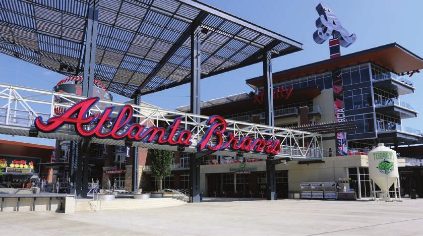
“We normally see 40,000 people in at 11:00 a.m. for a 7:00 p.m. game.” changes in traffic-light sequences to keep
the stadium and another 5,000 people in Location is also critical for the county’s people and vehicles flowing.
The Battery,” Lorens said. “For the World artificial intelligence (AI) system used to “We have 50 different datasets on the
Series games, we had 100,000 people on a analyze foot traffic from the video feeds. map from the footprint of the stadium, all
100-acre footprint, and we saw traffic start GIS and AI technologies combine to inform the businesses, the lights and cameras,
the traffic data feed, 911 calls, traffic from
Uber and Lyft rideshares, and the location
of Cobb County vehicles,” Lana said. “We
have built that awareness over time, so we
didn’t have to change much for the World
Series, but there were modifications.”
Lorens has learned that each game has
a distinct traffic pattern, and he developed
specific maps for day versus night games or
weekday versus weekend games. When it
came to the playoffs though, he could not
count on prior predictability.
“Once you get to a championship series,
it doesn’t matter what day the game falls
on, because everyone takes off work,”
Before Truist Park opened in 2017, Cobb
County authorities invested in advanced
traffic management technology to monitor
and move fans quickly and easily to and
from the ballpark and maintain public safety.
68 au Spring 2022 esri.com/arcuser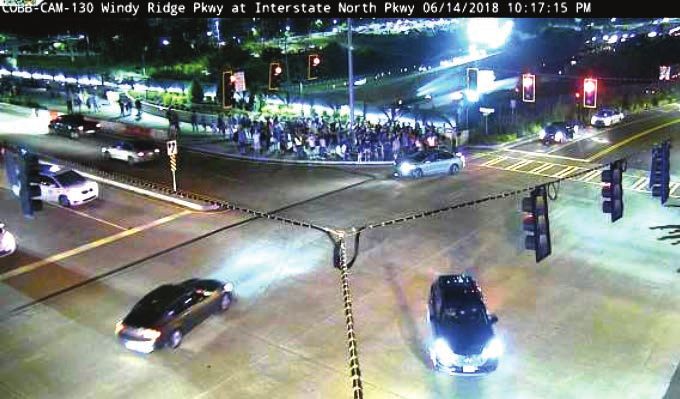
End Notes
Cobb County relied on ArcGIS Mission
to track the location of roving plainclothes
officers working throughout the area
surrounding Truist Park. This enabled
the operations center to make tactical
resource assignments and get real-
time updates from the field, then share
information across teams.
Managing the parade route required
rapid and careful planning.
Lorens said. “You go to the most robust
map you have, and you use that.”
Dashboards and Real-Time
Tracking
Having a well-provisioned stadium security
setup has helped Cobb County deal with
the unanticipated nature of professional
baseball planning. As the team worked its
way through the playoffs, each subsequent field, then share information across teams. dangerous situation was happening, and
win and series ratcheted up interest and at- The fact that the app could be accessed in the command center we knew no officer
tendance at the games. on a smartphone was key to the stealth re- could get lost in the crowds.”
The primary GIS toolset Cobb County quirements of the operation. Other smartphone features also came in
relied on included ArcGIS Mission, which “Undercover officers are in a unique handy.
tracked the location of roving plainclothes situation because they don’t have radios,” “Our analysts,” Lorens said, “could look
officers working throughout The Battery. Lana said. “But everyone on the planet up a license plate tag or provide back-
With command and control software, the has a smartphone, and nobody is going ground information. When it’s just a text,
incident commanders in the operations to think twice about someone looking that can get siloed between two people,
center could make tactical resource assign- at a map on their phone. On the app, of- and here everybody was able to see it and
ments and get real-time updates from the ficers could see each other and where a add to it if needed.”
esri.com/arcuser Spring 2022 au 69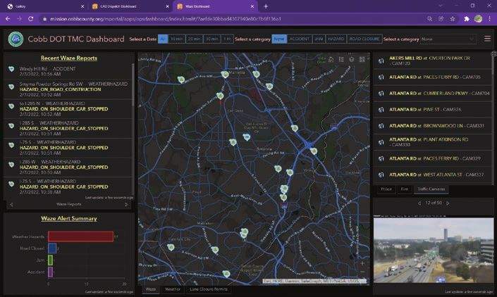
Esri
Resources
Esri Technical Support
esri.com/support
Esri Desktop Order Center and
Software Information
t 800 447 9778 (usa only)
Esri Products
esri.com/products
Esri Store
With feeds from 30 cameras at critical intersections, the public safety team used GIS esri.com/store
to visualize conditions at every traffic light location. ArcGIS Developer
developers.arcgis.com
Putting the Wraps on a Stellar baseball custom against preplanning for Customer Care Portal
my.esri.com
Season victory, they won’t put plans in motion too
For Cobb County’s World Series games, far ahead. Esri US Regional Offices
the use of ArcGIS Mission was tactical, esri.com/about-esri/usa
guiding public safety response to inci- About the Author Esri Distributors
dents involving unruly behavior. “There Carl Walter, Esri’s director of corporate esri.com/distributors
were a lot of drunk people everywhere,” security solutions, is responsible for direct-
Lana said. “Each time the Braves won, the ing Esri’s outreach strategies as they relate
crowds got bigger and crazier.” to the use of analytical solutions within
For Lorens and his public safety team, a the homeland and national security mar-
kets globally. He joined Esri in 2010, after Copyright © 2022 Esri.
map was key to keeping control of rowdy
All rights reserved.
situations. “We were able to see where 20 years of increasing responsibility in law Printed in the United States of America.
our people are and put them in places enforcement and intelligence operations.
so everybody else saw them,” he said. Shortly after the September 11 attacks in The information contained in this document is the exclusive
“For commanders, we could make sure 2001, Walter was appointed director of the property of Esri or its licensors. This work is protected
under United States copyright law and other international
we had coverage so that nothing critical Boston Regional Intelligence Center, a US copyright treaties and conventions. No part of this work
happened.” Department of Homeland Security desig- may be reproduced or transmitted in any form or by any
means, electronic or mechanical, including photocopying
Lorens and his team applied GIS in nated intelligence fusion center. He em- and recording, or by any information storage or retrieval
a more integrated way for the victory braced the new paradigm of intelligence system, except as expressly permitted in writing by Esri. All
requests should be sent to Attention: Director, Contracts
parade. To ensure safety and ease traffic sharing and established a decentralized and Legal Department, Esri, 380 New York Street,
disruptions, the ability to track officers security node in the Boston metropolitan Redlands, CA 92373-8100 USA.
and floats in real time was critical. This area of responsibility, tasked with meeting The information contained in this document is subject to
is an operational methodology that the regional intelligence needs while providing change without notice.
county will employ moving forward. “Now real-time information to help understand Esri products or services referenced in this publication are
we’ve got a blueprint,” Lana said. the national landscape of terrorist threats trademarks, service marks, or registered marks of Esri in
the United States, the European Community, or certain
Lorens added, “I plan to build out the and criminal activity. On special assignment, other jurisdictions. To learn more about Esri marks go to:
map of where we had bottlenecks and Walter served as the planning section chief
w w w.esri.com/content/dam/esrisites/en-us/media/legal
where we responded with more staff, and for the Democratic National Convention in /copyrights-and-trademarks/esri-product-naming-guide.pdf.
I’ll keep that in my back pocket.” Boston in 2004. He also served as the direc-
Other companies and products or services mentioned
With the Braves’ core of young stand- tor, Bureau of Intelligence and Analysis, for herein may be trademarks, service marks, or registered
out players, fans in and around Atlanta the Boston Police Department. He holds a marks of their respective mark owners.
hope there will be cause for another master’s degree in criminal justice from the
World Series and parade, another op- University of North Carolina at Charlotte,
portunity for Cobb County officials to and a bachelor’s degree in criminal justice
demonstrate their championship crowd from East Carolina University in Greenville,
expertise. But considering the age-old North Carolina.
70 au Spring 2022 esri.com/arcuser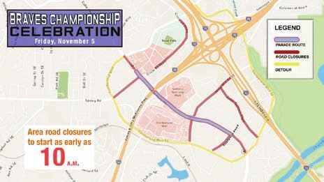
You can also read