CHAPTER X. PRIORITY HABITAT ISSUES: SUBMERGED AQUATIC VEGETATION HABITAT PROTECTION AND RESTORATION WITH FOCUS ON WATER QUALITY - NC.gov
←
→
Page content transcription
If your browser does not render page correctly, please read the page content below
CHAPTER X. PRIORITY HABITAT ISSUES: SUBMERGED AQUATIC VEGETATION HABITAT
     PROTECTION AND RESTORATION WITH FOCUS ON WATER QUALITY

1.1. Issue
Protection and restoration of submerged aquatic vegetation (SAV) is critical for healthy fisheries in NC
while also providing additional valuable ecosystem functions and benefits that enhance coastal
resiliency of aquatic life and coastal communities. Nationally, water quality and particularly water clarity
is recognized as one of the most significant factors limiting SAV distribution, abundance, survival, and
expansion. Regionally, on the Atlantic seaboard of the U.S., large declines of SAV have been attributed
to impaired water quality in neighboring estuaries both north (Chesapeake Bay) and south (Indian River
Lagoon, FL) of NC. Environmental monitoring data indicate that water quality is also having an adverse
impact on SAV in NC estuarine waters, especially in the relatively lower salinity regions more directly
impacted by numerous watersheds and coastal land use. Water quality impairment coupled with the
expectation of rising sea level and increasing water temperatures associated with climate change, will
expose all SAV in NC to multiple stressors that can limit their growth, reproduction, and distribution.
1.2. Origination
Division of Marine Fisheries (DMF), Albemarle-Pamlico National Estuary Partnership (APNEP), and the
Coastal Habitat Protection Plan (CHPP) Steering Committee
1.3. Background
Currently, NC is steward to one of the most productive and biodiverse SAV resources on the Atlantic
seaboard, including the largest polyhaline and mesohaline seagrass meadows in the temperate western
Atlantic. 1 SAV habitat is the foundation for ecological services that directly benefit the coastal
ecosystems of NC and neighboring states. 2 These services include primary and secondary fisheries
production, habitat for fish, wildlife and waterfowl, sediment and shoreline stabilization, wave energy
attenuation, water purification, and carbon sequestration. Recently, it has been shown that SAV may
reduce bacterial pathogens that can cause disease in humans and marine organisms. 3 All these services
are important to a healthy ecosystem and provide increased community and ecosystem resilience. 4
Resource valuation studies indicate that the monetary value of the ecosystem services provided makes
SAV habitat protection and restoration a priority conservation and management issue. SAV contributes

1 Thayer, G. W., W. J. Kenworthy, and M. S. Fonseca. 1984. The ecology of eelgrass meadows of the Atlantic coast: a community profile. U.S.
Fish and Wildlife Service;
Carraway, R.J. and L.J. Priddy. 1983. Mapping of submerged grass beds in Core and Bogue Sounds, Carteret County, North Carolina, by
conventional aerial photography. North Carolina Department of Natural Resources and Community Development. Office of Coastal
Management. Morehead City, NC;
Ferguson, R. L. and L. L. Wood, 1990. Mapping Submerged Aquatic Vegetation in North Carolina with Conventional Aerial Photography, Federal
Coastal Wetland Mapping Programs (S. J. Kiraly, F. A. Cross, and f, D. Buffington, editors), U.S. Fish and Wildlife Service Biological Report
90(18):725-733;
Ferguson, R. L. and L. L. Wood, 1994. Rooted vascular beds in the Albemarle-Pamlico estuarine system. Albemarle-Pamlico Estuarine Study,
Project No. 94-02, N.C. Department of Environmental Health and Natural Resources, Raleigh, N. C., and U. S. EPA, National Estuary Program;
Green, E. P., F.T. Short, and T. Frederick. 2003.World atlas of seagrasses. University of California Press;
NCDEQ (North Carolina Department of Environmental Quality). 2016. North Carolina Habitat Protection Plan. Raleigh, NC
2 Orth, R. J., T. J. B. Carruthers, W. C. Dennison, C. M. Duarte, J. W. Fourqurean, K. L. Heck, A. R. Hughes, G. A. Kendrick, W. J. Kenworthy, S.

Olyarnik, F. T. Short, M. Waycott, and S. L. Williams. 2006. A global crisis for seagrass ecosystems. Bioscience 56(12):987-996;
Lefcheck, J.S, R.J. Orth, W.C. Dennison, D.J. Wilcox, R.R. Murphy, J. Keisman, C. Gurbisz, M. Hannam, J.B. Landry, K.A. Moore, C.J. Patrick, J.
Testa, D.E. Weller, and R.A. Batiuk. 2018. Long-term nutrient reductions lead to the unprecedented recovery of a temperate coastal region.
Proceedings of the National Academy of Sciences. 115. 201715798. 10.1073/pnas.1715798115;
3
  Lamb, J.B., J.A.J.M van de Water, D.G. Bourne, C. Altier, M.Y. Hein, E.A. Fiorenza, N. Abu, J. Jompa, and C.D. Harvell. 2017. Seagrass ecosystems
reduce exposure to bacterial pathogens of humans, fishes, and invertebrates. Science 355(6326):731-733
4 NCDEQ (North Carolina Department of Environmental Quality). 2020. North Carolina Climate Risk Assessment and Resiliency Plan. 1601 Mail

Service Center, Raleigh, NC

                                                                                                                                                 1
to coastal resilience and economic and cultural values from the local coastal community and residents
statewide, to the millions of annual visitors to NC. 5
Submerged aquatic vegetation is important to many aquatic organisms at some point in their life cycle,
with fish and invertebrates depending on SAV for refuge, spawning, nursery, foraging, and corridor
needs. Because of the seasonal abundance patterns of SAV, refuge and foraging habitat are provided
almost year round for estuarine-dependent species. Fish and invertebrate use of SAV differs spatially
and temporally due to distribution ranges, time of recruitment, and life histories. 6 Table x.1 provides a
list of species that use SAV in NC.

5
  Costanza, R., R. d'Arge, R. deGroot, S. Farber, M. Grasso, B. Hannon, K. Limburg, S. Naeem, R. V. Oneill, J. Paruelo, R. G. Raskin, P. Sutton, and
M. Vandenbelt. 1997. The value of the world's ecosystem services and natural capital. Nature 387(6630):253-260;
Barbier, E.B., S.D. Hacker, C. Kennedy, E.W. Koch, A.C. Stier, and B.R. Silliman. 2011 The value of estuarine and coastal ecosystem services.
Ecological Monographs 81:169–93;
APNEP (Albemarle-Pamlico National Estuary Partnership). 2012a. Comprehensive conservation and management plan. APNEP, 1601 Mail
Service Center, Raleigh, NC;
Cullen-Unsworth, L.C., L.M. Nordlund, J. Paddock, S. Baker, L.J. McKenzie, and R.K. Unsworth. 2013. Seagrass meadows globally as a coupled
social-ecological system: Implications for human wellbeing. Marine pollution bulletin. 83. 10.1016/j.marpolbul.2013.06.001;
M. Nordlund, L., E.W. Koch, E.B. Barbier, and J.C. Creed. 2016. Seagrass ecosystem services and their variability across genera and geographical
regions. PLoS One, 11(10), e0163091.;
Ibid, 4
6 Nelson, D. M., M. E. Monaco, E. A. Irlandi, L. R. Settle, and L. Coston-Clements. 1991. Distribution and abundance of fishes and invertebrates in

southeast estuaries. NOAA/NOS Strategic Environmental Assessment Division, Silver Spring, MD
Hovel, K. A., M.S. Fonseca, D.L. Myer, W.J. Kenworthy, and P.E. Whitfield. 2002. Effects of seagrass landscape structure, structural complexity
and hydrodynamic regime on macrofaunal densities in North Carolina seagrass beds. Marine Ecology Progress Series 243:11-24;
Heck, K. L., T. J. Carruthers, C. M. Duarte, A. R. Hughes, G. Kendrick, R. J. Orth, and S. W. Williams. 2008. Trophic transfers from seagrass
meadows subsidize diverse marine and terrestrial consumers. Ecosystems 11:1198-1210

                                                                                                                                                  2
Table X.1. List of fish and invertebrate species documented to use submerged aquatic vegetation (SAV)
habitat. Names in bold are species with relative abundances reported in literature as higher in SAV than
other habitats. Note: lack of bolding does not imply non-selective use of the habitat, but lack of
information. 7
                                                             Submerged Aquatic Vegetation (SAV) Functions 8
    Species                               Refuge              Spawning     Nursery          Foraging        Corridor
    River herring*                             X                                  X              X                X
    Striped bass                                                                                 X
    Yellow perch                                                   X
    American eel                                 X                                X              X                X
    Bay scallop                                  X                 X              X              X
    Blue crab                                    X                                X              X                X
    Grass shrimp                                 X                                X              X
    Hard clam                                    X                                X              X
    Red drum                                     X                                X              X                X
    Spotted seatrout                             X                 X              X              X                X
    Weakfish                                     X                                X              X                X
    Atlantic croaker                             X                                X              X                X
    Atlantic menhaden                            X                                X              X                X
    Brown shrimp                                 X                                X              X                X
    Southern flounder                                                             X              X
    Spot                                         X                                X              X                X
    Striped mullet                               X                                X              X                X
    White shrimp                                 X                                X              X                X
    Black sea bass                               X                                X              X                X
    Bluefish                                                                      X              X
    Gag                                          X                                X              X                X
    Kingfish spp.                                X                                X              X                X
    Pinfish                                      X                                X              X                X
    Pink shrimp                                  X                                X              X                X
    Smooth dogfish                                                                               X
    Spanish mackerel                                                              X              X
    Summer flounder                                                               X              X
*Includes blueback herring and alewife

The Fisheries Reform Act of 1997 requires the DMF to prepare fishery management plans (FMP) for
adoption by the NC Marine Fisheries Commission (MFC) for all commercially and recreationally
significant species or fisheries that comprise state marine and estuarine resources. The goal of the plans
is to ensure long-term viability of these fisheries. Fisheries habitat and water quality considerations are
one of several requirements of these plans and are to be consistent with the CHPP. Several state FMPs

7 Ibid, 4
8 ASMFC (Atlantic States Marine Fisheries Commission). 1997. Atlantic coastal submerged aquatic vegetation: a review of its ecological role,
anthropogenic impacts, state regulation, and value to Atlantic coastal fisheries;
Ibid, 1;
Peterson, C. H., and N. M. Peterson. 1979. The ecology of intertidal flats of North Carolina: A community profile. U.S. Fish and Wildlife Service;
NMFS (National Marine Fisheries Service). 2002. Annual Report to Congress on the Status of U.S. Fisheries - 2001. NOAA, Silver Spring, MD;
SAFMC (South Atlantic Fishery Management Council). 1998. Final Habitat Plan for the South Atlantic Region: Essential Fish Habitat
Requirements for Fishery Management Plans of the South Atlantic Fishery Management Council. South Atlantic Fishery Management Council,
Charleston, SC;
Odell, J., D. H. Adams, B. Boutin, W. Collier II, A. Deary, L. N. Havel, J. A. Johnson Jr., S. R. Midway, J. Murray, K. Smith, K. M. Wilke, and M. W.
Yuen. 2017. Atlantic Sciaenid Habitats: A Review of Utilization, Threats, and Recommendations for Conservation, Management, and Research.
Atlantic States Marine Fisheries Commission Habitat Management 14, Arlington, VA.

                                                                                                                                                    3
list SAV and water quality management actions because of the importance of SAV and water quality to
the different fisheries that are managed and prosecuted within the state. The Blue Crab Fishery
Management Plan Amendment 3 (2020) is the latest plan with management actions that focus on water
quality (NCDMF 2020). 9 One action specifically tasks the CHPP Steering Committee to prioritize blue crab
water quality impacts (Table X.2). The Blue Crab FMP is one of several FMPs that have both SAV and
water quality management actions that overlap with the CHPP issue of protection and restoration of
SAV through water quality improvements (Table X.2).
Table X.2. NC State Fishery Management Plans with SAV and water quality actions.
    NC Fishery
    Management Plan 10       Habitat and Water Quality Management Actions
    Bay Scallop             • Remap and monitor SAV coverage in NC to assess distribution and change over time
    Amendment 2             • Restore coastal wetlands to compensate for previous losses and enhance water
    (2015)                      quality conditions for the bay scallop
                            • Improve methods to reduce sediment and nutrient pollution from construction sites,
                                agriculture, and forestry
                            • Reduce impervious surfaces and increase on-site infiltration of stormwater through
                                voluntary or regulatory measures
                            • Aggressively reduce point and non-point nutrient and sediment loading in estuarine
                                waters, to levels that will sustain SAV habitat, using regulatory and non-regulatory
                                actions
    Blue Crab               • Create a joint interagency work group
    Amendment 3             • Task the CHPP steering committee to prioritize blue crab water quality impacts
    (2020)                  • Send letters to other state agencies sharing concerns about water quality and Best
                                Management Practices
                            • Invite other agencies to future MFC meetings to present their efforts to address water
                                quality
    Estuarine Striped       • Work with WRC, DWQ, and others to implement management measures that will
    Bass Amendment 1            enhance water quality in Strategic Habitat Areas (SHAs) used by striped bass
    (2013)                  • DMF and WRC should work with DWQ and other agencies to initiate efforts to
                                determine and establish more stringent water quality standards in waters designated
                                as Anadromous Fish Spawning Areas (AFSAs)
    Kingfishes (2007)       • Reduce nutrient and sediment loading in the Albemarle-Pamlico system, particularly
                                the Neuse and Tar-Pamlico rivers, to levels that will support SAV, using regulatory and
                                non-regulatory actions

9 NCDMF (North Carolina Division of Marine Fisheries). 2020. North Carolina Blue Crab Fishery Management Plan Amendment 3. Morehead
City, NC.
10 NCDMF (North Carolina Division of Marine Fisheries). 2015. North Carolina Bay Scallop Fishery Management Plan Amendment 2. Morehead

City, NC;
Ibid 9;
NCDMF (North Carolina Division of Marine Fisheries). 2013. North Carolina Estuarine Striped Bass Fishery Management Plan Amendment 1.
Morehead City, NC;
NCDMF (North Carolina Division of Marine Fisheries). 2020. North Carolina Kingfishes Fishery Management Plan. Morehead City, NC;
NCDMF (North Carolina Division of Marine Fisheries). 2015. North Carolina River Herring Fishery Management Plan Amendment 2. Morehead
City, NC;
NCDMF (North Carolina Division of Marine Fisheries). 2013. North Carolina Southern Flounder Fishery Management Plan Amendment 1.
Morehead City, NC;
NCDMF (North Carolina Division of Marine Fisheries). 2014. North Carolina Spotted Seatrout Fishery Management Plan Revision. Morehead
City, NC;
NCDMF (North Carolina Division of Marine Fisheries). 2020. North Carolina Striped Mullet Fishery Management Plan Amendment 1. Morehead
City, NC.

                                                                                                                                     4
NC Fishery
     Management Plan 10         Habitat and Water Quality Management Actions
                               • Improve methods to reduce sediment and nutrient pollution from construction sites,
                                   agriculture, and forestry
                               • Increase on-site infiltration of stormwater through voluntary or regulatory measures
                               • Modify stormwater rules to more effectively reduce the volume and pollutant loading
                                   of stormwater runoff entering coastal waters
     River Herring             • Work with other agencies to identify potential incentives for landowners for
     Amendment 2                   protection of riparian buffers in the management area
     (2015)                    • Develop, identify and clarify what critical habitat actions are needed to protect,
                                   enhance and restore habitats and water quality affecting river herring.
     Southern Flounder         • Coordinate SAV mapping efforts such that statewide monitoring and trend analysis
     Amendment 1                   can be conducted most efficiently
     (2013)                    • Reduce point and non-point nutrient and sediment loading in estuarine waters, to
                                   levels that will sustain SAV, using relevant standards and regulatory/non-regulatory
                                   actions
                               • Acquire updated and coast-wide data on bathymetry, sediment type, and pollutant
                                   concentrations
                               • Increase coverage of waters assessed for aquatic life and increase coverage of
                                   continuous monitoring stations
                               • Restore hydrology on lands used for silvaculture, agriculture, and urban development
                                   using Best Management Practices
     Spotted Seatrout          • Continue mapping of SAV in NC to assess distribution and change over time
     Revision (2014)           • Aggressively reduce point and non-point nutrient and sediment loading in estuarine
                                   waters, to levels that will sustain SAV, using regulatory and non-regulatory actions
                               • Work with NOAA and DWQ to determine appropriate levels of total suspended solids
                                   (TSS), turbidity, chlorophyll a, and other water clarity parameters to achieve adequate
                                   water quality conditions for SAV growth, and model potential SAV habitat
                               • Improve methods to reduce sediment and nutrient pollution from construction sites,
                                   agriculture, and forestry
                               • Increase on-site infiltration of stormwater through voluntary or regulatory measures
                               • Work with DWQ and EMC to modify stormwater rules to more effectively reduce
                                   runoff volume and pollutant loading to coastal waters to levels that protect and
                                   enhance fish habitats vital to spotted seatrout
                               • Reduce impervious surfaces associated with new development as much as possible
                                   and reduce the maximum amount of impervious surfaces allowed in the absence of
                                   engineered stormwater controls
     Striped Mullet            • Develop and maintain accurate maps and documentation of wetlands, soft bottom,
     Amendment 1                   SAVs, and water column
     (2015)                    • Support research on the causes of hypoxia and anoxia and impacts on striped mullet
                                   populations in North Carolina’s estuarine waters

There are two distinct groups of SAV ecosystems in NC distributed according to the estuarine salinity.
One group thrives in fresh and low salinity riverine waters (10 ppt) salinity estuarine waters of the bays, sounds, and
tidal creeks, referred to as high salinity SAV or seagrasses. Collectively they are referred to as SAV. These
groups are distinguished by different species composition and living requirements, and have
characteristics similar to SAV communities found in many other estuaries in the U.S. (Table X.3). 11

11   Stevenson, J. C. 1988. Comparative Ecology of Submersed Grass Beds in Freshwater, Estuarine and Marine Environments. Limnology and

                                                                                                                                          5
Table X.3. Average environmental conditions at locations where submerged aquatic vegetation (SAV)
occurred in coastal North Carolina, 1988-1991.12
                                                                          Environmental parameter
                                                                 Salinity      Secchi depth     Water depth
                                                                  (ppt)           m (ft)          m (ft)
SAV species                                                  Range Average Range Average Range Average
HIGH SALINITY (
Because SAV are rooted in anaerobic sediments, they need to produce a large amount of oxygen to
aerate the roots, and therefore have the highest light requirements of all aquatic plants. 17 SAV can
become stressed by eutrophication and other environmental conditions which impair water
transparency and/or diminish the oxygen content of water and sediments. The plant’s response to these
factors makes them a sensitive bio-indicator of environmental health. 18 Required light conditions can
vary by species; low salinity grass species have slightly lower light requirements of >9% of surface
incident light required at the leaf and >13% of surface incident light required through the surface
compared to >15% and >22%, respectively, for species found in moderate to high salinity areas. 19
High salinity SAV in coastal NC occurs on shallow back-barrier bars behind the Outer Banks (Pamlico,
Core, Back, and Bogue sounds), and along the mainland shores. 20 Estuarine high salinity SAV occurs at a
smaller scale in protected coastal embayments, marsh channels and along the Intracoastal Waterway,
south of Bogue Inlet to around Mason’s Inlet in northern New Hanover County. It has been documented
in the New River, Chadwick Bay, Topsail Sound, and along the edges of creeks and the Intracoastal
Waterway. In the fresh and brackish water portions of NC estuaries, low salinity SAV is abundant in
larger black water systems, but rare in small black water streams, due to tannic water, irregular flows
and shading from forested wetlands. SAV can be extensive in low-salinity back bays and lagoons, such as
Albemarle and Currituck sounds, tributaries of the Pamlico and Neuse rivers, and in coastal lakes like
Lake Mattamuskeet (not included in SAV coverage estimates). 21

69:1775-1786;
Kenworthy, W. J. and D. E. Haunert. 1991. The light requirements of seagrasses: proceedings of a workshop to examine the capability of water
quality criteria, standards and monitoring progress to protect seagrasses. National Oceanic and Atmospheric Administration, Beaufort, NC;
Ibid, 16;
Gallegos, C. L. 1994. Refining habitat requirements of submerged aquatic vegetation: role of optical models. Estuaries 17(18):187-199
Moore, K. A., H. A. Neckles, and R. J. Orth. 1996. Zostera marina (eelgrass) growth and survival along a gradient of nutrients and turbidity in the
lower Chesapeake Bay. Marine Ecology Progress Series 142(.):247-259.
Moore, K. A., R. L. Wetzel, and R. J. Orth. 1997. Seasonal pulses of turbidity and their relations to eelgrass (Zostera marina L.) survival in an
estuary. Journal of Experimental Marine Biology and Ecology 215(.):115-134;
Koch, E. W. 2001. Beyond light: Physical, geological, and geochemical parameters as possible submersed aquatic vegetation habitat
requirements. Estuaries 24(1):1-17;
French, G. T. and K. A. Moore. 2003. Interactive effects of light and salinity stress on the growth, reproduction, and photosynthetic capabilities
of Vallisneria americana (Wild Celery). Estuaries 26(5):1255-1268;
Havens, K. E. 2003. Submerged aquatic vegetation correlations with depth and light attenuating materials in a shallow subtropical lake.
Hydrobiologia 493:173-186;
Kemp, W. M., R. Batiuk, R. Bartleson, P. Bergstrom, V. Carter, C. L. Gallegos, W. Hunley, L. Karrh, E. W. Koch, J. M. Landwehr, K. A. Moore, L.
Murray, M. Naylor, N. B. Rybicki, J. C. Stevenson, and D. J. Wilcox. 2004. Habitat requirements for submerged aquatic vegetation in Chesapeake
Bay: water quality, light regime, and physical-chemical factors. Estuaries 27(3):363-377;
Cho, H. J., and M. A. Poirrier. 2005. Vegetation habitat based on studies in Lake Pontchartrain, Louisiana. Restoration Ecology 13(4):623-629;
Duarte, C. M., N. Marba, D. Krause-Jensen, and M. Sanchez-Camacho. 2007. Testing the predictive power of seagrass depth limit models.
Estuaries and Coasts 30(4):652-656;
Ibid, 16
17 Ibid, 11
18 Dennison, W. C., R. J. Orth, K. A. Moore, J. C. Stevenson, V. Carter, S. Kollar, P. W. Bergstrom, and R. Batiuk. 1993. Assessing water quality with

submerged aquatic vegetation. Bioscience 43:86-94;
Biber, P. D., C. L. Gallegos, and W. J. Kenworthy. 2008. Calibration of a bio-optical model in the North River, North Carolina (Albemarle-Pamlico
Sound): a tool to evaluate water quality impacts on seagrasses. Estuaries and Coasts 31(1):177-191;
APNEP (Albemarle-Pamlico National Estuary Partnership). In review. Metric report: extent submerged aquatic vegetation, high-salinity waters.
APNEP, 1601 Mail Service Center, Raleigh, NC
19 Funderburk, S. L., J. A. Mihursky, S. J. Jordan, and D. Riley. 1991. Habitat requirements for Chesapeake Bay living resources. Habitat Objectives

Workgroup, Living Resources Subcommittee and Chesapeake Research Consortium with assistance from Maryland Department of Natural
Resources, Solomons, MD;
USEPA (U.S. Environmental Protection Agency). 2003a. Ambient Water Quality Criteria for Dissolved Oxygen, Water Clarity and Chlorophyll a for
the Chesapeake Bay and Its Tidal Tributaries. EPA 903-R-03-002. Region III Chesapeake Bay Program Office, Annapolis, MD; Ibid, 15
20
   Ferguson, R. L., I.A. Rivera, and L. L. Wood, 1989a. Seagrasses in Southern Core Sound, North Carolina. NOAA-Fisheries Submerged Aquatic
Vegetation Study, Beaufort Laboratory, SEFSC, 101 Pivers Island Road, Beaufort, NC 28516;
Ibid, 4
21 Smock, L. A., and E. Gilinsky. 1992. Coastal plain blackwater streams. Pages 271-313 in S. M. A. a. W. H. M. e. C.T. Hackney, editor. Biodiversity

                                                                                                                                                    7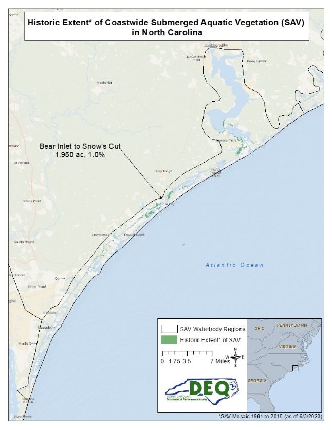
There have been various mapping projects over the last 40+ years by several universities, and state and
federal agencies. The data sources, mapping years, methodology, and extent of each individual mapping
event is described in table X.4. These individual mapping events compiled together make up the
historically known presence and suitable habitat of SAV along NC’s coast, suggesting a historic extent of
approximately 191,155 acres of SAV in public trust waters in coastal NC (Table X.5 and Figures X.1-X.9).
Additional mapping and monitoring of fresh and brackish SAV have occurred with hydroacoustic surveys,
the establishment of sentinel sites in recent years in the Neuse and Pamlico rivers and Albemarle
Sound, 22 and a coastwide aerial photography mapping event that occurred in 2019 and 2020 with
funding from DEQ and APNEP. As these more current data layers become available they will be
incorporated into this mosaic of NC SAV mapping events to better inform the known historic and current
extent of SAV in NC.
Table X.4 The data sources, mapping years, methodology, and extent of each individual SAV mapping
events along the North Carolina Coast from 1981 to 2015.
 Data Source                  Mapping Year(s)          Methodology                                       Mapping Extent
                                                       Maps of SAV were created from                     May 1981: Bogue and Core sounds
                                                       aerial natural color photography
  Carraway & Priddy
                                      1981             accompanied by ground truth data
       (1983)
                                                       for verification including location
                                                       and density. Link to report
                                                       SAV was delineated and mapped                     1990: Currituck, Albemarle and
                                                       from natural color aerial                         Roanoke/Croatan
                                                       photography with a minimum                        1991: Pamlico River Estuary, Neuse
                                  1983, 1985,          mapping unit of 20m. Accompanying                 River Estuary, western Pamlico Sound
   Ferguson & Wood
                                  1988, 1990,          field inventories were conducted                  and Albemarle
        (1994)
                                     1992              within study regions to verify SRV                1992: Pamlico River, Core and Bogue
                                                       signatures and species distribution               and parts of eastern Pamlico Sound,
                                                       and composition.                                  western Pamlico Sound, Albemarle
                                                       Link to report                                    (Perquimans River)
   Division Water                                      Maps from aerial photography                      Neuse River and tributaries
                                      1998
 Quality (DWQ) 1998
  Eastern Carolina                                     Maps from aerial photography                      Albemarle and Currituck sounds
                              2002-2003, 2006
  University (ECU)
                                                       Aerial photography from July 2005                 Southern shore of Albemarle Sound
 North Carolina State
                                      2005             accompanied by ground truth data                  including Bull Bay to northern Croatan
  University (NCSU)
                                                       Link to project summary                           Sound
                                                       Maps from interpolated transect                   2005 & 2006 (June-September): major
    Division Water                                     data. SAV was observed and                        tributaries of Neuse and Pamlico Rivers
     Quality Rapid                2005-2008            collected using a garden rake from                2007 (May-August): Neuse and Pamlico
    Response Team                                      boat, traveling along the shoreline.              Rivers and tributaries
                                                       Link to 2005 Report and2007 Report

of the southeastern United States: aquatic communities. John Wiley and Sons, Inc., NY
22 Luczkovich, J.J., 2016. Submerged Aquatic Vegetation SONAR Mapping Surveys in low-salinity habitats: Pamlico River. Final Report to Coastal

Recreational Fishing License Fund. Grant No. 2015-H-048 NC Division of Marine Fisheries, Morehead City NC;
Luczkovich, J.J, and H. Zenil. 2015. Low-Salinity SAV Mapping in 2014 and 2015 using CRFL SONAR and video protocols. Preliminary Report to
the Coastal Recreational Fishing License Fund. NC Division of Marine Fisheries, Morehead City, NC;
Luczkovich, J.J., 2018. Submerged Aquatic Vegetation (SAV) SONAR Mapping Surveys in low-salinity habitats: Neuse River. Final Report to
Coastal Recreational Fishing License Fund. Task Order # 6795. NC Division of Marine Fisheries, Morehead City NC
Zenil, H. 2020.

                                                                                                                                             8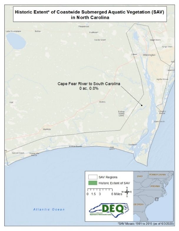
Data Source                Mapping Year(s)   Methodology                               Mapping Extent
                                              Field survey’s consisting of visual       Mouth of the Neuse River near Point of
   Marine Corps Air                           observations and underwater               Marsh.
                                   2007
 Station Cherry Point                         cameras and aerial survey analysis of
                                              hyperspectral imagery. Link to report
                                              SAV was mapped along the coast of         This extent encompasses the coastal
                                              NC and northward into Back Bay,           zone that lies within the APNEP
                                              Virginia by manually digitizing visible   regional boundary (Bogue Inlet north
                                2006-2008
                                              SAV from remotely-sensed imagery.         to Back Bay), as well as that which is
  Albemarle Pamlico
                                              Link to metadata                          outside of that boundary (Bogue Inlet
  National Estuarine
                                                                                        south to Masonboro Inlet).
   Partnership (SAV
                                              SAV was mapped along the coast of         This extent encompasses the high-
       Partners)
                                              NC by manually digitizing visible SAV     salinity coastal zone that lies within the
                                2012-2013     from remotely-sensed imagery. Link        APNEP regional boundary (Hwy. 64
                                              to metadata                               Bridge of Roanoke Sound south to
                                                                                        Bogue Inlet).
                                              SAV was mapped along the Southern         This extent encompasses the high-
                                              coast of NC by manually digitizing        salinity coastal zone of Onslow Bay
 DEQ, DOT, & NOAA                  2015
                                              visible SAV from remotely-sensed          that lies south of the APNEP regional
                                              imagery. Link to metadata                 boundary.

Table X.5 Historical extent of submerged aquatic vegetation (SAV) in North Carolina (SAV Mosaic 1981 to
2015 (Figures X.1-X.9).
 Salinity          SAV                                                         Historic        Percent of Historical
 Zone              Region #        SAV Region Name                           Extent* (ac)          Extent* (%)
 Low                   1           Currituck and Back Bay                         21,613                       11.3
 Low                   2           Albemarle Sound                                12,872                         6.7
 Low                   3           Tar-Pamlico & Neuse rivers                       4,581                        2.4
 High                  4           Pamlico Sound                                      712                        0.4
 High                  5           Roanoke Sound to Ocracoke Inlet               101,739                       53.2
 High                  6           Core Sound                                     36,862                       19.3
 High                  7           Bogue Sound                                    10,826                         5.7
 High                  8           Bear Inlet to Snow's Cut                         1,950                        1.0
 High/Low              9           Cape Fear River to SC line                           0                        0.0
 Total                                                                           191,155                      100.0
 *SAV Mosaic 1981 to 2015 (as of 6/3/2020)

                                                                                                                       9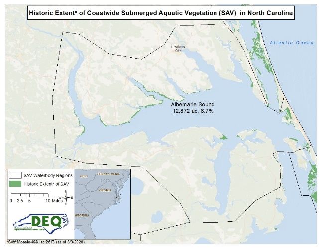
Figure X.1. Known historic extent of Submerged aquatic vegetation in North Carolina, mapped from
1981 to 2015. Absence of SAV does not suggest actual absence, as surveys have not been conducted in
all areas. Presence of SAV does not reflect current state, as data dates to 1981.

                                                                                                  10
Figure X.2. Known historic extent of Submerged aquatic vegetation in NC, mapped from 1981 to 2015 in
Currituck and Back Bay. Absence of SAV does not suggest actual absence, as surveys have not been
conducted in all areas. Presence of SAV does not reflect current state, as data dates to 1981.
11Figure X.3. Known historic extent of Submerged aquatic vegetation in NC, mapped from 1981 to 2015 in Albemarle Sound. Absence of SAV does
not suggest actual absence, as surveys have not been conducted in all areas. Presence of SAV does not reflect current state, as data dates to
1981.
12Figure X.4. Known historic extent of Submerged aquatic vegetation in NC, mapped from 1981 to 2015 in
Tar-Pamlico and Neuse rivers. Absence of SAV does not suggest actual absence, as surveys have not
been conducted in all areas. Presence of SAV does not reflect current state, as data dates to 1981.
13Figure X.5. Known historic extent of Submerged aquatic vegetation in NC, mapped from 1981 to 2015 in
Pamlico Sound. Absence of SAV does not suggest actual absence, as surveys have not been conducted in
all areas. Presence of SAV does not reflect current state, as data dates to 1981.
14Figure X.6. Known historic extent of Submerged aquatic vegetation in NC, mapped from 1981 to 2015 in Core Sound. Absence of SAV does not
suggest actual absence, as surveys have not been conducted in all areas. Presence of SAV does not reflect current state, as data dates to 1981.
15Figure X.7. Known historic extent of Submerged aquatic vegetation in NC, mapped from 1981 to 2015 in Bogue Sound. Absence of SAV does not
suggest actual absence, as surveys have not been conducted in all areas. Presence of SAV does not reflect current state, as data dates to 1981.
16Figure X.8. Known historic extent of Submerged aquatic vegetation in NC, mapped from 1981 to 2015 in
Bear Inlet to Snows Cut. Absence of SAV does not suggest actual absence, as surveys have not been
conducted in all areas. Presence of SAV does not reflect current state, as data dates to 1981.
17Figure X.9. Known historic extent of Submerged aquatic vegetation in NC, mapped from 1981 to 2015 in
Cape Fear River to the South Carolina line. Absence of SAV does not suggest actual absence, as surveys
have not been conducted in all areas. Presence of SAV does not reflect current state, as data dates to
1981.
18Mapping and monitoring low salinity SAV is more difficult compared to high salinity SAV due to low
water clarity in those low salinity areas of the estuary. However, despite the limited availability of
historical baseline data of low salinity SAV habitat, large fluctuations in SAV abundance have been
observed through hydroacoustic surveys and other sentinel site observations. Based on the most recent
hydroacoustic surveys of linear SAV extent along the 1-m isobath in the Neuse, Pamlico and Albemarle
river sub-estuaries, approximately 62% of the historical extent was absent from areas where SAV was
previously documented (Table X.6).
Table X.6. Linear Extent (LE) data along 1-meter isobaths line for low salinity SAV based on the SAV
mosaic and recent hydroacoustic surveys. 23
Percent
No change in Change in Change in change in
Historical* 2014-2017 SAV from SAV LE SAV LE SAV LE
Estuary SAV LE (m) SAV LE (m) historical (m) (gain) (loss) (loss)
Albemarle Sound 117,778 90,565 56,457 +34,108 -61,321 -52.06
Tar - Pamlico River 29,223 6,036 756 +5,280 -28,467 -97.41
Neuse River 10,512 9,519 2,821 +6,692 -7,685 -73.11
Total 157,513 106,120 60,034 +46,080 -97,473 -61.88
*From 1981-2015 SAV Mosaic
Although there is less known about low salinity SAV, there are some recurring themes. These include
large fluctuations in abundance, changes in species composition, a proliferation of non-native species,
persistent SAV, high turbidity, extreme weather events and large amounts of precipitation, and
fluctuations in salinity. This all represents an important and needed effort to develop numeric nutrient
criteria, so that progress on water quality improvements can be made for the benefits of SAV. 24
The high salinity seagrasses appear to be in better condition than the low salinity SAVs. There is a good
baseline of data on distribution and abundance for most of the high salinity SAV resource, along with a
good understanding of species composition, persistence and resilience. However, little water quality
data are collected and represents a crucial data gap.
The APNEP metric report: Extent of Submerged Aquatic Vegetation, High-Salinity Estuarine Waters (in
review), provides an analysis of SAV change based on spatial coverage detected from aircraft during two
survey periods: 2006-2007 (Survey 1) and 2013 (Survey 2). Survey 1 represents late spring aerial surveys
of Bogue and Back Sounds and fall aerial surveys between Roanoke Island and Barden’s Inlet. Survey 2
represents late spring aerial surveys between Roanoke Island and Bogue Inlet. For analysis purposes,
these coastal areas are broken down into three geographic regions. The northern region is between the
US Hwy 64 Bridge (Roanoke Island) to Hatteras Inlet; the central region is between Hatteras Inlet to
Ophelia Inlet; and the southern region is between Barden’s Inlet to Bogue Inlet.
All three regions showed declines in SAV acreage (Table X.7). However, the southern region, where
there is more development and higher population densities, declined by over 10% at a rate of 1.48% loss
per year. This annual loss rate in Bogue and Back Sounds equates to a projected loss of 20% of the SAV
resource in that region by 2025. 25 The northern and central regions are less developed, receive less
direct riverine input, and therefore had a lower estimated SAV acreage loss (Table X.7). It is concerning
23 APNEP (Albemarle-Pamlico National Estuary Partnership). 2020. Clean Waters and SAV: Making the Connection Technical Workshop summary
report. APNEP, 1601 Mail Service Center, Raleigh, NC https://apnep.nc.gov/our-work/monitoring/submerged-aquatic-vegetation-
monitoring/clean-waters-and-sav-making-connection
24 Ibid, 23
25 Ibid, 23
19that no regions gained SAV based on this assessment. SAV can grow at depths generally ≤ 2.0 m, yet
much of the available benthic habitat within this depth range was not occupied by SAV. An additional
concern is the amount of continuous beds that were converted to patchy beds. The biggest component
of the overall change in the northern region was the conversion of 15,327.5 acres (6,202.8 ha) of
continuous seagrass in Survey 1 to patchy seagrass in Survey 2. Approximately 2,100 acres of continuous
seagrass converted to patchy seagrass in the central and southern regions combined. 26
Table X.7. Net change in seagrass extent from 2006/2007 to 2013 (acres, hectares in parentheses)
(Continuous=70% or greater of substrate coverage; Patchy=discontinuous coverage between 5% and
70%; Unvegetated=less than 5% substrate coverage).27
Conversions Regions
North
(U.S. Hwy 64 Bridge at Central South
Roanoke Island to (Hatteras Inlet to (Barden’s Inlet to
From (Survey 1) To (Survey 2) Hatteras Inlet) Ophelia Inlet) Bogue Inlet)
Unvegetated Patchy 4,462.5 (1,809.5)↑ 4,386.5 (1,775.2)↑ 638.4 (258.4)↑
Unvegetated Continuous 202.8 (82.1) ↑ 150.4 (60.9)↑ 60.1 (24.3)↑
Gains +4,665.3 (1,888.0)↑ +4,536.9 (1,836.0)↑ +698.5 (282.7)↑
Continuous Unvegetated 1,894.9 (766.3)↓ 401.3 (162.4)↓ 88.4 (35.8)↓
Patchy Unvegetated 7,009.4 (2,836.6)↓ 4,782.3 (1,935.3)↓ 1,217.5 (492.7)↓
Losses -8,904.3 (3,603.3)↓ -5,183.6 (2,097.7)↓ -1,305.9 (528.5)↓
Net Loss 4,238.7 (1,715.3)↓ 646.7 (261.7) ↓ 607.4 (245.8)↓
Beginning Total (Survey 1) 70,861 (28,676) 24,132 (9,766) 5,850 (2,367)
Ending Total (Survey 2) 66,622.3 (26,960.7)↓ 23,485.3 (9,504.3) ↓ 5,242.6 (2,121.2) ↓
% Change -5.98↓ -2.67↓ -10.38↓
% Change yr-1 -1.08↓ -0.48↓ -1.48↓
Waycott et al. 28 performed a global assessment of 215 studies and found that seagrasses around the
world have been disappearing at a rate of 110 km2 yr-1 since 1980 with an overall global average rate of
decline of 1.5% y-1. Although NC decline rates within the northern and central regions are lower than
this global average, the higher rate of decline in Back and Bogue sounds (1.48% y -1) is comparable. 29
Bogue and Back Sounds may be especially vulnerable to impairment of water quality associated with
shoreline development and other anthropogenic impacts (boat wakes, dredging, fishing gears).
1.3.1. Management of SAV in North Carolina
There are several NC Department of Environmental Quality (DEQ) commissions that manage activities
that can directly and indirectly affect SAV. The NC MFC has authority over regulations of fishing practices
in coastal waters through the DMF. The NC Environmental Management Commission (EMC) has
authority over activities that affect water quality and are implemented by the NC Division of Water
Resources (DWR) and NC Division of Energy, Minerals, and Land Resources (DEMLR). The NC Coastal
Resources Commission (CRC) has authority over development activities within and adjacent to the public
trust and estuarine waters and coastal marshes which are implemented by the NC Division of Coastal
Management (DCM). Although the NC Wildlife Resources Commission (WRC) is not a formal participant
in development of the CHPP, they oversee regulation of boating in coastal and inland waters and fishing
26 Ibid, 16
27 Ibid, 16
28
Waycott, M., C. M. Duarte, T. J. B. Carruthers, R. J. Orth, W. C. Dennison, S. Olyarnik, A. Calladine, J. W. Fourqurean, K. L. H. Jr., A. R. Hughes,
G. A. Kendrick, W. J. Kenworthy, F. T. Short, and S. L. Williams. 2009. Accelerating loss of seagrasses across the globe threatens coastal
ecosystems. Proceedings of the National Academy of Science 106(30):12377-12381
29 Ibid 23; Ibid 16
20in inland waters and are involved with the three commissions as it concerns SAV and other fisheries
habitats. Additionally, the NC Department of Agriculture and Consumer Services (DA&CS) and NC
Department of Transportation (DOT) oversee activities that effect water quality via runoff.
1.3.2. Policies and Plans
There are several state, federal, and interstate policies and plans that directly or indirectly influence SAV
management, restoration, and protection in NC. Table X.8 provides information on four polices with
specific guidance as it pertains to monitoring, water quality, physical disturbance, land use and
development, restoration, research, and education in NC. The MFC SAV Policy recognizes the
importance of SAV to NC and calls for management guidelines to monitor and protect SAV. 30 The DENR
(now DEQ) Technical Guidance Document for the Protection of Submerged Aquatic Vegetation Habitat is
a document created to ensure regulatory review bodies consider SAV during the permit review
process. 31 The South Atlantic Fishery Management Council (SAFMC) Policy for Protection and
Enhancement of Estuarine and Marine Submerged Aquatic Vegetation (SAV) Habitat encourages the
South Atlantic states to assess the status and trends in SAV and consider establishing plans that
integrate monitoring and research, planning, management, education, and enforcement to protect and
revitalize SAV resources. 32 The Atlantic States Marine Fisheries Commission (ASMFC) Policy was
developed to communicate the necessity of conservation of coastal SAV resources because of the
importance of SAV habitat to managed fish species. 33
30
NC MFC (NC Marine Fisheries Commission). 2004. Policy Statement for the Protection of SAV. NC Division of Marine Fisheries, Morehead City,
NC
31 NCDENR (North Carolina Department of Environment and Natural Resources). 2012. DENR Technical Guidance Document for Protection of
Submerged Aquatic Vegetation Habitat. Raleigh, NC
32
SAFMC (South Atlantic Fishery Management Council). 2014. Essential Fish Habitat Policy Statements (revised and updated). South Atlantic
Fishery Management Council, Charleston, SC
33 Havel, L.N. and ASMFC Habitat Committee. 2018. Submerged Aquatic Vegetation Policy. ASMFC Habitat Management Series No. 15,
Arlington, VA
21Table X.8. Existing SAV management policies from regulatory agencies affecting North Carolina.
NC Marine Fisheries Commission 34 NC Department of Environmental South Atlantic Fishery Management Atlantic State Marine Fisheries
Quality 35 Council 36 Commissions 37
Assessment & In order to delineate and assess the Definition of SAV habitat is expanded for Develop and standardize imagery At a minimum, each member state should
Mapping distribution and health of SAV habitat, mapping and monitoring purposes. acquisition and resource mapping ensure the implementation of an SAV
SAV beds need to be mapped and protocols, with regional modification as resource assessment and monitoring
monitored. necessary to achieve effective results program which will provide a continuing
(Yarbro and Carlson 2013). quantitative evaluation of SAV
Develop and maintain a GIS database for distribution and abundance and the
essential habitat including SAV and use supporting environmental parameters.
that information for assessment of trends
in SAV extent (e.g., SIMM or OBIS-
SEAMAP).
Water Quality Minimize nutrient and sediment loading Evaluate water quality criteria needed to Support and promote the development of
to coastal waters that support existing support SAV survival and growth and water quality standards by the EPA and
SAV to protect adequate water quality as support policy making to manage quality member states that can be implemented
defined by water-column clarity in and quantity of surface runoff. to protect SAV habitat (i.e. light
standard measurement units. Review of state water quality standards attenuation, total suspended solids,
and rules to determine if changes are chlorophyll a, dissolved inorganic
needed to protect and enhance SAV. nitrogen, dissolved inorganic phosphorus,
critical life period).
Fishing Gear All SAV needs to be protected from all Dredging directly alters the bottom to Review and modification of state and In partnership with NOAA Fisheries and
Disturbance bottom-disturbing fishing and conditions unfavorable for SAV growth or federal rules to ensure protection of SAV USFWS, develop technical guidelines and
recreational gear. Sufficient buffer zones recolonization and should be avoided in from impacts such as dredging, propeller standards to objectively evaluate fishing
surrounding SAV beds should also be existing and suitable bottom that has scarring, marina and pier construction, gear, propeller scarring, dredging, coastal
protected from disturbance to prevent supported SAV in the past. and bottom-disturbing fishing activity. construction, and bottom fishing
impacts of sediments on growing SAV. impacting, and develop standard
mitigation strategies.
Docks & Piers Piers and docking facilities can potentially Encourage states to minimize impacts to Encourage citizen involvement in impact
impact SAV through construction impacts, SAV by developing design criteria for reporting.
shading, and indirect impacts from boat docks and piers which establish minimum
wakes and prop dredging. Floating docks height, maximum width and materials.
block more sunlight due to the solid
surface and lower position over the
bottom and in shallow water may rest on
top of the vegetation. The design, size,
and location of the docking facility will
determine the level of impact to SAV
habitat.
34 Ibid, 30
35 Ibid, 31
36 Ibid, 32
37 Ibid, 33
22NC Marine Fisheries Commission 34 NC Department of Environmental South Atlantic Fishery Management Atlantic State Marine Fisheries
Quality 35 Council 36 Commissions 37
Protection Provide adequate safeguards to prevent Field reps and permit reviewers should Development of economic analyses on
from direct (or indirect) impacts from consider the potential impacts of the economic benefits of protecting and
Development development projects adjacent to or proposed activities to SAV habitat on a enhancing SAV habitat.
connected to SAV. case-by-case basis. Reviewers should
Assess cumulative impacts of land use consider the level of impact of the specific
and development changes in the proposed activity on SAV habitat and the
watershed affecting SAV to identify the level of scientific documentation
potential impact. Require identification supporting the habitat determination
of cumulative impacts as a condition of (currently exists, suitable SAV habitat
development of permit applications. conditions and documented to support
SAV within the past ten years).
Habitat Require compensatory mitigation where Shoreline stabilization practices that Investigate effective restoration Protection is preferred over restoration.
Restoration impacts are unavoidable. Initiate result in increased wave energy regimes, techniques, including ecological function Restoration programs should include
restoration programs to recoup and/or turbidity, or sedimentation can and cost/benefit. establishment of habitat quality necessary
enhance lost SAV habitat. potentially impact SAV habitat. Shoreline Development of SAV restoration for SAV prior to restoration. Restoration
stabilization methods should utilize the guidelines for both high and low salinity methods should incorporate scientifically
method that would cause the least SAV to accelerate successful, cost- based protocols. Restoration goals should
expected impact to SAV habitat if effective SAV restoration. consider potential and historical SAV
possible. spatial footprint.
Education & Educate landowners adjacent to SAV, Design of education programs to heighten ASMFC and member states should
Outreach boaters, and other potential interested the public’s awareness of the importance promote and support public education
parties about the value of SAV as a of SAV. An informed public will provide a and stewardship programs that will
habitat for many coastal fishes and firm foundation of support for protection increase the public’s knowledge of SAV,
invertebrates. and restoration efforts. its importance as fish habitat, and
commitment to SAV conservation.
Scientific Research and document causes and ASMFC and member states should
Research effects of SAV losses, including cumulative promote and support those research
impacts, watershed runoff, shoreline projects which will improve our
development, shading associated with knowledge of SAV and its benefits as fish
pier and dock, development, invasive habitat.
species, and extreme weather conditions
(drought, tropical storms, algal blooms,
etc.).
Research potential effect of climate
change on SAV habitat.
Regulations & Specific guidance for permits. The regulatory definition of SAV habitat ASMFC members should propose
Enforcement as: shallow water habitat with improvements necessary in state
Improvements appropriate sediment, depth, light regulation and management including
penetration and wave energy, including conditions pertaining to harvesting
areas without existing SAV. shellfish or finfish in SAV beds by use of
Review of existing regulations and mechanical means and the placement and
enforcement to determine their operations of aquaculture activities to
effectiveness. protect existing SAV beds.
Coordination with state resource and Encourage state agencies or departments
23NC Marine Fisheries Commission 34 NC Department of Environmental South Atlantic Fishery Management Atlantic State Marine Fisheries
Quality 35 Council 36 Commissions 37
regulatory agencies to ensure that with jurisdiction over construction
existing regulations are being enforced. activities to propose improvements
necessary in state regulation and
management of SAV habitats based on
the standards developed in the above
actions.
In addition to the policies described above, there are also various NC plans that address the importance of monitoring, protecting, and restoring
the state’s SAV resources. They are summarized below:
NC Wildlife Resources Commission Wildlife Action Plan (NCWAP)
This plan is a comprehensive planning tool used by the WRC to help conserve the state’s fish and wildlife species and their habitats. This includes
numerous recommendations for monitoring the state’s SAV. The WRC received approval from the U.S. Fish & Wildlife Service (USFWS) for
the comprehensive revision of the NCWAP on March 30, 2016. 38
Albemarle-Pamlico National Estuary Partnership (APNEP) Comprehensive Conservation and Management Plan (CCMP)
The APNEP CCMP was developed using the principles of ecosystem-based management (EBM) which includes consideration of human and
natural systems, an adaptive management framework, and meaningful engagement with the region’s citizens to find environmental
management and policy solutions. Protection and restoration efforts to improve water quality and SAV are addressed with an emphasis on
assessment and monitoring to facilitate adaptive management as more knowledge is gained in the system. 39
APNEP Submerged Aquatic Vegetation Partners Plan
This document provides a framework to guide actions and efforts in protecting and restoring SAV habitat through coordinated research,
monitoring, assessment and outreach activities. It also serves as a more detailed “step-down” document that can be used to implement
conservation measures specific to SAV in support of the CHPP, the WAP, and the CCMP. The goals, objectives, and actions of this plan must
utilize an ecosystem approach to maximize effectiveness and efficiency. 40
NC Aquatic Nuisance Species Management Plan
The purpose of the NC Aquatic Nuisance Species Management Plan is to improve the state’s ability to address aquatic invasive and aquatic
nuisance species with the goal of preventing and controlling their introduction, spread, and negative impacts. Within this plan, invasive aquatic
plant species, which can have an impact on native brackish water and high salinity SAVs, are addressed. Impacts of Water Quality Impairment to
38 NCWRC (NC Wildlife Resources Commission). 2015. North Carolina Wildlife Action Plan. Raleigh, NC
39 APNEP (Albemarle-Pamlico National Estuary Partnership). 2012a. Comprehensive conservation and management plan. APNEP, Raleigh, NC
40 APNEP (Albemarle-Pamlico National Estuary Partnership). 2012b. Submerged aquatic vegetation partners’ action plan for the NC and southern VA coast. APNEP, Raleigh, NC
24SAV. 41
1.3.3. Impacts of Water Quality Impairment to SAV
As noted earlier, SAV is especially sensitive to water quality impairment from nutrient and sediment
pollution and has been considered a “coastal canary”, serving as a valuable bio-indicator of the overall
health of our coastal ecosystems. 42 Global losses of SAV are estimated to be at over 29% during the last
century. 43 The impairment of water quality is one of the most widespread threats to SAV ecosystems. In
the U.S., SAV along the Atlantic seaboard has experienced significant declines directly or indirectly
attributed to the stressors associated with degraded water quality. 44
The majority of SAV loss can be attributed to large-scale eutrophication (nutrient enrichment) and
sedimentation, which reduces light penetration to the plants. 45 Eutrophication and/or increased
sediment loads impact light available for SAV by:
• Reducing water clarity with sediment or phytoplankton associated with algal blooms; 46
• Increasing epiphyte and/or drift algae coverage. 47
Eutrophication of shallow estuaries can lead to proliferation of ephemeral macroalgae and filamentous
green and brown algae and epiphytes that compete directly with SAV for nutrients and light. 48 Studies
have found that macroalgal biomass is directly related to increased nutrient levels and that SAV loss is
greater with increased macroalgae. 49 Once macroalgal blooms die, they decompose rapidly, increasing
nutrient levels in the water column, stimulating phytoplankton production, further reducing light, and
decreasing DO in the water and sediments. These have all been important factors in the decline of SAV
up and down the Atlantic seaboard.
Chlorophyll a is an indicator of phytoplankton production, where high concentrations in the estuary can
indicate algal blooms that in turn decrease light penetration, thus impacting SAV growth. In Albemarle
41 NCANSMPC (North Carolina Aquatic Nuisance Species Management Plan Committee) 2015. NC Aquatic Nuisance Species Management Plan.
Raleigh, NC
42
Ibid, 11
43
Ibid, 2; Ibid, 28
44 Costello, C.T. and J.W. Kenworthy. 2011. Twelve-year mapping and change analysis of eelgrass (Zostera marina) areal abundance in
Massachusetts (USA) identifies statewide declines. Estuaries and Coasts. 34:232-242;
Lefcheck, J.S, R.J. Orth, W.C. Dennison, D.J. Wilcox, R.R. Murphy, J. Keisman, C. Gurbisz, M. Hannam, J.B. Landry, K.A. Moore, C.J. Patrick, J.
Testa, D.E. Weller, and R.A. Batiuk. 2018. Long-term nutrient reductions lead to the unprecedented recovery of a temperate coastal region.
Proceedings of the National Academy of Sciences. 115. 201715798. 10.1073/pnas.1715798115
45 Ibid, 2;
Steward, J. S., and W. C. Green. 2007. Setting load limits for nutrients and suspended solids based upon seagrass depth-limit targets. Estuaries
and Coasts 30(4):657-670;
Ruhl, H.A and N.B. Rybicki. 2010. Long-term reductions in anthropogenic nutrients link to improvements in Chesapeake Bay habitat.
Proceedings of the National Academy of Sciences Sep 2010, 107 (38) 16566-16570. DOI: 10.1073/pnas.1003590107;
Greening, H., A. Janicki, E.T. Sherwood, R. Pribble, J.O.R Johansson. 2014. Ecosystem responses to long-term nutrient management in an urban
estuary: Tampa Bay, Florida, USA. Estuarine, Coastal and Shelf Science 151: A1-A16
46 Ibid, 44; Ibid, 45
47
Virnstein, R. W., and L. J. Morris. 1996. Seagrass preservation and restoration: a diagnostic plan for the Indian River Lagoon. St. Johns River
Water Management District, Palatka, Fl;
Ibid, 44
48 Neckles, H. A., R. L. Wetzel, and R. J. Orth. 1993. Relative effects of nutrient enrichment and grazing on epipyte-macrophyte (Zostera marina
L.) dynamics. Oecologia (93):285-295;
McGlathery, J. K. 2001. Macroagal blooms contribute to the decline of seagrass in nutrient-enriched coastal waters. Journal of Phycology
(37):453-456;
Herrera-Silveria, J.A. and S.M. Morales-Ojeda. 2009. Evaluation of the health status of a coastal ecosystem in southeast Mexico: Assessment of
water quality, phytoplankton and submerged aquatic vegetation. Marine Pollution Bulletin 59:72-86.
49
Valiela, I., J. H. J. McClelland, P. J. Behr, D. Hersh, and K. Foreman. 1997. Macroagal blooms in shallow estuaries: Controls and
ecophysiological and ecosystem consequences. Limnology and Oceanography 45(5):110-1118;
Hauxwell, J., J. Cebrian, C. Furlong, and I. Valiela. 2000. Macroalgal canopies contribute to eelgrass (Zostera marina) decline in temperate
estuarine ecosystems. Ecology 82:1007-1022.
25Sound there has been a subtantial increase in Chlorophyll a over time, which is associated with
increasing reports of cyanobacteria blooms over the same time period. Concentrations have fluctuated
over the last twenty years across the Albemarle-Pamlico estuarine systems. Additionally, remote sensing
information corroborates a rapid increase in cyanobacteria biomass throughout the Albemarle Sound
region.
Colored dissolved organic matter (CDOM) is primarily leached from decaying detritus and organic matter
and gives water a brownish color. Light penetration is greatly reduced in waters with high CDOM
concentrations. In general, CDOM concentrations are higher in fresh and oligohaline waters compared
to polyhaline waters. In the Neuse River estuary, CDOM is increasing and may be linked to the salinity
regime. As such, declines in water quality for this region could be harder to manage because they are
not just directly related to nutrient enrichment.50
1.3.4. Case Studies of Water Quality Improvements that Benefit SAV in Chesapeake and Tampa Bays
Water quality impairment is a serious but manageable threat to SAV in NC. Water clarity for light
penetration is necessary for SAV growth, and SAV survival is impacted by suspended sediments and
nutrients. Coastal development expansion combined with increases in the intensity and severity of
storm events, and rising sea levels, are resulting in runoff and associated increases in turbidity and
nutrient loading. However, in Chesapeake Bay and Tampa Bay, improvements in water quality and
resulting improved water clarity have in turn improved environmental conditions for SAV survival,
growth, and propagation, allowing each system to reach targeted SAV acreage goals.
Chesapeake Bay
Loss of SAV in the shallow waters of the Chesapeake Bay from the early 1960s through the mid-1980s
has been documented over time, resulting from nutrient over-enrichment and increased suspended
sediment and the associated reduction of light availability to the plants. 51 Since the 1950s, the
population grew around the bay, more than doubling from 8 million to over 18 million by 2020.
Consequently, land development doubled and correspondingly impervious surfaces, fertilizer use
(domestic and agricultural), and livestock production increased. These factors impacted water quality in
the bay from nutrient enrichment and sediment loading. This, in turn, increased light attenuation
(reduction) by suspended sediments, higher phytoplankton populations, and epiphytic fouling on SAV
blades resulting in significant SAV population decreases. 52
Early efforts were made to reduce point source nutrient loads, especially from wastewater treatment
plants (WWTP). Examples include the Upper Patuxent River and Potomac River where WWTP upgrades
to improve nitrogen and phosphorus removals were implemented in the late 1980s and early 1990s. 53
Both areas were devoid of SAV until these WWTPs were upgraded. SAV has since reappeared
downstream of these plants and the reappearance has been linked to the reductions in wastewater
50 Ibid, 23
51 Ibid, 19
52 Ibid, 44;
Jordan, T.E., D.E. Weller, C.E. Pelc. 2018. Effects of local watershed land use on water quality in mid-Atlantic coastal bays and subestuaries of
the Chesapeake Bay. Estuaries and Coasts 41: S38-S53;
Orth, R.J., W.C. Dennison, C. Gurbisz, M. Hannam, J. Keisman, J.B. Landry, J.S. Lefcheck, K.A. Moore, R.R. Murphy, C.J. Patrick, J. Testa, D.E.
Weller, D.J. Wilcox, R.A. Batiuk. 2019. Long-term Annual Aerial Surveys of Submersed Aquatic Vegetation (SAV) Support Science, Management,
and Restoration. Estuaries and Coasts 2019:1-16 https://link.springer.com/content/pdf/10.1007/s12237-019-00651-w.pdf
53 Ruhl, H.A and N.B. Rybicki. 2010. Long-term reductions in anthropogenic nutrients link to improvements in Chesapeake Bay habitat.
Proceedings of the National Academy of Sciences Sep 2010, 107 (38) 16566-16570. DOI: 10.1073/pnas.1003590107;
Ibid, 19.
26You can also read