Causal links between the North American heatwave and European and Chinese floods
←
→
Page content transcription
If your browser does not render page correctly, please read the page content below
Causal links between the North American
heatwave and European and Chinese floods
Thomas Mortlock and Stuart Browning

An unprecedented heat dome trapped hot air over much of southern British Columbia, Canada and
Oregon and Washington in the United States, in the week of June 25 – July 1, causing widespread
temperature anomalies of over 20 degrees and over 500 excess deaths (see our Briefing Note here).
Two weeks later, parts of northwest Europe experienced some of the worst flooding in living
memory and at least 170 deaths (at the time of writing).

Figure 1. Severe flooding hit Areas of Germany, Belgium, Luxembourg, the Netherlands and Switzerland in July 2021.
Source: BBC (2021).

The Ahr River, a tributary of the Rhine in western Germany, was a major source of fluvial flooding.
Post-event images illustrate the extreme scale of the flooding. Flood levels reached 8 m in areas, with
the previous flood of record reaching only 3.7 m (Stefan Geisen, KPMG, pers comms). Discharge in
the Meuse River – which flows through the Netherlands, Belgium, Luxembourg, and France –
exceeded 3,000 m3/s, which has only happened twice, in December 1925 and December 1993, since
measurements began in 1911 (Simone de Kleermaeker, Deltares, pers. comms). For such a high flow
to occur during summer is highly unusual, with the former maximum summer discharge of the Meuse
being 2,100 m3/s. Potential insured losses of the flooding may reach up to EUR 5 billion by some
estimates (Insurance Insider, 2021). Within the same week, to the north, Northern Ireland
experienced its hottest day on record (31.2 °C), and the UK issued its first Extreme Heat alert for the
south-west region of England and Wales.

Barely a week later, extreme flooding occurred in the central Chinese city of Zhengzhou, Henan
province. Over a three-day period, 617 mm of rain fell in Zhengzhou, a level seen only ‘once in a

                                                                                       Briefing Note 449– page 1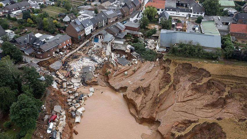
thousand years’ according to the Zhengzhou weather bureau (Reuters, 2021). Around 100,000 people
were evacuated, and widespread flooding and economic disruption ensued (Figure 2). Henan
province is home to the world’s biggest production base for iPhones and a major hub for food
production and heavy industry (Bloomberg, 2021). Just days before the devastating floods, Henan
province endured heatwaves that swept across several industrial regions, threatening power
outages.

Figure 2. Rescue workers evacuating residents on a flooded road following heavy rainfall in Zhengzhou, Henan
province, China July 22, 2021. Source: Aly Song (2021).

Interconnected disasters and the jet stream
While separated thousands of kilometres and several weeks apart, the North American heatwave,
European and Chinese floods were driven by the same causal mechanism – incursions of the pan-
hemispheric Rossby wave, or jet stream.

Around the mid-latitudes of the northern hemisphere, weather systems – both dry and wet – are
carried along by the jet stream, a current of fast-flowing air in the lower atmosphere. The jet stream
is a type of Rossby or planetary wave (which are also found in the ocean as well as the atmosphere).

The jet stream generally keeps a steady flow of weather moving across the mid-latitudes. This means
that any low-pressure system – or intervening high-pressure system that brings clear, fine and sunny
conditions – will generally only be kept in place for several days before transitioning to the next
system.

                                                                                      Briefing Note 449– page 2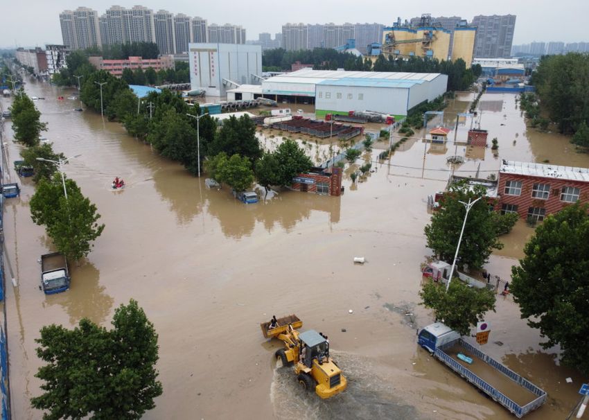
However, sometimes weather systems can get stuck in place for an extended period of time. This is
known as “blocking”. Across the Northern Hemisphere mid-latitudes (encompassing much of North
America, Northwest Europe and Central China), blocking can occur when the jet stream becomes
highly sinuous and “traps” a weather cell in place, keeping it in position for days to weeks. High
sinuosity of the jet stream can also draw weather into an area from different latitudes that is highly
unusual for that location (Figure 3).
Figure 3. There are four main jet streams: two polar jet streams and two subtropical jet streams. Inset illustrates
how sinuosity of the polar jet stream can cause anomalous weather incursions. Source: NOAA/JPL-Caltech (2021).
How are the Chinese and European floods and North American heatwave connected?
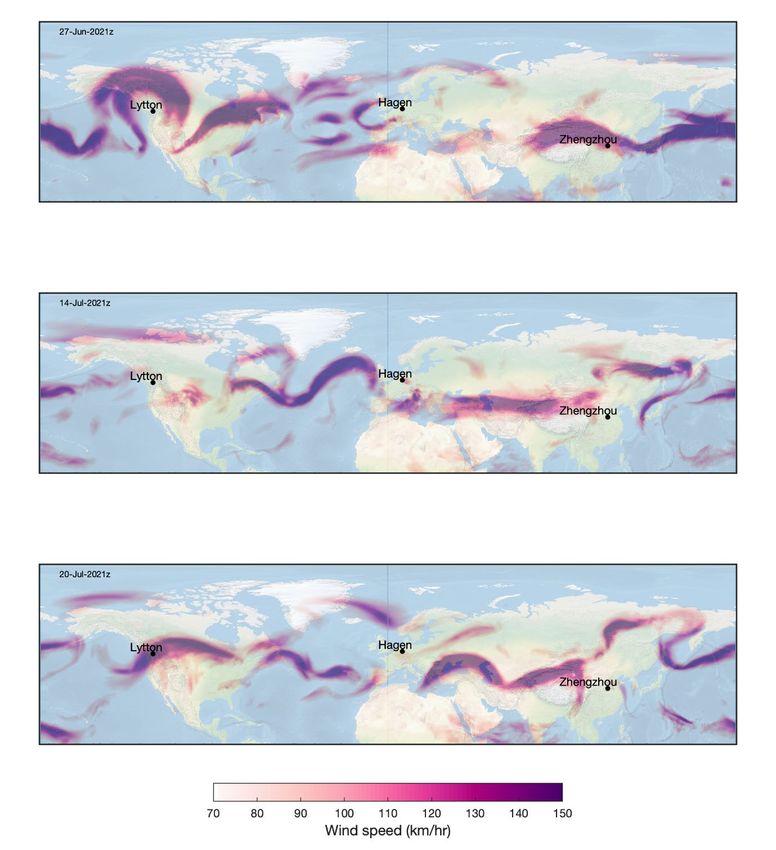
Figure 4 illustrates the eastward progression of the northern hemisphere longwave pattern over a
two-week period from the 27th of June to the 14th of July. The top panel shows a high amplitude wave
over western Canada, this pattern is known as an Omega block, due to the shape of the wave
resembling the Greek letter omega (Ω). Omega blocks consist of a strong high-pressure system with
low pressure systems to the east and west. They can be quite persistent and cause heavy rain and
flooding in locations under the low-pressure systems, and heatwave conditions in locations under the
blocking high. In this case the Omega block was the primary driver of the Western Canada heatwave.
Briefing Note 449– page 3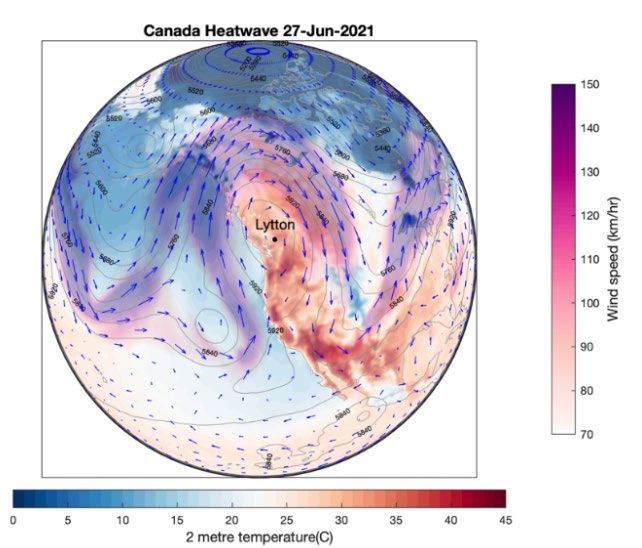
Figure 4. Wind speeds at 200hpa (~12km altitude) illustrating the progression of the long wave pattern from the
27th of June to the 20th of July. Top panel shows omega pattern contributing to the heatwave over Canada; middle
panel shows pattern contributing to flooding in NW Europe in mid-July; and bottom panel shows the split in the
Jetstream during flooding in Zhengzhou. Source: Image produced by Risk Frontiers using ERA5 reanalysis data.

                                                                                     Briefing Note 449– page 4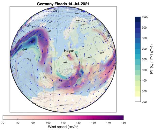
Figure 5 shows the synoptic situation over Western Canada on July 27th. The meridional longwave
pattern has set up a blocking high pressure system and is driving large scale latitudinal air mass
exchange, with warmer tropical air advected to Western Canada and cooler arctic air advected to
central USA.

Over the following two-week period this Rossby wave progressed eastward until the 14th of July at
which time it was situated to the west of Europe. The trough to the east of the Rossby wave was the
primary driver of flooding in Western Europe. Figure 5 shows the long wave pattern over Europe. In
this case the anticyclonic circulation around the trough is advecting warm moisture-laden air from the
Mediterranean into Western Europe.

Over the past month a slowing of the Northern hemisphere jet has resulted in a more meridional
circulation with higher amplitude Rossby waves. As these waves progress from west to east they are
driving extreme weather events across the northern hemisphere continents. This same perturbation
in the longwave pattern is now over China and is likely to have contributed to the extreme flooding in
Henan province.

Figure 5. Left panel: Synoptic situation over Western Canada on July 27th. The meridional longwave pattern has set
up an Omega blocking high pressure system and is driving large scale latitudinal air mass exchange, with warmer
tropical air advected to Western Canada and cooler arctic air advected to the central USA. The figure shows wind
speed and direction at 200hpa (~12km altitude), 500hpa Geopotential heights, and surface air temperature. Right
panel: Synoptic situation associated with extreme flooding in Western Europe. In this case the blocking high
pressure is to the west of Europe and is feeding a deep trough over Germany. Anticyclonic circulation around the
trough is advecting warm moisture laden air from the Mediterranean into Western Europe, as indicated by the
Integrated Water Vapour transport (IVT). The figure shows wind speed and direction at 200hpa (~12km altitude),
500hpa Geopotential heights, and IVT. Source: Image produced by Risk Frontiers using ERA5 reanalysis data.

The importance of peril correlation and compound disasters
The North American heatwave and European and Chinese floods highlight the importance of
incorporating the physical relationships and natural correlations that exist between weather
extremes. Risk assessments have typically treated weather extremes as independent events,
uncorrelated in space and time, either across different types of extremes in a given location or for a
given extreme occurring in different locations. In doing so, there is the potential for impacts (or
losses, in dollar terms) to be underestimated and the resilience to compound disasters to be lacking.

                                                                                       Briefing Note 449– page 5
Catastrophe loss (CAT) models are decision support tools used widely within the (re)insurance
industry for natural peril pricing and aggregate exposure management, and more recently across the
private and public sector to understand the financial impacts of physical climate risks.

Risk Frontiers continues to develop a fully correlated Australia hazard event set across all weather-
related CAT models which include flood, fire, tropical cyclone, and hail. The intention is to better
capture the year-on-year variability of modelled losses by coupling or de-coupling peril occurrence in
any given year.

The latest series of events in the Northern Hemisphere highlights that the correlation and
compounding potential between individual climate hazards remains an important but under-
represented aspect of climate risk assessment and peril pricing.

The role of Arctic warming
This briefing note will be followed by a synopsis on the potential role of climate change and Arctic
warming on the occurrence of extreme weather patterns induced by the jet stream. This assessment
is being prepared by Risk Frontiers and the Australian Research Council Centre of Excellence for
Climate Extremes (CLEX) of which Risk Frontiers is a Partner Organisation.

For a copy of this article, or more information on Risk Frontiers’ natural hazard and physical climate
risk modelling services, or our recent research into compound disasters, please contact
info@riskfrontiers.com.

References
BBC (2021). Germany floods: Dozens killed after record rain in Germany and Belgium.
https://www.bbc.com/news/world-europe-57846200

Bloomberg (2021). China’s ‘iPhone City’ Relocates 100,000 After Floods Leave 12 Dead.
https://www.bloomberg.com/news/articles/2021-07-20/major-chinese-city-hit-by-flooding-after-record-
rainfall

Insurance Insider (2021). GDV pegs German flooding insured loss at EUR4bn-EUR5bn.
https://www.insuranceinsider.com/article/28tkda2cxdn4j6e62x1j4/gdv-pegs-german-flooding-insured-
loss-at-eur4bn-eur5bn

NOAA/JPL-Caltech (2021). Image retrieved from: What is the Jet Stream? https://scijinks.gov/jet-
stream/. Accessed 22 July 2021.

Reuters (2021). At least 25 dead as rains deluge central China's Henan province.
https://www.reuters.com/world/china/heavy-rainfall-kills-12-central-chinas-henan-provincial-capital-
xinhua-2021-07-20/

                                                                              Briefing Note 449– page 6
You can also read