BANKWEST STADIUM FLOOD EMERGENCY RESPONSE PLAN - VENUESLIVE
←
→
Page content transcription
If your browser does not render page correctly, please read the page content below

VenuesLive

Bankwest Stadium

Flood Emergency Response Plan

Bankwest Stadium

             F LOOD E MERGENCY R ESPONSE P LAN

                                           for

                                   VenuesLive

                                           by

                        Molino Stewart Pty Ltd
                            ACN 067 774 332

                                     MARCH 2019

                MOLINO STEWART PTY LTD ABN 95 571 253 092 ACN 067 774 332

PO BOX 614, PARRAMATTA CBD BC, PARRAMATTA NSW 2124 TEL: (02) 9354 0300 FAX: (02) 9893 9806

                                www.molinostewart.com.au
DOCUMENT CONTROL

Document Reference        1091 Bankwest Stadium FERP Report_Final_v2

Project                   Bankwest Stadium

Document Type             Flood Emergency Response Plan

Author                    Filippo Dall’Osso, Steve Molino

REVISION HISTORY

Date          Version Name               Comments

08/03/2019      1    Filippo Dall’Osso   Draft for Internal review

08/03/2019     1.1   Steven Molino       Draft for Client review

08/03/2019      2    Steven Molino       Final

DOCUMENT APPROVAL

For Molino Stewart

Name                         Steven Molino

Position                     Principal

Venues Live

Name                         Simon Davies

Position                     General Manager Asset Management

ii                                                                     VenuesLive

CONTENTS

1   INTRODUCTION                                            1
    1.1 Background                                          1
    1.2 Site Details                                        1
        1.2.1 Locality                                      1
        1.2.2 Site Layout                                   1
        1.2.3 Access                                        2
        1.2.4 Topography                                    2
        1.2.5 Operation                                     3

2   FLOOD BEHAVIOUR                                        10
    2.1 Flood Generating Weather                           10
    2.2 Flood Probabilities                                10
    2.3 Flooding of the Site                               10
        2.3.1 Flood Extent and Levels                      11
        2.3.2 Frequency of Flooding                        14
        2.3.3 Flood Rate of Rise and Duration              14

3   FLOOD FORECASTS AND WARNINGS                           15
    3.1 Bureau of Meteorology (BoM)                        15
    3.2 Floodsmart                                         16
    3.3 Observed Flood Levels                              18

4   EMERGENCY PREPAREDNESS AND RESPONSE CONSIDERATIONS     19
    4.1 Evacuation Modelling                               19
        4.1.1 Scope                                        19
        4.1.2 Assumptions                                  19
        4.1.3 Evacuation Time Needed                       21
        4.1.4 Evacuation Timeline                          21
    4.2 Consultation                                       22
        4.2.1 Evacuation Challenges                        23
        4.2.2 SIP Challenges                               24

5   FLOOD EMERGENCY RESPONSE PLAN                          28
    5.1 Emergency Response Philosophy                      28
        5.1.1 Priorities                                   28
        5.1.2 Alert Modes                                  28
    5.2 Responsibilities                                   30
        5.2.1 NSW State Emergency Services                 30
        5.2.2 The Emergency Organisation Committee (ECO)   30
        5.2.3 Chief Warden                                 31
        5.2.4 Area Wardens and Wardens                     31
        5.2.5 Staff and Contractors                        31

Bankwest Stadium - Flood Emergency Response Plan                iii
5.2.6 Patrons, Entertainment Personnel and Media                                  31
     5.3 Communication Methods                                                             31
         5.3.1 The Emergency Committee Organisation (ECO)                                  31
         5.3.2 Chief Warden                                                                32
         5.3.3 Patrons                                                                     32
     5.4 What do to Before, During and After a Flood                                       32
         5.4.1 White Alert Mode – Normal Operations                                        32
         5.4.2 Yellow Alert Mode                                                           33
         5.4.3 Orange Alert Mode                                                           33
         5.4.4 Red Alert Mode                                                              35
         5.4.5 Black Alert Mode                                                            37
         5.4.6 Green Alert Mode                                                            41

REFERENCES                                                                                 43

APPENDICES
Appendix A – Flood Actions Checklist

Appendix B – Emergency Contacts List

 LIST OF FIGURES
Figure 1. Location of the site                                                              4
Figure 2. Level L00 – Pitch and Services                                                    5
Figure 3. Level L01 - Concourse                                                             6
Figure 4. North and East elevation                                                          7
Figure 5. South and West elevation                                                          8
Figure 6. Location of the 14m AHD topographic contour line with respect to level L00.       9
Figure 7. Flood depths and velocities in the 20% AEP event (adapted from CSS, 2018)        12
Figure 8. Flood extents and levels adopted by the City of Parramatta Council               12
Figure 9. Flood hazard adopted by the City of Parramatta Council                           13
Figure 10. PMF hydrograph near O’Connell Street showing peak levels of the 5% and 1%
          AEP (in black) and floor levels at the site (in red)                             14
Figure 11. Flood warning areas as defined in the Floodsmart war system                     17
Figure 12. Pedestrian Evacuation Route                                                     21
Figure 13. Evacuation timeline and trigger levels plotted on the PMF hydrograph near
          O’Connell Street                                                                 23
Figure 14. Position of flood gates and retaining wall to water proof the southern access
          points to level L00                                                              25
Figure 15.Estimated relationship between peak flood levels and Average Recurrence
          Interval of flood events upstream of O’Connell Street.                           26

iv                                                                                         VenuesLive
LIST OF TABLES
Table 1. Annual probabilities of a large flood happening while an event is taking place
          within the site                                                                 14
Table 2. Flood smart warning system: types of warning messages                            16
Table 3. Flood warning types relevant to different items within the site as per the
           Floodsmart system                                                              17
Table 4. Alert Mode Table setting triggers for each Alert Mode. A single trigger is
          necessary and sufficient to activate the relevant Alert Mode.                   29

Bankwest Stadium - Flood Emergency Response Plan                                               v
1 INTRODUCTION 1.2 SITE DETAILS
1.2.1 Locality
1.1 BACKGROUND
The stadium is located in Parramatta, between
VenuesLive Pty Ltd is taking over O’Connell Street and the Parramatta River,
management of the Bankwest Stadium, due to north-west of the Marsden Weir. It is located
finish construction in early 2019. The stadium on the parcels previously occupied by the
is located on O’Connell Street Parramatta, demolished Parramatta Stadium and the
next to the Parramatta River, and has been Parramatta Pool.
previously known as Parramatta Stadium.
It is bounded by the Parramatta Leagues Club
The Stadium will seat 30,000 spectators, and Eels Place to the north, O’Connell Street
include five levels of premium, corporate and to the east, the Parramatta River to the south,
function spaces, and incorporate a range of the Old Kings Oval to the south-west, and the
food and beverage outlets. The stadium will Parramatta River to the west and north-west
predominately cater for sporting and (Figure 1).
community events but will also cater for
concerts and functions.
1.2.2 Site Layout
Before operations can commence, a Flood
Emergency Response Plan (FERP) must be
The stadium will include six levels, namely:
completed and implemented as a condition of
the development approval (DA condition L00 – Service level, located at a level of
D4.e). 9.12m AHD (Figure 2). L00 will include
the playing field, a series of rooms and
To satisfy the condition, the FERP must: facilities located along the western side of
the site, and four access tunnels
Address evacuation, emergency access,
connecting the pitch either directly to the
flood warning and awareness, and refuge
outdoor area east of the stadium (i.e. the
requirements within the site and any other
south east and north east tunnels), or to
relevant matters
the indoor area along the western side of
Be based on the flood levels supplied by the site. Specifically, the rooms and
Council and any additional local flood and facilities mentioned above will include:
flow path modelling that may be required
- The players and officials area, with
Be prepared in consultation with the lockers, showers, warm up space,
Council, the NSW State Emergency medical and physio rooms, coaching
Services and NSW Fire and Rescue rooms, and press conference room
Be fully operational prior to the - A loading dock at the south-western
commencement of the use and must be corner, accessed via a road running
maintained in operation perpetually. along the southern end of the site to
VenuesLive engaged Molino Stewart to O’Connell Street
prepare this FERP to meet the above listed - Media rooms and facilities
requirements.
- Kitchen an catering rooms and
In addition to this, while the objective of the equipment
consent condition is the protection to life,
VenuesLive is also concerned about flood risks - Staff rooms and facilities (lockers,
to property and profits. As such the FERP uniform store, briefing rooms,
communication facilities, computer
includes measures and actions to protect the
room, DAS rooms, offices)
facility itself, ensuring flood damage and
associated recovery time is minimised. - Security rooms (i.e. security staff
offices, breakout room, cash room)
- Critical facilities, including the
generator and tank room, main
Bankwest Stadium - Flood Emergency Response Plan 1
switch room, waste management 1.2.3 Access
rooms, fire pump and valve room, air
circulation room The stadium will be accessible via O’Connell
- Storage space. Street either by car or on foot. There will be
two access driveways, north and south of the
L01 - Concourse Level, located at a stadium, leading to three car parking areas,
level of 14.67m AHD (Figure 3). This level
located north, west and south of the stadium.
includes a free flow walkway running
along the south, east and north perimeter The southern car park is not part of the Bank
of the stadium and providing access to West Stadium site. Part of the southern car
the seating area, as well as to toilet
park is operated by Parramatta Park Trust and
facilities, cafes and entry/exist gates. The
western part of the concourse is gated the remainder operated by Parramatta Council.
and includes the VIP area with related Nevertheless, it is expected that the southern
facilities and function rooms. car park will be available to the stadium
patrons during each event. The capacities of
It should be noted that the ground level at
all the entry/exit gates along the northern, the car parks are:
western and eastern side of the stadium North - 292
are about at the same level of the
Concourse level (i.e. a14.67m AHD), the West -187
gates on the southern and south eastern South- 348
side of the stadium have external stairs
going down to the level of L00 (i.e. 9.12m Total – 827
AHD).
It is assumed that the large majority of patrons
L02 – the Club Level, at a level of will access the site on foot and will arrive in
20.07m AHD. This level’s footprint, as Parramatta by public transport (bus, train or
well as all the levels above, occupies only light rail) or drive and park remote from the site
the western part of the site. L02 includes
(street parking to the north and east or parking
rooms and facilities for the Directors’
Club. It can be accessed from the stations in Parramatta CBD). The western car
Concourse level via stairs or lifts. park will be predominantly used by sport
players and performers, support staff, media
L03 – Suite Level, located at a level of
and suppliers. The northern car park will
24.57m AHD, L03 occupies the same
footprint as the Club Level. L03 includes accommodate VIP patrons and corporate
26 suites with access to private terraces patrons with access to suites.
overlooking the pitch. It also includes a
kitchen area, and the executive offices.
1.2.4 Topography
L04 and L05 - the Media Level and
Media Roof level, located at a level of The overall topography of the site is sloping in
29.07m AHD and 33.57m AHD
a north-west to south-east direction, however it
respectively, including a camera deck,
commentary rooms and additional suites. has been significantly altered locally by cut and
fill operations associated with the construction
L06 – Roof Level, at a level of 33.57 m works. The highest topographical level is just
AHD. below 15m AHD nearby the River, at the north-
The open seating area will surround the western end of the site, while the lowest point
playing field and extend from Level L00 (the is in the southern car park at a level of 6.7m
playing field level) up to level L05. AHD.
Figure 4 and Figure 5 show the stadium The stadium will be built so that the northern
elevations. end will have level L01 at ground level, while
The site will incorporate a stormwater drainage the south part will have level L00 at ground
system collecting rainwater falling over the level (Figure 4 and Figure 5)
whole footprint of the site (including the pitch
Figure 6 shows the as-built contour line
and the roof) and discharging to the
corresponding to 14m AHD, which is just
Parramatta River via the exiting stormwater
drainage network.
2 VenuesLive
above the reach of floodwaters in a Probable level L00 or through the glass entry doors in
Maximum Flood (PMF). the middle of the western stand on level L01.
Weekends will see minimal staff on site unless
an event or function is happening.
1.2.5 Operation
There will be a security presence on site 24/7
The stadium will host two types of activities: and several of the rooms and facilities on level
L00 will be in use at all times.
Events (i.e. activities utilising the
playing field). It is anticipated that the
stadium will host between 40 and 50
events per year with the number of
patrons ranging between 10,000 and
30,000. These will generally be sports
competitions, during which patrons will
occupy the seating area, the concourse
level and the suites at the upper levels.
Media will occupy the media areas and
most other areas within the stadium will
be used during these events.
In addition to sport events there might be
up to two music concerts per year, with
up to 40,000 patrons each. In music
concerts, the northern part of the seating
area will be behind the stage and will
have no patrons in it, resulting in a
maximum of 25,000 patrons in the
seating areas. However, there will be up
to 15,000 patrons on the pitch at level
L00.
There would be minimal vehicles in the
stadium for events (less than 10) but the
car parks around the perimeter of the
stadium are expected to be full for every
event. A typical event day would see
stadium staff, players or performers,
support staff and media arriving on site 2-
4 hours prior to the start of the event.
Public entry gates will open
approximately 2 hours before kick-off.
Most sports events will last approx. 2
hours and the Stadium would be clear of
all spectators within an hour of the end of
the game.
Functions (i.e. smaller activities not
utilising the playing field). Functions
could occur on any day of the year and
there would be a maximum of about 800
patrons on site. These would held on
level L02, L03 or L04. Function patrons
would utilise the external car parks with
minimal (less than 10) vehicles in the
stadium.
Aside from the above listed activities, the site
will be operated from 7AM to 7PM Monday to
Friday with up to 50 staff on site every day.
Staff will enter either via the loading dock on
Bankwest Stadium - Flood Emergency Response Plan 3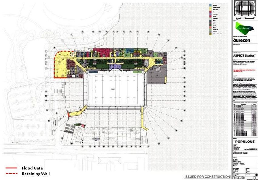
Figure 1. Location of the site

4                                VenuesLive
Figure 2. Level L00 – Pitch and Services

Bankwest Stadium - Flood Emergency Response Plan   5
Figure 3. Level L01 - Concourse

6                                     VenuesLive
Figure 4. North and East elevation

Bankwest Stadium - Flood Emergency Response Plan   7
Figure 5. South and West elevation

8                                    VenuesLive
Figure 6. Location of the 14m AHD topographic contour line with respect to level L00.

  Bankwest Stadium - Flood Emergency Response Plan                                      9
2      FLOOD BEHAVIOUR                            consecutive years or even two in the same
                                                  year. This happened in several locations in
                                                  Queensland and Victoria in 2010 and 2011.

2.1    FLOOD GENERATING                           Another way of expressing flood probability is
       WEATHER                                    in terms of Annual Exceedance Probability
                                                  (AEP). A 100 year ARI flood has roughly a 1%
Coastal areas of eastern Australia mostly         AEP. That is, each and every year it has a 1%
receive flooding rains from so-called "east       chance of being reached or exceeded. This is
coast lows" that develop from time to time over   perhaps a more helpful way of thinking about
the adjacent Tasman Sea. These are intense        flood probabilities, as it encapsulates the
depressions off the coast and can produce         variability in the frequency with which similar
thunderstorm activity associated with troughs.    flood events represent over time. A flood with
                                                  a 1% AEP has about a 1 in 2 chance of being
Depressions can develop at any time of year,      reached or exceeded in the average person’s
but are most likely when sea surface              life time, the same probability of tossing a coin
temperatures are high and the air is humid.       and getting a head.
Therefore, these events usually occur in the
summer months and over the first half of the      Bigger floods can and do occur. There were
year.                                             several floods with greater than a 1% AEP
                                                  experienced in Eastern Australia in early 2011.
Flooding can also be a winter-spring              Some reached levels which have a 1 in 2,000
phenomenon, associated with unusually             (0.005%) AEP. A flood with a 1 in 500 (0.02%)
frequent or active extra-tropical depressions     AEP has about a 1 in 6 chance of being
and fronts. However some major events have        reached or exceeded in the average person’s
occurred in the summer half-year as systems       life time, the same as tossing a dice and
of tropical origin extend or move south.          getting a 6.
Flooding over inland areas is usually
associated with southward-moving tropical         The largest flood that can possibly occur is
systems, but in the cooler months, may occur      referred to as the Probably Maximum Flood
when well-developed cloud bands extend            (PMF). Although it has a very low probability
across the interior from the oceans north and     of occurring in any one year (1 in 1000,000 or
northwest of Australia.                           less), events approaching a PMF have been
                                                  recorded.
Rainfall patterns are also dependant on longer
term weather patterns. Flooding is more           Flooding may occur at any time of year and at
prevalent in a La Nina year when rainfall is      any time of day. The most recent major floods
significantly greater than the mean average       in Parramatta – 1986 and 1988 – peaked in
rainfall. Thunderstorms, which generally occur    the afternoon and at night however there is no
during the summer, can also result in localised   seasonality associated with flooding in Sydney
flooding which could impact specifically on the   and an event could occur at any time of day or
site.                                             night and on any day of the year.

2.2    FLOOD PROBABILITIES                        2.3    FLOODING OF THE SITE

Flood probability can be expressed in more        Flooding of the site is primarily caused by the
than one way. For example, a flood may be         Parramatta River overtopping its banks,
described as having a 1 in 100 year Average       however minor flooding can also be caused by
Recurrence Interval (ARI). This means that        rainwater running across the ground (overland
over many thousands of years, a flood of this     local flooding).
magnitude would occur on average once in          The flood information certificate provided by
100 years. This does not mean that a flood of     City of Parramatta Council (Figure 8 and
this size only occurs once every 100 years. It    Figure 9) shows that the site is flood affected
is possible to have floods of this size in        in the Probable Maximum Flood(PMF). The

10                                                                                        VenuesLive
site is not affected by floods as large as the the site can be obtained by interpolating the
1% AEP event. This means that the site might levels upstream (profile 1021, PMF level of
flood to some extent only as a result of events 13.8m AHD) and downstream of it (profile
with a probability smaller than 1% per year. 1935, PMF level of 13.12m AHD).
The above information was obtained from the Importantly, the flood extents showed in the
flood model currently in use at the City of map provided by Council would have been
Parramatta Council, which underpins the obtained using a topography surveyed when
Upper Parramatta River Catchment Flood the old stadium was in place, however the
Study, undertaken by Bewsher Consulting in construction of the new stadium will affect the
2003. The modelling uses a RAFTS-XP local topography as a result of cut and fill
hydrologic model and a MIKE-11 hydraulic operations.
model. From the early 1990s the model was
Figure 6 shows the expected position of the
progressively updated to account for significant
14m AHD contour line once the new stadium
changes in the catchment including completion
will be completed. Because the maximum PMF
of flood mitigation works. However the
level will be 13.8m (upstream of the site), it is
software underpinning the model has now
reasonable to expect that floodwaters would
become obsolete and a new, more accurate
not be able to go past the 14m AHD contour
model is being prepared by Council and the
line, meaning that the flood affectation of the
results are likely to be officially released in
site is likely to be smaller than what is shown
early 2020.
in the flood maps.
Flooding of the site is therefore likely to occur
2.3.1 Flood Extent and Levels in two ways. Initially, the river will overtop its
banks in the vicinity of O’Connell Street and
The flood information certificate provided by rise through the southern car park towards the
Council for the site does not include the exact site. Given that level L00 is at 9.12m AHD, the
flood levels for the 5% AEP, 1% AEP and PMF maximum PMF depth at the southern end of
on site, as it usually does for smaller size the site would be between about 4m. This
developments. Instead, the certificate makes would be sufficient to flood level L00 facilities
reference to the attached flood maps (Figure 8 and services, the pitch and all of the car
and Figure 9), where flood levels for the above parks.
listed events are extracted at multiple cross
sections of the Parramatta River, upstream However, at some point as the river is rising it
and downstream of the site. would break its banks north and/or west of the
site and flow around the site towards
The maps confirm that, according to the flood O’Connell Street where the topography is
model currently used by Council, the site does lower than the river level. For example, at the
not flood in the 1% AEP event, but is affected peak of a PMF, the river would be overflowing
in the PMF. upstream of the site and would flow east along
However, the southern car park, which is as the site’s northern access road towards
low 6.7m AHD, would be partly flooded in the O’Connell Street at a depth of 0.5m or more.
5% (1 in 20) AEP flood which reaches 7.02m Once it reaches O’Connell Street it would flow
AHD at cross section 1935 which is adjacent to south towards the river and join the flood
the car park. The highest part of the car park waters which have reached the L00 level from
is at 8.6m AHD and this is about 0.5m higher the river rising to the south.
than the peak of the 1% AEP flood at this
location (8.14m AHD).
The format of the flood certificate provided by
Council makes it difficult to obtain the exact
peak flood level at the site in a PMF, because
these vary along the river depending on the
location of the cross section. However, a
reasonable estimate of the PMF flood level at
Bankwest Stadium - Flood Emergency Response Plan 11Figure 8. Flood extents and levels adopted by the City of Parramatta Council 12 VenuesLive
Figure 9. Flood hazard adopted by the City of Parramatta Council

Bankwest Stadium - Flood Emergency Response Plan                    13
2.3.3 Flood Rate of Rise and
2.3.2 Frequency of Flooding                                          Duration

The information provided by Council does not                   Figure 10 shows the hydrograph of the PMF
allow to define exactly from which probability                 upstream of the Marsden Street weir extracted
event the site would start flooding, however                   from the Upper Parramatta Mike 11 flood
this would be significantly less frequent than                 model. The hydrograph shows the water level
the 1% AEP event. Although it is noted that                    at a point along the Parramatta river between
the southern car park can begin flooding in                    section 1733 and 1935 in Figure 8. The level at
events more frequent than the 5% AEP event.                    this point is about 0.2m higher than the gauge
                                                               readings at the Marsden Weir.
Importantly, the probability that a large flood
occurs when a major event is taking place at                   This hydrograph was used in this study as a
the site is extremely low, ranging from 0.034%                 reference as it represents the worst case
to 0.0000001%, depending on the event and                      scenario of rate of rise in proximity to the site.
the flood AEP (Table 1). For reference, the                    Even in events smaller than the PMF,
probability of an individual being in a fatal car              floodwaters could rise as fast as shown in this
crash in Australia in year 2016 was                            hydrograph. For reference, the peak levels of
0.005%.(BITRE, 2018), which is about 1,500                     the 5% AEP and 1% AEP flood are also
times higher than the probability of the site                  shown, as well as the levels of Level L00 and
experiencing a PMF during a 30,000 people                      Level 01 at the site.
sport event, and 36,500 times higher than this                 The chart shows that in a flood rising as fast as
happening during a 40,000 people concert.                      the PMF, floodwaters would reach Level L00
However, it is acknowledged that the number                    after about 2h 20min from the beginning of the
of people at risk in the stadium during any                    rainfall, and that level would be isolated for up
individual event is at least 10,000 greater than               to 5 hours.
the number of people in most car accidents.

Table 1. Annual probabilities of a large flood happening while an event is taking place within the site

                                  No. of events per        1% AEP                         PMF
                                  year
                                                           (the site is flood free)

30k patrons sport event           Up to 50                 0.034%                         0.0000034%

40k patrons concert               Up to 2                  0.001%                         0.0000001%

 Figure 10. PMF hydrograph near O’Connell Street showing peak levels of the 5% and 1% AEP (in black) and floor
            levels at the site (in red)
14                                                                                                        VenuesLive
3 FLOOD FORECASTS specific information on individual
severe thunderstorm locations;
AND WARNINGS
- Broad-based State-wide Warnings.
These are based on broad areas
Monitoring the weather forecasts and warnings such as the Bureau's weather
will be an integral step in managing the flood forecast districts, and are issued
risk of the site. This will be critical to being with up to 3 hours’ notice.
able to evacuate the site before flooding
A Flood Watch for the Parramatta River
commences.
area.
A Flood Watch is a “heads-up” that flood
producing rainfall is forecast and flooding
3.1 BUREAU OF may eventuate. These are usually issued
METEOROLOGY (BOM) one or two days in advance of the
expected flooding and about 25% of the
The Bureau of Meteorology (BoM) has a time flooding does not eventuate.
number of generalised warning products that In addition to the above listed warning
could provide an indication of an increased products, the BoM has forecast rainfall maps
flood threat: which can be used to estimate the amount of
Severe Weather Warnings. rain expected to fall over the next eight and
four days, as well as the next 24 hours. This
The Bureau of Meteorology (BoM) issues
information is available at the following
Severe Weather Warnings whenever
website:
severe weather is occurring in an area or
is expected to move into an area. The http://www.bom.gov.au/jsp/watl/rainfall/pme.jsp
warnings describe the area under threat The radar service on the BoM website also
and the expected hazards. Warnings are
shows current rainfall locations and intensities.
issued with varying lead-times, depending
on the weather situation, and range from The radar station to be used for the site would
just an hour or two to 24 hours or be the Sydney Terrey Hills Radar
sometimes more. The key subtype of (http://www.bom.gov.au/products/IDR714.loop.
Severe Weather Warning to be monitored shtml#skip).
for the site are warnings with reference to
flash flooding for the Sydney Metropolitan The Bureau of Meteorology also has rainfall
Area. These are issued directly to the and river gauges which show the amount of
media by the BoM when there is a high rainfall that has fallen in the previous 24 hour
probability of flash flooding as a result of period and stream gauges which indicate
intense rainfall. Severe Weather water heights. The closest river gauge is
Warnings may also include other located at the Marsden Weir. Live readings of
conditions such as damaging winds. New
the river level can be seen at this webpage:
South Wales weather warnings are
issued by the BoM and can be found at Plot version:
the following link:
www.bom.gov.au/nsw/warnings/ and http://www.bom.gov.au/fwo/IDN60233/IDN602
access the relevant warning; 33.567107.plt.shtml
Severe Thunderstorm Warnings. Tabulated version:
A severe thunderstorm may produce http://www.bom.gov.au/fwo/IDN60233/IDN602
intense rain and flash floods, hail, 33.567107.tbl.shtml
damaging winds, and even tornadoes.
The BoM provides two types of Severe In order to relate the gauge readings to the
Thunderstorm Warnings: hydrograph shown in Figure 10, an offset of
- Detailed Severe Thunderstorm 3.94m should be used to account for the fact
Warnings. These are issued for that the gauge zero is 3.74m AHD and that in
capital cities only with up to 60 floods there is a slope on the water surface
minutes of notice, and provide more from upstream of the O’Connell Street bridge
to the gauge at Marsden Weir of about 0.2m.
Bankwest Stadium - Flood Emergency Response Plan 15For instance, if the gauge reading is 0.5m, the called “Floodsmart” and can be accessed at
actual flood level will be: the following link:
Flood level AHD = gauge reading + 3.94m https://www.cityofparramatta.nsw.gov.au/recre
ation-environment/floodsmart-
=0.5m+3.94m= 4.44m AHD
parramatta/flood-warning-service
Floodsmart provides flood early warning
3.2 FLOODSMART messages via text, email, or automated voice
message. The system includes seven different
In addition to the information provided by the warning areas covering Parramatta LGA. The
BoM, the City of Parramatta Council has area relevant to the Bankwest stadium is
recently put in place a local flood warning “Westmead and North Parramatta”. The
system which is freely available to anyone types of flood warnings provided are
subscribing to the service. The system is summarised in Table 2.
Table 2. Flood smart warning system: types of warning messages
Type of Warning Message Description
Risk to life from fast flowing or deep water near the river or
MINOR: creek
High risk areas may Closure of roads most at risk of flooding
experience property Flooding of land near rivers, creeks, low spots and recreational
flooding areas
Water levels may be high for many hours
High risk to life from fast-flowing or deep water near the river or
MODERATE: creek
High and Medium risk areas Closure of many bridges and roads
may experience property Widespread flooding in areas not necessarily near the river
flooding.
Water levels may be high for many hours
Damage is possible to buildings and infrastructure
MAJOR: Extreme risk to life from fast-lowing deep water even in areas
High, Medium and Low risk not near the river or creek
areas may experience Closure of many bridges, roads and transport routes
property flooding
Widespread deep flooding in many areas not necessarily near
the river
Water levels may be high for many hours
The local conditions should now be improving:
NO FURTHER No further flooding is expected in the next 12 hours
IMPACT
Flood levels will continue to drop
However:
There may still be dangerous fast flowing water near the river or
creek
Debris and contamination may still cause problems in areas that
have been flooded
16 VenuesLiveAccording to Council’s classification of flood warnings can be issued with a maximum
warning areas (Figure 11), the stadium is notice of up to 2 hours, however in rapidly
classified as a development at LOW RISK of evolving circumstances the warning notice
flooding. As such, it is at risk of flooding only may be shorter.
during a MAJOR flood. However the southern
car park is classified as being at MEDIUM
RISK and it may experience flooding in a
MODERATE flood (Table 3). Floodsmart
Table 3. Flood warning types relevant to different items within the site as per the Floodsmart system
Element at risk Flood Warning Area Relevant Flood Warnings
Classification
Stadium, including northern and LOW RISK MAJOR,
western car parks and access
NO FURTHER IMPACT
driveway
Southern car park MEDIUM RISK MODERATE, MAJOR,
NO FURTHER IMPACT
Figure 11. Flood warning areas as defined in the Floodsmart war system
Bankwest Stadium - Flood Emergency Response Plan 173.3 OBSERVED FLOOD
LEVELS
While the BoM and Council have several
products which can provide some advanced
warning of potential or actual flooding or
provide real time data on actual rainfall
intensities and river levels, this data may not
be accessible during a flood. This may be
because the severe storms or flooding damage
the gauges or they damage the
telecommunications or electricity infrastructure
needed to transmit data and disseminate
warnings, or there may be human error in
interpreting data and issuing warnings.
It will therefore also be important to visually
monitor water levels in the river. This would
most easily be done from the southern end of
the concourse level looking over the southern
car park.
18 VenuesLive4 EMERGENCY 4.1 EVACUATION MODELLING
PREPAREDNESS AND
RESPONSE 4.1.1 Scope
CONSIDERATIONS An assessment of the evacuation time in the
largest possible site event was undertaken to
The two main types of responses to a flood understand if:
emergency are to either: Evacuation would be possible at all
before evacuation routes are cut by
Evacuate to an area above the reach of
floodwaters in a PMF;
floodwaters. This is the NSW SES
preferred response, provided that the At what point in time an evacuation order
risks of evacuating are deemed would need to be issued to provide
acceptable; enough notice for all patrons and staff to
leave the site before evacuation routes
Take Shelter in Place (SIP) (i.e. within the
are cut; and
Stadium) and wait until floodwaters have
receded and the emergency has passed. How often, on average, floodwaters
SIP is to be considered an alternative to would reach the level selected as a
evacuation only when the risks of trigger for evacuation. It should be noted
evacuating are higher than the risks of that even if the evacuation trigger level is
SIP. reached and an evacuation order is
issued, in most instances floodwaters
Both evacuation and SIP were considered as
would stop rising before affecting the site
possible flood emergency response strategies or cutting evacuation routes. However in
in this FERP. This Section provides a extremely rare circumstances floodwaters
summary of the flood emergency response would keep rising to the peak of the PMF
analysis (for evacuation and SIP) that was and would isolate the site. During a real
undertaken as part of this FERP to inform the event it will not be possible to know with
identification of the most suitable response sufficient notice when floodwaters will
strategy and management actions. stop rising after the evacuation trigger
level is reached. It was therefore deemed
The analysis was undertaken using a worst desirable that the evacuation trigger level
possible scenario approach. Namely, it was is not reached too often (ideally less often
assumed that the worst possible flood (i.e. the the once every 20 years).
Probable Maximum Flood, or PMF) would Because in each large event several hundred
occur during the largest possible event that will patrons would reach the site by car,
be held at the Stadium (i.e. a 40,000 patron evacuation was modelled as a combination of
concert). However it should be emphasized pedestrian and vehicular evacuation.
that flood emergencies are more likely to occur
during normal operating hours (Monday to
Friday, 7AM to 7 PM), when only up to 50 staff 4.1.2 Assumptions
will be onsite, or during the night, when only
security will be on site. Furthermore, most The following assumptions were used:
flood emergencies will be much smaller events The event would host 40,000 patrons, of
than the PMF. which 15,000 would be in the pitch and
25,000 in the seating areas;
However, by having a FERP which can cater
for the largest event in the largest flood, all Management would take about 10
floods can be appropriately responded to at minutes to decide to evacuate and
any time. disseminate an evacuation order after
they become aware that the trigger level
has been reached;
To avoid traffic delays due to pedestrians
blocking access to the road to vehicles
and vice versa, pedestrian evacuation
Bankwest Stadium - Flood Emergency Response Plan 19would begin only when vehicular 2005), pedestrians would be able to move
evacuation has completed. at a speed of at least 700 metres per
hour, with a density of up to two people
Patrons would decide to evacuate per square metre through the concourse
immediately after an evacuation order is and in areas external to the stadium.
issued;
Further assumptions regarding vehicular
In line with the assumption of the Stadium
Emergency Management and Response evacuation only:
Plan, it would take up to 8 minutes for People evacuating by car would exit the
anyone in the stadium’s seating area to stadium using the closest exit to the
reach the Concourse level from the relevant car park and would take about
moment they decided to evacuate after 10 minutes to reach their cars after
an evacuation order has been issued. leaving their seats, as they would need to
Once on the concourse there would be no walk a maximum distance of 500m;
further bottlenecks within the stadium to
slow down the flow of evacuees (i.e. free All car parking spots would be occupied
flow); in any event. These equate to the
following number of cars:
Patrons on the pitch would be able to
evacuate by either walking up to the - Northern car park - 292
Concourse level (L01) using the aisles in
between seats (20 aisles would be - Western car park -187
available to do so), or walking through the
- Southern car park- 348
north-east and north-west tunnels at the
relevant corners of the pitch. Because the - Total – 827
south-east and south-west tunnels
terminate at level L00 (i.e. 9.12m AHD), In line with the assumptions of the NSW
these will be cut earlier that all the other SES Timeline Evacuation Model (Opper
exits and as such it was assumed that et al, 2009), vehicular evacuation would
these tunnels will be closed during an proceed at a speed of 600 cars per lane
evacuation. This means that patrons in per hour;
the pitch would take an extra couple of All cars in the southern car park would
minutes to reach the Concourse level or leave the site from the south driveway
to exit the stadium though the north-east and move north along O’Connell St or
tunnel in addition to the 8 minutes east along Victoria Rd, then north on
mentioned above. Villiers St;
Further assumptions applying to pedestrian All cars parked in the western and
evacuation only: northern car parks (total of 479 cars)
Pedestrians would exit the site either from would leave the site from the northern
the north-east gate at the Concourse driveway and move north on O’Connell
level or from the north-east tunnel as Street up to Grose St, then continue in
these exit points are the closest to a flood O’Connell St and Grose St;
free area in the PMF. Pedestrians would Each driveway would have two lanes
then continue walking north along available to exit the car park during a
O’Connell St up to the crossroad with flood emergency.
Ross St, where some of them would
continue on Ross St (Figure 12);
The bottleneck along the pedestrian
evacuation route would be in O’Connell
St, immediately north of the stadium’s
north-east gate. About 40,000 people
would need to walk past this point in an
evacuation. The road width here is 22m
(footpaths plus road), but it was
conservatively assumed that only 20m
would be available for evacuation;
In line with the relevant literature on
pedestrian evacuation (Seyfried et al.,
20 VenuesLiveFigure 12. Pedestrian Evacuation Route
min for patrons to walk to the Concourse
level and 10 additional min to walk to the
car, would be 45min.
4.1.3 Evacuation Time Needed The 479 cars in the northern and western
car parks would take 24 minutes to clear.
Under the assumptions listed in previous The total evacuation time for this car
section, the following evacuation times were park, including 10 min for Management to
obtained. decide to issue the evacuation order, 8
min for patrons to walk to the Concourse
level and 10 additional min to walk to the
a) Pedestrians
car, would be 52min.
It would take 1h 25m for 40,000
pedestrians to walk past the bottleneck in
O’Connell Street and reach a flood-free 4.1.4 Evacuation Timeline
area;
An evacuation timeline is usually defined by:
The total pedestrian evacuation time,
including 10 min for Management to Identifying the hydrograph of the worst
decide to issue the evacuation order and possible flood event (the PMF) at a
8-10 min for patrons to walk to the known location nearby the site. This is
Concourse level, would be 1h 45 min. shown in Figure 10 and Figure 13.
Identifying the level of the lowest point
b) Cars along the evacuation route;
The 349 cars in the southern car park Using the hydrographs, identifying the
would take 17 minutes to clear. The total time at which the lowest point is cut by
evacuation time for this car park, floodwaters;
including 10 min for Management to
decide to issue the evacuation order, 8
Bankwest Stadium - Flood Emergency Response Plan 21 Subtracting the total evacuation time from southern car park would end up flooding (if at
the time at which the evacuation route is all).
cut to identify the time at which
evacuation should begin; As such, it was decided to evacuate the site in
three stages, each one having its own trigger:
Identifying the level of floodwaters at the
time evacuation should begin to set the 1. A first evacuation order would be
evacuation trigger. triggered only for patrons who have
In this case, given the large size of the site and parked their cars in the southern car
the fact that the local topography ranges park, which is the first to flood;
between 6.7m AHD and 15m AHD, two 2. If floodwaters continue to rise, a
evacuation routes were identified (one second evacuation order would be
vehicular only for cars in the southern car park, triggered only for patrons who have
the other one both pedestrian and vehicular, parked their cars in the western and
for cars in the western and northern car parks northern car park;
and for all patrons on foot).
3. Once vehicular evacuation is
The lowest point of each route is at very completed, if floodwaters have
different levels and they are each impacted by continued to rise, pedestrian
flooding rising in the river at different locations. evacuation would be triggered.
The lowest point along the evacuation route Alternatively, pedestrians could remain
from the southern car park is within the car within the stadium (SIP) until
park itself, at its south-east corner, at a level of floodwaters have receded.
6.7m AHD. This is flooded from water rising in A timeline of the above described evacuation
the river at O’Connell Street at the location process was generated and associated to the
where the hydrograph in Figure 13 has been hydrograph of the PMF near O’Connell Street
extracted from the model. These river levels (Figure 10). This was achieved using the total
are about 0.2m higher than the corresponding evacuation times calculated in Section 4.2.3 to
levels at the Marsden Weir about 200m work backwards from the moment when
downstream. evacuation routes are cut and identify the
The lowest point along the evacuation route relevant evacuation trigger levels and times.
from the western and northern car parks, as The resulting evacuation timeline is shown in
well as along the pedestrian evacuation route, Figure 13.
is near the junction between the northern
driveway and O’Connell Street, at a level of
13.25m AHD. This is first affected by flooding 4.2 CONSULTATION
from water breaking out of the river north of the
stadium about 1km upstream of O’Connell The evacuation modelling results, assumptions
Street. Water levels at this point are about and timeline described in Section 4.2 were
0.5m higher than at O’Connell Street in large presented and discussed in a face to face
floods. meeting with:
The significant difference in ground levels A representative from the NSW SES;
between these two low points and the river
The Local Emergency Management
levels which affect them means that the two
Officer, who is the liaison officer for all
evacuation routes would be cut at very hazards in Parramatta LGA, including
different times during a flood. Namely, the floods and fires ;
southern car park will flood much earlier and
A representative from Council’s
more frequently than the northern driveway.
Development Applications Office;
In these circumstances, having a single
VenuesLive’s General Manager;
evacuation trigger for the whole site would be
highly impractical, because in most flood Molino Stewart’s flood engineers.
events that trigger an evacuation only the
22 VenuesLiveFigure 13. Evacuation timeline and trigger levels plotted on the PMF hydrograph near O’Connell Street
During the meeting the challenges of park would likely cause concern, if not panic,
evacuation and shelter in place for the site among all the other patrons.
were identified. A series of measures to
Finally, patrons who have their cars in the
address these challenges were also proposed,
southern car park would need to walk from a
discussed and approved. These are
lower risk zone (i.e. the stadium) to a higher
summarised in the following sub-sections.
risk zone (i.e. the car park). Any unforeseen
delays in the evacuation could result in patrons
4.2.1 Evacuation Challenges reaching the car park when this is already
flooding.
The following challenges of the proposed To address these challenges, the NSW SES
evacuation strategy and timeline were proposed to close access to the southern car
identified: park before the event, if the available flood
forecasts suggest that a flood large enough to
a) Evacuation of Southern Car Park affect the car park may occur within a few
hours. This suggestion was implemented in
Even though the proposed staged evacuation
this FERP by creating a series of Alert Modes
strategy would avoid unnecessary and
and triggers (refer to Section 5.1).
frequent evacuations of all patrons on site,
evacuation of the southern car park would still
be triggered very often. In fact, the trigger level b) Flooding of Level L00 from Southern
at the Marsden Weir gauge would be 4.3m Gates
AHD, and the average level at this gauge is In a flood rising as fast as the PMF,
about 4.2m AHD, meaning that a small floodwaters would start entering Level L00
fluctuation in level would trigger evacuation of about 20-30 minutes after the pedestrian
the car park. evacuation order is issued. At that point in time
Moreover, issuing an evacuation order only for all patrons at level L00 should have already
patrons who have their cars in the southern car evacuated, but any delays may result in
patrons becoming in contact with floodwaters.
23 VenuesLiveIn addition to this, Level L00 contains a large d) Where to Evacuate?
part of the infrastructure and facilities that will Even if all pedestrians evacuated north using
need to be fully operative during a flood the designated evacuation route, there would
emergency (e.g. power generator and fuel be no suitable facilities within walking distance
tank, electric power main switches, fire pump, to receive such a large number of people.
security rooms). Evacuees would most likely have to wait in the
These issues will be addressed by water streets until floodwaters withdraw, under
proofing the two southern access points to intense rain and without any of the services
level L00 with two 2.4 m high automatic flood that the stadium would have otherwise
gates. The western gate will also require a provided (e.g. shelter, sustenance, access to
retaining wall along the road connecting the toilets, access to information, access to
southern driveway to the western car park medical aid). This may expose evacuees to
(Figure 14). The retaining wall will have the risks that could be deemed higher than the
same height as the flood gate (i.e. 2.4m AHD). risks associated with taking shelter within the
The gates and retaining wall will be coupled stadium.
with a series of automated backflow blocking This issue was discussed during the
devices to be placed along all drainage pipes consultation meeting and it was agreed that
connecting the stadium to the river. This the most appropriate solution would be to offer
system will protect level L00 up to a level of patrons the choice to either evacuate or shelter
11.52m AHD. Based on the flood levels in place. This will be done by providing suitable
provided by Council, it was estimated that this information to patrons regarding the
level corresponds approximately to a 1 in implications of evacuating or taking shelter in
50,000 year average recurrence interval (ARI) place. This information will be provided via
flood (Figure 15). emergency messages issued via the PA
system.
c) Risk of Pedestrians Evacuating South
As discussed in Section 4.2, once they have 4.2.2 SIP Challenges
left the site all evacuees would have to head
north on O’Connell Street, because there is a If patrons made the decision to take shelter
risk that at that point O’Connell Street will within the stadium until the emergency has
already be cut by floodwaters in proximity to passed, in the worst possible scenario they
the river, or that most roads in the CBD will be would be isolated by floodwaters for about 2h
cut by local flooding. However patrons who will 40min (Figure 13). In addition to the relatively
reach the site on foot will likely arrive at short isolation time, the maximum water depth
Parramatta by train or bus, and both the train along the evacuation route would be around
station and the bus interchange are located 0.5m. While it is widely acknowledged that
south of the river. Other patrons may decide to there are risks associated with taking shelter in
drive and park their cars in one of the covered place, these are generally greater for longer
secure car parks in the CBD. These patrons, isolation times. Nevertheless, the risks of SIP
when asked to evacuate, would naturally go were identified and addressed as part of this
home in the same way they arrived to FERP. These include:
Parramatta, and would therefore try and walk
south on O’Connell Street and cross the river.
This risk will be addressed by ensuring that
when pedestrian evacuation commences,
there is a sufficient number of staff in
O’Connell Street advising evacuees to walk
north.
24 VenuesLiveFigure 14. Position of flood gates and retaining wall to water proof the southern access points to level L00 Bankwest Stadium - Flood Emergency Response Plan 25
14
Peak Flood Level Parramatta River Upstream of
12 11.52m
10
O'Connel St (mAHD)
8
6
4
2
0
1 10 100 1000 10000 100000 1000000
Flood ARI 50,000
Figure 15.Estimated relationship between peak flood levels and Average Recurrence Interval of flood events
upstream of O’Connell Street.
Providing access to food and water. The
a) Patrons Walking through Floodwaters stadium will host several food and
Some patrons might become impatient while beverage retailers. It is expected that the
normal stock of food and beverage will be
the site is isolated and walk though
sufficient to cover any sustenance needs
floodwaters. This is a known risk for any SIP- for an isolation time of less than 3h.
based response strategy and can exacerbated Furthermore, the stadium management
by circumstances in which there is a lack of will have authority to distribute food and
power, sustenance, access to medical care, or beverage free of charge, should this
overall comfort or inability to access become necessary. A decision to do so
information of the expected duration of will be made based on an assessment of
isolation. isolation time and overall condition of
patrons.
These risks will be reduced by:
Providing shelter from the rain and
Reducing the probability of power failure access to toilets. The stadium roof was
to acceptable levels. The stadium will be designed to provide satisfactory
equipped with two independent power protection against weather and rain to
substations. If both substations ceased to patrons in the seating area. During
function, an emergency power generator concerts however, patrons in the pitch
located al level L00 would automatically would be exposed to the rain and may try
turn on. Furthermore, Level L00 will be to climb up in the seating area to seek
protected from flooding with flood gates shelter. This may result in a higher
and retaining walls as described in density of patrons in the seating area,
previous section up to flood events as which could eventually lead to public
rare as the 1 in 50,000 ARI order issues. This risk will be reduced by
(corresponding to a 0.002% AEP on any (a) providing patrons a chance to
day or about a 0.00004% AEP during an evacuate, which will create additional
event). room in the covered seating area, and (b)
26 VenuesLiveif required in concert events the seating reduced thanks to the stadium automated fire
area behind the stage could be opened to suppression system.
accommodate patrons who decided to
shelter in place. In addition to the above, the stadium will
feature the following emergency management
Providing updates on the expected flood
equipment:
duration based on communications with
the NSW SES. Updates will be provided Public Announcement (PA) system. The
using the video screens and PA system PA system features sufficient speakers to
and the Emergency Warning Intercom reach each part of the playing field and
System (EWIS), a fire safety system seating area. The PA system control
controlled from the Fire Panel with room will be located well above the reach
speakers all around the venue. of floodwaters at level L04.
The Emergency Warning Intercom
b) Patrons Requiring Medical Attention System (EWIS), a fire safety system
controlled from the Fire Panel with
A medical team will be on site with sufficient
speakers covering every part of the
staff and equipment to deal with the risk profile venue. This will be used for official
of each event, as defined in the stadium emergency communications such as
Emergency Management and Response Plan. evacuation messages. EWIS will have a
The medical services provider will have a larger reach than the PA system, which
number of staff on site and be supported by St was designed for entertainment purposes
Johns Ambulance for every event. and will cover only the pitch and seating
areas.
c) Risk of Fires Video screen. A large screen will be
installed on top of the seating area and
A secondary risk generally associated with SIP will be visible from the pitch and all seats.
is the risk of fire. This risk is exacerbated when The screen main purpose will be to
the isolation time is long and there is lack of provide information related to the event
power in residential dwellings where people being held, but if needed will be used for
may improvise cooking, heat and lighting using emergency purposes. For instance, flood
emergency messages will be displayed
naked flames. food, light or heat, pushing
on the screen.
people to light With an isolation time of less
than 3 hours, a non-residential setting and A CCTV camera system. The system will
emergency power supplies it is extremely cover all parts of the site including the car
parks. Live videos will be transmitted to
unlikely that the risk of fire at the venue would
the control room at level L04 and will be
be increased during a flood. Nonetheless, the monitored by the Chief Warden (or
risk of fire will be managed according to the delegates).
stadium Fire Emergency Plan, and will be
Bankwest Stadium - Flood Emergency Response Plan 275 FLOOD EMERGENCY Red: flooding of the site in the next two
hours is possible
RESPONSE PLAN Black: flooding of the site is possible
within the next hour
This section outlines the basic principles Green: all clear, floodwaters have
underlying flood emergency response (Section withdrawn and there is flood-fee access
5.1), roles and responsibilities (Section 5.2), to or from the premises
communication methods (Section 5.3) and the These may be revised up or down depending
list of response actions and triggers (Section on the changing forecasts and actual
5.4). conditions. Once a decision is made to cancel
an event this cannot be revised.
An Alert Mode Table has been developed
5.1 EMERGENCY RESPONSE
which nominates thresholds that trigger
PHILOSOPHY escalation of alert modes.
It is recommended that the Alert Table plays a
5.1.1 Priorities key role in the planning and training processes
before a flood occurs, as well as when flooding
This FERP recognises that protection of life is is possible and when it does happen. It will be
of critical and primary importance. This FERP important to maintain the Alert Table and
is principally concerned with the safety and update this if new information is made
comfort of patrons and staff. All flood available and review it after events which
emergency responses recommended in this trigger any level of flood response.
FERP are to recognise the primacy of life and
The Alert Mode Table is shown in Table 4 and
wellbeing over property.
will be used to define the trigger points for
Nonetheless, it is recommended that the undertaking actions when flooding is occurring
Stadium Management and staff take all or could possibly occur.
necessary measures outside of this FERP to
manage the risks which flooding poses to the It should be stressed that the Alert Mode
MUST be escalated if any one of these
site.
thresholds alone is reached or exceeded
The FERP sets emergency management because there is a high degree of certainty that
prevention, preparedness and response the corresponding management actions will be
measures that are relevant to a flood necessary.
emergency. Broader emergency management
guidance for any type of hazards that could
affect the Stadium are defined in the Stadium
the Emergency Management and Response
Plan under which this FERP sits.
5.1.2 Alert Modes
To assist in managing flood risks and
communicating response actions, five flood
alert modes have been developed for use in
this FERP. They have been colour coded to
further assist in communication. They are:
White: normal operations
Yellow: flooding of the site in the next 24
hours may be possible
Orange: flooding of the southern car park
in the next two hours is possible
28 VenuesLiveTable 4. Alert Mode Table setting triggers for each Alert Mode. A single trigger is necessary and sufficient to activate the relevant Alert Mode.
WHITE YELLOW ORANGE RED BLACK GREEN
Normal Operations Flooding of the site Flooding of the Flooding of the site Flooding of the site All clear after flood
possible within the southern car park is is possible within is possible within event
next 24 hours possible within the the next 2 hours the next hour
next 2 hours
BoM Severe Weather Not Applicable A Severe Weather Not Applicable Not Applicable Not Applicable Not Applicable
Warning for the Warning is issued
Parramatta Area
OR ↴
BoM Flood Watch Not Applicable A Flood Watch is Not Applicable Not Applicable Not Applicable Not Applicable
issued for issued for the
Parramatta River Parramatta River
OR↴
City of Parramatta Not Applicable A MINOR flood A MODERATE flood A MAJOR flood Not Applicable A NO FURTHER
Floodsmart warning warning is issued warning is issued warning is issued IMPACT warning is
system issued
OR↴ OR↴
Marsden Weir live Not Applicable Not Applicable Marsden Weir gauge Marsden Weir gauge Marsden Weir gauge Not Applicable
gauge reading reading = 0.56m reading = 3.06m reading = 4.16m
AND AND OR↴ OR↴
BoM forecast rainfall 24h forecast rainfall is
50mm or greater
OR↴
Visual Observation Not Applicable Not Applicable Floodwaters are Floodwaters are Floodwaters are Not Applicable
sighted in the green sighted entering the sighted half way
area between the southern car park through the southern
southern car park, the car park
river and O’Connell OR↴
Street OR↴
OR↴
Direct Not Applicable Not Applicable Received advice that Received notification Received evacuation The SES gives the all
communication from the southern car park that a MAJOR flood is order clear
NSW SES may flood. expected
29 VenuesLiveYou can also read