Automated Extraction of Labels from Large-Scale Historical Maps
←
→
Page content transcription
If your browser does not render page correctly, please read the page content below
AGILE: GIScience Series, 2, 12, 2021. https://doi.org/10.5194/agile-giss-2-12-2021
Proceedings of the 24th AGILE Conference on Geographic Information Science, 2021.
Editors: Panagiotis Partsinevelos, Phaedon Kyriakidis, and Marinos Kavouras.
This contribution underwent peer review based on a full paper submission.
© Author(s) 2021. This work is distributed under the Creative Commons Attribution 4.0 License.

Automated Extraction of Labels from Large-Scale Historical
Maps
Inga Schlegela (corresponding author)
inga.schlegel@hcu-hamburg.de
a
    Lab for Geoinformatics and Geovisualization (g2lab), HafenCity University Hamburg, Hamburg, Germany

                                                                                  and often complex maps is an ongoing challenge
Abstract. Historical maps are frequently neither
                                                                                  (Nazari et al., 2016).
readable, searchable nor analyzable by machines due to
lacking databases or ancillary information about their                            The purpose of this study is to demonstrate a universal
content. Identifying and annotating map labels is seen                            solution for an automated detection and recognition of
as a first step towards an automated legibility of those.                         text elements from large-scale (≥1:10,000, Kohlstock
This article investigates a universal and transferable                            (2004)) historical maps without the need of making
methodology for the work with large-scale historical                              major individual adjustments for individual maps. With
maps and their comparability to others while reducing                             this goal in mind, we have been able to locate and label
manual intervention to a minimum. We present an end-                              geographical features which, in general, are not
to-end approach which increases the number of true                                accessible from historical maps. Besides, a contribution
positive identified labels by combining available text                            to an approximate georeferencing of historical maps
detection, recognition, and similarity measuring tools                            has been made.
with own enhancements. The comparison of
                                                                                  We present an automated workflow for detecting and
recognized historical with current street names
                                                                                  recognizing labels from historical maps and comparing
produces a satisfactory accordance which can be used
                                                                                  them with current street names. This matching enables
to assign their point-like representatives within a final
                                                                                  a spatial referencing of further streets and places so that
rough georeferencing. The demonstrated workflow
                                                                                  an initial spatial orientation within a historical map is
facilitates a spatial orientation within large-scale
                                                                                  possible. The gained information may be useful for
historical maps by enabling the establishment of
                                                                                  subsequent database productions or comparisons
relating databases. Assigning the identified labels to
                                                                                  between different maps, e.g. from various periods.
the geometries of related map features may contribute
to machine-readable and analyzable historical maps.                               This paper is structured as follows. In Sect. 2, an
                                                                                  overview of current challenges and related work
Keywords: historical maps, text detection, text
                                                                                  concerning text extraction from historical maps is
recognition, text extraction, optical character
                                                                                  presented. Section 3 illustrates details on our used data
recognition, levenshtein distance, georeferencing
                                                                                  and methodology before experimental results of
                                                                                  individual stages (detection, recognition, and
                                                                                  comparison of map labels) of our end-to-end approach
1 Introduction
                                                                                  are reported in Sect. 4. Finally, Sect. 5 concludes the
Automatically extracting labels from historical maps is                           paper by discussing further potential enhancements and
not as straightforward as it is the case for current maps                         future work.
(Chiang, 2017; Lin and Chiang, 2018). A frequent lack
of in-depth information, which is generally
implemented by databases within current maps, impairs                             2 Current challenges and state of research
a simple search or analysis of places, street or building
                                                                                  Compared to current digital maps, a simple scan of a
names, and other local designations within historical
                                                                                  historical map represents no more than an ordinary
maps. As a large part of existing attempts are restricted
                                                                                  bitmap image consisting of a number of pixels, each
to e.g. a particular cartographic style and therefore not
                                                                                  holding a color value. It can be seen as a hybrid of
transferable to others, detecting text in these scanned
                                                                                  similar color regions, textures, and strokes (Ye and
                                                                                  Doermann, 2015). An automated distinction between

                          Reproducibility review: https://doi.org/10.17605/osf.io/anv9r                                               1 of 14
text and other map elements such as geometries of                       map features apart from specific line types (Tombre
buildings or roads is considered as major challenge.                    et al., 2002).
For monochrome historical maps, this differentiation                    An increasing number of studies are based on the early
cannot solely be based on on color information                          involvement of a gazetteer or a comparable database
(Iosifescu et al., 2016). The great stylistic variety                   available from other sources to match place names with
among historical maps and their individual typefaces                    those extracted by small-scale maps (Milleville et al.,
raise a claim for further differentiators when applying                 2020; Simon et al., 2014; Weinman, 2013). However,
automated approaches such as machine learning.                          this so-called geoparsing only works with a
Recurring patterns and shapes, which are utilized e.g.                  comprehensive gazetteer and for place names which do
in the course of automated face detection or the                        not shift over time. These rarely exist for historical
identification of roads for autonomous driving, can                     large-scale maps.
rarely be found within old maps and their labelling
                                                                        To properly address the mentioned issues, Laumer
(Nazari et al., 2016). Other, technically induced
                                                                        et al. (2020) assigned each pixel either to a map’s
drawbacks turning the described issue into a complex
                                                                        foreground (resp. labels) or background with the help
task are a low graphical quality or perspective
                                                                        of convolutional neural networks. Within their
distortions which are caused by scanning processes, for
                                                                        approach, labels, or rather clusters built up from
instance.
                                                                        interrelated characters, were interpreted, manually
The mentioned aspects often cause unsatisfactory                        matched, and corrected by the combined use of
results when applying (semi-)automated text detection                   Google’s Vision API and a local gazetteer. Machine
and recognition to historical maps. Manual post-                        learning approaches may enable a universal solution to
processing becomes necessary as soon as parts of map                    automatically detect and extract text from a variety of
labels have not been identified or a context to similar                 maps. Although their application requires a large
words is missing (Chiang et al., 2020; Chiang and                       amount of input training data it offers the advantage to
Knoblock, 2014).                                                        process data without any manual intervention (Chiang
                                                                        et al., 2020). With Strabo, Chiang and Knoblock
Both automated and semi-automated processes aiming
                                                                        (2014) provide a command line tool for detecting text
at the identification of text in historical maps imply a
                                                                        within maps which is not only based on color
series of advantages and drawbacks. With semi-
                                                                        differences but also on other characteristics such as the
automated methods a higher recognition rate of a
                                                                        similarity of text sizes or distance measures between
greater variety of map content can be achieved,
                                                                        individual characters. Its application may be promising
whereas, at the same time, laborious manual processing
                                                                        when examining monochrome maps.
is essential. Hence, only a small quantity of maps can
be processed by such time-consuming approaches.                         Until now, machine learning has not been widely used
Previous research also showed limitations to highly                     to analyze historical maps. Instead, binarized connected
specific map types or typefaces (e.g. straight aligned                  components or other bottom-up approaches have been
and horizontal labels or uniform text sizes) do exist                   applied onto maps to detect labels (Weinman et al.,
(Chiang and Knoblock, 2014). A number of authors                        2019). So far lacking in the scientific literature, this
have suggested the utilization of a Hough transform to                  paper addresses an appropriate combination of
extract text from images or maps but have not not                       automated text detection and recognition from
considered curved labels (Fletcher and Kasturi, 1988;                   historical large-scale maps with the aim of extracting
Velázquez and Levachkine, 2004) or even alphabetic                      machine-readable information.
characters (Chen and Wang, 1997). Methods employed
by Goto and Aso (1999) and Pouderoux et al. (2007)
which identify text in maps based on the geometry of                    3 Materials and methods
individual connected components do not consider
characters of various sizes. Cao and Tan (2002) made                    3.1 Data
use of individual thresholds to detach the black map
                                                                        For demonstrating our suggested approach with an
layer consisting of text and contours as well as of
                                                                        illustrative example, we chose a large-scale historical
connected components to differentiate between those.
                                                                        map of the city of Hamburg from 1841 (exemplary
Although this is considered a much faster approach
                                                                        extract in Fig. 1). Map features such as buildings, built-
compared to a Hough transform, their tailor-made size
                                                                        up areas, roads, railroads, stations, drainage, and docks
filters cannot handle overlaps between text and other

AGILE: GIScience Series, 2, 12, 2021 | https://doi.org/10.5194/agile-giss-2-12-2021                                        2 of 14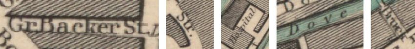
are illustrated (Hamburg, Germany 1853). Due to the                     with other map elements (Chiang and Knoblock, 2014;
map’s salient color composition and texture the human                   Tombre et al., 2002). Also, blurred, reflective, or
perception of map objects and their differentiation is                  partially obscured input images can be processed up to
facilitated (Schlegel, 2019). The dark labels, primarily                a certain point (Rosebrock, 2018a). The open source
designating streets, squares, and water bodies are                      tool implements functions of available Python libraries
clearly visible on the bright background but frequently                 (e.g. NumPy, OpenCV, SciPy, TensorFlow, Matplotlib)
connected to or even overlapping textured objects.                      for vector and image processing, statistical
                                                                        computation, machine learning, and visualization. It
According to general recommendations, a high
                                                                        separates a text layer from the rest of an input image
resolution (≥300 dpi) of the scanned input map is ideal
                                                                        based on differences in color, text size ratios, and
so that characters are large enough to be readable by
                                                                        appropriate text samples (Chiang and Knoblock, 2014).
automatic text recognition tools (Milleville et al.,
                                                                        As an output, Strabo supplies a vector dataset including
2020). With regard to a reduction of computational cost
                                                                        rectangular bounding boxes each holding an (raster)
and time, an appropriate map subset illustrating as
                                                                        input image area where text was detected (see upper
many differing map features as possible was chosen for
                                                                        third of Fig. A1 in Appendix).
further procedure. The input image, as seen in Fig. 1,
was stored in lossless PNG format.
                                                                        3.3 Additional adjustments

                                                                        As is the case with many applications, Strabo regularly
                                                                        detects only parts of map labels or even omits them
                                                                        entirely. Further manual post-processing is necessary
                                                                        for these results (Chiang et al., 2020). While avoiding
                                                                        an individual editing for each map – whether via pre-
                                                                        or post-processing – we focus on a universal solution to
                                                                        this issue. Regardless of a map’s apparent condition,
                                                                        year of creation, style, or color composition a
                                                                        transferability to other similar large-scale maps is
                                                                        desirable.
                                                                        When working with Strabo we could determine the
                                                                        following points which might have prevented an
                                                                        adequate detection of labels:
Figure 1: Subset of Hamburg, drawn under the direction of
Willm. Lindley, Esqr. C.E. April 1841; engraved by B.R.                      •    Specific label orientation due to the lack of
Davies used as exemplary dataset (Hamburg, Germany,                               corresponding training data (Chiang, 2019).
1853).                                                                            As suggested by Tesseract’s (see also
                                                                                  Sect. 3.4) user documentation, we addressed
3.2 Text detection                                                                this issue by repeatedly rotating the input
                                                                                  image (Tessdoc, 2020). Thus, having five
With the objectives of
                                                                                  input images in total (rotated through 0°,
       •    reducing manual user interaction within the                           +45°, +90°, -45°, and -90° resp.), the share of
            entire workflow and                                                   true positives of all existing labels throughout
       •    increasing the number of true positive labels                         the map, called recall, could be increased by
            for a subsequent text recognition                                     about 50% (see (b) in Fig. 3). As can be seen
                                                                                  in Tab. 1, this also applies for other maps
a separation of the map’s text from non-text elements
                                                                                  examined.
was performed using the automatic machine learning
                                                                             •    Overlapping map elements such as textures,
approach Strabo 1 (Chiang and Knoblock, 2014;
                                                                                  lines, or other labels (see examples in Fig. 2).
Weinman et al., 2019). Being based on OpenCV’s
                                                                                  This is assumed to be a main drawback in the
EAST text detector, Strabo is able to detect
                                                                                  course of text detection (Abdullah et al., 2015;
cartographic labels of different typefaces, sizes,
                                                                                  Tofani and Kasturi, 1998). A vast amount of
orientations, and curvatures and even those overlapping
                                                                                  existing algorithms operate on the assumption
                                                                                  that black text is in contrast to different-
1
    Li et al. (2019)

AGILE: GIScience Series, 2, 12, 2021 | https://doi.org/10.5194/agile-giss-2-12-2021                                        3 of 14
colored features. However, with a fluent                           •    Wide character spacing. Cartographic
          transition between labels and other map                                 labeling principles indicate a smaller spacing
          elements of the same color their                                        between characters compared to words
          differentiation is scarcely possible within                             (Chiang and Knoblock, 2014; Yu et al., 2017).
          typically black and white historical maps. Due                          According to Strabo’s specification, the
          to their occasionally recurring patterns,                               horizontal space between two characters must
          textures are often mistakenly identified as text                        be smaller than the largest character so that
          by automated detection processes. Tofani and                            they are connected to one word (Chiang et al.,
          Kasturi (1998), Cao and Tan (2002), Chiang                              2016). This is not the case for e.g. 'Alter Wall'
          and Knoblock (2014), as well as Nazari et al.                           within the upper left part of our map subset
          (2016) defined different thresholds based on                            illustrated in Fig. 1.
          connected components to distinguish between                        •    Extraordinarily curved labels. Strabo splits
          text and other map elements. This laborious                             labels deviating substantially from a straight
          task is certainly not adaptable to a large                              alignment into smaller parts in favor of an
          variance of maps.                                                       enhanced recognition of individual characters
                                                                                  (Chiang et al., 2016).
                                                                             •    Differing text sizes within a label.
                                                                             •    Low graphical quality (Abdullah et al., 2015;
Figure 2: Overlaps between labels and other map                                   Yu et al., 2017; Chiang et al., 2016). Efforts to
elements are supposed to be a major challenge for
automated text detection.
                                                                                  emphasize and make use of the map’s whole
                                                                                  RGB color range by linear contrast stretching
These further drawbacks do not or rarely appear within                            (normalization)       and  global      histogram
our presented map but may be a general challenge for                              equalization        made     only       marginal
text detection:                                                                   improvements concerning the overall label
                                                                                  detection rate (see (c) in Fig. 3 as well as
                                                                                  Tab. 1).

Figure 3: Detected text elements: true positives (blue) and false positives (purple). Strabo was applied to the original image
subset (a), the combination of the original and the rotated input image through +45, +90, -45, and -90 degrees (b), and the
combination of the original, rotated through +45, +90, -45, and -90 degrees, and enhanced (linear contrast stretching and
global histogram equalization) input image (c).

AGILE: GIScience Series, 2, 12, 2021 | https://doi.org/10.5194/agile-giss-2-12-2021                                         4 of 14
Table 1. Quality of text detection by Strabo revealed by recall, precision, and f-score. The results are derived from the
original, original + rotated (through +45°, +90°, -45°, -90°), as well as the original + rotated + enhanced (linear contrast
stretching and global histogram equalization) input images.

                                   number               recalla                    precisionb                    f-scorec
     map (subset)
                                   of pixels     original map → original + rotated map → original + rotated + enhanced map
     as shown in Fig. 1      1081 x 881 41% → 58% → 66% 100% → 91% → 91% 58% → 71% → 77%
     subset of Fig. 1         468 x 380 34% → 56%        92% → 86%       50% → 68%
     complementary map       1056 x 794 37% → 70%        76% → 78%       50% → 74%
     a        =                           = percentage of correct detected text elements in respect to the total number of existing
     text elements
     b            =                            = percentage of correct detected text elements in respect to the total number of de-
     tected elements (Pouderoux et al., 2007)
     c                         ∗
          −       = 2∗                with 100% indicating perfect recall and precision

The algorithm developed by Chiang and Knoblock                                       times the overall average bounding box height
(2014) frequently generates multiple bounding boxes                                  and, at the same time, the difference between
for individual labels which rather represent an identical                            their rotation angle is less than 8 degrees
one. Consequently, those bounding boxes belonging to                                 (Fig. 5 (2)).
one label overlap each other. Figure 4 illustrates how
                                                                           To achieve the desired results, the input data was
this spatial relation can be used for merging the
                                                                           converted into a local, metric coordinate reference
affected bounding boxes with the aim to effectively
                                                                           system before calculating each bounding box’ surface
separate off each label from the input image hereafter.
                                                                           area. For criteria (1), the ratio of the overlapping area
                                                                           between two bounding boxes to the area of the smaller
                                                                           one was determined. The two considered polygons
                                                                           were unified into a single one for ratios of at least 50%.
                                                                           Preliminary testing showed that an overlap of 50% or
                                                                           more indicates an incorrect double detection by the
                                                                           algorithm and therefore an identical label. This
                                                                           procedure was iterated until all ratios between two
                                                                           bounding boxes were less than 50%.
                                                                           Using further Python libraries such as GeoPandas, we
Figure 4: Strabo’s outputted bounding boxes need to be
merged per label to effectively separate off them from the                 were able to derive the coordinates of each bounding
map.                                                                       box’ centroid. NumPy’s mean() function helped us to
                                                                           determine the average of the two shortest side lengths
In view of the aforementioned causes, overlapping                          over all bounding boxes which was assumed as their
bounding boxes meeting at least one of the following                       initial average height. In combination with their
criteria were unified in the order as listed within an                     inclination provided by Strabo and normalized to a
iterative procedure:                                                       semicircle covering 0 to 180 degrees, these two
     1.   The overlapping area between two bounding                        variables could be used to find cases exceeding or
          boxes is larger than 50% of the smaller                          falling below the thresholds defined from experience
          bounding box’ area (Fig. 5 (1)).                                 for criteria (2). Again, two bounding boxes were
     2.   The distance between the centroids of two                        unified as long as they fulfilled the mentioned
          overlapping bounding boxes is larger than 1.5                    conditions.

AGILE: GIScience Series, 2, 12, 2021 | https://doi.org/10.5194/agile-giss-2-12-2021                                               5 of 14
Figure 5: Criteria contributing to a unification of two bounding boxes: overlapping area >50% of the smaller bounding box’
area (1) and centroids’ distance >1.5 times the overall average bounding box height and rotation angle difference

historical and recent maps by applying two different                    4 Experimental results and evaluation
methodologies with the help of the python library
fuzzywuzzy, which implements the Levenshtein                            This section points out the results of our methodology
algorithm:                                                              as presented in Sect. 3. We primarily conducted tests
                                                                        with the map subset shown in Fig. 1 and complemented
     •    ratio computes the number of character edits
                                                                        other input as necessary.
          (adding, erasing, and replacing) which have to
          be done to transform stringh to stringc (Yu                   4.1 Text detection
          et al., 2017) and
     •    partial ratio computes the similarity of the                  For the generation of bounding boxes each holding an
          shorter substring stringh within parts of the                 individual text image area Strabo works best with RGB
          longer stringc.                                               input images. Own tests confirmed the findings of
                                                                        other authors that there is no difference between
Here, both measures appeared to be of equal value as
                                                                        lossless PNG and JPEG with smallest possible
both individual characters might be recognized
                                                                        compression (at least 93% image quality (Mansurov,
incorrectly (→ ratio) and only parts of strings might be
                                                                        2018)) using as an input data format (Milleville et al.,
identified (→ partial ratio).
                                                                        2020; Li et al., 2019). Our results in Tab. 1 reveal that
The output values are defined in percentage ranging                     the increase of the label detection rate was not as stark
from 0 (no similarity) to 100 (identical). Figure A2 (see               as that of Wilson (2020) when expanding an image’s
Appendix) gives several output examples including                       spatial extent.
their percentage value of accordance for the input
                                                                        Various challenges arose when working with Strabo.
stringh 'Fisch'. A low score can be an indication of
                                                                        Due to their frequently similar visual characteristics,
either a poor OCR outcome or a great difference
                                                                        the algorithm does not differ between text and similar
between the historical and current street names stringh
                                                                        graphical elements such as textures or edges of map
and stringc. Additional rules being based on various
                                                                        objects, particularly between those being of the same
own findings were defined to exclude each stringh from
                                                                        color. Suggested solutions to separate between
further processing having few (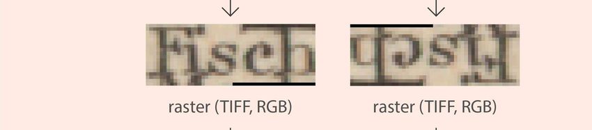
we used the combined input consisting of original, bringing those to a horizontal orientation. Our
rotated, and enhanced images for further processing. experiences revealed that Tesseract is incapable of
An accurate localization of all text areas is not reading text being rotated 10 degrees and more.
necessary since the final affine transformation requires Recognizing rotated text is an ongoing and still not
only three ground control points. solved challenge in OCR (Ye and Doermann, 2015; Yu
et al., 2017). However, map labels within the bounding
4.2 Text recognition boxes might be oriented in two directions. Firstly, right
side up in a readable form and secondly, upside down,
Utilizing the derived and unified bounding boxes, the rotated 180 degrees. The cropped text image areas were
occurrence of text elements within the map could consequently rotated through the rotation angle of their
precisely be located. This enabled an improved reading associated bounding boxes on the one hand and
of labels from the input map, the text recognition. As additional 180 degrees on the other hand.
can be seen from Fig. A1 in Appendix, our workflow
includes an extraction of all text image areas before
Table 2. Outputs from Strabo and Tesseract OCR as well as their Levenshtein Distance to current street names3 calculated
with the help of the fuzzywuzzy library.
Recognized string Ground truth string Average
Detected label Rotation Rotated by
by Tesseract OCR from current street Levenshtein
by Strabo angle rotation angle
(stringh) names3 (stringc) Distance
179° no >Speersort| Speersort 100.0%
1° no Catharıineıl Katharinenfleet 33.5%
179° no I Beichei Siebeneichen 33.5%
178° no chopenstehl Schopenstehl 98.0 %
3° no Nicola; Nieland 31.0%
no „ame - 0.0%
167°
yes HTollandısche Holländische Reihe 72.5%
no ren Wöhren, Cremon 0.0%
14°
yes ud Hude 33.5%
no AN - 0.0%
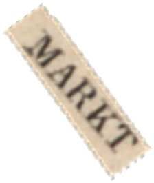
54°
yes | MARKT Marktweg 33.5%
no N - 0.0%
55°
yes Adolphs Br. Adolphsbrücke 84.0%
no - - -
88°
yes klopfen markt Hopfenmarkt 87.0%
An appropriate input data pool for an optical character and binary input images did not show any
recognition by Tesseract OCR was hereby created. As improvement.
the map’s original lossless PNG format performed poor
Regarding Tesseract’s output (examples shown in
for text recognition, all files were transferred in TIFF
Tab. 2), a reasonable number of text strings could be
and RGB color mode. Further testing with grayscale
AGILE: GIScience Series, 2, 12, 2021 | https://doi.org/10.5194/agile-giss-2-12-2021 8 of 14
recognized distributed over the entire map. Only minor                  detection and recognition rates are generally low
deviations from a manually prepared ground truth                        (
6 Data and software availability                                        Chiang, Y.-Y. (University of Southern California, Los
                                                                        Angeles, CA, USA): Personal communication, 2019.
All research data and applications produced and
                                                                        Chiang, Y.-Y. and Knoblock, C.: Strabo: A Complete
applied within this publication can be found at
                                                                        System for Label Recognition in Maps, 26th
https://doi.org/10.5281/zenodo.4721174        (Schlegel,
                                                                        International Cartographic Conference, Dresden,
2021). The repository is structured following Sect. 3 of
                                                                        Germany, 25–30 August 2013, 2013.
this paper.
                                                                        Chiang, Y.-Y. and Knoblock, C. A.: Recognizing text
The results were generated using QGIS Desktop 3.16.0
                                                                        in raster maps, GeoInformatica., 19, 1–27,
(approximate georeferencing, Sect. 3.6), the command
                                                                        https://doi.org/10.1007/s10707-014-0203-9, 2014.
prompt in Windows 10 OS (Tesseract OCR, Sect. 3.4),
the Linux (Ubuntu 18.04) command line via Windows-                      Chiang, Y.-Y., Moghaddam, S., Gupta, S., Fernandes,
Subsystem for Linux (Strabo, Sect. 3.2), as well as                     R. and Knoblock, C. A.: From map images to
several Jupyter Notebooks (additional adjustments,                      geographic names, in: SIGSPATIAL '14, Proceedings
Sect. 3.3 and string similarity, Sect. 3.5) written in                  of the 22nd ACM SIGSPATIAL International
Python. These scripts are available under the GNU                       Conference on Advances in Geographic Information
GPLv3 license.                                                          Systems, Dallas, TX, USA, 4-7 November 2014, 581–
                                                                        584, https://doi.org/10.1145/2666310.2666374, 2014.
The workflow underlying this paper was partially
reproduced by an independent reviewer during the                        Chiang, Y.-Y., Leyk, S., Honarvar Nazari, N.,
AGILE reproducibility review and a reproducibility                      Moghaddam, S. and Tan, T. X.: Assessing the impact
report            was            published      at                      of graphical quality on automatic text recognition in
https://doi.org/10.17605/osf.io/anv9r.                                  digital maps, Computers and Geosciences., 93, 21–35,
                                                                        https://doi.org/10.1016/j.cageo.2016.04.013, 2016.
                                                                        Chiang, Y.-Y., Duan, W., Leyk, S., Uhl, J. H. and
References                                                              Knoblock, C. A. (Eds.): Using Historical Maps in
Abdullah, A., Abo Alshamat, S. S., Bakhashwain, A.                      Scientific Studies. Applications, Challenges, and Best
and Aslam, A.: Automatic text removal and                               Practices,       Springer,    Cham,       Switzerland,
replacement in scanned meteorological thematic maps,                    https://doi.org/10.1007/978-3-319-66908-3, 2020.
JCS.,                    11,                  772–783,                  Fletcher, L. A. and Kasturi, R. A.: Robust Algorithm
https://doi.org/10.3844/jcssp.2015.772.783, 2015.                       for Text String Separation from Mixed Text/Graphics
Cao, R. and Tan, C. L.: Text/Graphics Separation in                     Images,          TPAMI.,          10,       910–918,
Maps, in: Graphics Recognition, Algorithms and                          https://doi.org/10.1109/34.9112, 1988.
Applications, Proceedings of the 4th International                      Freie und Hansestadt Hamburg, Behörde für
Workshop on Graphics Recognition, Kingston,                             Wirtschaft, Verkehr und Innovation: Straßen- und
Canada,       7-8    September     2001,    167–177,                    Wegenetz               Hamburg              (HH-SIB),
https://doi.org/10.1007/3-540-45868-9_14, 2002.                         https://suche.transparenz.hamburg.de/dataset/strassen-
Chen, L.-H. and Wang, J.-Y.: A system for extracting                    und-wegenetz-hamburg-hh-sib16?forceWeb=true,
and recognizing numeral strings on maps, in:                            2020.
Proceedings of the Fourth International Conference on                   Goto, H. and Aso, H.: Extracting curved text lines
Document Analysis and Recognition, Ulm, Germany,                        using local linearity of the text line, IJDAR., 2, 111–
18-20           August        1997,         337–341,                    119, https://doi.org/10.1007/s100320050041, 1999.
https://doi.org/10.1109/ICDAR.1997.619867, 1997.
                                                                        Hamburg, Germany, 1853 (Raster Image), Harvard
Chiang, Y.-Y.: Unlocking textual content from                           Map      Collection,    Harvard     College   Library,
historical maps – Potentials and applications, trends,                  https://maps.princeton.edu/catalog/harvard-g6299-h3-
and outlooks, in: Recent Trends in Image Processing                     1853-l5.
and Pattern Recognition, Proceedings of the
                                                                        Hanke, C.: Hamburgs Straßennahmen erzählen
International Conference on Recent Trends in Image
                                                                        Geschichte, 5th ed., Medien-Verlag Schubert,
Processing and Pattern Recognition, Bidar, India, 16-
                                                                        Hamburg, Germany, 2014.
17           December          2016,        111–124,
https://doi.org/10.1007/978-981-10-4859-3_11, 2017.

AGILE: GIScience Series, 2, 12, 2021 | https://doi.org/10.5194/agile-giss-2-12-2021                                    10 of 14
Iosifescu, I., Tsorlini, A. and Hurni, L.: Towards a Rosebrock, A.: OpenCV OCR and text recognition
comprehensive methodology for automatic with Tesseract:
vectorization of raster historical maps, e-Perimetron., https://www.pyimagesearch.com/2018/09/17/opencv-
11(2), 57–76, 2016. ocr-and-text-recognition-with-tesseract, last access: 13
November 2020, 2018b.
Kohlstock, P.: Kartographie, 1st ed., Ferdinand
Schöningh, Paderborn, 2004. Schlegel, I.: Empirical Study for a Deployment of a
Methodology for Improving the Comparability
Laumer, D., Gümgümcü, H., Heitzler, M. and Hurni,
Between Historical and Current Maps, KN – Journal of
L.: A Semi-automatic Label Digitization Workflow for
Cartography and Geographic Information., 69(2), 121–
the Siegfried Map, in: Automatic Vectorisation of
130, https://doi.org/10.1007/s42489-019-00016-0,
Historical Maps, Proceedings of the International
2019.
Workshop on Automatic Vectorisation of Historical
Maps, Budapest, Hungary, 13 March 2020, 55–62, Schlegel, I.: Label Extraction: v1.1.0 (Version v1.1.0),
https://doi.org/10.21862/avhm2020.07, 2020. Zenodo, https://doi.org/10.5281/zenodo.4721174,
2021.
Li, Z., Chiang, Y.-Y., Banisetti, S. and Kejriwal, L.:
strabo-text-recognition-deep-learning (Version 0.67), Simon, R., Pilgerstorfer, P., Isaksen, L. and Barker, E.:
GitHub repository, https://github.com/spatial- Towards semi-automatic annotation of toponyms on
computing/strabo-text-recognition-deep-learning, 2019. old maps, e-Perimetron., 9(3), 105–112, 2014.
Lin, H. and Chiang, Y.-Y.: SRC: Automatic Extraction Tessdoc: Tesseract documentation. Improving the
of Phrase-Level Map Labels from Historical Maps, quality of the output: https://tesseract-
SIGSPATIAL Special., 9(3), 14–15, ocr.github.io/tessdoc/ImproveQuality last access: 3
https://doi.org/10.1145/3178392.3178400, 2018. November 2020.
Mansurov, N.: JPEG Compression Levels in Photoshop Tofani, P. and Kasturi, R. (1998): Segmentation of text
and Lightroom: https://photographylife.com/jpeg- from color map images, in: Proceedings of the
compression-levels-in-photoshop-and-lightroom, last Fourteenth International Conference on Pattern
access: 12 April 2021, 2018. Recognition, Brisbane, Australia, 16–20 August 1998,
945–947, https://doi.org/10.1109/ICPR.1998.711391,
Milleville, K., Verstockt, S. and van de Weghe, N.:
1998.
Improving Toponym Recognition Accuracy of
Historical Topographic Maps, in: Automatic Tombre, K., Tabbone, S., Pélissier, L., Lamiroy, B. and
Vectorisation of Historical Maps, Proceedings of the Dosch, P: Text/Graphics Separation Revisited, in:
International Workshop on Automatic Vectorisation of Document Analysis Systems V., Proceedings of the 5th
Historical Maps, Budapest, Hungary, 13 March 2020, International Workshop on Document Analysis
63–72, https://doi.org/10.21862/avhm2020.01, 2020. Systems, Princeton, NJ, USA, 19–21 August 2002,
200–211, https://doi.org/10.1007/3-540-45869-7_24,
Nazari, H. N., Tan, T. and Chiang, Y.-Y.: Integrating
2002.
text recognition for overlapping text detection in maps,
Document Recognition and Retrieval., XXIII, 1–8, van Strien, D.: Living with Machines OCR hack:
https://doi.org/10.2352/ISSN.2470- http://livingwithmachines.ac.uk/living-with-machines-
1173.2016.17.DRR-061, 2016. ocr-hack, last access: 25 August 2020.
Pouderoux, J., Gonzato, J., Pereira, A. and Guitton, P.: Velázquez, A. and Levachkine, S.: Text/Graphics
Toponym Recognition in Scanned Color Topographic Separation and Recognition in Raster-Scanned Color
Maps, in: Proceedings of the Ninth International Cartographic Maps, in: Graphics Recognition, Recent
Conference on Document Analysis and Recognition, Advances and Perspectives, Proceedings of the 5th
Curitiba, Brazil, 23–26 September 2007, 531–535, International Workshop on Graphics Recognition,
https://doi.org/10.1109/ICDAR.2007.4378766, 2007. Barcelona, Spain, 30–31 July 2003, 63–74,
https://doi.org/10.1007/978-3-540-25977-0_6, 2004.
Rosebrock, A.: OpenCV Text Detection (EAST text
detector): Weil, S. et al.: Tesseract Open Source OCR Engine
https://www.pyimagesearch.com/2018/08/20/opencv- (main repository) (Version 4.1.1), GitHub repository,
text-detection-east-text-detector, last access: 27 https://github.com/tesseract-ocr/tesseract, 2020.
October 2020, 2018a.
AGILE: GIScience Series, 2, 12, 2021 | https://doi.org/10.5194/agile-giss-2-12-2021 11 of 14Weinman, J. (2013): Toponym recognition in historical Wilson, D.: Finding words in maps:
maps by gazetteer alignment, in: Proceedings of the http://livingwithmachines.ac.uk/finding-words-in-
12th International Conference on Document Analysis maps, last access: 25 August 2020.
and Recognition, Washington, DC, USA, 25–28
Ye, Q. and Doermann, D.: Text Detection and
August 2013, 1044–1048,
Recognition in Imagery: A Survey, TPAMI., 37, 1480–
https://doi.org/10.1109/ICDAR.2013.209, 2013.
1500, https://doi.org/10.1109/TPAMI.2014.2366765,
Weinman, J., Chen, Z., Gafford, B., Gifford, N., 2015.
Lamsal, A. and Niehus-Staab, L.: Deep neural
Yu, R., Luo, Z. and Chiang, Y.-Y. (2016): Recognizing
networks for text detection and recognition in historical
text in historical maps using maps from multiple time
maps, in: Proceedings of the 15th International
periods, in: Proceedings of the 23rd International
Conference on Document Analysis and Recognition,
Conference on Pattern Recognition, Cancun, Mexico,
Sydney, Australia, 20–25 September 2019, 902–909,
4–8 December 2016, 3993–3998,
https://doi.org/10.1109/ICDAR.2019.00149, 2019.
https://doi.org/10.1109/ICPR.2016.7900258, 2017.
AGILE: GIScience Series, 2, 12, 2021 | https://doi.org/10.5194/agile-giss-2-12-2021 12 of 14Appendix Figure A1: Workflow from label detection to recognition for a map subset including interposed further adjustments. AGILE: GIScience Series, 2, 12, 2021 | https://doi.org/10.5194/agile-giss-2-12-2021 13 of 14
Figure A2: Workflow for matching historical to similar current street names with the aim to perform a rough georeferencing.

AGILE: GIScience Series, 2, 12, 2021 | https://doi.org/10.5194/agile-giss-2-12-2021                                14 of 14
You can also read