Authority Monitoring Report 2019
←
→
Page content transcription
If your browser does not render page correctly, please read the page content below
Authority
Monitoring
 Report

   2019

             1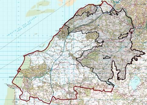
Foreword
The North Somerset Council Authority Monitoring Report (AMR) is published
each year. This AMR monitors the period 1 April 2018 to 31 March 2019.

The primary purpose of the AMR is to report on the performance of the
planning policies and the progress of emerging policy documents and North
Somerset Council remains committed to preparing and publishing a
monitoring report in this format each year.

Further copies of this document and those from previous years are available
on our website at www.n-somerset.gov.uk/planningpolicy

We welcome any comments on this document that would help us to
improve both the information and format of future reports.

For further information please contact:
      Planning Policy
      North Somerset Council
      Town Hall
      Walliscote Grove Road
      Weston-super-Mare
      BS23 1UJ

E-mail planning.policy@n-somerset.gov.uk
Tel: 01934 426 665

                                                                              2
Contents

Introduction                                       4

Local Development Plan                             5

Setting the scene in North Somerset                11
       Location                                    11
       Demographic structure                       12
       Dwellings, household types and tenure       12
       Socio-cultural issues                       13

Living within environmental limits                 14
       Climate change                              14
       Sustainable design and construction         16
       Environmental protection                    18
       Nature conservation                         20
       Landscape and the historic environment      23
       Green Belt                                  25
       Waste                                       26
       Minerals                                    28
       Transport and movement                      29

Delivering strong and inclusive communities        36
       High quality design                         36
       Scale of new housing                        37
       Distribution of new housing                 38
       Mixed and balanced communities              39
       Affordable housing                          42

Delivering a prosperous economy                    43
       Supporting a successful economy             43
       Retail                                      47
       Tourism                                     51
       Bristol Airport                             52
       Royal Portbury Dock                         53

Ensuring safe and healthy communities              54
      Children, young people and education         54
      Health                                       59
      Sport, recreation and community facilities   60

Duty to Co-operate                                 62

                                                        3
Introduction

The production of an Authority Monitoring Report (AMR) is a statutory
requirement.

The purpose of this report is to:

   ▪   Show how North Somerset’s emerging development plan documents
       are progressing;
   ▪   Show how well the policies in the adopted development plan
       documents are performing; and
   ▪   Where policies are not being implemented, explain why and set out
       what steps are being taken to ensure that the policy is implemented, or
       whether the policy should be amended or replaced.

Annual monitoring will also form the basis for review of any development plan
documents that are adopted.

                                                                                4
Local Development Plan
The development plan for North Somerset currently comprises the following
adopted documents and associated policies maps:
• North Somerset Core Strategy (2017)
• Sites and Policies Plan Part 1: Development Management Policies
(2016)
• Sites and Policies Plan Part 2: Site Allocations Plan (2018)
• West of England Joint Waste Core Strategy (2011)
• Backwell Neighbourhood Development Plan (2015)
• Long Ashton Neighbourhood Development Plan (2015)
• Claverham Neighbourhood Development Plan (2018)
• Yatton Neighbourhood Development Plan (2019)
• Congresbury Neighbourhood Development Plan (2019)
Core Strategy
Following an examination conducted by an independent Inspector, the North
Somerset Core Strategy was found sound and was formally adopted in April
2012. The adoption of the Core Strategy was subsequently challenged. The
High Court Judgment found that Policy CS13: Scale of new housing was
unlawful by reason of the Core Strategy Inspector’s failure to give ‘adequate
or intelligible reasons for his conclusions on the housing requirement figure.
As a result Policy CS13, along with other policies that could require
consequential changes if the housing requirement increased, were remitted
back to the Planning Inspectorate for re-examination. The re-examination took
place in two stages. Policy CS13 was re-adopted in 18 September 2015.
The second stage of the re-examination assessed whether any consequential
changes were needed to the other remitted policies as a result of the increase
to the housing requirement.
The Core Strategy remitted policies were adopted by the council on 10
January 2017.
Further details are available at www.n-somerset.gov.uk/corestrategy
Sites and Policies Plan Part 1: Development Management Policies
This development plan document contains the detailed development
management planning policies to deliver the adopted Core Strategy. It covers
a range of development issues including development in the Green Belt,
major transport schemes, conservation areas, extensions to dwellings,
development in the countryside, retailing, accommodation for older people,
minerals planning and design.
The plan was adopted by full council on 19 July 2016.
5For further details please visit www.n-somerset.gov.uk/sitesandpolicies
Sites and Policies Plan Part 2: Site Allocations Plan
The Site Allocations Plan allocates housing and employment sites to deliver
the Core Strategy requirements and defines the settlement boundaries for
towns and villages identified in the Core Strategy in order to direct
development to the most sustainable locations within North Somerset. The
plan also contains allocations and policies that will protect the environment
and provide additional facilities for leisure and social and community uses.
The plan was adopted on 10 April 2018.
Further details are available at www.n-somerset.gov.uk/sitesandpolicies
West of England Joint Waste Core Strategy
The four unitary authorities in the West of England area worked together to
produce this joint development plan document which was adopted in March
2011. The plan period runs until 2026. The strategy sets out the policies for
the provision of waste management infrastructure across the sub region.
The document is available at http://www.westofengland.org/waste-
planning/adopted-joint-waste-core-strategy.
Neighbourhood Development Plans
Neighbourhood Development Plans (NDPs) have now been made for five
areas within North Somerset; Backwell, Claverham, Congresbury, Long
Ashton and Yatton. As they are adopted, these form part of the local
development plan.
Plans are being prepared for a number of other neighbourhood areas within
the district.
The adopted plans and further information on those that are being prepared
can be viewed at www.n-somerset.gov.uk/neighbourhoodplans
6Emerging plans
The Local Development Scheme (LDS) sets out the programme for the
preparation of the Council’s suite of planning policy documents. It sets out
details of which documents are being produced, in what order, and when. The
LDS is reviewed on a regular basis to ensure it reflects the anticipated
programme accurately. The LDS is currently being revised. The last published
version is dated December 2018.
Joint Spatial Plan
The four West of England unitary authorities of Bath and North East
Somerset, Bristol, North Somerset and South Gloucestershire prepared a joint
strategic development plan called the Joint Spatial Plan (JSP). The JSP set
out the strategic policies for sustainable growth for the next 20 years.
The plan was submitted to the Secretary of State for examination in April
2018. In September 2019 the Inspectors appointed to examine the plan wrote
to the four authorities following an initial set of hearings, voicing concerns with
the strategy. The Council has subsequently resolved to withdraw from the
Joint Spatial Plan examination and will proceed with a new Local Plan.
Local Plan
A new Local Plan is being prepared by the Council.
The Local Plan will allocate sufficient housing and employment and identify
any associated necessary infrastructure. The Local Plan will also reassess,
and update where appropriate, policies and designations for the protection of
the natural and built environment and allocations for other land uses.
It will also contain a full suite of development management policies relating to
the use of land and buildings on topics such as retail, employment, residential
uses, design, flooding and drainage, waste and minerals, community facilities,
transport and other infrastructure.
An initial pre-commencement document was published in early 2016. As the
plan proposes a number of strategic development locations an early
consultation called ‘generating ideas’ was held for these areas in late 2017.
The plan has reached issues and options stage, and a three month
consultation period took place from September-December 2018.
Following the withdrawal from the Joint Spatial Plan, the Council will be
publishing an updated Local Development Scheme and starting work on a
new Local Plan afresh. This will begin with a pre-commencement document
consultation in January 2020, followed by an issues and options consultation
during the spring.
7Neighbourhood Development Plans
In addition to the five made plans for Backwell, Claverham, Congresbury,
Long Ashton and Yatton, a further nine Neighbourhood Areas have also been
designated. These are:
• Bleadon
• Churchill
• Clevedon
• Hutton
• Pill/Easton-in-Gordano and Abbots Leigh
• Portbury
• Portishead
• Winscombe and Sandford
• Wrington
These areas are at various stages of plan production and other parishes
within North Somerset have also expressed an interest in developing a
Neighbourhood Plan. Full details are kept up to date at www.n-
somerset.gov.uk/neighbourhoodplanning
8Supplementary Planning Documents
Whilst not formally part of the development plan, Supplementary Planning
Documents (SPDs) can provide more detail on certain aspects of the
development plan and clarify the interpretation of a policy or approach. Once
adopted, SPDs are material considerations in the planning process.
Current adopted SPDs:
• Accessible Housing Needs (2018)
• Affordable Housing (2013)
• Biodiversity and Trees (2005)
• Creating Sustainable Buildings and Places (2015)
• Development Contributions (2014)
• Employment Led Delivery in Weston-super-Mare (2014)
• Landscape Character Assessment (2018)
• North Somerset and Mendip Bats Special Area of Conservation (2018)
• Parking Standards (2013)
• Residential Design Guide part 1 (2013)
• Residential Design Guide part 2 (2014)
• Shopfront Design Guide (2019)
• Solar Photovoltaic Arrays (2013)
• Travel Plans (2010)
• Weston Villages (2012)
• Weston-super-Mare Town Centre Regeneration (2017)
• Wind turbines (2014)
All adopted and emerging supplementary planning documents are available to
download from www.n-somerset.gov.uk/spds
Community Infrastructure Levy
The Community Infrastructure Levy (CIL) is a charge which developers have
to pay per square metre of development towards the cost of infrastructure to
support development. The charge will that is payable varies according to the
size, type and location of the development.
Our CIL charging schedule took effect on 18 January 2018 and since its
adoption £95,856.58 of CIL income has been received.
Full details of the CIL, including the monitoring report, are available at www.n-
somerset.gov.uk/CIL.
9Topic areas
The Authority Monitoring Report is presented on a topic basis, for ease of
reference. The topics have been set out to mirror the themes in the Core
Strategy, which are:
• Living within environmental limits
• Delivering strong and inclusive communities
• Delivering a prosperous economy
• Ensuring safe and healthy communities.
Since the introduction of the National Planning Policy Framework (NPPF) and
the withdrawal of Government guidance on monitoring it is now a matter for
local authorities to decide what to include in their monitoring reports while
ensuring that they are prepared in accordance with relevant legislation.
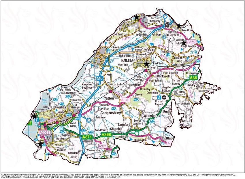
10Setting the scene in North Somerset
Location map
North Somerset covers an area of 39,080 hectares (151 square miles) and
has a population of 213,919 people1. The district contains an international
airport, a deep-sea west coast port, part of the Mendip Hills Area of
Outstanding Natural Beauty, a large area of Green Belt stretching south west
from the edge of Bristol, as well as areas of low-lying levels and moors. The
main settlements include the strategically significant town of Weston-super-
Mare and the three smaller towns of Portishead, Clevedon and Nailsea. The
M5 runs from north to south through the district and the mainline railway from
Bristol to the South West also crosses North Somerset stopping at five
stations along its route.
1 2018 Mid Year Population Estimate, Office for National Statistics
11Demographic structure
Population size
• The population of North Somerset is 213,919, an increase of 1,085
over the past year.
• The age breakdown for North Somerset is:
Aged 0-15 years – 18.2%
Aged 16-64 years – 58%
Aged 65 years and over – 23.8%
• Currently the proportion of people in North Somerset aged 65+ is
23.8%, compared to 22% in the South West and 18.3% in England and
Wales.
Source: 2018 Mid-Year Population Estimates, ONS
Ethnic composition
• At the 2011 Census the black and minority ethnic population made up
only 2.7% of North Somerset’s population compared to 4% of the
population in England.
Dwellings, household types and tenure
• At the 2011 Census there were 88,227 occupied households in North
Somerset. This means that on average there were 2.3 people living in
each household.
In North Somerset:
• 30.7% of households are single person households; nationally the
figure is 30.2%.
• 8.8% of households are lone parent households; nationally the figure is
10.6%.
• 50% of households are comprised of couples; nationally the figure is
45.3%.
• 36.8% of the population of North Somerset own their property outright
and 36.1% own their property with a mortgage or a loan. This means
that 72.9% of North Somerset residents are owner occupiers compared
to a figure of 63.5% nationally.
• 25.4% of the North Somerset population rent their properties.
Source: 2011 Census
12Socio-cultural issues
Crime rates and perception of safety
• During the monitoring period 15,452 crimes were recorded in North
Somerset. This is an increase on last year’s figure of 14,518 recorded
crimes.
Source: ONS
• 55% of North Somerset resident adults feel very safe or fairly safe
when outside in their local area after dark. 86% of adults feel very safe
or fairly safe when outside in their local area during the day. These
figures are lower than the last time the measure was recorded in 2014.
Source: North Somerset Residents Survey, October 2016
Unemployment rates
• The unemployment rate of people aged 16-64 in North Somerset is
2.8% for the period April 2018 to March 2019. This is a decrease on
the previous year’s figure of 3.6% and lower than the unemployment
rate of 3.1% across the South West.
Source: Annual Population Survey April 2018 to March 2019
Deprivation
• Within the Indices of Multiple Deprivation 2019 the local authority district
with a rank of 1 is the most deprived, and the area ranked 317 is the
least deprived. North Somerset is ranked at 221.
• North Somerset has 5 LSOAs within the most deprived 5% in England,
all within South and Central wards of Weston-super-Mare.
• There are 12 LSOAs within the least deprived 5% in England, these
are spread across the district.
Source: Indices of Multiple Deprivation 2019
13LIVING WITHIN ENVIRONMENTAL LIMITS
Climate Change
Climate Emergency
North Somerset Council is committed to reducing carbon emissions and tackling
climate change. The Core Strategy outlines principles that will guide development to be
more sustainable.
In February 2019 the council declared a Climate Emergency. A target to be carbon
neutral has been set by 2030 for both the organisation and the authority area. A
Climate Emergency Strategy and Action Plan has been produced to assist in achieving
these targets. Seven key principles have been identified aimed at addressing the
causes and consequences of climate change:
• Become a net zero carbon council
• An energy efficient built environment
• Replenish our carbon stores
• Adapting to climate change
• Renewable energy regeneration
• Reduce emissions from transport
• Repair, reuse, reduce and recycle
The report is available on our website at https://www.n-somerset.gov.uk/climatechange.
Work has been undertaken to identify possible rewilding sites throughout the district.
Once we have identified suitable sites, we will plant trees or let the grass grow longer.
This will enhance the natural environment and create new habitats for wildlife and
increase stored carbon.
Climate Local Commitment
In June 2013 the council signed up to the Climate Local Commitment. This was an
initiative to support carbon reduction and climate resilience led by the Local
Government Association (LGA). This scheme ceased in 2018.
Carbon Emissions
The Department of Business, Energy and Industrial Strategy provide data at local
authority level measuring industry/commercial, domestic and road transport carbon
emissions in tonnes. Figures are available from 2005 to 2017 and show there has been
a significant reduction in North Somerset.
Net Emissions
year estimate)
Emissions (t)
Grand Total
Industry and
Commercial
('000s, mid-
N. LULUCF
Population
Per Capita
Transport
Domestic
Year
2005 460.7 471.0 581.2 13.4 1,526.3 194.7 7.8
2006 474.0 475.3 567.7 12.2 1,529.2 197.0 7.8
2007 453.7 458.8 590.0 11.3 1,513.8 199.5 7.6
2008 440.2 458.9 578.8 10.5 1,488.4 200.9 7.4
142009 383.4 416.9 556.0 10.0 1,366.4 201.7 6.8
2010 409.9 444.5 546.5 9.2 1,410.1 203.0 6.9
2011 377.8 388.8 534.8 8.5 1,309.9 203.1 6.5
2012 404.7 422.5 541.4 8.0 1,376.7 204.5 6.7
2013 386.9 411.8 539.2 7.1 1,345.0 206.2 6.5
2014 283.5 343.2 543.8 6.8 1,177.3 208.2 5.7
2015 330.0 334.7 548.4 6.0 1,219.2 209.9 5.8
2016 307.4 320.7 584.9 5.9 1,218.9 211.7 5.8
2017 293.5 299.3 573.0 5.0 1,170.9 212.8 5.5
Carbon emissions in North Somerset 2005-2017
1550
1500
Carbon emissions (tonnes)
1450
1400
1350
1300
1250
1200
1150
2005 2006 2007 2008 2009 2010 2011 2012 2013 2014 2015 2016 2017
Year
The most significant reduction in carbon emissions has come from electricity
production. Both domestic and industrial & commercial sectors have reduced carbon
emissions from electricity by around 55% since 2005 with around 250 tonnes of carbon
being saved.
15LIVING WITHIN ENVIRONMENTAL LIMITS
Sustainable design and construction
Renewable energy
Large renewable energy and microgeneration schemes are supported by the council.
Renewable electricity produced in North Somerset, as at the end of 2018, is detailed
in the table below.
Generation (MWh)
Number of sites Capacity (MW) (2015)
Photovoltaic 6,777 80.0 79,233
Onshore Wind 5 0.034 71
Hydro 2 0.023 68
Anaerobic
Digestion 2 1.099 6,065
Landfill Gas 2 2.349 5,858
Total 6,788 83.496 91,295
Source: Department for Business, Energy and Industry
Carbon Reduction
North Somerset have reduced their carbon emissions from 7.8 tonnes per capita in
2005 to 5.5 tonnes per capita in 2017. The transport sector is one of the major
sources of carbon dioxide emissions.
New planning policy is currently in development for the new Local Plan to support
reduced carbon emissions. Work has been undertaken with other local authorities in
the West of England to evaluate the cost of zero carbon developments which will
inform policy creation.
There is an active community sector within the district. Local community groups have
formed in Clevedon, Nailsea, Failand & Long Ashton, Backwell, Winscombe &
Sandford, Pill and Portishead. The focus of the groups is to pledge practical local
action on climate change. A community initiative has formed called Zero West. This
aims to bring together community groups, renewable developers, local authorities
and other interested parties to work collaboratively towards a zero carbon West of
England.
The council has taken the following actions to reduce carbon emissions:
• Delivering sustainable development: Climate change mitigation and
adaptation requirements are set in policies CS1 and CS2 of the Core Strategy.
Energy efficiency in the housing stock is required alongside renewable energy
generation on new build properties.
• Sustainable transport schemes: investment in schemes such as MetroBus,
encouraging sustainable travel choices and a policy requiring travel
assessments/plans must be submitted with all major (>10 dwellings)
developments.
• NSC travel plan: a travel hierarchy is implemented where no travel is given
preference, and sets out carbon reduction targets.
16• Waste minimisation: increase in recycling rates to approximately 60% of
residual waste. Waste minimisation and reuse of raw materials reduces
energy use plus reduces GHG emissions associated with landfill.
• Domestic renewable energy: ECO funding and energy efficiency/fuel poverty
support. Increased efficiency leads to reduced energy use which in turn
reduces emissions.
• Street Lighting: where previously contributed approximately 25% of the
councils CO2 emissions, part night and dimming projects has reduced energy
use/CO2 emissions.
The council have also taken the following action to reduce the risks associated with a
changing climate:
• Flood risk management schemes: tackling the increase in flood risk from
extreme weather events and a changing climate.
• Biodiversity and green infrastructure planning policy: reducing the threats
posed to biodiversity by climate change. GI leads to cooling, carbon storage
and provides shading, increasingly required through increased temperatures.
• Community resilience – providing support for communities to cope in
extreme weather events.
Supplementary Planning Documents
The Creating Sustainable Buildings and Places SPD, Wind Turbines SPD and the
Solar Photovoltaic Array SPD are all adopted and available to view at
www.n-somerset.gov.uk/spds
17LIVING WITHIN ENVIRONMENTAL LIMITS
Environmental protection
Flood Risk
Policy CS3 of the adopted North Somerset Core Strategy relates to Environmental
Impacts and Flood Risk Assessment. Since July 2016 it has been supplemented by
adopted Policy DM1 on Flooding and Drainage in the adopted Sites and Policies
Plan: Part 1. One monitoring indicator identified is to review the Strategic Flood Risk
Assessment (SFRA) at regular intervals. The SFRA was produced as a series of
studies between 2008 and 2010, the outputs from which have been made available
on the council website at www.n-somerset.gov.uk/sfra. An update to the SFRA Level
1 has been commissioned and the council expects to take delivery in late 2019, after
which it will be published on the website. The flood risk mapping produced will
supersede the original Level 1 mapping and its partial updates.
As a Lead Local Flood Authority (LLFA), North Somerset has prepared a Local Flood
Risk Management Strategy (LFRMS) which outlines how we intend to manage local
flood risk within our area. Local flood risk means flooding from surface runoff,
groundwater and ordinary watercourses.
The LFRMS identifies objectives for managing local flood risk, proposes measures to
achieve these objectives and sets an action plan giving approximate timescales for
implementing these actions. The LFRMS can be viewed at http://www.n-
somerset.gov.uk/wp-content/uploads/2015/11/local-flood-risk-management-strategy-
summary-document.pdf
Environmental Impact Assessment (EIA)
Screening opinions
The council has a specific role within the Town and Country Planning (Environmental
Impact Assessment) Regulations 2017 to provide screening opinions on development
proposals. This is to determine whether a proposed development falls within the remit
of the Regulations, by whether it is likely to have any significant effects on the
environment. Screening should take place at an early stage in the decision of a
development but can occur after a planning application has been made.
The EIA Regulations list the types of development that may be subject to EIA within 2
separate Schedules. All projects listed in Schedule One will be subject to EIA and an
Environmental Statement will be required with a planning application. The council is
required to determine whether a proposal listed in Schedule Two of the Regulations
should be subject to EIA. An assessment is undertaken to determine whether these
projects are likely or unlikely to have significant effects on the environment. Where
significant effects are judged to be likely, a positive screening opinion is provided and
when significant effects are judged to be unlikely- a negative screening opinion is
provided.
Scoping opinions
If it is determined that a proposal is subject to EIA and an Environmental Statement
(ES) is required, the developer can apply to the council in writing for a Scoping
Opinion. This is guidance on the issues that will need to be addressed within the
submitted ES.
18Environmental policies
The adopted Core Strategy policy CS5: Landscape and the historic environment
seeks to protect and enhance North Somerset’s landscape and townscape as well as
the Mendip Hills AONB. The adopted Sites and Policies Plan Part 1: Development
Management Policies number DM11 seek to protect the Mendip Hills Area of
Outstanding Natural Beauty (AONB). These policies provide guidance on
development proposals within these areas.
19LIVING WITHIN ENVIRONMENTAL LIMITS
Nature conservation
Key assets
North Somerset has:
• 2 National Nature Reserves (NNR)
• 13 Local Nature Reserves (LNR)
• 204 Local Wildlife Sites (LWS)
• 56 Sites of Special Scientific Interest (SSSIs)
• 1 Ramsar
• 4 Special Areas of Conservation (SACs)
• 1 Special Protection Area (SPA)
• 75 Local Geological Sites (LGS)
• 1,024 Tree Preservation Orders (TPOs)
• 1 Area of Outstanding Natural Beauty
Source: North Somerset Council and Natural England
Local sites
Local sites include Local Wildlife Sites and Local Geological Sites. The 204
Local Wildlife Sites in North Somerset cover an area of 8509.39 hectares.
The condition of Local Sites is largely unknown as the majority are privately
owned. Local Sites are non-statutory sites so there is no obligation on
owners to protect or report on the features for which the site was
designated; or for them to allow their landholdings to be surveyed (unless
the designation happens to overlap with that of a SSSI). Therefore,
designated Local Wildlife Sites may include habitats that have been
damaged or destroyed through inappropriate management or neglect.
Sites of Special Scientific Interest (SSSIs)
SSSI condition is assessed by Natural England. 77.2% of North Somerset
SSSIs are in favourable condition. This greatly exceeds the national target
of 50% of SSSIs in favourable condition by 2020 set within ‘Biodiversity
2020’.
Hectares
Favourable 2,691.11
Unfavourable Recovering 441.19
Unfavourable No Change 278.46
Unfavourable Declining 64.80
Assessed area 3,483.70
Source: Natural England
Local Nature Reserves (LNRs)
Our 13 Local Nature Reserves (LNRs) cover a total of 291.424 hectares
across the district. The 2018 mid-year population estimates from the Office
for National Statistics gives the population of North Somerset as 213,919.
This provides a ratio of 1 hectare of LNR per 734 head of population, which
is well within Natural England’s access to natural green space target of 1
hectare of LNR per 1,000 head of population.
20Development Management
The natural environment policies in the Core Strategy seek to maintain and
enhance biodiversity through:
• meeting Biodiversity Action Plan targets,
• implementation of new Green infrastructure,
• safeguarding and enhancing through new development,
• protecting designated sites and important habitats, and
• promoting native tree planting.
Ecological consultation responses provided to Development Management
ensure that the above aims are implemented within submitted ecological
reports and landscaping plans. Policies CS4 and DM8 support the
negotiation of reasonable avoidance and mitigation of harm to site
biodiversity (prioritising protected sites and species; and Section 41 habitats
and species) and the pursuit of opportunities to enhance site biodiversity.
Within the ecological assessment, it is considered essential to secure locally
appropriate ecological landscaping and management of retained open
spaces (subject to other required designated use constraints, e.g. play
areas), particularly for major application sites; and to negotiate sufficient
habitat on the boundaries of sites (proportionate to size of site) to retain
sufficient wildlife corridor network.
A sufficient boundary buffer habitat is essential for bats and other wildlife
that needs to migrate and interbreed with other populations for genetic
exchange. A significant proportion of native planting is required within
landscaping plans to increase the likelihood of provision of essential specific
larval food plants for insects; and other ornamental planting required to
have some recognised wildlife benefit (nectar, seeds, berries). External
lighting conditions are also secured to avoid harm to light sensitive species
of bats and other nocturnal wildlife.
Projects
North Somerset Levels and Moors Restoration Project
The North Somerset Levels and Moors Restoration Project was established
by the Avon Wildlife Trust in 2011 to assess the condition of the North
Somerset Levels and Moors and identify the most valuable wildlife areas. In
June 2015 Wessex Water awarded the trust five years of funding to develop
and deliver conservation objectives. This includes work on protecting the
SSSI working with farmers and local landowners.
In 2016 the trust was awarded funding to focus on more comprehensive soil
testing and soil structure analysis along with nutrient planning, ditch
management and, if applicable, parasite analysis and livestock
management at 15 priority farms. The Avon Wildlife Trust is continuing to
work with partners including Natural England, Environment Agency, Internal
Drainage Board and the council and so far five kilometres of ditches have
been restored, providing an improved wildlife habitat.
In April 2018 the Avon Wildlife Trust received funding from the Biffa Award
to contribute to a project encouraging lapwings back to the Gordano valley.
21The grant will go towards work across 80 hectares of land between
Clevedon and Portishead to create suitable habitats for breeding pairs.
Portishead Ecology Park and Portbury Wharf Nature Reserve
The Portishead Ecology Park provides flood storage capacity for the Port
Marine development in the form of an attenuation pond and scrapes. It’s
also designed to provide recreational public open space as well as an
ecological corridor in combination with the designated Portbury Wharf
Nature Reserve, wider area of the Severn Estuary and open countryside
including the Gordano Valley. Together these sites comprise a mosaic of
valuable wetland habitats (including ponds, scrapes and rhynes), grazing
marsh, meadows, and hedgerows - supporting a variety of protected and
notable species including amphibians (including great crested newts),
schedule 1 birds (including barn owl) nesting birds, wading birds and
wildfowl, bats, reptiles, water vole, otter and invertebrates.
22LIVING WITHIN ENVIRONMENTAL LIMITS
Landscape and the historic environment
Heritage sites
North Somerset has:
• 32 Conservation Areas
• 1,100 Listed Buildings
• 68 Scheduled Monuments
• 8 Registered parks and gardens
• 58 Unregistered parks and gardens
Source: Historic England / North Somerset Council
Historic Environment
It is the council’s aim for the historic environment to be maintained and
protected. Any development affecting conservation areas, listed buildings,
scheduled monuments, registered parks and gardens and archaeological
sites should be appropriate and seek to enhance and reflect the character
of the protected area.
Historic England ‘Heritage at Risk’ Register
Six sites within the district are on the Heritage at Risk Register 2019. Three
of these sites are Listed Buildings and three are Scheduled Monuments.
The three Listed Buildings at risk are:
• Ashton Court, Long Ashton (Grade I listed)
• St Mary’s Church, Portbury (Grade I listed – place of worship)
• Birnbeck Pier, Weston-super-Mare (Grade II* listed)
The three Scheduled Monuments at risk are:
• Elms Colliery, Nailsea (the buildings are also Grade II listed)
• Worlebury Camp: a large multivallate hillfort on Worlebury Hill,
Weston-super-Mare
• Long barrow 350m south west of Cornerpool Farm, Wrington
Conservation Areas
There are currently no Conservation Areas on the Heritage at Risk Register.
Congresbury Conservation Area’s Appraisal and Management Plan was
adopted on 23/10/2019.
A proposed new conservation area for Churchill is due to be adopted in
January 2020.
Heritage Projects
Great Weston Heritage Action Zone (HAZ)
Weston-super-Mare was awarded Heritage Action Zone status by Historic
England in March 2017.
The project has produced a Historic Landscape Character Assessment for
Weston-super-Mare and the surrounding areas, as well as aerial
photography and mapping. The information from these projects are publicly
available on the North Somerset Historic Environment Record. Other
23projects include the designation of a new Conservation Area for Weston-
super-Mare (an amalgamation of existing conservation areas plus a new
designation for the High Street). This work included the creation of
Appraisals and Management Plans for each of the character areas, and the
Conservation Area was adopted in January 2019. A Shopfront Design
Guide (Supplementary Planning Document) was subsequently adopted, in
September 2019.
Weston-super-Mare has also been awarded a second HAZ grant from the
High Street HAZ scheme of £1.2m and will focus on southern High Street
around Oxford Street and North Walliscote Road. Projects will look to
transform disused historic buildings into shops, houses and community
centres. The funding will also help traditional businesses adapt to better
compete with online outlets.
Historic Environment Record
The North Somerset Historic Environment Record (NSHER) is published on
the council’s website at www.n-somerset.gov.uk/HER.
Layers available to view on the HER interactive map are:
• Conservation Areas
• Scheduled Monuments
• Registered Historic Parks and Gardens
• Unregistered Parks and Gardens
• Archaeological Sites
• Historic Landscape Characterisation
• Events (e.g. excavation & survey reports)
• Listed Buildings
A five-year Action Plan was implemented in 2017, to significantly enhance
the HER, including procedures and policies, as well as streamlining the
service by offering an online request form. In July 2019 a ‘priority’ service
was introduced, meaning that customers can access information from the
NSHER within 5 working days.
Over the last year work has progressed on adding information to the HER
database, as well as adding specific datasets such as the Northern Mendip
Hills National Mapping Programme project.
Local Plan policies
Heritage and Policy officers will review the current heritage policies for the
new Local Plan, to ensure they are in line with national legislation and
frameworks.
24LIVING WITHIN ENVIRONMENTAL LIMITS
Green Belt
Size of the Green Belt
The size of the Green Belt within North Somerset is 154.9 square
kilometres, which covers 40% of the district. There has been no change to
the Green Belt during the monitoring period.
© Crown copyright and database rights 2019 Ordnance Survey 100023397. You are not permitted to copy, sub-
license, distribute or sell any of this data to third parties in any form.
Development within the Green Belt
Through the planning system the council seek to protect the Green Belt
from inappropriate development with no net loss of the Green Belt area. An
application for a 47 bedroom hotel was approved in Felton, however, the
proposal is on previously developed land and was not considered to affect
openness.
25LIVING WITHIN ENVIRONMENTAL LIMITS
Waste
New waste management facilities
No planning applications for waste management facilities were approved in
North Somerset during the monitoring period.
Joint Waste Core Strategy
North Somerset, Bath and North East Somerset, Bristol and South
Gloucestershire have an adopted West of England Joint Waste Core
Strategy (JWCS).
In accordance with the waste hierarchy, the JWCS focuses on waste
prevention, re-use, recycling and recovery of value from waste, with the
ultimate aim to divert waste away from landfill. The West of England
authorities are committed to meeting the sub-region’s needs and the timely
provision of sufficient waste infrastructure.
Delivering the JWCS relies upon a robust monitoring system. This is set out
in section 7 of the JWCS. The tables below show monitoring results for the
JWCS for North Somerset, against key indicators, for 2018/19. A copy of
the adopted JWCS document is available to view at www.westofengland.org
Recycling/Composting
Unitary Authority Capacity of Capacity lost Capacity Capacity
applications during operational at permitted but
approved 2018/19 31/03/2019 not
during 2018/19 (tonnes) (tonnes) operational at
(tonnes) 31/03/2019
(tonnes)
North Somerset 0 0 268,200 0
Recovery
Zone & Capacity of Capacity Capacity Capacity Electricity
indicative applications lost during operational permitted and/or heat
requirement approved 2018/19 at but not output
for residual during (tonnes) 31/03/2019 operational from
waste 2018/19 (tonnes) at operational
treatment (tonnes) 31/03/2019 recovery
capacity as set (tonnes) facility
out in the (MW)
JWCS
A~390,000tpa 0 0 5,000 0 0
E~100,000tpa 0 15,000 0 1.1
0
Total for North 0 20,000 0 1.1
Somerset 0
26Hazardous/Non-Hazardous Landfill – N/A
Inert Landfill
Unitary Site Name Capacity of Landfill Landfill Landfill
Authority applications capacity operational permitted
approved which at but not
during became 31/03/2019 started at
2018/19 unavailable (tonnes) 31/03/2019
(tonnes) during (tonnes)
2018/19
(tonnes)
North Durnford Quarry 0 0 Approx 0
Somerset 382,500
tonnes per
annum for
20 years
(2012-
2032)
North Lulsgate Quarry, 0 0 Unspecified 0
Somerset Felton quantity of
restoration
material
and
finishing
top soils to
be
imported to
allow for
restoration
of quarry to
Nov 2021
Commentary
There has been no change from the 2017/18 situation regarding extant
planning permissions for waste facilities in North Somerset, taking account
of all the above waste categories: recycling and composting, recovery,
hazardous/non- hazardous landfill and inert landfill.
27LIVING WITHIN ENVIRONMENTAL LIMITS
Minerals
Production of primary land won aggregates and secondary and
recycled aggregates
We are unable to publish details of the amount of primary land won
aggregates in North Somerset for 2018, the latest year for which figures
have been obtained, due to confidentiality issues. Data on production of
crushed rock across the West of England sub region in recent years is
available in the published annual reports of the South West Aggregates
Working Party.
Landbank of crushed rock
The adopted Core Strategy Policy CS8 relates to minerals and states that
the council will seek to maintain a landbank for crushed rock of at least 10
years. Currently the calculated landbank is in excess of 10 years. This
indicator will be monitored and reported annually.
28LIVING WITHIN ENVIRONMENTAL LIMITS
Transport and movement
Transport accessibility
The working population of North Somerset use the following types of transport to
travel to work:
• Public transport 5.5%
• Car 68.5%
• Walking 9.5%
• Cycling 2.8%
Nationally the figures are:
• Public transport 16.4%
• Car 57.5%
• Walking 10.7%
• Cycling 2.9%
Over 37% of the working age population travel over 10km to work.
Source: 2011 Census Travel to work statistics
Car ownership
The total number of cars owned in North Somerset at the time of the 2011 Census
was 121,381. The percentage of households without access to a car was 17.2%,
compared to 26% nationally. The percentage of households with 2+ cars was 41.3%,
compared to 32.2% nationally.
Source: 2011 Census
Traffic
In 2018 motor vehicle traffic in North Somerset was 1,600 million miles, an increase
from 1,549 million kilometres in 2017. Department for Transport figures show traffic
growth of 30% on North Somerset roads between 2000 and 2018.
Source: Department for Transport Road Traffic Statistics
In 2017 there were 56 reported killed and seriously injured casualties on North
Somerset roads. This is an increase on the 2017 figure of 53.
Source: Department for Transport Reported Road Casualties Great Britain: 2018 Annual Report
Joint Local Transport Plan
The West of England Joint Local Transport Plan (JLTP3), prepared in 2011, set out a
15-year vision for transport across the region. It focussed on reducing carbon
emissions, supporting economic growth, and improving accessibility, safety and
security, health, and quality of life. The region has made significant achievements
during the eight years of JTLP3, spending over £500m on the delivery of transport
projects.
The JLTP3 is now largely out of date due to numerous national and regional planning
and transport changes. In the West of England these include the emerging regional
planning for residential and employment growth and the Joint Transport Study (JTS).
For the wider region this includes the emerging Western Gateway Sub-National
Transport Body. National announcements from the Department for Transport (DfT)
will continue to influence North Somerset and the wider West of England, such as
removal of the Severn Tolls, proposals for a Major Road Network and the need to
embrace technological advances in the transport sector (including electric and
autonomous vehicles). Regional announcements and policy shifts such as the need
29for Clean Air Zones (CAZ) in Bristol and Bath and increased momentum behind long-
heralded Mass Transit network for the Greater Bristol area, as well as local
announcements such as the Climate Emergency Motion and subsequent Climate
Emergency Strategy and Action Plan by North Somerset Council, have increased the
need for an updated JLTP.
A new Joint Local Transport Plan (JLTP4) has been drafted to cover the period 2019
to 2036. It is a joint plan prepared with North Somerset Council’s West of England
partners, consisting of Bath & North East Somerset Council, Bristol City Council,
South Gloucestershire Council and the West of England Combined Authority
(WECA). Consultation took place in February & March 2019 and all the necessary
updates to the plan, including those from the consultation, are being finalised. The
plan is due to be adopted by North Somerset Council and the West of England early
in 2020.
A copy of the consultation draft can be viewed at: https://s3-eu-west-
1.amazonaws.com/travelwest/wp-content/uploads/2015/05/Full-Draft-JLTP4.pdf.
Rail
The council aims to increase transport choice and promote accessibility by
maximising and developing the transport network and reducing congestion. The
North Somerset Core Strategy together with policies in the Sites and Policies Plan
Part 1 document sets out that only acceptable railway related development on
safeguarded land will be supported. No major improvements have been completed
during the monitoring period.
Rail Station Usage
The need to provide an increase in transport choice and reduce congestion can be
indirectly monitored through the number of passengers using the rail service in North
Somerset.
Estimates of station usage, entries and exits, for each station in North Somerset are
detailed in the table below. All stations saw an increase in patronage except Weston-
super-Mare which saw a slight decline.
Station Name 2017/18 Entries 2016/17 Entries & % Change
& Exits Exits
Nailsea & Backwell 507,296 504,048 0.6%
Weston Milton 71,900 68,594 4.8%
Weston-Super-Mare 1,145,068 1,147,588 -0.2%
Worle 322,548 321,306 0.4%
Yatton 469,210 443,806 5.7%
Estimates of Station Usage 2017-18, Office of Road and Rail
Promoting non-car modes of transport has been identified as a key issue in the Joint
Local Transport Plan and station improvements schemes should help to improve
both rail use and sustainable travel to stations in the future.
30Parking
The council completed an application to the Department for Transport (DfT) to adopt
Civil Parking Enforcement powers (CPE) and from April 2017 the council took
responsibility for on-street parking enforcement from the police who were previously
responsible. CPE enables improved enforcement of parking regulations which leads
to better parking in areas where there are restrictions, as well as improved turnover
of parking spaces – supporting town centres and shopping streets by making it easier
for visitors and shoppers to park.
CPE helps to improve safety of pedestrians and road users. Other benefits include:
• ensures fair access to parking
• acts a deterrent to inconsiderate and dangerous parking
• alleviates congestion and pollution by keeping the highway open for the free
flow of traffic
• reduces the abuse of disabled parking spaces, leaving them free for genuine
blue badge holders
• increases access and response times for emergency vehicles
• improves safety outside schools
Further details are available at www.n-somerset.gov.uk/parking
Walking, cycling and Rights of Way network
The council aims to increase transport choice and promote accessibility by
maximising and developing the transport network and reducing congestion. This can
also have other benefits such as improving the health and wellbeing of the
population. We are working towards expanding and improving strategic cycle routes,
pedestrian links and multi user routes.
The England Coast Path Reports were published in the summer and following the
consultation stage with stakeholders and landowners were submitted to the
Secretary of State for determination. It is anticipated that the Secretary of State will
approve the NSC chapters in early 2020 after which works can be tendered and
consents obtained where required.
The Public Rights of Way Team resolved 392 maintenance and obstruction issues on
the network in the last twelve months. This has included 127 stiles removed and
replaced with metal self-closing pedestrian gates and 22 bridge structures repaired or
renewed. Work has also continued on the legal side dealing with numerous PRoW
diversion applications. Definitive Map Modification applications now have to adhere
to deadlines directed by the Secretary of State.
Cycling
The council is committed to improving key cycle routes. The Brean Down Way - part
of our ambitious Coastal Towns Cycle Route (CTCR) - records around 70,000 -
100,000 journeys per year. It is currently being extended to Weston-super-Mare
alongside Uphill Road North and will be open Summer 2020.
Now that planning permission and all other permissions have been secured for the
crucial Tutshill section of the Weston to Clevedon section of the CTCR has now been
obtained we have secured £640K from the Rural Payments Agency for this route. A
31bid for a further £1.3M has been received very favourably by Highways England. We
hope to have all the funding in place to deliver this long awaited scheme by 2021.
Together with the other West of England authorities our joint LCWIP (Local Cycling
and Walking Infrastructure Plan) has been submitted to the DfT and consultation is
imminent. We also have also prepared a comprehensive draft Active Travel Strategy
which we expect to have adopted by Spring 2020.
We have continued to offer free Bikeability training, using DfT Bikeability grant-
funding with some match-funding provided by North Somerset Council. Over 40
schools have engaged with the training. During 2018/19, the following places were
delivered:
Number
delivered Course contents
Bikeability Balance
(children in
Reception)
120 Learning to ride
Bikeability Level 1 Cycle control - off
(children in Year 4) 691 road
Bikeability Level 1/2 On road cycle
(children in Year 5/6) 1352 training
On road cycle
Bikeability Level 3
training including a
(Years 7-9)
425 journey
Bikeability Fix
38 Cycle maintenance
School Travel Plans
On a termly basis we send a newsletter containing guidance and information about
national and regional campaigns related to active and sustainable travel to school
and road safety initiatives.
We encourage the use of Modeshift STARS to create school travel plans and support
planning applications. Modeshift STARS is a national awards scheme that
recognises schools that have shown excellence in supporting cycling, walking and
other forms of sustainable travel. The application process provides an online
template that upon completion will generate a national standard school travel plan.
Our annual monitoring and reporting of mode of travel to school is held in a
dashboard format. Schools are provided with summary documents showing analysis
of their pupils’ travel and comparison to similar schools as well as mapping
information. School Mode of Travel Data is also accessible to council officers via a
mapping system which shows recommended walking and cycling zones, likely routes
and the frequency they are used.
Workplace and Residential Travel plans
Travel Plans are a planning requirement for all new large or expanding developments
as well as some smaller ones where there is expected to be a significant transport
32impact. Our Travel Plans Supplementary Planning Document (SPD) sets out the
detail of what is expected from a developer to mitigate the transport impacts of their
development and encourage more sustainable travel. Major planning applications
that were decided during 2018/19 secured 3 residential travel plans and 1 travel plan
relating to business.
The council continues to promote, help and support organisations and businesses
with a planning requirement for a Travel Plan and also those who are voluntarily
developing a Travel Plan. This includes the promotion of sustainable travel initiatives
and awareness campaigns under the brand Travelwest
(www.travelwest.info/businesses) - such as the Travelwest Challenge and the Travel
to Work Survey jointly organised by the four local authorities that make up the West
of England Partnership. All initiatives are recognised at the yearly Travel Awards
ceremony.
Transport improvement schemes
The Council aims to improve transport connectivity by encouraging sustainable
transport choices wherever possible and to promote accessibility by developing the
transport network for all travel modes.
Work has progressed on the following major transport schemes:
• MetroWest Phase 1: Portishead to Bristol Railway Line – the reopening of
the disused Portishead branch line to Bristol, with new stations at
Portishead and Pill, is North Somerset’s key rail priority. Funded by the
Department for Transport, the West of England Local Enterprise
Partnership’s Local Growth Fund and contributions from the five West of
England authorities, this major transport enhancement package will
support economic growth, improve transport resilience, increase
accessibility to the rail network, and improve quality of life. A major
milestone was reached in November 2019 with the submission of the
Development Consent Order (DCO) to the Planning Inspectorate for
review.
• Banwell Bypass – in October 2019 the Council won funding from the
Ministry of Housing, Communities & Local Government through the
Housing Infrastructure Fund (HIF) to build a bypass to the north of the
historic village of Banwell. A long-standing aspiration for both the Council
and the residents of Banwell, the bypass will provide numerous benefits,
including providing significant improvements to air quality and public realm
in the centre of the village, improved access to residential and employment
growth to the north-west of the village, supporting the delivery of Weston
Villages; and improving local and regional connectivity for longer trips. The
bypass will also allow the reallocation of road space in the centre of the
village to more sustainable modes of transport wherever possible, to
improve accessibility and quality of life for Banwell residents. Construction
is planned to begin in 2023 and be complete by the end of 2024.
• Weston Town Centre Transport Enhancements Scheme – the design for
this important town centre public realm and sustainable transport
33improvements scheme has been finalised and construction is due to start
in early 2020. The works, which include the creation of a centralised bus
interchange at the east end of Alexandra Parade, will support the
regeneration and rebranding of the town, improve the arrival experience to
visitors of the town in this key gateway area and encourage modal shift
through improved pedestrian, cycle and bus interchange facilities.
• North/South Link Road, Locking Parklands – This link from the A371 to
A370 West Wick Roundabout through Locking Parklands is a key part of
the access strategy for the Weston Villages and will provide access to the
development from either side. Construction work commenced in
November 2018, has continued through 2019 and is due to be completed
by January 2021.
• Tutshill Sluice – the delivery of an attractive ‘pier to pier’ cycle route
between Weston and Clevedon, as part of the North Somerset Coastal
Towns Cycle Route, has been a long-held Council ambition. This strategic
cycle scheme, which will generate tourism, provide for commuters and
encourage leisure cycling, won funding from the European Rural Growth
Fund in early 2019 to fund part of the works. The Council is engaging with
Highways England to fund the rest of the works and so far the signs are
positive to secure the capital to implement what will be a flagship
commuter & leisure route for the West of England.
• M5 Junction 19 – Funding has been granted by the Department for
Transport & Highways England to deliver interim improvements around
junction 19. Some of the money is earmarked to widen a section of the
A369 at Wyndham Way. This scheme will reduce the evening peak time
queues that currently build up for traffic heading towards Portishead.
Reducing those queues is key to facilitating any further improvements at
J19 itself. Consultation has taken place and improvements to the scheme
design made as a result of the comments received. Construction is
expected to start in December 2019.
• Uphill Road North – The Coastal Towns Cycle Route has been completed
between Uphill village and Brean (The Bean Down Way) and this already
generates 75,000 trips cycling and walking per annum. This next phase will
deliver a 3m wide shared use path for walking and cycling between Uphill
and Weston Seafront (for onward connection to Weston Town Centre). It is
needed for local usage as well as school, commuting, leisure and tourism
journeys. Major progress has been made this year with finalising design
and moving badger sets from the nearby golf course. Construction is due
to begin early in 2020 with the aim of opening the route in the summer
(also 2020).
Air Travel
Bristol Airport is the largest airport serving the South West, providing an important
facility for both leisure and business needs as well as providing employment
opportunities in the local area.
The Bristol Airport 2018 Operations Monitoring Report provides information on the
activity at the airport over 2017. Some key figures are:
34• There was a total of 76,212 aircraft movements, an increase of 3% over the past
year.
• The number of passengers increased by 8% to a total of 8,232,628.
• Over 805,500 passengers used the Bristol Flyer Airport Express bus service to
Bristol.
• An estimated 12.5% of air passengers used public transport for their journey to or
from the airport.
• The number of full time equivalents employed at the airport is 3,459, up from
3,070 on the previous year. The number of companies operating at the airport is
54.
Bristol Airport is planning on expanding its capacity to 12 million passengers a year.
Further details are available at www.bristolairportfuture.com
35DELIVERING STRONG AND INCLUSIVE COMMUNITIES
High quality design
Housing Quality and Design
The council is committed to supporting high quality design in new housing
development. The Core Strategy identifies the importance of this in policy
CS12: Achieving high quality design and place making. The policy suggests
that in designing new developments of 10 or more dwellings, applicants should
demonstrate how they meet the Building for Life criteria.
Policy DM32: High quality design and place making of the adopted Sites and
Policies Plan Part 1 sets out criteria against which planning applications will be
determined. The Weston Villages SPD sets out further specific detailed
guidance for this major mixed-use development area.
Two Residential Design Guide SPDs have been adopted. Section 1 covers
protecting the living conditions of neighbours (adopted January 2013) and
Section 2 details appearance and character of house extensions and
alterations (adopted April 2014). These documents are available to download
from our website at www.n-somerset.gov.uk/SPDs. Other guidance has been
produced to aid high quality design including a Development Management
Advice Note on recycling and waste (September 2013) and a Highways
Development Design Guide (December 2015).
Sustainable Buildings and Places
Policy CS2 of the Core Strategy relates to delivering sustainable design and
construction. The policy states that when considering proposals for
development the council will require energy efficient designs and the use of
on-site renewable energy.
The policy also refers to the Code for Sustainable Homes and the Lifetime
Homes scheme. The Government released a Written Ministerial Statement in
March 2014 stating that the Code for Sustainable Homes and the Lifetime
Homes schemes would be wound down and replaced with a simplified system
incorporated into Building Regulations. The policy also references BREEAM
standards which ensures buildings are of sustainable design and construction.
The Creating Sustainable Buildings and Places in North Somerset
Supplementary Planning Document was adopted in March 2015. The
document has been produced to support policy CS1: Addressing climate
change and carbon reduction and CS2: Delivering sustainable design and
construction of the Core Strategy. The document also updates policy CS2
following the change in national policy.
36You can also read


