Archaeological Impact Assessment Report Abbey Grounds, Co. Wicklow - Wicklow County Council
←
→
Page content transcription
If your browser does not render page correctly, please read the page content below
Yvonne Whitty
                       Unit 10,
                       Riverside Business Centre,
                       Tinahely,
                       Co. Wicklow

Archaeological Impact Assessment
     Report Abbey Grounds,
          Co. Wicklow.

   Archaeological Monument Ref: WI025-012002

         Protected Structure ref: WTC-RPS24

              ITM E 731199, N 694075

                    On behalf of:
                MosArt Architecture
                          For
              Wicklow County Council

                   Prepared By:

                   Yvonne Whitty
                  19th September 2021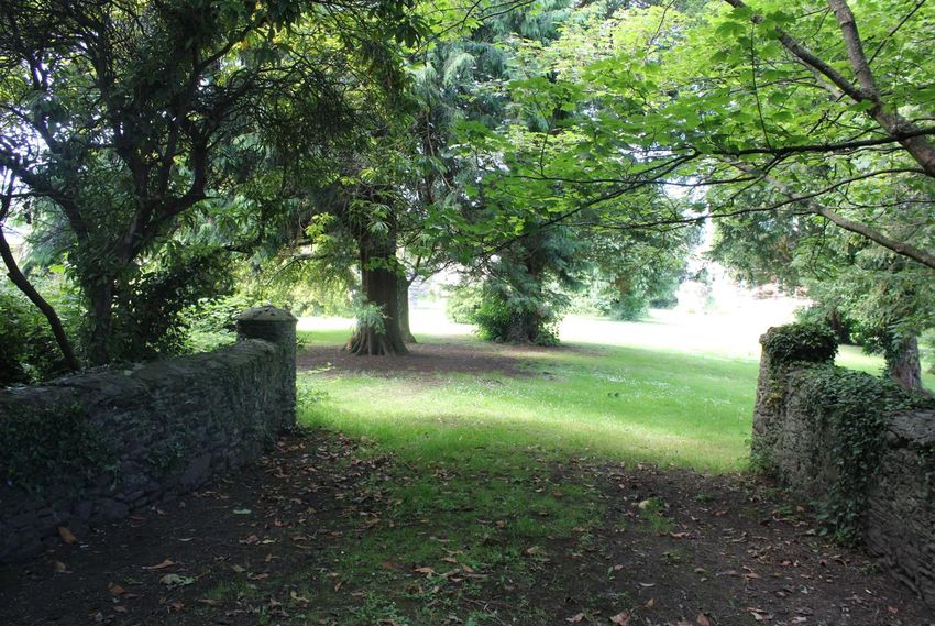
Preliminary Archaeological Impact Assessment Abbey Grounds County Wicklow.

Contents
1     Introduction .................................................................................................................... 1
2     Location description ....................................................................................................... 1
3     Description of Development ........................................................................................... 5
4     Legislative Background .................................................................................................. 7
5     Receiving Archaeological and Historical Environment .................................................... 8
    5.1     National Monuments ............................................................................................... 9
    5.2     Record of Monuments & Places and Sites & Monuments Record ........................... 9
    5.3     Database of Irish Excavation Reports ................................................................... 13
    5.4     Topographical files of the National Museum of Ireland; ......................................... 14
    5.5     Cartographic analysis; .......................................................................................... 15
    5.6     Place name Analysis............................................................................................. 18
    5.7     Record of Protected Structures for Wicklow Council (WCC). ................................ 27
6     Impact Assessment ...................................................................................................... 27
    6.1     Receiving Archaeological Environment ................................................................. 27
    6.2     Development Impacts ........................................................................................... 30
7     Archaeological Mitigation ............................................................................................. 33
8     References .................................................................................................................. 35

Figures
Figure 1: Site Location Abbey Grounds Co. Wicklow. ........................................................... 1
Figure 2: 3-D View of development supplied by MOS Art. ..................................................... 5
Figure 3: Amphitheatre development plans supplied by MosArt. ........................................... 6
Figure 4: Café extension to Coach House. ............................................................................ 6
Figure 5: Service route and pathways. .................................................................................. 7
Figure 6: Benches and pods. ................................................................................................ 7
Figure 7: Extract from published RMP map sheet 25 showing zone of notification for Wickow
Town. The Abbey is located within this notification zone. ...................................................... 8
Figure 8: RMP sites in Wicklow Town. ................................................................................ 12
Figure 9: RMP sites and zones of notification within the vicinity of the Abbey grounds site
which is outlined in red. ....................................................................................................... 12
Figure 10: Excavations within the vicinity of and within the friary. ........................................ 13
Figure 11: Extract from Figure 13 Geophysical Survey (Curran, 2018). .............................. 14
Figure 12: Extract from the Down Survey, William Petty, c.1656 Wicklow Scale of 160
perches to 1 inch (downsurvey.tcd.ie). ................................................................................ 16
Figure 13: Extract from Jacob Neville’s Map of County Wicklow from 1760. ....................... 16
Figure 14: First edition ordnance survey map with site outline marked in blue c.1838 (source
www.archaeology.ie). .......................................................................................................... 17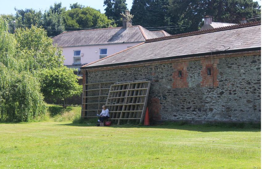
Preliminary Archaeological Impact Assessment Abbey Grounds County Wicklow.

Figure 15: Ordnance Survey Map of the Town of Co. Wicklow, sheet XXV.77 1895 (source
//digital.ucd.ie/view/ucdlib:41681) ........................................................................................ 17
Figure 16: 1888-1913 Ordnance Survey Map of the Town of Wicklow (Curran, 2018). ....... 18
Figure 17: Extract from geophysical survey report Figure 9, and sewage pipeline works
highlighted by dashed lines Licences 91N0009 and 06E1160 (Curran, 2018). .................... 28
Figure 18: Potential archaeological features and sewage pipeline works highlighted by
dashed lines Licences 91N0009 and 06E1160 (Curran, 2018)............................................ 29
Figure 19: Interpretative Plan of potential archaeological features (Curran, 2018). ............. 29
Figure 20: Black circle highlights stage area in relation to geophysical survey results. ........ 31
Figure 21: Grasscrete as indicated by blue line overlain on geophysical survey results, black
arrow marks cloister location. .............................................................................................. 32

Plates
Plate 1: View of Abbey Grounds. .......................................................................................... 2
Plate 2: View of Abbey ruins from approximate location of stage area, facing east. .............. 2
Plate 3: Ashtown Stream facing northeast............................................................................. 3
Plate 4: Rear of Coach House where proposed extension will be located. ............................ 3
Plate 5: Coach house which will be extended and change of use to café facing northeast. ... 4
Plate 6: Entrance at northeast end of the site from the SuperValu carpark. ........................... 4
Plate 7: Proposed new entrance at north-east end of park through Supervalu carpark. ........ 5
Plate 8: Extract from Wicklow County Council Development Plan-Appendix 4 Record of
Protected Structures 2021-2027. ........................................................................................ 27
Plate 9: Reconstruction of the Abbey based on surviving structures (lectern in grounds of
Abbey). ............................................................................................................................... 30

Tables
Table 1: RMP sites in the vicinity of Wicklow Town. ............................................................ 11
Table 2: Topographical Files. .............................................................................................. 15
Preliminary Archaeological Impact Assessment Abbey Grounds County Wicklow.

1 Introduction
This Preliminary Archaeological Impact Assessment has been prepared by Yvonne Whitty is
order to determine the potential impact of a design proposal for the Abbey Grounds, Wicklow
Town Co. Wicklow.
This project seeks to develop design proposals for the Abbey Grounds incorporating the
public open space surrounding the extant Abbey ruins, and the redevelopment of the former
Coach House. The aim of the project is to enhance this key open space in order to maximise
its function as a public amenity and a heritage asset. Wicklow County Council have engaged
a multidisciplinary team to prepare high quality design proposals for Abbey Grounds and to
manage the preparation of an application under Part VIII of the Planning & Development Act
for the entire development including a change of use for the Coach House building to a
Café/Retail/Exhibition space and provision of public toilets.
The Abbey grounds comprise the ruins of a 13th century ruins of the former Franciscan
Abbey in the centre of a park consisting of lawns, shrubs and mature trees located in the
heart of Wicklow Town which is enclosed by a stone boundary wall. In the 19th century,
paths were laid out around the Abbey ruins, and the landscape was managed as a garden.
The Abbey is a Recorded Monument afforded statutory protection under the National
Monuments Acts and it is also listed as a Recorded Protected Structure WTC-RPS24 in the
County Development Plan 2021-2027. The site is in the ownership of Wicklow Parish.
This is a preliminary report on the impact of the proposed development on archaeological
features as identified in a geophysical report completed in 2018 within the grounds of the
Abbey. The deepest excavation of up to 900mm will be at the location of the café extension
and elsewhere the depth is on average 300mm. These depths have the potential to impact
upon archaeology. A strategy of targeted test trenching based on the results of the
geophysical survey in relation to the proposed development plans will enable an assessment
to be made of the impact of each element of the development to be made on potential
archaeological features so that an appropriate archaeological mitigation strategy can be
applied in advance of construction in consultation with the National Monuments Service of
the Department of Housing, Local Government and Heritage (DHLGH).

2 Location description

Figure 1: Site Location Abbey Grounds Co. Wicklow.
                                                                                       1
Preliminary Archaeological Impact Assessment Abbey Grounds County Wicklow.
The site is located to the southwest of the main town centre in Wicklow Town in the townland
of Wicklow which is situated within the Civil Parish of Rathnew and the Barony of Newcastle.
The 13th century ruins of the former Franciscan Abbey form a picturesque centrepiece in a
current day park consisting of lawns, shrubs and mature trees located in the heart of
Wicklow Town. The site is defined by an enclosing stone boundary wall and the Ashtown
Stream runs along the eastern side of the grounds which flows into Leitrim River (Plates 1-
3). The ruins of the friary are on low ground and is overlooked by the parochial house to the
east.
In the 19th century, paths were laid out around the Abbey ruins, and the landscape was
managed as a garden. The remnants of this garden layout remain and it is proposed to
reinforce this aspect of garden heritage as part of the proposed redevelopment, reinforcing
the special character of the ‘secret garden’ in tandem with maximising the usability of the
entire site as multi-functional public amenity and outdoor events venue. The regeneration of
this historic open space will provide a focus for visitors and a means for orientating
themselves within the town – offering a space to pause, reflect and soak up the atmosphere.
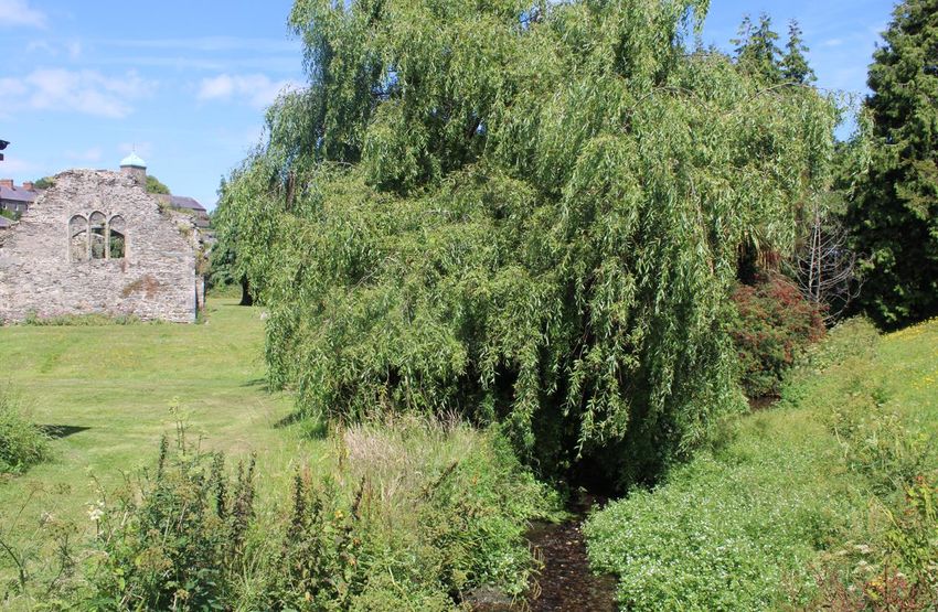
Plate 1: View of Abbey Grounds.
Plate 2: View of Abbey ruins from approximate location of stage area, facing east.
2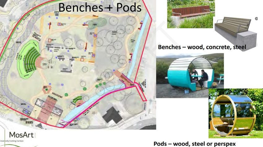
Preliminary Archaeological Impact Assessment Abbey Grounds County Wicklow.

Plate 3: Ashtown Stream facing northeast.

Plate 4: Rear of Coach House where proposed extension will be located.

                                                                             3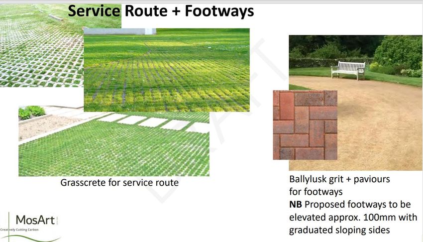
Preliminary Archaeological Impact Assessment Abbey Grounds County Wicklow.
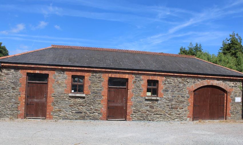
Plate 5: Coach house which will be extended and change of use to café facing northeast.
Plate 6: Entrance at northeast end of the site from the SuperValu carpark.
4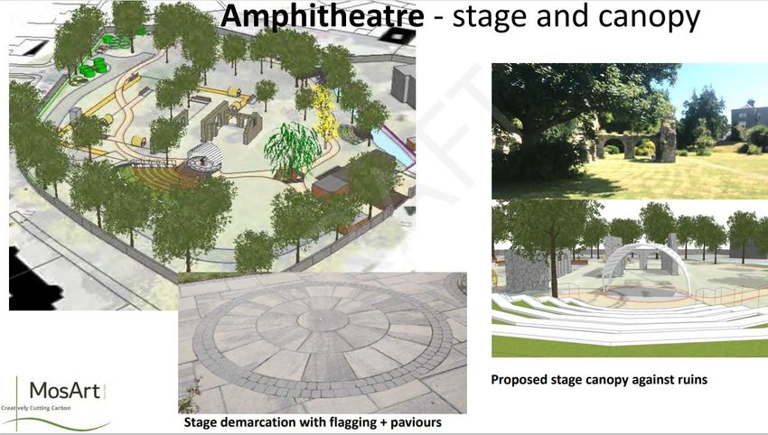
Preliminary Archaeological Impact Assessment Abbey Grounds County Wicklow.

Plate 7: Proposed new entrance at north-east end of park through Supervalu carpark.

3 Description of Development
This project seeks to develop design proposals for the Abbey Grounds incorporating the
public open space surrounding the extant Abbey ruins, and the redevelopment of the former
Coach House (Plates 4 and 5). The aim of the project is to enhance this key open space in
order to maximise its function as a public amenity and a heritage asset. Wicklow County
Council have engaged a multidisciplinary team to prepare high quality design proposals for
Abbey Grounds and to manage the preparation of an application under Part VIII of the
Planning & Development Act for the entire development including a change of use for the
Coach House building to a Café/Retail/Exhibition space and provision of public toilets
(Figure 2-6).

Figure 2: 3-D View of development supplied by MOS Art.

                                                                                      5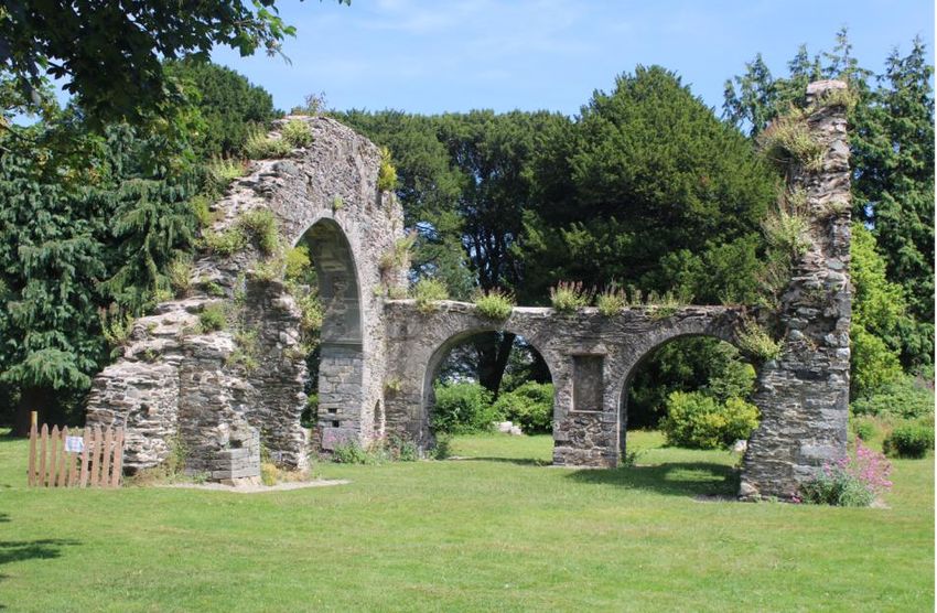
Preliminary Archaeological Impact Assessment Abbey Grounds County Wicklow.

Figure 3: Amphitheatre development plans supplied by MosArt.

Figure 4: Café extension to Coach House.

                                                                             6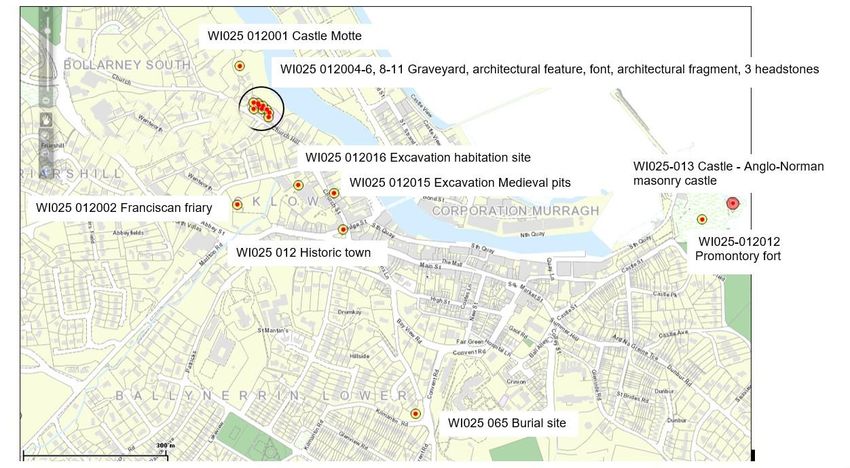
Preliminary Archaeological Impact Assessment Abbey Grounds County Wicklow.

Figure 5: Service route and pathways.

Figure 6: Benches and pods.

4 Legislative Background
This assessment is guided by relevant legislation, standards and guidelines in respect of
archaeology, built and cultural heritage, as follows:
European Legislation
     •    Convention for the Protection of World Cultural and National Heritage, 1972
     •    Council of Europe Convention on the Protection of the Archaeological Heritage of
          Europe, (the 'Granada Convention') ratified by Ireland in 1997

                                                                                             7
Preliminary Archaeological Impact Assessment Abbey Grounds County Wicklow.
• European Convention Concerning the Protection of the Archaeological Heritage (the
'Valetta Convention') ratified by the Republic of Ireland in 1997
National Legislation
• National Monuments Act 1930, amended 1954, 1987, 1994, 2004 and 2014;
• Heritage Act 1995
• Architectural Heritage (National Inventory) and Historic Monuments (Miscellaneous
Provisions) Act 1999
• Planning and Development Act 2000-2018 (as amended).
It is an objective of Wicklow County Council that Wicklow, as the county town, should
become a Tourism Destination Town. This objective is supported by the following plans,
policies and strategies of Wicklow County Council:
• County Wicklow Tourism Strategy and Marketing Plan
• Wicklow County Development Plan 2016 – 2022
• Wicklow Town – Rathnew Development Plan 2013 – 2019
• Wicklow Local Economic & Community Plan 2016 - 2022
• Wicklow Town Public Realm Plan 2008
Figure 7: Extract from published RMP map sheet 25 showing zone of notification for Wickow
Town. The Abbey is located within this notification zone.
5 Receiving Archaeological and Historical Environment
The information contained within this impact assessment has been compiled from various
sources as detailed below and also includes a site visit with MosArt to discuss the
archaeological implications of their proposed development and it was agreed that the
boundary wall which was originally designed to have been removed at certain places to open
up the site would remain intact.
8Preliminary Archaeological Impact Assessment Abbey Grounds County Wicklow.
In summary the cultural heritage constraints have been reviewed within the study area of
Wicklow Town from the following sources:
➢ Archaeological Survey of Ireland including:
Register of National Monuments;
Record of Monuments and Places (RMP);
Sites and Monuments Record (SMR);
➢ Database of Irish Excavation Reports (https://excavations.ie/);
➢ Topographical files of the National Museum of Ireland;
➢ Cartographic analysis;
➢ The Place name Database (Logainm);
➢ Record of Protected Structures for Wicklow Council (WCC).
A number of cultural heritage constraints are located within the study area of the proposed
development. The site of the Franciscan Friary is a Recorded Monument (WI025-012002)
afforded statutory protection under the National Monuments Acts and it is also listed as a
Recorded Protected Structure WTC-RPS24 in the County Development Plan 2021-2027.
The Friary is also within the Zone of Notification for Wicklow Historic Town (RMP WI025-
012----) (Figure 7).
5.1 National Monuments
Under the National Monuments Act 1930 (as amended) and its various amendments
archaeological sites in the ownership or guardianship of the state or a Local Authority and
sites under preservation orders may be designated as National Monuments and offered the
highest level of protection under Irish Legislation.
The site of the Abbey is in the ownership of Wicklow Parish and the proposed works will be
carried out by Wicklow County Council.
5.2 Record of Monuments & Places and Sites & Monuments Record
The RMP is a published list of archaeological monuments and places, generally predating
AD 1700, known to the National Monuments Service of the DHLGH, which receive statutory
protection.
The Sites and Monuments Record (SMR) provides details of documentary sources and field
inspections of recorded sites, and also contains information on potential sites which are not
contained in the RMP but are identified for inclusion to the next published revision of the
RMP.
A summary of RMP constraints within Wicklow Town are listed in Table 1 below 1 (Appendix
3).
The Record of Monuments and Places (RMP) Files and unpublished archaeological
excavations in relation to the proposed development are available at The National
Monuments Service Archive in the Irish Life Centre, Dublin 1 and all monuments were
1Archaeological Survey of Ireland (ASI) descriptions sourced from National Monuments Service’s
Historic Environment Viewer (www.archaeology.ie).
9Preliminary Archaeological Impact Assessment Abbey Grounds County Wicklow.
checked on www.archaeology.ie. The recorded monuments are discussed in the historical
background of this report and are summarised in Table 2 below.
The site is within the archaeological constraint zone for Wicklow Town, WI025-012. Wicklow
town is of Viking origins and has evidence of settlement from the medieval period and
onwards. The prosed works are within the grounds of the Franciscan Friary which is an RMP
site WI025-012002 and subject to statutory protection in the Record of Monuments and
Places, established under section 12 of the National Monuments (Amendment) Act 1994
(Figure 7).
10Preliminary Archaeological Impact Assessment Abbey Grounds County Wicklow.
Reference Legal Status Townland Monument NGR
Number Type
WI025-012 Recorded CORPORATION Historic town 331487/193987
Monument LANDS, GLEBE
(Newcastle By.,
Wicklow Urban ED),
WICKLOW,
BALLYNERRIN
LOWER,
CORPORATION LAND
(1st division)
WI025-012001 Recorded CORPORATION LAND Castle, Motte 331269/194331
Monument (1st division)
WI025-012002 Recorded WICKLOW Franciscan friary 331264/194039
Monument
WI025-012003 Recorded GLEBE (Newcastle Church 331331/194232
Monument By., Wicklow Urban
ED) (Detached portion)
WI025-012004 Recorded WICKLOW Graveyard 331331/194232
Monument
WI025-012005 Recorded GLEBE (Newcastle Architectural 331299/194240
Monument By., Wicklow Urban feature
ED) (Detached portion)
WI025-012006 Recorded GLEBE (Newcastle Font (present 331308/194253
Monument By., Wicklow Urban location)
ED) (Detached portion)
WI025-012008 Recorded GLEBE (Newcastle Architectural 331309/194249
Monument By., Wicklow Urban fragment
ED) (Detached portion)
WI025-012009 Recorded GLEBE (Newcastle Headstone 331316/194240
Monument By., Wicklow Urban
ED) (Detached portion)
WI025-012010 Recorded GLEBE (Newcastle Headstone 331326/194239
Monument By., Wicklow Urban
ED) (Detached portion)
WI025-012011 Recorded GLEBE (Newcastle Headstone 331330/194223
Monument By., Wicklow Urban
ED) (Detached portion)
WI025-012012 Recorded CORPORATION Promontory fort - 332244/194008
Monument LANDS coastal
WI025-013 Recorded CORPORATION Castle - Anglo- 332309/194042
Monument LANDS Norman
masonry castle
Table 1: RMP sites in the vicinity of Wicklow Town.
11Preliminary Archaeological Impact Assessment Abbey Grounds County Wicklow.
Figure 8: RMP sites in Wicklow Town.
WI025-012002
Figure 9: RMP sites and zones of notification within the vicinity of the Abbey grounds site
which is outlined in red.
A total of fourteen Recorded Monuments have been identified within Wicklow Town, a further
two were listed with a precise location unknown; the religious house of the Benedictine nuns
(WI025-0120139) and a Hospital (WI025-012014). Nine of the Recorded Monuments are
associated with the Church of Ireland graveyard (WI025-012004--). These monuments
include headstones, the graveyards, a font, architectural fragments and features. These
sites are discussed in the historical background section of this report.
12Preliminary Archaeological Impact Assessment Abbey Grounds County Wicklow.
5.3 Database of Irish Excavation Reports
A review of the Excavations Bulletin (1970-2007) has revealed that several excavations have
been carried out on Church Hill and Wentworth Place (www.excavations.ie)2.
Four excavations were carried out on Church Hill, none of which yielded anything of
archaeological significance. An excavation for the purpose of relaying a sewer pipe along the
southern side of Church Hill Street, 98E0555 did not expose anything of archaeological
significance. Monitoring undertaken 'The Chestnuts’ Church Hill, 99E0425 did not reveal
anything of archaeological significance. This site was adjacent to St Thomas's Church of
Ireland parish church, which stands on the site of the medieval parish church, WI025-
012003. Testing was carried out for an extension to ‘Johnsville’ villa 98E029 and 1 Milton
Villas, Church Hill, 02E1356 both excavations did not expose anything of archaeological
significance.
A series of archaeological assessments were carried out at Wentworth Place adjacent to the
Abbey, two of which yielded archaeological features. A site assessment by James Eogan
which included test trenches was located at the junction of Wentworth Place and Church
Street, 97E0118. Archaeological features dating to the medieval period which comprised of
rubbish pits and boundary ditches, some of which contained prehistoric scrapers were
subsequently excavated under the same licence. Testing adjacent the above site by Una
Cosgrave, 98E0431, exposed a deposit of archaeological material which lay below modern
disturbance. Monitoring of foundation trenches, which did not impact on the archaeological
deposit was carried out under the same licence. Excavations at ‘The Cottage’ Wentworth
Place 00E0127, was adjacent to excavations carried out on the site of Wentworth House.
The line of one of the boundary ditches from the Wentworth House excavation would have
run through the site at ‘The Cottage’, however, no finds of features of archaeological
significance were exposed (Figure 10).
There
Figurehave been three
10: Excavations excavations
within the vicinity within the grounds
of and within the friary1of
. the friary under the following
licences; 91N0009, 00E0826 and 06E1160 (Figure 10). Testing in advance of a sewer
network upgrade by Carroll which consisted of laying sections of the new culvert and sewer
pipe from the shopping centre carpark entrance on Wentworth Place and into the abbey
grounds involved the excavation of a drain and pit which contained post medieval pottery,
slate and mortar, Licence 06E1160.
2All information on previous excavations in Wicklow Town were obtained from the website
www.excavations.ie
13Preliminary Archaeological Impact Assessment Abbey Grounds County Wicklow.
Medieval pottery and cobbling were exposed during the monitoring of this upgrade and
Three pieces of ornate masonry were found during the excavation for the gabions (stone-
filled baskets) in the Ashtown Stream which originally belonged to the abbey, Licence
06E1160. They were ornate and well worked and very likely to have belonged to the abbey
at some time. An isolated, truncated pit uncovered during construction of the wall on
Woodenbridge Row was the only feature found during the course of the project. The pit
contained pottery of early modern date, but little else that could determine its function.
In 1991 monitoring of the construction of a sewage pipe through the northern and western
parts of the friary uncovered the remains of possibly part of one of the friary buildings along
with sherds of 14th and 15th century pottery. Also uncovered were culverts, gullies and red
brick walls (Curran, 2018). Monitoring of the upgrade works by Tobin however failed to
identify any features of archaeological significance, Licence 00E0826.
The most relevant and significant archaeological survey of the friary was however completed
in 2018 which formed part of a community archaeology research project based upon a
collaboration between Wicklow County Council, Wicklow Tidy Towns and UCD School of
Archaeology. This excellent body of work is crucial to understanding the potential impacts of
the proposed development and accompanies this impact assessment. The survey carried
out sought to identify any sub-surface remains which may point to the existence of the
remaining (parts of) structures and/or activities associated with the recorded monument. The
survey identified a number of probable structures associated with the friary in addition to
several features associated with the later (18th 19th and early 20th century) formal gardens as
illustrated below in Figure 11.
Figure 11: Extract from Figure 13 Geophysical Survey (Curran, 2018).
5.4 Topographical files of the National Museum of Ireland;
The topographical files are held in the National Museum of Ireland in Kildare Street. All files
relating to Wicklow town and the surrounding townlands of Ballynerrin Lower, Ballynerrin,
Ballynerrin Upper, Corporation Lands, Wicklow, Hawkstown Lower, Ashtown, Ballyguile Beg
and Ballyguile More were inspected to ascertain whether any artefacts had been thus far
14Preliminary Archaeological Impact Assessment Abbey Grounds County Wicklow.
recorded in the vicinity of the development. These files identify all recorded finds which are
held in archive and have been donated to the state in accordance with national monuments
legislation.
The finds are discussed in the historical background and outlined in the table below (Table
2).
County Townland Vicinity of Monument Finds Reg. No.:
Wicklow N/A the Black The Black Castle Bronze M 1951:14
Castle Harness
Mount
Wicklow "The Murragh" Wicklow - Irons Sword, S.A. 1909:31
(14 frags.)
Viking
Wicklow N/A Wicklow Town None. Acquired by Stone Axe P.1950:26
vendor at an head
auction, and (ground)
believed to have
come from Wicklow
Town district.
Wicklow Wicklow Town At old ‘sline’ - Wooden 1946:358
bridge, river spade
Leitrim
Wicklow Corporation Black Castle Castle Flint flake 1970:179
Lands (1970:179), +
Medieval
Pottery (Nos.
1970:
174/178).
Wicklow Ballynerrin, parish N. A Cist Cremated P1952:3
Rathnew, Barony bones
Newcastle
Wicklow N/A Within two - Bronze Axe N/A
miles of head
Wicklow Town
Table 2: Topographical Files.
5.5 Cartographic analysis;
Analysis of historic mapping shows the human impact on the landscape and its evolving
nature over clearly defined time intervals. The following maps were consulted in relation to
the proposed development site;
15Preliminary Archaeological Impact Assessment Abbey Grounds County Wicklow.
➢ Down Survey, William Petty, c.1656 Wicklow Scale of 160 perches to 1 inch;
➢ Extract from Jacob Neville’s Map of County Wicklow from 1760;
➢ 1888-1913 Ordnance Survey Map of the Town of Wicklow
➢ Ordnance Survey Map of the Town of Co. Wicklow, sheet XXV.77 1895
Figure 12: Extract from the Down Survey, William Petty, c.1656 Wicklow Scale of 160 perches to 1
inch (downsurvey.tcd.ie).
At the time of the Down Survey Map Wicklow is depicted along with the River Leitrim and at
least one church. Several other buildings are also illustrated (12). There is no obvious
depiction of the Abbey.
Figure 13: Extract from Jacob Neville’s Map of County Wicklow from 1760.
In 1760 Wicklow Town is depicted along with the River Leitrim, the Black Castle and three
churches (Figure 13). The church-on-church hill is also depicted and appears to be the
largest of all those illustrated. The Abbey appears to be depicted as does a circle which
encloses a cross to the northwest of the possible friary building.
16Preliminary Archaeological Impact Assessment Abbey Grounds County Wicklow.
Figure 14: First edition ordnance survey map with site outline marked in blue c.1838 (source
www.archaeology.ie).
At the time of the first edition map the Abbey is depicted as ‘in ruins and within a landscaped
park. There is a small ‘L-shaped’ building on at the southwest end of the site on Abbey Hill,
although there is no trace of this building today. A pathway is depicted skirting around the
ruins of the Abbey. The site is located in the townland of Wicklow which is situated within the
Civil Parish of Rathnew and the Barony of Newcastle. The southern part of the site is also a
parish and barony boundary between Rathnew and Drumkay (parish) and barony boundary
between Newcastle and Arklow. These boundaries may preserve much earlier land
divisions.
Figure 15: Ordnance Survey Map of the Town of Co. Wicklow, sheet XXV.77 1895 (source
//digital.ucd.ie/view/ucdlib:41681)
17Preliminary Archaeological Impact Assessment Abbey Grounds County Wicklow.
Figure 16: 1888-1913 Ordnance Survey Map of the Town of Wicklow (Curran, 2018).
A small building is positioned in the south western corner on the 1888-1913 and 1895 maps,
this was not depicted on the first edition map. There is no visible trace of this building today
and it is possible that the bin storage area may be located in the vicinity of this building. A
second unnamed rectangular structure is depicted on the 25inch map and 6inch maps,
located between the lodge and the abbey (which is now the parochial house) and oriented
north west to south east, which is still visible today. The free-standing 'stump' of masonry
which lies to the north of the ruins of the Abbey is depicted on all historic mapping. Gardens
and pathways follow the circuit of the enclosing walls Stream in the north east quadrant of
the grounds. A glasshouse structure (approx. 6m x 4m) is depicted on both the 1895 and
25inch maps - and was confirmed by a photograph taken by Robert French in the late
19th/early 20th century; this structure is no longer upstanding but an area of overgrown
shrubbery and briars appears to mark its original location (Curran, 2018).
5.6 Place name Analysis
There are a number of sources available for place name analysis, O’ Donovan, Curry and O’
Conor were the Ordnance Surveyors who recorded the townland names of Wicklow. Other
sources used include Joyce’s Irish Local Names Explained (1870) and the website
Logainm.ie. Liam Price however provides the main source of information. The Place-Names
of County Wicklow Part VII the Baronies of Newcastle and Arklow and also his notebooks
which records antiquities, folklore and place names are an invaluable source of information
(Corlett & Weaver, 2002). Other sources consulted include John Colgan’s Acta sanctorum
Hibernia, The Lives of the Saints by O Hanlon and the Ancient Churches in the Deanery of
Wicklow by Ronan 1928.
Place names are an invaluable source of information as they may record a forgotten history
or a long-forgotten site which may still survive below the surface of the ground. This is
especially true in
18Preliminary Archaeological Impact Assessment Abbey Grounds County Wicklow.
Wicklow and Cill Mantáin are not the same place- although the Irish version of the name is
used in modern times for Wicklow. Price notes that this place may have been a cell built by a
hermit before ever the Norse came to Wicklow. the case of Wicklow town as will be
discussed in the following paragraphs.
The site is located in the townland of Wicklow which is situated within the Civil Parish of
Rathnew and the Barony of Newcastle. The southern part of the site is also a parish and
barony boundary between Rathnew and Drumkay (parish) and barony boundary between
Newcastle and Arklow.
Cellmantan, Kilmantin, Wicklow
Curry notes that the name Wicklow has puzzled many antiquarians and that it was not the
original name for Wicklow (Corlett & Medleycott, p. 87, 2000,). It was once called Killmantan
by Irish speakers but a date when it became known by this name is not certain. Curry
translates it as church or ‘Cell of Mantan’, which means toothless person. According to Price
there is a reference to a Mantan in the Annals of Clonmacnoise which he believes is an
untrue story. The Annals record that Cill Mhantáin derives its name from a man who was
made toothless after he was struck in the mouth by another man who opposed St Patrick’s
landing in Wicklow (Price L., p. xv, 1967). He states that this is as an obvious invention to
account for the name Cill Mhantáin, furthermore the eight century manuscripts associate St
Patrick with Kildare, not Wicklow (ibid.).
Price notes that there is not much to be said about the history of County Wicklow until the
sixth century (ibid.). Cuala which was ruled by the Ui Theig Tribe was an early name for the
area which included the Dublin and Wicklow Mountains (Corlett, p. 34 1999, Price, p.vii
1967). Wicklow was known as Hostium Dee, the Mouth of the Dee in the Book of Armagh,
the Annals of the Four Masters call it Inbhear Dea in 835 (Ronan, p. 141, 1928). It derived its
name from the River Deadha, which flowed through the territory of a tribe called the Ui
Deadha, the river is today known as the Vartry River. According to Price as discussed
previously Kilmantin was on the ‘other side of the Marlton river’ and he notes that this may
have been a cell built by a hermit before ever the Norse came to Wicklow (Price, 1945).
Ronan’s reference discussed below to a church Cellmantan in 1179 A.D. supports Price’s
theory. It is possible that the burials at Weston Close are associated with this early
foundation.
Price defines Wicklow as meaning ‘the water meadow of the Vikings’ and between 835 A.D.
and 1185 A.D. it became known as Wykinglo by the Danes and Wyklo by the English
according to Cambrensis (ibid).
Logainm gives the Irish for Wicklow as Cill Mhantáin. The website also contains
documentation from the archives of the Placenames Branch. It contains information in the
form of scanned handwritten notes from various sources. It notes that Wicklow is a Danish
name, in Irish is Cill Mantáin i.e. Mantans Church.
Joyce gives the name Wickow as Danish in origin with old forms of the name being,
Wkyynglo, Wygyngelo, Wykinlo. He gives the old Irish name as Kilmantan, the church of St.
Mantan. He like Curry references the Annals of Clonmacnoise stating that Mantan was one
of St. Patrick's disciples who had his front teeth knocked out by the blow of a stone thrown
from a ‘barbarian’ was opposed to St. Patrick’s landing. This disciple was given the name
Mantan meaning toothless one.
Ronan recounts another similar but different story to Curry which Price rejects as to the
origins of Kilmantan, it was a disciple of St Patrick who accompanied him on his landing at
the mouth of the Vartry River. He was called Mantan as in Irish this means gapped teeth.
Mantan appears to have accompanied St Patrick on his travels however was disobedient
and St Patrick predicted that the church of Mantan should be humble and of moderate
19Preliminary Archaeological Impact Assessment Abbey Grounds County Wicklow.
dimensions (O'Hanlon & Joly, p. 83, 1821 -1905). According to Ronan two ancient writings
give an account on the life of Mantan; the Viita Tripar and Jocelyn’s Life.
Wicklow town has a rich archaeological heritage stretching back from early medieval times
right up until the later medieval period. Evidence of early prehistoric activity in Wicklow
however is scarce, and there are several explanations for this.
In Kings, Saints and Saga, Smyth argues that the Wicklow Mountains, especially the coastal
strip stretching from Bray down to Arklow and further south was a political backwater in early
Ireland. This could be explained by the poor accessibility of the area as it was cut off from
the richer Irish interior by the surrounding mountain chains, it was poorly drained and very
heavily forested. Its rivers ran west to east from the mountains to the sea, obstructing the
path of travellers striving to move up or down the coastal hinterland (Smyth 1994). The
following sections will discuss Wicklow town in terms of the archaeological periods in an
attempt to illustrate the rich and varied archaeological and maritime heritage of the town
Prehistoric Period (7,000BC to 400AD)
Mesolithic activity (7,000- 4000 BC) in Wicklow is primarily confined to a 4km coastal strip
which extended east from Seabank near Arklow to Clommannon 5km north of Wicklow town.
An explanation for this could be that the majority of this activity would have taken place in
the coastal areas which are now submersed by and washed away by the sea through
erosion (Stout 1994, p.4; Corlett 1999, p.11).
Coastal locations were important for Mesolithic communities and boats would have been an
essential means of travel for them. There is very little evidence for boats from this period
from Ireland however many dug out boats have been uncovered in Europe (Brady, 2008). In
more recent years Mesolithic fish traps have been uncovered in Dublin’s Docklands and
represent a more sophisticated method of fishing that was previously thought and may have
been a common sight in Mesolithic Ireland around bays and river estuaries during this era
(ibid.).
One kilometre southeast of Wicklow Harbour there is evidence of later Mesolithic activity
from a cave at St Bride’s Head which was discovered by Charles Martin in 1932, WI025-039.
The cave floor contained broken flints and flint pebbles (Stout 1994). Mitchell spurred on by
the findings in 1932 revisited the coast around Wicklow and found Mesolithic tools on the
coast just south of Wicklow town and also at Brittas Bay just north of Arklow. At the latter
location he found a large scatter of flint debris near a stream which included scrapers,
blades and rough outs (ibid 5).
The earliest evidence for settlement and movement through the west Wicklow mountains
dates to the Neolithic period (c.4000-2500 BC), the period of the first farming communities in
Ireland. Neolithic passage tombs, burial places of the ancestors and ritual markers of
prehistoric territories are found along the western edges of the Wicklow Mountains and on
particular summits and hills. Today passage tombs are visible as distinctive cairns (Grogan
& Kilfeather 1997, p.3). A stone axe head which would date to this era was found in Wicklow
Town (NMI Ref: P 1950:26). These axes would have been used in the construction of dug -
out canoes and perhaps more robust sea going vessels which would have exported
porcellanite stone axes from Antrim as far as England (Brady, 2008, p.17).
It is in the Bronze Age (2500 – 600 BC) that more substantial settlement patterns emerged.
Newly discovered archaeological sites, uncovered as a result of the construction of the N11
Rathnew to Arklow road scheme uncovered sixty-six sites, the majority of which were burnt
mound sites. They are typically located near a stream or in marshy ground and comprise a
crescent-shaped mound made up of small pieces of shattered stone (Stout 1994). The
excavations of the church and burial site at Drumkay northwest of the town uncovered
evidence for earlier occupation which centred on a circular hut site at the southeast corner of
20Preliminary Archaeological Impact Assessment Abbey Grounds County Wicklow.
the burial site and enclosing ditches. Flint artefacts dated this site to the Bronze Age
(O’Donovan, 2006).
In the Early Bronze Age, the dead were placed in cist burials comprised of a usually
rectangular structure either constructed either below surface in a pit form or above the
surface. The edges were lined with stone slabs covered by one or more capstones, often the
dead were accompanied by grave goods such as pottery vessels.
An example of a cist burial of an Early Bronze Age date can be seen in Ballynerrin, WI025-
014. The cist was aligned east-west on a gentle south facing slope of a low flat-topped
hillock.
Cremation pits another burial style from this era generally date from c. 2400-500 B.C. and
comprise of a pit containing the cremated remains of an individual occasionally accompanied
by grave goods. A single cremation pit was excavated by the author in 2013 in the townland
of Knockrobin approximately 1.5km northwest of Wicklow Town. The excavation of the
church and burial site at Drumkay, prior to the excavation of the Port Road uncovered
evidence for earlier occupation which centred on a circular hut site. Flint artefacts dated this
site to the Bronze Age.
There is evidence during the Bronze Age of increased contact with Europe and this would
have been enabled through the new tools and technology which enabled more robust boats
to be built. The earliest evidence outside Ireland is boats that were plank built and were
sewn together (Brady, 2008). The tradition of dug out boats did however continue in Ireland
and a fine example is the Lurgan boat which was hollowed out from an oak tree. Wicklow
was linked with the Isle of man, Pembrokeshire, Cornwall and Argyll (ibid. p19). Wicklow
gold and Avoca copper would have made Wicklow an important town during this era.
Early Medieval Period (500- 1150 A.D.)
The medieval period in Ireland began around 500 A.D. This was a time of massive social
change with the arrival of Christianity the new and soon to be dominant religion and the
development of new political dynasties. At the Iron Age/ early medieval transition Ireland was
made up of up to 150 tuatha or tribal units/ petty ruled over by a chief or king. In turn these
tribal units formed part of larger territorial units ruled over by over Kings.
In the sixth/seventh century Wicklow was ruled by the Dál Messin Corb a leading Leinster
dynasty of whom St Kevin of Glendalough was a member. This tribe was later taken over by
the Uí Mail who rose to power as the Kings of Leinster having killed Maelodran, a legendary
hero of the Dál Messin Corb tribe (Smyth 1994, p.48, Corlett 1999, p.35).
Little is known about the early history of the Irish church. By the first half of the 5th century
A.D. there was a significant Christian community living in Ireland. In the year 431 A.D the
bishop Palladius was sent by Pope Celestine to the “Christians in Ireland” (Edwards, p.99,
1990, Charles-Edwards p.182, 2000). The late fifth century saw the beginnings of extensive
missionary activity in Ireland. St Patrick is the best known of the early missionaries.
Archaeological evidence for early medieval Christianity includes cemeteries, hermitages,
and pastoral church sites along with large and small monasteries. Burial in Irish monastic
cemeteries was reserved for higher ranking members in society up until the 8th century.
Prior to this the general population were buried in what has been termed familial burial
grounds which would have contained both pagan and Christian burials. By the early 8th
century, the church began to legislate with regard to acceptable burial practices for
Christians. As monastic centres became more predominant the use of familial cemeteries
discontinued as the Church encouraged communities to bury their dead in consecrated
ground.
There is significant evidence for early medieval Christianity in Wicklow Town and in 2013 the
author completed an assessment for a site at Weston Close which may be Cellmantan, first
21Preliminary Archaeological Impact Assessment Abbey Grounds County Wicklow.
noted in 1179 A.D. A total of ten burials were identified in the southeast corner of a roughly
‘D’ shaped enclosure on the ridge of a natural hill.
A previous assessment in 1990 by Scally at Weston Close uncovered Leinster Cooking
ware, which broadly dates from the mid-12th to the 14th centuries. A decorated medieval tile
of 16th century date was also uncovered. This indicates that the site may have been in use
over a period of time.
Other evidence for early medieval activity in the environs is at the Church site of Drumkay in
Glebe townland, WI025-011001 which is approximately 1.5km northwest of Wicklow town.
The excavations in advance of the Wicklow Post Access Road uncovered a church and
cemetery site which contained 191 burials all enclosed within a series of ditches, the burials
which dated to three phases date from 600-1100 A.D up until 1600 A.D. The earliest burial
pre dated the church, the foundations of which were also exposed during the excavations.
This ecclesiastical site is thought be associated with a St Bercham (O Donovan E., p.9,
2006).
The townland boundary between Glebe and Knockrobin was excavated by the author in
2013. The bulk of the features exposed during the excavation in 2013 were related to
medieval industrious activity, for example four kilns and associated features were excavated
and recorded. It is not uncommon for this type of activity to be located at the periphery of
medieval graveyards and ecclesiastical sites.
Across the road from the school is the protestant parish church which is said to be of
seventeenth century in date. It is a single aisled building with a west tower. There are
several medieval architectural fragments in this church; a romanesque doorway of uncertain
provenance however Corlett suggests it may have come from an earlier church that may be
located within the graveyard of the present church (RMP Files). The remains of a fifteenth
century church were noted during gravedigging at the north side of the graveyard according
to the RMP files. There are a number of 17th century headstones in this graveyard.
There is certainly a great deal of early medieval activity in Wicklow Town and during this
period easy access to the Irish Sea would have been increased maritime activity. There are
many historical references to the boats used by the saints to convert the pagan Irish and
boats are depicted on the high crosses. They appear to represent the Scandinavian style
longboats (Brady, 2008, p.26)
Later Medieval Period (1150-1700 A.D.)
From 795 A.D. the Norse raiders or Vikings began raiding the east coast of Ireland and
founded their first base at Dublin. From there they plundered the countryside especially
targeting the monasteries which held great wealth. The invaders secured rivers by
establishing bases at its mouths and from there they could penetrate inland (Flynn p. 14,
2003).
Etchingham notes that the beginnings of Viking activity in Wicklow by 827 A.D. are quiet well
documented (p.113, 1994). The name, Wicklow as has been discussed above derives from
the Scandinavian either Vikingalo, ‘meadow of the Vikings’ or Vik-lo ‘meadow of the bay,
(Grogan and Kilfeather, p.177, 1994). Price defines Wicklow as meaning ‘the water meadow
of the Vikings’ and between 835 A.D. and 1185 A.D. it became known as Wykinglo by the
Danes and Wyklo by the English according to Cambrensis (ibid).
The first hint of a permanent Viking settlement in Ireland was at ‘Inber Dea’ somewhere in
Wicklow which was identified in the Annals. It was from this location that the pagans
attacked Kildare. Raids undertaken by the Inber Dee Norsemen referenced in the annals
include a raid on Glendalough in 834 A.D., Ferns in 835 A.D., Glendalough again in 836 A.D.
and Ferns again in 839 A.D. There was also an attack on Clonmore in 835 A.D. and in 836
A.D. on Christmas Eve, which indicates that the Norsemen must have overwintered in
Wicklow. By 836 A.D. the Norsemen had established themselves on the Wicklow coast line.
22Preliminary Archaeological Impact Assessment Abbey Grounds County Wicklow.
The locations suggested are Wicklow, Bray and Arklow, however the latter is the preferred
location for this settlement.
Two finds from the vicinity of Wicklow Town are indicators of settlement, iron sword
fragments from the low-lying coastal area, The Murrough in the north of Wicklow Town (Reg
S.A 1909:31) and a pair of brooches and silver chain (NMI Ref: 1901:50-52) from
Threemilewater near Arklow. Both finds were made in the late 19th century so the find spots
are not exact. The sword belongs to a group of highly decorated swords probably
manufactured in southern Scandinavia in 9th century (NMI Topographical Files). Whist only
fragments of the sword have survived it is possible that this sword may have been
deliberately bent or broken as part of the burial practice as was the case at Kilmainham and
Islandbridge (Etchingham, 1994).
The pair of brooches and silver chain was handed into the museum after passing through
two or three hands and was supposedly found between Threemilewater and Arklow. The
brooches are a well-known Scandinavian tortoise brooch, Norwegian type 51 as classified by
Jan Petersen and date to late 9th or early 10th century (O Floinn, Topographical Files NMI).
They are believed to constitute part of the grave goods of a female of Scandinavian birth and
are indicative of settlement.
A further indication of settlement in Wicklow Town is the Round Mount (WI025-012001). This
steep sided mound is situated on high overlooking the Leitrim River at the north end of
Wicklow town. This steep-sided mound 6-7m in height has been dug into at its southeast
side and is very overgrown with trees and briars (Grogan and Kilfeather, p.177). This site
appears to be the site of the ‘castellum’ which was granted to Strongbow by Henry II in 1173
(Grogan and Kilfeather 177, Etchingham p.118). This may indicate that there was a pre-
Norman settlement at the site. Price believes that this mound represents a Scandinavian
assembly mound (Etchingham, p.118).
Glendalough during this era was one of the most important monasteries in Ireland and
possessed great wealth and was surrounded by great deciduous forests which provided fuel
and timber for the Vikings houses and ships. The Vikings were skilled sea farers and their
ships were light, fast and clinker built. Excavations in Dublin, Waterford and Wexford along
with art work representations have given a good understanding of their ships (Brady, 2008).
The Skuldelev 2 which was deliberately sunk in a fjord in Denmark appears to have been
built in either Wicklow or Dublin in 1042 (ibid.). The Sea Stallion of Glendalough longship is a
replica of the Skuldelev 2 which was built in 1042 and it was sailed from Roskilde to Dublin
in 2007 in order to experience how swiftly and far the Vikings could travel in their ships.
By the end of the twelfth century the Vikings were met with a new political and social force
as the Anglo Normans invaded Ireland. The Anglo-Norman invasion was the result of a
vendetta between Dermot and Tiarnán O’Ruairc of Bréifne. In 1152 A.D. Mac Murrough
abducted O’Ruairc’s wife and held her hostage for a year. O’Ruairc formed alliances with
Mac Murroughs enemies and in 1166 A.D. banished him from Ferns. As a result of this Mac
Murrough who realized his lands were in danger requested Henry II’s help in reclaiming his
lands. Mac Murrough travelled through England and Wales gathering forces including
Strongbow who pledged his assistance on a number of conditions; that he would be King of
Leinster when Mac Murrough died and that he could have Aoife, Mac Murroughs daughter.
The invasion began in 1167 A.D. when a small troop of Anglo-Norman forces along with Mac
Morough landed in Bannow Bay. In 1169 A.D. further troops arrived and they set out to take
Dublin. The High King Ruairi O’Conchúir did not anticipate the route Mac Murrough would
take through the mountains and the Anglo Normans took Dublin within a few days. Henry II
granted most of the land in Leinster to Strongbow but retained a narrow strip from Wicklow
to Arklow himself.
In the initial decades after the Norman invasion in 1169 A.D., a distinctive type of earth and
timber fortification - the motte and bailey - was built. The more substantial stone castles
23Preliminary Archaeological Impact Assessment Abbey Grounds County Wicklow.
followed in the 13th and 14th centuries. Less elaborate tower houses, the fortified residence
of the aristocracy (both old Norman and Gaelic), were erected in the 15th to early 17th
centuries A.D. The Anglo-Normans were an important influence in the creation of an urban
network in medieval Ireland.
Anglo-Norman activity in the environs of Wicklow town is represented by Black Castle which
is just south of Wicklow Harbour on a rocky promontory. It is separated from the land at its
west by a deep rock cut fosse and the sea on all other sides. Today only the foundations
survive along with its south wall (Grogan and Kilfeather 1994, p.181). Black Castle was
probably built in the 13th century as part of a coastal defence which stretched from Bray to
Arklow (Simpson 1994, p.213). In 1229 the castle was in Geraldine hands but by 1339 it was
held by a royal constable with a garrison of soldiers.
The earliest wreck recorded in this study area relates to an attack on the Black Castle in
1355 where a boat which was laden with many foot soldiers and archers sunk after a strong
wind blew it onto the rocks below the Black Castle. The attack was led by Thomas Talbot,
Lord of Malahide on his Irish enemies which were encamped near the Black Castle (Brady,
2008).
The O’Byrne’s seized the castle in 1370 and it was rebuilt by a William Fitzwilliam with the
addition of three towers, two of which were over 30ft high. By the end of the 15th century the
castle is recorded as being in disrepair (ibid 214). A bronze harness mount from Black
Castle is recorded in the National Museums Topographical Files (Reg M1951:14).
The twelfth century also saw the introduction of continental monastic orders with the Anglo-
Norman lords setting up religious centres in their new lands (Grogan and Kilfeather 1994,
147). Wicklow had become a place of importance during this era as evidenced by the
building of a new church and Franciscan Friary. The new church was built under the
patronage of the Fitzgerald’s, presumably the present-day Church of Ireland Church on
Church Hill (Ronan, p.143, 1928).
The elaborately carved door arch which is compared to a similar one at St Saviour’s Church
in Glendalough (Leask, p., 160-161, 1955-1960). This arch which dates to the 12th century
coupled with the limestone font may indicate that the present church stands on the site of an
earlier church of which these were features.
The Franciscan Friary was also built in Wicklow during this era by the O’Toole’s and the
O’Byrne’s in 1279 A. D, in gratitude for a victory gained over the Fitzgerald’s (Ronan, p.134,
1928). The Friary is first referred to in 1325. The north wall of the nave (h c.6m) and parts of
the southern transept of is all that survives today, it is constructed of uncoursed slaty
limestone (Plates 1 and 2). The S wall of the transept has a round-headed three-light
window, with traces of sandstone jambs. The nave has a large inserted arch, and the only
original feature is part of a window splay at the E end.3
There are only a handful of references to activity at the site in the subsequent centuries,
such as the fire of AD 1301 which damaged the friary as well as the Black Castle (Finlay
2013, 34).
There is a reference to a Benedictine Convent (RMP WI025-012013) having existed in
Wicklow Town from 1448 to 1470 A.D. and also the existence of a leper hospital 1578 A.D.
(RMP WI025-012014) (Emerald, p. 10, 1998-1999).
The Anglo Normans also brought new ships to Ireland in the form of galleys, cogs, hulks,
and barges. Wooden and stone quay fronts facilitated the expansion of ports, however there
has not been a complete vessel found from this era to date. The ships were used to
transport goods and the cog and hulk type were important merchant vessels in that they
3 Sites and Monuments Record (www.archaeology.ie).
24Preliminary Archaeological Impact Assessment Abbey Grounds County Wicklow.
could also be used as war ships (Brady, 2008, p.31). Fish was the most important export
during this era and brought significant taxes to the Anglo Normans who established Castles
at major ports in the country including Black Castle in Wicklow discussed above (ibid. p. 32).
By the 14th century A.D. England was engaged in wars with France and Scotland and its
resources were heavily stretched. As a result, King Edward II withdrew most of his army
from Wicklow. The Norman settlers were attacked frequently and withdrew into the Pale for
protection (Stout, 1998).
In 1534 the suppression of the monasteries was enacted by Henry VIII and the allegiance of
the Irish clans was sought through Henry’s ‘surrender and regrant’ policy (Emerald, 1998-
1999, p. 7). In 1541 Henry was declared King of Ireland and various clans including the O’
Byrne Clan submitted to his rule. The plan was that Wicklow would be shired, however this
did not materialise for many years.
The friary and its lands were seized in AD1552 as part of the suppression of the
monasteries. The following paragraph is an extract from the geophysical survey report
completed and which provides a detailed history of the site:
‘At the time it was seized, its lands consisted of 9 acres of arable land and 1 acre of
meadow (Archdall 1786, 778; Clarke 1943, 11), possibly including the area known as 'Friar's
Hilt' (Clarke 1943, 13) which is situated to the west of the friary site, and potentially
extending into the 'Glebe' townland which adjoins it. The land was then leased to various
tenants (loyal to the Crown) who used it for various secular purposes, for example as an
arsenal during the Rebellion of AD 1641 (Finlay 2013, 35), and as a courthouse and a gaol
during the 17th and possibly early 18th centuries (ibid). It is unclear whether the original
structures or buildings were used and/or were modified in any way, although the red brick
building remains and wall foundations uncovered during the 1991 excavations (see below),
would suggest that additional structures were present around this time.
The friary and grounds finally returned to the ownership of the clergy in AD 1799 when they
were granted to Fr. Andrew OToole by the Earl Fitzwilliam (Finlay 2013, 112-115). The last
secular tenant was a Catherine Eaton (death recorded in 1795) who resided in a house on
the site of what is now the parochial house - the original house was destroyed by fire in ADI
799 (Finlay 2013, 114). Catherine Eaton was the last of the Eaton family, and no doubt a
relation of the Mrs. Eaton who strove to maintain the friary ruins and gardens (Archdall 1786,
778). The gardens were defined as a 'pleasure garden' by Beranger and Barralet during their
1780 sketching tour, describing it as being "laid out in walks, lawns and flower beds"
(Harbison 2004, 1 85); although images of the site around this time do not depict the formal
gardens (Plates 7 & 8). Wright (1822, 61) describes the grounds as a "gentleman's garden",
also attributing their maintenance to Mrs Eaton. However, late 19th century photographs
(Plates 9 & 10) of the site depict well-planted, formal gardens, complete with pathways which
seem to corroborate the 1895 mapping (and the geophysical survey results) (Curran, 2018).
Wicklow Town was believed to have come to prominence again in the late 16th and early
17th centuries A.D. (Bradley and King, p.68, 1989). Earthwork ramparts are recorded as
being constructed around Wicklow in 1576 (ibid p.94).
In 1606 A.D. Wicklow was eventually created a county. Coinciding with the shiring of the
county the Church of Ireland sought to extend its control over the county and a general
visitation of Ireland was commissioned to report on the state of the Protestant Established
churches. Richard Bermingham was the vicar of Wicklow and the church was noted as in
good or ‘bene’ condition (Emerald, p. 18, 1998-1999).
A further visitation by Archbishop Bulkeley’s in 1630 A.D. showed that there was still strife in
Wicklow and that the Protestant Established churches were failing to get a firm foothold in
the county. The protestant church in Wicklow which was previously in good condition was
now covered but, not decent, within. There was also the record that Balthazar Fox, the vicar
25You can also read