A SUCCESSFUL FAILURE - NOT APOLLO 13, A DAM INCIDENT AT SUGAR CREEK SITE L-44 - NOT APOLLO 13, A DAM INCIDENT ...
←
→
Page content transcription
If your browser does not render page correctly, please read the page content below
A SUCCESSFUL FAILURE – NOT APOLLO 13, A DAM INCIDENT
                 AT SUGAR CREEK SITE L-44.

           J. Chris Stoner, Oklahoma NRCS, State Conservation Engineer
     Robert Toole, Oklahoma Conservation Commission, Director of Conservation
                                    Operations

For Paper and Poster Presentation at the Dam Safety 2008 ASDSO Annual Conference
                                  Indian Wells, CA
                                  September 2008

                                        Abstract
       This paper will detail the response to the near failure of the Flood Water
Retarding Structure in Caddo County, Oklahoma known as Sugar Creek L-44. In
addition, the paper will outline lessons learned from the event and plans for the future.
A subsequent paper is being proposed that will detail the technical aspects of this
incident.

       August 18-19, 2007 the remnants of Tropical Storm Erin re-intensified over
southwest Oklahoma producing rainfall amounts exceeding the 100-year storm event.
Flow in the auxiliary spillway breached an asphalt road downstream of the dam and
attacked the back toe of the dam, eroding a portion of the dam through the centerline.
Floodwaters from the breached roadway flooded one house downstream and a possible
dam breach threatened several others.

       Caddo County Emergency Management, the South Caddo Conservation District
(sponsor of the dam), the Oklahoma Conservation Commission, the Oklahoma Water
Resources Board, the Natural Resources Conservation Service and others worked in
tandem to avert a catastrophe and potential loss of life. Their efforts resulted in
evacuations, protection of downstream structures, major modifications to the dam, and
ultimately removal of the hazard by lowering the dam crest as the water level in the pool
dropped. This modification to the dam, which reduced the potential hazard, will remain
in place until the site is rehabilitated.

Key Words: Failure, EAP, ICS, auxiliary spillway flow, rehabilitation

                                         Page 1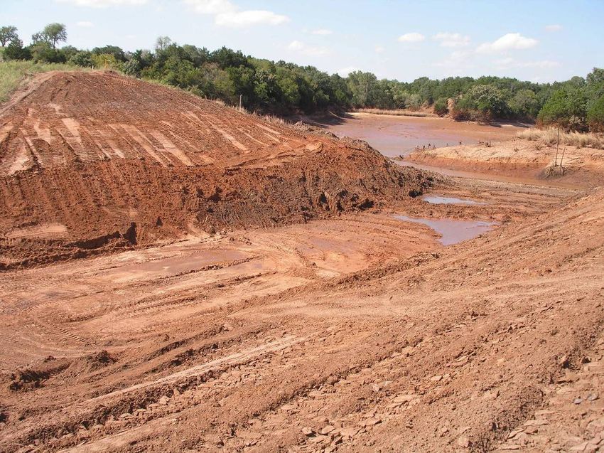
The Event
Late on the night of Saturday August 18, 2007 and continuing through the early
morning hours of Sunday August 19, 2007, the remnants of Tropical Storm Erin re-
intensified over southwestern Oklahoma. Reports of more than 13 inches of rain were
reported in this part of the state. It is estimated from River Forecast Center data that
Sugar Creek Site L-44 received 8.31 inches. This is just below the 100 year-24 hour
storm event of 8.6 inches. However, witnesses reported that the storm duration was
between 6 and 7 hours which results in a near 500 year-6 hour storm (8.8 inches).
Flow in the auxiliary spillway, estimated between 2.6 to 3.6 feet, breached an
asphalt road downstream of the dam. Floodwaters from the breached roadway flooded
one house downstream and a possible dam breach threatened several others.
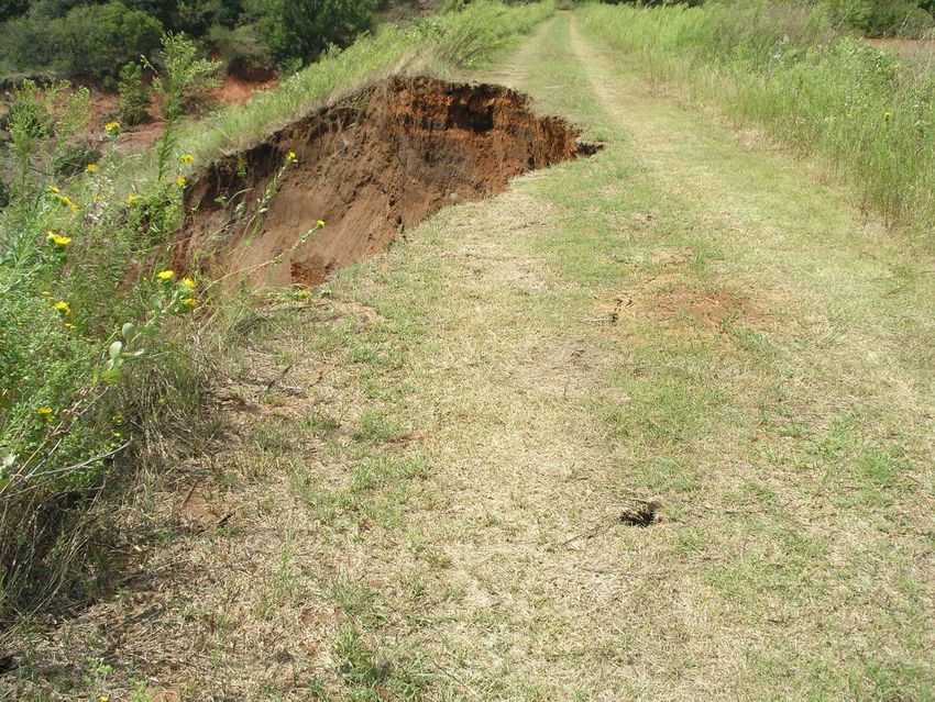
The topsoil in the auxiliary spillway (AS) was eroded away down to sandstone
rock. The rock is situated such that water is forced toward the dam. The AS berm
breached, allowing water to flow down the back side of the dam causing a void and
sloughing. This caused the backtoe of the dam to erode which progressed through the
dam centerline.
The eroded embankment continued to collapse towards the upstream crest of the
top of the dam. By the evening of August 22, the eroded area was within 4 to 5 feet of
the upstream crest of the dam. Oklahoma NRCS and Agricultural Research Service
Page 2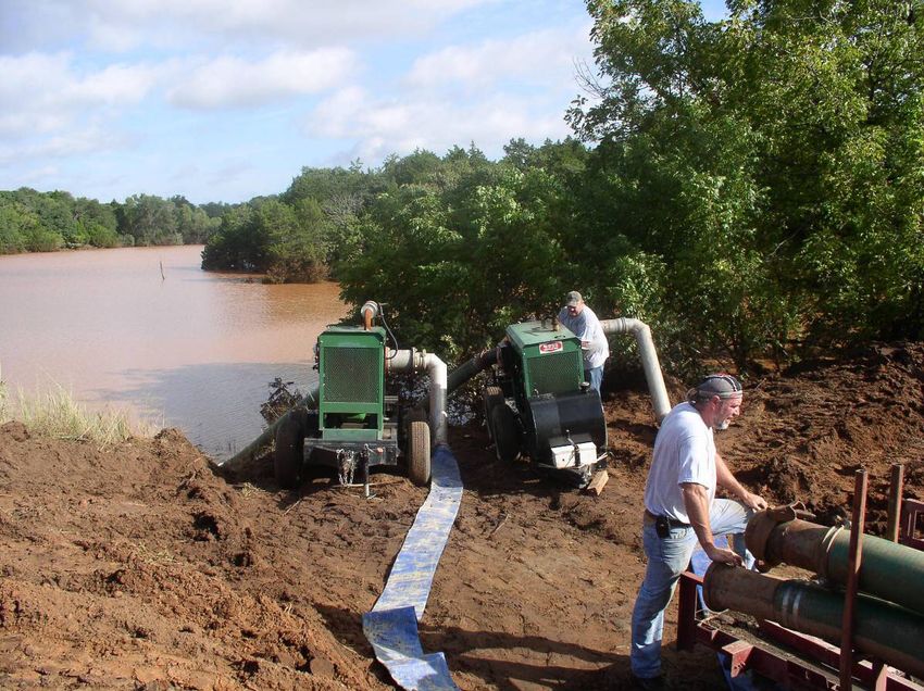
(ARS) Hydraulic Engineering Unit personnel had discussed a possible “controlled
breach” and where to locate a breach in the dam to lower the water level and reduce the
risk of inundation of downstream homes. A manufactured breach in the dam was
planned near the right abutment due to the presence of competent sandstone in the
abutment, but this breach was not performed.

       The site is a high hazard earthen embankment of intermediate size with a fill
height of 64 feet built in 1971 under the authority of the PL-566 Small Flood Control
Program administered by the Natural Resources Conservation Service and sponsored
by the South Caddo Conservation District and the Oklahoma Conservation
Commission. It has a drainage area of 1709 acres and a pool area of 17 acres storing
721 acre feet of water at the auxiliary spillway crest. This was the second reported
time for the auxiliary spillway to flow.

                                  The Response
       The emergency action plan was activated on the morning of August 19 by the
South Caddo Conservation District and Natural Resources Conservation Service to
ensure the safety of those downstream in case the dam was to fail. Caddo County
Emergency Management Director and the Caddo County Sheriff began the evacuation
process. All residents below the dam in the breach inundation area were evacuated.
The site was monitored throughout the day Sunday (August 19).

        The situation showed no signs of improvement by Monday morning. The NRCS
District Conservationist contacted the NRCS State Conservation Engineer, to inform

                                        Page 3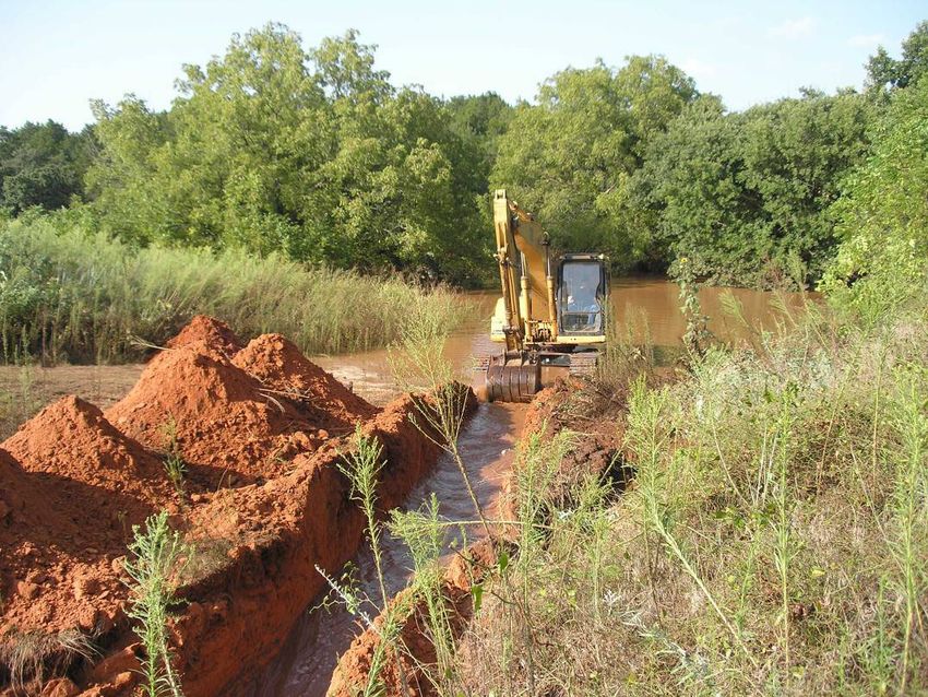
him of the situation at the site and to report other auxiliary spillway flows from sites in
Caddo County. The District Conservationist was very concerned about the stability of
Site L-44 and requested assistance. The NRCS State Conservation Engineer asked
the District Conservationist to take photographs of the site to help determine a course of
action. The District Conservationist had already taken photographs but had to go back
to the office to download and send.

       Photographs were received from District Conservationist at 10:54AM. The
NRCS State Conservation Engineer then contacted the Project Engineer, Pauls Valley,
Oklahoma and the Resource Engineer, Clinton, Oklahoma to ask them to visit the site
and provide him an engineering analysis of the conditions. The Project Engineer was in
route to a watershed construction site in Custer County (Cobb Creek Site 2) that was
damaged by the same storm. He indicated he would stop by the site on his way back to
Pauls Valley. The Resource Engineer was also looking at damaged areas in another
county and agreed to stop by the L-44 site later in the day. The Oklahoma
Conservation Commission (OCC) also instructed one of their Watershed Technicians to
check the site.

       By mid-afternoon, the engineers had evaluated the situation as critical. Large
cracks are found along the crest of the dam which indicated more sloughing is eminent.
Minor sloughing continues. It is determined that the site is too unstable to try dumping
rock into the void to help stabilize it. The next alternative is to get the water out as
quickly as possible. The engineers on-site (the Project Engineer and the Resource

                                         Page 4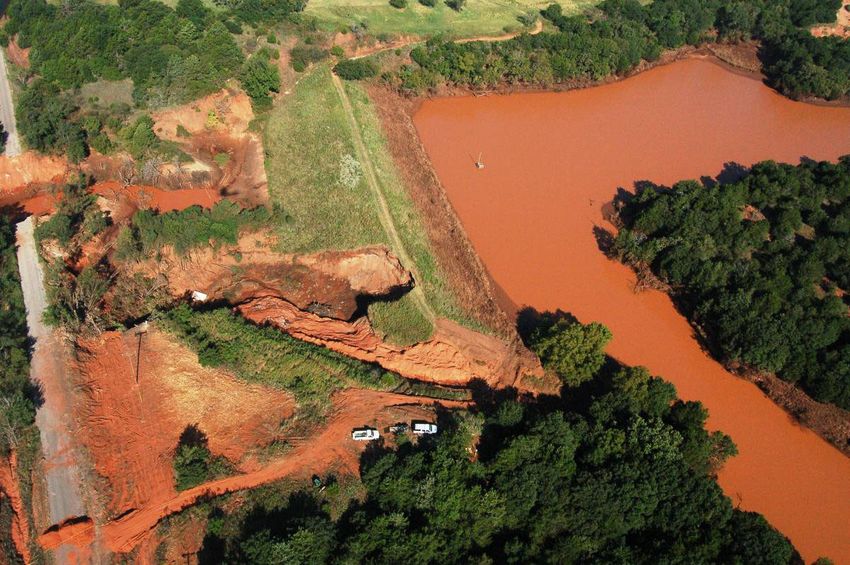
Engineer who arrived at 3:00 PM) along with the OCC Watershed Technician devised a
plan for a track hoe to dig a trench into the sandstone rock on the outside perimeter of
the auxiliary spillway as deep as possible to provide for additional overflow thereby
providing more immediate relief. They determined that they will be able to lower the
water approximately 5 feet. The NRCS State Conservation Engineer had concerns
about such drastic measures and how this would impact the repair of the site, but the
Project Engineer stated that if we don’t do something to get the water down, we won’t
have a dam left to repair. It was agreed by all parties to proceed with the trench. Work
began to cut the trench around 4:00 PM and was completed around 6:00 PM. The
Project Engineer supervised the construction of the AS notch (lowered the water level
about 3 feet on his first pass) and the discharge as water began to flow and the OCC
Watershed Technician remained on site as well. Most of the flow was exiting the
auxiliary spillway away from the dam and sloughing area. Cracking and sloughing
continued throughout the afternoon and evening. The principal spillway (PS) is flowing
at full capacity with the pool elevated about 16 feet above the inlet. The sponsors are
bringing in pumps to expedite the drawdown. The gate is operational but will only be
effective once the PS flow is no longer at full pipe.

       By morning (Tuesday, August 21), the water level was down to the notch that
was cut in the AS (approximately Elev. 1302). By 10:00 AM, the Project Engineer and
the OCC Watershed Technician determined that additional relief could be made by
deepening the notch in the AS. A cut of an additional estimated 2 feet is made. By mid-
afternoon, the slough has seemed to stabilize, but the danger is far from over and the
Project Engineer recommends continuing to keep people out of their homes and away
from the downstream area. The site is monitored throughout the day.

                                        Page 5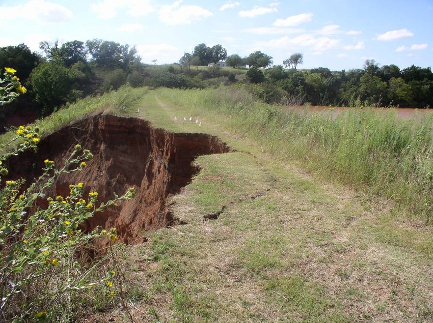
Wednesday (August 22) morning reveals a large crack along the top of the dam.
If the present crack sloughs, the top width of the dam will be reduced to about 4 feet.
(Currently it is at 6 feet approximately) Around 10:00 AM the crack breaks off, and
plans begin immediately for the NRCS State Conservation Engineer and the NRCS
Head Design Engineer, Oklahoma to visit the site. In addition, contacts are made with
the ARS Hydraulics Research Unit Leader (ARS) and the National Design and Soil
Mechanics Center in Ft. Worth. A Design Engineer from the Center also leaves Texas
for the site. The Director of Conservation Operations for OCC proceeds to the site and
orders the three Watershed Technicians and the two 3000 GPM pumps be dispatched
to the location.

       Upon arrival, the slough was past the center line of the dam and vertical for about
35 feet. Additional cracking was evident. Discussions begin to possibly perform a
“controlled breach” as a last alternative to protect downstream interests. The NRCS
State Conservation Engineer and the ARS Hydraulics Research Unit Leader discussed
possible breach scenarios. They determined based on the downstream soils and
topography that the best location would be near the right abutment. The ARS
Hydraulics Research Unit Leader estimated under controlled conditions that the breach
would be fully-involved in about 2 hours, compared to about 30 minutes if a major
slough caused an uncontrolled breach.

       No additional cuts can safely be made in the auxiliary spillway and the only
option available to get more water out of the site is to pump. Access to the pool area
with the large OCC pumps is limited. A road had to be constructed by OCC and the

                                         Page 6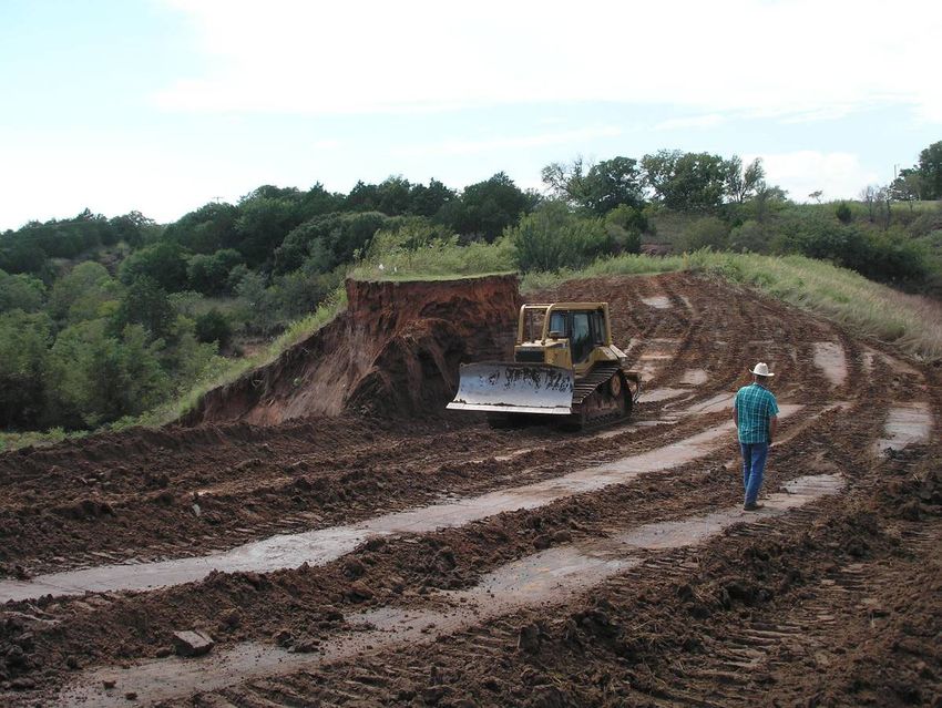
South Caddo Conservation District from the county road, over a high bluff and to the AS
forebay. The pumps are positioned and placed in operation.

       Late on the afternoon of Wednesday August 22, the Emergency Watershed
Protection (EWP) Program Manager, NRCS, Stillwater arrives at the site to discuss
using the EWP program to install protection measures around at least one home
downstream in the event of a breach, controlled or uncontrolled. These plans involve
the installation of concrete “Jersey Walls” around one house. This will not prevent
flooding, but will keep the house from taking the full force of the flow. The NRCS State
Conservation Engineer and EWP Program manager leave the site around 8:00 PM to
evaluate the Jersey Wall option. At that time, the major crack had not sloughed. A
Conservation District employee remains on site until about 10:00 PM.

       By Thursday (August 23), parts of the major crack had sloughed, but not all. It
was noted that previous sloughing had created somewhat of a toe at the base of the
slough and was helping to stabilize some areas. Some parts were still vertical for about
35 feet. NRCS employees from the planning, design, and watershed construction
(surveying) staffs arrived on site to begin planning and design for the rehabilitation. The
site had been tentatively approved for rehabilitation and was on a fast-track for planning
and design. This was a significant step and aided in the decision making process for
how to stabilize the dam.

                                         Page 7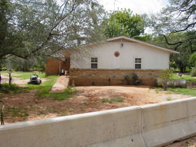
By the time plans were finalized for the Jersey Walls, things seemed to be
stabilizing at the dam site. However as a measure of safety, installation began on the
Jersey Walls around 7:30 PM Thursday and was completed around noon on Friday.

      Flow was still somewhat restricted due to the size of the gate opening. Plans
were developed to cut additional notches in the tower to provide more capacity. This
work requires a dry stable work area and could not start until the water completely
receded.

        Pumping and monitoring continued through the weekend. In addition, the NRCS
staff also formulated plans to begin notching the dam. The notch would not be a
breach, but a cut through the embankment, stopping 1.5 feet above the water level.
Since it would take considerable time to excavate to the desired elevation, the work was
ordered to begin prior to the determination of the final elevation of the notch. As the
water level drops, the notch would be cut lower until an elevation was reached that
would provide some minimal flood protection, but would not be a breach hazard. The
NRCS Hydraulic Engineer in Stillwater worked on determining the desired elevation.
The notch was to be located at the slough area. This would allow excavated material to
be used to fill in the slough and there was more disposal areas along the left abutment.
Salvaging fill was a prime concern for the eventual rehabilitation of the site. Excavation
was to be on a 2:1 slope with a top width of around 200 feet. This would allow for a 10
foot bottom at the maximum cut elevation. If less cut was needed, the bottom width
would be wider. At no time was the cut to be closer than 1.5 feet from the water level.
Work on the notch began on Tuesday afternoon, August 28 (9 days after the event

                                         Page 8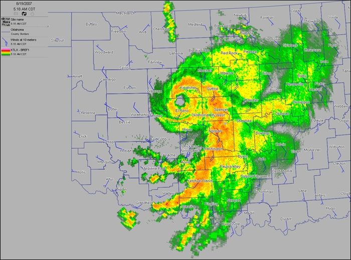
began). This was viewed as an extreme option, but one that would eliminate the threat
downstream allowing people to return to their homes and leave the site in a somewhat
stable state until rehabilitation could begin. If rehabilitation of the site was not an option,
plans would have likely been different.

       On Thursday, August 30, the elevation of the notch was determined to be 1278.
This was based on survey data and computer model evaluations comparing the
downstream channel capacity with the flow expected if the reservoir below the notch
was to breach. In addition, some level of flood storage was desired between the
principal spillway crest and the notch. The 1278 elevation provided protection for a 5
year rainfall event. Construction on the notch reached this elevation on September 4.
The site remains in this condition pending rehabilitation. It is monitored regularly
following major rainfall events. Additional ports were cut in the tower by OCC and
South Caddo Conservation District to increase principal spillway pipe discharge and
provide some level of protection for the notched dam.

                                           Page 9
The design of the rehabilitated site is currently underway. In cooperation with the
sponsors, the county commissioners, the Bureau of Indian Affairs (BIA), and a
consulting engineering firm, the watershed site will be relocated to the road location and
the top of the dam used for the road base. Construction is planned for early 2009.
The Results
While it cannot be said that everything worked smoothly, the events surrounding
Sugar Creek Site L-44 could be categorized as, to quote the movie Apollo 13, “a
successful failure.” The structure did not breach; however, it did fail in the sense that it
could no longer perform its purpose as designed and constructed. Actions taken by the
many individuals listed above prevented a breach and subsequent damages or potential
loss of life.
With any emergency situation, it is good to evaluate the events and document
what worked successfully and also what could have worked better. A perfect
emergency rarely exists. A list of lessons learned was developed by many of the
parties involved in the incident. The following is a list of lessons learned (in no
particular order) from this event that are noted in an effort that they not be repeated
during the next event. In reviewing the lessons learned, it was determined that all had
solutions in an Incident Command System (ICS). This was the most important outcome
of the event.
Since the Sugar Creek Site L-44 event, an official Incident Command System
team specific to dam safety has been created in Oklahoma. It is comprised of NRCS,
Page 10OCC, and Conservation District personnel. Initial training has been provided and other
training events are planned. Table top exercises are being conducted with dam
sponsors and Emergency Management (EM) personnel across the state. Policy and
procedures for both agencies regarding activation of the team are being developed and
equipment needs have been established.
The team has been tested twice to date. A low hazard dam suffered significant
damage in April 2008. The entire auxiliary spillway breached. EM personnel were
notified and some precautionary evacuations were made as well as roads closed. The
event lasted less than one day. ICS procedures were put in place, but a formal incident
was not declared. The team analyzed the event and recommended improvements for
future events.
Less than 2 weeks later, the team was tested again. A high hazard site was
reported to have major seepage problems, the sponsors reported that a situation was
noticed, but were holding off on activating the EAP until the site was analyzed by local
NRCS authorities and an OCC Watershed Technician. The ICS team was put on alert,
but not activated. An analysis of the situation proved to be a non-event, as the seepage
was actually from a leak in the PS, but in no way was endangering the site. This event
too was analyzed by the ICS team to look for improvements.
Each event is a learning experience. The goal of our ICS team is to work in a
safe and efficient manner whenever an event occurs, regardless of the scale. The
procedures will be practiced although a formal activation may or may not occur.
Several key components led to this successful outcome. First and foremost was
the partnership that exists between the NRCS, the OCC, and the local watershed
sponsors. Without this relationship and the resources which each entity brought to the
table, decisions would have been delayed or not made and the results could have been
devastating. Second was the availability of emergency federal funds through the
NRCS’s Emergency Watershed Protection Program along with matching state funds
through the OCC. Immediate actions were needed without regard to costs or financial
obligations. With the backing of the EWP program, such actions were not delayed.
Finally, the availability of the Watershed Rehabilitation Program - knowledge that the
site could and would be rehabilitated greatly aided in making decisions as to how best
to minimize the risk the dam posed, both immediately and until it could be
reconstructed.
Page 11You can also read