2022 LOCAL ROADWAY SAFETY PLAN - Public Draft March 2022 City of Laguna Niguel
←
→
Page content transcription
If your browser does not render page correctly, please read the page content below
2022 LOCAL ROADWAY
SAFETY PLAN          PREPARED
                     FOR

Public Draft         City of
March 2022           Laguna Niguel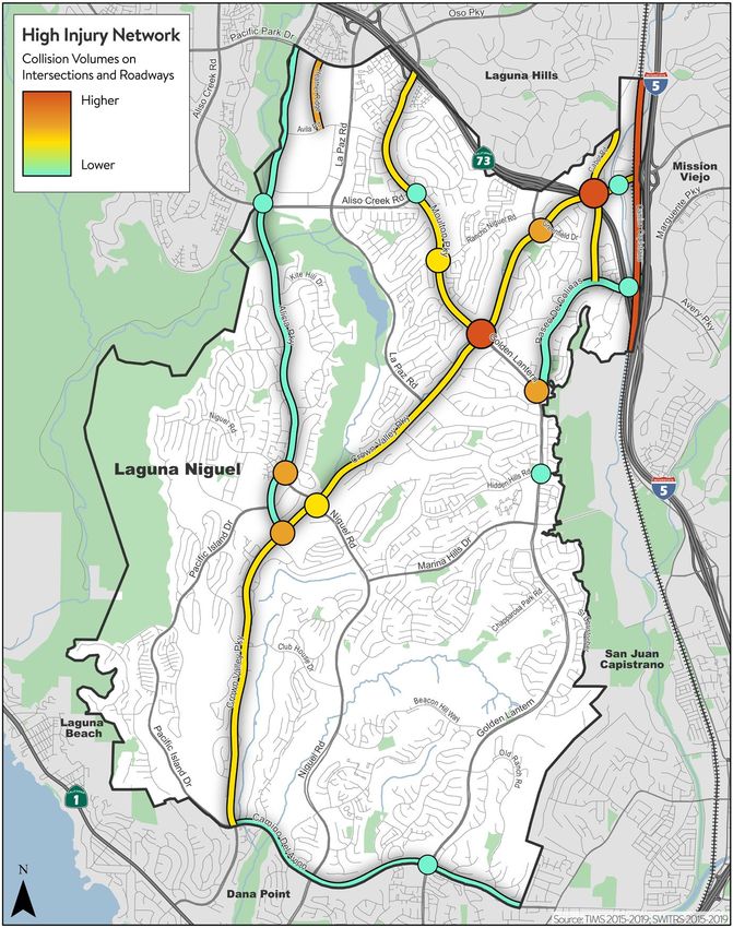
CITY OF LAGUNA NIGUEL
LOCAL ROADWAY SAFETY PLAN
Acknowledgements
The 2022 Laguna Niguel Local Roadway Safety Plan was funded through a grant provided by the California
Department of Transportation (Caltrans). The City of Laguna Niguel, in collaboration with multidisciplinary
partner agencies and stakeholders, collaborated to develop a plan that increased roadway safety for
people traveling within the city’s roadway network. The study was managed by Jacki Scott, PE, TE and
Kathy Nguyen, PE, TE of the City’s Department of Public Works, in coordination with a Stakeholder
Working Group (SWG). A consulting team led by Mark Thomas assisted the City of Laguna Niguel and the
SWG in preparing the plan.
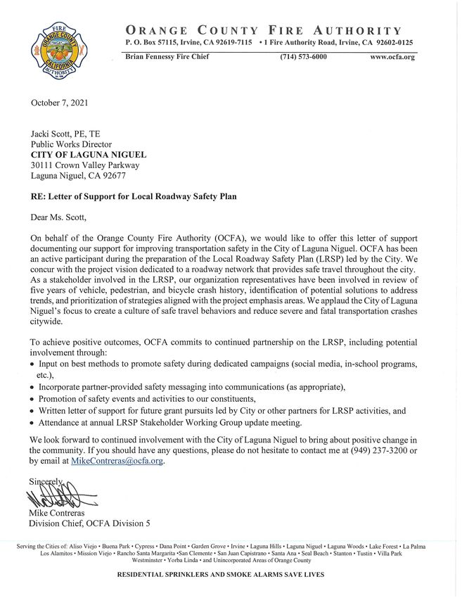
Project Partners Orange County Fire Authority
City of Laguna Niguel Michael Contreras
Jacki Scott Jason Lopez
Kathy Nguyen Orange County Health Care Agency
Edgar Abrenica Maria Minaglia
Jonathan Orduna Orange County Transportation Authority
John Morgan Warren Whitaker
Phil Robinson Orange County Sheriff’s Department
Capistrano Unified School District Isaac Flores
Mike Beekman Joe Bucaro
Jay McNamara
Falck/Care Ambulance Consultant Team
Carolynn Carraway Mark Thomas & Associates
Shane Ryan Paul Martin
Matt Spencer Jae Riddle
Ed Noriega
LRSP 1 OF 50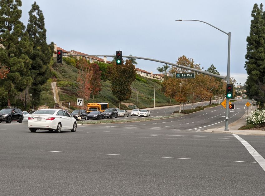
Table of Contents
Introduction ................................................................................................................................................................................................... 4
      Executive Summary ............................................................................................................................................................................... 4
          Study Parameters .................................................................................................................................................................................. 5
     LRSP Development Process ........................................................................................................................................................................5
          Stakeholder Working Group .............................................................................................................................................................. 5
          Vision, Mission, and Goals .................................................................................................................................................................. 6
     Existing Safety Efforts ...................................................................................................................................................................................7
          Traffic Safety Studies ............................................................................................................................................................................ 7
          HSIP Grant Funding Pursuits .............................................................................................................................................................. 9
          Paseo de Colinas Safety Barrier ......................................................................................................................................................... 9
          Bicycle Lane Improvements ................................................................................................................................................................ 9
          High Visibility Crosswalk ...................................................................................................................................................................... 9
          Audible Pedestrian Signals ................................................................................................................................................................. 9
          Speed Feedback Signs ........................................................................................................................................................................10
          Traffic Signal Pre-Emption and Traffic Signal Synchronization............................................................................................... 11
          Youth & Senior Education Efforts ....................................................................................................................................................12
Citywide Collision Data ............................................................................................................................................................................. 13
   Data Collection............................................................................................................................................................................................ 13
          Statewide Integrated Traffic Records System............................................................................................................................... 13
          Office of Traffic Safety Collision Data .............................................................................................................................................13
          Police Traffic Patrol Identified Improvement Locations ........................................................................................................... 14
     Crash Analysis Results ............................................................................................................................................................................... 15
          Crash Data Charts .................................................................................................................................................................................15
          Crash Data Maps .................................................................................................................................................................................. 16
          Crash Tree Diagrams ........................................................................................................................................................................... 17
          High Injury Network Analysis ............................................................................................................................................................19
Emphasis Area Strategies........................................................................................................................................................................ 20
    Emphasis Area 1: Speed Management .......................................................................................................................................... 20
          Emphasis Area 2: Reduce Impaired Driving................................................................................................................................. 22
          Emphasis Area 3: Reduce Distracted Driving .............................................................................................................................. 24
          Emphasis Area 4: Eliminate High-Crash Locations .................................................................................................................... 26
          Emphasis Area 5: Improve Safety at Intersections and Around Schools ............................................................................ 28
          Emphasis Area 6: Increase Active Transportation Road User Safety .................................................................................... 30
          Emphasis Area 7: Increase Safe Driving in Older Adults and Teens ..................................................................................... 32

LRSP                                                                                                                                                                                            2 OF 50
Recommended Infrastructure Improvements.................................................................................................................................... 34
    Speed Management Treatments .................................................................................................................................................... 34
         High-Crash Locations/Intersection Treatments .......................................................................................................................... 35
         Treatments Near Schools and for Active Transportation Users............................................................................................. 37
         Treatments to Support Emergency Vehicle Services ................................................................................................................ 39
    Focus Intersections and Roadways........................................................................................................................................................ 41
Non-Infrastructure (NI) Program Implementation ........................................................................................................................... 42
Infrastructure Project Implementation ................................................................................................................................................ 44
Next Steps................................................................................................................................................................................................... 47
Appendix A: Letters of Support ........................................................................................................................................................ 50

LRSP                                                                                                                                                                                          3 OF 50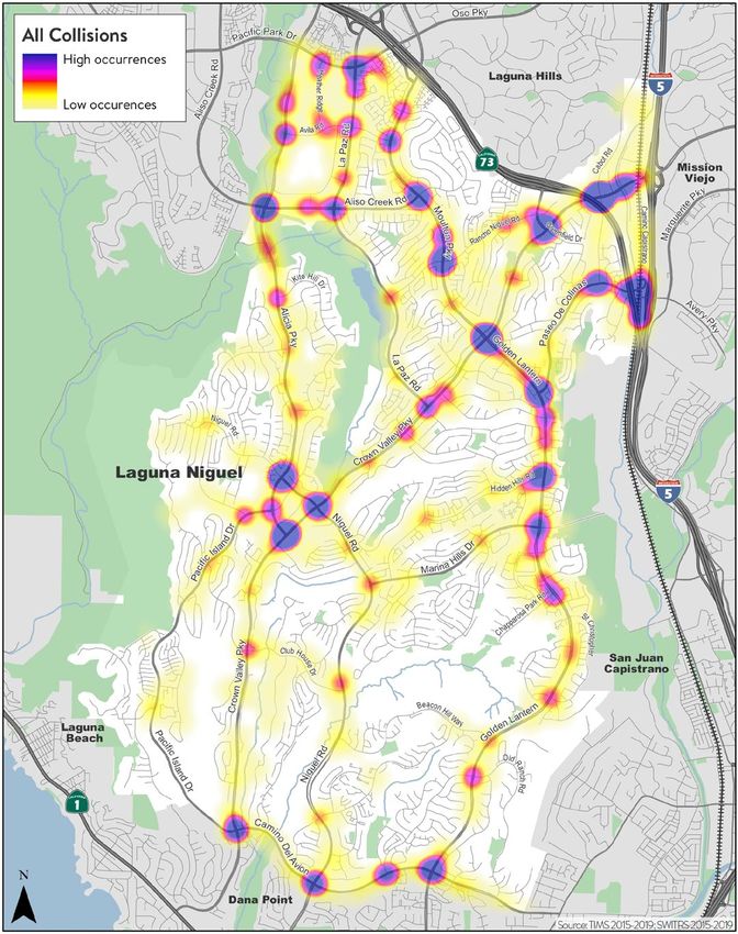
Introduction
Executive Summary
The City of Laguna Niguel is committed to providing a vibrant quality of life for all residents, businesses,
and visitors in a safe, beautiful, and involved community 1. The Laguna Niguel Local Roadway Safety Plan
(LRSP) supports that commitment to preserve quality of life by enhancing public safety on the City’s
roadway network. The purpose of this LRSP is to provide a proactive approach to addressing safety needs
for motorists, bicyclists, and pedestrians on City of Laguna Niguel managed roadways. This LRSP is a living
document which will be reviewed and updated accordingly during annual stakeholder meetings.
Development of the LRSP was funded by the California Department of Transportation (Caltrans).

In an effort to identify and implement roadway safety improvements, the intent of this LRSP is to:
    1. Evaluate and plan for focused improvements on local highway safety needs
    2. Maintain eligibility for future Highway Safety Improvement Program (HSIP) grant funding opportunities
    3. Evaluate crash history affecting all transportation modes
    4. Identify crash types and locations
    5. Develop recommendations for improvements
    6. Develop a Working Group with stakeholders representing multiple disciplines

LRSPs have been proven to reduce fatalities on local roads in states that have implemented them; hence,
implementation of this LRSP will improve transportation safety for the City’s residents and visitors.

As part of this LRSP, a collision database was developed to identify locations with a history of collisions.
The analysis found that 1,340 police-reported crashes occurred on the City of Laguna Niguel
transportation network between January 1, 2015 and December 31, 2019. Of these, 61 resulted in fatalities
or severe injuries (KSI crashes), which represent 5% of all crashes. The study network experiences an
average of 268 crashes and 2 to 3 fatalities per year. The most common type of violation for KSI crashes
was driving under the influence (DUI), which represents 25% of KSI crashes, followed by automobile right
of way, representing 20% of KSI crashes. This LRSP identified collision hotspot locations to be prioritized
for project submission to HSIP infrastructure funding, which include:

           Intersections
               • Cabot Road/Crown Valley                              •   Alicia Parkway/Bike Crossing
                   Parkway                                                (south of Aliso Creek Road)
               • Moulton Parkway-Golden                               •   Alicia Parkway/Niguel Road
                   Lantern/Crown Valley Parkway                       •   Greenfield Drive/Crown Valley
               • Alicia Parkway/Crown Valley                              Parkway
                   Parkway                                            •   La Gracia-Rancho Azul/Rancho
               • Alicia Parkway/Aliso Creek Road                          Niguel Road

1
    Laguna Niguel: 2050 - Pursuit of Happiness Strategic Plan

LRSP                                                                                                4 OF 50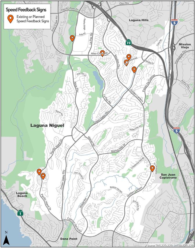
Roadways
          • Paseo de Colinas                                           •   Golden Lantern
          • Crown Valley Parkway                                       •   Alicia Parkway
          • Moulton Parkway                                            •   Aliso Creek Road between Alicia
          • Camino del Avion                                               Parkway and La Paz Road

Additionally, non-infrastructure strategies have been identified in conjunction with key stakeholders and
timeframes for implementation.
Study Parameters
This LRSP evaluates collision history and provides countermeasures for local, collector, and arterial
roadways within the City of Laguna Niguel. The collision database is a compilation of collisions on City
managed roadways between January 1, 2015 and December 31, 2019. The primary source of the collision
database was the Statewide Integrated Traffic Records System (SWITRS), consisting of police-reported
collisions throughout the State of California.

LRSP Development Process
This LRSP project kicked off in April 2021 with a meeting between the City of Laguna Niguel Public Works
Department staff, Orange County Sheriff’s Department representatives, and consultants. The team
discussed the City’s goals for the project, confirmed an outreach and engagement schedule, developed a
Stakeholder Working Group invitee list, and reviewed initial crash analysis data on the City’s roadway
network.
Stakeholder Working Group
The project created a Stakeholder Working Group (SWG) consisting of multi-disciplinary decision-makers
and partners who have played a key role in development of the LRSP. The SWG has furthered the
development process by helping to plan, implement, and evaluate methods to achieve the LRSP’s Vision,
Mission, and Goals.

SWG organizations were selected for their influence over the 4 E’s of transportation safety and ability to
coordinate specialized services for the City of Laguna Niguel within their respective organizations. SWG
representatives customized the LRSP non-infrastructure recommendation, timelines, and responsibilities
according to staff and resource availability. Stakeholders will convene annually, at the request of the City of
Laguna Niguel, to confirm the safety goals and direction of the LRSP.
A total of four SWG meetings occurred on June 10, July 13, August 18, and September 15, 2021 to review
crash data, define the LRSP’s Vision, Mission, and Goals, and organize non-infrastructure (NI) programs to
address the emphasis areas. The SWG collaborated to define lead and support agencies, resources,
communication methods, and implementation timelines for each NI program. Involvement and continued
participation by the SWG members are documented through letters of support included in Attachment A.

LRSP                                                                                                 5 OF 50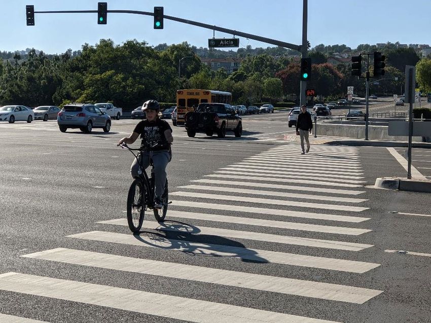
Stakeholder Membership included representatives from the following organizations:
       City of Laguna Niguel
       Capistrano Unified School District
       Falck/Care Ambulance
       Orange County Fire Authority
       Orange County Healthcare Agency
       Orange County Transportation Authority
       Orange County Sheriff’s Department

Vision, Mission, and Goals
The LRSP’s Vision, Mission, and Goals were developed through a collaborative process between City
representatives and SWG members. The resulting feedback between City staff and SWG members
identified the following:

                                                Vision
                           The City of Laguna Niguel is dedicated to a
                           roadway network that provides safe travel
                           throughout the city.

                                             Mission
                           Promote safety and invest resources to reduce
                           traffic hazards.

                                               Goals
                         1. Create a culture of safe travel behaviors

                         2. Educate the community about safe travel
                            practices

                         3. Reduce severe and fatal crashes

                         4. Maintain a safe, thoughtful, and well-
                            managed roadway network

                         5. Collaborate with multidisciplinary partners

                         6. Implement proven cost-effective treatments

LRSP                                                                                           6 OF 50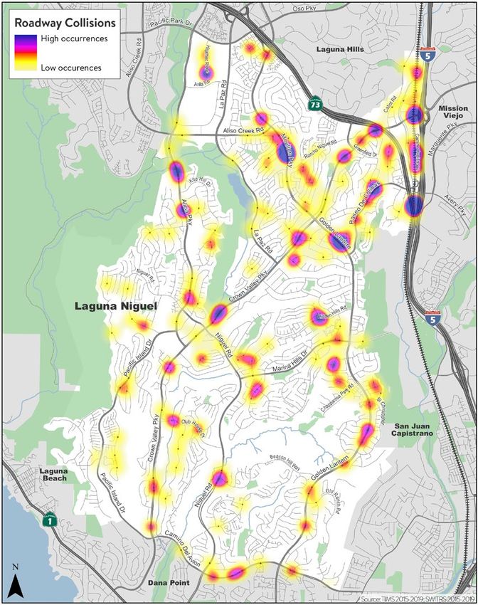
Existing Safety Efforts
The City of Laguna Niguel has demonstrated a history of promoting safety and improving the
transportation network aligned with the City’s Strategic Plan and the LRSP vision. Existing efforts have
included traffic safety studies at multiple locations citywide, education programs for youth and seniors, and
infrastructure improvements, such as installation of traffic signal pre-emption, audible pedestrian signals
(APS), buffered bike lanes, raised medians, speed feedback signs, and traffic calming measures.
Traffic Safety Studies
Traffic Safety Studies are an initiative to evaluate roadway concerns and identify solutions. City staff has
performed data collection, field observations, and analyses to address traffic concerns at multiple locations
citywide:

        Charter School Circulation; April 2020: The City evaluated parking and traffic conditions in the
neighborhoods surrounding Community Roots Academy (CRA) and Orange County Academy of Sciences
and Arts (OCASA) charter school campuses. The surrounding neighborhood is impacted by pick-up and
drop-off parking and traffic, teacher and staff overflow parking, and blocked driveways and streets. Existing
conditions were examined through an outreach workshop, field observations, and average daily traffic
(ADT) volumes to provide recommendations for improving traffic conditions. Recommendations in the
Charter School Circulation Study include installation of all-way stop signs at the school exit driveway,
school-staffed enforcement of pick-up and drop-off locations, and application of red curb paint where
motorists block driveways.

        Intersection Traffic Studies: The City conducted traffic operations and safety evaluations at Alicia
Parkway and Crown Valley Parkway intersection (March 2020), Aliso Niguel and Moulton Parkway
intersection (March 2020), and Westgreen Drive and Club House Drive (September 2020). The studies were
conducted using traffic volume data, collision data, and field reviews. Existing conditions were analyzed to
provide recommendations for improved traffic safety at these intersections.

          Pacific Island Drive; July 2020: The City conducted an evaluation of Pacific Island Drive between
Casalero Drive and Alicia Parkway Drive based on resident feedback concerning motorist speeds and
visibility along the corridor. The Pacific Island Drive evaluation provided a summary and analysis of existing
conditions, collision data, field observations, and recommendations for future improvements.
Recommendations included high visibility pedestrian warning signs, enlarged speed limit signs, and bicycle
lane buffers.

         Clubhouse Stop Signs; June 2021: The City received requests to install stop signs at the
intersections of Club House Drive/Via Lindosa and Club House Drive/Calle Barbosa. A stop sign analysis
evaluated existing conditions at both intersections to determine the necessity of installing new stop signs.
Based on guidance from the City’s Traffic Manual and the California Manual on Uniform Traffic Control
Devices (CA MUTCD), the study determined that limited visibility and vehicle speeds on Club House Drive
justified installation of stop signs on both Via Lindosa and Calle Barbosa at the intersection with Club
House Drive.

LRSP                                                                                                7 OF 50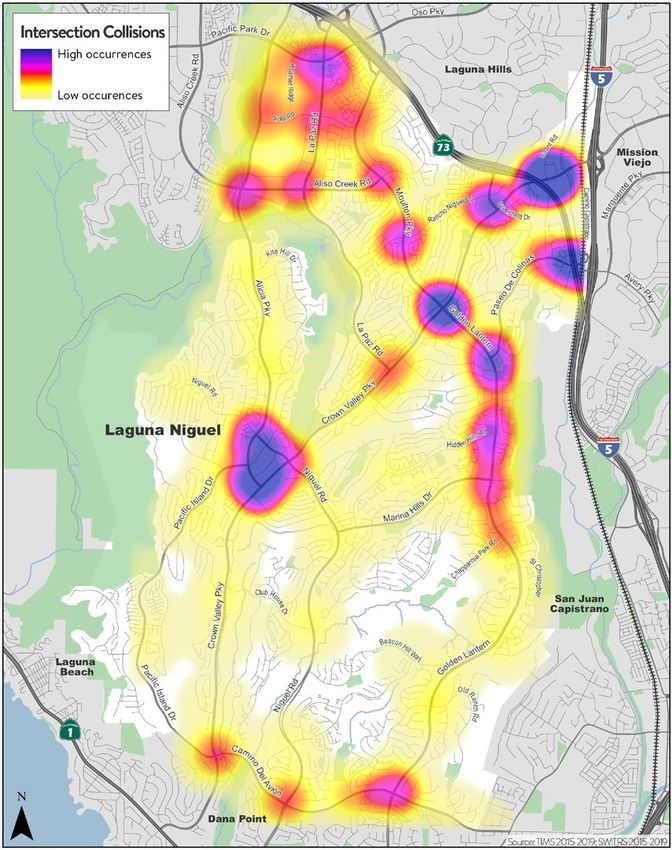
Rancho Niguel Road & Rancho Azul Corridor Operations and Safety Study; August 2020: An
operations and safety study was conducted for the Rancho Niguel Road corridor due to concerns from
community members regarding motorist speeds, traffic safety, and signal control at intersections. Traffic
signal warrant analyses were completed for the unsignalized intersections of Rancho Niguel Road/Rancho
De Linda, Rancho Niguel Road/La Garcia, and Rancho Niguel Road/Rancho Azul. The study concluded that
the Rancho Niguel/La Gracia intersection satisfied the signal warrants, and recommended installation of
new signs and roadway striping modifications.

         Costco Heather Ridge Circulation and Signal Warrant Analysis; July 2021: A signal warrant analysis
was completed for Heather Ridge/Costco driveway intersection. The analysis included review of average
daily traffic (ADT), collision data, and field observations. Results of the study indicate multiple treatment
types are applicable at the intersection to improve traffic flow, including a traffic signal, signage, and a
designated left turn pocket. The City of Laguna Niguel and Costco are continuing to coordinate on the
study’s results and next steps for improved traffic operations.

                 Figure 1 Rancho Niguel Road & Rancho Azul Corridor Operations and Safety Study Excerpt

LRSP                                                                                                      8 OF 50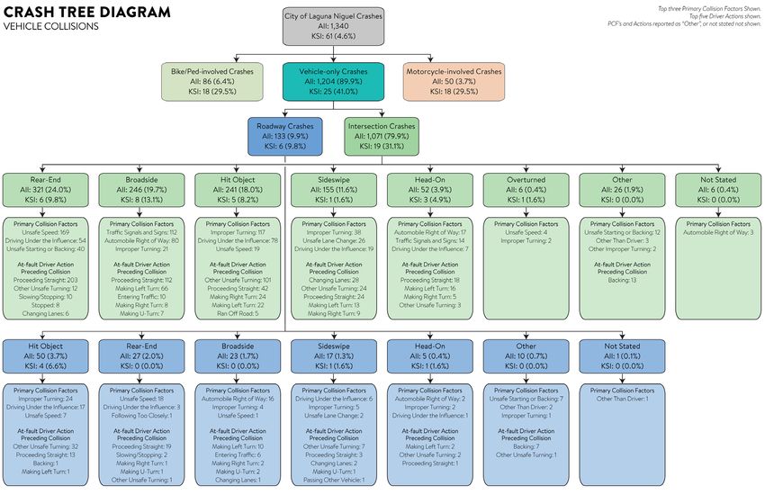
HSIP Grant Funding Pursuits
       In late 2020, the City of Laguna Niguel submitted an HSIP grant application to
       improve Rancho Niguel Road corridor, including a traffic signal at La Gracia-Rancho
       Azul and roadway lane striping modifications.

       Paseo de Colinas Safety Barrier
       In 2020, the City of Laguna Niguel installed a concrete safety barrier to address history
       of crashes concentrated at the site location. The barrier reduces severity of crashes
       near the crossing of the creek and railroad tracks. This is an example of data-driven
       engineering treatments applied to address a common, specific type of vehicle crash.

       Bicycle Lane Improvements
       The City has tested the installation of buffers between motor vehicle travel lanes and
       existing on-street bike lanes on Alicia Parkway in 2020 and Crown Valley Parkway in
       2019. The use of buffered bike lanes has enhanced the separation between cyclists and
       motorists along these roadways and, in specific areas, has utilized 11-feet wide travel
       lanes. The initial demonstration projects have been implemented without documented
       motorist concerns, achieving an improved condition for both motorists and cyclists.

       High Visibility Crosswalk
       The City implemented a pilot program in 2020 applying “continental” crosswalks,
       proven to increase effectiveness in visibility of people crossing the street. This
       treatment was implemented at Alicia Parkway and Aliso Creek Road, a high-use
       location by youth, bicyclists, and pedestrians. This treatment raised crosswalk visibility,
       provided for a safer street crossing, and has been well-received by the community.

       Audible Pedestrian Signals
       Accessible Pedestrian Signals (APS) are pedestrian push buttons that communicate
       when it is safe to cross the street in a non-visual manner, benefitting safety for the
       visually impaired community when crossing roadways at traffic signals. The City has
       implemented APS equipment at approximately 20 signalized intersections, most
       recently in 2021, with plans to install at another 15 locations.

LRSP                                                                                     9 OF 50
Speed Feedback Signs
Speed feedback signs (SFS) have been installed by the City, most recently in 2021, to reduce
speeding behavior through improved driver awareness of actual speed versus posted speed
limits. Locations where SFS have been installed or planned for installation include:
Rancho Niguel Road Figure 2 Existing and Planned Speed Feedback Signs
Facing Eastbound Traffic, West of
Rancho de Linda.
Facing Westbound Traffic, at Rancho de
Linda.
Pacific Island Drive
Facing Northbound traffic, North of
Starview Lane.
Facing Southbound traffic, North of
Starview Lane.
Golden Lantern
Facing Northbound traffic, at Dunes.
Aliso Creek Road
Facing Eastbound traffic, East of Niguel
Heights Boulevard.
Facing Southbound traffic, North of
Skate Park Way.
Crown Valley Parkway
Facing Southbound Traffic, at Glenrock.
Existing SFS have proven to provide speed
reduction benefits. Permanent or
temporary SFS will continue to be
implemented in areas with high numbers of
speed related crashes.
LRSP 10 OF 50Traffic Signal Pre-Emption and Traffic Signal Synchronization
Traffic signal pre-emption systems provide remote communication between the traffic
signal and an approaching emergency response vehicle, allowing the response vehicle
control over the signal phasing. The use of pre-emption equipment is estimated to
reduce emergency vehicle response times by up to 25%. The City has proactively
installed traffic signal pre-emption at all City-managed traffic signals.
The Regional Traffic Signal Synchronization Program (RTSSP) and Traffic Light Synchronization Program
(TLSP) are initiatives by the Orange County Transportation Authority to coordinate signals along 750 miles
of roadway within Orange County. The two programs reduce congestion, idling at the intersection, and
increase vehicle capacity along a corridor by synchronizing signals to turn green before vehicles arrive at
the intersection. The following list identifies projects completed by the City of Laguna Niguel to
synchronize corridors and the year in which new signal timing was implemented or is planned for
implementation:
• TLSP Projects
o Pacific Park / Oso Parkway (TLSP Pilot project along with Euclid) 2008
o 1st Alicia (Crown Valley to Olympiad) 2009
• RTSSP Projects
o 1st Moulton/Golden Lantern (Camino Del Avion to SR55) 2010
o Crown Valley (PCH to Antonio) 2013; (Operations and Maintenance) 2016
o La Paz Road (Crown Valley to Felipe) 2014; (Operations and Maintenance) 2017
o 2nd Moulton/Golden Lantern (Camino Del Avion to Lake Forest) 2017; (Operations and
Maintenance) 2020
o Alicia (Crown Valley to Rustic Oak) 2019; Operations and Maintenance) 2022
o Aliso Creek Road (Moulton to El Toro) 2022
LRSP 11 OF 50Youth & Senior Education Efforts
City staff have annually coordinated with Capistrano Figure 3 City prepared School Zone Brochure
Unified School District (CUSD) staff and local school
principals to evaluate traffic operations at local
schools and identify efforts to improve circulation and
safety for youth and parents traveling to/from school.
In 2021, the City created updated Safe Routes to
Schools maps and traffic safety brochures for
distribution to school audiences. Additionally, City
staff have made presentations to youth discussing the
role of City government to manage the
transportation network and provide safety guidance.
The City of Laguna Niguel Sea Country Senior Center
has held various in-person and online Driver’s
Education Courses, including a California Department
of Motor Vehicles (DMV) written test preparation course, Drivers Safety Course hosted by the American
Association of Retired Persons (AARP), presentation by the California Highway Patrol (CHP), and an online
guide by the DMV. These courses are available to senior drivers throughout the City of Laguna Niguel.
Figure 4 Laguna Niguel Senior Resource Guide - Figure 5 Suggested Walking and Bicycling Routes – Laguna
Transportation - Cover Page Niguel Elementary School
LRSP 12 OF 50Citywide Collision Data Data Collection This LRSP was developed using a data-driven approach toward identifying locations and behaviors contributing to collisions on the City’s roadway network. Resources utilized include the Statewide Integrated Traffic Records System, Office of Traffic Safety Collision Data, and direct input from the Orange County Sheriff’s Department. Statewide Integrated Traffic Records System A collision database was comprised of local police-reported crashes as published by the Statewide Integrated Traffic Records System (SWITRS) between January 1, 2015, and December 31, 2019. SWITRS database collisions without geocoordinates were located within the City using the Transportation Injury Mapping System 2 (TIMS) matching Case ID. During screening, few crash incidents needed subsequent identification of geocoordinates based on identified primary road, secondary road, distance from intersection, and direction from intersection. If desired, future updates to the LRSP can supplement the statewide published crash data through review of injury data provided by the local ambulance provider. A records evaluation provided a descriptive analysis of crash data at the citywide level and crash density maps for primary collision factors, crash types, roadway crashes, intersection crashes, and total crashes. The collision data forms the basis for identifying crash-based countermeasures for implementation at focus corridors and intersections, as well as emphasis area recommendations. Office of Traffic Safety Collision Data Additional information on citywide collisions is provided by the California Office of Traffic Safety (OTS). OTS develops annual collision rankings for all California cities and counties. OTS rankings from 2018, the latest year available, indicate that Laguna Niguel ranks 99th out of 102 similarly sized jurisdictions (with a larger number indicating positive comparative results). The positive outcome of the statewide OTS rankings indicate the crash history within the City of Laguna Niguel is low when compared to cities of similar size. 2 TIMS is an online application by SafeTREC that geocodes and assigns coordinates to SWITRS collision data, excluding property damage only collisions. LRSP 13 OF 50
Figure 6 Office of Traffic Safety 2018 Crash Rankings for the City of Laguna Niguel

Police Traffic Patrol Identified Improvement Locations
Orange County Sheriff’s Department (OCSD) traffic patrol staff provided input based on observations at
the following locations for potential improvement:

       Alicia Parkway/Aliso Creek Road
       Alicia Parkway/Bike Crossing (south of Aliso Creek Road)
       Alicia Parkway/Niguel Road
       Aliso Creek Road between Alicia Parkway and La Paz Road
       Golden Lantern/Crown Valley Parkway
       Greenfield Drive/Crown Valley Parkway

LRSP                                                                                                      14 OF 50
Crash Analysis Results
Crash Data Charts
Crash data charts provide Figure 7 Five-Year Collision Trendline Figure 8 Five-Year Severity Trendlines
graphic illustrations of
crash types and primary
collision factors and
informed decisions the
LSRP’s developing
emphasis areas. The
dataset indicates crashes
in Laguna Niguel occur at
an average of 268 total
collisions and 2 to 3 fatal
or severe injury collisions
(KSI) per year.
Figure 9 Total and KSI Collision Types Figure 10 Total and KSI Primary Collision Factors
LRSP 15 OF 50Crash Data Maps
Collisions were mapped using Geographic Information Systems (GIS) software to Figure 13 Heatmap of All Citywide Collisions
illustrate the distribution of collisions within the dataset. Heatmaps were generated from
the crash data to illustrate the density of collisions citywide and filtered for roadways or
intersections.
Figure 11 Heatmap of All Roadway Collisions Figure 12 Heatmap of All Intersection Collisions
LRSP 16 OF 50Crash Tree Diagrams Crash tree diagrams illustrate Figure 14 Crash Tree Diagram of Collisions Involving a Pedestrian, Bicyclist, or Motorcyclist possible outcomes of events by following possible paths along the “tree” branches. The diagrams illustrate probability of varying crash types as defined by mode, location, crash type, and primary collision factor. Crash tree diagrams provide a detailed perspective regarding travel behaviors throughout the network. The crash trees include total crashes as well as fatal and serious injury crashes; however, the major cause of the crash and manner of crash are reported only for total crashes. In the City, the fatal and serious injury crashes had similar major causes and manners of crash as the total crashes. LRSP 17 OF 50
Figure 15 Crash Tree Diagram of All Collisions Involving Motor Vehicles Only

LRSP                                                                                  18 OF 50
High Injury Network Analysis                                                       Figure 16 High Injury Network Intersections and Roadways
To identify high-crash locations within the City, a High-Injury Network
(HIN) methodology was applied to the 5-year crash dataset. Crashes
involving a fatality were weighted at 3.0, and crashes involving a severe
injury were weighted at 1.5. Crashes were identified as intersection or
roadway crashes when location within or in extent of 500-feet of an
intersection, respectively. To calculate the density of crashes, GIS was
applied to measure the linear distance of roadway centerline miles
within the City. Roadway crashes were then divided by the number of
centerline miles within the City to identify crashes per mile.

The following three (3) intersections had the most reported crashes:
   1. Cabot Road/Crown Valley Parkway
   2. Moulton Parkway-Golden Lantern/Crown Valley Parkway
   3. Alicia Parkway/Crown Valley Parkway

The following six (6) roadways had the highest volume of reported
severity-adjusted crashes:
   1. Paseo de Colinas*
    2. Crown Valley Parkway
    3. Moulton Parkway
    4. Camino del Avion
    5. Golden Lantern*
    6. Alicia Parkway

*A review of collisions on Paseo De Colinas, between El Sur and Camino
Capistrano, found 59% of motorists were descending the hill prior to causing a
collision. The slope of the Paseo De Colinas hill is approximately 6% between El
Sur and Camino Capistrano. Similar percentages are expected on Golden Lantern
past Hidden Hills Road.

LRSP                                                                                                                                          19 OF 50
Emphasis Area Strategies
During input from the SWG members and review of documented crash data between 2015 and 2019, the
following seven (7) project emphasis areas were identified to improve travel safety:
1. Speed Management
2. Reduce Impaired Driving
3. Reduce Distracted Driving
4. Eliminate High-Crash Locations
5. Improve Safety at Intersections and Around Schools
6. Increase Active Transportation Road User Safety
7. Increase Safe Driving in Older Adults and Teens
The following details recommended actions to address the LRSP emphasis areas based on input and
information provided by the SWG. While the SWG provided input to prioritize the following emphasis
areas, additional transportation safety improvements can be implemented through regular review and
evaluation by City staff.
Emphasis Area 1: Speed Management
• Collisions caused by unsafe speed are the Figure 17 Severity and Crash Type in Unsafe Speed Collisions
second most-common primary collision
factor and represent 19% of the dataset.
• Unsafe speeds most often result in rear-
end collisions and have caused zero
fatalities between 2015 and 2019.
• Approximately 2% of unsafe speed
collisions result in a KSI.
Goal for Emphasis Area 1:
• Reduce Unsafe Speed collisions from 2%
KSI to 0% KSI
Strategy for Emphasis Area 1: Reduce motorist speeding through education, enforcement, and
infrastructure improvements at specific locations.
Action 1.1: Community Education Campaigns. Leverage existing OTS resources and implement a
citywide campaign to address speeding behavior. This campaign will target all motorists throughout the
community, with an emphasis on school communities and will be distributed through digital media and
printed brochures.
LRSP 20 OF 50Table 1 Action 1.1 Programming
Lead City of Laguna Niguel Develop and distribute annual content and distribution methods
Support Capistrano Unified Distribute printed material to new drivers (Juniors & Seniors) at high
School District schools annually concurrent with issuance of parking permits.
Promote City-prepared “School Traffic Safety” brochure and content
through CUSD Communications.
Orange County Health Review messaging and content in advance of publishing.
Care Agency
Promote content with local 4th District Parent Teacher Association (PTA)
representatives & after school programs
Funding Office of Traffic Safety
Timeline 1st Year
Action 1.2: Police Enforcement. Focus police enforcement on roadways that frequently experience high
motorist vehicle speeds or have high numbers of speed-related crashes.
Table 2 Action 1.2 Programming
Lead Orange County Conduct speed enforcement on roadways with high speeding behavior
Sheriff’s Department and high speed-related crashes.
Pursue grant funding to conduct the program.
Support City of Laguna Niguel Provide annual crash data to inform the locations and time frames to
effectively implement speed enforcement campaigns.
Funding Office of Traffic Safety
Timeline 1-5 Years
Action 1.3: Infrastructure Treatments. Implement infrastructure treatments proven to reduce unsafe
vehicle speeds and lower crash risk factors at locations where unsafe speed collisions most commonly
occur. Unsafe Speed collisions occurred most frequently on Crown Valley Parkway (26%), Golden Lantern
(14%), and Alicia Parkway (13%).
Table 3 Action 1.3 Programming
Lead City of Laguna Niguel Pursue grant, local, or regional funding for infrastructure treatments.
Implement infrastructure treatments at key locations.
Support All Partners Provide Letter of Support for grant pursuits
Funding Highway Safety Improvement Program
State and Regional Grants
Timeline 1st-5 Years
LRSP 21 OF 50Emphasis Area 2: Reduce Impaired Driving
• Collisions caused by driving under the Figure 18 Severity and Crash Type of DUI Collisions
influence are the third most-common
primary collision and represent 16% of the
dataset.
• Laguna Niguel ranked 62nd out of 102 for
collisions involving an intoxicated driver
under the age of 21 per OTS rankings.
• Approximately 7% of driving under the
influence collisions result in a KSI.
Goal for Emphasis Area 2:
• Reduce DUI KSI crashes from 7% to 4% or
lower.
• Provide vouchers for 100 sober free rides home in the first 6 months of program implementation.
Strategy for Emphasis Area 2: Increase access to sober rides, implement targeted campaigns, and enact
sobriety checkpoints citywide.
Action: 2.1: Ride Hail Promotions. Coordinate with a ride-hail company (e.g., Uber, Lyft, etc.) to provide
citywide vouchers for a sober ride home, eligible for riders ages 16 and up. Vouchers may be eligible year-
round or during critical periods of the year, such as holidays and regional events. Program advertising will
be strategically placed near locations where driving under the influence is likely to originate. Distribution
methods include digital and printed media such as physical advertisements, social media, subscriber
newsletters, and news coverage.
Table 4 Action 2.1 Programming
Lead City of Laguna Niguel Coordinate with ride-hail service providers.
Support Orange County Provide guidance and lessons learned to City based on prior joint
Transportation OCTA/City of San Clemente ride-hail voucher program.
Authority
Orange County Provide guidance regarding DUI trip origins.
Sheriff’s Department
Participate in distribution of vouchers
Funding Office of Traffic Safety
Timeline 1-5 Years
Action 2.2: Focused Education Campaigns. Leverage Office of Traffic Safety (OTS) resources and
implement a citywide campaign to address impaired driving. Communication methods include digital
media, social media, and video advertisements.
LRSP 22 OF 50Table 5 Action 2.2 Programming
Lead City of Laguna Niguel Develop and distribute content and distribution methods.
Support Orange County Provide resources from past, existing, or future campaigns to
Transportation supplement city efforts.
Authority
Consider promotion of campaign messaging on interior/exterior of
OCTA buses where feasible.
Consider a full-wrap bus to promote a campaign subject to review of
financial impacts.
Orange County Participate in campaign funding pursuit, content development,
Sheriff’s Department distribution methods, and promotion.
Funding Office of Traffic Safety
Timeline 1st Year
Action 2.3: Sobriety Checkpoints. Conduct DUI Figure 19 DUI Collisions by Month of the Year
checkpoints on holidays or timed with local events
when drivers are more likely to drive under the
influence.
DUI collisions in the dataset most commonly
occurred in February and October and on Crown
Valley Parkway (16%) and Golden Lantern (15%).
Crash data trends can be used to inform locations
and time frames to implement DUI checkpoints
within the City.
Table 6 Action 2.3 Programming
Lead Orange County Conduct DUI Checkpoints.
Sheriff’s Department
Support City of Laguna Niguel Pursue funding to conduct DUI checkpoints.
Funding Office of Traffic Safety
Timeline 1-5 Years
LRSP 23 OF 50Emphasis Area 3: Reduce Distracted Driving
• Of associated factors catalogued in the Figure 20 Driver at Fault Cause of Collision
collisions’ party at fault, inattention is the
third most common recorded factor, after
“violation” and “none apparent”.
Goal for Emphasis Area 3:
• Increase citations for distracted motorists
by 50% in the first implementation year of
High Visibility Enforcement program.
• Distribute campaign materials to all
parking-permit holding students, 4th District
PTA representatives, and 4th District PTA
after school program participants within the City.
• Train 100 parent participants in the Parent Intervention Program in the first year of implementation.
Strategy for Emphasis Area 3: Develop a culture against distracted driving through campaigns, training,
and enforcement.
Action 3.1: High Visibility Enforcement. Implement increased police presence supported by paid and
earned media in support of laws banning the use of handheld cell phones while driving. Communication
methods include website, digital, and social media.
Table 7 Action 3.1 Programming
Lead Orange County Increase citation efforts against distracted driving.
Sheriff’s Department
Support City of Laguna Niguel Pursue grant funding to support the Orange County Sheriff’s
Department’s efforts.
Funding Office of Traffic Safety
Timeline 1-5 Years
Action 3.2: Parent Intervention Program. Create a program directed at parents to educate their teens
about the importance of driving without distractions. Target audience for the program includes parents of
teen drivers. Communication methods include website, digital, and social media.
LRSP 24 OF 50Table 8 Action 3.2 Programming
Lead City of Laguna Niguel Create a new “how-to” brochure for parents to discuss safe driving
behavior and methods to avoid distractions with new youth drivers.
Support Capistrano Unified Distribute City content and consider requiring students commit to
School District distraction-free driving behavior as a condition of securing parking
permits.
Orange County Support content development and methods to evaluate results with
Healthcare Agency parents.
Orange County Participate in campaign funding pursuit, content development,
Sheriff’s Department distribution methods, and promotion.
Funding Office of Traffic Safety
Timeline 1st Year
Action 3.3: Regional Education Campaigns. Leverage Office of Traffic Safety (OTS) resources and
implement a campaign directed towards drivers aged 16 and over to address the dangers and
consequences of distracted driving. Distribution methods include posters, banners, videos on digital and
social media, and advertisements.
Table 9 Action 3.3 Programming
Lead City of Laguna Niguel Develop and distribute content and distribution methods.
Support Capistrano Unified Distribute City content to students and parents.
School District
Orange County Consider leading interactive classes for student drivers subject to OCHCA
Healthcare Agency staff resource availability. Training could be virtual and in-class training.
Orange County Participate in campaign funding pursuit, content development,
Sheriff’s Department distribution methods, and promotion.
Funding Office of Traffic Safety
Timeline 1st Year
LRSP 25 OF 50Emphasis Area 4: Eliminate High-Crash Locations
• High-crash intersections include:
o Cabot Road and Crown Valley Parkway (average 12.4 collisions per year)
o Crown Valley Parkway and Moulton Parkway/Golden Lantern (average 8.9 collisions per
year)
o Alicia Parkway and Crown Valley Parkway (average 7.3 collisions per year)
• High-crash roadways include:
o Paseo de Colinas (average 10.8 collisions per mile per year)
o Crown Valley Parkway (average 9.7 collisions per mile per year)
o Moulton Parkway (average 8.9 collisions per mile per year)
o Camino del Avion (average 8.3 collisions per mile per year)
o Street of the Golden Lantern (average 8.2 collisions per mile per year)
o Alicia Parkway (average 7.7 collisions per mile per year)
Goal for Emphasis Area 4:
• Implement infrastructure treatments at three intersections within 2-3 years.
• Implement infrastructure treatments along six roadways within 2-3 years.
Strategy for Emphasis Area 4: Conduct Road Safety Audits and develop infrastructure improvements for
inclusion in the City’s Capital Improvement Program.
Action 4.1: Road Safety Audits. Public Works staff will continue to contract Road Safety Audits, as
described earlier in this LRSP. A Road Safety Audit (RSA) is the formal safety performance examination of
an existing or future road or intersection by an independent, multidisciplinary team. It qualitatively
estimates and reports on potential road safety issues and identifies opportunities for improvements in
safety for all road users 3.
Table 10 Action 4.1 Programming
Lead City of Laguna Niguel Contract licensed professionals to perform Road Safety Audits.
Funding FHWA Office of Safety
FHWA Division Offices
State DOT
Highway Safety Improvement Program (HSIP)
State and Community Highway Safety Grant Program (Section 402)
Transportation Alternatives Program
Timeline 1-5 Years
3
Crowe, B., & Allred, C. (2018, August 10). Road safety Audits (RSA) - Safety: Federal Highway Administration.
Safety. Retrieved September 9, 2021, from https://safety.fhwa.dot.gov/rsa/.
LRSP 26 OF 50Action 4.2: Capital Improvement Program. Utilize LRSP identified intersections and roadways for capital
improvement and pursue grant, local, or regional funding for implementation of infrastructure treatments
that will 1) reduce crash risk factors 2) address the type of collisions and primary collision factor at the
high-crash location 3) have a high benefit to cost ratio, and 4) have high systematic applicability. The City
will consider treatments for incorporation in the City of Laguna Niguel Capital Improvement Program and
follow an incremental approach to solutions dependent on conditions and needs.
Table 11 Action 4.2 Programming
Lead City of Laguna Niguel Consider LRSP-identified infrastructure projects for funding pursuits and
inclusion in the City’s Capital Improvement Program.
Funding Highway Safety Improvement Program
Orange County Transportation Authority (OCTA) Measure M2 Regional Capacity Program (Project O)
Timeline 1-5 Years
Figure 21 Engineering Recommendations Require Multi-Year Efforts for Planning, Funding, and Implementation
LRSP 27 OF 50Emphasis Area 5: Improve Safety at Intersections and Around Schools
• The majority of collisions in the dataset Figure 22 All and KSI Collisions by Location
occurred at or approaching an intersection
throughout the City.
• Collisions at or approaching intersections
occur at an average of 237 per year.
• Pedestrian injury is the third-leading cause
of injury-related death among elementary
and middle schoolers in the United States 4
• Child pedestrians involved in crashes stayed
longer in hospitals and had more severe
injuries than adult pedestrians 5.
Goal for Emphasis Area 5:
• Reduce collisions at or approaching intersections by 25%.
• Develop a set of effective infrastructure recommendations for each school within the City.
Strategy for Emphasis Area 5: The City will prioritize intersection improvements to reduce the severity and
likelihood of collisions at or approaching intersections.
Action 5.1: Intersection Improvements with Emerging Technologies. The City’s Department of Public
Works will incorporate emerging technologies for intersection improvements. According to the National
Highway Traffic Safety Administration, 94% of serious crashes are due to dangerous choices or errors
made by drivers 6. Roadways equipped with emerging technology designed to support autonomous
vehicles (AV) may reduce collisions due to human error. While emerging technology will continue to
evolve, existing recommendations include lane markings, roadside sensors, and smart signage.
Table 12 Action 5.1 Programming
Lead City of Laguna Niguel Incorporate emerging technology into City’s projects as applicable.
Prioritize emerging technology implementation at intersections near
schools.
Funding Automated Driving System Demonstration Grants by U.S. Department of Transportation
Timeline 1-5 Years
4
Borse NN, Gilchrist J, Dellinger AM, Rudd RA, Ballesteros MF, Sleet DA. CDC childhood injury report: Patterns of
unintentional injuries among 0-19 years olds in the United States, 2000–2006. Atlanta: National Center for Injury
Prevention and Control, CDC; 2008.
5
Robert W. Derlet, Joseph Silva, James Holcroft, Pedestrian accidents: Adult and pediatric injuries, The Journal of
Emergency Medicine, Volume 7, Issue 1, 1989.
6
https://www.nhtsa.gov/technology-innovation/automated-vehicles-safety
LRSP 28 OF 50Action 5.2: Countermeasure Monitoring. Public Works staff will apply police-reported collision data
from SWITRS or TIMS to review the pre-construction and post-construction benefits of infrastructure
treatments. Countermeasure monitoring results will benefit future funding pursuits for built improvements
by illustrating measurable differences in traffic safety following the implementation of treatments.
Table 13 Action 5.2 Programming
Lead City of Laguna Niguel Develop a process for analyzing pre-construction and post-construction
traffic safety at locations planned for infrastructure improvements.
Funding California Active Transportation Program
Safe Routes to School Technical Assistance Resource Center
Timeline 5+ Years
Figure 23 Continental Crosswalk at Aliso Creek Road Crossing Alicia Parkway
LRSP 29 OF 50Emphasis Area 6: Increase Active Transportation Road User Safety
• Collisions involving pedestrians or bicyclists Figure 24 All and KSI Collisions by Mode of Travel
have a higher likelihood of resulting in a
fatality or serious injury (KSI), according to
the dataset.
• Bicyclists involved in a collision are 9 times
more likely to result in a KSI than a
motorist.
• Pedestrians involved in a collision are 17
times more likely to result in a KSI than a
motorist.
Goal for Emphasis Area 6:
• Reduce collisions involving a pedestrian to
>1 per year.
• Reduce collisions involving a bicyclist to >1 per year.
Strategy for Emphasis Area 6: Pursue grant funding to construct pedestrian and bicycle improvements or
implement non-infrastructure safety programming and implement engineering solutions specifically to
increase pedestrian and bicyclist safety.
Figure 25 Woman with stroller and youth on scooter crossing in a crosswalk near commercial and park uses
LRSP 30 OF 50Action 6.1 Engineering Solutions. The City will apply data analysis and planning studies to determine
locations citywide where engineering solutions are needed for bicycle and pedestrian safety. It is
recommended that City staff continue to monitor crash data affecting youth riding on bicycles (electric and
non-electric) near local schools to determine engineering, education, or enforcement strategies to address
potential increases.
Table 14 Action 6.1 Programming
Lead City of Laguna Niguel Develop and implement treatments to enhance safety for pedestrians
and bicyclists at key locations.
Support Orange County Coordinate with the City to plan for safety treatments consistent with the
Transportation Guidance for Administration of the Orange County Master Plan of
Authority Arterial Highways.
Funding Caltrans Active Transportation Program
Caltrans Sustainable Communities Grant
Timeline 5+ Years
Action 6.2: Pursue Grant Funding. The City will submit applications to State and Federal programs to
fund identification, design, and construction of pedestrian and bicycle safety improvements and consider
pursuit of funding for local police offering of bicycle infraction “traffic diversion” program consistent with
Assembly Bill 902 (2016).
Table 15 Action 6.2 Programming
Lead City of Laguna Niguel Pursue grant funding to study, develop recommendations, and construct
improvements for pedestrians and bicyclists.
Support All SWG Agencies Promote project initiatives and provide letters of support
Funding Caltrans Active Transportation Program
Caltrans Sustainable Communities Grant
Timeline 1-5 Years
LRSP 31 OF 50Emphasis Area 7: Increase Safe Driving in Older Adults and Teens
• Teenage drivers (age 14 to 19) account for Figure 26 Age Distribution of Drivers Causing Collisions
13% of drivers who are “at fault” in a
collision within the dataset.
• Older drivers (age 70 and over) account for
12% of drivers who are “at fault” in a
collision within the dataset.
Goal for Emphasis Area 7:
• Reduce collisions caused by teenage drivers
by 50%
• Reduce collisions caused by older drivers
by 50%
Strategy for Emphasis Area 7: The City will implement separate, targeted campaigns for older adults and
teens and coordinate with OCTA to provide safe and more comfortable alternatives to driving.
Action 7.1: Targeted Campaigns for Older Adults. Utilize AARP and AAA resources to educate the
senior community (ages 65 and over) about safe driving practice as they age. Distribution methods include
print and digital media at Sea Country Senior Center.
Table 16 Action 7.1 Programming
Lead City of Laguna Niguel Partner with the Sea Country Senior Center to present and distribute
available published materials.
Support Orange County Continue providing alternatives to driving for older adults through OC
Transportation Bus Senior Discounts and OC Flex Microtransit services.
Authority
Promote content through OCTA communication channels to target
audience.
Funding Office of Traffic Safety
Orange County Transportation Authority
Southern California Association of Governments
Timeline 1st Year
LRSP 32 OF 50Action 7.2: Targeted Campaigns for Teens. Continue safety campaigns such as Every 15 Minutes
campaign that educates teens about safe driving behaviors and provide alternatives to driving.
Table 17 Action 7.2 Programming
Lead Orange County Fire Continue organizing annual “Every 15 Minutes” campaign; 2-day
Authority program on distracted/impaired driving. Typically coordinated with
CUSD, OCSD, Coroners Dept, Care Ambulance.
Support Capistrano Unified Continue partnership with partners to ensure annual delivery of the
School District “Every 15 Minutes” safety education program at relevant schools.
Orange County
Sheriff’s Department
City of Laguna Niguel Promote the effort and campaign through organized City
communication methods.
Orange County Continue providing alternatives to driving for teens through OC Flex
Transportation Microtransit services and free transit rides for youth aged 6 to 18 on fixed
Authority route busses.
Funding Office of Traffic Safety
California Highway Patrol
California Department of Alcoholic Beverage Control
Timeline 1st Year
Figure 27 “Every 15-Minutes” campaign demonstration of collision caused by intoxicated driving
LRSP 33 OF 50Recommended Infrastructure Improvements
As described throughout the emphasis areas, engineering Figure 28 Local Roadway Safety Manual Cover Page
treatments are recommended throughout the City to address
specific traffic collision trends, specifically for Actions 1.3, 4.2,
5.1, 6.1, 6.2, and 7.3. Engineering treatments and
countermeasures are identified to address documented crash
history and specific locations identified by City staff and OCSD
representatives. Countermeasures funded by HSIP for
implementation have empirical before/after studies that
document the crash reduction factor (CRF) which represents
the expected percent decrease in crashes upon implementation
of the countermeasure.
Countermeasures with a CRF are identified in the following
published document created by Caltrans in conjunction with
the Federal Highway Administration (FHWA) and Safe
Transportation Research and Education Center (SafeTREC) at
the University of California, Berkeley:
1. Local Roadway Safety, A Manual for California’s Local
Road Owners (Version 1.5, April 2020)
Where an infrastructure recommendation is included in the Local Roadway Safety Manual then a unique
identifier is provided such as S02 for improved signal hardware.
Speed Management Treatments
1. Speed Limit Pavement Markings: Where speeding traffic problems have been documented, speed limit
pavement markings may be installed to remind drivers to check their speed. Speed limit pavement markings
are numerals applied in the traffic lane to remind drivers of the regulatory speed limit. In addition, a “SLOW”
word legend may be applied with the speed legend. The treatment 1) provides a clear indication of the
speed limit to drivers who are watching the road; 2) does not become obscured by streetside vegetation
growth, parked trucks, or other obstructions; 3) is relatively easy and low cost to install; and 4) does not slow
emergency vehicles.7
2. Install Speed Feedback Signs (SFS): SFS at select locations within the City to reduce speeding behavior
through improved driver awareness of actual speed versus posted speed limits. SFS equipment is already
installed at various locations throughout the City. Existing SFS have provided speed reduction benefits.
Permanent or temporary SFS will continue to be implemented in areas with high numbers of speed related
crashes.
7
https://www.cabq.gov/neighborhood-traffic-management-program/documents/speed-limit-pavement-
markings.pdf
LRSP 34 OF 50You can also read