Toorak Road, Kooyong Level Crossing Removal Project - Incorporated Document May 2019
←
→
Page content transcription
If your browser does not render page correctly, please read the page content below
Toorak Road, Kooyong
Level Crossing Removal Project

Incorporated Document
May 2019

Incorporated document pursuant to section 6(2)(j) of the Planning and Environment Act 1987
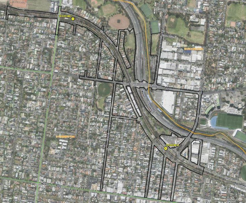
1.0 INTRODUCTION

This is an Incorporated Document in the Stonnington and Boroondara Planning Schemes
(the planning schemes) pursuant to section 6(2)(j) of the Planning and Environment Act
1987.

The land identified in Clause 3.0 of this document may be used and developed in
accordance with the specific controls in Clause 4.0 of this document.

The control in this Incorporated Document prevails over any contrary or inconsistent
provision in the planning schemes.

2.0 PURPOSE

The purpose of this Incorporated Document is to allow the use and development of land
described in Clause 3.0 for the purposes of the Toorak Road, Kooyong Level Crossing
Removal Project (the Project).

3.0 LAND

This document applies to the land shown on the planning scheme maps as SCO2 in the
Stonnington Planning Scheme and SCO1 in the Boroondara Planning Scheme (the Project
Land).

An indicative location of land covered by the incorporated document is provided in Figure 1,
attached.

4.0 CONTROL
4.1 EXEMPTION FROM PLANNING SCHEME REQUIREMENTS

Despite any provision to the contrary, or any inconsistent provision, in the planning schemes,
no planning permit is required for, and no provision in the planning schemes operates to
prohibit, restrict or regulate the use or development of the Project Land for the purposes of,
or related to, constructing, maintaining or operating the Project.

The use and development of the Project Land for the purposes of, or related to, the Project
includes, but is not limited to, the following:
a) Demolition, buildings and works for the removal of the level crossing at Toorak Road,
   Kooyong where it crosses the Glen Waverley rail line.
b) Road and railway works, including but not limited to, works to facilitate the grade
   separation of rail and road infrastructure and provision of new rail and road
   infrastructure, relocation of utilities and installation of new utility infrastructure,
   earthworks, replacement of track infrastructure, access tracks, landscaping, vegetation
   removal and bicycle and pedestrian shared use paths.
c) Use and development of land for a railway, including railway tracks and associated
   communications, signalling and other rail related infrastructure.
d) Use and development of land for informal outdoor recreation.
e) Buildings and works to facilitate the development of new publicly accessible spaces and
   public realm improvements including, but not limited to, streetscape and landscape
   works and associated infrastructure for informal outdoor recreation.
f)   Creation and alteration of access to roads.
g) Relocation of telecommunications infrastructure.
h) Associated rail infrastructure, including power upgrades and overhead infrastructure,
   cabling and signaling.
i)   Bus stops, car parking, bicycle facilities, landscaping, and loading and unloading
     facilities.
j)   Ancillary activities, preparatory and enabling works, including, but not limited to:
     i)       Creating and using lay down areas for construction purposes.
     ii)      Temporary stockpiling of excavation material for construction purposes.
     iii)     Constructing and using temporary site workshops and storage, staff car parking,
              administration and amenities buildings.
     iv)      Removing, destroying and lopping of trees and removing vegetation, including
              native vegetation and dead native vegetation.
     v)       Demolishing and removing buildings, structures, infrastructure and works.
     vi)      Relocating, modifying and upgrading services and utilities.
     vii)     Constructing fences, temporary site barriers and site security.
     viii)    Constructing or carrying out works to create or alter roads, car parking areas,
              bunds, mounds, landscaping, or drainage, or to excavate land salvage artefacts
              and alter drainage.
     ix)      Constructing and using temporary access roads, diversion roads and vehicle
              parking areas, loading and unloading areas, access paths and pedestrian
              walkways.
     x)       Creating or altering access to a road in a Road Zone, Category 1 or land in a
              Public Acquisition Overlay if the purpose of acquisition is for a Category 1 road.
     xi)      Earthworks including cutting, stockpiling and removal of spoil, and formation of
              drainage works.
     xii)     Displaying construction, directional and identification signs.
     xiii)    Subdividing and consolidating land.

4.2 CONDITIONS

The use and development permitted by this document must be undertaken in accordance
with the following conditions:

Environmental Management Strategy

4.2.1        An Environmental Management Strategy (EMS) must be prepared to the
             satisfaction of the Minister for Planning. The EMS must be prepared in consultation
with Stonnington City Council and Boroondara City Council (the councils). The EMS
must include:
a) A summary of key construction methodologies.
b) An overarching framework for site or work specific measures to reduce and
manage environmental and amenity impacts during construction of the Project.
c) A summary of the consultation that informed the preparation of the EMS and a
summary of the proposed ongoing engagement activities with the councils, the
community and other stakeholders during construction of the Project including
enquiries and complaints management.
d) A summary of performance monitoring and reporting processes, including
auditing, to ensure environmental and amenity impacts are reduced and
managed during construction of the Project.
Native vegetation
4.2.2 Prior to removal of native vegetation (excluding native vegetation removed under
the clause below relating to preparatory buildings and works), information about that
native vegetation in accordance with Application Requirements 1, 5 and 9 of the
Guidelines for removal, destruction or lopping of native vegetation (DELWP,
December 2017) (Guidelines) must be provided to the satisfaction of the Secretary
to the Department of Environment, Land, Water and Planning (DELWP). For the
avoidance of doubt, the information provided to the Secretary to DELWP must
include information about any native vegetation that has been, or is to be, removed
under the clause below relating to preparatory buildings and works.
4.2.3 Prior to removal of native vegetation (excluding native vegetation removed under
the clause below relating to preparatory buildings and works), the biodiversity
impacts from the removal of that native vegetation must be offset in accordance
with the Guidelines, and evidence that the required offset(s) has been secured must
be provided to the Secretary to DELWP.
4.2.4 In exceptional circumstances, the Secretary to DELWP may vary the timing
requirement in the clause above.
4.2.5 The secured offset(s) for the project may be reconciled at the completion of the
project in accordance with the Assessor’s handbook – Applications to remove,
destroy or lop native vegetation (DELWP, October 2018).
4.2.6 For the purpose of this document, the term ‘remove native vegetation’ includes to
destroy and/or lop native vegetation.
Heritage management
4.2.7 Where, but for this Incorporated Document, a planning permit would be required
under the planning schemes for buildings and works within a Heritage Overlay, site
plans and elevations (or other documentation as agreed by the Minister for
Planning) showing the extent of buildings and works must be prepared to the
satisfaction of the Minister for Planning, except as otherwise agreed by the Minister
for Planning.
4.2.8 Where, but for this Incorporated Document, a planning permit would be required
under the planning schemes for the demolition, alteration or removal of a building
within a Heritage Overlay, a full photographic survey of the building/s, comprisingphotographs of both the exterior and interiors of the buildings and contextual
images of the buildings environs and their settings, must be prepared to the
satisfaction of the Minister for Planning, except as otherwise agreed by the Minister
for Planning.
Flood management
4.2.9 Buildings and works on the land within the Special Building Overlay or Land Subject
to Inundation Overlay must be undertaken to the satisfaction of the relevant
floodplain management authority.
Creating and altering access to roads, or works within a PAO (Road)
4.2.10 Where, but for this Incorporated Document, an application to create or alter access
to a road in a Road Zone, Category 1 or to land in a Public Acquisition Overlay for
which the Roads Corporation is the acquiring authority, would be referred to the
Roads Corporation, the creation or alteration of access must be undertaken to the
satisfaction of the Roads Corporation.
4.2.11 Before a plan of subdivision is certified under the Subdivision Act 1988, the consent
of the Roads Corporation must be obtained to subdivide land adjacent to a road
declared as a freeway or arterial road under the Road Management Act 2004, land
owned by the Roads Corporation for the purpose of a road, or land in a Public
Acquisition Overlay if the Roads Corporation is the acquiring authority for the land.
4.2.12 Where, but for this Incorporated Document, an application to use, construct or carry
out buildings and works and/or remove vegetation from, land within a Public
Acquisition Overlay where the Roads Corporation is the acquiring authority would
require planning approval, such use, building and works or vegetation removal must
be undertaken to the satisfaction of the Roads Corporation.
Other conditions
4.2.13 Unless otherwise stated, the plans and other documents listed in Clause 4.2 must
be approved prior to the commencement of works. Plans and other documents may
be prepared and approved for separate components or stages of the Project but
each plan or other document must be approved before commencement of works for
that component or stage.
4.2.14 The plans and other documents may be amended from time to time to the
satisfaction of the Minister for Planning or relevant approving authority. In deciding
whether a plan or other document is satisfactory or whether to consent to an
amendment to a plan or other document, the Minister for Planning may seek the
views of the councils or any other relevant authority.
4.2.15 The use and development of the Project Land must be undertaken generally in
accordance with the approved plans and documents.
4.3 PREPARATORY BUILDINGS AND WORKS AND ASSOCIATED USES
The following buildings and works may be undertaken and the Project Land may be used in
the following manner, before the plans and other documents listed in Clause 4.2 are
approved:a) Preparatory buildings and works for the Project including, but not limited to:
i) Works, including vegetation removal, where but for this Incorporated Document, a
planning permit would not be required under the provisions of the planning
schemes.
ii) Investigating, testing and preparatory works to determine the suitability of land,
and property condition surveys.
iii) Creation and use of construction access points, accessways and working
platforms.
iv) Site establishment works including temporary site fencing and hoarding, site
offices, and hardstand and laydown areas.
v) Construction, protection, modification, removal or relocation of utility services, rail
signalling, overhead and associated infrastructure.
vi) Establishment of environment and traffic controls, including designation of ‘no-go’
zones.
vii) Establishment of temporary car parking.
viii) Demolition to the minimum extent necessary, to enable preparatory works.
ix) Salvage and relocation of aboriginal cultural heritage material and other
management actions required to be undertaken in compliance with a cultural
heritage management plan approved under the Aboriginal Heritage Act 2006 or
otherwise in compliance with the Act.
b) The removal, destruction or lopping of native vegetation to the minimum extent
necessary to enable preparatory works. Prior to the removal of native vegetation
relating to preparatory buildings and works information about the native vegetation to
be removed must be provided to the Secretary to DELWP. The information provided to
the Secretary to DELWP must include a description of, and maps showing, the native
vegetation to be removed in accordance with Application Requirement 1 of the
Guidelines. The biodiversity impacts from the removal of native vegetation relating to
preparatory buildings and works must be included in the total biodiversity impacts
when determining the offset(s) in accordance with the ‘native vegetation’ clauses of
this incorporated document.
5.0 EXPIRY
The controls in this document expire if any of the following circumstances apply:
• The development allowed by the control is not started by 1 December 2022.
• The development allowed by the control is not completed by 1 December 2025.
• The use allowed by the controls is not started by 1 December 2025.
The Minister for Planning may extend these periods if a request is made in writing before the
expiry date or within three months afterwards.Figure 1: Indicative location of land covered by the incorporated document
You can also read


