Wildfire Mitigation Plan Update - Public Utilities Board April 28, 2021 - Anaheim.net
←
→
Page content transcription
If your browser does not render page correctly, please read the page content below
Wildfire Mitigation
Plan Update
Public Utilities Board
April 28, 2021

Legislative / Regulatory Background
Senate Bill (SB) 901 effective September 21, 2018
• Modified Public Utilities Code (PUC) Section 8387: publicly-owned
  utilities to develop by 2020 and then annually present a
  comprehensive Wildfire Mitigation Plan

Assembly Bill (AB) 1054 effective July 12, 2019
• Established state and regulatory Wildfire Safety Advisory Board
  (WSAB), and created a $21B Wildfire Insurance Fund for Investor-
  owned Utilities

Guidelines for POUs’ 2021 Wildfire Mitigation Plans
issued by WSAB December 9, 2020

                                                                      2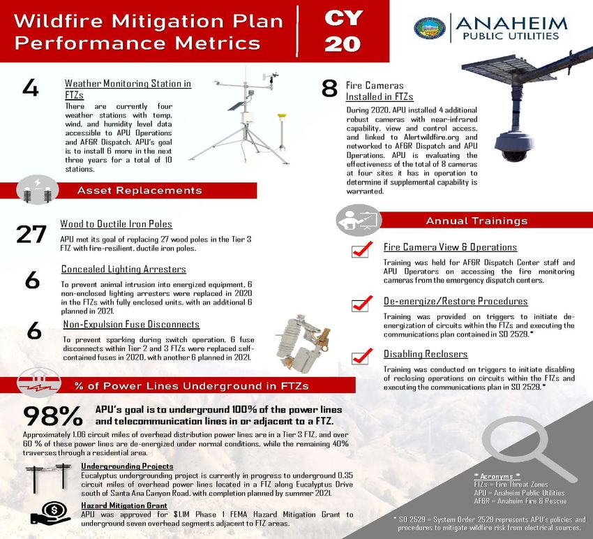
Current Plan
Independently reviewed
Approved by City Council
May 2020
Submitted to State Wildfire
Safety Advisory Board
(WSAB)
Selected as demonstrating
best industry practices
3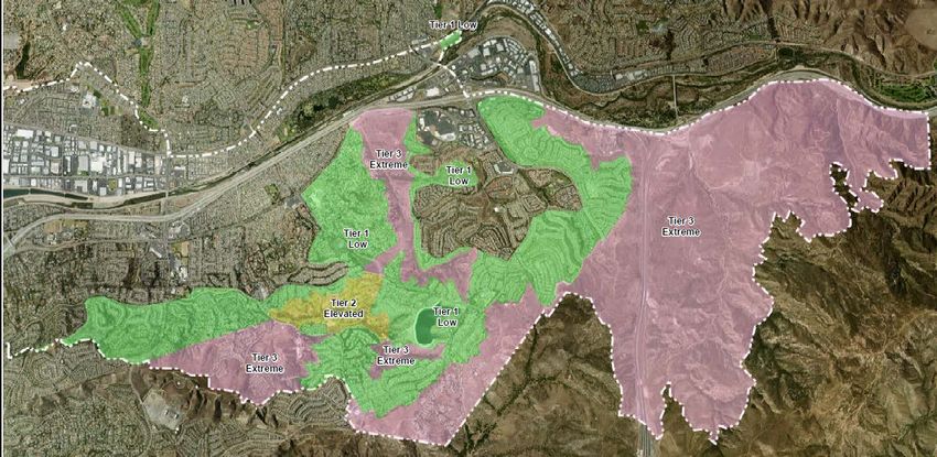
WSAB Guidance Advisory
Template approach
Independent evaluation
Customer engagement
Grid maintenance and hardening
Risk identification
Situational awareness
Vegetation management
4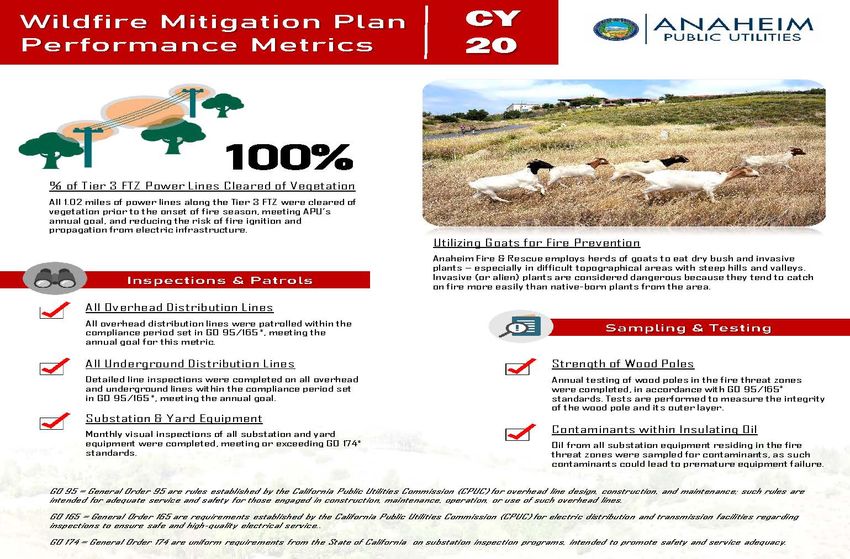
2021 Plan Updates
7 red flag warnings; no power line
ignitions
Eucalyptus undergrounding in
construction
Awarded FEMA grant for design of
7 additional overhead lines in High
Fire Threat Zones
Cameras effectively used by AF&R
in Blue Ridge and Silverado fires
5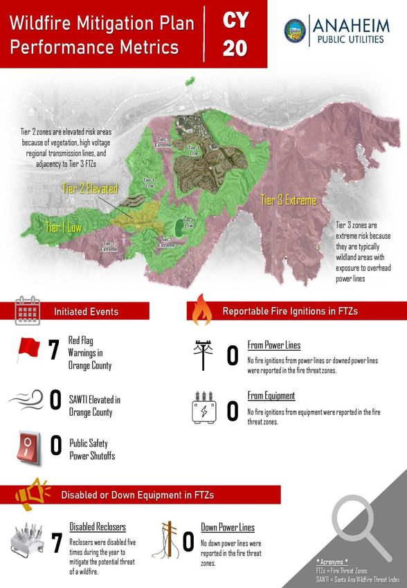
Eucalyptus Undergrounding Progress

                                     6
Fire Impacts
Evacuations for Blue Ridge fire   Silverado fire evacuees return to
lifted, resident describes        O.C. neighborhoods surrounded
‘intense’ experience as           by scorched earth, but no homes
helicopter made a water drop      destroyed
OC Register, Oct. 29, 2020        OC Register, Oct. 28, 2020

                                                                  7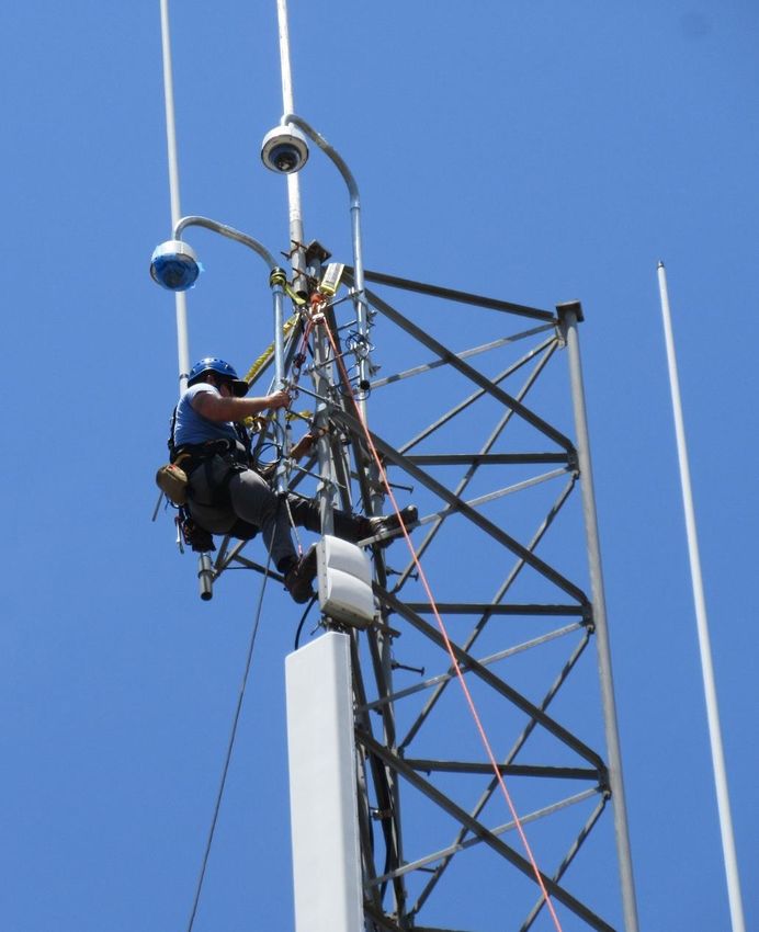
QUESTIONS?

             8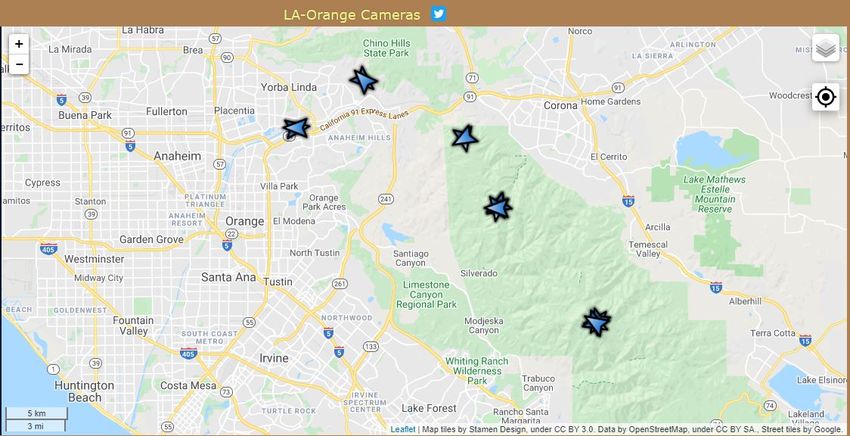
1
TABLE OF CONTENTS

SECTION 1- Introduction                                                       3
       A. Introduction                                                        3
       B. Overview and Objectives                                             5
SECTION 2- Enterprise-wide Safety Risk Assessment                             12
SECTION 3- Dynamic Climate Change                                             13
SECTION 4- Overview of Risks and Risk Drivers Related to Wildfires            13
SECTION 5- Assessment of High Fire Threat in APU Electric Service Territory   16
SECTION 6- Asset Inventory in High Fire Threat Zones                          19
SECTION 7- Overview of Preventative Strategies and Programs                   21
SECTION 8- Situational Awareness                                              22
SECTION 9- Preventative Strategies to Build Resiliency                        26
       A. Vegetation Management                                               26
       B. System Inspection and Maintenance                                   28
       C. Construction Standards                                              29
       D. Pole Loading and Wire Spacing                                       30
       E. Contact by Foreign Objects                                          31
       F. Undergrounding Power Lines                                          32
SECTION 10- Operational Strategies to Reduce Risk of Fire Ignition            32
       A. System Patrols                                                      32
       B. Circuit Reclosers                                                   33
       C. Communication Network                                               33
       D. De-Energize Power Lines                                             33
       E. Summary of Operational Strategies                                   34
SECTION 11- Customer Support in Emergencies                                   35
       A. Community Outreach                                                  35
       B. Emergency Response                                                  35
       C. Community Support                                                   37
       D. Post Event Restoration Response                                     37
SECTION 12- Workforce Training                                                38
SECTION 13- Organization and Assignment Responsibilities                      38
SECTION 14- Metrics and Reporting                                             40
SECTION 15- Monitor and Auditing                                              44

                                                                                   2
SECTION 1- Introduction
A. Introduction
The Anaheim Public Utilities Department (APU) began providing electric utility services to the
City of Anaheim (Anaheim) in 1895. Anaheim’s population has grown to approximately
360,000 and there are 20,000 businesses located in the city. Anaheim is the 10th largest city in
California, with the only municipally-owned electric and water utility in Orange County. APU is
governed by the Anaheim City Council who appoints a Public Utilities Board that serves as an
advisory body consisting of local residents to provide recommendations and reviews APU’s
operations, finances, and conducts public hearings.
The following table provides a brief overview of APU service area and topology.
Table 1: Attributes of Anaheim Public Utilities
Attribute APU
Service Territory Size 50 square miles
200 MW Electric Generation
393 Circuit Miles of Overhead Electric Distribution
742 Circuit Miles of Underground Electric Distribution
18,824 Million Gallons (MG) of Water Production
Owned Assets 754 miles of Water Distribution
920 MG Open Water Reservoir
36 MG Closed Water Reservoir
23 miles of Overhead Fiber Optic
110 miles of Underground Fiber Optic
Number of Customers Served 121,000 electric customer accounts, 64,000 water customer accounts
Population Within Service Territory 360,000
Number of Accounts Share of Total Load (MWh)
85.3% Residential 21.5% Residential
Customer Class Makeup 14.4% Commercial 26.6% Commercial
0.2% Industrial 32.8% Industrial
0.1% Other 19.1% Other
86.5% Urban
11.4% Shrub / Herbaceous
Service Territory
1.2% Barren / Agriculture
Location/Topography 1
0.9% Conifer Forest
0.1% Water
Service Territory 11.9% Wildland Urban Interface
Wildland Urban Interface 1.7% Wildland Urban Intermix
(based on total area)
Percent of Service Territory in Tier 2: 0.7%
CPUC High Fire Threat Districts Tier 3: 13.9%
(based on total area)
3Attribute APU
Prevailing Wind Directions & Wind direction in Anaheim is most often from West for 9.3 and from East
Speeds by Season for 2.6 months, respectively, with an average wind speed of 2-14 mph
Percent of Owned Lines in CPUC Tier 2: 0.06%
High Fire Threat Districts Tier 3: 1.21%
Customers have ever lost service ☐ Yes
due to an IOU PSPS event? No
Customers have ever been notified ☐ Yes
of a potential loss of service to due No
to a forecasted IOU PSPS event?
Has developed protocols to pre- Yes
emptively shut off electricity in ☐ No
response to elevated wildfire risks?
Has previously pre-emptively shut ☐ Yes
off electricity in response to No
elevated wildfire risk?
Anaheim is about 50 square miles and divided into six Council Districts (see Figure 1). For the
purpose of this Wildfire Mitigation Plan (WMP), the areas considered to be in the Fire Threat
Zone (FTZ) are generally in District 6, or the eastern portion of Anaheim.
Figure 1. Anaheim service territory and Council District Boundaries
APU is a Participating Transmission Owner (PTO) with the California Independent System
Operator (CAISO) and is interconnected to the regional grid at 220 kilovolts (kV) and distributes
power from its fourteen 69 kV to 12 kV substations located throughout Anaheim through
approximately 1,200 circuit miles of sub-transmission and distribution lines. APU’s historic
peak demand is 596 Megawatts (MW). In 1990, the Anaheim City Council authorized an
Underground Conversion Program to underground overhead lines along major thoroughfares,
and in 2016 amended the program to expand the types of eligible projects that include reliability
improvements such as wildfire safety. To date, 135.9 circuit miles have been undergrounded as
a result of this program. APU also features the first fully underground substation in the United
States that is located in District 6 that provides reliability, aesthetic, and operational benefits to
the community. APU is also a full service water utility and has its Walnut Canyon Reservoir, a
4920 million gallon facility, in the eastern part of Anaheim that has been used extensively by
water carrying aircraft during regional fires.
Figure 2 (a) Park Substation (b) Walnut Canyon Reservoir during Canyon Fire 2
Wildfire safety is a critical issue in Anaheim. As recently as 2017, a wind-driven wildfire
(Canyon Fire 2) destroyed homes and caused the evacuation of thousands of residents in
Anaheim. The cause of Canyon Fire 2 was embers from a previous wildfire, and no APU sub-
transmission or distribution lines were impacted as approximately 98% of APU-owned power
lines in the FTZ are currently underground, which significantly reduces the overall risk to the
community. As a customer-owned utility, APU emphasizes safety, reliability and affordability
in its daily operations and long-term investments.
B. Overview and Objectives
This WMP establishes methods and procedures used to construct, maintain, and operate APU’s
electrical lines and equipment to minimize the risk of wildfire posed by its infrastructure. The
provisions set forth below outline the preventative strategies and actions for fire prevention and
suppression activities and specific operational response during elevated fire and weather
conditions to limit potential electric sources of fire ignition in the FTZ within APU’s service
territory.
The WMP was initially developed to meet the provisions mandated in Senate Bill 1028 (Hill),
which became law in 2016 and requires all public and private utilities and corporations to assess
whether portions of the geographical area where the utility’s overhead electrical lines and
equipment are located has a significant risk of a catastrophic wildfire resulting from those
electrical lines and equipment, and if so, present mitigation measures the utility intends to
undertake to minimize that risk. In 2018, SB 901 (Dodd) was adopted which outlined the
elements to be included when assessing the risks and formulating a WMP.
The WMP elements include:
1) Objectives of the WMP;
2) A Fire Threat Assessment including location and weather condition warnings;
3) Identification of utility assets located in Tier 3 FTZ and immediately adjacent thereto;
54) A description of the preventative strategies and programs to be adopted to minimize the
risk of APU electrical lines and equipment causing catastrophic wildfires including
vegetation management, system inspection, and construction standards;
5) A description of the factors used to determine when it may be necessary to de-energize
electrical lines and deactivate its reclosers;
6) A description of the metrics used to evaluate WMP performance and discussion of how to
use performance metrics to enhance ongoing plans;
7) An accounting of the responsibilities of persons responsible for executing the WMP;
8) Monitoring and audit provisions that support implementation of the WMP, and
identifying any deficiencies or areas for improvement; and
9) Ongoing monitoring and audit of the effectiveness of electrical line and equipment
inspections.
Additionally, this WMP includes a summary of emergency shut-off procedures to de-energize
power lines if they are at risk of coming into contact with each other and creating a spark due to
high winds or other events. Table 2 is a summary of the elements required within a SB 901 plan
as compared to the elements included in this WMP.
Table 2. Elements Consistent with SB 901-Public Utilities Code Section 8387(b)
Section
Requirement Statute and Description
Number
Persons PUC § 8387(b)(2)(A): An accounting of the responsibilities of
10(D),11,13
Responsible persons responsible for executing the WMP
Objectives of the
PUC § 8387(b)(2)(B): The objectives of the WMP 1
Plan
PUC § 8387(b)(2)(C): A description of the preventive strategies and
Preventative programs to be adopted by the POU to minimize the risk of its
3, 7, 8, 9, 10
Strategies electrical lines and equipment causing catastrophic wildfires,
including consideration of dynamic climate change risks.
PUC § 8387(b)(2)(D): A description of the metrics the POU plans to
Evaluation
use to evaluate the plan’s performance and the assumptions that 14
Metrics
underlie the use of those metrics.
PUC § 8387(b)(2)(E): A discussion of how the application of
Impact of
previously identified metrics to previous wildfire mitigation plan 14
Metrics
performances has informed this plan.
PUC § 8387(b)(2)(F): Protocols for disabling reclosers and de-
De-Energization 10 (B&D)
energizing portions of the electrical distribution system that
Protocols consider the associated impacts on public safety, as well as
protocols related to mitigating the public safety impacts of those
6Section
Requirement Statute and Description
Number
protocols, including impacts on critical first responders and on
health and communication infrastructure.
PUC § 8387(b)(2)(G): Appropriate and feasible procedures for
notifying a customer who may be impacted by the de-energizing
Customer of electrical lines. The procedures shall direct notification to all
Notification public safety offices, critical first responders, health care 10 (D), 11
Procedures facilities, and operators of telecommunications infrastructure with
premises within the footprint of potential de-energization for a
given event.
Vegetation
PUC § 8387(b)(2)(H): Plans for vegetation management. 9 (A)
Management
PUC § 8387(b)(2)(I): Plans for inspections of POU’s electrical
Inspections 9 (B)
infrastructure.
PUC § 8387(b)(2)(J): A list that identifies, describes, and
prioritizes all wildfire risks, and drivers for those risks, throughout
POU’s service territory. The list shall include, but not be limited
to, both the following:
Prioritization of i. Risks and risk drivers associated with design, 4
Wildfire Risks construction, operation, and maintenance of POU’s
equipment and facilities
ii. Particular Risks and risk drivers associated with
topographic and climatological risk factors throughout the
different parts of POU’s service territory
PUC § 8387(b)(2)(K): Identification of any geographic area in
POU service territory that is a higher wildfire threat than is
CPUC Fire
identified in a California Public Utilities Commission (CPUC)
Threat Map N/A
fire threat map, and identification of where the CPUC should
Adjustments
expand a high fire threat district based on new information or
changes to the environment.
PUC § 8387(b)(2)(L): A methodology for identifying and
Enterprise Risk 2
presenting enterprise wide safety risk and wildfire-related risk.
Restoration of PUC § 8387(b)(2)(M): A statement of how the POU will restore
10(D), 11
Service service after a wildfire.
Monitor and PUC § 8387(b)(2)(N): A description of the processes and
14, 15
Audit procedures the POU shall use to do all of the following:
7Section
Requirement Statute and Description
Number
i. Monitor and audit the implementation of the WMP
ii. Identify any deficiencies in the WMP or its
implementation, and correct those deficiencies
iii. Monitor and audit the effectiveness of electrical line and
equipment inspections, including inspections performed
by contractors, that are carried out under the plan, other
applicable statutes, or commission rules
PUC § 8387(c): The local publicly owned electric utility or
electrical cooperative shall contract with a qualified independent
evaluator with experience in assessing the safe operation of
electrical infrastructure to review and assess the
Qualified
comprehensiveness of its wildfire mitigation plan. The
Independent 15
independent evaluator shall issue a report that shall be made
Evaluator
available on the Internet Web site of the local publicly owned
electric utility or electrical cooperative, and shall present the
report at a public meeting of the local publicly owned electric
utility’s or electrical cooperative’s governing board.
As further required by AB 1054 (Holden) enacted in 2019, a wildfire mitigation plan must be
submitted to the California Wildfire Safety Advisory Board (WSAB) for review by July 1, 2020
and, in the case of publically owned utilities (POUs), for an advisory opinion. After the initial
submission, the wildfire mitigation plans were to incorporate the recommendations from the
advisory opinion as needed, and submit comprehensive updates of the WMPs to the WSAB at
least once every three (3) years thereafter.
After the first round of wildfire mitigation plan submittals by July 1, 2020, the WSAB published
a Guidance Advisory Opinion for the 2021 Wildfire Mitigation Plans of Electric Publicly Owned
Utilities and Cooperatives (Guidance). After reviewing 50 POU wildfire mitigation plans, the
WSAB compiled fourteen (14) recommendations a comprehensive wildfire mitigation plan
should address. APU reviewed the WSAB recommendations, incorporated additional
information in this APU WMP, and compiled Table 3 below, which identifies the
recommendations, and the section within the APU’s WMP to address the WSAB
recommendation. This WMP represents the combined effort of the POU industry associations to
further the development of a template to respond to the WSAB’s Guidance in future reporting
WMP cycles.
8Table 3. Elements Consistent with WSAB Guidance
WSAB Section
Description
Recommendation Number
#1 - Context Provide context-setting information about the POU and provide
Setting a simple guide to where the statutory requirements are addressed 1(A-B)
Information within the WMP.
Provide a short description of the POU’s public review and
#2 – WMP Public
approval (if required) for the WMP. This description may also
Review and 13
include a brief explanation of the funding mechanisms for
Approval Process
wildfire mitigation efforts.
#3 – Qualified
Identify where the POU has posted the most recent Independent
Independent
Evaluator (IE) Report and if the POU plans to enhance future IE 15
Evaluator (QIE)
reports, please summarize in what ways.
Reporting
#4 – Develop Develop, in collaboration with POU industry associations, WMP
Collective guidelines for future WMPs, and understanding that it may take
1(A)
Guidelines for multiple cycles for POUs to integrate these recommendations
Future WMPs into the WMPs.
Describe the potential impact investor-owned utilities (IOU)
public safety power shutoff (PSPS) events could have on the
POU customers and how the POU manages these impacts.
i. Relationship between the IOU and the POU during PSPS
#5 - Customer events
Impact from IOU ii. POU impact at the transmission and distribution level 10(D)
PSPS iii. Back-up generator provisions for customers
iv. Operations and communications to proactively de-
energize lines during elevated wildfire risk, absent a
formal PSPS
Describe the utility customer communication plans with respect
to wildfires and PSPS, and in particular describe the methods,
#6 – Customer
content and timing used to communicate with the most
Communication 11
vulnerable customers, such as Access and Functional Needs
Plan During
(AFN) customers, medical baseline customers, non-English
Wildfires and
speakers, and those at risk of losing water or
PSPS
telecommunications service.
POU’s system hardening and grid design programs, including:
#7 – System 6,7,9
i. The goals of the programs
Hardening and
ii. Risk the program is designed to mitigate
9WSAB Section
Description
Recommendation Number
Grid Design iii. Assessment of essential facilities impacted by a PSPS
Programs iv. System hardening measures to prevent a PSPS of those
facilities
Describe annual visual patrols on potentially impacted circuits
and the risks the POU is inspecting. Describe whether and how
system inspections lead to system improvements. Describe line
#8 – System
patrols before, during, and/or after a critical fire weather event,
Patrols and 9(B)
such as a Red Flag Warning with strong winds, or following a
Inspections
fire that burned in areas where electric facilities are or could
have been impacted.
Describe options considered by POU (including through the
#9 – Identifying joint efforts of the POU associations) to identify previously
2
Risks unidentified risks that could lead to catastrophic wildfires.
Describe the particular wildfire risks associated with system
design and construction such as topography and location near
the HFTZ areas of another utility’s service territory. Describe
any G.O. 95 exempt assets and possible updates to G.O. 95 that
could facilitate more resilient utility transmission and
distribution assets.
i. Are there design or construction issues related to the
#10 – Identify utility’s specific topography or geographic location that
Risks Specific to the WSAB should be made aware?
4, 5, 9(C-F)
Electrical ii. How will the utility address risks associated with
Infrastructure facilities requiring power that abut a Tier 2 or Tier 3
HFTD?
iii. How does the utility assess its risks associated with
system design and construction?
iv. What design and construction standards has the POU
implemented that go beyond G.O. 95 or other General
Order standards related to design and construction?
Provide context-setting information on prevailing wind
#11 – Use of
directions and speeds, differentiated by season, and average
Situational
weather conditions by season. Describe how and why 8
Awareness
situational awareness technology is installed, and where on the
Technology
system.
Describe treatment plans for all types of vegetation associated
#12 - Vegetation
with utility infrastructure, from the ground to the sky, which 9(A)
Management
includes vegetation above and below electrical lines.
10WSAB Section
Description
Recommendation Number
i. Describe the reasoning behind each treatment plan and
the ecological impact of the treatment options chosen.
ii. Describe how vegetation management in the HFTZ or
Fire Threat Zones differs from other areas, including
within private property and urban landscaping.
iii. Describe any enhanced vegetation management that goes
beyond the minimum G.O. 95 standard.
iv. A list of native and non-native species in the POU’s
Service Territory and describe how treatment methods
vary.
v. Describe how the POU tracks new vegetation growth
that occurs in areas that has previously been cleared or
treated.
List the qualifications of any experts relied upon, such as
scientific experts in ecology, fire ecology, fire behavior,
geology, and meteorology. Specify the level of expertise of the
#13 –
POU staff that manages the contractors performing vegetation
Qualifications of
management. Describe measures each POU takes to ensure that 9(A)
Vegetation
POU staff and contractors comply with or verify compliance
Management Staff
with Cal/OSHA standards on Minimum Approach Distances
(MAD).
#14 – Enhanced
Approaches to Describe whether the POU has considered innovative and
5, 9(A)
Vegetation alternative approaches to vegetation management.
Management
This WMP uses the statewide-adopted fire threat map developed by public and private utility
agencies and corporations including APU, consistent with practices established by the California
Department of Forestry and Fire Prevention (Cal-Fire) and the CPUC to focus efforts on
mitigating wildfire. Furthermore, three tiers of FTZs are established within the overall fire threat
map ranking, where Tier 3 FTZ with overhead electrical infrastructure are used by APU to
prioritize increased infrastructure resiliency and identify operational procedures to reduce the
threat of fire ignition. The FTZ tiers are more fully described in Section 5.
To implement the WMP, a matrix identifying persons responsible for executing the WMP,
resources utilized to assess field conditions when elevated fire and weather indicators reach
certain thresholds, and education and training for field personnel, stakeholders, and the public is
located in Section 13. Finally, metrics using historical and incident driven data measure the
effectiveness of the mitigation efforts and drive future enhancements.
11This WMP is the roadmap to achieve a level of hardening of the electric infrastructure with
priority given to Tier 3 FTZ areas. Review and update of this WMP will be performed on an
annual cycle to capture additional state legislation requirements, re-assess wildfire hazards, and
ensure enhanced technologies are incorporated into the preventative strategies. Performance
metrics are updated annually and reviewed for effectiveness. Consistent with state legislation, a
more thorough update of the WMP will take place on a three-year cycle.
SECTION 2- Enterprise-Wide Safety Risk Assessment
There are various methods to evaluate risk and APU follows the Committee of Sponsoring
Organizations of the Treadway Commission (COSO) Enterprise Risk Management - Integrated
Framework. Similar to the risk management standards established by the International
Organization of Standardization (ISO) 31000, the purpose is to identify and manage potential
enterprise and safety risks, including those associated with electrical infrastructure igniting a
wildfire, that could threaten the community, interrupt core business functions, and threaten
business continuity or impact recovery.
APU’s enterprise risk management framework begins with an organizational structure ranging
from Elected and Appointed Officials, Executive Management, Division Managers, and Subject
Matter Experts (Risk Owners) who identify credible and foreseeable threats utilizing industry
experience, and accounting for APU’s unique characteristics and safety assessments. Similar to
the “bow-tie” method for identifying where new or enhanced controls may be worthwhile, a
repository of identified risks are prioritized based on consequence to the business enterprise, and
frequency of occurrence. For each risk, mitigation plans are established, with a Risk Owner
identified to oversee implementation and progression of the mitigation measures, and a member
of the senior management team who is held responsible and accountable for the risk.
Ongoing efforts of reviewing and revising the risks as new threats evolve keep this process
dynamic. APU measures and monitors the effectiveness of the mitigation efforts through various
means including the agency-level Utilities Success Indicator report. Examples of safety and
wildfire risks include loss of electric service to critical infrastructure, loss of communication
connectivity, impacted roadways limiting access in FTZ areas and facilities, and regional grid
Public Safety Power Shut-Off events.
Risk drivers related to wildfire potential for electric utilities commonly focus on operational
and/or electrical infrastructure, vegetation, resource coordination, and the resulting loss of power
to critical facilities. These internal factors are addressed with strategies to mitigate the risk
within this WMP. Other risk drivers, including natural elements such as climate change and
weather conditions are global and require a dynamic approach using forecasting tools to manage
the risk.
12SECTION 3- Dynamic Climate Change
According to the U.S. Environmental Protection Agency (EPA), the Earth’s average temperature
has risen by 1.4 degrees Fahrenheit over the past century, and is projected to rise another 2 to
11.5 degrees Fahrenheit over the next one hundred years. Although these increases are seemingly
small changes to the climate, this increase in temperature could result in potentially dangerous
shifts in climate and weather. Recorded impacts of the changing climate to the Earth’s
atmosphere include rain and snowfall patterns that are shifting and changing with more extreme
weather patterns starting to become more frequent, resulting in increased floods, droughts, or
intense rain, as well as more frequent and severe heat waves. Data from National Oceanic and
Atmospheric Administration (NOAA) shows increases in observed sea level rise around the
United States and globally. The impacts of climate change can be categorized as economic,
environmental, or social.
Economic impacts could result when residences and businesses in the FTZ lose their ability to
afford rising fire insurance premiums or cancellation of policies, which in Anaheim include
approximately 6,417 structures with heightened exposure to wildfires. The cost for resilient
infrastructure, increased labor and maintenance within the FTZ could increase operation and
maintenance expenditures for utilities.
Environmental impacts are the result of increased wildfires and on the opposite spectrum,
increased potential for flooding from the loss of trees and vegetation to stabilize hillsides.
Prolonged periods of drought will likely result in a prolonged fire season, potentially year-round.
As a result of the prolonged fire season, the potential for public safety power shut-offs will affect
customers throughout the year. Also, the FTZ areas will likely expand from the higher into
lower elevation wildland and canyons. The majority of wildland and canyons in Anaheim have
been designated as Tier 3 FTZ (see Figure 4- Anaheim Public Utilities Fire Threat Map) and
overhead electrical infrastructure within the FTZs have been identified in this WMP along with
mitigation strategies.
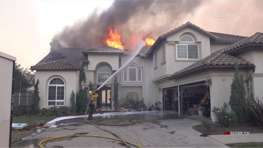
Social impacts involve public safety and the potential devastation from lives or homes being lost
during extreme wildfires. Canyon Fire 2 in October 2017 did not result in any fatalities;
however, there were 14 homes destroyed, 44 homes damaged, thousands of people evacuated,
and over 9,000 acres burned from the wind-driven event that was initiative from remaining
embers from a previous brush fire. As a result, the Anaheim City Council supported certain fee
assistance and accelerated permitting to assist homeowners with restoring their lives.
SECTION 4- Overview of Risks and Risk Drivers Related to Wildfires
As previously mentioned, a repository of wildfire-related risks from utility operations and/or
equipment sparking a wildfire were identified and prioritized based on the threat to the
community, core business impact, consequences, and risk mitigation path. The “bow-tie”
method illustrates this process.
13Figure 3. Wildfire “Bow-Tie” Risk Mitigation Chart
Impacts
Causes Key Risk Wildfires Potential
Drivers/Triggers involving APU Consequences
Equipment
Table 4 summarizes the analysis conducted to identify APU’s exposure to, and impacts from a
wildfire and to identify current controls and mitigations to reduce the significant risk of a
wildfire occurring. It is important to note that the below listed potential risk drivers/triggers are
an indication that a risk event could occur, but do not necessarily reflect actual conditions or
threatened conditions.
Table 4. Risk Mitigation for Wildfire Ignition
Risk- APU Equipment including Third Party Attachment Igniting a Wildfire
Potential Drivers Description of Impact Mitigation Measures and Programs
Topology Wildland areas with exposure to • Vegetation Management
overhead power lines. • Construction Standards
• Water infrastructure reliability improvements
to help protect homes near wildland areas
• Ensure availability of water in Walnut
Canyon Reservoir for water aircraft support
• Patrols of utility equipment and structures
Elevated wildfire Weather conditions plus topology • Construction Standards
conditions more conducive to the spread of a • Reclosers Blocking
wildfire. • Wildfire Cameras
• Pole Loading
• Threat Level Communications and Public
Outreach
Climate Change Expanding fire threat areas and • Inventory Assessment in the FTZ
more extreme weather conditions. • Vegetation Management
Contact by a Vegetation, metallic balloons, • Construction Standards
foreign object avian, vehicle accidents, for • Avian Deterrents
example, coming into contact • Conductor Spacing
with APU overhead electric • Undergrounding
facilities.
Failure of Electrical equipment containing • System Inspection
Equipment flammable material or potential • System Patrols
for arcing when operated in a
FTZ.
14Risk- APU Equipment including Third Party Attachment Igniting a Wildfire
Potential Drivers Description of Impact Mitigation Measures and Programs
Downed Energized electrical wires falling • System Inspection
Conductors and coming into contact with • System Patrols
including Third vegetation below. • Reclosers Blocking
Party attachments • Vegetation Management
• De-Energize Equipment
• Undergrounding
Energized lines Multiple energized lines in • Construction Standards
coming into contact with each other creating • Conductor Spacing
contact arcing and sparking in dry • De-energize Equipment
conditions.
Operational Automatic operations to re- • Reclosers Blocking
Procedures energize a line after an • Public Safety Power Shut-off
interruption or programmable • Notification to AF&R emergency operations
settings that de-energize during to determine necessity of activation of local
specific conditions. Emergency Operations Center (EOC) and
establishment of incident command
• Evacuation Assessment
• Initiate citywide communications and public
outreach
• Staffing of 311 Call Center to assist with
customer inquiries
Lack of When ignition is identified, a • Customer Support and Emergency Response
Coordinated well-coordinated response to coordination with local and regional first
Response suppression and de-energizing responders
lines to limit progression of the • Coordination with SCE
fire. • Staffing of EOC and inter-departmental
collaboration on traffic, emergency
management, and communications
The potential consequences if the risk drivers listed above were to occur and resulted in an
incident, in a “worse-case-scenario”, could include:
• Personal Injury to the public, employees, and contractors
• Damage to real and personal property
• Damage and loss of City of Anaheim owned assets and facilities
• Reliability impacts
• Reputational damage
• Claims and Litigation
As an overview of the WMP, the preventative strategies discussed further in the WMP are
mapped to these potential risk drivers in Table 5 and placed in one or more of the following
categories: (1) Situational Awareness, (2) Design and Construction, (3) Inspection and
Maintenance, (4) Operational Practices, and (5) Response and Recovery.
15Table 5. Categorization of APU Potential Wildfire Risk Drivers, and Corresponding Preventative
Strategy
Risk Driver Categorization Assessment/ Preventative Strategy
Topology Situational Awareness Section 5,6
Elevated Wildfire Condition Situational Awareness Section 5,6,7
Climate Change Situational Awareness Section 3
Contact by Foreign Object Design & Section 9(e)
Construction/Response &
Recovery
Failure of Equipment Design & Construction/ Section 9(b-d)
Inspection & Maintenance Section 10(a)
Downed Conductors including Design & Construction/ Section 9(b-d) Section 10(a)
Third Party attachments Inspection & Maintenance
Energized lines contact together Design & Construction Section 9(c,d)
Operational Procedures Operational Practices Section 10(a-e)
Lack of Coordinated Response Response & Recovery Section 11,12,13
SECTION 5 - Assessment of High Fire Threat in APU’s Electric Service
Territory
A statewide fire threat map was developed to delineate the boundaries to identify, evaluate, and
potentially adopt stricter fire-safety regulations that apply only to overhead power lines, electric
equipment, and communications lines located within those boundaries. The map was developed
by a peer group of utility personnel and fire safety professionals known as the Peer Development
Panel (PDP) with the oversight by an Independent Review Team (IRT) appointed by Cal-Fire
and the CPUC.
Tiered FTZs within the fire map boundaries are developed based on the Cal Fire “Very High Fire
Hazard Severity Zones” in Anaheim to prioritize the need to increase infrastructure resiliency to
mitigate the wildfire threat posed by electric infrastructure. APU and AF&R, with outreach to
Southern California Edison and the Orange County Fire Authority, developed the Anaheim FTZ
boundaries, Figure 4--Anaheim Public Utilities Fire Threat Map, which was reviewed by the
PDP and adopted by the IRT in September 2017. APU and AF&R review the map annually and
on as-needed basis to address any changes to the FTZs. The map was established based on
criteria for FTZ tiers listed in Table 6.
16Figure 4. Anaheim Public Utilities Fire Threat Map
Tier 2 Tier 3
Elevated Extreme
Tier 1
Low
Table 6. Tiered Fire Threat Zones in Anaheim
Zone Category Description
Tier 3 Extreme Typically wildland areas where exposure to overhead power
lines, the availability of water resources, and emergency
responder circulation routes affect response times to combat
wildland fires.
Tier 2 Elevated Elevated risk due to the vegetation, high voltage regional
transmission lines crossing the area, and adjacency to Tier 3
FTZs.
Tier 1 Low Well developed areas, typically with underground high voltage
circuitry.
Topography has a considerable effect on wildland fire behavior and on the ability of fire fighters
and their equipment to take action to suppress wildland fires. Due to topography, a fire starting
in the bottom of a canyon may expand quickly to the ridge top before initial fire responders can
arrive. Rough topography greatly limits road construction, road standards, and accessibility by
ground equipment. A relatively large portion of East Anaheim is covered by natural vegetation.
Of these different vegetation types, coastal sage shrubs, chaparral, and grasslands reach some
degree of flammability during the dry summer months and, under certain conditions, during the
winter months. For example, as chaparral gets older, twigs and branches within the plants die
and are held in place. A stand of brush 10 to 20 years of age usually has enough dead material to
produce fire spread rates about the same as in grass fires when the fuels have dried out. In severe
drought years, additional plant material may die, contributing to the fuel load.
17There will normally be enough dead fuel that has accumulated in 20 to 30-year old brush to give
fire spread rates about twice as fast as in a grass fire. Under moderate weather conditions that
produces a fire spread rate of one half foot per second in grass, a 20 to 30-year old stand of
chaparral may have a fire spread rate of about one foot per second. Fire spread in old brush (40
years or older) has been measured at eight times as fast as grass, at about four feet per second.
Under extreme weather conditions, the fastest fire spread rate in grass is 12 feet per second or
about eight miles per hour. Anaheim is relatively flat with the exception of the eastern portion of
Anaheim where the Wildland Urban Interface (WUI) presents greater risk of wildfire.
To manage surface fuel in the FTZ, AF&R manages the Brush Abatement Program which is
divided into three phases:
• Phase I Natural Brush Abatement- The use of goats to remove flash & invasive
fire fuels.
• Phase II Mechanical Brush Abatement- The use of machinery and tools to trim
existing trees and brush 10 from the ground, and remove dead and invasive trees
and shrub
• Phase III- To replant with native plants and shrubs to reestablish nature’s natural
fire break.
Within Anaheim’s boundaries there are four Tier 3 FTZs; these areas are exposed, generally
steep north facing slopes with coastal sage shrubs and mixed chaparral. Areas designated Tier 3
contain two sections of pole lines totaling approximately one mile, which is a small portion of
overhead 12 kV pole lines traversing the terrain which warrants the need for increased
infrastructure resiliency to reduce fire risk.
The first segment of overhead 12 kV line traverses a Tier 1 FTZ and a portion of the line crosses
into a Tier 3 FTZ along a narrow, private roadway that that makes it difficult for emergency
vehicles to access. The WMP was initially approved by City Council in 2018 that included a
recommendation to underground this segment of overhead line as part of the Underground
Conversion Program and in the interim, apply the preventative and operational strategies
outlined in this WMP to mitigate fire risk. This segment is subject to potential power shut-offs
until future undergrounding occurs. A community meeting was held in October 2018 to inform
the residents that 8 households could be affected from a Public Safety Power Shutoff (PSPS)
event, but that mitigation measures were taken and future undergrounding was planned. The
undergrounding project was approved by City Council resolution, and it included
telecommunication providers to eliminate the poles completely; however, AT&T has declined to
underground this segment at its expense through its Rule 32A citing that this roadway does not
meet the definition of an eligible project as currently defined, and APU is therefore seeking
CPUC consideration for AT&T’s full participation and funding of this important segment to
reduce wildfire risk and improve vehicle accessibility for fire and utility trucks. Construction to
underground this line segment commenced in summer 2020, with the expectation of completion
by summer 2021.
The second segment is an overhead 12 kV line that traverses through a natural park and has
varying elevations of terrain that would be highly disruptive to the natural setting if underground
excavations took place, and would be difficult to access if underground equipment were to be
installed. The construction of this line was reinforced for increased resiliency with the
18installation of 27 ductile iron poles and increased spacing between conductors. To preserve the
natural habitat of the woodpecker birds in this area, some wood poles were left standing as
perches with all electric conductors and equipment detached. Additionally, this segment is a
circuit-tie and does not serve customers and is therefore de-energized in its normal status. The
protocol has been established for visual inspection of this line prior to re-energization, and to use
the line for reliability purposes including emergency power restoration when environmental
conditions warrant.
Seven small segments of 12 kV overhead line traverse through areas designated Tier 1 and
adjacent to Tier 2 FTZ. Vegetation clearance is currently maintained following the vegetation
management practices (see Section 9), and due to the moderate risk associated with Tier 2 FTZ,
the line will be patrolled annually to ensure those clearances are maintained. APU partnered
with Anaheim Fire & Rescue to apply for grant funding to help offset the cost and accelerate the
undergrounding of these lines. In February 2021, APU received approval for Hazard Mitigation
Grant Program (HMGP) funds from the Federal Emergency Management Agency (FEMA) for
phase 1 design of undergrounding these high voltage electrical lines within the HFTZ, and
includes the segment in the natural park where undergrounding around the park is being
evaluated. The design phase is expected to be completed in 2023 at which time FEMA will then
consider approval of the Phase 2 construction portion, allowing undergrounding construction to
commence in late 2023.
Tier 1 FTZ areas are categorized as low risk, as the areas are served through predominantly
underground lines. These areas are well developed and have access to fire hydrants, with
roadways that are accessible to fire and utility personnel.
Also located within the Tier 1-3 FTZ are Southern California Edison’s (SCE) high voltage
overhead 500 kV transmission lines which serves as one of several interconnection paths for
Anaheim to the regional power grid. SCE is subject to regulatory oversight by the CPUC, who
will review and approve SCE’s wildfire mitigation plan to address its transmission assets,
including the areas that pass through Anaheim. APU coordinates with SCE on situational
awareness of fire conditions, as well as operational activities that may include SCE de-energizing
the high voltage transmission lines. The impact to Anaheim is mitigated since there are multiple
transmission lines that serve Anaheim.
SECTION 6- Asset Inventory in Fire Threat Zones (FTZ)
Overhead electrical infrastructure located within the FTZ are listed in Table 7. Additionally,
resources including water pumps, communication stations, and customers with medical needs are
considered when planning operational strategies to minimize risk of ignition sources by de-
energizing electric lines as an example.
19Table 7. Fire Threat Zone Assets and Critical Facilities
Tier 3 Tier 2 Tier 1 APU
Source Asset
(Extreme) (Elevated) (Low) Total
Circuit Miles 1.06 .04 1.94 394
APU Electric Poles 38 7 79 17,100
Distribution in
FTZ Overhead
10 0 26 7,250
Transformers
SCE Electric Circuit Miles 2.60 0.95 0
Transmission in
FTZ Towers 20 6 0
APU Water
Pump
Treatment in 2 0 0 2
Equipment
FTZ
Communications Cell tower 0 0 0
Critical Care Hospitals 0 0 0
Community
Public 0 0 0
Centers
20SECTION 7- Overview of Preventative Strategies and Programs
Table 8. Preventative Strategies and Programs
Situational/Conditional Awareness
Collaboration with AF&R, Fire Safe Councils and OCFA in preparation for RFW and SAWTI events.
Fire cameras installed in Anaheim’s Tier 3 FTZ and connected to the regional network AlertWildfire.org
Weather monitoring stations installed in FTZ and network access for local weather station data.
Training for AF&R Dispatch Center and APU Operators in fire camera view and operations.
Daily monitoring and reporting of elevated fire conditions including RFW and SAWTI.
On-site visual inspection by APU troubleshooter and CERTS during elevated conditions.
Training for APU Operations Reclosers Disabling.
Training for APU Operations De-energize/Restore protocol and communications.
Design and Construction
Installation of Fire Monitoring Cameras in the FTZ.
Installation of Weather Monitoring Stations in the FTZ.
Modified Construction Standards for FTZ.
Wood to Ductile Iron pole replacement.
Concealed lightning arrester replacement.
Insulated covers on equipment mounting brackets.
Increase overhead wire spacing.
Increased wind loading for pole strength and integrity.
Installation of avian diversion equipment.
Undergrounding electric lines in FTZ.
Inspection and Maintenance
Vegetation Management- Line Clearance
Surface fuel management
Vegetation tracking and recording
Detailed distribution overhead and underground line and infrared thermography inspection
Distribution wood pole intrusive testing
Visual inspection and infrared thermography of distribution substations
Substation equipment oil sampling
Operational Practices
Overhead Distribution line patrols
Disabling reclosing during elevated fire conditions
Independent fiber-optic communication network
De-energized power lines through Oak Canyon Nature Center
Response and Recovery
Wildfire Mitigation Response Procedures- Operation and communication protocols including PSPS
Communication strategy for de-energize/restore response.
Emergency Response planning for Stakeholder support during a PSPS.
Field Operations recovery procedures
Post event customer support and protection services
Modifications to policies, practices, and procedures
Waiver of electric and water service connection fees
Waiver of electric and water design/engineering, plan checks, and inspection fees
Impacted customer payment extensions, payment plans
Irrigation controllers provided at no cost to extend longevity of landscaping.
21SECTION 8 - Situational Awareness
In Southern California, the period for active fire conditions can exist year-round; however,
conditions contributing to a higher risk of a fire igniting and spreading is attributed to the amount
of dry fuel sources, high winds, relative low humidity, and dry lightning conditions. APU
collaborates with multiple stakeholders including, but not limited to, AF&R, the APU Water
Division, the National Weather Service, and adjacent electric utilities including SCE and San
Diego Gas and Electric (SDG&E) to leverage situational awareness, camera networks, web-
based real-time monitoring data from local weather stations, and fire condition warning systems
that gauge fire threat conditions so APU can mobilize personnel and take specific actions to
mitigate a higher fire threat.
AF&R provides daily assessment of conditions classified as Normal, Elevated, Extreme, and Red
Flag Warning conditions for mountainous (East Anaheim) areas. A Red Flag Warning (RFW) is
issued for weather events which may result in extreme fire behavior that will occur within 24
hours. A RFW is typically issued when relative humidity is at or below fifteen percent (15%)
and sustained winds are expected to reach twenty-five miles per hour (mph) or higher and/or
wind gusts exceed 35 mph for six or more hours. Also, lightning under dry conditions will
typically trigger a RFW. At the onset of the RFW for the mountainous areas, AF&R notifies
APU and deploys fire watchers for on-site assessment of conditions. The RFW for the
mountainous areas most closely correlate with the Anaheim Tier 3 FTZ and where utility
overhead infrastructure is located.
In conjunction with the RFW, another early warning system is the Santa Ana Wildfire Threat
Index (SAWTI), which was developed through collaboration with Cal-Fire, UCLA, the National
Forest Services, the National Weather Service, SDG&E, and the Desert Research Institute, that
classifies the large fire threat potential from Marginal to Extreme based on the likelihood of a
catastrophic wildfire fueled by high winds. High winds contribute to increased dry fuel source,
but also can cause power lines to come into contact with each other and produce a spark which
potentially can cause a fire ignition. APU monitors and reports the SAWTI for Zone 2 -
Orange/Inland Empire on a daily basis to key personnel.
Forecasts and weather indexes are early-warning tools to proactively prepare for events;
however, real-time monitors tracking the changing dynamics of an event can refine key decisions
impacting response times. High resolution cameras and weather stations are utilized in Anaheim
for this purpose.
AF&R and APU jointly evaluated a regional network of fire cameras that is being deployed in
the FTZ to provide high-resolution video, near-infrared capabilities, and the ability to zoom into
areas to more quickly identify ignition points. Because wildfires spread rapidly in windy
conditions, the ability to recognize and respond expeditiously can make a significant difference
in saving lives and properties.
AF&R and APU joined with University of California San Diego-Scripps (UCSD) to become part
of this regional network of fire cameras and to include locations in Anaheim through an
agreement approved by Anaheim City Council on May 14, 2019. This allows access to the
larger regional system that spans from San Diego and Orange Counties, and further north to
Central California, and into Nevada. This regional network is owned and managed by UCSD-
22Scripps, with network partnerships including SDG&E, SCE, Orange County Fire Authority
(OCFA) and Cal-Fire. This network provides AF&R Dispatchers and APU Operators with the
ability to view camera images, and provides additional capabilities to AF&R to remotely control
the cameras and more quickly verify an ignition while environmental conditions are being
monitored in real time. AF&R can more quickly validate 911 calls reporting a fire by first using
the cameras and then deploy the necessary resources based on the visual information. These
cameras are now part of the Alertwildfire.org regional public access network of high resolution
cameras used by fire agencies as a topographical visual tool for scouting fires.
The link for public access of regional network of fire cameras is: http://www.alertwildfire.org/.
Figure 5 (a) Alertwildfire.org portal
Figure 5 (b) High Resolution Camera Installation and Camera Image Overlooking
Anaheim
23Figure 5 (c) Anaheim Camera Image of 91/241 Freeway Interchange
Anaheim strategically placed one of its Pan-Tilt-Zoom (PTZ) cameras to capture real-time
situational awareness in Gypsum Canyon, the originating location of the 2017 Canyon Fire 2.
This camera was recently used by AF&R Dispatch to visually capture movement of the 2021
Blue Ridge Fire. A second camera was installed at a substation to provide a different easterly
vantage point. Cameras at two additional locations facing south have been installed and visually
captured progress of the Orange County 2021 Silverado Fire. Four camera locations in total are
complete and APU is reviewing two additional locations with AF&R to possibly coordinate with
UCSD Scripps for installation.
Figure 5 (d) Camera locations that provide strategic vantage points of Anaheim FTZ’s
Gypsum
Deer
Sierra
Pleasants
Santiago
24The network provides access to existing cameras on locations that provide strategic vantage
points along Santiago Peak, Pleasants Peak, and Sierra Peak in addition to the Anaheim cameras
viewing Gypsum Canyon and Deer Canyon for a 360 degree view of the FTZ.
Weather stations that gauge wind conditions and humidity levels are located at the Orange
County Water District (OCWD) facility, Fairmont Substation, and in 2020 at the Lenain Water
Treatment facility within a Tier 3 FTZ and at the Yorba Linda pumping station in East Anaheim.
The data is used by AF&R and APU to direct resources and make operational decisions based on
the measured peak wind gust. In addition to the fire camera network, a network of local weather
station data is publicly available through the National Weather Service /NOAA Weather and
Hazards Data Viewer. Within Anaheim, there are approximately 9 weather stations through
partnerships with SCE, the California Air Resources Board (CARB), and the Citizen Weather
Observer Program (CWOP).
The Alertwildfire.org network cameras and weather stations are monitored by the AF&R
Dispatchers and utilized as another real-time data source for monitoring fire threat conditions,
and where appropriate, warrant APU operational actions that are discussed in this WMP. The
fire cameras proved to be very useful to AF&R in October 2019 during the Contempo Fire that
ignited in the FTZ in East Anaheim, south of the 91 freeway near Coal Canyon. The recently
installed cameras were used to help verify ignition, direct aircraft, and position ground crews to
keep the wildfire from spreading and was contained to only 5 acres. The illustration below
depicts the image captured by AF&R Dispatch of that wildfire from the cameras.
25Figure 5 (e) Anaheim Camera Image of Contempo Wildfire 10-26-2019
SECTION 9- Preventative Strategies for Building Infrastructure Resiliency
The goal of the WMP is to minimize the risk of electric infrastructure being a contributing factor
to the ignition of a wildfire. A prudent approach is taken to consider and, where appropriate,
implement changes and improvements to physical infrastructure that are practical preventative
measures in construction and maintenance practices to meet that goal. APU utilizes established
guidelines and industry best practices for safe design and construction of the electric distribution
system, using resources such as the CPUC General Orders (GOs). GOs outline safe clearances,
integrity of construction, and maintenance requirements to achieve a level of infrastructure
resiliency to withstand elevated to extreme environmental conditions.
A. Vegetation Management
For the safety and reliability of service where overhead conductors traverse trees and vegetation,
APU performs vegetation management activities consistent with the guidelines outlined in GO
95 – Rules for Overhead Electric Line Construction, Section III - Minimum Allowable
Clearances -Extreme and Very High Fire Threat Zones in Southern California, to establish
necessary and reasonable clearances between the vegetation and the energized conductors in a
Tier 3 FTZ. GOs are technical requirements established by the CPUC for investor owned
utilities and are utilized by APU as best industry practice for utility operation and construction.
Additionally, dead or rotten trees and brush at risk of falling into energized conductors are
26inspected, identified, and removed as recommended by the Certified Arborist and Certified
Power Line Clearance tree trimming Supervisor on staff with Anaheim, who oversees the
vegetation management contractors. Clearances are increased around overhead power lines in
high risk fire areas where the combination of high wind potential and dry vegetation may
increase the risk of fire ignition. APU contractors perform power line clearance tree trimming
for approximately 13,000 trees annually across the City, with approximately 5% of those trees
within the HFTZ. Trees within the HFTZ are prioritized for trimming to be completed prior to
summer before extreme temperatures begin to elevate wildfire risk. The definitions of Extreme
and Very High Fire Threat Zones in Southern California are contained in GO 95 Rule 21.2, and
reference the adopted CPUC Fire-Threat Map which is consistent with the AF&R adopted CAL-
FIRE map.
Studies of the most recent wildfires indicate there are approximately ten species of trees that
have been responsible for 75% of the past fire ignitions in California. Anaheim tracks the
location, species, condition, and trimming schedule for trees near power lines in the Tier 3 FTZ
to maintain a defensible space. The attributes of the tree and GPS coordinates are archived in
Geographic Information System (GIS) mapping, and annual inspections and trimming
appropriate for the growth pattern of that species is recorded. Figure 6 depicts the attributes
recorded for each tree within the FTZ.
27You can also read