WETLAND RESTORATION PLAN FOR A PROPOSED BOAT HARBOUR DEVELOPMENT AT KEEPA ROAD, WHAKATĀNE
←
→
Page content transcription
If your browser does not render page correctly, please read the page content below
WETLAND RESTORATION PLAN FOR A
PROPOSED BOAT HARBOUR DEVELOPMENT
    AT KEEPA ROAD, WHAKATĀNE

                                   R4797h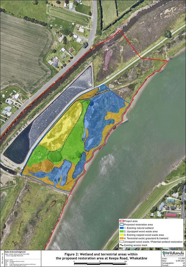
WETLAND RESTORATION PLAN FOR A
     PROPOSED BOAT HARBOUR DEVELOPMENT
                   AT KEEPA ROAD, WHAKATĀNE

Contract Report No. 4797h
January 2022

Project Team:
William Shaw - Field evaluation and report author
Mitchell West - Field evaluation and report author
Richard Pender - Report author

Prepared for:
Te Rāhui Lands Trust
C/- Secretary
46 Hall Street
Kawerau 3127

               WHAKATANE OFFICE: SUITE 4, 108 THE STRAND, WHAKATANE 3158, Ph 07-308-9791
                      HEAD OFFICE: 99 SALA STREET, P.O. BOX 7137, TE NGAE, ROTORUA
            Ph 07-343-9017; Fax 07-343-9018, email ecology@wildlands.co.nz, www.wildlands.co.nz
CONTENTS
1.   INTRODUCTION                                                                              1

2.   PROJECT GOALS AND OBJECTIVES                                                              2
     2.1   Project goals                                                                       2
     2.2   Objectives                                                                          2

3.   DETAILS OF ACTIVITY SITE AND NATURAL WETLAND                                              2
     3.1   Physical address of the site of the activity                                        2
     3.2   The names of the owners of the site                                                 2
     3.3   The contact details for the owners                                                  4
     3.4   The legal description of the site, including the estate or interest held by
           the owners and any legal status or designation that applies to the site             4
     3.5   Map showing the location and boundaries of the natural wetland                      4
     3.6   Details of the legal status of the natural wetland under any enactment
           or plan                                                                             4
     3.7   Details of any management partners or key stakeholders involved in
           the restoration plan                                                                4

4.   FEATURES AND VALUES OF NATURAL WETLAND                                                    6
     4.1   Type of natural wetland                                                             6
     4.2   Vegetation in the natural wetland                                                   6
     4.3   Hydrology of the natural wetland                                                    9
           4.3.1      Water sources and flows (for example, streams, rivers,
                      seeps, or solely rain)                                                  9
           4.3.2      Water levels                                                            9
           4.3.3      Modifications                                                           9
     4.4   Types of soil in the natural wetland                                               9
     4.5   Artificial features in the natural wetland                                        10
     4.6   Fauna known to use the natural wetland or the surrounding area                    10
           4.6.1      Avifauna                                                               10
           4.6.2      Fish                                                                   11
           4.6.3      Introduced pest mammals                                                11
     4.7   Special features of the natural wetland                                           11

5.   ISSUES WITH THE NATURAL WETLAND                                                          11
     5.1   Description of the current state and condition of the natural wetland             11
     5.2   Discussion of the threats to the natural wetland and the opportunities
           for restoration of its features and values                                        12

6.   MANAGEMENT OBJECTIVES FOR NATURAL WETLAND                                                12
     6.1   Legal status under any enactment or plan                                          12
     6.2   Existing or required resource consents or agreements with landowners
           or other relevant persons                                                         13

7.   OPERATIONAL DETAILS FOR ACHIEVING MANAGEMENT OBJECTIVES                                  13
     7.1   Overview of operational details and actions                                       13
     7.2   Timelines for the activities and the persons responsible for resourcing
           and delivering them:                                                              16
     7.3   Scale plans showing the operational areas                                         17
     7.4   Planting                                                                          17
           7.4.1    Diagram showing the general areas for planting                           17
           7.4.2    Species to be used within specific areas                                 17
           7.4.3    Spacing of the plants                                                    18

                     © 2022                                            Contract Report No. 4797h
7.4.4 Sources of the plants 18
7.4.5 Approach to releasing the plants 18
7.5 Vegetation (or substrate) to be removed, including species and
methods of removal (for example, cutting, digging, or spraying) 18
7.6 Any substrate to be removed or earthworks to be undertaken 19
7.6.1 Earthworks to remove existing wood waste 19
7.6.2 Earthworks to restore former wetland habitat 19
7.7 Any machinery to be used and the purpose of its use 19
7.8 Description of the approach to water management 20
7.8.1 Any changes to water levels or movement of water during
and after the restoration works 20
7.8.2 If water will be dammed or diverted 20
7.9 Approach to managing erosion and sediment to be used during all of
the works 20
7.10 Pest animal control to be carried out to enhance fauna habitat values 21
7.10.1 Pest animals present and control requirements 21
7.10.2 How often, and for how many years, the pest animal control
will be carried out 21
7.10.3 Methods by which the animal pest control will be carried out 22
7.11 Pest plant control actions 22
8. REVIEW AND REPORTING 23
8.1 Timelines for reporting progress 23
8.2 How any requirement to report under a resource consent will be met 23
ACKNOWLEDGMENTS 23
REFERENCES 23
APPENDIX
1. Site photographs 25
Reviewed and approved for release by:
_______________________
W.B. Shaw
Director/Lead Principal Ecologist
Wildland Consultants Ltd
© Wildland Consultants Ltd 2022
This report has been produced by Wildland Consultants Ltd for Te Rāhui Lands Trust. All copyright in
this report is the property of Wildland Consultants Ltd and any unauthorised publication, reproduction,
or adaptation of this report is a breach of that copyright.
© 2022 Contract Report No. 4797h1. INTRODUCTION
Through a transformational partnership, Te Rāhui Lands Trust (previously Rangitāiki
Lot 28B No. 22 Ahu Whenua Trust), Te Rūnanga o Ngāti Awa, Ngāti Awa Group
Holdings Limited and the Whakatāne District Council (WDC), together with the
Provincial Growth Fund, propose to develop a ‘fit for purpose’ boat harbour, providing
approximately 130 berths, on Māori freehold land at 2 Keepa Road, Whakatāne, legally
described as Part Allot 28B 22 Rangitaiki PSH (the site). The project, known as
Te Rāhui Herenga Waka Whakatāne, will address the current demand for additional
commercial berthage in Whakatāne and will offer vessels protection from the dynamic
river environment while at the same time providing long-term and holistic benefits to
the land, the beneficiaries of the Trust, Ngāti Awa and the Whakatāne District.
Te Rāhui Herenga Waka Whakatāne is to be constructed on land and connected to the
Whakatāne River estuary through a purpose-built access channel. The channel,
approximately 30 metres wide, is to be constructed within the Bay of Plenty Regional
Council’s Kopeopeo Canal flood overflow channel which passes through the Scenic
Reserve and flows into the river. The access channel will also bisect the Regional
Council’s flood stopbank, however the boundary of the wet environment will be built
to match the height of the stopbank to maintain the existing level of flood protection.
The site and wider area east of the stopbank has a long history of modification and has
previously been used as a dumping ground for wood waste material/timber peelings
from the Whakatāne Mill. While this activity ceased some time ago, the material
remains in situ. Material removed from the site will be assessed to ensure it is suitable
to be treated as cleanfill and will be disposed of at pre-determined disposal sites
throughout the region. Where material is not suitable for re-use, it will be transported
to an authorised disposal facility. Therefore, the development of the site will enable a
wider remediation of the area of ‘contamination’ from the Mill’s waste, in a manner
that restores the mauri of the whenua, in accordance with the landowners’ aspirations.
Wildland Consultants (2019a) produced a preliminary ecological assessment for
potential boat harbour sites in the harbour/river system and this was followed by an
initial assessment of the site between Keepa Road and the Whakatāne estuary (Wildland
Consultants 2019b), and a more detailed assessment in 2021 (Wildland Consultants
2021). The 2021 report identified the potential for the development of a mitigation plan
to address the loss of indigenous vegetation and habitats during the construction of
Te Rāhui Herenga Waka Whakatāne. This plan would be submitted as part of a wider
resource consent application for the development of the boat harbour.
This report provides an ecological restoration plan for an area of saltmarsh and
associated dryland areas at the northern end of the wider development site, immediately
adjacent to the Whakatāne River. This plan addresses relevant requirements in the
National Policy Statement for Freshwater Management 2020 (Ministry for the
Environment 2020), and identifies the ecological values and threats that are present
within the proposed restoration area, outlines appropriate management actions, and
provides a timeline for the implementation of restoration activities.
© 2022 1 Contract Report No. 4797h2. PROJECT GOALS AND OBJECTIVES
2.1 Project goals
Overarching project and management goals are needed to provide guidance for the
development and implementation of the restoration plan for the proposed restoration
area:
• To fulfill resource consent requirements to enable the implementation of the
Te Rāhui Herenga Waka Whakatāne project.
• Protect and enhance the ecological integrity of the proposed restoration area by
implementing the management actions identified within this restoration plan.
• Enhance the mauri of the site for the benefit of members of the Te Rāhui Lands
Trust and the wider public.
2.2 Objectives
• To identify the current ecological values and threats to species and habitats within
the site, and implement management actions to enhance the values and manage the
threats on an ongoing basis.
• Undertake earthworks and implement ecological restoration to convert areas of
the site that currently comprise organic and inorganic waste material, and exotic
plants and fauna to wetlands and associated terrestrial habitats that primarily
comprise indigenous species.
3. DETAILS OF ACTIVITY SITE AND NATURAL WETLAND
3.1 Physical address of the site of the activity
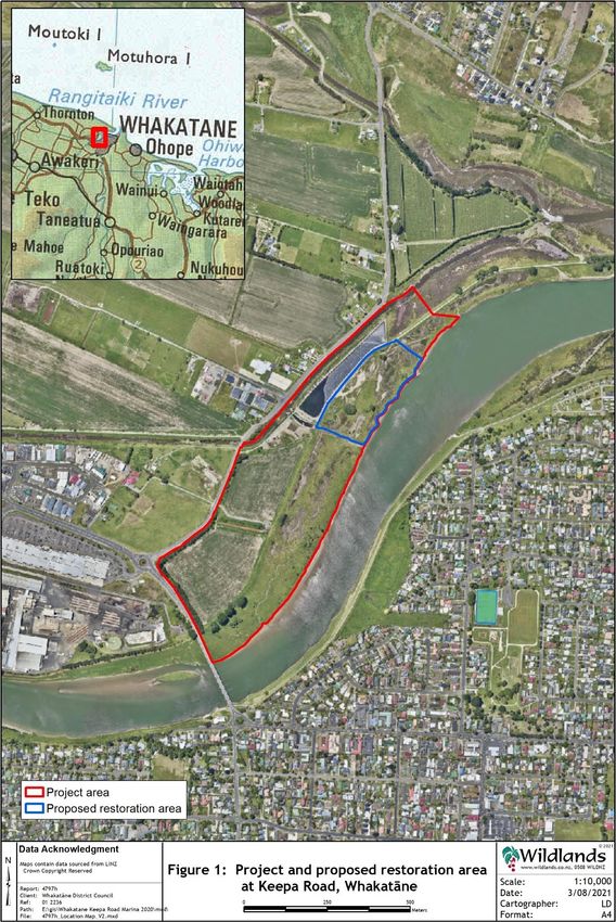
The proposed ecological restoration area (5.8 hectares) is located at 44C Keepa Road
on the western side of the Whakatāne River, downstream of the Landing Road Bridge
and opposite Whakatāne Township (Figure 1).
3.2 The names of the owners of the site
Part Allot 28B 22 Rangitaiki PSH is owned by over 1,100 individuals of Ngāti Awa
descent. Te Rāhui Lands Trust (previously Rangitāiki Lot 28B No 22 Ahu Whenua
Trust) represent the interests of these landowners in relation to the proposed restoration
works outlined in this document.
© 2022 2 Contract Report No. 4797h© 2022 3 Contract Report No. 4797h
3.3   The contact details for the owners

      Given the large number of individual landowners of Part Allot 28B 22 Rangitaiki PSH,
      Te Rāhui Lands Trust are responsible for liaising between the relevant stakeholders and
      the landowners of Part Allot 28B 22 Rangitaiki PSH. Te Rahui Lands Trust contact
      details are as follows:

      Te Rāhui Lands Trust
      C/- Secretary
      46 Hall Street
      Kawerau 3127
      Attention: Dayle Hunia

3.4   The legal description of the site, including the estate or interest held by the
      owners and any legal status or designation that applies to the site

      The site is Māori freehold land legally described as Part Allot 28B 22 Rangitaiki PSH.

3.5   Map showing the location and boundaries of the natural wetland

      See Figure 2.

3.6   Details of the legal status of the natural wetland under any enactment or plan

      The site is part of the wider Whakatāne Estuary which has been identified in the
      Operative Whakatāne District Plan (Whakatāne District Council 2017) as a Significant
      Indigenous Biodiversity Site (SIBS BS138A); Whakatāne Estuary (c.149 ha). The
      SIBS contains a range of habitats including intertidal flats, alluvial plains, estuarine
      channels, and wetlands. The site is also within an Indigenous Biological Diversity Area
      (IBDA A44; Whakatāne Estuary) recognised in the Bay of Plenty Regional Coastal
      Environment Plan.

      Part of the site is within the Keepa Road Scenic Reserve, administered by the
      Department of Conservation. There are significant overlaps between the Scenic
      Reserve, the SIBS, and the IBDA sites.

3.7   Details of any management partners or key stakeholders involved in the
      restoration plan

      Key stakeholders involved in the proposed restoration plan include:

      •   Te Rāhui Lands Trust
      •   Te Rūnanga o Ngāti Awa
      •   Ngāti Awa Group Holdings Limited
      •   Whakatāne District Council (WDC)
      •   Department of Conservation
      •   Bay of Plenty Regional Council

                       © 2022                  4                       Contract Report No. 4797h
© 2022 5 Contract Report No. 4797h
4. FEATURES AND VALUES OF NATURAL WETLAND
This section provides a description of the features and values of the natural wetland that
are relevant to a restoration plan, including the following information:
4.1 Type of natural wetland
The area forms a mosaic of saltmarsh and associated dryland habitats at the northern
end of the wider development site, immediately adjacent to the Whakatāne River.
Estuarine wetlands at the site contain brackish water and are fed either from the flood
overflow outflow from the Kopeopeo Canal (freshwater) or from the Whakatāne River,
particularly during high tides.
4.2 Vegetation in the natural wetland
The proposed restoration area features several indigenous and exotic dominated
vegetation types occurring on terrestrial and wetland environments. Several pest plant
species common to the Bay of Plenty region are scattered throughout the area.
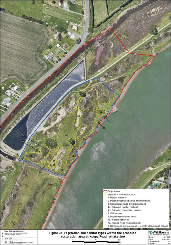
Eight vegetation and habitat types identified by Wildland Consultants (2019b) are
located within the proposed restoration area, and are described below and mapped in
Figure 3.
1. Raupō reedland
Raupō (Typha orientalis) is dominant with small local areas of sea rush (Juncus
kraussii var. australiensis), kukuraho (Bolboschoenus fluviatilis), and oioi
(Apodasmia similis). Scattered marsh ribbonwood (Plagianthus divaricatus) is
present throughout. A few small areas of Isolepis cernua are present on the
margins of estuarine channels. Local pampas (Cortaderia selloana) and
ti kouka (Cordyline australis) are present. Localised areas of rank grassland
also occur within the vegetation type.
2. Marsh ribbonwood scrub and shrubland
Marsh ribbonwood reaching between 1-1.5 metres tall. Local areas of sea rush,
oioi, kukuraho, and rank exotic grasses. A few local patches of pampas,
Japanese honeysuckle (Lonicera japonica), and exotic shrubs such as gorse
(Ulex europaeus).
3. Sea rush rushland and oioi rushland
Small areas are dominated by sea rush but smaller areas of oioi are also present.
Local areas of kukuraho and rank exotic grassland is also within the vegetation
type.
© 2022 6 Contract Report No. 4797h4. Estuarine mudflat and channels
Two sub-types are present:
4a Estuarine mudflat (natural)
Intertidal areas that primarily comprise mudflats but contain occasional
plants of sea rush, Isolepis cernua and kukuraho.
4b Estuarine channel (excavated)
The main example is the large channel excavated for flood overflows from
the Kopeopeo Canal. A small section has also been excavated on the
southern edge of the proposed restoration area.
5. Crack willow treeland
A small crack willow (Salix fragilis) stand as well as individual crack willow
trees (c.6-8 metres tall) occur on the banks of the Whakatāne River over a
ground-cover mostly comprising exotic grasses.
6. Poplar (Populus sp.) treeland and poplar trees
Scattered poplar trees (Populus sp.; c.10-15 metres tall) are present in parts of
the proposed restoration area. These trees occur over a ground-cover mostly
comprising rank exotic grasses.
7. Mosaic of tall fescue, cocksfoot, kikuyu, and ripgut brome grassland
This type is present in all the non-woody and wetland areas east of the stopbank.
Kikuyu and tall fescue are abundant with almost a complete monoculture in
many places, with scattered creeping buttercup (Ranunculus repens), broad-
leaved dock (Rumex obtusifolius), lotus (Lotus pedunculatus), narrow-leaved
plantain (Plantago lanceolatum), California thistle (Cirsium arvense), Chinese
mugwort (Artemisia verlotiorum), and purpletop (Verbena bonariensis) also
present.
A few small patches of abundant saltwater paspalum are present in areas with
some estuarine influence. The channels that pass through this type are steep-
sided (1-2 metres tall) and are usually dominated by tall fescue and kikuyu.
Local plants and patches of pampas, gorse, and Japanese honeysuckle are also
present. A c.2 metres tall scarp is present along the eastern margin of this
vegetation type, adjacent to the Whakatāne River. A few small patches of
kukuraho are present alongside the scarp edge. This type also includes grass-
dominated vegetation on the stopbank, which is almost entirely kikuyu.
© 2022 7 Contract Report No. 4797h© 2022 8 Contract Report No. 4797h
This type occurs on two landform types within the proposed restoration area:

              7a.    ‘Natural’ landform (1.1 hectares)
              7b.    Historic wood waste material (0.8 hectares)

      8.      Bare ground and grassland - recently cleared and capped (1.1 hectares)

              An area of contaminated soils that have been capped as part of remediation
              works that is currently mostly bare ground and exotic grasses and herbs.

4.3   Hydrology of the natural wetland

      The proposed restoration area contains a mix of terrestrial and wetland habitats
      (Figure 2).

      4.3.1     Water sources and flows (for example, streams, rivers, seeps, or
                solely rain)

                Estuarine wetlands at the site contain brackish water and are fed either from
                the flood overflow outflow from the Kopeopeo Canal (freshwater) or from
                the Whakatāne River, particularly during high tides.

      4.3.2     Water levels

                At the time of the site visits, water in the wetland had an estimated depth of
                5-50 centimetres. There is likely to be seasonal variation in the water levels
                of the natural wetland as well as tidal variation, including spring and neap
                tides.

      4.3.3     Modifications

                The overflow channel for the Kopeopeo Canal is located along the southern
                boundary of the proposed restoration area inside the overall project area. A
                smaller excavated drainage channel exists perpendicular off of the Kopeopeo
                overflow channel, and is c.50 metres in length and approximately orientated
                north to south. A stop bank that also provides four-wheel drive vehicle and
                public access runs along the western edge of the proposed restoration area,
                in a roughly north-south orientation.

4.4   Types of soil in the natural wetland

      The site is located on young (
4.5 Artificial features in the natural wetland
The proposed restoration area has several artificial features present in terrestrial areas.
An existing four-wheel drive access track runs along the western edge of the proposed
restoration area that partially bisects the Northwestern corner of the area. Powerlines
also run along the western boundary of the site, and the overflow channel for the
Kopeopeo Canal is located along the southern boundary of the proposed restoration
area. No artificial features including roads, electricity lines or buildings are located
within the area of existing natural wetland.
4.6 Fauna known to use the natural wetland or the surrounding area
4.6.1 Avifauna
A list of avifauna recorded at the site during the field visit on 20 June 2019 is presented
in Wildland Consultants (2019b). Twenty-three bird species were recorded, including
16 indigenous species and seven introduced species.
Six of the species observed during the site survey have a threat ranking in Robertson
et al. (2017):
• Kāruhiruhi/pied shag (Phalacrocorax varius varius): At Risk Recovering.
• Kōtuku-ngutupapa/royal spoonbill (Platalea regia): At Risk-Naturally
Uncommon.
• Little black shag (Phalacrocorax sulcirostris): At Risk-Naturally Uncommon.
• Mātātā/North Island fernbird (Bowdleria punctata vealeae): At Risk-Declining.
• Taranui/Caspian tern (Hydroprogne caspia): Threatened-Nationally Vulnerable.
• Tarāpunga/red-billed gull (Larus novaehollandiae scopulinus): At Risk-
Declining.
All of the above species were also recorded in the survey in October 2020.
Mātātā/fernbird were heard calling regularly (one bird was seen) in the wetland in June
2020 and in October 2020, with pairs of birds calling. In 2019, it was estimated that at
least 8-10 mātātā/fernbird were present throughout the raupō and saltmarsh habitat.
Key threats to mātātā/fernbird include wetland drainage, land conversion to pasture and
other land uses, and predation by introduced mammals (Miskelly 2013). The network
of wetlands along the lower Whakatāne River provide significant habitat for this
species. Pukeko were abundant in the wetland, but are not of conservation concern.
Other wetland species that could be present or utilise the wetlands on an itinerant basis
include matuku/Australasian bittern (Botaurus poiciloptilus; Threatened-Nationally
Critical), mohopereru/banded rail (Gallirallus philippensis assimilis; At Risk-
Declining), and puweto/spotless crake (Porzana tabuensis tabuensis; At Risk-Declining),
all of which have been recorded in other wetlands along the Whakatāne River.
© 2022 10 Contract Report No. 4797h4.6.2 Fish
Refer to Wildland Consultants (2021) for an overview.
Mitchell (1990) surveyed inanga/whitebait (Galaxias maculatus; At Risk-Declining)
spawning sites in the Whakatāne River in 1988. Spawning was found further upstream,
on the other side of the Whakatāne River, amongst tall fescue, similar to river margin
habitat in the project area. Another spawning site is known to be present further
upstream (A. Suren, BOPRC, pers. comm., and K. Hughes, pers. comm.) in the vicinity
of the entrance to Awatapu Lagoon. It is also possible that there are other spawning
sites.
4.6.3 Introduced pest mammals
The natural wetland and surrounding area will contain the typical suite of terrestrial pest
animals that are present on mainland areas of New Zealand. These include feral and
domestic cats, Norway rats, ship rats, mice, hedgehogs, and mustelids (ferrets, stoats,
and weasels).
4.7 Special features of the natural wetland
The site of the proposed restoration area is within the rohe of Ngāti Awa and is
immediately adjacent to a marae on Keepa Road: Te Hokowhitu A Tu. The Whakatāne
River and associated wetlands are of very considerable significance to Ngāti Awa and
their hapū. These wetlands were previously part of a very large wetland complex that
extended across the Rangitāiki Plains, and was a highly valuable source of kai and other
resources for Ngāti Awa.
The site is part of the wider Whakatāne Estuary which has been identified in the
Operative Whakatāne District Plan (Whakatāne District Council 2017) as a Significant
Indigenous Biodiversity Site (SIBS site #138A); Whakatāne Estuary (c.149 ha). The
SIBS contains a range of habitats including intertidal flats, alluvial plains, estuarine
channels, and wetlands. This site was previously identified as being significant in the
Te Teko Ecological District PNAP survey report (Beadel et al. 2011) and also in an
assessment of significant natural areas in the Whakatāne District (Beadel et al. 1996a).
Beadel et al. (1996b) identified the estuary as a Category 1 area, and in an assessment
of all sites in the Bay of Plenty coastal zone in 1994 (Beadel 1994) it was identified as
significant and ranked as being of “District” level botanical significance.
Part of the site is within the Keepa Road Scenic Reserve, administered by the
Department of Conservation.
5. ISSUES WITH THE NATURAL WETLAND
5.1 Description of the current state and condition of the natural wetland
The major adverse influence on the state of the existing wetland has been the dumping
of wood waste to create a terrestrial environment.
© 2022 11 Contract Report No. 4797hAs a result, a substantial part of the proposed restoration area is of low ecological value,
comprising vegetation and habitat types that are dominated by exotic plant species or
patches of exotic grasses. These areas are unlikely to provide habitat suitable for
indigenous fauna. Implementation of a restoration plan will increase the ecological
value of these areas.
5.2 Discussion of the threats to the natural wetland and the opportunities for
restoration of its features and values
See above. The presence of pest plant and pest animals within the wider area of existing
natural wetland and associated terrestrial margins also poses a significant threat to the
indigenous biodiversity values of the natural wetland area.
Previous reports, including Wildland Consultants (2021), identified various restoration
opportunities to enhance the existing biodiversity values of the existing natural wetland
as well as remedy and/or mitigate any unavoidable adverse effects from the potential
boat harbour project.
Restoration Opportunities
The major opportunity for ecological restoration within the project area includes the
removal of previously-dumped uncapped wood waste by excavating down to the
original substrate level, to re-create additional areas of tidal saltmarsh habitat (see
Figure 2). The area potentially available for excavation is approximately 1.0 hectare,
which is more than 10 times the extent of saltmarsh wetland to be impacted by
construction of the boat harbour access channel (see Wildland Consultants 2021).
The presence of pest plant species means that targeted control of these species across
the wetland complex will enhance the biodiversity value of the site through the
protection of indigenous fauna. Areas of existing indigenous vegetation would also be
enhanced by undertaking ongoing pest plant control to facilitate the natural regeneration
of indigenous plant species.
Overall, the proposed restoration works aim to increase the extent of indigenous
vegetation and habitats, and improve indigenous biodiversity in the restoration area,
which will increase the available habitat for indigenous wetland fauna such as matuku,
mātātā, and indigenous fish species, as well as improve the mauri of the site.
6. MANAGEMENT OBJECTIVES FOR NATURAL WETLAND
6.1 Legal status under any enactment or plan
The site is partly Māori freehold land legally described as Part Allot 28B 22 Rangitaiki
PSH. Part of the site is within the Keepa Road Scenic Reserve, administered by the
Department of Conservation.
The site is part of the wider Whakatāne Estuary which has been identified in the
Operative Whakatāne District Plan (Whakatāne District Council 2017) as a Significant
Indigenous Biodiversity Site (SIBS site #138A); Whakatāne Estuary (c.149 ha). The
© 2022 12 Contract Report No. 4797hsite is also within an Indigenous Biological Diversity Area (IBDA A44; Whakatāne
Estuary) recognised in the Bay of Plenty Regional Coastal Environment Plan.
6.2 Existing or required resource consents or agreements with landowners or
other relevant persons
Any existing or required resource consents, or agreements with landowners or other
relevant persons are not detailed in this report. This is to be addressed by the client.
7. OPERATIONAL DETAILS FOR ACHIEVING MANAGEMENT
OBJECTIVES
7.1 Overview of operational details and actions
The following section outlines general and specific restoration actions to be
implemented at the restoration site to improve the overall ecological value and integrity
of the site. To facilitate the timely implementation of management actions the wider
site has been divided into smaller management units. These management units are
mostly aligned along boundaries between distinct vegetation types. Figure 4 shows the
four Management Units A-D) identified for the site. A timeline for the implementation
of the management actions within the units is outlined in Section 7.2.
Management Unit A (0.83 ha)
This terrestrial management unit currently comprises pest plant species, and organic
and inorganic waste material present on an existing area of capped wood waste.
Aim
To use this area for the disposal of wood waste material in Management Unit B (see
below).
Actions
• Removal of organic (i.e. tree stumps) and inorganic (i.e. concrete rubble) waste
from the area and dispose waste at an appropriate off-site facility.
• Undertake earthworks to remove capping material.
• Redistribute wood waste material from Management Unit B to create a uniform
layer over the area of the management unit.
• Reinstate capping material.
Management Unit B (0.943 ha)
This terrestrial management unit currently comprises exotic grasses and poplar treeland,
mostly on an existing area of uncapped wood waste.
© 2022 13 Contract Report No. 4797hAim
To restore the area to a self-sustaining wetland habitat that primarily comprises of
indigenous vegetation.
Actions
• Fell, remove, and control all large poplar trees within management unit.
• Ongoing pest plant control.
• Excavate and remove uncapped wood waste and other material and redistribute over
Management Unit A.
• Further excavate the management unit to create wetland habitat (if required).
• Plant a small area (approximately 0.3 hectares) of the management unit with sea
rush and/or raupō plants.
• Regular monitoring of the indigenous plant species and hydrology within areas of
restored wetland to determine regeneration success of indigenous saltmarsh species.
• Regular general maintenance, and follow-up control of any pest plant species that
establish.
• Plant the remainder of the management unit (c.0.6 hectares) with sea rush and/or
raupō if indigenous saltmarsh species fail to naturally establish within three years.
Management Unit C (1.084 ha)
This terrestrial management unit currently comprises exotic grassland and an area of
crack willow treeland that is present mostly around the perimeter of the restoration area
as well as scattered within areas of natural wetland.
Aim
In the future, to restore this area to a self-sustaining terrestrial habitat that primarily
comprises of indigenous species.
Actions
• Undertake pest plant control on an ongoing basis.
• Regular general maintenance, and follow-up control of any pest plant species that
establish.
Management Unit D (1.62 ha)
This management unit contains areas of natural wetland that comprise sea rush and oioi
rushland, raupō reedland, and marsh ribbonwood scrub and shrubland that are mostly
located in areas which are inundated with water.
Aim
To restore the area to a self-sustaining wetland habitat that primarily comprises of
indigenous vegetation.
© 2022 14 Contract Report No. 4797h© 2022 15 Contract Report No. 4797h
Actions

      •   Periodic monitoring of the hydrology within the management unit.

      Management Unit E (0.229 ha)

      This management unit comprises uncapped wood waste and other waste material, with
      a cover of predominantly exotic grasses. This unit is immediately adjacent to the
      stopbank and is to be left as it is.

7.2   Timelines for the activities and the persons responsible for resourcing and
      delivering them:

      A 10-year plan has been prepared to achieve the ecological restoration goals for the
      proposed restoration area (see Table 1), and this plan and timeline can be adjusted as
      required. The plan should also be adjusted during implementation based on the results
      of monitoring, surveys, and overall progress with implementation.

      Table 1:    Suggested work plan and timeline for restoration works within the proposed
                  restoration area at Keepa Road, Whakatāne.

                                                           Management
       Tasks                                                                  Seasonal Timing
                                                              Units
       Year 1
       Establish photopoints to determine restoration      All            Summer (start of year)
       baselines.
       Fell and remove large poplars                       B              Summer - Autumn
       Removal of organic and inorganic waste              A              Autumn
       Undertake contouring earthworks                     A              Autumn
       Excavate and remove uncapped wood                   B              Autumn - Winter
       Recontouring earthworks of wood waste               A              Autumn - Winter
       Initial pest plant control                          All            Spring
       Translocation of saltmarsh plant species (plugs)    B              Spring
       Year 1 progress report (including record of the     All            Summer (end of year)
       baseline photopoint).
       Year 2
       Reassess photopoints to monitor restoration         All            Summer (start of year)
       progress.
       Follow-up pest plant control.                       All            Summer (start of year)
       Monitoring of wetland plantings and hydrology       B              Summer
       Monitoring of wetland plantings and hydrology       B              Autumn
       Follow-up pest plant control.                       All            Autumn
       Monitoring of wetland plantings and hydrology       B              Winter
       Follow-up pest plant control.                       All            Spring
       Monitoring of wetland plantings and hydrology       B              Spring
       Year 2 progress report                              All            Summer (end of year)
       Year 3
       Reassess photopoints to monitor restoration         All            Summer (start of year)
       progress.
       Monitoring of wetland plantings and hydrology       B              Summer (start of year)
       Follow-up pest plant control.                       All            Summer (start of year)
       Monitoring of wetland plantings and hydrology       B              Autumn
       Follow-up pest plant control.                       All            Autumn
       Monitoring of wetland plantings and hydrology       B              Autumn
       Monitoring of wetland plantings and hydrology       B              Winter
       Monitoring of wetland plantings and hydrology       B              Spring
       Year 3 progress report                              All            Summer (end of year)

                          © 2022                      16                   Contract Report No. 4797h
Management
Tasks Seasonal Timing
Units
Year 4
Reassess photopoints to monitor restoration All Summer (start of year)
progress.
Monitoring of wetland plantings and hydrology B Summer (start of year)
Monitoring of wetland plantings and hydrology B Autumn
Follow-up pest plant control. All Autumn
Monitoring of wetland plantings and hydrology B Winter
Infill planting/translocation of saltmarsh plant species B Spring
(plugs) (if required)
Year 5 progress report All Summer (end of year)
Year 5
Reassess photopoints to monitor restoration All Summer (start of year)
progress.
Follow-up pest plant control. All Autumn
Detailed report on progress, changes in pest plant
All Summer (end of year)
distributions, and monitoring.
Year 6 to Year 10
Reassess photopoints to monitor restoration All Summer (start of year)
progress.
Follow-up pest plant control. All Autumn
Yearly progress report (For year 10, report on All Summer (end of year)
progress, monitoring, and changes observed over the
10 year project. Develop a plan for ongoing
management and future restoration activities)
Year 11 - Ongoing
Development of an updated restoration management All TBD
plan (if required)
Low-level weed control and maintenance of proposed
All Autumn
restoration area
7.3 Scale plans showing the operational areas
See management unit map (Figure 4).
7.4 Planting
7.4.1 Diagram showing the general areas for planting
This area is within Management Unit B (as shown in Figure 4).
7.4.2 Species to be used within specific areas
Restoration Planting in Wetland Areas
Restoration works of the area of existing uncapped wood waste (Management Unit B)
will focus on the natural regeneration of saltmarsh species such as sea rush and/or raupō
following the excavation works (detailed in Sections 7.6.1 and 7.6.2) undertaken to
create a wetland environment that is regularly inundated with approximately
150 millimetres of standing tidal water. Natural regeneration is likely to take 3-5 years.
It is also proposed that a small area (c.0.3 hectares) of Management B will be planted
with plant divisions (plugs) of sea rush and/or raupō plants from the local environment
that can be sourced from the adjacent natural wetland area (Management Unit D) and
safely transplanted to Management Unit B.
© 2022 17 Contract Report No. 4797hIf the natural regeneration of saltmarsh species fails to occur in unplanted areas of
Management Unit B within three years of the project commencing, planting the entire
management unit with locally-sourced sea rush and/or raupō could be undertaken to
facilitate saltmarsh restoration.
7.4.3 Spacing of the plants
As the proposed area to be planted (Management Unit B) will be a tidal wetland, it will
be sufficient for restoration plantings to be spaced at one plant per nine square metres.
Planting at this spacing will provide space for the natural regeneration of saltmarsh
species including sea rush and/or raupō between plantings and will require less labour
during the planting phase.
Planting at closer spacings (e.g. 2-2.5 metres) may potentially decrease requirements
for pest plant control and plant releasing but this is unlikely as we do not expect pest
plant species to establish within any areas of brackish standing water. Planting should
be undertaken during late spring when plants are actively growing.
7.4.4 Sources of the plants
As mentioned in Section 7.4.2, plant divisions (plugs) of sea rush and/or raupō plants
from the local environment could potentially be translocated and planted within areas
of Management Unit B. If this is not possible, plants for the restoration areas should be
grown from seed sourced from natural populations on-site, or within the wider Te Teko
Ecological District. Seed should be collected by experienced botanists or horticulturists
who are familiar with the local indigenous flora.
7.4.5 Approach to releasing the plants
Releasing will almost certainly not be required in the wetland due to tidal saltwater
intrusion.
7.5 Vegetation (or substrate) to be removed, including species and methods of
removal (for example, cutting, digging, or spraying)
The large poplars (c.10-30 metres tall) trees within Management Unit B will need to
felled, dismantled, and removed from the site. Felling and breaking down trees at this
site is a technical operation that will require the services of an appropriately qualified
and experienced chainsaw operator to safely complete this job, and minimise impacts
to any existing indigenous vegetation during felling. Due to the accessibility of the site,
there is potential for these poplars to be dismantled for firewood where it is practicable
to do so, allowing members of the public and/or the relevant landowners to access the
wood. The stumps of felled poplar should be treated with a concentrated herbicide mix
containing Metsulfuron or Glyphosate to prevent poplar stumps from coppicing and
continuing to grow.
© 2022 18 Contract Report No. 4797h7.6 Any substrate to be removed or earthworks to be undertaken
7.6.1 Earthworks to remove existing wood waste
Earthworks within the proposed restoration area include the removal of previously-
dumped uncapped wood waste by excavating down to the original substrate level, to
re-create additional areas of tidal saltmarsh habitat Excavation works will need to be
undertaken by an earthworks contractor with experience operating in and around natural
wetland environments.
Excavation will need to begin from the outside edges of the uncapped wood waste area
(Management Unit B), working backwards towards the area of capped wood waste
(Management Unit A) (see Figure 4). This will allow the excavator to remain on firm
ground while scraping back wood waste and waste substrate material away from the
edges of the natural wetland area (Management Unit D).
Wood waste and waste substrate material excavated from the uncapped wood waste
area will be removed and redistributed over the existing capped wood waste area. A
small, off-road dump truck may possibly be required to transport excavated material
from the excavator to the area of capped wood waste.
Wood waste and waste substrate material should be spread to form a uniform thickness
of a minimum of 400 millimetres deep across the area of Management Unit A.
Earthworks works in Management Unit B will remove wood waste material and
substrate down to natural substrate levels, which will have the same elevation as the
adjacent areas of saltmarsh habitat. Due to the differing elevations of Management
Units A and B after excavation works, the transition/buffer zone between the two
management units is to be contoured to a gradient of no greater than 1:2.
7.6.2 Earthworks to restore former wetland habitat
Natural regeneration of saltmarsh species such as sea rush and/or raupō requires regular
tidal inundation of approximately 150 millimetres of standing water. To determine the
level of the substrate required for successful regeneration of saltmarsh species, two
methods can be used:
• Using an experienced ecologist or other suitably experienced professionals to
determine substrate levels and monitor the frequency and depth of tidal inundations.
• Using surveying instruments to determine the differences in elevation between
existing natural wetlands and the existing elevations of the areas of uncapped wood
waste. This method would need to be repeated at multiple points across the
uncapped wood waste area to determine the necessary excavation depth.
7.7 Any machinery to be used and the purpose of its use
An excavator will be needed to remove the uncapped wood waste and associated
substrate from Management Unit B. A small, off-road dump truck may possibly be
required to transport excavated material from this excavator to the area of capped wood
© 2022 19 Contract Report No. 4797hwaste. This excavation work should be undertaken with the smallest sized excavator as
is practical to complete the proposed work to minimise any potential adverse effects on
the local environment.
7.8 Description of the approach to water management
7.8.1 Any changes to water levels or movement of water during and after
the restoration works
The proposed earthworks within the proposed restoration area will lower the elevation
of the area of existing uncapped wood waste (Management Unit B) to the original
substrate level. The intention of the earthworks will be to achieve regular tidal
inundation of approximately 150 millimetres of standing water within the restored
wetland area (Management Unit B), i.e. at high tide. This will assist in the natural
regeneration of saltmarsh species such as sea rush and/or raupō within this area.
Existing regular tidal inundation within the existing natural wetland complex means that
water management measures are not required during the implementation of restoration
works.
7.8.2 If water will be dammed or diverted
Water will not be damned or diverted while undertaking of the proposed restoration
works.
7.9 Approach to managing erosion and sediment to be used during all of the
works
A silt fence should be installed on the eastern to southern outer perimeter of
Management Unit B, to avoid sediment loss into the adjacent natural wetland area
during excavation works.
All earthworks undertaken in the uncapped wood waste area will need to be supervised
by a suitably experienced ecologist or other suitably experienced professional(s) to
determine the necessary excavation depth for the removal of the wood waste removal
as well as determine the level of the substrate required for successful regeneration of
saltmarsh species. A suitably experienced professional(s) is also required to monitor the
excavations for any adverse effects to the natural wetland.
Earthworks should be undertaken during late summer and autumn to minimise the
disturbance of avifauna during nesting and breeding seasons, and will need to be
undertaken during periods of low-tide.
Earthworks in the proposed restoration area will need to be undertaken by an
earthworks contractor with experience operating in and around natural wetland
environments, and an awareness of the risks, hazards, and environmental sensitivities
of these areas.
A silt fence will be placed on the outer margin of the area to be excavated, to avoid any
potential for adverse effects on freshwater biota.
© 2022 20 Contract Report No. 4797h7.10 Pest animal control to be carried out to enhance fauna habitat values
7.10.1 Pest animals present and control requirements
The wetland and surrounding area will contain a typical suite of terrestrial pest fauna
on mainland sites in Aotearoa New Zealand: feral and domestic cats (Felis catus),
Norway rats (Rattus norvegicus), ship rats (R. rattus), mice (Mus musculus), hedgehogs
(Erinaceus europaeus), and mustelids (ferrets - Mustela furo, stoats - Mustela erminea,
and weasels - Mustela nivalis vulgaris).
Adjacent environments are likely to provide suitable habitat for this suite of pest animal
species meaning that without ongoing pest animal control around the perimeter of the
existing natural wetland, pest animals will continue to reinvade the existing natural
wetland area, having a negative impact on indigenous biodiversity values.
Subject to approval to undertake pest control on land administered by the Department
of Conservation, a network of kill traps (DOC200 and/or DOC250 traps) and bait
stations could be established to control mustelids and rodents. Kill traps or live capture
cage traps could be used for feral cats. Traps and bait stations could be placed in a
network to ‘encircle’ the restoration area.
7.10.2 How often, and for how many years, the pest animal control will be
carried out
The proposed restoration area is likely to require ongoing pest animal control starting
in spring of Year 2 of the restoration works. To align with the breeding season for
indigenous birds when the risk of predation by pest animals is highest, kill-traps should
be checked fortnightly between September and March. Outside of this period, trap and
bait checks could be undertaken monthly.
Table 2: Suggested work plan and timeline for pest animal control within the proposed
restoration area at Keepa Road, Whakatāne.
Management
Tasks Seasonal Timing
Units
Year 1
Establish access tracks (restoration infrastructure for C Winter
pest animal control)
Year 2
Establish access track (restoration infrastructure for A Autumn
pest animal control)
Establishment of pest animal trapline (with fortnightly A, C, and D Spring
monitoring)
Year 3 and onwards
Pest animal control (with monthly monitoring) A, C, and D Autumn - Spring
Pest animal control (with fortnightly monitoring) A, C, and D Spring - Autumn
© 2022 21 Contract Report No. 4797h7.10.3 Methods by which the animal pest control will be carried out
Pest animal control within the proposed restoration area will focus on the control of
introduced pest animals including mustelids (Mustela spp.), hedgehogs, and rodents
(Rattus species) through the use of kill-traps and bait stations.
Control operations should consist of a continuous trapline of DOC200/250 kill-traps
and bait stations containing Diphacinone (subject to Department of Conservation
approval) around the perimeter of the existing wetland areas within the proposed
restoration area. Kill-traps and bait stations should be placed at 50 metre intervals along
the control line.
Kill-traps should be checked at least monthly, however fortnightly checks are required
between September and March to align with the breeding season of birds when the risk
of predation is highest. Diphacinone bait stations do not need to be checked and possibly
refilled fortnightly but can be monitored and refilled as necessary during kill-trap
checks. Kill-traps and baits must be housed in stations protected from poor weather,
including wind and rain.
All pest control should only be undertaken by suitably trained, skilled, and experienced
personnel. Appropriate toxin notification signs need to be displayed around the
perimeter of the proposed restoration area during the pest animal control programme.
Notification signs will advise nearby individuals of the associated risks to humans and
domestic pets who ingest the toxins.
Control of herbivorous pest animals, including possums (Trichosurus vulpecula), hares
(Lepus europaeus), and rabbits (Oryctolagus cuniculus cuniculus), may be required if
restoration plantings show signs of animal browsing. An effective method of controlling
these species would be to undertake regular night shooting.
7.11 Pest plant control actions
The timing and methods used to control pest plants will be critical to ensure potential
impacts on existing indigenous species are minimised and there is no inappropriate
discharge of chemicals into the waterway, while at the same time ensuring effective
pest plant control.
Care will also need to be taken in the selection and application of herbicides to ensure
that there are no ecotoxic effects to non-target plants and fauna within natural wetland
areas. Spraying herbicide in any wetland areas should be undertaken during periods of
low tide. Selective herbicides should be used where appropriate to minimise adverse
effects to non-target plant species.
For these reasons, and to be compliant with relevant legislation, all individuals applying
herbicide treatments will need to have Growsafe qualifications or be under the
immediate supervision of an operator who is certified.
Felling and breaking down trees at this site is a technical operation that will require the
services of an appropriately qualified and experienced chainsaw operator to safely
© 2022 22 Contract Report No. 4797hcomplete this job, and minimise impacts to any existing indigenous vegetation during
felling.
8. REVIEW AND REPORTING
8.1 Timelines for reporting progress
Regular monitoring of the site should be undertaken to determine if restoration actions
are effective and to inform future management decisions. Site inspections should be
undertaken six-monthly following initial restoration activities. In addition to site
inspections, a simple monitoring system of photopoints (at least two per management
unit) should be established to monitor changes in vegetation structure and composition
over time.
Photopoints should be installed at appropriate locations prior to the commencement of
any physical works, and should be rephotographed annually for the first five years, after
which time monitoring and photopoint frequency should be reassessed.
8.2 How any requirement to report under a resource consent will be met
An annual report can be provided to the client detailing the progress of restoration
works undertaken, any potential future threats or limitations to the planned restoration
works, and future restoration management requirements.
ACKNOWLEDGMENTS
Philip Wardale provided project liaison, along with Luke Faithfull of Mitchell Daysh.
REFERENCES
Bay of Plenty Regional Council 2020: Regional Pest Management Plan for the Bay of Plenty
Region 2020-2030. Strategic Policy Publication 2020/01. Bay of Plenty Regional
Council, Whakatāne. 137 pp.
Beadel S.M. 1994: Significant indigenous vegetation of the Bay of Plenty coastal zone. Bay of
Plenty Regional Council. 412 pp.
Beadel S.M.; Townsend A.J., and Shaw W.B. 1996a: Natural heritage of the Whakatāne District.
Wildland Consultants Ltd Contract Report No. 140. Prepared for Whakatāne District
Council. 280 pp. plus maps.
Beadel S.M., Townsend A.J., and Shaw W.B. 1996b: Evaluation of Natural Heritage Sites in
Whakatāne District. Wildland Consultants Ltd Contract Report No. 157. Prepared for
Bay of Plenty Regional Council. 15 pp.
© 2022 23 Contract Report No. 4797hBeadel S.M., Shaw W.B., and Gosling D. 2011: Te Teko Ecological District. Survey report for
the Protected Natural Areas Programme. Wildland Consultants Ltd Contract Report
No. 2271. Published by Department of Conservation, East Coast Bay of Plenty
Conservancy. 238 pp.
de Lange P.J., Rolfe J.R., Barkla J.W., Courtney S.P., Champion P.D., Perrie L.R.,
Beadel S.M., Ford K.A., Breitwieser I., Schonberger I., Hindmarsh-Walls R.,
Heenan P.B., and Ladley K. 2018: Conservation status of New Zealand indigenous
vascular plants, 2017. New Zealand Threat Classification Series 22. Department of
Conservation, Wellington. 82 pp.
Landcare Research 2021: S-Mapoline. https://smap.landcareresearch.co.nz/maps-and-tools/app/
(accessed 13 July 2021).
Ministry for the Environment 2020. Resource Management (National Environmental
Standards for Freshwater) Regulations 2020. 62 pp.
Miskelly C.M. 2013: Fernbird. In Miskelly C.M (ed). New Zealand Birds Online.
http://nzbirdsonline.org.nz/species/fernbird: Accessed 23 June 2019.
Robertson H.A., Baird K., Dowding J.E., Elliott G.P., Hitchmough R.A., Miskelly C.M.,
McArthur N., O’Donnell C.F.J., Sagar P.M., Scofield R.P., and Taylor G.A. 2017:
Conservation status of New Zealand birds, 2016. New Zealand Threat Classification
Series 19. Department of Conservation, Wellington. 23 pp.
Whakatāne District Council 2017: Operative District Plan (https://www.whakatane.govt.nz/
documents/council-plans/operative-district-plan-2017). Accessed 13 July 2021.
Wildland Consultants 2019a: Assessment of potential effects on vegetation and avifauna
associated with various proposed developments in Whakatāne Estuary. Wildland
Consultants Ltd Contract Report No. 4797. Prepared for Whakatāne District Council.
66 pp.
Wildland Consultants 2019b: Preliminary assessment of potential ecological affects for a
possible marina site at Keepa Road, Whakatāne. Wildland Consultants Ltd Contract
Report No. 4797c. Prepared for Whakatāne District Council. 66 pp.
Wildland Consultants 2021: Further assessment of ecological effects for a proposed boat
harbour and associated access channel at Keepa Road, Whakatāne. Wildland Consultants
Ltd Contract Report No. 4797d. Prepared for Whakatāne District Council. 47 pp.
© 2022 24 Contract Report No. 4797hAPPENDIX 1
SITE PHOTOGRAPHS
© 2022 25 Contract Report No. 4797hPlate 1: Uncapped wood waste (Management Unit B). 9 July 2021.
Plate 2: Large poplar trees to be felled and removed from site
(Management Unit B). 9 July 2021.
© 2022 26 Contract Report No. 4797hPlate 3: Part of Management Unit C between existing natural wetland
(right) and the Whakatāne River (left). 9 July 2021.
Plate 4: Marsh ribbonwood scrub and shrubland in an existing
natural wetland within Management Unit D. 9 July 2021.
© 2022 27 Contract Report No. 4797hPlate 5: Waste material to be levelled and contoured across
Management Unit A. 9 July 2021.
Plate 6: Marsh ribbonwood scrub and shrubland within existing natural wetland.
Japanese honeysuckle has established on the wetland margins. 9 July 2021.
© 2022 28 Contract Report No. 4797hPlate 7: Pampas to be controlled in Management Unit A. 9 July 2021.
Plate 8: Areas of uncapped wood waste (foreground)
and raupō reedland (centre). 9 July 2021.
© 2022 29 Contract Report No. 4797hYou can also read