Western Association of Map Libraries - Volume 36 Number 2 - Western Association of ...
←
→
Page content transcription
If your browser does not render page correctly, please read the page content below

Volume 36 Number 2                                    March 2005

  Western Association of Map Libraries
        “. . . to encourage high standards in every phase of organization and
                                         administration of map libraries . . .”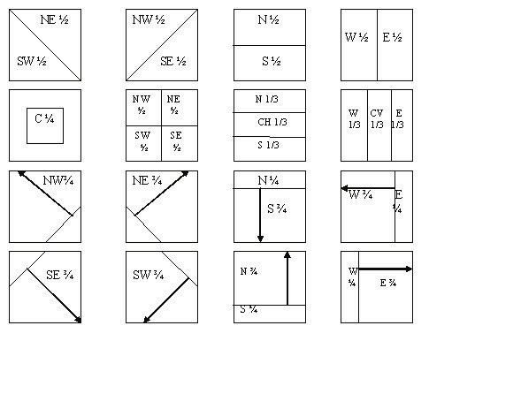
The Western Association of Map Libraries is an independent association of persons. The Membership has defined its
Principal Region for meeting locations as: the Provinces of Alberta and British Columbia, and the States of Alaska, Ari-
zona, California, Colorado, Hawaii, Idaho, Montana, Nevada, New Mexico, Oregon, Utah, Washington and Wyoming.

Membership in WAML is open to any individual interested in furthering the purpose of the Association, which is “to
encourage high standards in every phase of the organization and administration of map libraries.” Membership includes
receipt of all issues of the Information Bulletin and Electronic News & Notes (if an email address is provided), mail an-
nouncements of WAML meetings, voting privileges and receipt of WAML ballots.

Dues are US$30 per year and all memberships begin July 1. You may join any time of the year by sending your name,
address, phone, fax, email address and US$30 to the WAML Treasurer at the address below. Make checks payable to
“WAML” or the “Western Association of Map Libraries.” Lifetime membership is open to any individual for a one-time
payment of US$500. In addition to all membership privileges listed above, Lifetime Members also receive a copy of
each volume published in the WAML Occasional Paper series. For more information about WAML, its purpose, meetings
and membership, see the WAML Web site at http://www.waml.org or contact an officer listed below.

WAML and its Information Bulletin operate on a membership/volume-year basis. Subscriptions begin July 1 and end on
June 30 the following year. Mid-year joiners/subscribers will receive back issues for that year. Back issues of the Infor-
mation Bulletin are available for US$10/volume, or portion thereof, from the Subscription Manager.

Subscriptions to the Information Bulletin are US$35 per volume year. The Information Bulletin is issued three times
each year: Issue #1 in November, Issue #2 in March, and Issue #3 in July. In addition to the subscription cost, US$3 is
charged for postage to Canada and US$10 is charged for mailing to countries outside of the US and Canada.

                WAML Executive Board (July 1, 2004 - June 30, 2005)
President                               Past President                            Secretary
Julie Sweetkind-Singer                  Sue Haffner                               Ken Rockwell
GIS & Map Librarian & Bibliogra-        CSU-Fresno Library                        Map & Science Cataloger
pher                                    5200 N. Barton Ave., MS ML34              J. Willard Marriott Library
Branner Library/Map Collection          Fresno, CA 93740-8014                     University of Utah
Stanford, CA 94305-2210                 (559) 278-2405                            295 S 1500
(650) 725-1103                          Fax: (559) 278-6952                       E, Salt Lake City, UT 84112-0860
Fax: (650) 725-2534                     sue_haffner@csufresno.edu                 (801) 581-8324
sweetkind@stanford.edu                                                            ken.rockwell@library.utah.edu
                                        Treasurer
Vice President/President Elect          Cynthia Jahns                             Business Manager
Mabel Suzuki                            Head, Maps Unit                           Julie Hoff
University of Hawaii at Manoa           Science & Engineering Library             WAML Book & Sales Manager
Thomas H. Hamilton Library              University of California-Santa Cruz       Map Collection
2550 The Mall                           1156 High St.                             Arizona State Library
Honolulu, Hawaii 96822                  Santa Cruz, CA 95064-1078                 1700 West Washington
(808) 956-8230                          (831) 459-3187                            Phoenix, AZ 85007
FAX (808) 956-5968                      Fax: (831) 459-4187                       (602) 542-4343
mabel@hawaii.edu                        cjahns@cats.ucsc.edu                      Fax: (602) 542-4400
                                                                                  jhoff@lib.az.us
                                        Subscription Manager
                                        Jim O’Donnell
                                        Geology Library 100-23
                                        California Institute of Technology
                                        Pasadena, CA 91125
                                        wamlsubsmgr@yahoo.com
Western Association of Map Libraries

  Volume 36, No. 2                    INFORMATION BULLETIN                                                                     March 2005

                                                         Table of Contents

WAML Business
  Announcements ........................................................................................................................100

Photo Essay: Halloween Flood at University of Hawai’i Library.................................................101
 Mabel Suzuki, Government Documents Librarian, Ross Togashi, Map Collection Technician
 Photo credits: Ross Togashi, Susan Tokairin, Lloyd Tsukano

Index to Geologic Maps of Utah by U.S.G.S. Topographic
  Quadrangle Name, Part3: 1971-1980, M - Z compiled by Richard Soares.........................................111

Reviews of Atlases, Books and Digital Resources edited by Kathy Rankin ..........................................135
       “Response to Arizona Electronic Atlas Review” by the Arizona Electronic Atlas Team; Historical Atlas of
       the Napoleonic Era reviewed by Karen L. Dennison; Epic Wanderer: David Thompson & the Mapping
       of the Canadian West reviewed by Bruce Sarjeant; The World Through Maps: a History of Cartography
       reviewed by Tim Ross; Historical Atlas of the Arctic reviewed by Janet Collins; The Palgrave Concise
       Historical Atlas of the Cold War reviewed by Greg Armento; Historical Atlas of the Pacific Northwest
       reviewed by Matthew Parsons; The Political Mapping of Cyberspace reviewed by Christine Kollen

New Mapping of Western North America compiled by Ken Rockwell...................................143

News of Note compiled by Linda Zellmer
  Benchmarks ..................................................................................................................................148
  Canadian News..............................................................................................................................149
  Cataloging News ...........................................................................................................................150
  Conferences & Classes...................................................................................................................151
  Digital Spatial Data ........................................................................................................................152
  Employment.................................................................................................................................154
  Federal, State and Local Government.................................................................................................157
  General News...............................................................................................................165
  Internet Resources.................................................................................................................166
  New Publications..........................................................................................................................167
  Periodical Articles.............................................................................................................169

        US ISSN 0049-7282 © 2005 by The Western Association of Map Libraries LC #72-625238
WAML Information Bulletin 36(2) March 2005
Instructions for Authors
The Western Association of Map Libraries Information Bulletin publishes feature articles, photoessays, asso-
ciation business and selected news and notes related to all forms of cartographic information, including maps,
spatial data, GIS, and all aspects of map librarianship. Articles are invited that will address the interests of the
publications’ audience. Individuals are encouraged to submit unsolicited articles for consideration.
Length: Articles should be submitted to the Information Bulletin editor via email or on disk in either Micro-
soft Word or ASCII text format. Submissions should be accompanied by a printed copy which is no more than
20 double-spaced printed pages. Do not include any special formatting, such as page breaks and indentations
in the article. Paragraphs should be separated by two line breaks. When submitting articles on disk, please note
the author(s) name(s), the word processing program, a brief title of your article and the file name(s) on the disk.
Cartographic information is, for the most part, a visual medium, so illustrations should be included whenever
possible. Note the approximate location of illustrations by inserting a separate sentence in the text of the article:
Insert Figure 1 Here
The Production Editor will place the image based on the text flow and page layout of the article.
Illustrations: Illustrations and graphic material should be submitted in scanner-ready or computer-readable
form (gif, jpg or tiff). If it is absolutely impossible to submit scanned images, photographic prints and photocop-
ies may be submitted. All photocopies, even copies of black and white illustrations, should be copied on a color
copy machine, as they have a higher resolution than standard black and white copiers. Tables should be word
processed and saved as a separate file on the disk.
References: References should be included in the text in Author Date format (Jones, 1998). References Cited
should be listed at the end of the article in a separate section titled REFERENCES CITED. Citations should be
listed alphabetically and written in Author Date style. References to web sites should be written:
Author’s Last Name, First Name, Month, Day & Year Updated. Title of the web site. (Date site ac-
cessed).
Author Information: The author should include a brief title before the text of the article. Information about the
author(s) should also be included: author’s name, position, address and e-mail address, if available.
Editing: The editors reserve the right to make minor copy-editing changes.
Acceptance of manuscripts: The WAML Information Bulletin editors reserve the right to accept or reject
articles.
Book, Atlas & Media Reviews
Atlas and book reviews and reviews of digital cartographic products, software and data are welcome. Contact
the Atlas & Book Review Editor, Kathy Rankin or the IB Editor. For more information on atlas and book re-
views, see the instructions for reviewers in the Book Review section of the Information Bulletin.
97WAML Information Bulletin 36(2) March 2005
Contribution Guidelines for Electronic News and Notes
Electronic News and Notes contains information on: Benchmarks (major events related to people or Map
Libraries, specifically map library events in or about the principal region), Canadian News, Cataloging News,
Conferences and Classes, Digital Spatial Data, Employment, General News, Internet Resources, New Publica-
tions and cartographic materials, Periodical Articles and news from US Federal, State and Local Government
agencies related to map librarianship and the principal region. Submit items to the News and Notes Editor or the
appropriate State or Province editor at any time for inclusion in WAML Electronic News and Notes (E-N & N).
E-N & N is a monthly publication that is compiled and posted on the WAML web site at http://www.waml.org.
The E-N & N Editor appreciates receiving contributions via e-mail, but will accept regular mail as well. Please
flag time-sensitive items in the subject line. Back issues of E-N & N can be viewed on the WAML Web site.
Selected E-N & N items also appear in the Information Bulletin. Potential sources for news items include:
communication with colleagues, listservs (please acknowledge original author and list), Web sites (use search
engines to search for maps, atlases, cartography, geospatial data, GIS and your state, county or city), automated
notification services, journals and newspapers, vendor publisher and agency catalogs, newsletters and confer-
ence announcements.
E-N & N includes the regular feature “New Mapping of Western North America.” Submit citations for new
print and digital maps and atlases of the Western United States and Canadian Provinces to Ken Rockwell, New
Mapping Editor. Include ordering information if possible.
Information Bulletin and Electronic News & Notes
EDITORIAL STAFF
Electronic News & Notes Editor New Mapping of Western North Photo Essay Editor
Linda Zellmer America Editor Ross Togashi
Head, Geology Library Ken Rockwell Map Collection
Indiana University Libraries Marriott Library University of Hawaii Libraries
1001 East Tenth Street, Room 601 University of Utah 2550 The Mall
Bloomington, Indiana 47405-1405 Salt Lake City, UT 84112 Honolulu, HI 96822
(812) 855-7170 ken.rockwell@library.utah.edu (808) 956-6199
Fax (812) 855-6614 Fax (808) 956-5968
lzellmer@indiana.edu Information Bulletin Editor rtogashi@hawaii.edu
Matthew Parsons
Atlas & Book Review Editor Map Collection and Cartographic Editorial Advisor and
Katherine L. Rankin Information Services Unit Micrographics/Technology Editor
Bibliographic & Metadata Services Larry Cruse
Univ. of Washington Libraries
University Libraries University Library, C075P
University of Nevada, Las Vegas Box 352900
UC San Diego
4505 Maryland Parkway Seattle, WA 98195
La Jolla, CA 92093-0175
Box 457034 Phone: (206) 543-9392 (619) 534-1248
Las Vegas, NV 89154-7034 parsonsm@u.washington.edu Fax (619) 534-7548
(702) 895-2224 Larry_Cruse@UCSDLIBRARY.
Fax (702) 895-2280 ucsd.edu
krankin@ccmail.nevada.edu
98WAML Information Bulletin 36(2) March 2005
State and Province Editors
State and Province Editors have volunteered to be especially vigilant for news, notes and ideas for features
and will accept contributions for their state or province at any time and forward them for publication.
Alaska Editor Colorado Editor Utah Editor
John Kawula Christopher Thiry Peter L. Kraus
Government Documents & Map Map Librarian University of Utah
Librarian Arthur Lakes Library J. Willard Marriott Library
Rasmuson Library Colorado School of Mines Government Documents
University of Alaska Golden, CO 80401-1887 295 S 1500 E
Fairbanks, AK 99775-6800 (303) 273-3697 Salt Lake City, UT 84112
ffjdk@uaf.edu Fax (303) 273-3199 801-581-8394 (work)
cthiry@mines.edu 801-585-3464 (fax)
Arizona Editor
Dale Steele Hawaii/Pacific Rim Editor Washington State Editor
Arizona Dept of Transportation Riley Moffat Matthew Parsons
Division of Learning Resources Map Librarian
British Columbia Editor Brigham Young University Univ. of Washington Libraries
Tim Ross Box 1966
Map Collection and Cartographic
Map Librarian Laie, HI 96762
University of British Columbia (808) 293-3850 Information Services Unit
Library Fax (808) 293-3877 Box 352900
1956 Main Mall moffatr@byuh.edu Seattle WA 98195
Vancouver, BC V6T 1Z1 (206) 543-9392
(604) 822-6191 Nevada Editor parsonsm@u.washington.edu
Voice Mail (604) 822-2231 Linda Newman
Fax (604) 822-3335 DeLaMare Library/MS 262 Editor vacancies:
timross@unixg.ubc.ca University of Nevada Alberta, Idaho, Montana, New
Reno, NV 89557 Mexico, Oregon, Wyoming
California Editor (775) 784-6945 ext. 20
Phil Hoehn Fax (775) 784-6949
Librarian lnewman@unr.edu
David Rumsey Collection
51 Levant St.
San Francisco, CA 94114-1409
(415) 431-1423
philhoehn@juno.com
99WAML Information Bulletin 36(2) March 2005
Lists for 2003/04 Membership Year
Committees and Representatives
Executive Board Membership/Hospitality Com- PAC Microforms Subcommittee
President -- Julie Sweetking-Singer mittee: Larry Cruse (1993- )
Vice President/President Elect -- Carol Doyle (2002- ) Representatives/Liaisons
Mabel Suzuki Yvonne Wilson (2002- ) To AACCCM -- Mary Larsgaard
Secretary -- Ken Rockwell Nominating Committee (1992- )
Treasurer -- Cynthia Jahns Christopher J.J. Thiry (2002 - ) To ACMLA -- Tim Ross (1991- )
Past President -- Sue Haffner Need additional members To ALA/MAGERT –
Appointees Publications Advisory Committee Kathy Rankin (2003-)
Archivist -- (PAC): To CCISA – Linda Zellmer (1999- )
Julie Sweetkind, (2000- ) Linda Newman (2003- ) To CUAC --
Business Manager -- David Deckelbaum (1999- ) David Deckelbaum (2003 - )
Julie Hoff (2002- ) Ex Officio: Need additional representive
Subscription Manager -- Linda Zellmer (2000 - ) To GSIS -- Linda Newman (2002- )
Jim O’Donnell, (1997- ) Julie Hoff (2002 - ) To IFLA --
Web Manager -- Dorothy McGarry (2002- )
Linda Zellmer (1999- ) To SLA/G&M -- Linda Zellmer
(2002- )
Announcements:
Western Association of
Map Libraries, Spring
2005 Meeting
Where: Univ. of Colorado at
Boulder
When: March 23-26, 2005
Host: Katie Lage
Zippered tote bags are still available from MAGERT. To re-
URL: ceive your tote bag, please send a check for $23.00, payable
http://ucblibraries.colorado. to ALA-MAGERT, to:
edu/map/waml/waml.htm. Steve Rogers, Map Room, 211 Main Library, Ohio State
University, 1858 Neil Ave Mall, Columbus, OH 43210
100WAML Information Bulletin 36(2) March 2005
HALLOWEEN FLOOD AT UNIVERSITY OF HAWAI`I LIBRARY
Mabel Suzuki, Government Documents Librarian
Ross Togashi, Map Collection Technician
Photo credits: Ross Togashi, Susan Tokairin, Lloyd Tsukano
On Halloween’s eve, October 30, just a handful of people were in first priority, followed by Asia,
2004, a flash flood swept through the building, including a class of older Pacific area nautical charts,
Manoa Valley in Honolulu, cut- distance education students who world map series such as IMW
ting a swath through a section were attending an all-day session. and Karta Mira, and lastly AMS
of the main campus of the Uni- These students had to break the topographic series of other areas
versity of Hawai`i and heaved windows with a chair to escape including Latin America, Europe,
massive destruction on a number the floodwaters in just the nick of Middle East and Africa. The lim-
of buildings, including Hamil- time. ited freezer container space made
ton Library. The ground floor of it impossible to rescue all drawers.
Hamilton housed the Government In the days that followed, library Maps of more easily obtainable
Documents and Maps Department, staff and hundreds of volunteers areas such as the US states had to
which includes the regional fed- sloshed through the muck to be abandoned. It is estimated that
eral documents depository, a large retrieve as much as they could. approximately one-third of the
United Nations collection, and the The maps and aerial photos were map collection was retrieved. It
map collection. Approximately among the first to be rescued. In was less successful with govern-
800,000 documents in paper, 1.6 priority order, the aerial photo- ment documents. Only a small
million microforms, several thou- graphs of the Trust Territory of the percentage of items were undam-
sand CD-ROMs and DVD prod- Pacific Islands (TTPI) archives, aged by water. These were pulled
ucts, 165,000 maps and 92,000 followed by aerial photos of the off the shelves, placed in boxes
aerial photographs were damaged western Pacific (WWII vintage) and rushed into the freezers.
or destroyed by the flood. All which were deemed difficult to
furniture and equipment, including obtain were transported to the The task of cleaning and restor-
desks, chairs, tables, study carrels, Library’s Preservation unit where ing the maps, aerial photos, and
computers and printers, map cases, stations were set up to wash and documents are now with the
file cabinets, scanner, large format dry these photos. Other large Preservation Department. Paper
copier, light table, zoom transfer photos were washed and hung to conservators and other conserva-
scope, and assorted office furni- dry outdoors (between trees, on tion specialists from the United
ture, supplies, and personal effects the lanais and classrooms of the States and New Zealand were
were completely destroyed, having neighboring building). While a brought in to work with and train
been tossed about by the speed few thousand were cleaned, the the Preservation staff. They
and strength of the flood and the time element of avoiding mold inspected the extent of damage
height it reached, well over 6 to 7 growth made it impossible to wash and experimented with various
feet in the map room. the entire 90,000 collection. The paper types to determine the best
rest of the photos were placed in cleaning methods and procedures.
Other departments housed on the Matson Company refrigerated About half of the maps will be
ground floor of Hamilton were shipping containers, with the tem- cleaned in-house. The balance,
similarly affected. These included perature set at just below freezing. approximately 17,000 maps have
Acquisitions, Serials, Cataloging, Matson freezer containers were been shipped to a Texas-based res-
the server room of the Library’s also used to house the maps and toration company, Belfor, which
Systems office, and the Library documents. has been contracted to clean the
and Information Science Program. maps and freeze dry the books.
It was fortunate that the flood oc- Map drawers were pulled in order From early reports, the results
curred on a Saturday night when with rare, Hawai`i, and Pacific as of the work at Belfor have been
101 University of Hawaii FloodWAML Information Bulletin 36(2) March 2005
very encouraging and many of the clean-up operations. The Univer- countries and purchasing selected
maps are being restored to useable sity is now in the planning stages replacements. While the flood had
condition. on how to proceed with which inflicted considerable damage, it
collections and staff would be also provides a great opportunity
The ground floor of Hamilton returning and in what configura- in building a digital geographic
Library is now completely cleaned tion. Government Documents data repository for Hawai`i, and
and cleared of all debris. BMS and Maps is in a rebuilding phase, participation in national digitiza-
Catastrophe, a Texas-based disas- acquiring donations of documents tion efforts.
ter recovery company, contracted and maps from all over the main-
with the University to conduct land, Hawai`i, and from foreign
Damage to the Map Collection and the rest of the basement was extensive. (photo: L. Tsukano)
Muddy water filled the Map Collection to a height of 6-7’ as shown by high water marks on far
wall. Particle board wall (left) shows damage from water flow. (photo: L. Tsukano)
University of Hawaii Flood 102WAML Information Bulletin 36(2) March 2005
Vertical planfiles holding USGS 7.5min. quads (left) tipped
over from water flow. (photo: L. Tsukano)
A volunteer retrieves our scanner. (photo: L. Tsukano)
103 University of Hawaii FloodWAML Information Bulletin 36(2) March 2005
Map drawers were retrieved and taken outside by Library staff, students, faculty and
volunteers. (photo: L. Tsukano)
Every map drawer was filled with mud, debris and water. (photo: L. Tsukano)
University of Hawaii Flood 104WAML Information Bulletin 36(2) March 2005
Initially, aerial photographs and some maps were rinsed of mud and hung to dry. (photo:
S. Tokairin)
NASA U2 aerial photographic transparencies held in con-
tainers were washed. (photo: L. Tsukano)
105 University of Hawaii FloodWAML Information Bulletin 36(2) March 2005
Aerial photograph prints were hung to dry in every available space inside the Library, in a
neighboring building, and outdoors. (photo: L. Tsukano)
Larger aerial photograph enlargements and maps on mylar were dried outdoors. (photo:
S. Tokairin)
University of Hawaii Flood 106WAML Information Bulletin 36(2) March 2005
Matson Company refrigerated shipping containers were used to freeze
and hold the maps, photographs, and documents. (photo: L. Tsukano)
The Hawaii State Convention Center’s loading dock was utilized in shuffling and reloading the freezer con-
tainers. Approximately 180 map drawers were shipped to Belfor in Fort Worth, Texas. (photo: R. Togashi)
107 University of Hawaii FloodWAML Information Bulletin 36(2) March 2005
University employees carefully stacked the map drawers on pallets, and
secured them with pieces of lumber. (photo: R. Togashi)
An additional 140 map drawers and 150 boxes of aerial photographs were moved to an
off-campus commercial freezer/storage site. (photo: R. Togashi)
University of Hawaii Flood 108WAML Information Bulletin 36(2) March 2005
Restoration work starts in the Library’s Preservation Department. (photo: R. Togashi)
Frozen photographs are carefully thawed before restoration work can begin. (photo: R.
Togashi)
109 University of Hawaii FloodWAML Information Bulletin 36(2) March 2005
BMS Catastrophe crew stripped and disinfected the entire basement
floor. (photo: L. Tsukano)
View of the basement looking towards the site of the former Map Collection and Library
School. (photo: R. Togashi)
University of Hawaii Flood 110WAML Information Bulletin 36(2) March 2005
Index to Geologic Maps of Utah by U.S.G.S. Topographic Quadrangle Name
Part 3: 1971-1980, M-Z
(Continuation of A-L previously published in WAML Information Bulletin 36(1):17-40)
Complied by Richard E. Soares
Natural Science Librarian
California State University, Chico
INTRODUCTION indicating subject matter if other Information System (GNIS) at:
than geology, and reference to the http://geonames.usgs.gov
This index identifies publications publication or source in abbreviated
of the U.S. Geological Survey form. Entries for the obsolete and Once the quadrangle name for an
(U.S.G.S.) and the Utah Geological 15 minute quadrangles have “see” area of interest is identified, it is
Survey (U.G.S.) published be- references to the current 7.5 minute then easily found in alphabetical
tween 1971 and 1980 appearing in quadrangles. order within this index. Multiple
selected series (see list in Legend) entries may exist for a quadrangle
that contain detailed geologic maps To use this index, one must name, each giving data to a differ-
of Utah. The index correlates these first determine the name of the ent map and source.
publications to the U.S.G.S. 7.5 quadrangle(s) that cover an area
minute quadrangles of Utah. of interest. This is easily done by Earlier indexes, part 1, 1883-1961²,
using a Utah topographic map index and part 2, 1962-1970³, are consol-
Most of the maps indexed are published and distributed by the idated and available free online at
separates folded into a pocket to U.S.G.S. Most library map collec- http://www.csuchico.edu/~rsoares/
accompany a geologic report while tions will have multiple copies of Utah_Geologic_Mapping/
a few select maps are found on such indexes. Pages of one such UtahQuadrangleMapRefGuide.
pages within reports. All of the index, Utah index to topographic htm.
maps are at a scale of 2 miles to and other map coverage, can be
the inch, approximately 1:125,000 viewed at: http://www.csuchico.
or larger. edu/~rsoares/Utah_Geologic_Map- ¹ Utah Index to topographic and
ping/UtahQuadrangleMapRef- other map coverage. 1983. Reston,
The index is arranged alphabeti- Guide.htm Va., U.S. Geological Survey. p.39
cally by quadrangle name. Not all ²Soares, Richard E., 1991. Index
current 7.5 minute quadrangles are You can obtain your own copy of a to Geologic Maps of Utah by
listed, only those covered by map- Utah topographic map index from: U.S.G.S. Topographic Quadrangle
ping. Also included are obsolete Name Part 1: 1883-1961. Informa-
7.5 minute quadrangle names as U.S. Geological Survey Map Dis- tion Bulletin (WAML) vol. 22,
found on maps indexed and 15 tribution no.3, p.163
minute quadrangle names as found U.S.G.S. Map Sales (USDI) ³ Soares, Richard E., 1992. Index
in the Utah index to topographic Federal Center, Building 810 US- to Geologic Maps of Utah by
and other map coverage.¹ DOI U.S.G.S. Topographic Quadrangle
PO Box 25286 Name Part 2: 1962-1970. Informa-
Each entry for a current 7.5 minute Denver, CO 80225 tion Bulletin (WAML) vol. 24,
quadrangle name includes data for Or phone: (303) 236-7477 or (888) no.1, p.13
a map that covers part or all of the 275-8747 or Fax (303) 202-4693
quadrangle. Data includes scale as
an abbreviated representative frac- A quadrangle name can also be
tion, extent of quadrangle cover- determined through the internet us-
age in abbreviated form, notation ing the U.S.G.S. Geographic Names
111 Index to Geologic Maps of UtahWAML Information Bulletin 36(2) March 2005
LEGEND
The following is a legend to the abbreviations used throughout this index, and diagrams depicting
the coverage notation.
U.S.G.S. Series U.G.S. Series
B Bulletin Ub Bulletin
C Circular Uc Circular
CI Coal Investigations Map Ums Map Series
GP Geophysical Insvestigations Map Umi Miscellaneous Publications
GQ Geologic Quadrangle Map Um Monographs
I Miscellaneous Geologic Investigations Map Uog Oil and gas field studies
MF Miscellaneous Field Studies Map Uo Open File Reports
OC Oil and Gas Investigations Chart Ur Reports of Investigation
OM Oil and Gas Investigations Map Us Speical Studies
P Professional Paper Uw Water Resource Bulletin
W Water-Supply Paper
Coverage abbreviations & others
C Center
CH Center-horizontal
CV Center-vertical Coverage Diagrams
E East
Mtn. Mountain
N North
NE Northeast
NW Northwest
Res. Reservoir
S South
SE Southeast
SW Southwest
W West
Index to Geologic Maps of Utah 112WAML Information Bulletin 36(2) March 2005
Supplement to Part 3: 1971-1980, A-L in WAML Information Bulletin 36(1):17-40.
Quad Name Scale Coverage Source
1:
Antelope Range 24k complete MF 1140
Cockscomb Ridge 24k complete I 827
Elsinore 24k complete MF 1107
Joseph Peak 24k complete [volcanic rocks] MF 1108
Quad Name Scale Coverage Source
1:
Magna 100k complete Ums 54A
Magna 24k complete GQ 923
Magua 100k complete MF 1198
Mahogany Point 42k complete Um 3 fig.46 p.205
Mahogany Point 63k complete Ub 112 pl.1
Mahogany Point 63k complete Ub 112 pl.3
Mahogany Point 63k complete Uo 17 fig.6
Mahogany Point 63k complete Uo 17 fig.5
Malmsten Peak 125k complete Ub 102 pl.1
Malmsten Peak 125k complete Ums 34
Malmsten Peak 24k complete MF 1115
Manti 125k complete W 1896 pl.1
Mantua 100k complete Ums 53A
Mantua 100k complete MF 1198
Mantua 125k NW ¾ Ub 115 pl.1
Mantua 125k NW ¾ Ums 57
Mantua 24k complete MF 720
Marysvale 125k complete Ub 102 pl.1
Marysvale 125k complete Ums 34
Marysvale 24k NW ¼ [geology and uranium] I 1177
Marysvale 24k complete MF 1106
Marysvale 15’ see: Malmsten Peak, Marysvale,
Marysvale Peak, Piute Reservoir
Marysvale NW see: Marysvale
Marysvale Peak 125k complete Ub 102 pl.1
Marysvale Peak 125k complete Ums 34
Marysvale SE see: Malmsten Peak
113 Index to Geologic Maps of UtahWAML Information Bulletin 36(2) March 2005
Marysvale SW see: Piute Reservoir
Matlin 125k complete Ub 115 pl.2
Matlin 125k complete Ums 57
Matts Summit 42k S 1/3 Um 3 fig.27 p.355
Mayfield 125k N¾ W 1896 pl.1
Mazuki Point 125k complete [coal] I 1033C
Mazuki Point 125k complete [overburden] I 1033D
Mazuki Point 125k complete I 1033G
Mazuki Point 125k complete [landslide] I 1033H
Mazuki Point 24k complete CI 64 sh.1
McIntyre 24k E¼ I 883
Meadow Spring 125k complete Ub 115 pl.2
Meadow Spring 125k complete Ums 57
Meadowville 42k NE ¼ Ub 96 pl.2
Mesa Butte 42k complete Um 3 fig.31 p.491
Messix Peak 125k complete Ub 115 pl.1
Messix Peak 125k complete Ums 57
Mexican Mountain 24k E½ Ub 113 pl.1
Mexican Mountain 24k E½ Uo 20 pl.1
Middle Mountain 48k complete MF 635
Midvale 100k complete Ums 54A
Midvale 100k complete MF 1198
Midvale 15’ see: Draper, Midvale, Salt Lake City
South, Sugar House
Milford 15’ see: Milford Flat
Milford Flat 24k NW ¼ Us 46 pl.1&2
Miller Cove 48k complete MF 636
Mills Junction 100k complete Ums 54A
Mills Junction 100k complete MF 1198
Mills Junction 24k complete GQ 924
Mills Junction 50k complete Us 51 pl.IIIa
Miners Basin 125k complete Ub 115 pl.2
Miners Basin 125k complete Ums 57
Minnie Maud Creek 42k S 1/3 Um 3 fig.38 p.391
West
Minnie Maud West see: Minnie Maud Creek West
Monroe 15’ see: Antelope Range, Elsinore, Mon-
roe Peak
Monroe NW see: Elsinore
Monroe Peak 125k complete Ub 102 pl.1
Index to Geologic Maps of Utah 114WAML Information Bulletin 36(2) March 2005
Monroe Peak 125k complete Ums 34
Monroe SW see: Antelope Range
Monument Peak 125k complete Ub 115 pl.1
Monument Peak 125k complete Ums 57
Monument Peak NE 125k complete Ub 115 pl.1
Monument Peak NE 125k complete Ums 57
Monument Peak NW 125k complete Ub 115 pl.1
Monument Peak NW 125k complete Ums 57
Monument Peak SW 125k complete Ub 115 pl.1
Monument Peak SW 125k complete Ums 57
Monument Point 125k complete Ub 115 pl.1
Monument Point 125k complete Ums 57
Moody Creek 15’ see: Horse Pasture Mesa, Moody
Creek SW, Scorpion Gulch, Silver
Falls Bench
Moody Creek SW 125k complete [coal] I 1033C
Moody Creek SW 125k complete [overburden] I 1033D
Moody Creek SW 125k complete I 1033G
Moody Creek SW 125k complete [landslide] I 1033H
Moon Bottom 125k complete [structure contours] I 1156
Moonwater Point 125k NE ½ [structure contours] I 1156
Moonwater Point 15’ see: Chicken Fork, Moonwater Point
Morgan 24k complete MF 318
Morgan 15’ see: Bybee Knoll, Morgan
Moroni 125k complete W 1896 pl.1
Moroni 15’ see: Big Hollow, Fountain Green
North, Fountain Green South, Mo-
roni
Mounds 24k complete I 1202
Mount Aire 12k S 1/3 Ur 147
Mount Aire 24k S½ Ub 114 pl.1
Mount Aire 24k S½ Ums 49
Mount Bartles 42k complete Um 3 fig.32 p.371
Mount Belknap 125k complete Ub 102 pl.1
Mount Belknap 125k complete Ums 34
Mount Belknap 24k SE ¼ I 1230
Mount Belknap 24k complete MF 967
Mount Brigham 125k complete Ub 102 pl.1
Mount Brigham 125k complete Ums 34
Mount Brigham 24k S 2/3 I 1230
115 Index to Geologic Maps of UtahWAML Information Bulletin 36(2) March 2005
Mount Brigham 24k complete MF 1105
Mount Brigham 3k S¼ Ub 102 pl.12
Mount Dutton 125k NE ¼ Ums 34
Mount Dutton 125k NE ¼ Ub 102 pl.1
Mount Ellen 42k complete Um 2 fig.25 p.155
Mount Ellen 4 see: Factory Butte
Mount Ellen 5 see: Town Point
Mount Ellen 6 see: Steamboat Point
Mount Ellen 15’ see: Dry Lakes Peak, Mount Ellen,
Steele Butte, Stevens Mesa
Mount Ellen NE see: Dry Lakes Peak
Mount Ellen NW see: Stevens Mesa
Mount Ellen SW see: Steele Butte
Mount Hillers 15’ see: Cass Creek Peak
Mount Peale 1 SW see: La Sal East
Mount Peale 2 SE see: La Sal West
Mount Peale 3 NE see: Sandstone Draw
Mount Peale 4 NW see: Lisbon Valley
Mount Peale 6 see: La Sal West
Mount Peale 7 see: La Sal East
Mount Peale 10 see: Lisbon Valley
Mount Peale 11 see: Sandstone Draw
Mount Pennell 42k complete Um 2 fig.31 p.169
Mount Pennell 63k W ½ [coal] MF 1082A
Mount Pennell 2 see: Cass Creek Peak
Mount Pennell 3 see: Mount Pennell
Mount Pennell 4 see: Cave Flat
Mount Pennell 5 see: The Post
Mount Pennell 6 see: Ant Knoll
Mount Pennell 7 see: Copper Creek Benches
Mount Pennell 15’ see: Ant Knoll, The Post, Mount
Pennell, Cave Flat
Mount Pennell NE see: Mount Pennell
Mount Pennell NW see: Cave Flat
Mount Pisgah 100k complete Ums 53A
Mount Pisgah 100k complete MF 1198
Mount Pisgah 125k SW ½ Ub 115 pl.1
Mount Pisgah 125k SW ½ Ums 57
Mount Pleasant 125k complete W 1896 pl.1
Mount Pleasant 42k E½ Um 3 fig.11 p.27
Index to Geologic Maps of Utah 116WAML Information Bulletin 36(2) March 2005
Mountain Home 42k W 1/3 Um 2 fig.13 p.309
Mouth of Bear River 100k complete Ums 53A
Mouth of Bear River 100k complete MF 1198
Mouth of Bear River 125k complete Ub 115 pl.1
Mouth of Bear River 125k complete Ums 57
Naples 42k complete Um 2 fig.31 p.73
Navajo Point 125k complete [coal] I 1033C
Navajo Point 125k complete [overburden] I 1033D
Navajo Point 125k complete I 1033G
Navajo Point 125k complete [landslide] I 1033H
Navajo Point 24k complete CI 63 sh.1
Needle Eye Point 125k complete [coal] I 1033C
Needle Eye Point 125k complete [overburden] I 1033D
Needle Eye Point 125k complete I 1033G
Needle Eye Point 125k complete [landslide] I 1033H
Needle Eye Point 42k complete Um 1 fig.43 p.187
New Harmony 15’ see: Pintura
Nile Spring 125k E 1/3 Ub 115 pl.2
Nile Spring 125k E 1/3 Ums 57
Ninemile Knoll 63k complete GQ 1493
Nipple Butte 125k complete [coal] I 1033C
Nipple Butte 125k complete [overburden] I 1033D
Nipple Butte 125k complete I 1033G
Nipple Butte 125k complete [landslide] I 1033H
Nipple Butte 42k complete Um 1 fig.47 p.201
Nipple Butte 15’ see: Glen Canyon City, Lone Rock,
Nipple Butte, Tibbet Bench
Nipple Butte NE see: Tibbet Bench
Nipple Butte NW see: Nipple Butte
Nipple Butte SE see: Lone Rock
Nipple Butte SW see: Glen Canyon City
North Knoll Spring 125k complete P 971 pl.1
North Ogden 100k complete Ums 53A
North Ogden 100k complete MF 1198
North Ogden 125k NW ¼ Ub 115 pl.1
North Ogden 125k NW ¼ Ums 57
North Ogden 24k complete MF 428
Notch Peak 48k complete MF 636
Notch Peak 15’ see: Hell ‘n Maria Canyon, Miller
Cove, Notch Peak, Skull Rock Pass
117 Index to Geologic Maps of UtahWAML Information Bulletin 36(2) March 2005
Notom 42k complete Um 2 fig.35 p.177
Notom 63k E ¼ [coal] MF 1082A
Notom 1 see: Caine springs
Notom 3 SE see: Lower Bowns Reservoir
Notom 3 SW see: Deer Creek Lake
Notom 8 see: Caineville
Notom 9 see: Notom
Notom 13 see: Deer Creek Lake
Notom 14 see: Lower Bowns Reservoir
Notom 15’ see: Notom, Sandy Creek Benches
Notom 16 see: Sandy Creek Benches
Notom NE see: Notom
Notom SE see: Sandy Creek Benches
Nutters Hole 125k complete [structure contours] I 1156
Nutters Hole 15’ see: Crow Knoll, Duches Hole,
Moon Bottom, Nutters Hole
Ogden 100k complete Ums 53A
Ogden 100k complete MF 1198
Ogden 24k S¼ MF 428
Ogden Bay 100k complete Ums 53A
Ogden Bay 100k complete MF 1198
Old Woman Plateau 42k complete Um 3 fig.27 p.149
Old Woman Plateau 42k S 1/3 Ub 112 pl.2
Old Woman Plateau 42k S 1/3 Uo 17 fig.7&12
Onaqui Mountains 48k complete MF 921
South
Ophir 50k complete Us 51 pl.IIIb
Orderville 42k complete Um 1 fig.24 p.325
Orderville 15’ see: Glendale, Long Valley Junction,
Orderville
Orderville Canyon NE see: Straight Canyon
Orderville Canyon see: Cogswell Point, Slickrock
NW Bench
Orderville Canyon SE see: Clear Creek Mountain
Orderville Canyon SW see: Orderville
Orderville NE see: Long Valley Junction
Orderville SE see: Glendale
Orem 100k complete Ums 55A
Orem 100k complete [geol & mineral reserves] Ums 55D
Orem 105k NE ¼ [lithology] Ur 96 fig.2
Index to Geologic Maps of Utah 118WAML Information Bulletin 36(2) March 2005
Orem 15’ see: Aspen Grove, Bridal Veil Falls,
Orem, Timpanogos Cave
Ouray 125k complete [structure contours] I 1156
Ouray SE 125k complete [structure contours] I 1156
P R Spring 125k complete Uo 27 map I-VII
P R Spring 125k N 2/3 [structure contours] I 1156
Page Ranch 42k E¾ Um 1 fig.26 p.329
Page Ranch 42k NE ½ Uo 21 pl.1
Paradise 100k complete Ums 53A
Paradise 100k complete MF 1198
Paria 15’ see: Bridger Point, Fivemile Valley,
Lower Coyote Spring, West Clark
Bench
Paria NE see: Lower Coyote Spring
Paria NW see: Five Mile Valley
Paria SE See: Bridger Point
Paria SW see: West Clark Bench
Pariette Draw SW 125k SE 1/3 [structure contours] I 1156
Park City East 24k complete GQ 852
Park City West 12k NW ¼ Ur 147
Park City West 24k SW ¼ Ub 114 pl.1
Park City West 24k SW ¼ Ums 49
Park Valley 125k complete Ub 115 pl.2
Park Valley 125k complete Ums 57
Park Valley 31k complete I 873
Park Valley 15’ see: Park Valley, Rosette, Rosevere
Point, Standrod
Parker Knoll 125k complete Ub 102 pl.1
Parker Knoll 125k complete Ums 34
Partoun 63k NW ¾ Ur 117 fig.2
Partoun 63k complete Ub 99 pl.2
Patmos Head 24k W¼ P 688 fig.1
Patmos Head 42k complete Um 3 fig.34 p.377
Patmos Head 6k SW ¼ [eng. geology, mine workings, I 704
over burden etc.]
Patterson Pass 125k E 1/3 Ub 115 pl.2
Patterson Pass 125k E 1/3 Ums 57
Pelican Lake 125k S ¼ [structure contours] I 1156
Pelican Point 100k complete Ums 55A
Pelican Point 100k complete [geol & mineral reserves] Ums 55D
119 Index to Geologic Maps of UtahWAML Information Bulletin 36(2) March 2005
Peplin Flats 125k complete Ub 115 pl.2
Peplin Flats 125k complete Ums 57
Peterson 100k complete MF 1198
Petes Cove 125k complete [coal] I 1033C
Petes Cove 125k complete [overburden] I 1033D
Petes Cove 125k complete I 1033G
Petes Cove 125k complete [landslide] I 1033H
Petes Cove 42k complete Um 1 fig.53 p.215
Phonolite Hill 125k complete Ums 34
Phonolite Hill 125k complete Ub 102 pl.1
Picture Rock Hills 125k N¾ P 818C fig.2
Picture Rock Hills 15’ see: Picture Rock Hills, The Hog-
back
Pigeon Mountain 125k complete Ub 115 pl.2
Pigeon Mountain 125k complete Ums 57
Pilot Peak 125k E 1/3 Ub 115 pl.2
Pilot Peak 125k E 1/3 Ums 57
Pine Canyon 42k complete Um 3 fig.40 p.397
Pine Lake 125k complete [coal] I 1033C
Pine Lake 125k complete [overburden] I 1033D
Pine Lake 125k complete I 1033G
Pine Lake 125k complete [landslide] I 1033H
Pine Lake 24k complete CI 66
Pine Lake 42k SW ¾ Um 1 fig.55 p.221
Pine Spring Canyon 125k complete Uo 27 map I-VII
Pine Spring Canyon 125k complete [structure contours] I 1156
Pine Valley Hardpan 48k complete MF 637
North
Pine Valley Hardpan 48k complete MF 637
South
Pintura 24k E 2/3 Uog 13
Piute Reservoir 125k complete Ub 102 pl.1
Piute Reservoir 125k complete Ums 34
Piute Reservoir 24k complete MF 1116
Plain City 100k complete Ums 53A
Plain City 100k complete MF 1198
Plain City 125k N 1/3 Ub 115 pl.1
Plain City 125k N 1/3 Ums 57
Plain City SW 100k complete Ums 53A
Plain City SW 100k complete MF 1198
Index to Geologic Maps of Utah 120WAML Information Bulletin 36(2) March 2005
Plain City SW 125k N 1/3 Ub 115 pl.1
Plain City SW 125k N 1/3 Ums 57
Plug Peak NE 100k complete Ums 54A
Plug Peak NE 100k complete MF 1198
Plug Peak SE 100k complete Ums 54A
Podunk Creek 42k S¼ Um 1 fig.25 p.63
Pokes Point 125k complete Ub 115 pl.1
Pokes Point 125k complete Ums 57
Pole Creek 125k complete Ub 115 pl.2
Pole Creek 125k complete Ums 57
Pole Mountain 125k complete Ub 102 pl.1
Pole Mountain 125k complete Ums 34
Pollywog Lake 125k NW ¼ Ums 34
Pollywog Lake 125k NW ¼ Ub 102 pl.1
Pollywog Lake 32k NW ¼ Ub 102 pl.9
Portage 125k complete Ub 115 pl.1
Portage 125k complete Ums 57
Post see: The Post
Posy Lake 125k complete [coal] I 1033C
Posy Lake 125k complete [overburden] I 1033D
Posy Lake 125k complete I 1033G
Posy Lake 125k complete [landslide] I 1033H
Posy Lake 66k complete Ums 31
Potters Creek 125k complete Ub 115 pl.2
Potters Creek 125k complete Ums 57
Preacher Canyon 125k complete Uo 27 map I-VII
Prohibition Spring 125k complete Ub 115 pl.2
Prohibition Spring 125k complete Ums 57
Promontory Point 125k N½ Ub 115 pl.1
Promontory Point 125k N½ Ums 57
Provo 100k complete Ums 55A
Provo 100k complete [geol & mineral reserves] Ums 55D
Provo 15’ see: Provo, Spanish Fork, Spanish
Fork Peak, Springville
Public Shooting 100k complete Ums 53A
Grounds
Public Shooting 100k complete MF 1198
Grounds
Public Shooting 125k complete Ub 115 pl.1
Grounds
121 Index to Geologic Maps of UtahWAML Information Bulletin 36(2) March 2005
Public Shooting 125k complete Ums 57
Grounds
Pyramid Knoll 48k complete MF 635
Rainbow 125k complete Uo 27 map I-VII
Rainbow 125k complete [structure contours] I 1156
Rainbow 24k complete MF 893
Rainbow Point 42k complete Um 1 fig.23 p.57
Rainbow Point SW see: Deer Spring Point
Range Creek 15’ see: Chandler Falls
Range Creek NE see: Chandler Falls
Rasmussen Hollow 42k complete Um 2 fig.33 p.79
Raspberry Knoll 42k N 1/3 Um 2 fig.11 p.303
Rat Hole Ridge 125k W½ Uo 27 map I
Rat Hole Ridge 125k complete [structure contours] I 1156
Rat Hole Ridge 42k W 2/3 Um 2 fig.26 p.259
Rattlesnake Pass 125k complete Ub 115 pl.1
Rattlesnake Pass 125k complete Ums 57
Rays Valley 63k complete I 931
Red Breaks 125k complete [coal] I 1033C
Red Breaks 125k complete [overburden] I 1033D
Red Breaks 125k complete I 1033G
Red Breaks 125k complete [landslide] I 1033H
Red Dome 125k complete Ub 115 pl.2
Red Dome 125k complete Ums 57
Red Hole 24k CH 1/3, W part Ur 102 fig.1
Red Point 42k complete Um 3 fig.44 p.197
Red Tops 48k complete MF 633
Red Wash 125k S ¾ [structure contours] I 1156
Red Wash NW 125k S ½ [structure contours] I 1156
Red Wash SE 125k complete [structure contours] I 1156
Red Wash SW 125k complete [structure contours] I 1156
Ridgedale Pass 125k complete Ub 115 pl.1
Ridgedale Pass 125k complete Ums 57
Rilda Canyon 42k complete Um 3 fig.42 p.191
Rilda Canyon 63k S½ Ub 112 pl.3
Rilda Canyon 63k S½ Uo 17 fig.6
Rilda Canyon 63k S½ Uo 17 fig.5
Riverside 125k complete Ub 115 pl.1
Riverside 125k complete Ums 57
Rock Creek see: Dry Mountain
Index to Geologic Maps of Utah 122WAML Information Bulletin 36(2) March 2005
Rocky Pass Peak 125k complete Ub 115 pl.2
Rocky Pass Peak 125k complete Ums 57
Roger Peak 125k complete [coal] I 1033C
Roger Peak 125k complete [overburden] I 1033D
Roger Peak 125k complete I 1033G
Roger Peak 125k complete [landslide] I 1033H
Roger Peak 66k complete Ums 31
Rosette 125k complete Ub 115 pl.2
Rosette 125k complete Ums 57
Rosette 31k complete I 873
Rosevere Point 125k complete Ub 115 pl.2
Rosevere Point 125k complete Ums 57
Rosevere Point 31k complete I 873
Round Mountain 125k complete Ub 115 pl.2
Round Mountain 125k complete Ums 57
Round Mountain NW 125k complete Ub 115 pl.2
Round Mountain NW 125k complete Ums 57
Round Mountain SW 125k complete Ub 115 pl.2
Round Mountain SW 125k complete Ums 57
Roy 100k complete Ums 53A
Roy 100k complete MF 1198
Rozel 125k complete Ub 115 pl.1
Rozel 125k complete Ums 57
Rozel Point 125k complete Ub 115 pl.1
Rozel Point 125k complete Ums 57
Rozel Point SW 125k complete Ub 115 pl.1
Rozel Point SW 125k complete Ums 57
Runswick Wash 125k complete Ub 115 pl.2
Runswick Wash 125k complete Ums 57
Russian Knoll 125k complete Ub 115 pl.2
Russian Knoll 125k complete Ums 57
Saint John 50k complete Us 51 pl.IIIb
Sally Mountain 125k complete Ub 115 pl.1
Sally Mountain 125k complete Ums 57
Salt Lake City North 100k complete Ums 54A
Salt Lake City North 100k complete MF 1198
Salt Lake City North 24k SE ¼ [faults] Ur 94 pl.1
Salt Lake City South 100k complete Ums 54A
Salt Lake City South 100k complete MF 1198
Salt Lake City South 24k complete I 1173
123 Index to Geologic Maps of UtahWAML Information Bulletin 36(2) March 2005
Salt Wells 125k complete Ub 115 pl.1
Salt Wells 125k complete Ums 57
Saltair 100k complete Ums 54A
Saltair 100k complete MF 1198
Saltair NE 100k complete Ums 54A
San Arroyo Ridge 125k complete Uo 27 map I-VII
San Arroyo Ridge 125k S ½ [structure contours] I 1156
San Arroyo Ridge 42k complete Um 2 fig.27 p.261
San Juan Hill 2k SW ¼ I 674
Sand Pass 24k complete MF 1151
Sand Pass NE 24k complete MF 1150
Sand Pass NW 24k complete MF 1149
Sand Pass SE 24k complete MF 1150
Sandstone Draw 108k N¼ P 988B fig.4
Sandy Creek Benches 42k complete Um 2 fig.36 p.179
Sandy Creek Benches 63k E ¼ [coal] MF 1082A
Saratoga Springs 100k complete Ums 55A
Saratoga Springs 100k complete [geol & mineral reserves] Ums 55D
Saratoga Springs 24k complete MF 490
Sawtooth Peak 24k complete MF 1152
Scofield 42k complete Um 3 fig.51 p.219
Scofield 15’ see: Candland Mountain, Jump
Creek, Scofield, Wattis
Scofield NE see: Jump Creek
Scofield NW see: Scofield
Scofield SE see: Wattis
Scofield SW see:Candland Mountain
Scorpion Gulch 125k complete [coal] I 1033C
Scorpion Gulch 125k complete [overburden] I 1033D
Scorpion Gulch 125k complete I 1033G
Scorpion Gulch 125k complete [landslide] I 1033H
Seep Canyon 125k complete Uo 27 map I-VII
Seep Canyon 125k complete [structure contours] I 1156
Seep Flat 125k complete [coal] I 1033C
Seep Flat 125k complete [overburden] I 1033D
Seep Flat 125k complete [landslide] I 1033H
Seep Flat 24k complete CI 65
Seep Flat 42k NE ¾ Um 1 fig.57 p.225
Sego Canyon 42k complete Um 2 fig.18 p.235
Index to Geologic Maps of Utah 124WAML Information Bulletin 36(2) March 2005
Sego Canyon 15’ see: Bogart Canyon, Calf Canyon,
Sego Canyon, Tepee Canyon
Sego Canyon SE see: Calf Canyon
Sego Canyon SW see: Sego Canyon
Sevier 15’ see: Joseph Peak, Sevier Canyon,
Trail Mountain
Sevier Canyon 125k complete Ub 102 pl.1
Sevier Canyon 125k complete Ums 34
Sevier Canyon 24k complete MF 1109
Sevier Canyon 3k SE ¼ Ub 102 pl.14
Sevier NE See: Joseph Peak
Sevier SE See: Sevier Canyon
Sevier SW See: Trail Mountain
Sheep Mountain 125k complete Ub 115 pl.2
Sheep Mountain 125k complete Ums 57
Shelly Baldy Peak 125k complete Ub 102 pl.1
Shelly Baldy Peak 125k complete Ums 34
Shelly Baldy Peak 24k NE ¼ I 1230
Shelly Baldy Peak 24k complete MF 1255
Ship Mountain Point 125k complete [coal] I 1033C
Ship Mountain Point 125k complete [overburden] I 1033D
Ship Mountain Point 125k complete I 1033G
Ship Mountain Point 125k complete [landslide] I 1033H
Ship Mountain Point 42k complete Um 1 fig.59 p.229
Short Canyon 42k complete Um 3 fig.22 p.467
Silver Falls Bench 125k complete [coal] I 1033C
Silver Falls Bench 125k complete [overburden] I 1033D
Silver Falls Bench 125k complete I 1033G
Silver Falls Bench 125k complete [landslide] I 1033H
Silver Peak 42k SE ½ Uo 21 pl.1
Simpson Springs 48k complete MF 905
Sit Down Bench 125k complete [overburden] I 1033D
Sit Down Bench 125k complete I 1033G
Sit Down Bench 125k complete [landslide] I 1033H
Sit Down Bench 125k complete [coal] I 1033C
Sit Down Bench 42k complete Um 1 fig.36 p.167
Skinner Canyon 63k NE ¼ Ur 117 fig.2
Skinner Canyon 63k E 1/3 Ub 99 pl.2
Skull Rock Pass 48k complete MF 636
Skutumpah Creek 24k complete MF 521
125 Index to Geologic Maps of UtahWAML Information Bulletin 36(2) March 2005
Skutumpah Creek 24k complete MF 521
Skutumpah Creek 42k N¾ Um 1 fig.25 p.63
Slickrock Bench 125k complete [coal] I 1033C
Slickrock Bench 125k complete [overburden] I 1033D
Slickrock Bench 125k complete I 1033G
Slickrock Bench 125k complete [landslide] I 1033H
Slickrock Bench 42k E 1/3 Um 1 fig.61 p.233
Smith Mesa 24k W 1/3 Uog 13
Smoky Hollow 125k complete [coal] I 1033C
Smoky Hollow 125k complete [overburden] I 1033D
Smoky Hollow 125k complete I 1033G
Smoky Hollow 125k complete [landslide] I 1033H
Smoky Hollow 42k complete Um 1 fig.38 p.173
Snake John Reef 42k W½ Um 2 fig.35 p.83
Snow Basin 100k complete Ums 53A
Snow Basin 100k complete MF 1198
Snowville 125k complete Ub 115 pl.1
Snowville 125k complete Ums 57
Soldier Summit 15’ see: Colton
Soldier Summit SE see: Colton
Soldiers Pass 100k complete Ums 55A
Soldiers Pass 100k complete [geol & mineral reserves] Ums 55D
Sooner Bench 125k complete [coal] I 1033C
Sooner Bench 125k complete [overburden] I 1033D
Sooner Bench 125k complete I 1033G
Sooner Bench 125k complete [landslide] I 1033H
Sooner Bench 24k complete I 874
South Mountain 50k complete Us 51 pl.IIIb
South Tent Mountain 125k NW ¼ W 1896 pl.1
South Tent Mountain 63k SE ¼ Ub 112 pl.1
South Tent Mountain 63k SE ¼ Uo 17 fig.6
South Tent Mountain 63k SE ¼ Uo 17 fig.5
South Tent Mountain 63k SE ¼ Ub 112 pl.3
Southam Canyon 125k S¼ Uo 27 map I
Southam Canyon 125k complete [structure contours] I 1156
Southam Canyon 24k complete MF 579
Spanish Fork 100k complete Ums 55A
Spanish Fork 100k complete [geol & mineral reserves] Ums 55D
Spanish Fork Peak 100k complete Ums 55A
Spanish Fork Peak 100k complete [geol & mineral reserves] Ums 55D
Index to Geologic Maps of Utah 126WAML Information Bulletin 36(2) March 2005
Split Mountain 24k complete GQ 1515
Spotted Wolf Canyon 24k E½ Ub 113 pl.1
Spotted Wolf Canyon 24k E½ Uo 20 pl.1
Spring Bay SW 125k complete Ub 115 pl.1
Spring Bay SW 125k complete Ums 57
Spring City 125k complete W 1896 pl.1
Springville 100k complete Ums 55A
Springville 100k complete [geol & mineral reserves] Ums 55D
Springville 24k complete GQ 1103
Standardville 42k N 2/3 Um 3 fig.24 p.341
Standrod 125k complete Ub 115 pl.2
Standrod 125k complete Ums 57
Standrod 31k complete I 873
Steamboat Point 42k W½ Um 2 fig.15 p.131
Steele Butte 42k complete Um 2 fig.28 p.161
Steele Butte 63k W ¾ [coal] MF 1082A
Steep Creek Bench 125k complete [coal] I 1033C
Steep Creek Bench 125k complete [overburden] I 1033D
Steep Creek Bench 125k complete I 1033G
Steep Creek Bench 125k complete [landslide] I 1033H
Steep Creek Bench 66k W 2/3 Ums 31
Steer Ridge Canyon 125k E ¾ [structure contours] I 1156
Steinaker Reservoir 42k S¾ Um 2 fig.37 p.87
Sterling 125k complete W 1896 pl.1
Sterling 42k N½ Um 3 fig.18 p.45
Stevens Mesa 42k complete Um 2 fig.27 p.159
Stevens Mesa 63k W 1/3 [coal] MF 1082A
Steves Mountain 42k SE ¼ Um 3 fig.14 p.37
Stockton 50k complete Us 51 pl.IIIb
Stockton 15’ see: Ophir, Saint John, Stockton,
South Mountain
Stoddard Mountain 42k W½ Um 1 fig.26 p.329
Stoddard Mountain 42k NW ½ Uo 21 pl.1
Straight Canyon 42k complete Um 1 fig.20 p.313
Straight Cliffs 1 see: King Mesa
Straight Cliffs 2 see: Big Hollow Wash
Straight Cliffs 3 see: Basin Canyon
Straight Cliffs 4 See: Collet Top
Straight Cliffs 5 see: Needle Eye Point
Straight Cliffs 7 see: Blackburn Canyon
127 Index to Geologic Maps of UtahWAML Information Bulletin 36(2) March 2005
Straight Cliffs 8 see: Sooner Bench
Straight Cliffs 9 see: Navajo Point
Straight Cliffs 10 see: Mazuki Point
Straight Cliffs 11 see: Sit Down Bench
Straight Cliffs 12 see: Smoky Hollow
Strongs Knob 125k complete Ub 115 pl.1
Strongs Knob 125k complete Ums 57
Stuntz Reservoir 24k complete GQ 1530
Sugar House 100k complete Ums 54A
Sugar House 100k complete MF 1198
Sugar House 24k SE ¼ Ub 114 pl.1
Sugar House 24k SE ¼ Ums 49
Sugar House 24k complete I 766A
Sugar House 24k complete [faults] I 766B
Sugar House 24k complete [slopes] I 766C
Sugar House 24k complete [landslides] I 766D
Sugar House 24k complete [slope stability] I 766E
Sugar House 24k complete [quaternary deposits] I 766H
Sugar House 24k complete [thickness of sediments, I 766M
depth to bedrock]
Sugar House 24k complete [earthquake stability] I 766O
Sugar House 8k SE ¼ Ur 86 pl.5
Sunnyside 24k E¼ P 688 fig.1
Sunnyside 42k complete Um 3 fig.36 p.385
Sunnyside 6k SE ¼ [eng. geology, mine workings, I 704
overburden]
Sunnyside NW see: Mount Bartles
Sunnyside SE see: Patmos Head
Sunnyside SW see: Sunnyside
Sunset Flat 125k complete [coal] I 1033C
Sunset Flat 125k complete [overburden] I 1033D
Sunset Flat 125k complete I 1033G
Sunset Flat 125k complete [landslide] I 1033H
Sunset Pass 125k complete Ub 115 pl.1
Sunset Pass 125k complete Ums 57
Supply Canyon 125k complete Uo 27 map I-VII
Sweetwater Creek 125k complete [coal] I 1033C
Sweetwater Creek 125k complete [overburden] I 1033D
Sweetwater Creek 125k complete I 1033G
Sweetwater Creek 125k complete [landslide] I 1033H
Index to Geologic Maps of Utah 128WAML Information Bulletin 36(2) March 2005
Sweetwater Creek 63k W 1/3 Uo 25 fig.3
Sweetwater Creek 66k E¼ Ums 31
Tabby Mountain 42k N¾ Um 2 fig.15 p.313
Tabiona 42k N½ Um 2 fig.17 p.319
Tangent Peak 125k complete Ub 115 pl.2
Tangent Peak 125k complete Ums 57
Tecoma 125k E 1/3 Ub 115 pl.2
Tecoma 125k E 1/3 Ums 57
Tenmile Canyon 15’ see: Black Knolls, Supply Canyon,
Tenmile Canyon North, Tenmile
Canyon South
Tenmile Canyon North 125k complete [structure contours] I 1156
Tenmile Canyon North 125k complete Uo 27 map I-VII
Tenmile Canyon South 125k complete Uo 27 map I-VII
Tenmile Flat 125k complete [coal] I 1033C
Tenmile Flat 125k complete [overburden] I 1033D
Tenmile Flat 125k complete I 1033G
Tenmile Flat 125k complete [landslide] I 1033H
Tepee Canyon 125k N½ Uo 27 map I
Terrace Mountain East 125k complete Ub 115 pl.2
Terrace Mountain East 125k complete Ums 57
Terrace Mountain West 125k complete Ub 115 pl.2
Terrace Mountain West 125k complete Ums 57
Thatcher Mountain 100k Complete Ums 53A
Thatcher Mountain 100k complete MF 1198
Thatcher Mountain 125k complete Ub 115 pl.1
Thatcher Mountain 125k complete Ums 57
Thatcher Mountain 15’ see: Lampo Junction, Public Shoot-
ing Grounds, Thatcher Mountain,
Thatcher Mountain SW
Thatcher Mountain 125k complete Ub 115 pl.1
SW
Thatcher Mountain 125k complete Ums 57
SW
The Barn 48k complete MF 633
The Barn 15’ see: Burnout Canyon, Red Tops, The
Barn, Warm Point
The Cap 42k complete Um 3 fig.29 p.155
The Cap 63k complete Ub 112 pl.1
The Cap 63k complete Uo 17 fig.6
The Cockscomb SE See: Horse Flat
129 Index to Geologic Maps of UtahWAML Information Bulletin 36(2) March 2005
The Hogback 125k N¾ P 818C fig.2
The Post 42k complete Um 2 fig.40 p.187
The Post 63k N 1/3 [coal] MF 1082A
The Three Peaks 24k complete GQ 1297
The Three Peaks 42k S 1/3 Uo 21 pl.1
The Wickiup 15’ See: The Wickiup
Thermo 63k Complete GQ 1493
Thermo 15’ see: Baboon Peak, Badger Peak,
Ninemile Knoll, Thermo
Three Peaks see: The Three Peaks
Tibbet Bench 125k complete [coal] I 1033C
Tibbet Bench 125k complete [overburden] I 1033D
Tibbet Bench 125k complete I 1033G
Tibbet Bench 125k complete [landslide] I 1033H
Tibbet Bench 42k complete Um 1 fig.45 p.193
Tickville Spring 24k complete MF 490
Tickville Spring 36k NW ¼ P 629B fig.2
Tickville Spring 63k Complete P 629B fig.31
Tidwell 3 see: Jessies Twist
Tidwell 4 see: Spotted Wolf Canyon
Tidwell 5 see: Greasewood Draw
Tidwell 6 see: Horse Bench West
Tidwell Bottoms 15’ see: Greasewood Draw, Horse Bench
West, Jessies Twist, Spotted Wolf
Canyon
Timpanogos Cave 100k complete Ums 55A
Timpanogos Cave 100k complete [geol & mineral reserves] Ums 55D
Timpanogos Cave 105k SE ¼ [lithology] Ur 96 fig.2
Tintic 15’ see: Eureka, McIntyre, Tintic Moun-
tain
Tintic Mountain 24k complete I 883
Tom Patterson Canyon 125k complete Uo 27 map I-VII
Tom Patterson Canyon 125k complete [structure contours] I 1156
Toms Cabin Spring 125k complete Ub 115 pl.2
Toms Cabin Spring 125k complete Ums 57
Tooele 100k complete Ums 54A
Tooele 100k complete MF 1198
Tooele 50k complete Us 51 pl.IIIa
Topaz Mountain 15’ see: Lady Laird Peak, Topaz Moun-
tain East, Topaz Mountain SW,
Topaz Mountain West
Index to Geologic Maps of Utah 130You can also read