West-Central African diversity from the Stone Age to the Iron Age, continuities and transitions during the Late Pleistocene and the Holocene
←
→
Page content transcription
If your browser does not render page correctly, please read the page content below
Africa, the cradle of human diversity, Chapter 3 : From the Stone Age to the Iron Age in West-    1
Central Africa – July 4, 2021

West-Central African diversity from the Stone Age to the
Iron Age, continuities and transitions during the Late
Pleistocene and the Holocene

        Bernard Clist

        3.1     Introduction

“No matter which site is studied and regardless of its age, archaeology should be concerned only
with the search for man and his behavior. This will demand careful excavations of living sites,
which should be well chosen. Excavation techniques should be such as to record maximum
observation in the field, and in the laboratory the most recent techniques should be used.” (Van
Noten 1982: 13).
        Nearly forty years later, sadly we are still lacking the most basic chrono-cultural
sequences in most parts of Central Africa, and ‘the search of man and his behavior’ is still wishful
thinking. Of course, one of the important explanations (though not the only one) is the fragile
political and social situation inhibiting research.
        Nevertheless, archaeological research shows evidence for multiple, complex material
cultures, suggesting various levels of human admixtures before the start of the Holocene (about
12,000 years ago). Though the picture we present here is based on research of heterogeneous
quality and irregular geographical coverage in a vast area (roughly equivalent to the 27 countries
of the European Union), a general pattern can still be outlined and of use as a benchmark for
modern genetic research. Figure 3.1 locates the sectors with better Neolithic and Iron Age pottery
sequences, and the four circled in black have a full sequence, starting from the Neolithic: 1),
Corisco Island in Equatorial Guinea (Figure 3.1, n°3); 2), northwest Gabon (n°4); 3), the Inner
Congo Basin (n°9); and 4), the Upemba depression in the DRC (n°10).
        Unfortunately, the archaeological cultures cannot be easily associated with languages or
human groups: “… from a methodological standpoint, Bantu is a linguistic term, while a mute
archaeological artefact is not Bantu.” (de Maret 1989: 129).

Figure 3.1      The better Iron Age cultural sequences in Central Africa. 1: Yaoundé area,
Cameroon, 2: Coastal area, Cameroon, 3: Corisco island, Equatorial Guinea, 4: Libreville area,
Gabon, 5: Middle Ogooué area, Gabon, 6: Coastal area, Congo, 7: Bateke plateaux, Congo, 8: Kongo
Central province, DRC, 9: Inner Congo Basin, DRC, 10: Upemba depression, DRC. Circled in black,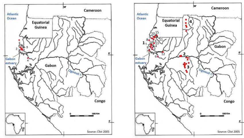
Africa, the cradle of human diversity, Chapter 3 : From the Stone Age to the Iron Age in West- 2
Central Africa – July 4, 2021
the only 4 complete sequences known today. Blue squares are some of the villages dated before
and around 2,000 BP. (Figure by B. Clist).
Central Africa includes eight countries: Cameroon; Central African Republic (CAR); Sao
Tomé and Principe; Equatorial Guinea; Gabon; Congo; Democratic Republic of Congo (DRC); and
Angola (Figure 3.1). If we consider only the major fluvial basins in between plateaus and high
ranges to the north, east and south (Lanfranchi & Schwartz 1990: 5-67; Lanfranchi & Clist 1991:
5-54), we can exclude northern Cameroon and northern CAR (associated with the Sahel region),
southern Angola south of Lobito, and Zambia (oriented towards southern Africa). Different types
of forests cover the landscape, with wooded savannas and woodlands extending to the north and
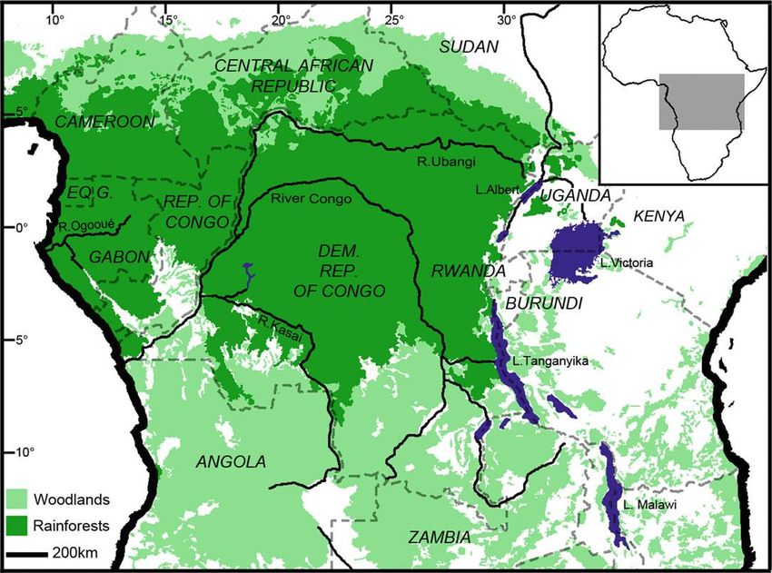
south around the Congo and Ogooué River basins (Figure 3.2).
Figure 3.2 Rainforests and woodlands modern extension in Central Africa (Figure from
Taylor 2016, fig.15.1).
3.2 Climatic changes
According to paleo-environmental data, dry climate periods with open savanna-like vegetation
alternated with a warmer, humid climate and more forested vegetation during the Late
Pleistocene and the following Holocene. Research at Bambili Lake in Cameroon (Lézine et al.
2019), supported by long-term pollen profiles onshore and offshore in Cameroon and offshore in
Angola (Dupont et al. 2008, Lébamba et al. 2012, Lézine & Cazet 2005, Maley & Brenac 1998),
document these changes. The Bambili evidence shows the expansion of forests before 82,000 BP,
then between 80,000-75,000 BP, 53,000-38,000 BP, and 20,000-5,000 BP (Figure 3.3). The
80,000-75,000 BP period was of similar amplitude as at the Pleistocene-Holocene boundary (c.
12,000 BP), both with higher tree-pollen counts than today. The well-known ‘Stone Lines’ were
formed during the transition from dry to humid periods: increasing rainfall on savanna or
wooded savanna let heavier components (‘stone’) move down-slope to form concentrations
(‘lines’). Sangoan and Lupemban tools are found in or on the stone-lines (e.g. Bayle des Hermens
et al. 1987; Mercader et al. 2002).
A severe transition separates the Pleistocene from the Holocene, characterized by tropical
forests expanding (starting around 20,000 BP, Figure 3.3), and the Atlantic Ocean rising enough
to submerge coastal Stone Age sites. This humid climate persisted until c. 3,000 BP when
savannas expanded due to a severe dry period, known as the Late Holocene Forest Crisis (LHFC),
ending around 2,000 BP (Maley et al. 2018). The mechanism of this major vegetation change is
felt earlier, c. 5,000 BP, with the slow lowering of the Sinnda and Kitina lakes in Congo (Schwartz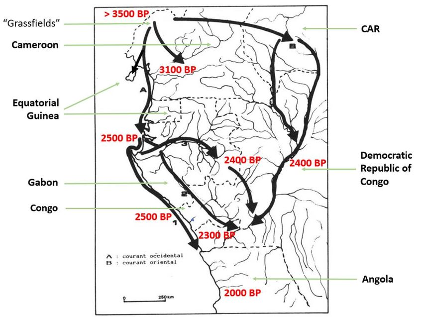
Africa, the cradle of human diversity, Chapter 3 : From the Stone Age to the Iron Age in West-    3
Central Africa – July 4, 2021
et al. 2000). It is around the start of the LHFC that several waves of low-density stone and pottery
using villagers inhabited the west, but the first movements southwards from Cameroon happened
before the forest regression. Other groups of people, this time iron-using and/or metallurgists
(de Maret 2013), followed several centuries later.

Figure 3.3       Palaeoenvironmental sequence of 90,000 years from Bambili lake, Cameroon. The
tree pollen is illustrated in green, the other pollen in white. The black horizontal dotted line
represents the modern level of the tree pollen. The vertical dotted red line marks the arrival of
the first pottery using villages in the Cameroon/Gabon area circa 3,000 BP (Figure from Lézine
et al. 2019, fig.3, adaptation by B. Clist).

        We need more local studies to establish the way local climate and vegetation changed
following the trend we have outlined. On available data about the LHFC, vast expanses of savanna
appear to have surrounded forest refuges (Maley 1987; Schwartz 1991), creating a 400 km wide
Sangha River Interval (SRI), a corridor that enabled Early Iron Age (EIA) peoples and Bantu-
speakers (Bostoen et al. 2015, Grollemund et al. 2015) to expand more easily through the region’s
dense vegetation (Schwartz 1992). Other data, however, show that forests persisted in this
corridor (Brncic et al. 2007, 2009, Kiahtipes 2016; Brémond et al. 2017; Tovar et al. 2019). A
recent reassessment concluded the SRI was covered by forests (Giresse et al. 2020).
Archaeological evidence does not show any settlement in the SRI before 2,020 BP for the Pikunda-
Munda Group (Seidensticker 2016) or before 2,130 BP to the north (Morin-Rivat et al. 2014),
while on the western fringe of the SRI no settlement existed before c. 2,260 BP (Morin-Rivat et al.
2014, 2016). This re-evaluation strengthens our modelling of the EIA and illustrates a large-scale
movement of various peoples between about 2,200 and 2,000 BP from Cameroon to the DRC,
mainly through the forests, and without using the SRI as it was stated a few years ago (see below).
        Figure 3.3 illustrates the speed of vegetation changes for humans who had to adapt
accordingly to the new climatic conditions, the changing position and availability of the animals
they were hunting, and the fruit trees and tubers they were collecting. We can suggest that
climate-induced movements of hunter-gatherer groups sometimes led to their physical
interaction.
        Local palaeoenvironemental sequences must also reach into the EIA and the Late Iron Age
(LIA). Several short-term studies with a high resolution already exist (e.g. Ngomanda et al. 2005,
2007; Brnic et al. 2009). We have to determine if the ‘Medieval Warm Period’ (or ‘Medieval
Climate Optimum’) of AD 950 to 1250 and the colder ‘Little Ice Age’ of AD 1270 to 1850 impacted
human societies through increasing or decreasing food production yields. Perhaps the ‘Little Ice
Age’ contributed to the rise of the Kongo kingdom as a response to agricultural stress, as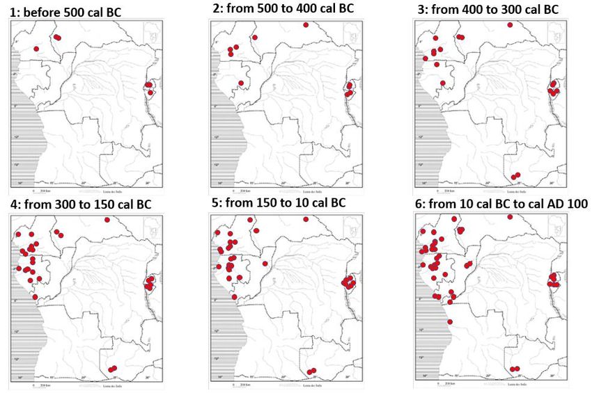
Africa, the cradle of human diversity, Chapter 3 : From the Stone Age to the Iron Age in West-   4
Central Africa – July 4, 2021
illustrated by the drop in rainfall between AD 1400 and 1700 recorded at Kamalete Lake in Gabon
(Ngomanda et al. 2005). Potential reactions of a society facing an ecological or economic crisis
are, amongst several, changes in social organization.

       3.3     Hunter-gatherers

The succession of an Early, Middle, and Later Stone Age was long considered as being
chronological markers through the Pleistocene and Holocene, following a simple evolutionist
perspective. Chronology went hand in hand with technological development, from the pre-
Acheulean to the Later Stone Age (LSA). Since the 1980s, we acknowledge the complex reality
and differences in stone industries.
       The Middle Stone Age (MSA) is characterized by tools struck from carefully prepared
Levallois cores, dated from 300,000 BP (Taylor 2014). It witnessed the co-occurrence of diverse
lithic reduction strategies, including bifacial prepared core technique, blade and backed blade
technologies (Cornelissen 2016; Taylor 2016; Lanfranchi and Clist 1991: 55-95), and ending with
a major size reduction to microlithic assemblages in the Holocene (see Lanfranchi and Clist 1991:
97-132). We now know that LSA assemblages co-existed alongside MSA assemblages before
30,000 BP (e.g. Matupi cave in the DRC and Shum Laka rock shelter in Cameroon; Cornelissen
2016 and our Figure 3.4).

Figure 3.4     Spatial extension of the known Stone industries from West-Central Africa. 1:
Bifacial tradition of the Sangoan, Lupemban, and Tshitolean industries, 2: Middle Stone Age
occupations with, and Holocene microlithic industries without bifacially flaked implements, 3:
Middle Stone Age occupations without bifacially flaked implements, 4: Pre-Holocene microlithic
industries, 5: Holocene microlithic industries without a bifacial component, 6: Holocene
microlithic industries (Figure based on Cornelissen 1997, fig. 30, adapted by B. Clist).

       While in some parts of Central Africa, it is only with the Pleistocene/Holocene climate
transition we witness a transformation of tool kits, from bifacial to microlithic components, in
other areas microlithic industries existed throughout the MSA (Cornelissen 1997). People used
several “chaînes opératoires”, or production sequences, to create various tool-kits, suggesting
several historical trajectories and therefore several co-existing human groups. They appear not
to be in close proximity to one another, but this observation is probably due to uneven
archaeological fieldwork.
       During pre-Holocene times, while hunter-gatherers had microlithic techniques in the
northwest and eastern parts of the region (Figure 3.4, n°4 and Figure 3.5), others used macrolithic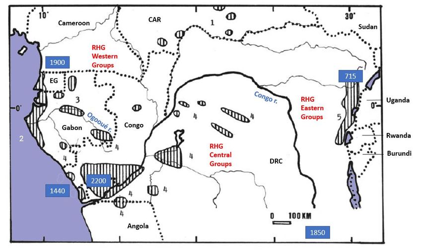
Africa, the cradle of human diversity, Chapter 3 : From the Stone Age to the Iron Age in West-      5
Central Africa – July 4, 2021
bifacial techniques in Gabon and the DRC (Figure 3.4, n°1-2 and Figure 3.5). Later in the Holocene,
the other communities turned to microlithic production techniques. Diversity was maintained
with specific innovations entering the toolkits, for example in the Grassfields of Cameroon, such
as polished stone tools from c. 7,000-6,000 BP, and pottery from 5,000-4,000 BP (Figure 3.6).
Serious climatic deterioration around 7,100–6,900 BP in the Sahara and the Sahel appears to have
caused new communities to slowly settle the Grassfields and introduce these new technologies
(Bostoen et al. 2015: 362).

Figure 3.5       Pleistocene stone industries of Central Africa. Pleistocene stone industries of
Central Africa: upper left, Sangoan from Gabon (Locko 1991a: 68-69); upper right, Lupemban
from the DRC (Muya 1991a: 79); lower left, microlithic from Matupi cave, DRC (Muya 1991b:
119); lower right, microlithic from Shum Laka rockshelter, Cameroon (Cornelissen 2003: 15,
fig.8).

Figure 3.6       Holocene stone industries of Central Africa. Upper left, north-west Gabon (Locko
1991b: 110); upper right, plateau Bateke, DRC (Muya 1991b: 120); lower left and right, Shum
Laka, Cameroon (Lavachery 1996, 1998 & adapted in Clist 2006).

          3.4    Genetic background of hunter-gatherers

Generally, other than caves and rock shelters, environmental conditions are not conducive to the
preservation of animal and human bones. The acidic soils of open-air sites often do not permit
preservation beyond 400 years (e.g. Linseele 2018 for the Kongo Central province of western
DRC), unless exceptional chemical peculiarities exist in places such as pits (e.g. Nkang in
Cameroon and Toubé in Gabon, Van Neer 2000) or decomposing iron objects preserving pieces
of bone or teeth in burials (e.g. Corisco Island, Gonzalez-Ruibal et al. 2013). Because of the paucity
of research relating to the Stone Ages, few sites have yielded human remains, and even fewer have
been genetically analyzed (animals: see Van Neer 1990, 1991, 2000; humans: see Asombang
1988, Van Neer & Lanfranchi 1985: 354, Mercader et al. 2001, Ribot et al. 2001, Crevecoeur et al.
2016; genetics: see Lipson et al. 2020, Wang et al. 2020).
          This is why genetic studies turn to modern populations, especially rainforest hunter-
gatherers (RHG), likely descendants of MSA and LSA communities of Central Africa. These studies
suggest that the RHG split off from the main Homo sapiens lineage over 100,000 years ago (Lopez
et al. 2019), diverging into the modern western and eastern Batwa some 20,000 years ago, with
further internal differentiation amongst the western groups from 3,000 BP (Verdu et al. 2009).
Some evidence indicates a lack of interaction between villagers and hunter-gatherers before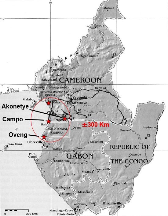
Africa, the cradle of human diversity, Chapter 3 : From the Stone Age to the Iron Age in West-   6
Central Africa – July 4, 2021
1,000 years ago (Verdu et al. 2014), and internal differentiation would then not be related to
villager/hunter-gatherer contact. Significantly, the location of modern RHG groups correlates
with some LSA cultures (Figure 3.7). The western groups north of the Congo River (Bezan, Kola
/ Gyeli, Baka, Aka, Koya / Kola, Bongo, and Barimba) are in the same area as the ancient Atlantic
coastal and Tshitolean LSA industries; the central groups (Twa and Cwa) south of the Congo River
correlate with other Tshitolean sites; and the eastern groups (Asua, Sua, Efe, Twa), located in
eastern DRC and East Africa, have a stronger spatial relationship with LSA industries typologically
related to East Africa (Lanfranchi 1991a; Muya Wa Bitanko Kamuanga 1991b). In this context,
the aDNA analysis of a 750 year-old hunter-gatherer from the Matangai Turu rock shelter in the
north-eastern part of the DRC (Mercader et al. 2001) indicates a possible relationship with
Pastoral Neolithic peoples from East Africa (Wang et al. 2020).

Figure 3.7     Holocene Late Stone Age cultures and latest stone-using hunter-gatherers. 1: CAR
sites, 2: Coastal sites of Equatorial Guinea and Gabon, 3: Dual influence sites in Gabon (coastal &
Tshitolean), 4: Tshitolean, Congo and the DRC, 5: East Africa related sites, 6: Grassfields of
Cameroon (Figure adapted from Clist 1995: 218, fig. 73).

       3.5     Probable interaction between late hunter-gatherers and the earliest villagers

Excavations in Central Africa have revealed stone-using peoples with stone-knapping techniques
identical to LSA industries living near early villages and dated in the same time range (i.e. after
3,000 BP). Sometimes, Iron Age potsherds and/or iron tools are also associated with lithics. The
youngest of such interactions may be dated to around 700 BP in the Ituri forest of northeastern
DRC (Mercader et al. 2000). But a few others exist (Figure 3.7): Ndtoua rockshelter at c. 1,900 BP
(Lavachery et al. 2005: 182) and Mbol at c. 1,870 BP (Morin-Rivat et al. 2014), both in southern
Cameroon, the Moulandou-Fouala site in Gabon at c. 1672 BP (Livingstone Smith et al. 2007: 27),
Kouilou River area in Congo at c. 1,240 BP (Lanfranchi 1991b: 172), eastern Mayumbe range in
the DRC at c. 2,200 BP (Clist, Bigohe et al. 2018: 16-17), Upemba depression in the Katanga
province in the DRC c. 1,850 BP (Cahen 1975), and several others in Gabon (Clist 2006a: 300).
The overall picture seems to be a gradual disappearance of stone working after contact with the
first villagers, with differing scenarios as southwards moving villagers entered new territories.
Two sites strengthen our observation, with continuous use of stone knapping since thousands of
years ago and into the Iron Age: the Nangara-Komba and Shum Laka rockshelters, respectively in the
CAR and in Cameroon.
       At Nangara-Komba, the earliest Stone Age layers are dated to c. 6,100 BP and the quartz
components are followed up to c. 200 BP (Lupo et al 2021). They are coming mostly from small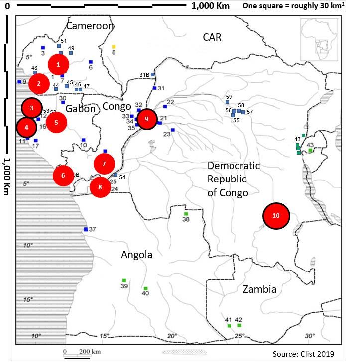
Africa, the cradle of human diversity, Chapter 3 : From the Stone Age to the Iron Age in West-       7
Central Africa – July 4, 2021

quartz and quartzite cobbles, producing microlithic assemblages under 4 cm size with rare
tools. There is no significant change in the knapping technology throughout the deposit, from
c. 6,100 BP to historical times (Ibid.). Pottery was probably imported from neighboring villages
to the hunter-gatherer groups occupying the rock shelter during the later stages of its use,
certainly since c. 2,400 BP, perhaps since c. 2,800 BP (Ibid.); some potsherds are decorated with
rocking comb impressions, a technique similar to contemporaneous pre-metallurgical villages known
in southern Cameroon.
        The Shum Laka rockshelter in the Cameroon Grassfields (Figure 3.7, n°6) provides
evidence of hunter-gatherers with polished stone tools since 7,000-6,000 BP and pottery from
around 5,000-4,000 BP (Lavachery 1996, 1998, 2001, 2003; Lavachery and Cornelissen 2000;
Lavachery et al. 1996). On the basis of reconstructed vocabulary, proto-Bantu speakers knew
pottery (Bostoen 2007), and researchers have considered the Shum Laka artifacts as
representative of the original proto-Bantu toolkit (de Maret et al. 1987; see also Bostoen et al.
2015 for the latest). A recent genetic study on four individuals from burials dated to around 7,000
and 3,000 BP, however, concludes that “these individuals are not representative of the primary
source population(s) that were ancestral to present-day Bantu-speakers” (Lipson et al. 2020).
These people were therefore stone-using hunter-gatherers, and up to 3,000 BP, did not have any
physical interaction with villagers using pottery. Later, after 2,150 BP, iron tools and roulette
decorated pottery were used together with the same LSA lithics. Neighboring Iron Age villages
probably supplied these hunter-gatherers with a few pots. This explains why some researchers
have noted a discrepancy between the developed LSA lithics of the Grassfields sites and the poor
stone tools in the first villages in southern Cameroon: “il est impossible de comprendre, dans l’état
actuel de notre ignorance, comment les préhistoriques sont passés de la confection d’une
industrie lithique assez élaborée dans les Grassfields à celle d’une industrie très simple autour de
Yaoundé” (Clist 2006b: 380). The re-evaluation of the late Grassfields LSA sites brings into focus
an important research question: did people really establish villages in the Grassfields area, as a
pit with pottery similar to the Obobogo Group of the Yaoundé area (Schmidt and Asombang 1990:
14-15) and the few potsherds at Shum Laka and Fiye Nkwi rockshelters suggest (Asombang 1988,
Schmidt and Asombang 1990)? The alternative would be the pottery are imports from outlying
villages to LSA communities. Renewed research is needed in the Grassfields, and to the south, to
look for these early villages (though for the time being, due to social unrest, this is not possible).

        3.6     Rock art

Rock art is known throughout the region, although it has been studied in a very uneven way.
Several styles, with differing techniques, are located on different surfaces, such as caves and rock-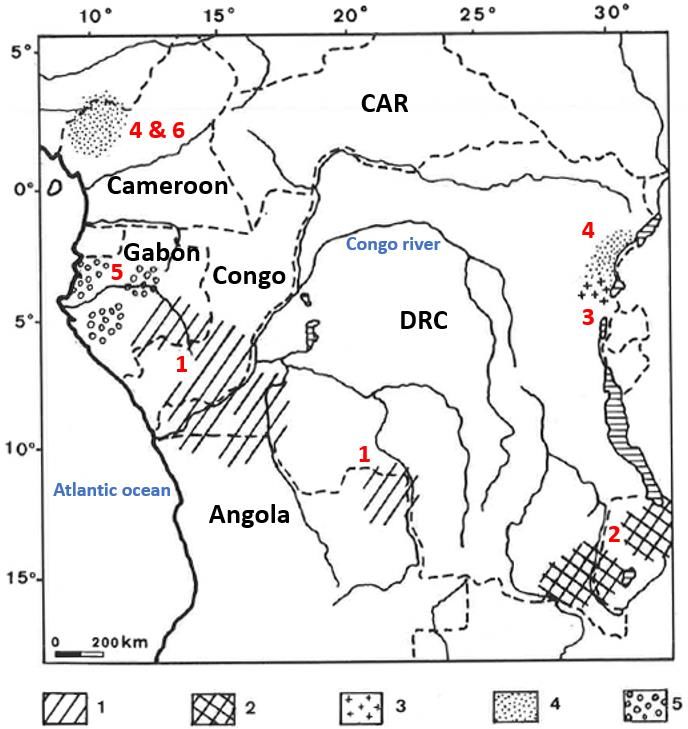
Africa, the cradle of human diversity, Chapter 3 : From the Stone Age to the Iron Age in West-     8
Central Africa – July 4, 2021
shelters walls and open air slabs and boulders (de Maret 1982; Loumpet Galitzine 1992).
Possibly, open-air rock engravings were also painted, like the better preserved images in rock
shelters in Congo and Angola (Ervedosa 1980: 233-391; Lanfranchi 1985; Gutierrez 1996). Since
the mid-1990s, research has led to new discoveries, re-interpretations of old data, and
Accelerator Mass Spectrometry (AMS) dating. The latter has been put to use in the CAR at the
Nangara-Komba site with a date to c. 500 BP (Lupo et al. 2021: 10, table 1), in the western DRC where
paintings are dated to the LIA and the time of the Kongo kingdom (Heimlich 2017), at the
Ndalambiri site of west-central Angola dated to c. 80 BP (Rosina et al. 2018) and at the
Tchitundo-Hulo Opeleva site in southwest Angola dated to c. 1980 BP (Gutierrez 1996: 190)
where it relates to the LSA or possibly to the EIA.
        The various rock art styles probably belong to at least two periods, as they do in Gabon
(Clist 1995a: 184-197, 2005: 533-540), or in Angola (Martins 2014). They are thus also a marker
of regional social diversity. We must reinterpret them and test their fit with the pottery sequences
we now have, after having untangled their chronology and styles based on updated national
catalogues (Angola—Ervedosa 1980: 233-391 and Gutierrez 1996; Cameroon—Loumpet-
Galitzine 1998 and Tchandeu 2016; CAR—Bayle des Hermens 1975: 265-277, 1984 and Clist
1991: 199-201; Congo—Lanfranchi 1985 and Mongolo Mololi 2012, 2013; DRC—Mortelmans
1952 and Heimlich 2017; Gabon—Oslisly and Peyrot 1993, Clist 1995: 184-197 and Oslisly 2016;
Equatorial Guinea—Perramon Marti 1968 and Clist 2020).

        3.7     Interaction among early villagers

Since the late 1950s, archaeology has been linked with linguistics to study the southern expansion
of Bantu-speakers whose homeland was located astride the Cross River in Nigeria and the
Grassfields of Cameroon (Bostoen 2018). At present, it is only from southern Cameroon that one
can document two movements of villagers, not yet using iron tools, between about 3,000 and
2,300 BP (Figure 3.8). These movements connect southern Cameroon to the Congo River along
some 1,000 km of mainly forest with some interspersed savannas (Clist 2006a, 2006b).
        The first and earlier movement seems to have followed the Atlantic Coast between 3,000
and 2,500 BP, linking the Obobogo (Cameroon), Okala (Gabon), and early Tchissanga (Congo)
Traditions, or Groups (Figure 3.8, group A) (Nlend Nlend 2014; Clist 2005; Denbow 2014). Later,
around 2,500-2,300 BP, a second movement with different pottery links the late Tchissanga
(Congo) and the Ngovo (DRC) Traditions (Denbow 2014; de Maret 1986). We do not yet
understand the connection, if any, with the first incomers and between them. Based on the
distribution of the Okala Group, people probably travelled up the Ogooué River from the Atlantic
coastline to reach Franceville and the savannas astride the Gabon-Congo border about 550 km to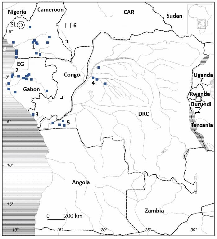
Africa, the cradle of human diversity, Chapter 3 : From the Stone Age to the Iron Age in West-   9
Central Africa – July 4, 2021
the southeast (Figure 3.8). The Okala evidence consists of a pit at Franceville dated to 2,440 BP,
an undated archaeological layer at Massango with pottery and polished stone tools, and surface
finds of dozens of polished stone adzes and axes in the province (Clist 1995: 147-149).

Figure 3.8      Probable axes of expansion of the first villagers in West-Central Africa. General
timeline, the “A group” following the Atlantic Ocean coastline. The “B group” probably went
through the forest and not along rivers as shown (Marchal-Nasse 1991: 142, fig.4, a map made by
B. Clist – adapted 2019 by B. Clist).

        We still do not understand what happened there later, when iron smelting started in
Moanda about 2,350 BP associated with a pottery study as yet unpublished (Jézégou and Clist
1991), and with a pit at Djambala 200 km to the southeast on the Bateke Plateaux in Congo dated
to 2,300 BP, containing pottery but without evidence of iron working (Lanfranchi 1991b: 172-
173). Given that the Bateke Plateaux was not settled by iron-using villagers until 1,900 BP (Dupré
and Pinçon 1997: 37-59), this data may represent a third axis of movement, from the north
through the forests. Such a third axis is also suggested by the sites of Oyem (2,280-2,220 BP) and
Koualessis (2,100-1900 BP) in northern Gabon, and Okanda near the Ogooué River (c. 2,110 BP)
where iron smelting was practiced (Clist 1989a: 81-83, 2005: 773-777). While iron metallurgy
developed at Moanda and then slightly later in Oyem and central Gabon, the Okala Group material
culture continued on the coast and in the middle reaches of the Ogooué River without evidence
of iron production, though it probably imported iron tools from the inland production centers c.
2,370-2,200 BP (Clist 2005). Iron-working expanded on later with the establishment along the
coast of Gabon and Equatorial Guinea of the Oveng Group from about 2,000 BP (Sánchez-Elipe
Lorente et al. 2016, and see below).
        Far to the east, iron-producing Urewe Tradition sites are known in Kivu (DRC) (Hiernaux
& Maquet 1960), possibly dating to 2,800-2,500 BP and the highlands of the Interlacustrine area
in Rwanda, Burundi, and Tanzania (Clist 1987, 2013: 26) (Figure 3.9). The geographical isolation
at 2,300 BP of the 'neolithic' villages in Cameroon, Gabon, and Congo, slowly expanding to the east
and south, from the Urewe Tradition iron-producing settlements, is enough evidence to underline
they are quite probably the result of two contemporaneous and separate social developments
(Figure 3.9 and Ehret 2015).

Figure 3.9      Pre-metallurgical villages maximum extension around 2,300 BP. SL: Shum Laka
rockshelter and Grassfields. 1: Obobogo Group. 2: Okala Group. 3: Tchissanga Group. 4: Imbonga
Group. 5: Ngovo Group. 6: Bouar area Neolithic and megaliths. 7: Early Iron Age Urewe Group
(adapted from Clist 2005: 722, fig.8-11).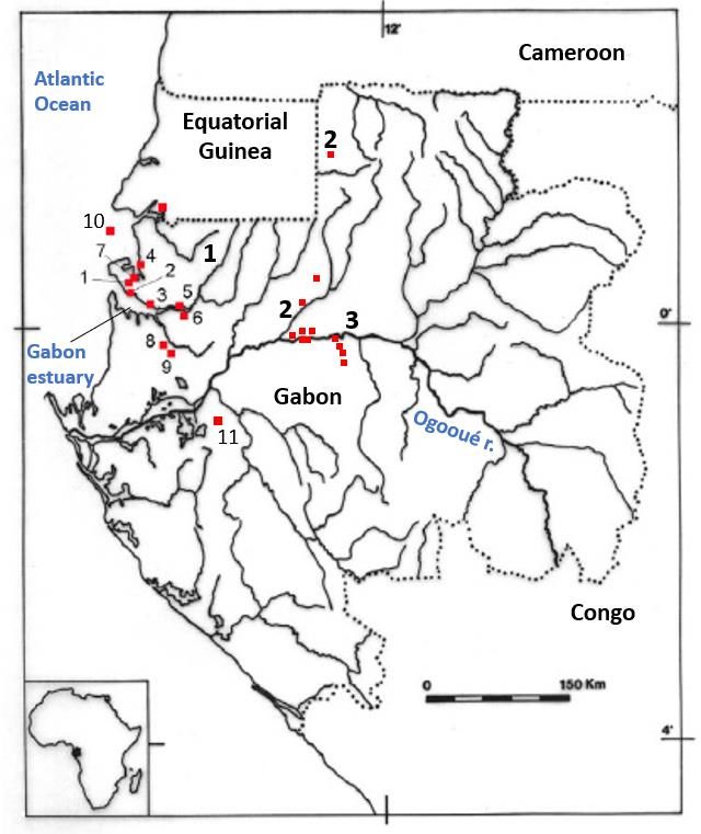
Africa, the cradle of human diversity, Chapter 3 : From the Stone Age to the Iron Age in West-   10
Central Africa – July 4, 2021

       We now know of another and distinct group of pottery-using villagers who may be moved
upstream through the forest along the Congo River, reaching east to the Kisangani area by 2,100
BP (Livingstone Smith et al. 2017). If so, they may be related to the Imbonga Group located near
Mbandaka on the Congo River, first dated to around 2,400 BP (Figure 3.8. Eggert 1987, 1994-
1995; Wotzka 1995; Seidensticker 2016). The only possible origin for Imbonga communities in
southeastern Cameroon, even though preliminary research there and neighboring Congo has not
found any connections (Seidensticker 2016). But we cannot exclude the sites found around
Kisangani relate to people arriving to the Congo river through the forests of its north bank.
Ongoing research will certainly make the situation clearer in the years to come.

       3.8     Iron working

Two sets of facts from archaeology and historical linguistics must be considered to ascertain if
the diffusion of iron working can be explained as an independent factor parallel to the expansion
of the various EIA peoples. Historical linguistics told us long ago that metallurgy was not known
to proto-Bantu when they resided in the Cross River of Nigeria and the Grassfields of Cameroon
(de Maret & Nsukka 1977, Nsuka-Nkutsi & de Maret 1982). Iron was a later introduction to
Central Africa from the northwest, from Nigeria and Cameroon (Vansina 2006), which spread
southwards (Clist 2012, 2013; Eggert 2014).
       The earliest iron smelting centers developed in the north before 2,600 BP in the western
CAR (Figure 3.10, n°1: Gbabiri in western CAR – 2,640 BP), before being attested in southern
Cameroon (Zili – 2,630 BP, Figure 3.10, n°2), and around 2,300 BP in southeastern Gabon
(Moanda – 2,350 BP, Figure 3.10, n°3). Iron smelting then spread south and eastwards (Figure
3.10, n°4 and 5) before ultimately reaching the Congo River and the Luanda area of Angola around
1,900 BP (Figure 3.10, n°6). Once again, now using the respective chronology of west-central
Africa’s early iron-working centers and of the iron-producing Urewe Tradition of the Great Lakes
area of eastern Africa (Clist 1987), we are left with the absence of any possible relationship
between the two regions (Figure 3.10, n°1).
       No metallurgical analyses have been published from metallurgical sites. Such research is
needed to verify the types of production sequence in the smelting process. We should also
establish the ceramic links to clarify several peculiarities in the data at hand. For example, it is
known the Oveng Group, extending from Equatorial Guinea (Sánchez-Elipe Lorente et al. 2016)
to the south of the Ogooué River in Gabon (Livinstone Smith et al. 2007: 31-34), starts slightly
before the Kay Ladio Group of the Kongo Central Province in the DRC (Clist et al. 2019). Their
respective pottery are strikingly similar in several ways (Figure 3.11). Further investigation is
Africa, the cradle of human diversity, Chapter 3 : From the Stone Age to the Iron Age in West- 11
Central Africa – July 4, 2021
needed in the context of the cultural transitions found between 2,200 BP and 1,900 BP from
southern Cameroon to the western DRC and to the Inner Congo Basin with the development of
the Pikunda-Munda Group at c. 2,000 BP, and further north the Batalimo-Maluba Group at c. 2,140
BP (Clist 2005: vol. 2, appendix 5, tables 9.2 and 9.3; Seidensticker 2016). The latter looks like an
expansion southwards deeper into the rainforest using the Ubangui River from the CAR.
Figure 3.10 Geographical location and chronology of archaeological sites with iron-working
evidence (adapted from Clist 2013, figs.1-6).
Figure 3.11 Pottery from the Oveng and Kay Ladio Groups. 1 & 2 (from Clist 2005): Pottery
from the Oveng Group, c. 2,000-1,300 BP (Gabon), 3 (from Gosselain 1988): Pottery from the Kay
Ladio Group, c. 1,950- 1,650 BP (DRC).
3.9 Cultural transitions
Probably the most fascinating research outcome during the last 40 years is the identification of
cultural transitions (Figure 3.1). This research is often based on PhD projects, most of which
unfortunately remain unpublished.
As previously mentioned, we easily follow Neolithic transitions which are in stark
contrast to LSA traditions. The earliest such transition is slightly older than 3,000 BP in southern
Cameroon, around 2,300 BP on the Congo River in the western DRC, and around 2,400 BP in the
Inner Congo Basin (Figure 3.8).
Though stone-using hunter-gatherers coexisted with villagers from then until modern
times, losing along the way their stone toolkit (Figure 3.7), the Iron Age brought different pottery
traditions. Such Neolithic/Iron Age transitions are situated between 2,200 and 1,900 BP. They
follow an irregular north to south chronological gradient, probably associated with the diffusion
of iron smelting, but also with new waves of people moving towards the Atlantic coast. The spatial
extension of their material culture is more restricted than during the preceding Neolithic, and
shows marked stylistic differences along shorter distances.
These breaks are likely caused by a new human influx, replacing the previous production
sequences, and changing the visual labels for group identification. Research on small cemeteries
in southern Cameroon, southern Equatorial Guinea and northern Gabon revealed important
differences in burial practice together with major changes in pottery production (Cameroon—
Meister 2008, 2010; Meister and Eggert 2008; Eggert et al. 2006; Eggert and Seidensticker 2016.
Equatorial Guinea— Gonzalez-Ruibal et al. 2011, 2013; Sánchez-Elipe Lorente 2015; Gabon—
Peyrot et al. 1990, Clist 1995, 2005; and see below).Africa, the cradle of human diversity, Chapter 3 : From the Stone Age to the Iron Age in West- 12
Central Africa – July 4, 2021
In this respect, four examples stand out illustrating similar scenarios: 1) southern
Equatorial Guinea and northern Gabon; 2) the center of Gabon along the Ogooué River; 3) the
coast of the Congo Republic; and 4) the DRC between Kinshasa and the Atlantic Ocean. We focus
here on the first area, encompassing the Okala, Oveng. Nanda and Angondje groups.
Throughout our review, we consider if one component is found on one site of a given
cultural group, e.g. within the Okala Group, millet horticulture or stock raising, then it is probable
all the villages of the group knew about it. Most excavations did not use flotation techniques to
register millet seeds, and the soils are too acid to preserve animal bones.
3.10 The Okala Group
It was described early (Clist 1988, 1997) and is now bracketed by 44 radiocarbon dates from
2,460 to 1,870 BP. Okala communities are distributed over about 500 km, from the Gabon Estuary
to Franceville near the Congo border, and southward for about 300 km to the lagoons and forests
south of Port-Gentil (Figure 3.12. See Clist and Jézégou 1991; Clist 1995: 151-153, 2005: 490;
Assoko Ndong 2001, 2003). The sites appear to be true villages with a cluster of
contemporaneous houses spatially organized. Ubiquitous pits of varying volume (from 0.5m 3 to
9m3) yielded fragments of burnt clay walls with pole impressions of the wooden framework.
Some excavations revealed post holes near the pits. These villages seem to extend over large
areas: Kango 5 was 6 ha, while Okala 1 was at least 3.4 ha. Contemporaneous sites in Cameroon
varied from 0.5 ha at Okolo and Ndindan to 1.5 ha at Nkang, 2 ha at Obobogo and 5 ha at Nkométou
(Clist, 1990, p.466; Mbida, 1996, p.643; 2003, p.105). Pit fillings contained several artefact types,
including pottery (sometimes in large numbers), a limited amount of stone tools, and polished
stone adzes and axes, but no evidence of local iron working.
Figure 3.12 Map of the Okala Group sites in Gabon (Map by B. Clist).
Within the characteristic Okala Group style, one decorative element stands out, the
rocking comb, or spatula impressions, often covering the entire pot surface and at least 50% of
the pots flat bottoms (Figure 3.13, lower four). One characteristic shape is the double-curve pot
(Figure 3.13, right, upper two), which is also found in southern Cameroon 180 and 230 km to the
north, at Campo Eglise and Bwambé, respectively. Villages using similar pottery both on the
southern coast of Cameroon and in northwestern Gabon allows us to infer their concomitant
presence on the Equatorial Guinean coast. Indeed, several sites with polished axes and
grindstones have already been documented there (Clist 1998: 215-216). Forthcoming
excavations will provide a clearer picture of the socio-economic connections and exchangeAfrica, the cradle of human diversity, Chapter 3 : From the Stone Age to the Iron Age in West- 13 Central Africa – July 4, 2021 strategies that probably existed prior to 2,200 BP along 300 km of the Atlantic coastline. A close relationship between Okala and Obobogo pottery is already known (Clist 2005: 489-533 for Okala, 721-740 and appendix 5 for Obobogo/Okala). Another study, using material from more recent excavations along the Cameroon coast, showed all the sites before 2,200 BP were associated with the Gabonese Okala Group and formed a larger tradition (Nlend Nlend 2014: 230- 273). Figure 3.13 Okala Group pottery and stone tools (2,460-1,870 BP), Gabon (Clist 2006a, 297, fig.4). While feature 07/11 of Campo Eglise with typical double curve pots is late for the Okala Group 2,185-2,150 BP (Eggert & Seidensticker 2016: 187), the four pits at Bwambé (pits n°12, 16, 19, 33) correspond to an earlier phase, 2,360-2,240 BP (Nlend Nlend 2014). Pit n°33 at Bwambé is very interesting. It is dated three times on millet seeds, palm nuts and charcoal extracted from the same layer in the pit (cf. Nlend Nlend 2014: 147, 167, Table 39 and fig 65; Kahlheber et al. 2014: 115: Erl-9176: 2326±86 BP, Erl-9177: 2305±44 BP, Erl-9177: 2305±44 BP). The fill contained as many shards from the so-called 'Malongo Tradition' as of the 'Bwambé Tradition', which are quite distinct (Nlend Nlend 2014: 148, 250 and Table 34). The ‘Malongo Tradition’ is equivalent to both the Obobogo and Okala Groups, a different label for the same material. Only a close examination of the pottery assemblages can distinguish these two Groups. As the double curve pots are unknown in the Obobogo Group, we can associate the Campo Eglise and Bwambé sites to an Okala cultural context. Millet is also found at Abang Minko'o dated around 2300-2100 BP, about 200 km to the east, with pottery similar to the Obobogo Group (Eggert et al. 2006: 290 and Table 4: 283, pottery see their fig. 7). Millet seeds in Obobogo (Abang Minko’o) and Okala (Bwambé) contexts support the earlier identification of "two charred seeds of Monocotyledone, a grass of the genus Pennisetum sp" (Claes 1985: 137) found in two sherds from pits II (c. 3,055- 3,070 BP) and VII (c. 2,120 BP) at the eponymous Obobogo site and identified by H. Doutrelepont (Ibid.), though the seeds could also have been from the wild variety. The doubts about these identifications (e.g.Wotzka 2019: 411) underline the need to publish these excavations. Of course, renewed fieldwork, this time with systematic flotation, would be better. Unfortunately, the Obobogo potsherds studied by H. Doutrelepont could not be relocated (P. de Maret personal communication). Domesticated millet at c. 3,000 BP contradicts the assumption that millet cultivation was difficult or impossible under rainforest conditions, and was only possible during the LHFC, i.e. after 2,500 BP (Neumann et al. 2012, and see historical development in Wotzka 2019). Wotzka has shown this is not true: millet could be, and has been grown at least until the 14th-16th centuries AD in the
Africa, the cradle of human diversity, Chapter 3 : From the Stone Age to the Iron Age in West-    14
Central Africa – July 4, 2021
humid conditions of the forests (Wotzka 2019: 408 and his location map: 423, fig.7). It “clearly
contradict[s] some of the major ideas held in the literature about a supposed general unsuitability
of rainforest and climatically similar settings for pearl millet cultivation” (Wotzka 2019: 424).
The use of millet may have been more widespread in this cultural context than is currently
recognized due to the lack of the use of systematic flotation (cf. Fuller et al. 2014). We can
conclude millet cultivation was practiced in the Obobogo and Okala Groups, at least from
southern Cameroon to northern Gabon. Its presence suggests former contacts between northwest
Central Africa and the Sahel zone where it was domesticated (Neumann 2018: 8) and cultivated
alongside cowpeas (Vigna unguiculata) in the Gajiganna Tradition and in the Nok culture of
Nigeria (Neumann 2018: 13-14).
       The use of the word *-cángú’, designating finger millet in west Bantu languages, can be
reconstructed for proto-Bantu. But it was probably associated with millet slightly later, after the
start of the Bantu expansion (Bostoen 2006-207). Polished stone axes and adzes, grinding stones
and grinders of the Obobogo and Okala Groups are indirect evidence for horticulture.
       We tested the probability that early villagers chose specific soil types to settle and develop
horticulture and fishing. We used soil maps of the French ‘Bureau de Recherches Géologiques et
Minières, and mapped a 5 km radius around 18 sites of the Okala Group. Six are along the Gabon
estuary, ten along the Ogooué River, and two are the Ofoubou River sites (Figure 3.12, n°13-14).
Although not conclusive, five sites have 80-90% cultivable land, five have 40-60%, seven have 10-
30% and one has none (Otoumbi 13, Ogooué sector) (Clist 2005: 512-516). Fishing was certainly
practised: fifteen sites are situated near the ocean or rivers. Even if communication between
communities played an important role, this proximity to water implies the use of dugout canoes.
Further, an iron fish hook was found in pit n°1 of the Bwambé site in Cameroon, dated to c. 2,200
BP (Nlend Nlend 2014: 258). Prehistoric visits to nearby mangroves is attested by Anadara senilis
shells (adapted to muddy river bottoms and mud flats in mangrove). They were found in pit n°1
of Okala, and were probably collected around 2,230 BP (Clist 2005: 256). Okala Group villagers
also exploited oil-containing tree fruits, such as the oil palm (Elaeis guineensis) and the incense
tree (Canarium schweinfurthii). While Elaeis carbonized endocarps are found in most of the
excavated pits, sometimes by the hundreds as at Okala, Canarium was only found at Toubé on the
Ogooué River. The latter site also yielded carbonized endocarps from Anthrocaryon klaineanum
and Coula edulis, while Panda oleosa was found at Okala and Toubé, and Maranthes polyandra at
Kango. This is evidence for early agroforestry practices. On the Ogooué River, small stock raising
is documented at Toubé 1 (Capra aegagrus f.Hircus), hunting at Otoumbi 13 (Tragelaphus
scriptus and Cephalophus sylvicultor, Assoko Ndong 2002: 141), and at Toubé 1 (Tragelaphus
scriptus and Atilax paludinosus, Assoko Ndong 2001: 230).
       Long-distance exchanges existed. The Okala Group had come from the north and they
Africa, the cradle of human diversity, Chapter 3 : From the Stone Age to the Iron Age in West- 15
Central Africa – July 4, 2021
must have had some knowledge of the lands crossed and kept social relationships with parent
communities. Iron working is not attested on these sites. The two iron artefacts found at Okala
and Lopé are evidence of long-distance contact with iron producing centres, maybe the one at
Moanda some 550 km away. Raw material for the polished stone tools in estuary communities
could have come from 80 km (Kango 5) to 70 km away (Okala 1), while 40 km was needed on the
Ogooué River to reach the stone sources (Ndjolé Pk5). Lastly, the potting clay and temper used
on the coast and along the Ogooué River are different. Several potsherds at the coastal Okala site
may have been imports from inland, 300 km away: “La recette « minérale » quant à elle rappelle
étrangement les productions du centre du Gabon. Là, les sites de la Tradition d’Okala fabriquent
une poterie oxydée, claire, rougeâtre, probablement due à l’importance des oxydes de fer dans les
argiles natives, dont la charge non plastique est composée du cortège minéral local, c’est-à-dire
par ordre décroissant le quartz, le feldspath, le mica et l’amphibolite” (Clist 2005: 422).
3.11 The Oveng Group
Research around the Gabon estuary (Clist 1989a) identified the Oveng Group. This Group extends
from Corisco Island in Equatorial Guinea southwards to the Lambaréné area on the Ogooué River,
230 km away (Clist 1995: 164-167; Livingstone-Smith et al. 2007; Clist 2005: 541-599; Sánchez-
Elipe Lorente 2015: 267-298). Eastwards, its inland extension is unknown, though the
contemporaneous Otoumbi and Okala villages along the Ogooué River (Assoko Ndong 2002,
Oslisly 1986, 1992) and in the forest to the north (Clist 1989a; Oslisly and Assoko Ndong 2006)
using their own pottery show the ‘border’ was somewhere to their west (Figure 3.14). The Oveng
Group is well bracketed by 25 radiocarbon dates between 1,970 and 1,296 BP (an older date, Gif-
8151 2,210 BP, from mangrove Anadara senilis shells is probably too old).
Figure 3.14 Location map of the Oveng (1, from n°1-11), Otoumbi (2), and Okanda Groups (3).
Local iron production started with the Oveng Group around the Gabon estuary, as is the
case inland with the Otoumbi (c. 2,060 BP) and Okanda groups (c. 2,210 BP); all three appear at
the same time, between 2,200 and 2,000 BP. The metallurgical residues and iron implements have
not yet been studied. Based on the 14C dates, Neolithic and EIA settlements probably coexisted for
some time (DIBAC database1). Furthermore, on the coast the Okala Group (youngest date c. 1,870
1
DIBAC : Datations absolues, Inventaires archéologiques et Bibliographies en Afrique Centrale. Absolute dates
database created by B. Clist et R. Lanfranchi in 1987 (Cibadate project: cf. Sarrazin 1987), extended to cultural
resources management and national archaeological bibliographies of Central Africa (Cultural resources
management: Clist 1995, 238-244; absolute dates database: Clist 1995, 259-280 ; bibliographies :
http://www.african-archaeology.net/biblio/index.html). All the 14C data in this paper is taken from DIBAC.Africa, the cradle of human diversity, Chapter 3 : From the Stone Age to the Iron Age in West- 16
Central Africa – July 4, 2021
BP) and Oveng Group (oldest accepted date c. 1,970 BP) overlap, while inland, the Okala Group
(youngest date c. 1,935 BP) seem to have coexisted with the Okanda Group (earliest date c. 2,260
BP).
Vessel shapes are completely different from the preceding Okala tradition, though the
bottoms are still flat. Decoration is limited to the upper parts, from the lip to the upper body, and
new decorative techniques are in use (Figure 3.15, 1). Out of a minimum of 149 vessels at the
Oveng site, only 25% are left undecorated. Of specific visual significance, the impressed comb is
present on 37% of the pots, forming simple oblique or horizontal alignments, sometimes forming
simple or multiple herringbone units (7% and 4% respectively). Rare (n=3 pots), but visually
significant, are the appliqués buttons—small conically shaped pieces of clay forming a single
horizontal line (Figure 3.15, 1). Lips were sometimes decorated by small incisions (Figure 3.15,
1), as in the Otoumbi and Okanda assemblages. Lastly, another and very characteristic tool is the
half-circular stylus (Figure 3.15, 1). It appears at the start of the EIA in all the cultural groups
known in Gabon and used the same way: horizontal single or double lines bordering other
decorative bands (cf. Okanda and Otoumbi groups). In the Oveng Group it is present on 40%-56%
of four of the six known shapes. This tool was used in the contemporaneous “Herringbone”
pottery in Congo (Denbow 2014: 106-135), the Kay Ladio Group in the DRC (Clist et al. 2019) and
in the Campo and Akonétyé groups of Cameroon (Meister and Eggert 2008; Nlend Nlend 2014;
de Saulieu et al. 2015; Eggert and Seidensticker 2016). Some pots were also decorated with it
within the Kribi Group of southern Cameroon (Nlend Nlend 2014).
Evidence for contacts between the Okanda and Oveng groups can be found in a pot
uncovered at Oveng (Clist 2005: 566, fig.7-22, n°8) which is identical in shape and decoration to
another from the Okanda 5 site over 200 km away (Assoko Ndong 2001: 375, pl.38, R23), both
dated to the same period (Figure 3.15, 2a and 2b).
Carbonized endocarps of some fruits were found. As usual, Elaeis guineensis occurs in
higher numbers, but the Oveng site also contained some Antrocaryon klaineanum, Coula edulis
and Panda oleosa carbonized endocarps. Fruit trees as part of the subsistence system may have
been inherited from earlier communities.
Figure 3.15 Oveng Group pottery and burial. Oveng Group, c. 1,970-1,296 BP. 1: pottery,
Oveng and Kafélé sites, Gabon. 2a: Pottery from Oveng, 2b: Pottery from Okanda 5, 3: Burial of the
Oveng Group. (1, 2a & 5: Clist 2005, 2b: Assoko Ndong 2001, 3: Sánchez-Elipe Lorente 2015).
Excavation of the Oveng site added greatly to our knowledge of EIA ecological adaptations
2,000 years ago. For the first time in Central Africa, we had proof of adaptations to mangrove and
ocean ecosystems: villagers fished (a lot), hunted (minimal), collected gastropods and bivalves inAfrica, the cradle of human diversity, Chapter 3 : From the Stone Age to the Iron Age in West- 17
Central Africa – July 4, 2021
the mangroves, and fruits in the forest (a lot). Within their settlements set up in the forest they
processed iron (Clist 1989a, 2005: 541-588, 2006c; Van Neer and Clist 1991; Van Neer 2000: 168
and 170). African manatee (Trichechus senegalensis) alongside fifteen other fish species were
fished in the mangrove rivers and in a nearby estuary, while the python was hunted on land
(Python sp.). Although we systematically water sieved the deposits, we found no evidence of
domestic seeds. Ten circular disc beads were made from shells, probably of Anadara senilis (2.5
to 3.6 mm in diameter, with a thickness from 0.4 to 1.5 mm). The shell beads are similar to others
found at the EIA midden of Cabolombo (ex-Benfica) near Luanda (Angola) dated to c. 1,800 BP
(Santos and Ervedosa 1970; Valdeyron and Domingos 2009, 2012), and to more recent shell
beads at Muanda 6 on the DRC coast dated to c. 1,600 BP (Clist, Bigohe et al. 2018; Clist and Béarez
et al. Forthcoming). Together with the Muanko Lobethal site in Cameroon, dated to between 1950
and 1750 BP which yielded oyster shells (Williams-Schmid 2001; Eggert 2002: 513-521), the
shells attest to a better EIA adaptation to coastal ecosystems compared to Neolithic times.
In 2009, a survey on Corisco Island (Equatorial Guinea) identified important features
impacted by the construction of an airstrip. Several of them were radiocarbon-dated (Gonzalez-
Ruibal et al. 2011). Analysis of the 2011 excavations (Gonzalez-Ruibal et al. 2013; Sánchez-Elipe
Lorente 2015) revealed interesting burial practices of the Oveng (Figure 3.15, n°3) and Nanda
groups that are similar, but different from contemporaneous burials in southern Cameroon
(Meister 2008, 2010; Meister and Eggert 2008; Eggert and Seidensticker 2016). The iron artefacts
from 22 Oveng burials comprise axes, bikuele (traditional iron currency used in the LIA with
exactly the same shape), bracelets, knives, necklaces, rings and spoons. They number from zero
(4 burials) to nine per feature; exceptionally one had 14 and another 27. One iron necklace from
burial n°20 had a bone fragment preserved by the decomposed metal; other pieces of human bone
were also found in another three deposits (Gonzalez-Ruibal et al. 2013; Sánchez-Elipe Lorente
2015). Whole pots occurred in burials without iron implements, while 15 burials with metal
lacked pots. In the remaining seven burials, the pots number from one to five (Gonzalez-Ruibal et
al. 2013; Sánchez-Elipe Lorente 2015, and our Figure 3.15, n°3). The cemeteries in Cameroon
consisted of primary burials in oval-shaped pits, while on Corisco there were secondary burials
in circular pits, though two elongated pits were also documented. Further, some types of iron
artefacts were found in Cameroon but absent in Equatorial Guinea. The associated pottery was
inverted in Cameroon, while they were upright on Corisco Island. The pottery found in the burials
helped to identify the Akonétyé, Campo, and Oveng stylistic zones. Significant similarities
between the three zones over about 300 km include iron artefacts, such as spoons, anklets, axes
with widened cutting edge, and bundled iron pieces interpreted as special purpose currency. But
comparisons between Akonetye, Campo and Mouanko Lobethal in Cameroon (Figure 3.16) show
they form a group quite distinct from Nanda in Equatorial Guinea (Meister 2010). A previous findAfrica, the cradle of human diversity, Chapter 3 : From the Stone Age to the Iron Age in West- 18
Central Africa – July 4, 2021
in the suburbs of Yaoundé, at Obobogo, was probably part of a cemetery similar to the other sites
in Cameroon (Meister 2010: 239-240).
Figure 3.16 Position of the four cemeteries associated with the Oveng, Campo, and Akonetye
Groups (adapted from Eggert et al 2006: 280, fig.2).
The emergence of inequalities and the development of inegalitarian polities in sub-
Saharan Africa will eventually be found in the northwestern part of Central Africa, from Cameroon
to Gabon. Indeed, the political and symbolic relevance of iron to wives and wealth is probably
much older than previously thought (Gonzalez-Ruibal et al. 2013; Eggert and Seidensticker
2016). Taking into account the oldest Nanda burials, we can push back to the 1 st century AD the
development of prestige goods to enhance political formations (Vansina 1990, 1999; McIntosh
1999; de Maret 2012). The possible historical relationship between the EIA Groups of southern
Cameroon, Equatorial Guinea and Gabon with more recent peoples south of the rainforests
suggests these emerging traditions could have been implicated in the rise of the Kongo kingdom
(de Maret 1999, 2018; de Maret et al. 2018; Clist, de Maret et al. 2018a, 2018b).
We must now consider the Otoumbi Group in central Gabon dated from c. 2,000 BP.
Though identified some time ago, we can only call attention to the similarity between Otoumbi
and Oveng pottery, in contrast to Okanda ware. Its corpus of 11 14C dates, together with 18 from
the Okanda Group, and the respective distribution maps, show that Okanda preceded Otoumbi.
Later, Okanda settlements moved further east, while Otoumbi communities expanded in their
sector. The Oyem EIA site located 180 km north, dates to 2,200 BP, has pottery similar to Otoumbi
and suggest this Group may have come from the forests at the Cameroon-Gabon border (Figure
3.14).
Figure 3.17 Location map of Late Iron Age Groups in Gabon. Sites from the Nanda Group, c.
1,360-907 BP (left) and from the Angondjé Group, c. 985-440 BP (right, n°1). Also illustrated, the
Lopé Group (n°2), the Leledi Group (n°3), and LIA dated sites near Oyem (n°4).
3.12 The Nanda and Angondjé Groups
These two groups in northwest Gabon were originally called ‘Groupe II’ and Angondjé Group
(Figure 3.17) (Clist 1995: 167-168 and 168-169, 1995b: 18-20; Sánchez-Elipe Lorente 2015;
Sánchez-Elipe Lorente et al. 2016). The Nanda Group (formerly Groupe II) is dated by ten 14C
results from 1,360 to 907 BP and the Angondjé Group by eight dates from . 985 to 440 BP.
However, it has been suggested the two cultural groups may be two sides of the same coin. AfterAfrica, the cradle of human diversity, Chapter 3 : From the Stone Age to the Iron Age in West- 19
Central Africa – July 4, 2021
having stated “the small number of radiocarbon dates from Gabon associated with the Nandá
tradition and the larger assemblage of dates from Corisco suggest that the traditions coexisted, at
least in Corisco” (Sánchez-Elipe Lorente et al. 2016: 364), he further suggested “the pottery
traditions Nandá and Angondjé do not represent two different human groups; rather, they belong
to the same tradition but relate to two different communities of practice – everyday life and
burial” (2016: 364-365).
Figure 3.18 Nanda Group pottery and iron artefacts from burials. Nanda Group, c. 1,360-907
BP. 1. Pottery from the ‘Sablières’, Gabon (n°1-3) and from Corisco Island, Equatorial Guinea (n°4-
5) (Clist 2005, Sánchez-Elipe Lorente 2015). 2. Burial n°9 from Corisco Island (Gonzalez-Ruibal
et al. 2013, 137, fig.17). 3: Iron artefacts from burials n°26, Corisco Island (Sánchez-Elipe Lorente
2015).
3.13 The Nanda Group
The 16 Nanda burials on Corisco Island yielded iron artefacts and pottery (Figure 3.18, n°1-3).
They contained from zero (5 features) to 12 iron objects. All of them had pottery, mostly from
one to eight vessels, while one with 18 pots also contained six iron objects. The iron artefacts
consisted of anklets, axes, small bell (1), bracelets, necklaces, and knives (Figure 3.18, n°3). The
number of iron artefacts is less and the pottery more abundant than during Oveng times. Pottery
assemblages are limited to a few jars (Figure 3.18, n°1, 2 and 4) and many bottles (Figure 3.18,
n°3 and 5). The types of metal and pottery offerings are different from the Oveng Group, and we
have no evidence for the exploitation of local mangroves. The corpses were set the head to the
southwest, feet to the northeast, with bent arms and hands placed on the chest and belly
(Gonzalez-Ruibal et al. 2013: 136). The pottery, especially the bottles, may have been produced
specifically for funerary purposes because “the pots were barely fired and they crumble easily
when they are removed from their original position; on the other hand, it seems that they were
made quickly, as proved by the deficiencies in the modeling (using coils) and, especially, the often
clumsy decoration” (Gonzalez-Ruibal et al. 2013: 138). At the ‘Sablières’ site in Gabon, however,
all pottery was well made and finely decorated (Peyrot et al. 1990; Clist 2005: 600-614). One of
these pots was found on the northern part of Bioko Island (Peyrot et al. 1990: 496). When it was
published, a connection to Nigeria was suggested (Martin del Molino 1965: 26 and fig. 10B).
Instead, this is evidence for long-distance contact between Bioko and Nanda coastal villages,
probably located around the Rio Muni or the Gabon estuary. This find strengthens cultural links
over some 300 km between southern Cameroon and the Equatorial Guinea-Gabon border (Figure
3.16), and, notably, highlights long-distance contacts since the Neolithic, 1,000 years previously.You can also read