VViiccttoorriiaann SSuupppplleemmeenntt 22000044 - Victoria - state of activity - www.dpi.vic.gov.auminpet
←
→
Page content transcription
If your browser does not render page correctly, please read the page content below

Victorian Supplement 2004
 Victoria - state of activity

     www.dpi.vic.gov.au/minpet/
vicsupp_cover_04.qxd                22/03/04            1:13 PM            Page 2

      Victorian Supplement 2004
      MINISTER'S STATEMENT
                                                                            It is with great pleasure that I introduce this 2004 Victorian Supplement for petroleum exploration
                                                                            and development.

                                                                            In the 16 months since my appointment to the Energy and Resources portfolio as part of the Bracks
                                                                            Government, I have seen significant changes in the petroleum industry in Victoria.

                                                                            This period has witnessed the further maturing of the southeastern Australian gas markets, with the
                                                                            commissioning of the SEAGas project to supply Victorian gas to the Adelaide region and the onset
                                                                            of construction of the Minerva and BassGas projects. Southeastern Australia is now a truly linked
                                                                            gas market with Victoria, South Australia and New South Wales connected by major transmission
                                                                            pipelines.

                                                                            The access to these markets provides several positive effects for both the public and the industry.
                                                                            Of primary importance is the improved acute and longer-term supply security for the entire region.
                                                                            This enhanced security was sharply illustrated by the SEAGas pipeline assisting to avert gas shortfalls
                                                                            in Adelaide in January this year.

          The Geographe, Thylacine, and Sole gas projects have completed the environment assessment phase and will be considered for board approval in
          the coming months. The 2002 Casino discovery is being actively pursued by its joint venturers following an innovative gas agreement with TXU.

          By 2006, it is anticipated that there could be as many as nine gas plants in the State. This is a far cry from the September 1998 Longford explosion,
          when Longford and Paaratte were the sole gas suppliers to southern Victoria with a limited connection to the Moomba pipeline.

          With the new markets accessible, it is easier to monetise gas discoveries and exploration activity continues at a high level. Esso/BHP Billiton are
          following up the largest 3D seismic programme in the region with an aggressive drilling campaign. Santos and its partners are pursuing the shelf
          and deeper water. The new areas on offer onshore, in State waters and the Commonwealth waters, as detailed in this publication, will no doubt
          attract further interest and investment.

          Our pursuit of the petroleum wealth of Victoria must be tempered with consideration of the local community and the State's environmental values.
          It is only by working with government and the community that the industry can sustain itself in the long term and maintain its 'licence to operate'.
          As the Minister regulating this industry, I require, without qualification, appropriate levels of safety and environmental reporting as well as
          encouraging and facilitating effective community consultation.

          Many companies have already enthusiastically embraced a partnership framework and are industry leaders in this wholistic approach to managing
          your projects.

          The Bracks Government recognises the importance of this industry and extends its thanks for the contributions that key companies have made to
          this publication. I hope that current explorers and potential future companies will find it a helpful reference at the APPEA Conference and in the
          ensuing months.

          Hon Theo Theophanous
          Minister for Energy Industries and Resources

      CONTENTS                                                                                              We Can Meet Demand For Up to 60 Years by Developing
       Minister's Statement . . . . . . . . . . . . . . . . . . . . . . . . . . . . . . . . . . . IFC       Gas Close to Market and Infrastructure
       Petroleum Branches of Minerals & Petroleum (M&P) . . . . . . . . . . . 1                             Origin Energy . . . . . . . . . . . . . . . . . . . . . . . . . . . . . . . . . . . . . . . . . 12
                                                                                                            2004 Combined Exploration and Drilling Program
       ACREAGE RELEASE
                                                                                                            Esso BHP Billiton . . . . . . . . . . . . . . . . . . . . . . . . . . . . . . . . . . . . . . 13
       Exploration Opportunities Provided by 2004 Acreage Release
       Maher Megallaa. . . . . . . . . . . . . . . . . . . . . . . . . . . . . . . . . . . . . . . . 2      WEB SITE DEVELOPMENT
                                                                                                            Web Mapping Using Mapshare
       BASIN STUDIES UPDATE
                                                                                                            Rob Lane . . . . . . . . . . . . . . . . . . . . . . . . . . . . . . . . . . . . . . . . . . . . 13
       Review of 2004 Acreage Release Blocks
       Mike Woollands, Hywel Thomas, Tom Bernecker & Jim Driscoll . . 4                                     GEOSEQUESTRATION
                                                                                                            Putting the Carbon Back to Reduce Greenhouse Emission
       EXPLORATION ACTIVITIES
                                                                                                            John Lambert . . . . . . . . . . . . . . . . . . . . . . . . . . . . . . . . . . . . . . . . . 14
       The Southern Margins of Australia - Room for Growth
       Santos Limited . . . . . . . . . . . . . . . . . . . . . . . . . . . . . . . . . . . . . . . . . 7   RESOURCES AND PRODUCTION

       Bass Strait Oil Company Ltd - Update on Activities, Offshore                                         Petroleum Resources and Operations During 2002/03
       Gippsland Basin . . . . . . . . . . . . . . . . . . . . . . . . . . . . . . . . . . . . . . . . 9    Kourosh Mehin . . . . . . . . . . . . . . . . . . . . . . . . . . . . . . . . . . . . . . . . 16

       FIELDS AND INFRASTRUCTURE DEVELOPMENT                                                                INFORMATION GROUP UPDATE

       The Changing Face of the Victorian Gas Industry                                                      Petroleum Information Group Update
       David Wong & Terry McKinley . . . . . . . . . . . . . . . . . . . . . . . . . . . . 10               Bob Harms . . . . . . . . . . . . . . . . . . . . . . . . . . . . . . . . . . . . . . . . . . . 18

       Count Down to Otway Gas Project Sanction                                                             MPV Reports Listing . . . . . . . . . . . . . . . . . . . . . . . . . . . . . . . . . . . . 19
       Woodside Energy Limited . . . . . . . . . . . . . . . . . . . . . . . . . . . . . . . 11             List of Tenements . . . . . . . . . . . . . . . . . . . . . . . . . . . . . . . . . . . . . . 20
                                                                                                            Tenements and Pipelines Map . . . . . . . . . . . . . . . . . . . . . . . . . . . IBC
                                                                                                            M&P Mission . . . . . . . . . . . . . . . . . . . . . . . . . . . . . . . . . . . . . . . . OBC

      This publication was produced by RESolutions Resource & Energy Services Pty Ltd on behalf of PESA
      PO Box 24 Innaloo City WA 6918 Australia • Ph: +618 9446 3039 • Fax: +618 9244 3714 • Email: pesanews@resolutions-group.com.au
vic_bod04_mah_aw.qxd         6/04/04       12:56 PM       Page 1

                                                                                                                        VICTORIAN SUPPLEMENT 2004
                                            PETROLUM BRANCHES OF MINERALS & PETROLEUM DIVISION (M&P)
                              Richard Aldous                                        Kathy Hill                                              Phil Roberts
                              Executive Director                                    Director GeoScience                                     Director Minerals and
                              Minerals                                              Victoria Branch (GSV)                                   Petroleum Regulation
                              & Petroleum Division                                                                                          Branch (MPR)
                              (M&P)

       Ph:    +61 3 9412 4508                               Ph:    +61 3 9412 4208                                Ph:       +61 3 9412 5069
       Fax:   +61 3 9412 4183                               Fax:   +61 3 9412 5156                                Fax:      +61 3 9412 5152
       Email: richard.aldous@dpi.vic.gov.au                 Email: kathy.hill@dpi.vic.gov.au                      Email:    philip.roberts@dpi.vic.gov.au
       Minerals and Petroleum (M & P) is a division of      Responsible for the delivery of regional, state-of-   Responsible for establishment of technical
       the Department of Primary Industries. It is          the-art, relevant, high quality geo-science           aspects of licence conditions and approvals of
       responsible for the administration of minerals,      information essential for project generation and      drilling programs, pipelines, health, safety and
       quarry and petroleum legislation including           servicing the exploration sectors. Kathy will         environment monitoring. Also responsible for
       transmission pipelines. The division is also         continue to be responsible for overviewing the        granting renewal and administration of licences
       responsible for promoting minerals and               petroleum acreage release & marketing, data           and fees.
       petroleum exploration and extraction activities.     management and reservoir engineering activities.

       The division has recently gone through a             GEOSCIENCE VICTORIA -                                 OTHER PETROLEUM MANAGERS
       number of organisational changes and will be         PETROLEUM MANAGERS                                    (M&P)
       relocated soon (approx. by mid June) to a new
       headquarters at 1 Spring Street, Melbourne,          Mike Woollands                                        Geoff Collins
       Vic 3000 ('old Shell House').                        Manager Basin Studies                                 Manager Petroleum Projects [BDT]
                                                            Ph:    +61 3 9412 5135                                Ph:    +61 3 9412 5095
       The geo-science and information functions of         Fax:   +61 3 9412 5156                                Fax:   +61 3 9412 5156
       the Geological Survey of Victoria and Petroleum      Email: mike.woollands@dpi.vic.gov.au                  Email: geoff.collins@dpi.vic.gov.au
       Development Branches have merged to form
       new branch called GeoScience Victoria. The           Basin Studies have developed knowledge of             Provides assistance in liaising with government
       facilitation functions become part of a new          Victorian Basins and produce regional geological      agencies for all projects including new
       branch called Business Development and               reports to assist with the assessment of acreage.     transmission pipelines.
       Technology (BDT).                                    The group also funds studies and acquisition of
                                                            data where this will promote the acreage.             Horacio Haag
       MINERALS & PETROLEUM (M&P)                                                                                 Manager Petroleum Operations, Safety &
       240/250 Victoria Parade                              Maher Megallaa                                        Environment [MPR]
       East Melbourne, Victoria 3002                        Manager Acreage Release                               Ph:    +61 3 9412 5101
                                                            Ph:    +61 3 9412 5081                                Fax:   +61 3 9412 5152
       GeoScience Victoria (Petroleum) is located at:       Fax:   +61 3 9412 5156                                Email: horacio.haag@dpi.vic.gov.au
       Level 7, 240/250 Victoria Parade,                    Email: maher.megallaa@dpi.vic.gov.au                  Responsible for acceptance of safety cases,
       East Melbourne, Victoria 3002
                                                            Handles the co-ordination of acreage release          environmental management plans, approvals of
       P.O. Box 500, East Melbourne, Victoria 3002
                                                            processes and the marketing of gazetted               seismic, drilling, and workover operations. Also
       Ph:     +61 3 9412 4208                              acreage, including the preparation of                 responsible for approvals relating to pipeline
       Fax:    +61 3 9412 5156                              promotional data.                                     construction and operations.
       M&P Website:
       http://www.dpi.vic.gov.au/minpet/                    Bob Harms                                             George Buckland
                                                            Manager Information Services                          Manager Minerals & Petroleum Tenements
       Business Centre
                                                            Ph:    +61 3 9412 5053                                [MPR]
       To order hard copies, CD-ROMs and DVDs
       for reports and information packages                 Fax:   +61 3 9412 5156                                Ph:    +61 3 9412 4778
       prepared by the branch geoscientists’                Email: robert.harms@dpi.vic.gov.au                    Fax:   +61 3 9412 5150
       contact:                                             In Victoria data is required to be submitted to       Email: george.buckland@dpi.vic.gov.au
       Business Centre Department of Primary                the government. Information Services manages          Responsible for the management of the
       Industries 8th Floor, 240 Victoria Parade,           this data and, after confidentiality periods,         petroleum tenements, applications for and
       East Melbourne, Victoria, 3002                       handles distribution to companies requesting          granting of new petroleum permits and licences.
       Ph:     +61 3 9412 5103                              the data.
       Fax:    +61 3 9412 5150
       Email: mbc.info@dpi.vic.gov.au:                      Kourosh Mehin                                         FRONT COVER
       Or contact Graeme Torr                               Manager Petroleum Resources                           Photograph courtesy of Santos
       Ph:     +61 3 9412 4499                              Ph:    +61 3 9412 5082
       Fax:    +61 3 9412 5156                              Fax:   +61 3 9412 5156
       Email: graeme.torr@dpi.vic.gov.au                    Email: kourosh.mehin@dpi.vic.gov.au                   Contracted to Santos Ltd as Operator of
                                                            Petroleum Resources monitors the level of             Vic/P44, Diamond Offshore's semi-submersible
                                                            reserves within Victoria and provides                 rig the ‘Ocean Epoch’ conducts a Drill Stem
                                                            geological/technical advice in respect of drilling    Test at Casino-3. A flow rate of 45 mmcfd
                                                            programs and tenement applications.                   achieved through a 1” choke.

                                                                                                                           PESA News April/May 2004             1
vic_bod04_mah_aw.qxd         6/04/04      12:56 PM      Page 2

      VICTORIAN SUPPLEMENT 2004
      ACREAGE RELEASE
      EXPLORATION OPPORTUNITIES PROVIDED BY 2004 ACREAGE RELEASE
      BY MAHER MEGALLAA, MANAGER ACREAGE RELEASE

            t the March 2004 APPEA                        APPLICATIONS
       A    Conference in Canberra, the
            Commonwealth of Australia and
       the State of Victoria jointly released
                                                          Invitations to submit bids are governed by
                                                          the Commonwealth Petroleum (Submerged
                                                          Lands) Act 1967 for the offshore areas, by
       two areas in the offshore Otway Basin.
                                                          the Victorian Petroleum (Submerged Lands)
       Concurrent with this, Victoria also
                                                          Act 1982 for the coastal water areas and by
       released one area in the Otway Basin
                                                          the Victorian Petroleum Act 1998 for the
       State waters and three areas in the
                                                          onshore areas. Further information on
       onshore Murray Basin.
                                                          gazetted blocks, conditions and criteria for
       The released Commonwealth areas in the             selection and submission of applications can                                                 Maher Megallaa
       Otway Basin are designated V04-1 and V04-2.        be viewed on DPI website (above) or on
                                                          the     Commonwealth       (ITR)   website:                           The Geographe, Thylacine and Casino gas
       The State acreage is designated 04-1(v) for
                                                          http://www.industry.gov.au/resources                                  discoveries are going through field
       the coastal water area and VIC/M04 (1) to
                                                          /petroleum.html                                                       development plans and approvals (see
       VIC/M04 (3) for the onshore Murray Basin
       areas [see Inner Back Cover for location].         Or contact Maher Megallaa,                                            Origin, Woodside & Santos articles in this
                                                          Ph: +61 3 9412 5081;                                                  supplement). Area V04-1 is also in close
       Figure 1 shows the bathymetry and wells in                                                                               proximity to onshore gas pipelines and is 60
                                                          Email: maher.megallaa@dpi.vic.gov.au
       the Otway Basin and Figure 2 shows the                                                                                   km southwest of existing gas processing
       seismic coverage. The location of V04-1 and                                                                              plants at Port Campbell. Construction of a
       V04-2 in relation to tectonic setting and the      COMMONWEALTH AREA V04-1                                               new facility in the Port Campbell area, which
       Otway Basin stratigraphic column are                                                                                     will process gas from the Minerva field, is
       shown by figures 2, 5 & 3 respectively of the
                                                          Location
                                                                                                                                well advanced. A new interstate gas pipeline,
       article by M&P basin studies group on              AREA V04-1 is covered by 30 graticular                                delivering Victorian gas to South Australia
       acreage assessment (pages 4 & 5).                  blocks of approximately 1874 km2 and is                               has recently been completed (see article on
                                                          located on the shelf margin. Water depths                             Fields and Infrastructure Development on
                                                          vary on average between 80-500 m                                      page 10). The proximity of the area to
       CLOSING DATE FOR BIDS
                                                          (Figure 1). It is under-explored with only two                        proven hydrocarbon province and the
       Commonwealth Acreage                               wells (Figure 2) drilled to date. It is located                       expanding gas markets warrants the full
                                                          along the modern shelf edge within the                                assessment of the area’s potential.
       Applications for the Commonwealth
                                                          Voluta Trough which is separated from the
       acreage will be closed at 4PM (EST):
                                                          Mussel Platform by the northwest trending                             Wells
       V04-1 on Thursday September 30th 2004
                                                          Tartwaup- Mussel Fault Zone and is in the
       V04-2 on Thursday March 31st 2005.                                                                                       Wells drilled are Nautilus-1 and Triton-1. In
                                                          down-thrown side of this Fault Zone
                                                                                                                                addition, well control is provided from the
                                                          (Figure-2, page 5).
       State Acreage                                                                                                            nearby La Bella-1, Mussel-1, Conan-1,
                                                          The area is situated nearby the La Bella,                             Geographe-1,        Geographe       North-1,
       Applications for the State water area 04-1(v)
                                                          Geographe and Thylacine gasfields (to the                             Thylacine-1 &-2, Pecten-1A and Casino-1, -2
       and for the onshore Murray Basin areas
                                                          east) and the Casino gasfield (to the north).                         & -3 wells (Figure 1).
       VIC/M04 (1) to VIC/M04 (3) will be closed at
       4PM (EST) on Thursday, September 30th
       2004.

       DATA AVAILABILITY
       Basic data
       The Petroleum Information Group section
       of this supplement (page 18) provides
       information on standard basic data which
       can be ordered, such as: exploration
       reports, seismic data (e.g. field tapes,
       UKOOA data, SEGY tapes etc) and well data
       (e.g. WCR, wireline log data etc).

       Interpretative data
       The Basin Studies Group VIMP Report 83
       discusses the prospectivity of the released
       areas (see report titles in page 19 for
       ordering). The text and figures of this report
       will be placed on the department’s website:
       http://www.dpi.vic.gov.au/minpet in a split
       format with no enclosures and appendices
       due to their large sizes.

                                                          Figure 1. 2004 Otway release areas in relation to gasfields, showing wells drilled and bathymetry

       2    PESA News April/May 2004
vic_bod04_mah_aw.qxd         6/04/04      12:56 PM       Page 3

                                                                                                                   VICTORIAN SUPPLEMENT 2004
                                                                                                                              ACREAGE RELEASE
       Seismic Coverage
       Seismic coverage is entirely 2D and varies
       in quality and extent. In 2001, Fugro Multi
       Client Services, as part of their larger
       Otway/Sorell Special Prospecting Authority
       survey, has acquired limited contemporary
       data over this block, as most of their new
       acquired grid was located in the
       adjacent Tasmanian waters (Figure 3).

       For further information contact Fugro MCS -
       Tel. +61 8 9321 4400.

       Hydrocarbon Potential
       Area V04-1 contains all required petroleum
       systems elements including access to mature
       source rocks. Its palaeogeographic location,
       covering inner to outer shelf regions, provides
       the setting for a variety of petroleum plays

       A number of plays have been identified and
       the potential of V04-1 is summarised on
       Figure 2, page 5.
                                                           Figure 2. Otway Basin open file seismic coverage
       COMMONWEALTH AREA V04-2
                                                           entire area (VIC/P28 permit) on a 5 x 10 km        Geologically, it is underlain by a NW-SE striking
       Location                                            grid. In 1990 Shell acquired 1190 km of the        Late Jurassic - Early Cretaceous rift system
                                                           OS90A infill seismic data covering specific        overprinted by a NW-SE striking Latest
       AREA V04-2 is located in the Torquay Sub-
                                                           leads with a 1 x 4 km grid. The majority of        Cretaceous - Early Tertiary trough (Portland
       basin and is covered by 80 full and partial
                                                           lines from both surveys were reprocessed in-       Trough). The area is under-explored as no
       graticular blocks of approximately 4630
                                                           house by Shell in 1991 and are available in        wells have yet been drilled (Figure 1) on the
       km2 of continental shelf. Water depths are
                                                           SEGY. In 1996 AGSO and the then Victorian          available poor seismic coverage (Figure 2).
       shallow, with a maximum depth of
                                                           Department of Natural Resources acquired           However, well control is provided from nearby
       approximately 90 m. It is approximately
                                                           six regional lines across the Torquay Sub-         offshore and numerous onshore wells
       100km southwest of Melbourne and is
                                                           basin. In 2000 the Petroleum Development           (Figure 1). A few seismic lines have been
       proximal to excellent road and rail access.
                                                           Branch (now GeoScience Vic.) under the             acquired within the block primarily as tail-outs
       As with V04-1, it is close to onshore
                                                           VIMP Initiative processed/ reprocessed the         of various offshore survey lines. Petroleum
       interstate gas pipelines, major petroleum
                                                           AGSO lines together with selected Shell lines      systems are predicted to exist supported by the
       refineries and expanding gas markets and
                                                           from the Shell grid [total of 1167 km].            presence of numerous oil and gas shows in
       existing and proposed gas processing
                                                                                                              nearby wells (eg Lindon-1). Leads proposed by
       plants near Port Campbell (Figure 1).
                                                                                                              the basin studies group are discussed in VIMP
       The Torquay Sub-basin covers an area of                                                                83 Report.
       approximately 4480 km2 delineated by the
       Otway Ranges/Bambra Fault to the northwest
                                                                                                              MURRAY BASIN AREAS
       and west, the Selwyn Fault/King Island-
       Mornington High to the southeast and east,                                                             The epicratonic Murray Basin is a Cainozoic
       and by shallow basement elsewhere (Figure 5,                                                           depositional stratotectonic feature. Its
       page 6). The Sub-basin together with the                                                               Tertiary basin-fill unconformably overlies
       Otway Ranges and the Colac Trough forms                                                                infrabasins or troughs containing Permian to
       part of the eastern Otway Basin. Seismic                                                               Early Cretaceous sediments.
       interpretation suggests that around 6-7 km of                                                          Area VIC/M-04 (1) is located in the Victorian
       Cretaceous-Tertiary sediments have been                                                                part of the Wentworth Trough and VIC/M-04
       deposited (VIMP Report 83). The area is under       Figure 3. Fugro Otway Basin MCS (location map)     (2) and VIC/M-04 (3) are in the Numurkah
       explored with only three wells drilled to date.                                                        Basin. The hydrocarbon potential of these
                                                           Hydrocarbon Potential
                                                                                                              blocks is unknown, as no deep wells have
       Wells                                               Although     only    minor      hydrocarbon        yet been drilled. Regional geological
       Wells drilled within V04-2 are Nerita-1             indications have been encountered to date,         knowledge is projected from limited well
       (Shell in 1967), Snail-1 (Hematite                  the sub-basin has all the elements for             control and some very poor seismic
       Petroleum in 1972) and Wild Dog-1 (Shell            successful     hydrocarbon       entrapment        coverage as discussed in VIMP 83 Report.
       1992/93). In all three wells the prime              supported by the identification of a possible
                                                           DHI in an Oligocene structure on the Snail         Generally, the acreage on offer is under-
       targets were the sandstones of the Boonah
                                                           Terrace. A number of plays have been               explored and warrants the full assessment
       Formation and the Eastern View Group.
                                                           identified and the potential of V04-2 is           of its potential. The Otway areas are situated
                                                           summarised in Figure 5 page 6.                     in the vicinity of major gas discoveries, close
       Seismic Coverage
                                                                                                              to infrastructure and to industry centres and
       Seismic survey coverage is entirely 2D                                                                 have the potential for containing oil and gas
       (Figure 2) and varies in quality and extent.        STATE AREA 04-1(v)                                 accumulations. While the Murray Basin
       In 1988 Shell acquired the 1554 km                  The block covers an area of 260 km2.               acreage is virgin acreage. ◆
       regional OS88A seismic survey across the

                                                                                                                     PESA News April/May 2004               3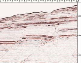
vic_bod04_mah_aw.qxd 6/04/04 12:56 PM Page 4
VICTORIAN SUPPLEMENT 2004
BASIN STUDIES GROUP UPDATE
REVIEW OF 2004 ACREAGE RELEASE BLOCKS
Complementing this renewed BY DR MIKE WOOLLANDS
industry activity in 2003, the (MANAGER BASIN STUDIES),
Commonwealth and State
governments gazetted for work
HYWEL THOMAS & DR TOM
program bidding four offshore BERNECKER (SENIOR PETROLEUM
Gippsland Basin blocks and GEOSCIENTISTS) AND JIM DRISCOLL
two State waters blocks. In (PETROLEUM GEOLOGIST)
2004, a further two
Dr Mike Woollands Hywel Thomas Dr Tom Bernecker Jim Driscoll
Commonwealth blocks are in Gippsland and, after a hiatus in offshore
being gazetted in the Otway Basin and the State exploration, Esso returned in 1982 to drill
T
he year 2003 was an active one for
hydrocarbon exploration in Victoria. of Victoria will release one State waters block in Triton-1 which was spudded a few hundred
Four new permits were awarded in the Otway Basin and three onshore blocks in metres from Nautilus-1. The well tested the
the Gippsland Basin and Esso discovered a the Murray Basin, Northern Victoria (Figure 1). Turonian Waarre Formation at 3400 mKB,
35 m gross gas column in the Golden Beach which was characterised by low poroperm
The 2004 gazettal blocks cover a diverse reservoir and high water saturation values.
Subgroup at Scallop-1. In the onshore, Lakes
range of play settings from sparsely explored Gas shows were recorded throughout the
Oil operated three wells culminating in their
acreage adjacent to the Otway Basin’s recent overlying Belfast Mudstone (Figure 3) and
Wombat-1 gas discovery on the Merriman
gas discoveries in the case of V04-1 to entire post-drill analysis suggests that the well may
anticline. This well flowed gas from tight
sub-basins in the case of V04-2. The blocks not have tested the crestal part of a valid
sandstones of Late Cretaceous age, thereby
on offer will be described in VIMP Report structural closure.
extending the Golden Beach Subgroup play
No. 83 currently in preparation and are
fairway onshore. In the Otway Basin, two V04-1 also lies adjacent to the La Bella Field
summarised below.
blocks within the State’s Three-Mile Zone in VIC/RL7. BHP Petroleum discovered gas in
were awarded and strong gas shows were the Flaxman and Waarre sandstones at La
encountered in Cretaceous sandstones in COMMONWEALTH OF AUSTRALIA Bella in 1993, however, the accumulation is
Melba-1, an onshore well operated by Santos. RELEASE AREAS currently uncommercial (210 Bcf GIIP). The
In addition to two other onshore wells drilled Geographe and Thylacine gas fields, both
by Santos and Origin, Santos also drilled Hill- Area V04-1 discovered by the Woodside Joint Venture, lie
1 in offshore permit VIC/P51. Located some Area V04-1 is located in the southeast of the less than 15 km from the eastern boundary of
50-65 km from the nearest wells, this well is offshore Otway Basin some 50-60 km the gazettal area.
expected to provide crucial geological southwest of Port Campbell. The block covers
information in an unexplored part of the More recently, in 2003, Santos drilled Hill-1 in
an area of approximately 1874 km2 straddling
basin. Another successful appraisal well in the adjoining permit VIC/P51, some 13 km from
the Tartwaup-Mussel Fault Zone and the
offshore Otway Basin, Casino-3, was drilled by the western boundary of V04-1. This well,
Voluta Trough (Figure 2). The majority of
Santos on the Casino gas field. As far as which reached TD at 2575 mKB, is believed to
V04-1 lies in water depths of 100-500 m,
seismic acquisition is concerned, 3D seismic have targeted sandstone intervals in the
locally exceeding 1000 m. Only two
surveys continued to be the preferred method Tertiary and Late Cretaceous Sherbrook Group
exploration wells have been drilled in the
with new surveys completed in the Gippsland and is likely to be followed by further drilling
area. Nautilus-1 was drilled in 1968 by
Basin (Tuskfish), offshore Otway (Antares) in 2004.
Esso/BHP to test a Oligocene structural/
and onshore Otway (Nelson). stratigraphic trap analogous to the Marlin field The Waarre Formation represents the primary
141°E 142°E 143°E 144°E 145°E 146°E 147°E 148°E 149°E
target on the marine shelf, but is downthrown
34°S Production Licences Gas Pipeline 34°S to depths in excess of 3000 m south of the
Retention Leases
Mildura
2003 EXPLORATION ACTIVITY Current Permits
Oil & Other Pipeline
Proposed Pipeline
Tartwaup-Mussel Fault Zone. As a result, this
VIC/M-04(1) 2003 Acreage Release
Closes March 2004
2003 Acreage Release
Gas Field interval is only regarded as a secondary target
Oil Field
Northern
Closed Sept. 2003
2004 Acreage Release
in V04-1. However, Late Cretaceous trap
Territory
Western
Australia South
Queensland
Marine National Park formation may have captured earlier generated
35°S Australia New South 35°S
Wales
Marine Sanctuary hydrocarbons within the Waarre sandstones
Victoria
Swan Hill Marine Special Management Area
Tasmania
Aquaculture Zone thereby preserving reservoir qualities.
VIC/M-04(2) A number of shallow plays have also been
Cobram
36°S Echuca
36°S
identified in the northwest of the gazettal
Wodonga
Chiltern 0 50 100
area, the principal play here being sandstones
MURRAY BASIN VIC/M-04(3) Shepparton Wangaratta
Kilometres
Benalla
in the Paaratte Formation that are sealed by
Eastern
Horsham Bendigo Euroa
Gas Pipeline
Duke Energy intraformational mudstones or by the K/T
SEA Gas
Origin Carisbrook Seymour
Bunga Creek -2
Boundary Shale overlying the Sherbrook
37°S Patties Pies -1 37°S
New Offshore
Group in tilted fault blocks (Figure 4).
Ararat Wombat -1
Koroit West -1 New Onshore
Permits Awarded
Additional plays include as yet untested outer
Ballarat
GIPPSLAND BASIN
Banganna -1
Hamilton
Melba -1 Melbourne
Permit Awarded
Orbost
shelf/slope sediments involving sandy facies
Nelson 2D/3D
106 km
2 OTWAY BASIN
Maffra
of the Pebble Point Formation that are sealed
Lara 223 km 2D
38°S
04
-1(v
Geelong Longford
Sale Seismic 38°S
200m
by the Pember Mudstone, or Oligocene
) New Permits
200m
Portland
Cobden
Awarded Scallop -1
1000m
lowstand fans. The potential of these shallow
1000m
2000m plays will become clearer, once the results
V04-2
2000m
V04-1 3000m
from Hill-1 are made available.
Tuskfish 3D
39°S Megamouth -1 1000 km
2
39°S
Area V04-1 contains all the required
3000m 4000m
Hill -1 Victoria
Casino -3 Tasmania
Appraisal Tasman 221 km 2D
4000m Antares 3D2
Yolla
Bass Gas
Natural Gas Pipeline
Duke Energy
Seismic petroleum systems elements, including
c. 200 km Origin
access to mature source rocks. Its
141°E 142°E 143°E 144°E 145°E 146°E 147°E 148°E 149°E 150°E
palaeogeographic location, covering inner to
outer shelf regions, provides the setting for a
Figure 1. 2003 Exploration Activity and Acreage Release Areas
4 PESA News April/May 2004
vic_bod04_mah_aw.qxd 6/04/04 12:56 PM Page 5
VICTORIAN SUPPLEMENT 2004
BASIN STUDIES GROUP UPDATE
142°E 142°30'E 143°E
Formation above the Eastern View Group
Port Campbell
(Figure 3) along the southern margin of the
Embayment
38°30'S
38°30'S
sub-basin. Although several sandy intervals
Champion 1 with excellent reservoir characteristics were
VIC/P51 intersected, no hydrocarbons were
Mussel encountered. The third well, Wild Dog-1, was
Platform
drilled in 1992 by Shell to test another
VIC/P44
P1
Pecten 1A
Minerva Boonah structure but also failed to
encounter hydrocarbons.
03
W3 VIC/
-1
L22
M
91
OH
us
The Torquay Sub-basin contains all the
s
O1
Hill 1
P2 el Casino
necessary ingredients for hydrocarbon
Shipwreck
Trough
Fa
ul Conan 1 VIC/P43 entrapment, therefore the failure of the three
t
wells has been attributed to the Miocene
V04-1 Zo
anticlines post dating expulsion and/or
VIC/RL7
migration processes. Furthermore, all three
Vo
La Bella
ne
Mussel 1
Triton 1 Nautilus 1
lut
exploration wells were focused on structural
39°S
39°S
a
0 20
VIC/P52 W1 features within the Tertiary portion of the
Tr
km Geographe Nth 1
W2 basin-fill, whereas the potential in the older
ou
Cretaceous section has yet to be adequately
gh
Geographe
Limit viable Belfast Waarre Fm. Leads
tested. Evidence for the presence of source
Mudstone seal
Victoria rocks within the Eumeralla Formation is
Good Paaratte intraformational Tasmania
Paaratte Fm. Leads
seal development
derived from the existence of several minor
Limit Timboon
Sandstone reservoir
Mepunga Fm. Leads 4000mss contour
Top Waarre Fm.
Thylacine
oil and gas shows that were detected in
Limit Paaratte reservoir
development
Oligocene Fan Leads
Anglesea-1, from seep detection work
142°E 142°30'E 143°E
conducted by GA (formerly AGSO) and the
Figure 2. Structural elements and leads in Area V04-1 existence of a seismic DHI (Figure 6) within
SW NE
variety of petroleum plays, ranging from Otway/Sorell speculative survey. V04-1
Lead P1
V04-1 Paaratte Sandstone Plays
fluvio-deltaic to shelf-break/slope fan Nevertheless, Area V04-1 offers a 0.0 0.0
scenarios. However, the area suffers from the variety of exploration targets. The
Top Wangerrip
poor quality of the older seismic data sets, recent gas discoveries in Group
which is in part caused by changing water adjacent acreage provide Top Sherbrook
Group
depths. Seismic surveys over the area are encouragement for future
exclusively 2D and vary in quality and extent. exploration programs, especially 1.0 1.0
The most recent data was acquired by Fugro with the outlook for Top Waarre
Formation
Seismic Australia Pty Ltd. as part of their 2001 development of the new TWT Transgressive Unit TWT
offshore fields.
(s) (s)
EPOCH AGE Stratigraphic Units Stratigraphic Units
Area V04-2
Otway Basin Torquay Sub-basin 2.0 2.0
SEAWARD LANDWARD SEAWARD LANDWARD Area V04-2 lies 100 km from
PLEISTOCENE Calabrian Newer Volcanics
PLIOCENE L
E
Piacenzian
Zanclean
Messinian Hanson Puebla
Melbourne and covers
L Port Plain Sand
Tortonian
10
MIOCENE M Serravallian
Campbell
Lst
Formation
approximately 4630 km2 of
TORQUAY
GROUP
Langhian
20 E
Burdigalian
Aquitanian
Gellibrand Marl
Jan Juc continental shelf over the 2km
Formation
offshore part of the Torquay
Clifton Areas of high reflectivity
L Chattian Fm
OLIGOCENE
30
Sub-basin. The area is bounded Figure 4.Seismic Line through Paaratte Leads in northwestern Area V04-1
E Rupelian
BLUFF GP.
DEMONS
Narrawaturk Angahook Fm.
L Priabonian Marl Demons
Anglesea Siltstone
Bluff
Boonah Fm.
by the Three-Mile Zone to the
Fm
40 Bartonian
Mepunga
EOCENE M Fm Eastern
Lutetian View Fm
northeast, the King Island-
50
E Ypresian
Dilwyn
Fm the Boonah sandstone in an anticline of
Eastern
Mornington High to the southeast (Figure 5),
EASTERN VIEW
Thanetian Pember
L Mudstone
Eastern
Oligocene age adjacent to the Nerita Deep.
GROUP
View Fm View
60 PALEOCENE Selandian
E Danian
Pebble
Point Fm
Cret / Tert
Group and extends as far as the Victoria/ Tasmania
Boundary
70 Maastrichtian Shale Member
Timboon
Sst
border in the southwest. Water depths are A number of leads have been identified
80 LATE
Campanian
Belfast
Paaratte
Formation shallow, with a maximum depth of approx- (Figure 5). These include untested Tertiary
Santonian
Coniacian
Mudstone
Nullawarre
Greensand
Flaxman Fm
imately 90 m. anticlines, some of which exhibit an earlier
90 Turonian
phase of structuring along the eastern flank
Cenomanian Waarre Formation
Three wells have been drilled in the block.
100 of the sub-basin. Other leads involve Pretty
Albian
The first well, Nerita-1 was drilled by Shell in
Eumeralla Eumeralla
Hill Formation sandstones and/or basal
GROUP
Formation Formation
110 Aptian 1967 targeting the Tertiary Boonah
Katnook Katnook
Formation and Eastern View Group Eumeralla Formation sandstones in tilted
CRAYFISH SUBGROUP
EARLY Barremian Sst Sst
120 Laira Fm Laira Fm
Hauterivian Pretty Hill Pretty Hill
reservoirs along a NE-SW trending anticline fault blocks. These may involve a
130 Formation Formation
Valanginian that was formed during the Miocene. The stratigraphic element, as such sandstones
140
Berriasian
well intersected minor gas shows and are known to either onlap onto the
OTWAY
Casterton Casterton
Tithonian Formation Formation
150 LATE
Kimmeridgian reached 2042 mKB after penetrating a Casterton Formation or onto Palaeozoic
Oxfordian 600 m thick section of the Cretaceous basement highs. The proposed deeper
160 MIDDLE Callovian
Eumeralla Formation. Lack of success was reservoir targets have not been penetrated
Depositional Regime
300 L shallow to open
marine limestones
shallow marine and
nearshore sandstones
attributed to the timing of trap formation, within the Torquay Sub-basin, however,
E
G
E
open marine fluviodeltaic and lower coastal believed to post-date the expulsion and comparisons with onshore seismic data
500 marls plain sandstones, mudstones
N
D prodeltaic sandstones fluvial volcanoclastics,
migration of hydrocarbons. Snail-1 was suggest these horizons are likely to be
and marine shales lithic arenites, mudstones, coal
drilled by Hematite Petroleum in 1972 to test present.
Figure 3.Stratigraphic Chart for the Otway Basin and Torquay closures mapped at the top of the Boonah
Sub-basin
PESA News April/May 2004 5
vic_bod04_mah_aw.qxd 6/04/04 12:57 PM Page 6
VICTORIAN SUPPLEMENT 2004
BASIN STUDIES GROUP UPDATE
143°30'E 143°45'E 144°E 144°15'E 144°30'E 144°45'E
regarded as too deeply buried to provide a
38°15'S
viable target. However, parts of the
0 20 38°15'S
Bridgewater-Normanby High in the western
HINDHAUGH CREEK 1
km IRREWARRA 1
INGLEBY 1 GEELONG FLOW OIL CO 1
part of 04-1(v) may be shallow enough for
STONEYFORD 1
NALANGIL 1 TORQUAY 5
adequate reservoir development. The
TORQUAY 1-4
TIRRENGOWA 1
TORQUAY 6,7 northern flank of the high also has the
ANGLESEA 1A
ANGLESEA 2 R1
potential for closures in Cretaceous and Early
Eastern Tertiary fault-bounded structures. Here, the
E4 Flank
38°30'S
principal plays are Tertiary sandstones of the
E3
E5 38°30'S
Pebble Point Formation and the Cretaceous
B5 E2
Timboon and Paaratte sandstones sealed in
tilted fault blocks and NW-SE trending horsts
p
Nerita Dee
Seeps NERITA 1 E6
B4 by Pember mudstones or intraformationally.
OLANGOLAH 1
B1 A seismic section through this area is shown
38°45'S
E7 B2 B3
Wilkinson Lead -08B E1
? in figure 8.
DHI OS88A
ce ?
38°45'S
Seismic data 04-1(v) is limited to the tails of
WILD DOG 1 T1
r ra
Sn Te offshore surveys and therefore detailed
ail mapping of the Cretaceous fault blocks
V04-2 SNAIL 1 which comprise the most common leads in
Mornington High the area will require additional seismic data
39°S
to facilitate ties between the offshore and
in
onshore geology and to delineate prospects.
Basin Marg
39°S
Legend
Wilkinson Lead
DHI
King Island High Otway Group State & National
Outcrop Parks Murray Basin Areas VIC/M-04(1), VIC/M-04(2)
Otway Group Marine National
Leads
Top Boonah
Parks
Marine Sanctuary and and VIC/M-04(3)
Tests Special Management
Areas
Top Boonah
Leads Seeps The Murray Basin is mainly known for its rich
143°30'E 143°45'E 144°E 144°15'E 144°30'E 144°45'E
mineral sands occurrences, however, some
Continued On Page 7
Figure 5. Structural elements and leads in Area V04-2
V04-2 Top Boonah DHI
WSW ENE
Wilkinson Lead
Seismic data is generally sparse, particularly commercial accumulations of 0.38 0.38
at the basin margins. Although data quality is hydrocarbons have yet been
fair to good along the Snail Terrace and discovered in the area,
Top Jan Juc
within the Tertiary section, data quality numerous oil and gas shows Formation
within the Otway Group is particularly poor have been recorded, the most Base Jan Juc
Formation
within the Nerita Deep, where thick coals significant being in Lindon-1 1.0 Top Boonah 1.0
within the overlying Eastern View Group which intersected a 3 m oil Formation Top Eastern
View Group
attenuate reflections from the deeper column in the Early Paleocene TWT
(s) Top Otway
Group
TWT
(s)
section. No new seismic has been shot since Pebble Point Formation.
1990. It is anticipated that 3D seismic
South of the Tartwaup-Mussel
acquisition and detailed source rock
Fault Zone, which underlies the
maturation studies can significantly reduce
northern flank of the Portland
the exploration risks in this relatively
Trough, the Eumeralla and
1km
unexplored basin. 1.78 1.78
overlying Waarre/Flaxman
Figure 6. Seismic Line through Wilkinson Lead and Flat spot in Torquay Sub-basin
formations are generally
STATE OF VICTORIA RELEASE AREA
141°E 141°30'E 142°E
WILSON 1
Otway Basin Area 04-1(v) Thickness (m) CAROLINE 1
3371 FAHLEY 1 1317
WANWIN 1
600
500 400 300
Nort
hern 0
Limit
10
Legend
Borehole names
0
0
3211
1
10
0
TD
500
1784
0
She km
130
PINE LODGE 1
250 1
1 200 1 0 0 rbroo
FAHLEY 2
00 1400
16 1 11
Boreholes with
PALPARA 4
800000
70
90000
k
0
13 1 20 6 00
Area 04-1(v) lies in shallow water within the 2149 ANNYA 2 TD>1200m
00
DRIK DRIK 1 Gro
0
500 1460 1300 00
5
1221 885 MYAMYN 2 up
38°S 750 PALPARA 1 GLENAULIN 2 722 ARDONACHIE 2 Petroleum well names
357 WANWIN 3 HENKE 1 1193 1023 TD 38°S
1000 PICKS 2 1852 1435
00
500
Three-Mile Zone administered by the State PICKS 1 GREENBANKS 17
4
Lake Condah High
00
1250 566 Marine national park/
1226
1400
1500 320 GLENELG 1 MACARTHUR 3
sanctuary/ special
management area
NELSON 1 2226 WARRAIN 7 COBBOBOONEE 4 764
of Victoria. The block, covering an area of 1750
468 1786 1915
LINDON 1 LINDON 2
1 300
2000
1 400
2250 3011 970
COBBOBOONEE 5
260 km2, is located over the north flank of
400
2571
1 00
1768
2
1400
KENTBRUCK 3
the Bridgewater-Normanby High at the A’ KENTBRUCK 4
1733
15
00
COBBOBOONEE 2 1 60 HEYWOOD 13
HEYWOOD 10
1642
HOMERTON 3
1578
HOMERTON 4
404 1837
0
1842 1669
westernmost Victorian part of the basin 04 NTH EUMERALLA 1
12
0
0
30 Possible Fault 17
00
NARRAWONG 16 2961
-1
1
1670
1
0
Bounded Leads
20
13 1
0
(v
0
30
0
adjacent to the South Australian border
0
EUMERALLA 1 PRETTY HILL 1
) GORAE 4 GORAE 2 3139 2478
00
18
14 2
00 18530 0 0 1630 NARRAWONG 15 WINDERMERE 1
00
1 0
0 NORMANBY 1 Portland
9
1904
(Figure 7). No wells have been drilled in the
1
TYRENDARRA 13 1852
MOUZIE 1
4
0
3308
80
700
13 0
0
Trough 1948 MIRAMS 1 1406 WINDERMERE 2 SHAW 1
GORAE 5 383 3595 CODRINGTON 1 960
13
Normanby 0
1799 NARRAWONG 13
0
1265
block, however, four offshore and numerous
1400
1713
90
14 0 0
High
0
15
0 0
00
onshore petroleum and water wells have
23 0
14
PORTLAND NTH 1
0
15
A TREWALLA 5 864
00
00
15 10
00
1659
22
00
PORTLAND 3 PORTLAND 2
16 0 0
YAMBUK 2
been drilled nearby. Of these only Glenelg-1 16
0 TARRAGAL 3
1718
PORTLAND 14
1438
PORTLAND
23 00 1
1537
0
1728 1420 690 BELFAST 11
11
12 1483
PORTLAND 11
00
13 0
00 2
reached the base of the Tertiary and many of PORTLAND 83 00 00
12
13 0
1242
13 0
0
1383
0
PORTLAND 13220 0
0
1500 PORTLAND 12 1241
DISCOVERY BAY 1 608 PORTLAND 10
00
2 1 00 21
110 0
the petroleum wells were drilled on the 2776 VOLUTA 1
3974
1595
22 17 00
22
13
0
600
0 0
0
70
0
00
1
180
0 1
140
basis of poor quality or non-existent seismic
0
0 140
0
14 0
0
0 50 0
1
21090
data. Offshore, until the recent Essential
190 0
0
38°30'S Cape 0 130
0
15
00
0
38°30'S
14
Bridgewater
00
14 00
0
Petroleum VIC/P46 survey, the pre-existing
6
1
0
5
Lead
1
BRIDGEWATER1 BAY 1
2002300 4200 400 90
1
2 00
140 0
1
2 0 00
50 0 00 18 17
0
21
Phillips OP80 survey provided only a coarse
1 0 0
2
0
00
0
24
16
00
2 km x 5 km grid of seismic data on which
141°E 141°30'E 142°E
Normanby-1, Bridgewater Bay-1 and Figure 7.Depth structure map for top-Sherbrook Group horizon in Area 04-1(v)
Discovery Bay-1 were based. Although no
6 PESA News April/May 2004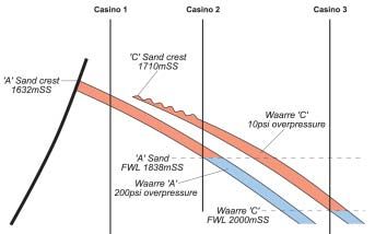
vic_bod04_mah_aw.qxd 6/04/04 12:57 PM Page 7
VICTORIAN SUPPLEMENT 2004
EXPLORATION ACTIVITIES
THE SOUTHERN MARGINS OF AUSTRALIA - ROOM FOR GROWTH
BY SANTOS LIMITED
antos has established itself as Otway/Sorell Basins gazettal blocks
S a leading player in the
Southern Margins with
exploration and production in both
in September 2002 followed by two
additional blocks in 2003. The total
program could see exploration
the Gippsland and Otway basins. expenditures of up to $216 million
The Company’s most significant over the next six years in one of the
recent activities on the Southern most attractive frontier trends in the
Margin are the Casino success story Australian offshore (Figure 1).
and its drive into the deep water
Santos is Operator of all six new
frontier Otway Basin trend.
permits with equity interest ranging
Santos has also continued to grow from a third to 80 percent. The
its position in the Gippsland Basin permits, five of which are in deep
with the award of VIC/P55 in August water, cover a total area of 26,173
of 2003. square kilometres, with prospects in
water depths up to 1,500 metres.
Building on the success of its
This play trend had not been
onshore operations, Santos has
previously tested, but the prospects
carried its technical knowledge and
identified are encouraging. Some
market position into a successful
3,533 km of 2D and 792 km2 of 3D
wildcat and appraisal program at
seismic data has been acquired in
Casino. In addition, Santos has
2002 and 2003 and the first of three
extended its activities into the
second permit year wells (Hill-1) has
frontiers - both within its Victoria
now been drilled and is currently
base and into the neighbouring
being evaluated.
states of Tasmania and South
Australia. The seismic programs in the recently
awarded permits presented specific
AUSTRALIAN FRONTIERS - challenges to ensure high quality
data was acquired during the least
DEEP WATER OTWAY environmentally sensitive months
A consortium led by Santos Limited which coincided with calm seas.
was awarded four of the 2001 Acquisition therefore had to be
Figure 1. Santos’ current South Australian/Victorian/Tasmanian Southern Margins acreage
position
Continued From Page 6
Pageuntapped hydrocarbon potential may SW NE
A A’
exist within Palaeozoic or Permo-Triassic VIC/P46 04-1(v)
infra-basins that unconformably underly the NORMANBY-1
Tertiary basin-fill. Three blocks in the Murray 0.0 0.0
Basin have been gazetted, one in the Top Nirranda
Group
Victorian part of the Wentworth Trough
(VIC/M-04(1)) and two near and in the
Numurkah Basin (VIC/M-04(2) and VIC/M-
04(3)). Some geological knowledge in terms TWT Top Wangerrip TWT
(s) Group Top Pember (s)
of stratigraphy and structuring is available Mudstone
from limited well control and some seismic
surveys. The most important issue in the
areas remains the identification of mature 1.0 1.0
source rocks that are present at depth
Top Timboon
associated with the Palaeozoic strata. Sandstone
Top Belfast
Mudstone
FURTHER INFORMATION
The Basin Studies Group has published
summary reports on all 2004 gazettal blocks Top Waarre
Formation
which are available on one CD-ROM (VIMP
83). These reports give overviews on the 2.0 2.0
hydrocarbon prospectivity of the gazetted 2km
areas and include listings of available data-
sets. The CD-ROM and data sets can be
obtained by contacting the Petroleum Client Figure 8.Seismic Line through 04-1(v) across northern flank of Bridgewater-Normanby High
Services at GeoScience Victoria, Department
of Primary Industries. ◆
PESA News April/May 2004 7vic_bod04_mah_aw.qxd 6/04/04 12:57 PM Page 8
VICTORIAN SUPPLEMENT 2004
EXPLORATION ACTIVITIES
achieved in a short timeframe The value of the 3D technique
with first acquisition achieved 85 was born out by results of
days from the permit being exploration and appraisal
awarded. This could not have programs onshore and carried
been achieved without close into the offshore environment.
and open discussions with both
Casino-1 and Casino-2 were
the Designated Authorities and
drilled in 2002 followed by
relevant stakeholders.
Casino-3 in 2003 (Fig. 4). The
Ongoing research into the first two wells demonstrated the
impact of seismic and drilling existence of two separate gas
activities on cetaceans and charged reservoirs supporting
fisheries is being carried out as the attributes mapping on the
part of the field operations and 3D seismic data (Fig. 3) set but
in collaboration with local creating two serious challenges
universities and the regulatory to quantifying the reserve
agencies. This activity creates an potential of the field. The critical
excellent opportunity for issues to be resolved by the third
environmental and research well related to the distribution
agencies to work with the and preservation of the Waarre
petroleum industry to capture reservoirs west of the Shipwreck
significant volumes of data to Figure 2. A series of significant prospects in the deep water trend have been defined by high quality trough and the integrity of the
seismic data
advance our knowledge and intra Waarre seal encountered in
better understand the both Casino-1 and Casino-2.
sustainability of the ecosystem in
The results of Casino-3 (Fig. 4)
which we operate.
are currently being incorporated
These new permits represent a into a field development model
significant opportunity for Santos with the intention of reaching a
and reinforce the key role that field development decision
exploration plays in the midyear 2004.
Company’s growth strategy. The
Santos Limited is a major
prospects within these frontier
Australian oil and gas
permits are high-risk but have
exploration and production
high-impact exploration potential
company with interests in all
for both oil and gas. Santos has
Australian hydrocarbon
world-class joint venture
provinces. The Santos Group
participants and the acreage is
also operates in the USA,
close to existing areas in which
Indonesia and PNG.
the Company operates. This
program, the Company’s first in For further details contact Thom
deep water, is part of the Figure 3. The attributes map on the Waarre sand horizon show an excellent correlation of the gas water Jewell at Santos. ◆
strategic broadening of Santos’ contact in both the Waarre A and C sands
interests.
CASINO
Experience with the onshore Otway
evaluation program and studies of historical
analogues confirmed that the coincidence
of full stack seismic amplitude anomalies
and Amplitude Variations with Offset (AVO)
response, within structural closure reduced
the exploration risk for the Waarre
Sandstone Play and therefore was a key
driver for the Casino and onshore Otway
drill programs.
The application of 3D seismic technology
and the utilisation of “high-end”
geophysical techniques were important
factors in the exploration and appraisal
successes in 2002 and 2003. Traditional 2D
seismic techniques were used to effectively
“screen” the large permits leading to the
acquisition of high density 3D seismic Figure 4. The schematic cross section demonstrates the results of the three well program that has confirmed the down flank
coverage over the most prospective areas. distribution of the Waarre C reservoir and more importantly the pressure separation of the two reservoirs.
8 PESA News April/May 2004vic_bod04_mah_aw.qxd 6/04/04 12:57 PM Page 9
VICTORIAN SUPPLEMENT 2004
EXPLORATION ACTIVITIES
BASS STRAIT OIL COMPANY LTD - UPDATE ON ACTIVITIES, OFFSHORE
GIPPSLAND BASIN
B
ass Strait Oil Company Ltd (BSOC) VIC/P42 147°00' 148°00' 149°00'
is exploring in three permits in the The 3D seismic data acquired in
Orbost Drilling in
preparation
Bairnsdale
offshore Gippsland Basin; Vic/P41 - 2002, and processed and loaded Lakes Entrance
Vic/P47
75% and operator, in joint venture with in 2003, has now been interpreted 38°00' Baleen
Sunfish Patricia
partner Eagle Bay Resources NL (EBR), to resolve the depth conversion Oil & Sale
Wirrah
Sweetlips
Moonfish
North
Turrum West Kipper Sole
Gas Pipelin Tuna
es
Vic/P42 - 50% and operator with partner issues beneath the high velocity
Seahorse
Snapper
Turrum
Tuna
Manta
Vic/P41
Whiting Marlin Batfish
Inpex Alpha (50%) and Vic/P47 - 75% Miocene submarine canyon
Whiptail
Mulloway
Barracouta
Flounder Basker
Tarwhine Halibut
and operator with partner EBR. sequences. Image-ray depth Dolphin Bream
Fortescue
Yellowtail
Cobia
Mackeral
Bream 'B"
Blackback
2003 was spent evaluating an extensive conversion of the pre-stack time Perch Omeo
Gudgeon
Kingfish 3D acquisition
in preparation
database of new 3D and 2D seismic migrated 3D data was undertaken
Vic/P42 Archer Anemone
acquired by BSOC in these permits through using a dense seismic velocity Drilling in
2002 and early 2003, together with the ’cube’ extracted during processing. preparation
39°00'
’maturing’ database of existing surveys. This has identified a number of 0 20 40
BSOC Interest
BSOC now has a portfolio of drillable significant depth prospects and Kilometres
prospects defined on high quality 3D reduced the depth conversion risk
Figure 1. location map of Vic/P41, Vic/P42 & Vic/P47
seismic. With Perth based drilling project that previously existed. An
managers’, Labrador Petro-Management, inventory has been compiled
148o45’E 149o00’E 149o15’E
preparations have been made for the and preparations made for
Oil Field
drilling of a well in each of Vic/P42 and drilling the highest ranked Gas Field
Vic/P47 in 2004. In Vic/P41 3D seismic is to prospect in 2004. Top Latrobe closure
Intra-Latrobe closure
Northright-1
N
be acquired to improve definition and risk Golden Beach closure
assessment of a portfolio of leads and VIC/P47 o
38 00’S
prospects already identified on 2D data.
BSOC has obtained over 424 Wahoo-1
km2 of 3D seismic acquired
VIC/P41 during the period 1999 to 2002, Leatherjacket-1
The 222 km 2D survey acquired by BSOC in in and around Vic/P47. This Sole-2
Sole-1
early 2003 resulted in a more provides a high coverage of the Dart-1
JUNGER
comprehensive seismic coverage of the more prospective southern part Hammerhead-1
WILDE
permit. Interpretation of the new and pre- of the permit. The interpretation Rosedale Fault Trend
existing survey data has produced an has identified the highly KIPLING BENCHLEY
extensive portfolio of prospects and leads significant Moby Prospect, COTTON
approximately 5 km east of the
o
38 15’S
in Vic/P41 (see figure 2). The complete Chimaera-1
Manta-1
OSCAR
Shark-1
database has now been interpreted. As a Patricia gas field. The prospect
Gummy-1
result BSOC has exercised its option to has strong amplitude anomalies Basker-1
Basker South-1 SCORPION
increase its interest to 75% by committing at the top Gurnard Formation
to acquire the 250 km2 3D seismic survey. level, similar to those over the
Moby Oil and Gas Ltd has been granted an Patricia and Baleen gas fields Whaleshark-1
option to earn 30% (of BSOC interest) by (see figure 3).
contributing to the costs of this 3D survey. Moby also has the potential for
The most significant of the identified an oil leg, as the structure 0 2 4 6 8 10
Vic/P41
Kilometres
prospects and leads are on trend with (and appears (from amplitude data) 38o30’S
o
148 45’E
o
149 00’E
o
149 15’E
analogous to) the Kipper Field. Current to be underfilled by gas. BSOC
planning is to acquire the 3D programme holds a 75% interest in this Identified Leads in Vic/P41
over the play fairway identified southwards permit and has executed a
of the Rosedale Fault Trend. farmout agreement with Moby Figure 2. prospects and leads in Vic/P41
Oil and Gas Ltd whereby Moby
will contribute to the drilling of the Moby-1
Baleen Gas Field exploration well and thereby earn 35%
interest from BSOC’s 75%. Preparations
have been made to drill the well in 2004.
THE FUTURE IN 2004
BSOC has developed a database over a large
portion of the Gippsland Basin. Expertise
acquired from operatorship of the numerous
permits and a ’new’ perspective on some of
the old problems besetting this maturing
province has allowed the company to
Moby Prospect identify several new opportunities that are
Patricia Gas Field being pursued. ◆
Figure 3. Amplitude extraction at top Gurnard Formation (gas bearing reservoir) over Patricia, Baleen and Moby
PESA News April/May 2004 9vic_bod04_mah_aw.qxd 6/04/04 12:58 PM Page 10
VICTORIAN SUPPLEMENT 2004
FIELDS AND INFRASTRUCTURE DEVELOPMENT
BY DAVID WONG1 &
THE CHANGING FACE OF THE VICTORIAN GAS INDUSTRY TERRY MCKINLEY2
M
ajor gas infrastructure • The BassGas Project - Construction of the
developments continue to plant commenced in 2003 and is
expand in Victoria. The expected to be completed by mid 2004.
completion of the SEA Gas pipeline The onshore pipeline is currently being
project in 2003 marked a significant constructed and is expected to be
milestone for the gas industry in southeast completed by the end of April 2004.
Australia. This pipeline became a vital Construction of the shore crossing
supply link to South Australia during the pipeline and offshore pipeline were
Moomba Gas Plant fire early this year. completed late last year. Installation of
With this link in operation, interconnected the offshore platform and wells is on David Wong Terry McKinley
high pressure gas pipelines now link SE schedule for completion by mid-year.
Australia (Victoria, New South Wales, First gas is expected in the second half
Tasmania and South Australia), thus, of this year.
opening this fast growing region to both
Other project developments (see Map on
existing and new market players. Access to
inside back cover) that will continue
pipeline infrastructure will facilitate
beyond 2004 include:
development of more remote fields,
enlarging the domestic and commercial • The Otway Gas Project (Geographe-
energy market and the choice of retailers to Thylacine Fields - Offshore Otway
sell to. Greater exploration efforts as shown Basin) that has undergone EES/EIS
by recent awards of exploration permits in process with public hearings
the Otway and Gippsland basins reflect the completed in November 2003. First
rate of expansion of the industry during the gas delivery is expected in 2006.
past 12-18 months. Energy demand in SE • The Sole Gas Project (Offshore
Figure 2. Cliff face at Two Mile Bay; BHP Billiton Minerva gas pipeline
Australia has grown significantly and the Gippsland Basin) - the project has
crossed this shore by HDD from north of the Great Ocean Road
trend is expected to continue over the next undergone EES process with public
decade. The challenge is to find new gas hearings also completed in November
supplies and maintaining the security of 2003. environmental outcome when
energy supplies while reducing impact on • The Turrum oil development project constructing pipelines through sensitive
(Offshore Gippsland Basin) - Esso/BHP coastal areas. By drilling under the coast
Billiton has commenced further there is virtually no impact on coastal
development drilling of the Turrum oil flora and fauna. Recent examples of HDD
field. construction are the Minerva pipeline
• The Santos Casino gas field project in the crossing under the Port Campbell
Offshore Otway Basin, while other National Park (Figure 2) and the BassGas
possibilities are the Golden Beach and pipeline crossing at Kilcunda under
Kipper gas fields in the offshore sensitive vegetation and coastal sand
Gippsland Basin. dunes. BHP Billiton, for its Minerva
project, was able to successfully
complete a 1600 m hole for a
CHANGE FACTORS AND PROCESSES 250 mm pipe. In both cases the HDD
Recent changes in exploration technology drilling rig was set up in adjacent
and infrastructure development processes pastures away from the sensitive coastal
have created a whole set of new outlooks for area (Figure 3). Rehabilitation of the sites
the gas industry in Victoria. Among these is carried out after removal of the drilling
are: equipment to ensure that the site is
• 3D Seismic data that has become more restored to its original state. In deciding
Figure 1. Testing at Minerva-3, offshore Otway near Port Campbell commonly used in recent years and has that the Santos Casino project would not
(photo courtesy of BHP Billiton) proved to be an effective tool in new gas be required to prepare Environment
discoveries. Santos in its onshore Otway Effects Statement, the Minister for
exploration scored almost 100% success Planning took into account that the
the environment and ensuring the economic company had committed to drill from
in its exploration drilling campaign. The
well being of the community. private land beyond the sensitive coastal
Casino, Geographe and Thylacine fields
were discovered by drilling exploratory fringe. This has the potential to save the
INFRASTRUCTURE DEVELOPMENT wells based on maps project months in its approvals process.
ACTIVITIES delineated using 3D seismic
Recent construction has taken place on the data and associated with
following development projects (see Map on seismic characteristics that
inside back cover): reduced the exploration risk
significantly.
• The Minerva Gas Project - Offshore Otway
Basin. BHP Billiton completed all • Horizontal Directional
offshore construction including drilling Drilling (HDD) has been
(Figure 1) and laying of the pipeline in used in all of the shore
2003. The gas plant is currently being crossings for constructing
constructed with first gas expected late gas pipelines in the past 3
2004. years. The HDD technology
provides a much better Figure 3. BassGas HDD Thrust Rig site near Kilcunda
10 PESA News April/May 2004You can also read