VEGETATION ASSESSMENT: Proposed sewer line at Robberg Nature Reserve, Plettenberg Bay, Western Cape Province - HilLand Environmental
←
→
Page content transcription
If your browser does not render page correctly, please read the page content below
VEGETATION ASSESSMENT:
            Proposed sewer line at Robberg Nature Reserve,
                   Plettenberg Bay, Western Cape Province

PREPARED BY:                      PREPARED FOR:
Dr David Hoare                    HilLand Environmental cc
Postnet Suite #116                166 Mountview Farm,
Private Bag X025                  Victoria Heights
Lynnwood Ridge, 0040              P.O.Box 590
tel: (087) 701 7629               George, 6530
fax: 086 550 2053                 Tel: (044) 889 0229
e-mail: dhoare@lantic.net         Fax: (086) 542 5248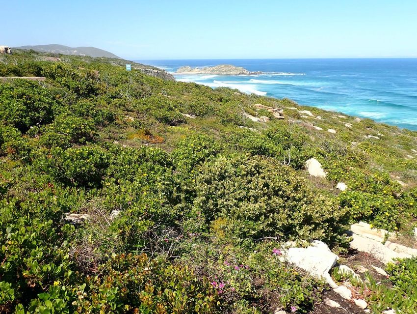
Vegetation and Flora of a part of Robberg Nature Reserve, Plettenberg Bay,
                                                                                                 1
 Knysna District, Western Cape

Declaration of Independence & Summary of
Expertise

Appointment of specialist
David Hoare of David Hoare Consulting (Pty) Ltd was commissioned by HilLand Environmental CC
to provide specialist consulting services for the Impact Assessment of parts of Robberg Nature
Reserve near Plettenberg Bay in the Knysna District, Western Cape Province. The consulting
services comprise an assessment of potential impacts on the flora and vegetation in the study
area due to proposed pipeline.

Contact details
Dr David Hoare
David Hoare Consulting (Pty) Ltd
Postnet Suite no. 116
Private Bag X025
Lynnwood Ridge, 0040

Telephone: 087 701 7629
Cell:      083 284 5111
Fax:       086 550 2053
Email:     dhoare@lantic.net

Summary of expertise
Dr David Hoare:
   •   Dr Hoare has majors in Botany and Zoology with distinction from Rhodes University,
       Grahamstown, an Honours Degree (with distinction) in Botany from Rhodes University,
       an MSc (cum laude) from the Department of Plant Science, University of Pretoria, and a
       PhD in Botany from the Nelson Mandela Metropolitan University, Port Elizabeth with a
       focus on grassland diversity.
   •   Registered professional member of The South African Council for Natural Scientific
       Professions (Ecological Science, Botanical Science), registration number 400221/05.
   •   Founded David Hoare Consulting (Pty) Ltd, an independent consultancy, in 2001.
   •   Ecological consultant since 1995, with working experience in Gauteng, Mpumalanga,
       Limpopo, North West, Eastern Cape, Western Cape, Northern Cape and Free State
       Provinces, Tanzania, Kenya, Mozambique, Zimbabwe, Botswana and Swaziland.
   •   Conducted, or co-conducted, over 500 specialist ecological surveys as an ecological
       consultant. Areas of specialization include general ecology, biodiversity assessments,

  2 February 2021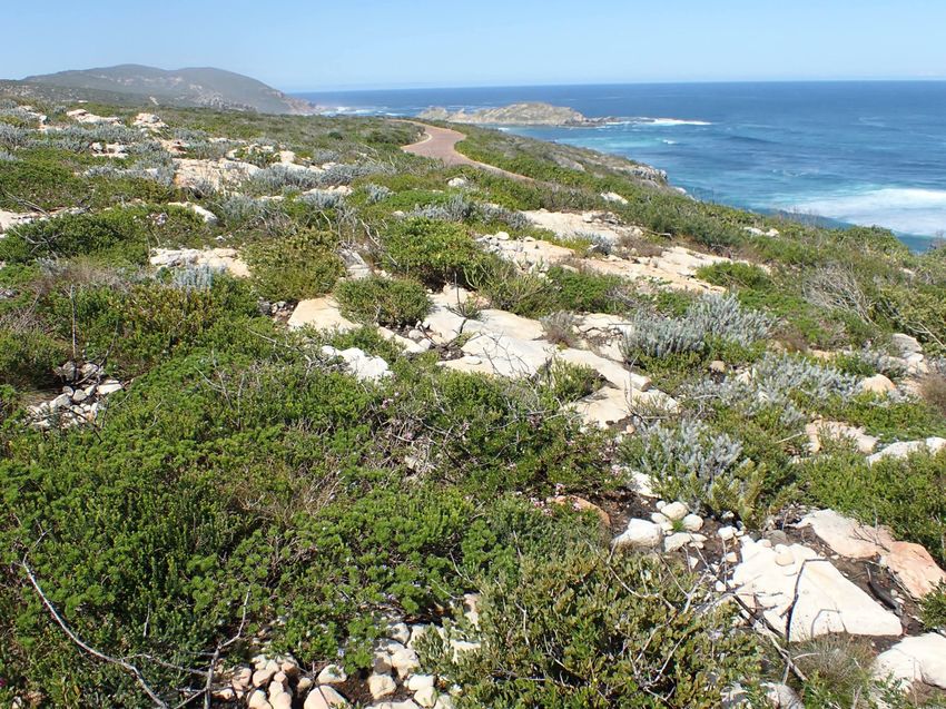
Vegetation and Flora of a part of Robberg Nature Reserve, Plettenberg Bay,
                                                                                                      2
 Knysna District, Western Cape

        vegetation description and mapping, plant species surveys and remote sensing of
        vegetation. Has undertaken work in grassland, thicket, forest, savannah, fynbos, coastal
        vegetation, wetlands and Nama-Karoo vegetation.
    •   Published six technical scientific reports, 15 scientific conference presentations, seven
        book chapters and eight refereed scientific papers.
    •   Attended 15 national and international congresses & 5 expert workshops, lectured
        vegetation science / ecology at 2 universities and referee for 2 international journals.

Independence
David Hoare Consulting (Pty) Ltd and its Directors have no connection with the proponent. David
Hoare Consulting (Pty) Ltd is not a subsidiary, legally or financially, of the proponent.
Remuneration for services by the proponent in relation to this project is not linked to approval by
decision-making authorities responsible for authorising this proposed project and the consultancy
has no interest in secondary or downstream developments as a result of the authorisation of this
project. David Hoare Consulting (Pty) Ltd is an independent consultant to the Environmental
Assessment Practitioner and has no business, financial, personal or other interest in the activity,
application or appeal in respect of which he was appointed other than fair remuneration for work
performed in connection with the activity, application or appeal. There are no circumstances that
compromise the objectivity of this specialist performing such work.

Indemnity and conditions relating to this report
The findings, results, observations, conclusions and recommendations given in this report are
based on the author’s best scientific and professional knowledge as well as available information.
David Hoare Consulting cc and its staff reserve the right to modify aspects of the report including
the recommendations if and when new information may become available from ongoing research
or further work in this field, or pertaining to this investigation.
This report must not be altered or added to without the prior written consent of the author. This
also refers to electronic copies of this report which are supplied for the purposes of inclusion as
part of other reports, including main reports. Similarly, any recommendations, statements or
conclusions drawn from or based on this report must make reference to this report. If these form
part of a main report relating to this investigation or report, this report must be included in its
entirety as an appendix or separate section to the main report.

  2 February 2021
Vegetation and Flora of a part of Robberg Nature Reserve, Plettenberg Bay,
                                                                                                                                                                      3
  Knysna District, Western Cape

Contents
Declaration of Independence & Summary of Expertise ........................................................................... 1
   Appointment of specialist ........................................................................................................................... 1
   Contact details ............................................................................................................................................ 1
   Summary of expertise ................................................................................................................................. 1
   Independence ............................................................................................................................................. 2
   Indemnity and conditions relating to this report ........................................................................................ 2

Introduction ........................................................................................................................................... 5
   Terms of reference and approach ............................................................................................................... 5

Desktop description of study area........................................................................................................... 7
   Study area ................................................................................................................................................... 7
      Location .................................................................................................................................................. 7
   Regional vegetation patterns in relation to the site ................................................................................... 9
     Goukamma Dune Thicket ....................................................................................................................... 9
     Proteoid Quartz Grassy Fynbos ............................................................................................................ 10

   Vegetation conservation status ................................................................................................................ 11
     National status ..................................................................................................................................... 11
     Provincial C-Plan status ........................................................................................................................ 12
   Plant species of concern ........................................................................................................................... 13

Methodology ........................................................................................................................................ 17

Results of the field survey ..................................................................................................................... 18
   Sensitivity assessment .............................................................................................................................. 21

Discussion ............................................................................................................................................. 22

Conclusion ............................................................................................................................................ 23

Recommendations ................................................................................................................................ 24

References ............................................................................................................................................ 25

Appendix 1: Red / Orange List plant species recorded within the geographical area within which the
study area is situated. ........................................................................................................................... 27

   2 February 2021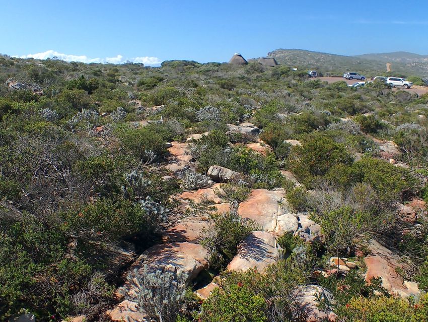
Vegetation and Flora of a part of Robberg Nature Reserve, Plettenberg Bay,
                                                                                                                                        4
  Knysna District, Western Cape

Appendix 2: Checklist of plant species found on site ............................................................................. 31

   2 February 2021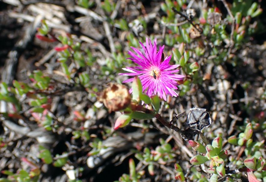
Vegetation and Flora of a part of Robberg Nature Reserve, Plettenberg Bay,
                                                                                                      5
 Knysna District, Western Cape

Introduction
This document presents the results of the flora and vegetation assessment of the study site, based
on a desktop and field assessment, as well as mapping from aerial imagery.
On 7 July 2020 David Hoare Consulting (Pty) Ltd was appointed by HiLand Environmental CC to
undertake an assessment of the flora and vegetation of the site within specific areas that have
been proposed for the upgraded sewer line.
The requirement of the study was to assess the sensitivity of the vegetation of the site and to
assess the possibility of any threatened plant species occurring there.

Terms of reference and approach
The fundamental requirement for this study is the compilation of a site screening / sensitivity
report which adheres to the following:

    •   The Initial Site Sensitivity Verification reporting requirements for environmental themes
        in terms of section 24(5)(a) and (h) of the National Environmental Management Act, 1998
        (Act No. 107 of 1998) (NEMA).
    •   Identification of any discrepancies with the environmental sensitivity as identified on the
        national web based environmental screening tool.
    •   Identification of the sensitive areas to be avoided (including corresponding spatial data)
        for each site.

The intention of the study was to provide an assessment of potentially sensitive vegetation or
plant species features on site that may be negatively impacted by development of the site. The
study was to include a site visit to assess the habitat on site with the view of making judgements
on:
    1. the condition of the vegetation on site;
    2. the sensitivity and conservation value of vegetation on site;
    3. the suitability of habitat for threatened plant species.

The study was to cover the remaining areas of natural vegetation on the site. The following
information was to be provided in the report:

    •   To provide a description of the broad vegetation types and/or habitats for the area,
        including any areas of potential conservation value. This will be based on published
        sources, including the vegetation map of South Africa (Mucina et al. 2006), the National

  2 February 2021
Vegetation and Flora of a part of Robberg Nature Reserve, Plettenberg Bay,
                                                                                                      6
Knysna District, Western Cape

      Spatial Biodiversity Assessment and any Biodiversity Conservation Plans that exist for
      Gauteng Province.
  •   To provide the national conservation status of major vegetation types in which the study
      sites are located, as listed in The National List of Ecosystems that are Threatened and
      need of protection (GN1002 of 2011), published under the National Environmental
      Management: Biodiversity Act (Act No. 10, 2004).
  •   To provide an assessment of the Red and Orange List (threatened, near threatened and
      declining) flora species that could occur in the project study area, including information
      on habitats in which they are most likely to be encountered.
  •   To investigate the potential presence of trees protected according to the National Forests
      Act and flora protected under the National Environmental Management: Biodiversity Act.
  •   To provide a list of the declared weeds or alien invader species on site, according to the
      Alien and Invasive Species (AIS) Regulations, in terms of Section 97(1) of NEM:BA,
      published in Government Notice R598 in Government Gazette 37885 in 2014 (NEM:BA,
      2014). The Alien and Invasive Species (AIS) lists, published in Government Notice R 864 of
      29 July 2016 (NEM:BA, 2016), lists declared weeds and invaders in one of the following
      categories:
          o Category 1a: Invasive species requiring compulsory control. Any specimens of
               Category 1a listed species need, by law, to be eradicated from the environment.
               No permits will be issued.
          o Category 1b: Invasive species requiring compulsory control as part of an invasive
               species control programme. Remove and destroy. These plants are deemed to
               have such a high invasive potential that infestations can qualify to be placed
               under a government sponsored invasive species management programme. No
               permits will be issued.
          o Category 2: Invasive species regulated by area. A demarcation permit is required
               to import, possess, grow, breed, move, sell, buy or accept as a gift any plants
               listed as Category 2 plants. No permits will be issued for Cat 2 plants to exist in
               riparian zones.
          o Category 3: Invasive species regulated by activity. An individual plant permit is
               required to undertake any of the following restricted activities (import, possess,
               grow, breed, move, sell, buy or accept as a gift) involving a Category 3 species. No
               permits will be issued for Cat 3 plants to exist in riparian zones.
  •   To compile an assessment and preliminary map of the general status of vegetation on site
      in order to provide a description of which areas contain natural habitat versus those that
      are transformed and/or degraded.

2 February 2021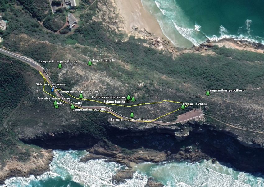
Vegetation and Flora of a part of Robberg Nature Reserve, Plettenberg Bay,
7
Knysna District, Western Cape
Desktop description of study area
This section provides a description of the location of the study area as well as an outline of the
background biodiversity information known for the study area.
Study area
Location
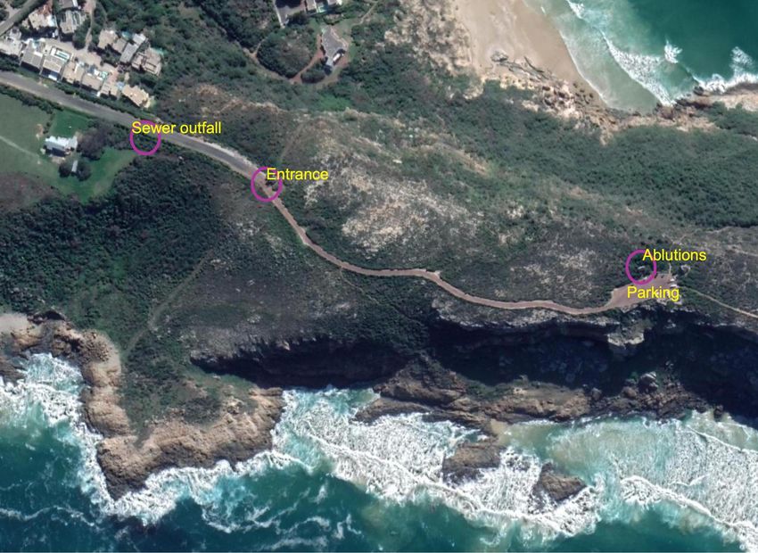
The site is located within the Robberg Nature Reserve in Plettenburg Bay (Figure 1). The proposed
new sewer line will connect the existing ablution facilities next to the parking area to a sewer
outfall just to the north of the main entrance of the reserve (Figure 2). There is an existing road
running in this general direction, connecting the parking lot to the main entrance (Figure 2). This
road, along with the visitor's parking area, the existing ablutions, and the buildings and levelled
Figure 1: Location of the site.
2 February 2021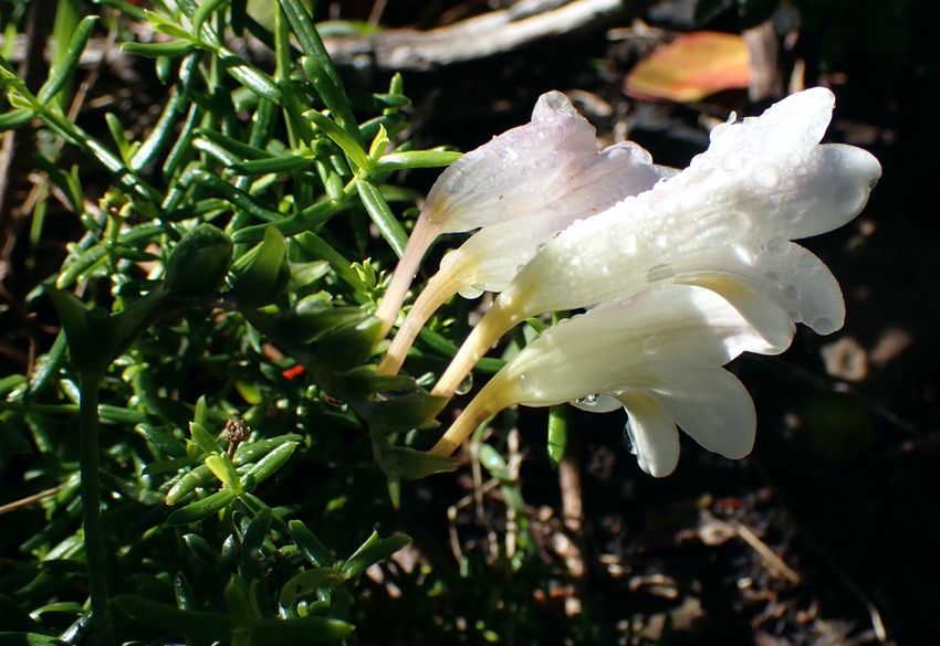
Vegetation and Flora of a part of Robberg Nature Reserve, Plettenberg Bay,
                                                                                                         8
 Knysna District, Western Cape

areas at the main entrance, represent the main existing disturbance on site. Other minor
disturbances include footpaths and two small lay-byes on the side of the road about 50 m south-
east of the main entrance. The remaining areas within the area of interest are all in a natural state.

 Figure 2: Aerial image of the site and surrounding areas dated 15 October 2019.

  2 February 2021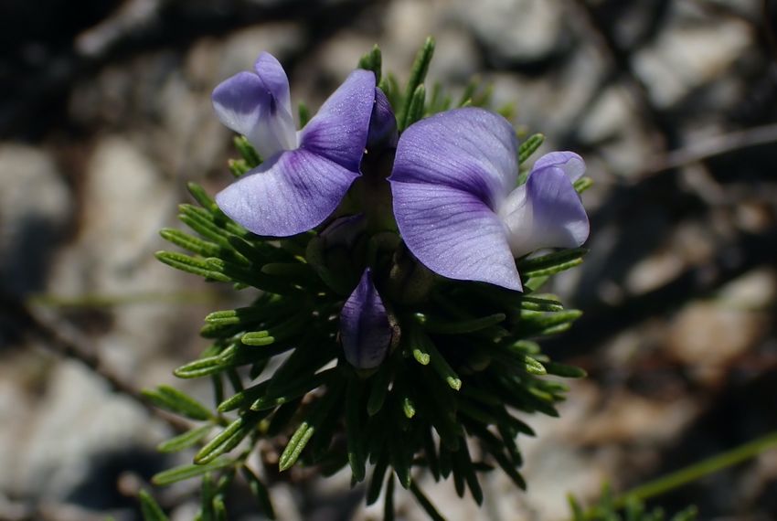
Vegetation and Flora of a part of Robberg Nature Reserve, Plettenberg Bay,
                                                                                                     9
 Knysna District, Western Cape

Regional vegetation patterns in relation to the site
A description of the regional vegetation type is provided here, because it provides an expectation
of the vegetation composition for any indigenous vegetation that occurs on site.
According to the most recent vegetation map of the country (SANBI, 2018) the study area falls
within one regional vegetation type, namely Goukamma Dune Thicket. There is one other
vegetation type mapped as being within close proximity to the site, namely Cape Seashore
Vegetation, but this is not affected by the current assessment. Any remaining natural vegetation
on site would therefore fall within Garden Route Shale Fynbos. The vegetation was previously
classed as Garden Route Shale Fynbos (VegMap 2006) but a recent update of the National
vegetation map has integrated thicket units into the national vegetation map leading to local
hanges in the published description of vegetation types (Grobler et al. 2018).

Goukamma Dune Thicket
Distribution: The vegetation type is found in the Western Cape Provinces in coastal stretches from
Victoria Bay near Wilderness to the Knysna Heads, with smaller areas along the coast from
Robberg Peninsula near Plettenberg Bay eastward to Keurboom strand. The altitude range is 1 –
203 m.
Vegetation & Landscape Features: On flat to moderately undulating coastal dunes. A mosaic of
low to tall (1 - 5 m), dense thicket, dominated by small trees and woody shrubs with lianas
abundant, in a mosaic of low (1 - 2 m) asteraceous fynbos. Thicket clumps are best developed in
fire-protected dune slacks, which occasionally also support pockets of coastal forest (Celtis
africana, Ekebergia capensis, Searsia chirindensis). The fynbos shrubland occurs on upper dune
slopes and crests where succulents may be common in more open areas.
Geology & Soils: The area is dominated by Strandveld and Wankoe Formations. The dominant
land types in the areas where the vegetation type occurs are the Hb land type.
Climate: Non-seasonal rainfall dominates the region with MAP between 588 and 859 mm. Frost
is present for approximately 3 days per year. The mean monthly maximum and minimum
temperatures are 26.7°C and 7.9°C for February and July, respectively.
Important Taxa
Small tree: Pterocelastrus tricuspidatus (d), Schotia afra, Sideroxylon inerme (d), Tarchonanthus
littoralis (d).
Tall tree: Afrocarpus falcatus, Calodendrum capense, Celtis africana, Ekebergia capensis, Olea
capensis, Searsia chirindensis.

  2 February 2021
Vegetation and Flora of a part of Robberg Nature Reserve, Plettenberg Bay,
10
Knysna District, Western Cape
Succulent shrub: Carpobrotus acinaciformis (d), Cotyledon orbiculata, Crassula nudicaulis,
Euphorbia muirii, Gasteria acinacifolia, Zygophyllum morgsana.
Low shrub: Eriocephalus paniculatus (d), Felicia echinata (d), Helichrysum patulum (d), Indigofera
erecta (e), Muraltia spinosa (d), Salvia africana-lutea (d), Muraltia knysnaensis (e), Selago
burchellii (e).
Graminoid: Restio eleocharis (d), Stenotaphrum secundatum (d), Thamnochortus insignis (e).
Tall shrub: Azima tetracantha, Carissa bispinosa, Mystroxylon aethiopicum, Cassine peragua (d),
Cussonia thyrsiflora (e), Erica glandulosa subsp. fourcadei (e), Euclea racemosa (d), Grewia
occidentalis, Gymnosporia capitata (e), Lauridia tetragona (d), Maytenus procumbens (d),
Metalasia muricata (d), Morella cordifolia (e), Mystroxylon aethiopicum subsp. aethiopicum (d),
Olea exasperata (d), Osteospermum moniliferum, Ptaeroxylon obliquum, Passerina rigida (e),
Putterlickia pyracantha (e), Robsonodendron maritimum (e), Scutia myrtina, Searsia crenata (d),
Searsia glauca (d), Searsia lucida, Searsia pterota (e), Zanthoxylum capense
Herb: Indigofera erecta (e)
Woody succulent climber: Cynanchum viminale
Herbaceous climber: Cynanchum ellipticum, Rhoicissus digitata, Solanum africanum
Proteoid Quartz Grassy Fynbos
The area within which the site is located is designated as two variants of Proteoid Quartz Grassy
Fynbos that are called Noetzie Proteoid Fynbos and Noetzie Thicket Fynbos (Vlok & De Villiers
2007), which has been designated as having a conservation status as Vulnerable (Vromans et al.
2010). Proteoid Quartz Grassy Fynbos was first described in “A vegetation map for the Garden
Route Initiative” (Vlok et al. 2008) and formalised in the Garden Route Biodiversity Sector Plan for
the George, Knysna and Bitou Municipalities (Vromans et al. 2010). There is no published formal
description of this vegetation unit, except for the brief description in Vlok and De Villiers (2007).
No recognition is given to Proteoid Quartz Grassy Fynbos in the most-recently published
vegetation map for South Africa (SANBI, 2018). The floristic data and fine-scale maps for this unit
are described as unpublished (Vlok et al. 2008), but are available online as unpublished reports
and have been incorporated into the latest conservation planning for the area (CapeNature 2017).
In Vlok and de Villiers (2007), the vegetation type is described as follows: "...is similar to Proteoid
Mosaic Thicket and Grassy Fynbos, but it differs in occurring in a less broken topography on
quartzitic sandstones close to the sea. Here the Thicket patches are absent as most of the habitat
is exposed to periodic fire, but when physically disturbed the vegetation can be quite grassy.”
2 February 2021Vegetation and Flora of a part of Robberg Nature Reserve, Plettenberg Bay,
11
Knysna District, Western Cape
Vegetation conservation status
National status
The conservation status of Goukamma Dune Thicket in scientific literature is Least Concern with
50% conserved of a target of 19%.
Goukamma Dune Thicket is not listed in The National List of Ecosystems that are Threatened and
need of protection (GN1002 of 2011), published under the National Environmental Management:
Biodiversity Act (Act No. 10, 2004).
Table 3: Conservation status of vegetation types occurring in the study area, according to
Mucina et al. 2005 and the National List of Ecosystems that are Threatened and need of
protection (GN1002 of 2011).
Vegetation Type Status Status Status
(SANBI 2018) (NEMBA) (CapeNature 2017)
Goukamma Dune Thicket Least Concern Not listed
Proteoid Quartz Grassy Vulnerable
Fynbos
2 February 2021Vegetation and Flora of a part of Robberg Nature Reserve, Plettenberg Bay,
12
Knysna District, Western Cape
Provincial C-Plan status
The Western Cape Biodiversity Spatial Plan (WCBSP) classifies the habitats of the province
according to conservation value in decreasing value, as follows:
1. Protected Areas (PA);
2. Critical Biodiversity Areas 1 (CBA1);
3. Critical Biodiversity Areas 2 (CBA2);
4. Ecological Support Area 1 (ESA1);
5. Ecological Support Area 2 (ESA2);
6. Other Natural Areas (ONA).
The WCBSP map for Bitou shows that all parts of the site are within a Protected Area. Areas along
the margins (coastline) are either CBA1 areas or are within ESA1 areas (Figure 3). This indicates
that the vegetation on site is considered to be critically important for the conservation of
biodiversity in the Province as well as for maintaining ecological patterns in the landscape.
Figure 3: Western Cape Biodiversity Spatial Plan of the site and surrounding areas.
2 February 2021Vegetation and Flora of a part of Robberg Nature Reserve, Plettenberg Bay,
13
Knysna District, Western Cape
Plant species of concern
Listed threatened and near-threatened species known for the geographical area in which the site
is located are listed in Appendix 1. The list contains 35 species assessed according to IUCN Ver.
3.1 (IUCN, 2001) criteria (Appendix 1).
The probability of finding any of these species was then assessed by comparing the habitat
requirements with those habitats that were found on site during the field survey of the site. On
the basis of habitat preferences the species could be allocated to habitats within the study area
where they are most likely to be found. There are four species that were found on site, namely
Lampranthus pauciflorus, listed as Endangered (Figure 4), Psoralea vanberkelae, listed as
Vulnerable (Figure 5), Selago burchellii, listed as Vulnerable (Figure 6), and Freesia leichtlinii subsp.
alba, listed as Near Threatened (Figure 7).
Lampranthus pauciflorus, listed as Endangered, has a geographical distribution from Cape Infanta
to Plettenberg Bay. It is found on rocky coastal slopes and clayish hills. It has been previously
recorded on Robberg in 1954 (Taylor 1954 Coll. No. 1345 and Bredenkamp 1984 Coll. No. 160), as
Figure 4: Photograph identified as Lampranthus pauciflorus (Endangered) found on site.
2 February 2021Vegetation and Flora of a part of Robberg Nature Reserve, Plettenberg Bay,
14
Knysna District, Western Cape
well as on the southern end of Lookout Beach, and it is therefore known to occur in the close
vicinity. A Lampranthus was recorded on site during the current survey (Figure 4), as well as 5
other Lampranthus sp. observations (iNaturalist) within the study area, all of which look very
similar to pictures of Lampranthus pauciflorus. On the basis of the known occurrence on site and
the similarity of the observations to identified specimens, it is assumed that the species occurs on
site within the proposed footprint area.
Psoralea vanberkelae, listed as Vulnerable, has a geographical distribution along the George to
Knysna coastal stretch of the Indian Ocean and also from Cairnbrogie, on the coastal cliffs south-
west of Plettenberg Bay (between Knoetzie and Robberg). It is found on quartzite outcrops where
it grows in full sun on sandy soils on a gentle slope. It was found on site approximately half-way
between the existing ablution blocks and the main gate (Figure 5). It has been recorded once
previously in the study area, as well as the confirmed observation during the current survey. It is
possible that it occurs more widely on site.
Selago burchellii, listed as Vulnerable, has a geographical distribution from George to Plettenberg
Bay. It is found on coastal slopes and flats. A Selago species was found on site (Figure 6) that matches
in appearance five other observations on Robberg within the footprint area or in close proximity
(iNaturalist.org)(all five observations are very similar in appearance and it is highly probable that
Figure 5: Photograph of Psoralea vanberkelae (Vulnerable) found on site.
2 February 2021Vegetation and Flora of a part of Robberg Nature Reserve, Plettenberg Bay,
15
Knysna District, Western Cape
they are all the same species). The number of observations at that location is an indication that it
is fairly widespread and relatively common on site. Only one observation has been identified to
species level (called S.burchellii) but this is unconfirmed. Regionally, there are two species of
Selago that are similar in appearance and have a geographical distribution that includes the site,
namely Selago burchellii (listed as Vulnerable), and Selago canescens (listed as Least Concern).
There is a strong overlap in taxonomic characters between the two species. However, S.burchellii
can be distinguished by its broader leaves and having longer stem hairs than S.canescens
(worldfloraonline.org). On the basis of leaf width, the species on site have been identified as
Selago burchellii.
The geophyte, Freesia liechtlinii subsp. alba, listed as Near Threatened, is known to occur from
Stilbaai to Plettenberg Bay, where it is found in sandy coastal dunes and flats or limestone fynbos,
usually in rocky places. It was found at one location on site near to the existing ablution blocks on
the margin of the thicket area (Figure 7). The species could potentially occur throughout the site
along this interface with the thicket.
Of the remaining species in Appendix 1, it is possible that six additional species could occur in the
general area, namely Acmadenia alternifolia (Vulnerable), Erica glandulosa subsp. fourcadei
(Vulnerable), Erica glumiflora (Vulnerable), Gladiolus huttonii (Vulnerable), Lebeckia gracilis
Figure 6: Photograph identified as Selago burchellii (Vulnerable) found on site.
2 February 2021Vegetation and Flora of a part of Robberg Nature Reserve, Plettenberg Bay,
16
Knysna District, Western Cape
(Endangered) and Muraltia knysnaensis (Endangered). For the remaining species in Appendix 1,
there is a small possibility that they could occur in the area that includes the site, or it is unlikely.
Figure 7: Photograph of Freesia leichtlinii subsp. alba (Near Threatened) found on site.
2 February 2021Vegetation and Flora of a part of Robberg Nature Reserve, Plettenberg Bay,
17
Knysna District, Western Cape
Methodology
The study commenced as a desktop-study followed by a site-specific field study. Aerial imagery
from Google Earth was used to establish an ecological history of activities on site as well as to
identify ecological features of interest on site. Patterns identified from satellite imagery were
verified on the ground. Sources of information were as follows:
• Broad vegetation types occurring on site were obtained from Mucina and Rutherford
(2006), with updates according to the SANBI BGIS website (http://bgis.sanbi.org).
• The national conservation status of the vegetation types was obtained from Mucina and
Rutherford (2006) and the National List of Ecosystems that are Threatened and in need
of protection (GN1002 of 2011), published under the National Environmental
Management: Biodiversity Act (Act No. 10, 2004).
• The regional conservation status and Critical Biodiversity Areas were obtained from the
Western Cape Biodiversity Spatial Plan (WCBSP) for the George District (Cape Nature
2017).
• There were three sources for threatened species, namely species listed according to the
DEA Online Screening Tool (https://screening.environment.gov.za/screeningtool/), a
species list extracted from the South African National Biodiversity Institute
(http://posa.sanbi.org) for the quarter degree square/s within which the study area is
situated, and from records from the iNaturalist website (https://www.inaturalist.org/) for
the general area that includes the site. An updated status for all species was obtained
from the SANBI website (http://redlist.sanbi.org/), as well as supplementary information
on habitats and distribution.
On the basis of the information referenced above, it is considered that the current report
considers national and regional conservation principles as are prescribed in the Guideline for
Biodiversity Specialists (Münster, 2005).
The focus of the site visit was a reconnaissance of the site and a search for any vegetation in a
natural state. A full survey of this site was conducted on 15 July 2020 during the height of the
rainfall season. At that time a checklist of species occurring on site was collected and specific areas
of concern on the site were investigated in detail. These parts of the site was traversed by foot
and species listed as they were encountered. Plant names follow Germishuizen et al. (2005) and
any taxonomic updates, as found on the SANBI website. Digital photographs were taken where
features of interest were observed. The season of the survey was favourable and it is likely that
most of the species present on site were identifiable at the time of the survey. The survey was of
adequate duration and intensity to characterise the flora of the site.
2 February 2021Vegetation and Flora of a part of Robberg Nature Reserve, Plettenberg Bay,
18
Knysna District, Western Cape
Results of the field survey
This section provides a description of vegetation and flora patterns found on site, as determined
from the field survey in combination with mapping from aerial imagery.
The vegetation on site consisted of a mix of fynbos and thicket species (Figure 8). The area is
primarily dominated by fairly rocky areas containing a woody asteraceous fynbos. This is
interspersed with bands of low thicket and a taller area of thicket surrounding the existing
ablution block.
Common and dominant plant species included Achyranthemum paniculatum, Erica discolor,
Ficinia fascicularis, Agathosma ovata, Passerina corymbosa, Metalasia densa, Phylica axillaris,
Asparagus capensis, Heliophila subulata, Indigofera flabellata, Indigofera verrucosa, Anisodontea
scabrosa and Muraltia ericifolia. The Endangered leaf succulent, Lampranthus pauciflorus, was
recorded regularly within this area, as well as the Vulnerable herb, Selago burchellii.
Figure 8: Typical view of the vegetation on site.
2 February 2021Vegetation and Flora of a part of Robberg Nature Reserve, Plettenberg Bay,
19
Knysna District, Western Cape
The patch of thicket around the ablution block is dominated by tall shrubs, including
Pterocelastrus tricuspidatus, Lycium ferocissimum, Tarchonanthus littoralis, and Searsia lucida,
along with Asparagus aethiopicus, Chironia baccifera, Chaenostoma integrifolia, Secamone alpinii,
Carpobrotus deliciosus, Delosperma litorale and Knowltonia vesicatoria. This is also the location
where the Near Threatened geophyte species, Freesia leichtlinii subsp. alba, was recorded.
The low thicket along the roadside near the main entrance (Figure 10) was dominated by
Osteospermum moniliferum, with various other species also occurring there, including Sideroxylon
inerme (Protected), Dipogon lignosus, Polygala fruticosa, Colpoon compressum, Carissa
macrocarpa, Lycium ferocissimum, Metalasia densa, Erica discolor, Dipogon lignosus and
Anisodontea scabrosa. This is an area of slightly steeper slope on the cooler south-facing side of
the peninsula. The Vulnerable species, Psoralea vanberkelae, was recorded on the southern side
of the road just south of the main entrance.
Grassy patches alongside the road are dominated by Cynodon dactylon, Medicago polymorpha
and Lysimachia arvensis.
There were no declared alien invasive species found on site.
Figure 9: Thicket around the ablution block.
2 February 2021Vegetation and Flora of a part of Robberg Nature Reserve, Plettenberg Bay,
20
Knysna District, Western Cape
No rare or threatened plant species were seen on site, despite a careful search for any such
species that was assessed as having a possibility of occurring on site. A photograph originally
interpreted as being Erica sparsa was identified preliminarily as Erica onusta, but this was not
confirmed from a physical specimen. As a precaution, it is being treated as the Critically
Endangered species until the physical specimen can be properly identified by a taxonomic
specialist.
Flora found on site that is protected under the Cape Nature and Environmental Conservation
Ordinance 19 of 1974 are Erica sparsa, Erica discolor and Erica formosa (Ericaceae). No protected
tree species were found on site.
Figure 10: Vegetation on slightly steeper slopes adjacent to the road.
2 February 2021Vegetation and Flora of a part of Robberg Nature Reserve, Plettenberg Bay,
21
Knysna District, Western Cape
Sensitivity assessment
There are some ecological features on site that warrant consideration in assessing the biodiversity
value of the site. These include the following:
1. Protected Areas: All natural habitat within the study area is within a protected area. This
makes it valuable for conservation and in principle it shouldn't be disturbed.
2. Threatened species: Three threatened plant species (Lampranthus pauciflorus -
Endangered, Selago burchellii - Vulnerable and Psoralea vanberkelae - Vulnerable) and
one Near Threatened plant species (Freesia leichtlinii subsp. alba) were found within
natural habitat on site (see Figure 11 for locations of recorded plants). The first two of
these occur relatively widely within the fynbos areas on site and Psoralea vanberkelae
occurs to the south of the road near the main entrance as well as in the fynbos but could
possibly be more widespread on site.
This means that any natural habitat on site should be considered to have high sensitivity.
Figure 11: Locations of listed plant species found on site.
2 February 2021Vegetation and Flora of a part of Robberg Nature Reserve, Plettenberg Bay,
22
Knysna District, Western Cape
Discussion
The requirements of this study were to undertake a specialist study to describe the vegetation
and flora of the site and to evaluate whether any indigenous habitat of conservation value occurs
on site. The vegetation study identified good quality natural habitat within the Nature Reserve
that is a mosaic of fynbos and thicket. Disturbance within this area is associated with the entrance
road, visitor's parking, entrance gate building and existing ablutions.
Three threatened and one Near Threatened plant species occur in moderate numbers scattered
within the natural habitat within this area. This includes one Endangered plant species,
Lampranthus pauciflorus, and two Vulnerable plant species, Psoralea vanberkelae and Selago
burchellii. For both Lampranthus pauciflorus and Psoralea vanberkelae, the typical habitat is
fynbos on the coastal rocky headlands, of which Robberg Nature Reserve is the only protected
area within the range of these two species. The nature reserve is therefore a critically important
protected area in terms of the future protection of these two species. The narrow strip of land at
the entrance and car park is the only natural link between the mainland and the remainder of the
peninsula. This narrow strip of land is therefore an important ecological link that should be
protected.
Two options have been presented as possible routes for the proposed pipeline (shown as yellow
lines in Figure 11). Removal of vegetation on site in the areas indicated for the pipeline will result
in loss of some primary fynbos / thicket within a protected area, but will potentially impact on
populations of three threatened plant species. It is vital that impacts on populations of these
species are avoided, and that habitat in which they occur is also not disturbed more than
absolutely necessary. In terms of the mitigation hierarchy, the best option is avoidance, followed
by minimisation of impacts. Disturbance followed by rehabilitation is not supported for the
current project, and nor is offsetting of impacts. Therefore, the route option that disturbs the
smallest footprint of natural habitat and avoids all individuals of threatened plant species is
preferred.
2 February 2021Vegetation and Flora of a part of Robberg Nature Reserve, Plettenberg Bay,
23
Knysna District, Western Cape
Conclusion
The following conclusions can be made with regards to the proposed development of the site:
• The site is within a protected area. The vegetation type is not threatened but the habitat
is important for a variety of threatened and near threatened plant species and is also an
important ecological link (see below).
• There are three threatened species that occur on site (Lampranthus pauciflorus -
Endangered, Psoralea vanberkelae - Vulnerable, Selago burchellii - Vulnerable), as well as
one Near Threatened species (Freesia leichtlinii subsp. alba). There are eight other listed
plant species that could possibly occur within the reserve. The habitat is therefore of high
importance for the future conservation of a number of threatened plant species.
• The area within which the proposed pipeline is to be located constitutes a narrow strip of
fynbos that is an ecological link between the Robberg peninsula and the rocky headlands
on the mainland. It is vital that this link is functionally preserved. The best way to achieve
this is to avoid loss and/or fragmentation of the natural habitat. This would be best
achieved by locating as much of the pipeline as possible within the existing road reserve.
2 February 2021Vegetation and Flora of a part of Robberg Nature Reserve, Plettenberg Bay,
24
Knysna District, Western Cape
Recommendations
Based on the botanical assessment, this section of the report provides recommendations for the
project. The following recommendations are made:
• The proposed pipeline should be located as much as possible within the existing road
reserve. This means that the southern route option is preferred. If possible, this route
should be altered where it diverges from the road near to the main entrance so as to
further minimise impacts on natural habitat.
• Where natural habitat will be affected, a detailed on-site search must be undertaken
to record all individuals of listed threatened and near threatened species that occur
within the footprint area, as well as in surrounding areas, in order to comprehensively
document the size and distribution of the on-site populations of these species. This
will provide critical information for determining the possible impact to on-site
populations of threatened and near threatened plant species by the proposed
project.
2 February 2021Vegetation and Flora of a part of Robberg Nature Reserve, Plettenberg Bay,
25
Knysna District, Western Cape
References
CAPENATURE. 2017 WCBSP Mossel Bay [Vector] 2017. Available from the Biodiversity GIS
website, downloaded on 18 August 2020.
GERMISHUIZEN, G., MEYER, N.L., STEENKAMP, Y and KEITH, M. (eds.) (2006). A checklist of South
African plants. Southern African Botanical Diversity Network Report No. 41, SABONET,
Pretoria.
GROBLER, A., VLOK, J., COWLING, R, VAN DER MERWE, S., SKOWNO, A.L., DAYARAM, A. 2018.
Technical Report: Integration of the Subtropical Thicket Ecosystem Project (STEP) vegetation
types into the VEGMAP national vegetation map 2018.
HOLNESS, S. BRADSHAW, P. & BROWN. A. 2010. Critical Biodiversity Areas of the Garden Route.
Conservation Planning Technical Report. Garden Route Initiative, SANParks.
MUCINA, L. AND RUTHERFORD, M.C. (editors) 2006. Vegetation map of South Africa, Lesotho and
Swaziland: an illustrated guide. Strelitzia 19, South African National Biodiversity Institute,
Pretoria.
MUCINA, L., RUTHERFORD, M.C. AND POWRIE, I.W. (editors) 2005. Vegetation map of South
Africa, Lesotho and Swaziland, 1:1 000 000 SCALE SHEET MAPS South African National
Biodiversity Institute, Pretoria.
MÜNSTER, F. 2005. Guideline for determining the scope of specialist involvement in EIA
processes: Edition 1. CSIR Report No ENV-S-C 2005 053 A. Republic of South Africa, Provincial
Government of the Western Cape, Department of Environmental Affairs & Development
Planning, Cape Town.
REBELO, A.G., BOUCHER, C., HELME, N., MUCINA, L., and RUTHERFORD, M.C. 2006. Fynbos Biome.
In: Mucina, L. & Rutherford, M.C. (eds.) Vegetation map of South Africa, Lesotho and
Swaziland: an illustrated guide. Strelitzia 19. South African National Biodiversity Institute,
Pretoria.
SOUTH AFRICAN NATIONAL BIODIVERSITY INSTITUTE (2006- 2018). The Vegetation Map of South
Africa, Lesotho and Swaziland, Mucina, L., Rutherford, M.C. and Powrie, L.W. (Editors), Online,
Version 2018.
VLOK, J.H.J. & DE VILLIERS, M.E. 2007. Vegetation map for the Riversdale domain. Unpublished
1:50 000 maps and report supported by CAPE FSP task team and CapeNature.
VLOK, J.H.J., EUSTON-BROWN D.I.W. & WOLF, T. (2008). A vegetation map for the Garden Route
Initiative.
VROMANS, D.C., MAREE, K.S., HOLNESS, S.D., JOB, N. and BROWN, A.E. 2010. The Garden Route
Biodiversity Sector Plan for the George, Knysna and Bitou Municipalities. Supporting land-use
2 February 2021Vegetation and Flora of a part of Robberg Nature Reserve, Plettenberg Bay,
26
Knysna District, Western Cape
planning and decision-making in Critical Biodiversity Areas and Ecological Support Areas for
sustainable development. Garden Route Initiative. South African National Parks. Knysna.
2 February 2021Vegetation and Flora of a part of Robberg Nature Reserve, Plettenberg Bay,
27
Knysna District, Western Cape
Appendix 1: Red / Orange List plant species
recorded within the geographical area
within which the study area is situated.
Taxon Latest (IUCN Habitat Probability
version 3.1) of
Conservation occurrence*
Status**
Acmadenia Vulnerable (VU) Knysna to Plettenberg Bay, possibly extending as Possible
alternifolia far as Nature’s Valley. Coastal headlands and
steep slopes, exposed positions on dry coastal
cliffs. Recorded from SW of Plettenberg Bay but
not from Robberg.
Acmadenia Near Outeniqua and Kammanassie Mountains. South- Unlikely
maculata Threatened (NT) facing slopes 600-762 m.
Acrolophia Endangered Swellendam to Kouga Mountains. Mesic fynbos Small
lunata (EN) from sea level to 750 m. possibility
Aloe Near From Uniondale eastwards along the coastal Unlikely
micracantha Threatened (NT) mountains to Port Elizabeth and inland to the
Kap River Mountains north-east of
Grahamstown. Lower slopes and flats in grassy
fynbos, 0-700 m.
Amauropelta Vulnerable (VU) George District, Southern Afrotemperate Forest, Unlikely
knysnaensis damp places in coastal forest.
Aspalathus Endangered Outeniqua and Tsitsikamma Mountains. Slopes Unlikely
bowieana (EN) and foothills below 850 m in fynbos.
Brunsvigia Vulnerable (VU) Eastern Cape, Northern Cape, Western Cape, Unlikely
josephinae Nieuwoudtville to Baviaanskloof. Heavy clay
soils.
Brunsvigia Endangered Great Brak River to Port Elizabeth. Coastal sands. Unlikely
litoralis (EN)
Diosma Vulnerable (VU) Robertson and Caledon to Bredasdorp, Albertinia Unlikely
passerinoides and eastwards to Baviaanskloof. Dry clayish soils
2 February 2021Vegetation and Flora of a part of Robberg Nature Reserve, Plettenberg Bay,
28
Knysna District, Western Cape
in renosterveld, associated with patches of
silcrete.
Dioscorea Near Nature’s Valley to George. Coastal forest on fixed Unlikely
mundii Threatened (NT) dunes and edges of Afromontane forest
Erica chloroloma Vulnerable (VU) Wilderness to Fish River Mouth. Coastal dune Unlikely
fynbos. Nearest population known from
Goukamma Nature Reserve (recent) and Buffalo
Bay (1921).
Erica glandulosa Vulnerable (VU) Mossel Bay to Cape St. Francis. Coastal fynbos. Possible
subsp. fourcadei Common in Goukamma Nature Reserve and on
coastal cliffs SW of Plettenberg Bay.
Erica glumiflora Vulnerable (VU) Wilderness to East London, extending inland to Possible
Grahamstown. Sandy coastal flats and dunes in
low coastal hills. Recorded from Robberg
peninsula near end.
Erica inconstans Vulnerable (VU) Outeniqua and Tistsikamma Mountains. Damp, Unlikely
upper south-facing slopes above forests.
Erica onusta Critically Knysna District. Southern Afrotemperate Forest Unlikely
Endangered in coastal fynbos patches between forest.
(CR)
Erica stylaris Vulnerable (VU) Mossel Bay to Humansdorp. Fynbos on moist Unlikely
slopes, including Tsitsikamma Sandstone Fynbos.
Felicia westae Endangered Knysna to Humansdorp. Streambanks in low- Unlikely
(EN) lying areas near the coast, including in
Tsitsikamma Sandstone Fynbos.
Freesia liechtlinii Near Stilbaai to Plettenberg Bay. Sandy coastal dunes DEFINITE
subsp. alba Threatened (NT) and flats or limestone fynbos, usually in rocky
places.
Gladiolus Vulnerable (VU) East London to Plettenberg Bay. Sandy loam, clay Possible
huttonii or moderately fertile soils derived from the
Witteberg slopes, mostly confined to coastal
plain.
Hermannia Vulnerable (VU) Western Cape, from Worcester to the Overberg, Possible
lavandulifolia and extending along the southern Cape coastal
lowlands to Plettenberg Bay. Clay slopes in
renosterveld and valley thicket. Collected on
2 February 2021Vegetation and Flora of a part of Robberg Nature Reserve, Plettenberg Bay,
29
Knysna District, Western Cape
western part of Robberg Peninsula in 1960
(Acocks Coll. No. 21141).
Indigofera Vulnerable (VU) Uniondale to Port Elizabeth in montane fynbos, Unlikely
hispida including Tsitsikamma Sandstone Fynbos
Lachnaea Near Palmiet River in Caledon district eastwards to Unlikely
filicaulis Threatened (NT) Riversdale
Lampranthus Endangered Cape Infanta to Plettenberg Bay. Rocky coastal DEFINITE
pauciflorus (EN) slopes and clayish hills. Previously recorded on
Robberg in 1954 (Taylor Coll. No. 134. A
Lampranthus was recorded on site during the
current survey, as well as 5 other Lampranthus
sp. observations (iNaturalist) within the study
area, all of which look very similar to pictures of
Lampranthus pauciflorus. It is therefore assumed
that it occurs on site within the proposed
footprint area.
Lebeckia gracilis Endangered Port Elizabeth to Bredasdorp. Coastal fynbos in Possible
(EN) deep sandy soils below 300 m.
Leucadendron Near Tsitsikamma and Kouga. Forest margins and Unlikely
conicum Threatened (NT) riparian and wetland habitats in sandstone
fynbos.
Leucaspermum Endangered Outeniqua and Tsitsikamma Mountains. Wet Unlikely
glabrum (EN) south slopes in sandstone fynbos. Reseeder,
myrmecochorous.
Mimetes Vulnerable (VU) Outeniqua and Tsitsikamma Mountains. Moist Unlikely
pauciflorus south-facing slopes in sandstone fynbos, 450-
1400 m. Reseeder, myrmecochorous.
Mimetes Endangered Langeberg to Tsitsikamma Mountains. Moist Unlikely
splendidus (EN) south-facing slopes with peaty soils, 600-1200 m.
Reseeder, myrmecochorous.
Muraltia Endangered Coastal lowlands between Mossel Bay and Possible
knysnaensis (EN) Keeurbooms River. Coastal fynbos on dry flats
and hills. Recorded from Kranshoek SW of
Plettenberg Bay.
Ocotea bullata Endangered Widespread in South Africa from the Cape Unlikely
(EN) Peeninsula to the Wolkberg Mountains in
Limpopo. High, cool, evergreen Afromontane
forests.
2 February 2021Vegetation and Flora of a part of Robberg Nature Reserve, Plettenberg Bay,
30
Knysna District, Western Cape
Osteospermum Endangered George and Humansdorp. Low sandstone slopes, Unlikely
pterigoideum (EN) including Tsitsikamma Sandstone fynbos.
Psoralea Vulnerable (VU) Coastal cliffs south-west of Plettenberg Bay. DEFINITE
vanberkelae Quartzite outcrops. Grows in full sun on sandy
soils on a gentle slope.
Psydrax Vulnerable (VU) Langeberg Mountains near Grootvadersbos to Unlikely
capensis Knysna. Coastal and submontane forests.
Pterygodium Vulnerable (VU) Knysna to Grahamstown. Fynbos, stony slopes in Possible
cleistogamum sandstone derived soils, from sea level to 340 m.
Pterygodium Critically Plettenberg Bay. Stony slopes near sea level. Unlikely
newdigatae Endangered Known only from collections prior to 1923.
Probably Extinct
(CR PE)
Ruschia duthiae Vulnerable (VU) Sedgefield to Nature’s Valley. Gentle north- Small
facing sandstone or shale slopes with grassy possibility
fynbos. Appears from observation records to be
somewhat weedy (roadsides, loose sand, etc.).
Selago burchellii Vulnerable (VU) George to Plettenberg Bay. Coastal slopes and DEFINITE
flats. Unverified observation from Robberg.
(see text)
Selago Vulnerable (VU) Knysna to Port Elizabeth. Forest margins or Small
rotundifolia grassy flats near the coast, 90-210 m. possibility
Watsonia Near Bot River to Knysna and Uniondale. Fynbos on Unlikely
aletroides Threatened (NT) clay flats.
2 February 2021Vegetation and Flora of a part of Robberg Nature Reserve, Plettenberg Bay,
31
Knysna District, Western Cape
Appendix 2: Checklist of plant species found
on site
Species Category
Achyranthemum paniculatum
Agathosma ovata
Anisodontea scabrosa
Arctopis echinatus
Aspalathus alopecurus
Asparagus aethiopicus
Asparagus capensis
Bulbine abyssinica
Carissa macrocarpa
Carpobrotus deliciosus
Cassytha ciliolata
Chaenostoma integrifolia
Chironia baccifera
Chironia tetragona
Colchicum sp.
Coleonema pulchellum
Colpoon compressum
Cotyledon orbiculata
Crassula orbicularis
Crassula rubricaulis
Crassula sp.
Cynodon dactylon
Delosperma litorale
Diospyros dichrophylla
Dipogon lignosus
Dovyalis caffra
Erica discolor
Ficinia fascicularis
Freesia leichtlinii subsp. alba NEAR THREATENED
Geissorhiza sp.
Helichrysum teretifolium
Heliophila subulata
Hermannia salviifolia
Indigofera flabellata
Indigofera porrecta
Indigofera verrucosa
Knowltonia vesicatoria
Lachenalia algoensis
Lampranthus pauciflorus ENDANGERED
Lycium ferocissimum
Lysimachia arvensis
Medicago polymorpha
2 February 2021Vegetation and Flora of a part of Robberg Nature Reserve, Plettenberg Bay,
32
Knysna District, Western Cape
Metalasia densa
Moraea lewisiae ssp. lewisiae
Muraltia ericifolia
Oedera calycina
Ornithogalum dubium
Osteospermum moniliferum
Panicum aequinerve
Passerina corymbosa
Pelargonium candicans
Phylica axillaris
Polygala fruticosa
Psoralea vanberkelae VULNERABLE
Pterocelastrus tricuspidatus
Searsia lucida
Secamone alpinii
Selago burchellii VULNERABLE
Senecio elegans
Senecio inaequidens
Sideroxylon inerme PROTECTED (NFA)
Tarchonanthus littoralis
Thesium sp
Tritoniopsis caffra
Ursinia sp.
Virgilia divaricata
2 February 2021You can also read