Updated'Watershed'Based'Plan'for'the'Upper'Gallina s'River'-' National'Forest'Addendum'
←
→
Page content transcription
If your browser does not render page correctly, please read the page content below

Updated'Watershed'Based'Plan'for'the'Upper'Gallinas'River'–'
               National'Forest'Addendum'

                                                '
                             '
'
'
'
Developed(for(
On=The=Ground'Surface'Water'Quality'Improvement'Projects:'Phase'II'
(
In(Partial(Fulfillment(of(Federal(Clean(Water(Act(Section(319((h)(Nonpoint(Source(Grant(
Submitted(to(the(New(Mexico(Environment(Department((NMED)(
Contract(#(16H667H3000H0019(
RFP#(50H667H15H25122(
FY(2016(
'
Prepared(by(Lea(Knutson(and(Eliza(Montoya(
of(
Hermit’s(Peak(Watershed(Alliance((
(
July(23,(2018(
(
289(County(Road(A2(
Sapello,(NM(87745(
www.hermitspeakwatersheds.org(
(
(
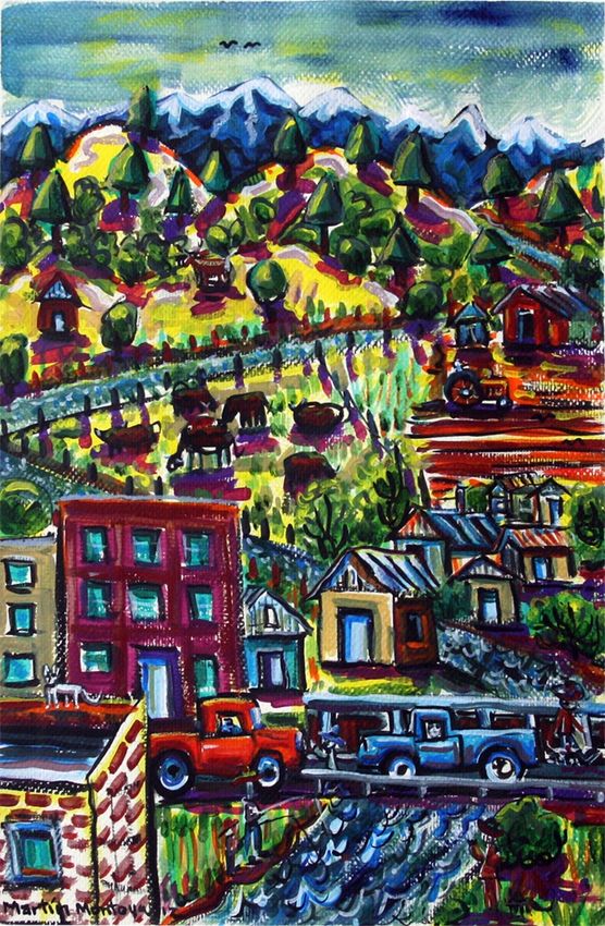
Cover(painting(by(Martin(Montoya(titled:(Las(Vegas(and(the(Gallinas(Watershed(
(
(

TABLE&OF&CONTENTS&
(

TABLE(OF(CONTENTS(................................................................................................................................(i(
LIST(OF(TABLES(.......................................................................................................................................(iii(
LIST(OF(FIGURES(.....................................................................................................................................(iii(
LIST(OF(MAPS(.........................................................................................................................................(iii(
LIST(OF(ABBREVIATIONS(.........................................................................................................................(iv(
ACKNOWLEDGEMENTS(............................................................................................................................(v(
INTRODUCTION(.......................................................................................................................................(1(
GEOGRAPHICAL,(ECOLOGICAL,(SOCIAL,(AND(HISTORICAL(CONTEXT(.........................................................(1(
    History(.................................................................................................................................................(2(
    Climate(................................................................................................................................................(2(
    Vegetation(...........................................................................................................................................(4(
    Land(Use(..............................................................................................................................................(4(
    Forest(Thinning(....................................................................................................................................(4(
    Species(of(Concern,(T&E(species(..........................................................................................................(5(
PROJECT(OVERVIEW(................................................................................................................................(5(
ECOLOGICAL(CONDITION(ASSESSEMNT....................................................................................................(6(
    Fluvial(Geomorphology(........................................................................................................................(7(
       Methods(..........................................................................................................................................(7(
       Findings(.........................................................................................................................................(10(
    New(Mexico(Rapid(Assessment(Method.............................................................................................(10(
       Methods(........................................................................................................................................(10(
       Findings(.........................................................................................................................................(11(
    Stream(Walkthrough(..........................................................................................................................(11(
       Methods(........................................................................................................................................(11(
       Findings(.........................................................................................................................................(13(
    Trail(Assessment(and(Design(..............................................................................................................(19(
       Methods(........................................................................................................................................(19(
       Findings(.........................................................................................................................................(19(
    Log(Dam(Assessment(and(Design(.......................................................................................................(20(

Updated'Watershed'Based'Plan'for'the'Upper'Gallinas'River'–'National'Forest'Addendum!                                                                Page!i!
(
Methods(........................................................................................................................................(20(
Findings(.........................................................................................................................................(20(
Information(Gaps(...............................................................................................................................(21(
SOCIAL(CONDITION(ASSESSEMNT(..........................................................................................................(22(
Public(Opinion(Survey(........................................................................................................................(22(
Discussions(with(USFS(Staff(................................................................................................................(23(
NEPA(.................................................................................................................................................(23(
MANAGEMENT(AND(RESTORATION(MEASURES(.....................................................................................(24(
Management(Measures(.....................................................................................................................(24(
Recreational(Use(Management(–(Trails(..........................................................................................(25(
Recreational(Use(Management(–(Intensively(Used(Recreation(Areas(..............................................(28(
Roads(.............................................................................................................................................(29(
Livestock(Management(..................................................................................................................(29(
Noxious/Invasive(Weed(Treatment(................................................................................................(30(
Beaver(Management(......................................................................................................................(31(
Restoration(Measures(........................................................................................................................(31(
Stream(Channel(Restoration(..........................................................................................................(31(
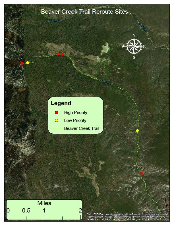
Map(5(H(Recommended(trail(reroutes,(logHdam(repairs,(riparian(planting(and(exclosures(on(Beaver(
Creek.(............................................................................................................................................(34(
Riparian(Planting(............................................................................................................................(35(
Native(Cutthroat(Trout(Reintroduction(...........................................................................................(35(
Beaver(Reintroduction(...................................................................................................................(35(
Conservation,(Planning(and(Regulatory(Measures(..............................................................................(36(
Conservation(..................................................................................................................................(36(
Planning(and(Collaboration(............................................................................................................(37(
Regulations(and(Guidelines(............................................................................................................(37(
Education(and(Outreach(Measures(....................................................................................................(37(
MANAGEMENT(AND(RESTORATION(MEASURE(PRIORITIES(AND(ASSOCIATED(LOAD(REDUCTIONS(..........(38(
IMPLEMENTATION(SCHEDULE(...............................................................................................................(39(
TECHNICAL(AND(FINANCIAL(ASSISTANCE(NEEDED(..................................................................................(41(
MEASURABLE(MILESTONES(OF(IMPLEMENTATION(................................................................................(46(
Quantitative(Measurable(Milestones(.................................................................................................(46(
Qualitative(Measureable(Milestones(..................................................................................................(47(
Updated'Watershed'Based'Plan'for'the'Upper'Gallinas'River'–'National'Forest'Addendum! Page!ii!
(
CRITERIA(FOR(EVALUATING(LOAD(REDUCTION(ACHIEVEMENTS(.............................................................(47(
MONITORING(PROGRAM(.......................................................................................................................(48(
REFERENCES(..........................................................................................................................................(50(
Appendix(A:(Public(Opinion(Survey(........................................................................................................(53(
Appendix(B:(Log(Dam(Assessment(Data(Sheet(........................................................................................(56(
(

LIST&OF&TABLES&
Table(1(H(Project(area(description(for(the(Updated(Watershed(Based(Plan(and(National(Forest(Addendum(
for(the(Upper(Gallinas(River(.....................................................................................................................(1(
Table(2(H(Substrate(Categories(by(Size((Mecklenburg)(..............................................................................(9(
Table(3(H(Walkthrough(by(stream(section(...............................................................................................(12(
Table(4(H(General(observations(of(issues(and(opportunities(made(during(Fluvial(Geomorphology,(
NMRAM(and(the(Stream(Walkthrough(in(no(particular(order.((Refer(to((Mahan(Saleem,(2017)(for(more(
details.(The(FS#(listed(refers(to(the(sampling(location(where(the(issue(is(found.(....................................(14(
Table(5(H(Implementation(schedule(of(Management(and(Restoration(Measures,(Conservation,(Planning(
and(Regulatory(Measures,(and(Education(and(Outreach(Measures(–(two(phases(of(implementation(with(
each(phase(being(3(years(.......................................................................................................................(39(
Table(6(H(Financial(resources(needed(to(support(recommended(Management(and(Restoration(Measures(
and(Education(and(Outreach(activities(...................................................................................................(41(
Table(7(H(Potential(funding(sources(for(implementation.(........................................................................(43(
Table(8(H(Technical(assistance(available(from(collaborating(organizations(and(individuals.(.....................(45(
Table(9(H(Effectiveness(Monitoring(Schedule(..........................................................................................(48(
(
LIST&OF&FIGURES&
Figure(1(H(Screens(showing(the(pages(of(the(walkthrough(form(used(in(the(Juno(3B.(..............................(13(
Figure(2(H(Channel(widening(caused(by(manHmade(log(dam.(..................................................................(21(
Figure(3(H(Instream(restoration(conceptual(design(for(Porvenir(Creek(on(El(Porvenir(Christian(Camp(
property(................................................................................................................................................(32(

LIST&OF&MAPS&
Map(1(H(Project(area(for(the(Watershed(Based(Plan(for(Upper(Gallinas(Watershed(and(this(National(
Forest(Addendum(with(USGS(Hydrologic(Unit(Code((HUC)(Boundaries(.....................................................(3(
Map(2(H(Monitoring(Sites(in(the(Upper(Gallinas(Watershed.(.....................................................................(8(
Map(3(H(Recommended(trail(repair(sites(................................................................................................(26(
Map(4(H(Recommended(trail(reroute(locations(.......................................................................................(27(
Map(5(H(Recommended(trail(reroutes,(logHdam(repairs,(riparian(planting(and(exclosures(on(Beaver(Creek.
(..............................................................................................................................................................(34(

Updated'Watershed'Based'Plan'for'the'Upper'Gallinas'River'–'National'Forest'Addendum!                                                                 Page!iii!
(

&

&LIST&OF&ABBREVIATIONS&
(

ABBREVIATION'        DEFINITION'
ARMAS(               Achieving(in(Research(Math(and(Science(–(Internship(
                     program(at(NM(Highlands(University(
AU(                  Assessment(Unit(
BMP(                 Best(Management(Practice(
CWA(                 Clean(Water(Act(
EPA(                 Environmental(Protection(Agency(
GIS(                 Geographic(Information(Systems(
HPWA(                Hermit’s(Peak(Watershed(Alliance(
HQCWAL(              High(Quality(Coldwater(Aquatic(Life(
HQCWF(               High(Quality(Coldwater(Fishery(
HWI(                 Healthy(Watersheds(Initiative(
LA(                  Load(Allocation(
LV(                  Las(Vegas(
MMR(                 Management(and(Restoration(Measure(
MOS(                 Margin(of(Safety(
NEPA(                National(Environmental(Policy(Act(
NFL(                 National(Forest(Lands(
NM(                  New(Mexico(
NMED(                New(Mexico(Environment(Department(
NMHU(                New(Mexico(Highlands(University(
NMOSE(               New(Mexico(Office(of(State(Engineer(
NRCS(                Natural(Resources(Conservation(Service(
QAPP(                Quality(Assurance(Project(Plan(
SMC(                 San(Miguel(County(
SSTEMP(              Stream(Segment(Temperature(Model(
SWCD(                Soil(and(Water(Conservation(District(
SWQB(                Surface(Water(Quality(Bureau(
TMDL(                Total(Maximum(Daily(Load(
USEPA(               United(States(Environmental(Protection(Agency(
USFS(                United(States(Forest(Service(
USGS(                United(States(Geological(Survey(
UWC(                 United(World(College(
W/D,(or(W:D(         Width(to(depth(ratio(
WBP(                 Watershed(Based(Plan(
WLA(                 Waste(Load(Allocation(
WQCC(                Water(Quality(Control(Commission(
WQS(                 Water(Quality(Standards(
(                              !

Updated'Watershed'Based'Plan'for'the'Upper'Gallinas'River'–'National'Forest'Addendum!   Page!iv!
(
ACKNOWLEDGEMENTS&
(
Heartfelt(thanks(to(all(the(following(people(that(contributed(to(this(project:(
'
   •! US(Forest(Service(Staff:(
                o! Steve(Romero(
                o! Alberta(Maes(
                o! Melvin(Danny(Burton(
                o! James(Munoz(
                o! Sarah(Naegele(
                o! Mike(Lujan(
                o! Cecil(Rich(
                o! Carlos(Lovato((
                o! Annmarie(Kmetz(
                o! Esther(Nelson(
                     (
   •! Jeff(Ogburn,(NM(Game(and(Fish(Department(
   •! Devin(Kennemore,(Pathfinder(Environemental(
   •! Margie(Tatro(and(Mark(Reineke,(Reineke(Construction(
   •! Kathryn(Mahan,(KI(Bar(Consulting(
   •! Craig(Sponholtz,(Watershed(Artisans(
    •!   Daniel(Unruh&

Updated'Watershed'Based'Plan'for'the'Upper'Gallinas'River'–'National'Forest'Addendum!   Page!v!
(
INTRODUCTION&

This(addendum(to(the(Updated'Watershed'Based'Plan'for'the'Upper'Gallinas'River((HPWA,(2012)(
addresses(National(Forest((NF)(lands(managed(by(the(U.S.(Forest(Service(within(the(Santa(Fe(National(
Forest(in(the(Upper(Gallinas(Watershed.((The(2012(Watershed(Based(Plan(only(addressed(private(lands(
in(the(Upper(Gallinas(River(Watershed.(

Even(though(stream(reaches(in(the(National(Forest(are(not(listed(as(impaired(they(contribute(directly(to(
water(quality(of(impaired(reaches(found(lower(in(the(watershed.((The(better(the(water(quality(that(
provides(the(source(for(impaired(reaches,(the(easier(it(will(be(to(reduce(those(impairments.((
Furthermore,(to(ignore(watershed(conditions(upstream(of(impaired(reaches(does(little(to(approach(
watershed(restoration(and(management(in(a(holistic,(basinHwide(manner.(((

This(addendum(does(not(reiterate(information(that(is(presented(in(the(Updated'Watershed'Based'Plan'
for'the'Upper'Gallinas'River'(WBPGR)((HPWA,(2012);(that(document(provides(the(background(to(
accompany(this(document.(((

GEOGRAPHICAL,&ECOLOGICAL,&SOCIAL,&AND&HISTORICAL&CONTEXT&

The(Upper(Gallinas(Watershed(is(a(subHwatershed(of(the(Pecos(Watershed(and(is(located(in(
northeastern(New(Mexico.(The(watershed(is(48,968(acres((76(mile2)(from(its(headwaters(on(Elk(
Mountain(to(the(Las(Vegas(Diversion(near(Montezuma,(NM,(including(Porvenir(Canyon(to(the(
headwaters(of(Beaver(Creek.(This(total(of(32.5(miles(of(stream(length(descends(from(11,661’(to(6,800’.((

The(geographic(area(covered(by(this(National(Forest(addendum(includes(Hydrologic(Units(numbered(
130600010801(and(130600010802((see(Map(1)(and(includes(the(upper(reaches(of(the(Gallinas(River((aka(
Gallinas(Creek)(and(the(National(Forest(lands(of(Porvenir(Creek(and(its(headwater(stream(Beaver(Creek.((
Table(1(provides(a(description(of(this(entire(upper(Gallinas(Watershed.((The(National(Forest(in(the(Upper(
Gallinas(Watershed(covers(52%(of(the(watershed’s(landscape((SWQB,(NMED,(2005)(or(a(total(of(25,463(
acres.(

(
Table'1'='Project'area'description'for'the'Updated'Watershed'Based'Plan'and'National'Forest'Addendum'for'the'Upper'
Gallinas'River'

NAME'            Assessment'          HUC'(12)'            HUC'SIZE' MAIN'                  DESCRIPTION'
                 Units'                                    (acres)'  STEM'
                                                                     LENGTH'
                                                                     (miles)'
Porvenir(        NMH2212H01;(         130600010801(        18,028.6(      14.4(             Entire(length(of(Porvenir(
Canyon((         NMH2212_04;(                                                               Cr.(up(to(headwaters(of(
                 NMH2212_05(                                                                Beaver(Cr.(

Gallinas(Cr.(    NMH2212_02(          130600010802(        16,072.9(      12.4(             Gallinas(Cr.(from(
                                                                                            confluence(with(

Updated'Watershed'Based'Plan'for'the'Upper'Gallinas'River'–'National'Forest'Addendum!                            Page!1!
(
NAME'          Assessment'        HUC'(12)'          HUC'SIZE' MAIN'              DESCRIPTION'
               Units'                                (acres)'  STEM'
                                                               LENGTH'
                                                               (miles)'

                                                                                  Porvenir(Cr.(up(to(its(
                                                                                  headwaters(

Gallinas(R.(   NMH2212_00(        130600010805(      14,866.6(    5.7(            Gallinas(R.(from(Las(
                                                                                  Vegas(Diversion(to(its(
                                                                                  confluence(with(
                                                                                  Porvenir(Cr.(

TOTAL'         '                  1306000108'        48,968'      32.5'miles'     '
                                                     acres'

(

History&
The(current(day(National(Forest(in(the(Upper(Gallinas(Watershed(were(designated(as(public(in(1892(as(
the(Pecos(River(Forest(Reserve.((It(was(later(combined(with(the(Jemez(Forest(Reserve(to(become(the(
Santa(Fe(National(Forest(in(1915.((The(Las(Vegas(District(was(distinct(until(1980(when(it(was(combined(
with(the(Pecos(District(and(is(now(known(as(the(Pecos/Las(Vegas(District(with(two(ranger(stations,(one(
in(Las(Vegas(and(one(in(Pecos.(((

In(1964(Congress(designated(more(than(168,000(acres(as(the(Pecos(Wilderness(and(in(1980(added(
55,000(acres(for(a(total(of(223,222(acres(with(198,597(acres(within(the(Santa(Fe(National(Forest(and(
24,736(acres(in(the(Carson(National(Forest.((The(upper(reaches(of(both(Gallinas(Creek(and(Beaver(Creek(
are(within(the(Pecos(Wilderness.(

Climate&
The(climate(in(the(Upper(Gallinas(Watershed(and(the(Las(Vegas,(NM(area(is(defined(by(both(the(Rocky(
Mountains(to(the(west(and(the(plains(to(the(east.(Precipitation(is(variable(in(annual(and(seasonal(totals.(
Winter(precipitation(in(particular(is(variable(and(winter(snowmelt(provides(the(base(flow(for(both(the(
Gallinas(River(and(Porvenir(Creeks.(Summer(monsoons(are(typically(brief(and(intense(and(usually(occur(
between(July(and(September.((Average(annual(precipitation(for(Las(Vegas(is(16.3(inches((1941H2005),(
and(average(annual(accumulated(precipitation(at(Wesner(Springs(Snotel(station((elev.(11,120(ft)(is(38.3(
inches((NRCS,(2014).(Average(maximum(temperature(for(June,(July(and(August(is(approximately(80(̊F(
(26.7˚F),(and(average(temperature(for(June,(July(and(August(at(Wesner(Springs(is(50˚F((10˚C)((NRCS,(
2014).(

Updated'Watershed'Based'Plan'for'the'Upper'Gallinas'River'–'National'Forest'Addendum!                Page!2!
(
!
         Map$1$&$Project$area$for$the$Watershed$Based$Plan$for$Upper$Gallinas$Watershed$and$this$National$Forest$Addendum$with$USGS$Hydrologic$Unit$Code$(HUC)$Boundaries$

                                                                                         $

Updated'Watershed'Based'Plan'for'the'Upper'Gallinas'River'–'National'Forest'Addendum!                                                                                        Page!3!
!
Vegetation) The!vegetation!in!the!National!Forest!is!comprised!of!a!variety!of!ecoregions.!!Below!the!National!Forest! at!lower!elevations!(6,400!–!7,400!feet)!the!uplands!between!the!City!of!Las!Vegas!gaging!station!and! the!USFS!boundaries!on!both!Gallinas!River!and!Porvenir!Creek!are!predominately!comprised!of! ponderosa!pine!(Pinus&ponderosa)!and!oak!scrub!forests.!The!lower!elevation!bottomlands!or!riparian! areas!are!comprised!of!narrowleaf!cottonwood!(Populus&angustifolia),!willow!species,!predominately! bluestem!willow!(Salix&irrorata),&and&thinleaf!alder!(Alnus&incana&ssp&tenuifolia).!!Above!the!USFS! boundary!is!the!mixed!conifer!vegetation!zone,!comprised!of!ponderosa!pine!(Pinus&ponderosa),! DouglasQfir!(Pseudotsuga&menziesii),!white!fir!(Abies&concolor)&and!blue!spruce!(Picea&pungens).!The! riparian!corridor!in!this!zone!contains!mixed!conifer!species,!thinleaf!alder,!willow!species!and! occasionally!aspen!(Populus&tremuloides).!!! ! Ecological!Site!and!Soils!data!is!not!available!from!the!USDA!NRCS!for!over!99%!of!the!Upper!Gallinas! Watershed!(USDA:!NRCS,!2014).! Land)Use) Land!uses!of!the!National!Forest!in!the!Upper!Gallinas!Watershed!are!comparable!to!other!areas!in!the! Santa!Fe!and!Carson!National!Forests.!!Firewood,!timber!harvesting!and!livestock!grazing!are!the!primary! consumptive!uses.!!Some!gathering!of!medicinal!plants!and!native!food!plants!(e.g.!mushrooms)!and! natural!items!for!cottage!industries!(e.g.!lichen!rocks,!moss)!may!occur!but!are!not!regulated!nor!are! substantial.!!The!Gallinas!and!Porvenir!Creeks!are!managed!as!a!coldwater!fishery!for!a!selfQsustaining! population!of!brown!and!stocked!rainbow!trout.!Outdoor!recreation!comprises!a!significant!and! consistent!public!use!of!these!National!Forest!lands.!!Hunting,!fishing,!horseback!riding,!camping!and! hiking!are!the!most!common!types!of!outdoor!recreation!with!some!use!for!winter!crossQcountry!skiing! and!snowshoeing.!!The!two!major!trail!systems!are:!the!Porvenir!Canyon!trail!#247!that!follows!Porvenir! Cr.!to!the!headwaters!of!Beaver!Cr.!and!the!Gallinas!Creek!trail!#!216!that!follows!the!Gallinas!Cr.!to! Burro!Basin.!! ! Porvenir!Canyon!and!the!Gallinas!Headwaters/!Burro!Basin!areas!are!available!for!livestock!grazing.! Currently,!two!grazing!permits!exist!–!one!that!covers!the!majority!of!the!Upper!Gallinas!and!one!is! primarily!in!the!Tecolote!Watershed!with!a!small!portion!in!the!Upper!Gallinas.!! A!number!of!private!inQholdings!exist!in!the!National!Forest!along!the!upper!reaches!of!Gallinas!Creek! between!the!EV!Long!Campground!and!Calf!Canyon!including!Evergreen!Valley.!!Many!of!the!inQholdings! include!the!creek.!!These!inQholdings!are!longQterm!leases!with!USFS!and!most!have!a!summer!home.!!!.! The!El!Porvenir!Christian!Camp!immediately!upstream!of!the!USFS!Porvenir!Campgrounds!is!another! substantial!inQholding.!!Below!the!forest!service!boundary,!private!lands!are!used!for!grazing!and!the! river!is!diverted!for!irrigation!of!agriculture!and!pasture!lands.!In!addition,!many!residences!in!this!area! occur!near!the!river!and/or!within!the!100Qyear!floodplain!and!are!vulnerable!to!flood!impacts.!The! primary!access!road!(NM!Hwy!65/!FR!263)!follows!and!crosses!the!river!at!several!places!in!the!Gallinas! Canyon!and!has!also!been!impacted!by!past!flooding.!! Forest)Thinning) National!Forest!lands!in!the!Upper!Gallinas!Watershed!are!currently!undergoing!forest!thinning!activities! set!forth!in!the!Environmental&Assessment&for&the&Gallinas&Municipal&Watershed&Wildland@Urban& Updated'Watershed'Based'Plan'for'the'Upper'Gallinas'River'–'National'Forest'Addendum! Page!4! !
Interface&Project!(USDA!Forest!Service,!2005).!!A!total!of!7,775!acres!of!treatment!were!planned!in!that!
EA.!!!Forest!thinning!prescriptions!followed!by!some!post!thinning!treatment!(e.g.!prescribed!fire)!were!
planned!for!5,936!acres.!!The!remaining!1,839!acres!have!burn!only!planned!treatments.!!To!date!4,284!
acres!have!been!thinned!with!1,652!acres!remaining.!!!
The!watershed!condition!assessments!and!this!addendum!did!not!address!forest!thinning!and!fire!
prevention!since!the!USFS!and!others!have!devoted!considerable!efforts!to!this!and!treatment!plans!
have!been!well!underway!since!2005.!
Species)of)Concern,)T&E)species)
A!few!threatened!and!endangered!and!rare!species!potentially!occur!in!the!National!Forest!of!the!Upper!
Gallinas!Watershed.!!These!species!should!be!considered!when!planning!projects!in!the!area;!they!are!
particularly!important!when!completing!NEPA,!404!Permits!or!other!regulatory!needs.!!Those!species!
are:!
•! Mexican!Spotted!Owl,!Strix&occidentalis&lucida!(Federal!Threatened)!
•! Northern!Goshawk,!Accipiter&gentilis!(Rare)!
•! Southwest!Willow!Flycatcher,!Empidonax&traillii!(Federal!Endangered)!
•! New!Mexico!Jumping!Mouse,!Zapus&luteus&luteus!(Federal!Endangered)!
Native!Cutthroat!Trout!(Oncorhynchus&clarkii)!historically!existed!in!the!Gallinas!Creek!and!
Porvenir/Beaver!Creek.!!While!they!are!not!currently!listed,!they!are!extremely!rare.!!They!have!likely!
been!extirpated!from!the!Upper!Gallinas!Watershed!but!rumors!from!local!fisherman!indicate!that!they!
might!still!occur!in!the!upper!reaches!of!Gallinas!Creek.!
PROJECT)OVERVIEW)
The!Updated!Watershed!Based!Plan!for!the!Upper!Gallinas!River!(WBPGR)!is!the!foundational!document!
upon!which!this!Addendum!is!based!(HPWA,!2012).!!This!addendum!does!not!reiterate!discussions!in!the!
WBPGR!related!to!stream!impairments!and!other!background!information;!that!document!still!provides!
the!basic!elements!of!the!WBP.!!This!Addendum!only!addresses!ecological!and!social!conditions!and!
recommended!Management!and!Restoration!Measures!to!remediate!degraded!conditions!on!National!
Forest!lands.!
In!order!to!add!the!National!Forest!to!the!WBPGR,!an!ecological!and!social!condition!assessment!was!
completed!to!help!identify!projects!needed!to!improve!overall!watershed!health!and!ensure!the!best!
water!quality!possible!in!streams!that!contribute!to!downstream!temperature!impaired!reaches.!!!
A!subcontractor!was!hired!to!conduct!the!Ecological!Condition!Assessment!and!a!detailed!report!
contains!the!specifics!of!that!assessment!(Mahan!Saleem,!2017).!!The!methods!used!to!assess!ecological!
conditions!are!discussed!below;!the!assessment!included:!
•! Fluvial!geomorphology!(Rosgen!Level!II),!!
•! Riparian!condition!(New!Mexico!Rapid!Assessment!Method,!Montane!Riverine!Wetlands!
subclass,!version!2.1),!and!
•! Degraded!site!identification!with!a!Stream!Walkthrough.!
!
Updated'Watershed'Based'Plan'for'the'Upper'Gallinas'River'–'National'Forest'Addendum! Page!5!
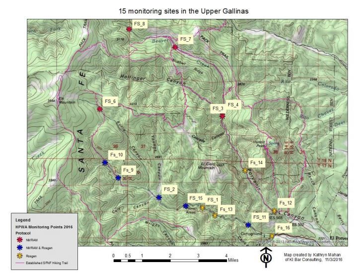
!Social!perceptions,!interests,!impediments!and!resources!were!then!examined!by!conducting!a!Public! Opinion!Survey,!having!numerous!discussions!with!USFS!staff!and!by!conducting!a!NEPA!review!of! recommended!projects.!! Information!from!the!ecological!and!social!conditions!assessment!was!then!used!to!recommend!projects! to!improve!degraded!conditions!within!the!social!context!of!the!area!and!plan!their!execution.!!These! recommendations!will!provide!the!support!and!direction!to!request!future!funding!to!put!this!plan!into! action.! ECOLOGICAL)CONDITION)ASSESSEMNT) The!primary!focus!of!this!ecological!condition!assessment!was!to!understand!factors!that!contribute!to! the!degradation!of!National!Forest!streams!as!they!relate!to!the!temperature!impairment!in!the!Gallinas! River!downstream!of!the!National!Forest!boundary!(the!river!has!failed!to!meet!New!Mexico! Environment!Department!Water!Quality!Standards)!(HPWA,!2012).!The!Upper!Gallinas!River! temperature!impairment!is!attributed!primarily!to!a!lack!of!canopy!cover!(low!stream!shade),!along!with! excessive!stream!width!and!low!flows.!Some!of!the!contributing!factors!of!low!stream!shade!include! stream!entrenchment,!streambank!erosion,!a!lack!of!floodplain!connectivity,!livestock!grazing,! agricultural!fields,!roads,!residential!development,!recreational!use,!and!natural!conditions!that!might! prohibit!woody!vegetation.!More!information!on!the!temperature!impairment!in!the!Upper!Gallinas! River,!including!other!possibly!variables,!can!be!found!on!pages!10Q15!of!the!Updated&Watershed&Based& Plan&for&the&Upper&Gallinas&River!(WBPGR)!(HPWA,!2012).! ! Field!assessments!done!by!HPWA!to!form!the!basis!of!this!WBP!Addendum!consisted!of!fluvial! geomorphology!(Rosgen!Level!II),!riparian!condition!(New!Mexico!Rapid!Assessment!Method,!Montane! Riverine!Wetlands!subclass,!version!2.1),!and!the!identification!of!degraded!sites!with!a!Stream! Walkthrough!approach.!!Temperature!and!shade!assessment!was!not!conducted!since!temperature!data! collected!during!the!WBPGR!project!and!On@the@Ground&Improvement&Projects&Phase&I!both!indicated! that!stream!reaches!in!the!National!Forest!all!met!temperature!standards.! ! Fifteen!sampling!sites!were!chosen!for!geomorphology!and/or!riparian!condition!assessment!(ten!sites! per!assessment);!five!sites!were!assessed!only!with!NMRAM,!five!sites!were!assessed!only!with!the! geomorphology!protocols,!and!five!sites!were!assessed!with!both!protocols!(see!Map!2).!In!addition,! nearly!25!miles!of!stream!were!evaluated!using!the!walkthrough!method!(see!Table!3!for!more!detail).!!! ! These!studies!occurred!prior!to!significant!thinning!projects!that!occurred!along!approximately!2.5!miles! of!the!Gallinas!Creek!upstream!of!EV!Long!Campground!(the!Steelers!and!Broncos!Units).!!These!thinning! projects!were!done!very!near!to!the!stream!channel!and!include!steep!slopes!uphill!of!the!stream.!! Thinning!was!covered!in!the!Environmental&Assessment&for&the&Gallinas&Municipal&Watershed&Wildland@ Urban&Interface&Project&(USFS,!2005).!!No!post!thinning!sampling!occurred!of!stream!or!riparian! conditions.!!Future!assessment!of!these!sites!should!occur!with!comparable!methodology!used!in!this! baseline!study.!! Updated'Watershed'Based'Plan'for'the'Upper'Gallinas'River'–'National'Forest'Addendum! Page!6! !
Fluvial)Geomorphology)
Methods)
Stream&Channel&Reference&Sites:&An&Illustrated&Guide&to&Field&Technique&I&(Harrelson,!1994)!was!used!as!a!
guide!for!determining!stream!channel!conditions;!crossQsections,!longitudinal!profiles!and!pebble!counts!
were!all!done!as!part!of!the!assessment.!The!purposes!of!gathering!fluvial!geomorphology!data!were:!to!
have!baseline!data!for!monitoring!trends!in!geomorphic!condition!over!time;!to!evaluate!watershed!
wide!geomorphic!condition;!and!to!use!the!data!to!potentially!determine!areas!in!need!of!restoration.!!
Sites!for!possible!restoration!were!identified!by!fringe!characteristics!in!the!crossQsectional!data!for!a!
particular!stream!type,!in!particular!entrenchment!ratio,!in!combination!with!the!NMRAM!scores.!!
!
Geomorphologic!data!can!also!be!used!to!identify!bimodal!distribution!of!sediments!(pebble!count)!
which!is!an!indicator!of!atQrisk!stream!systems,!due!to!erosion!and!deposition!of!fine!particles.!High!
sediment!loads!can!decrease!dissolved!oxygen!in!the!water,!scour!streambeds!leading!to!higher!
mortality!among!aquatic!invertebrates,!negatively!impact!the!aquatic!plant!community,!and!result!in!
“embeddness”!where!the!spaces!between!substrate!become!filled,!decreasing!spawning!habitat!and!
locations!to!lay!eggs.!Such!a!bimodal!distribution!would!most!simply!be!observed!as!two!peaks!(“two!
modes”)!on!a!pebble!count!chart.!This!methodology!is!a!nationally!and!USFS!recognized!manual!for!
fluvial!channel!dynamics!and!is!similar!to!the!nationally!recognized!Rosgen!Level!II!(Rosgen!D.!,!1996).!!
!
The!cross!section!and!longitudinal!profiles!can!be!accomplished!with!one!person!(if!using!a!laser!level)!
but!a!team!of!two!is!far!more!efficient.!This!method!can!take!between!1!and!3!hours!depending!on!the!
accessibility!of!the!site!and!the!length!of!the!longitudinal!profile.!It!is!important!to!note!that!the!
prescribed!longitudinal!profile!runs!approximately!20!times!the!bankfull!width,!or!300Q500!feet!
(Harrelson,!1994).!Sometimes!it!was!not!possible!to!obtain!this!full!measurement!for!a!variety!of!reasons!
including!dense!vegetation,!heavy!wrack,!topographic!or!other!obstruction,!site!inaccessibility,!or!
time/weather!constraints.!In!some!instances,!where!deep!pools!were!present!or!line!of!sight!to!the!
transit!was!otherwise!obstructed,!elevation!measurements!were!taken!at!water!surface!and!then!
calculated!based!on!depth!from!water!surface!to!bed.!These!measurements!are!included!on!our!
longitudinal!profile!charts!only!for!interest!of!the!reader,!and!occur!mostly!commonly!at!deep!pools.!
!

Updated'Watershed'Based'Plan'for'the'Upper'Gallinas'River'–'National'Forest'Addendum!              Page!7!
!
!!

                          Map$2$&$Monitoring$Sites$in$the$Upper$Gallinas$Watershed.$

!
!
!
!
!
!
!
!                              !

Updated'Watershed'Based'Plan'for'the'Upper'Gallinas'River'–'National'Forest'Addendum!   Page!8!
!
Pebble!counts,!the!third!component!of!the!geomorphology!survey,!similarly!can!be!completed!by!one!
person!using!a!metric!rule!or!tape!measure,!but!is!more!efficient!with!two!individuals.!It!takes!on!
average!an!hour!per!count.!!Pebble!count!substrates!are!identified!accordingly:!!
$
Table$2$&$Substrate$Categories$by$Size$(Mecklenburg)$
Size$
Range$
$$ $$ (mm)$ $$
Material$ Low$ mid$ High$
Silt/Clay! 0! 0.03& 0.062!
Sand! 0.062! 1.0& 2!
Gravels! 2! 3& 4!
!! 4! 6& 8!
!! 8! 12& 16!
!! 16! 24& 32!
!! 32! 48& 64!
Cobbles! 64! 96& 128!
!! 128! 192& 256!
Boulders! 256! 384& 512!
!! 512! 768& 1024!
!! 1024! 1536& 2048!
Bedrock! 2048! 3072& 4096!
!
Entrenchment!ratio!(ENT)!is!defined!as!the!width!of!the!floodQprone!area/bankfull!width!(Wfpa/Wbkf).!
(Bankfull!determinations!were!crossQchecked!with!regional!curves!for!the!area.)!When!ENT!is!near!the!
low!end!of!its!range!(or!exhibits!more!incision),!the!stream!is!potentially!at!risk!of!losing!access!to!the!
floodplain.!According!to!(Zeedyk,!2009),!an!entrenchment!ratio!over!1.5!is!considered!“high,”!a!ratio!
between!1.2!and!1.5!is!“moderate,”!and!less!than!1.2!is!considered!“low.”!!
!
ENT!Ratio! Connectedness!of!stream!
Wfpa/wbkf! to!floodplain!
>1.5! High!
1.2Q1.5! Moderate!! Channel!geomorphology!was!completed!at!ten!of!fifteen!sites.!The!data!for!geomorphology!is!presented! in!text!and!crossQsectional!graphs!following!individual!summaries!of!each!site.!It!is!important!to!note! that!the!blue!line!represents!bankfull,!or!the!twoQyear!flow!that!shapes!the!channel.!The!red!line! represents!a!15Qyear!flood,!or!the!flood!that!forms!the!floodplain.!!The!area!within!the!red!line!is!the! floodQprone!area.!! ! Findings) Detailed!results!of!fluvial!geomorphology,!riparian!condition,!and!identification!of!degraded!sites!are! presented!in!Watershed&Condition&Assessment&–&National&Forest&in&the&Upper&Gallinas&Watershed! (Mahan!Saleem,!2017).! The!fluvial!geomorphology!study!found!that!the!majority!of!study!sites!had!a!high!entrenchment!ratio!–! meaning!that!they!are!well!connected!to!their!floodplain!(the!river!can!easily!access!its!floodplain!during! high!waters).!Only!one!site!had!a!moderate!entrenchment!ratio.!!While!some!areas!were!found!to!be! moderately!entrenched!during!the!Stream!Walkthrough!(see!below)!and!general!observations!(e.g.!site! FS9!in!one!location),!most!stream!reaches!are!not!considered!entrenched,!so!restoration!to!repair!this! degraded!condition!is!not!generally!needed!in!National!Forest!areas!of!the!Upper!Gallinas!Watershed.!! New)Mexico)Rapid)Assessment)Method) Methods) HPWA!measured!land!and!stream!health!using!the!New!Mexico!Rapid!Assessment!Method:!Montane! Riverine!Wetlands!(NMRAM)!v!2.1!protocol!at!ten!of!fifteen!sites.!This!method!uses!several!different! metrics!to!assess!landscape!health!(available!nutrient!buffer,!and!context!of!the!site!within!a!larger! landscape),!biotic!health!(plant!communities,!physical!structure,!and!diversity),!and!abiotic!health!(river! channel!shape!and!function!and!landscape!diversity).!! ! This!method!takes!4Q5!hours!per!site!and!is!most!efficient!when!performed!by!three!trained!individuals.! Ideally,!the!crew!member!most!comfortable!with!local!vegetation!identification!will!complete!the! vegetation!mapping!(biotic)!portion!of!the!assessment!while!the!other!two!crew!members!take!stream! measurements!(abiotic!portion!of!assessment);!the!landscape!portion,!as!well!as!the!checklists!based!on! general!observation!rather!than!specific!measurements!found!in!both!the!biotic!and!abiotic!portions!of! the!NMRAM,!are!most!efficiently!(and!likely!most!accurate!when)!completed!jointly!by!all!three! members!of!the!field!crew.! ! Landscape!health!measurements!included!buffer!integrity,!riparian!corridor!connectivity,!relative! wetland!size!(compared!to!historic!size),!and!surrounding!land!use.!!Biotic!health!measurements! included!relative!native!plant!community!composition,!vegetation!horizontal!patch!structure,!vegetation! vertical!structure,!native!riparian!tree!regeneration,!and!invasive!exotic!plant!species!cover.!Within!this! portion!of!the!method,!vegetation!communities!were!mapped!according!to!habitat!type,!adapted!for! wetlands!from!the!Hink!and!Ohmart!system.!Abiotic!measurements!included!hydrologic!connectivity! (river!to!floodplain),!physical!diversity!of!the!site,!channel!stability,!stream!bank!stability!and!cover,!and! soil!surface!condition.!Additionally,!the!aboveQdescribed!fluvial!geomorphology!measurements!were! performed!alongside!the!NMRAM!abiotic!assessment.!!! ! Updated'Watershed'Based'Plan'for'the'Upper'Gallinas'River'–'National'Forest'Addendum! Page!10! !
The!NMRAM!summary!rating!system!is!based!on!a!scale!of!1!to!4,!where!4!(3.25Q4)!is!considered!
excellent!condition,!3!(2.5Q3.25)!good,!2!(1.75Q2.5)!fair,!and!1!(1.0Q1.75)!poor.!Rationale!for!the!weighting!
in!the!score!rollQup!can!be!found!in!the!yetQtoQbeQpublished!field!manual,!as!it!differs!significantly!from!
the!weighting!system!used!in!versions!1.0!and!1.1.!Environmental!stressors!were!also!recorded,!and!
were!ranked!according!to!intensity!as!minor,!moderate,!or!intense.!
!
For!more!information,!or!to!obtain!a!copy!of!the!field!manual,!we!recommend!contacting!Maryann!
McGraw!in!the!Wetlands!Program!of!the!NMED.!
!

Findings)
All!10!sampling!sites!except!one!received!an!overall!score!of!excellent!condition;!the!exception!was!that!
one!site!was!considered!good.!!The!lowest!ranking!site!(score!3.24)!was!in!close!proximity!to!the!road!
and!near!to!a!day!use!area!so!it!had!physical!constraints,!a!large!number!of!stressors!and!its!historical!
wetland!size!was!reduced.!!Component!scores!(biotic,!abiotic,!landscape)!indicate!areas!where!some!
improvement!in!the!overall!score!could!potentially!be!achieved!with!restoration!activities.!!!

The!road!and!heavily!used!public!areas!are!all!in!close!proximity!to!the!Gallinas!River!between!EV!Long!
Campground!and!Evergreen!Valley.!!Reduction!of!riparian!vegetation,!bare!and!compacted!soils,!the!
road!itself!and!related!gabion!baskets!and!streambank!erosion!were!noted!in!most!of!these!areas!and!
posed!the!most!significant!stressor!on!riparian!habitat!condition!along!Gallinas!River.!!However,!the!
NMRAM!study!was!not!typically!sensitive!to!the!level!of!degradation!caused!by!these!human!uses.!

Besides!fluvial!geomorphology,!and!NMRAM!studies,!general!observations!were!made!while!visiting!
each!site;!those!observations!are!part!of!the!NMRAM!study!to!generally!observe!the!site!in!ways!that!
may!not!be!reflected!in!the!overall!score.!!These!observations!at!study!sites!when!combined!with!the!
Stream!Walkthrough!observations!provide!the!basis!of!some!recommendations.!!See!the!findings!in!the!
Stream!Walkthrough!section!for!a!summary!of!general!observation!of!degraded!conditions.!

Stream)Walkthrough)
The!principal!goal!of!conducting!a!Stream!Walkthrough!was!to!catalog!degraded!conditions!and!
restoration!opportunities!over!a!wide!area!to!supplement!more!detailed!data!collected!to!document!
baseline!conditions!at!specific!sampling!locations.!

Methods)
Two!observers!walked!either!in!the!stream!channel!or!immediately!adjacent!to!the!channel!armed!with!
a!highly!accurate!GPS!unit.!!Some!stream!reaches!were!so!close!to!the!road!that!observations!were!
made!by!driving.!!During!the!walkthrough!all!observed!degraded!conditions!and!restoration!
opportunities!were!recorded.!!The!catalog!was!spatially!accurate!to!enable!GIS!mapping!with!descriptive!
annotation!to!identify!the!type!of!feature.!!Walkthrough!inventories!focused!on!drainage!channels!but!
may!also!extend!to!adjacent!meadows,!wetlands!or!other!areas!of!importance.!

Stream!Walkthroughs!occurred!along!a!total!of!24.6!stream!miles!in!both!the!Gallinas!Creek!and!
Porvenir!Creek!drainages!(see!Table!3).!!In!order!to!catalog!the!location!and!identify!the!type!of!stream!
or!upland!issue!or!opportunity,!we!used!a!Juno!3B!Trimble!unit,!where!satellites!allowed,!to!record!
spatial!and!descriptive!data.!See!Figure!1!for!images!of!the!ArcPad!form!used!to!collect!Walkthrough!
data.!

Updated'Watershed'Based'Plan'for'the'Upper'Gallinas'River'–'National'Forest'Addendum!                Page!11!
!
Table$3$&$Walkthrough$by$stream$section$

Stream$Section$                               Miles$covered$in$Walkthrough$(approximation)$
Gallinas!Cr./!Gallinas!River!                 8.7!
Burro!Basin!                                  4.1!
Porvenir!Cr.!                                 4.8!
Hollinger!Cr.!                                0.8!
Beaver!Cr.!                                   6.2!
Total$                                        24.6$
!
!

Features!that!were!expected!to!be!encountered!and!those!of!significance!to!watershed!health!are!as!
follows:!

Upland!Erosion!Features!

    •! headcuts!
    •! surface!erosion!(pedestals,!rills)!
    •! excessive!bare!ground!

Drainage!Channel!Erosion!

    •!   eroding!stream!banks!or!channel!erosion!(headcuts)!
    •!   excessive!sedimentation!in!drainage!channel/!high!embeddedness!
    •!   channel!entrenchment!(moderate/severe)!
    •!   overQwide!channel!

Degraded!Vegetation!!

    •!   degraded!woody!vegetation!(lack!of!shade)!
    •!   degraded!herbaceous!vegetation!
    •!   lack!of!reproduction!
    •!   nonQnative!vegetation!dominance!

ManQmade!impacts!

    •!   trail!related!erosion!!
    •!   eroding!or!overQwidening!trail!or!livestock!crossings!
    •!   grazing!related!impacts!
    •!   camp!sites!
    •!   road!impacts!
    •!   gabion!baskets/bank!armoring!
    •!   diversions!
    •!   bridge!related!issues!
    •!   dams!(including!installed!oneQlog!dams)!
    •!   berms/channel!constraint!
         !

Updated'Watershed'Based'Plan'for'the'Upper'Gallinas'River'–'National'Forest'Addendum!         Page!12!
!
Fish!and!Macroinvertebrate!Habitat!(catalog!of!existing!conditions!to!identify!enhancement!
opportunities)!
•! Pool/Riffle!complex!
•! !Large!Woody!Debris!(LWD)!accumulations!adequate!to!form!hiding!cover!or!backwater!in!
stream!channel!
•! Habitat!diversity!features!Q!overhanging!banks,!back!water,!oxbows!
Beaver!sign!(catalog!of!existing!conditions!to!identify!enhancement!opportunities)!
•! foraging!
•! dams!!
•! dens!(bank!or!lodge)!
!
!
Figure$1$&$Screens$showing$the$pages$of$the$walkthrough$form$used$in$the$Juno$3B.$
!
Findings)
While!sampling!locations!for!fluvial!geomorphology!and!NMRAM!offer!specific!and!repeatable!
quantitative!data,!not!all!issues!and!opportunities!are!detected!with!those!studies.!!Issues!identified!
during!all!field!assessment!work!including!the!Stream!Walkthroughs!yielded!numerous!observations!of!
issues!and!opportunities!that!helped!to!develop!project!recommendations;!those!are!summarized!in!
Table!4.!!
Updated'Watershed'Based'Plan'for'the'Upper'Gallinas'River'–'National'Forest'Addendum! Page!13!
!Table&4&(&General&observations&of&issues&and&opportunities&made&during&Fluvial&Geomorphology,&NMRAM&and&the&Stream&Walkthrough&in&no&particular&order.&&Refer&to&
(Mahan&Saleem,&2017)&for&more&details.&The&FS#&listed&refers&to&the&sampling&location&where&the&issue&is&found.&
Issue/Opportunity& Description& Apparent& Areas&Affected& Remediation&
Causes&
ISSUES& ! ! ! !
Man%made!log!dams! man%made!log!dams!can! Improperly! Gallinas:!EV!Long!Campground,! Remove!or!repair!log!
cause!channel!widening,! constructed!and! downstream!of!Oak!Flats,!site!FS1,!lots! dam!with!notching!in!
sequestration!of!fine! sited!log!dams!in! of!them!along!first!half!of!trail!#216,!! center!of!stream,!
sediments! 1960’s,!70’s! ! reinforce!log!ends!with!
Porvenir:!Beaver!Cr.!trail!#247! rock,!replace!log!with!
meadows!near!Lone!Pine!Mesa!trail! rock!that!encourages!
development!of!a!
thalwag!
! ! ! ! !
Moderate!stream! Site!specific!stream! Human!use,!lack!of! Porvenir:!FS12!(Porvenir!Christian! Consider!instream!
entrenchment! entrenchment! riparian!vegetation! Camp),!FS14!(1.1!mi!up!Porvenir!Cr.)! restoration!with!log!or!
the!flood!erosion! ! boulder!structures!to!
Gallinas:!FS1!(between!Fishing!Hole!&! arrest!further!
Big!Pine),!FS11!(Oak!Flats),!FS13! entrenchment!
(Fishing!Hole),!downstream!most!
ephemeral!trib!to!Gallinas!Cr!severely!
downcut!maybe!unstable!
! ! ! ! !
Consequence!of!logging! Excessive!woody!debris,! Thinning!too!close! Steeler’s!and!Bronco!thinning!units!in! should!examine!
limited!riparian!vegetation! to!riparian!area,! Gallinas!Canyon! conditions!after!
remnant!large! riparian!thinning!that!
woody!debris!on! occurred!during!fall!
adjacent!steep! 2016!
slopes!
! ! ! ! !
Water!Diversions! Over%wide!channel,!adjacent! Diversion! Porvenir!Christian!Camp,!EV!Long! Evaluate!improvements!
streambank!erosion,!lack!of! construction! Campground!
riparian!veg.,!sequestration! method!
Updated'Watershed'Based'Plan'for'the'Upper'Gallinas'River'–'National'Forest'Addendum! Page!14!
!Issue/Opportunity& Description& Apparent& Areas&Affected& Remediation&
Causes&
of!sediments!
! ! ! ! !
Road!and!bridge! Road!too!close!to!stream! The!easiest!place! near!Fishing!Hole!day!use!area!(!FS13),! Relocate!the!road!but!
impacts! channel!constrains!the! to!build!a!road! in!many!areas!along!Gallinas!Cr.! probably!not!practical!
channel,!significantly!limits! between!EV!Long!Campground!and! in!most!locations,!more!
restoration!potential,!places! Evergreen!Valley! thorough!investigation!
the!road!in!jeopardy!during! ! needed!
flood!events!(as!seen!in!the!
2013!flood!event),!!has!
significantly!reduced!the!
overall!size!of!the!wetland!
plant!community!from!its!
historic!condition!
! ! ! ! !
Recreational!area! bare,!compacted!soils,! People!trampling!in! EV!Long!campground,!!Oak!Flats,! recommend!more!
impacts! streambank!erosion/bank! heavy!use!areas! Porvenir!Christian!Camp,!site!FS14!1.1! thorough!assessment!
slumping! miles!upstream!of!Porvenir! of!public!use!impacts!
Campground! and!explore!possible!
! remediation!measures!
! ! ! ! !
Gabion!baskets! Unstable!gabion!baskets!pose! Road!protection!! Just!downstream!of!Dubois!cabin!on! Remove!and!replace!
a!potential!stream!channel! Gallinas!Cr.,!! with!better/newer!
erosion!concern!should!they! structure!
become!dislodged!during!a!
flood!event!(some!of!them!
are!prone!to!failure)!
! Long!gabion!basket!between! Road!protection! Near!Fishing!Hole!day!use!area!(FS13)! Revegetate!at!their!
road!and!stream!eliminates! stabilize!the! Gallinas!Cr.! edges!to!compensate!
stream!shade!and!protection! streambank!! for!unvegetated!basket!
from!the!road! if!possible!
! ! ! ! !
Updated'Watershed'Based'Plan'for'the'Upper'Gallinas'River'–'National'Forest'Addendum! Page!15!
!You can also read