Types of Landslides along Lake Balaton, Hungary - Periodica ...
←
→
Page content transcription
If your browser does not render page correctly, please read the page content below
https://doi.org/10.3311/PPci.18615
                                                                                                                Creative Commons Attribution b      |411
                                                Periodica Polytechnica Civil Engineering, 66(2), pp. 411–420, 2022

Types of Landslides along Lake Balaton, Hungary
Fruzsina Kápolnainé Nagy-Göde1, Ákos Török1*

1
    Department of Engineering Geology And Geotechnics, Faculty of Civil Engineering, Budapest University of Technology and Economics,
    H-1521 Budapest, P.O.B. 91, Hungary
*
    Corresponding author, e-mail: torok.akos@emk.bme.hu

Received: 20 May 2021, Accepted: 16 December 2021, Published online: 17 January 2022

Abstract
Landslides are often triggered by various mechanisms such as precipitation, increase in the groundwater table, surface load, etc. and
are classified according to the geometry and intensity of the motion. This paper provides an inventory considering all these factors by
interpreting landslide records and available maps of the lakeside banks of the largest lake in Central Europe, Lake Balaton. Landslides
in these areas severely damaged roads and railway networks. These disasters are linked to the mass movements of hundreds of m3
in the past years. The study area, the coastal regions of the lake, is divided into three geographically and geologically different sections
(Eastern Basin, North Coast, South Coast). The landslide forms and the proportion of various movements and their timing also differ
in these areas: at the south coast, falls and toppling prevail, while in the eastern basin, slidings prevail. The leading cause of mass
movements is soaking and human interventions in all areas. Continuous monitoring of these landslide-prone areas contributes to the
prediction of sliding and help in the design of remediation actions.
Keywords
coastal slope, mass movement, landslide hazard map, surface movement cadaster, soaking

1 Introduction
Coastal slopes (also called cliffs) are often subject to active                  issues, long-term and complete stability cannot be achieved
erosion processes linked to their morphology, which then                         in these areas and would not be economical. Lack of secur-
results in rapid stability changes [1]. Several erosion pro-                     ing stability and sufficient funding to do so are the main rea-
cesses may include active slope toe erosion that initiates                       sons for uncontrolled slope failures. To ensure slope stabil-
other processes such as surface erosion and landslides [2].                      ity a continuous technical control, calculation of the slope
Shoreline erosion and cliff recession along most of the                          stability using geotechnical software, operation of monitor-
Great Lakes results in losses in millions of dollars annu-                       ing systems, and maintain drainage systems are required.
ally in the form of infrastructure and property damage [3].                         In this study, the formerly recorded landslides are evalu-
Various landslide forms are known, and their morphology                          ated in three areas around Lake Balaton. In order to under-
reflects the broad occurrence [4].                                               stand the mechanisms of sliding geological information,
   The susceptibility of an area to landslides can be assessed                   landslide types and the timing of the events are considered.
using various methods such as mapping morphology [5]                             Based on the data, it is possible to differentiate between the
using remote sensing techniques [6, 7] or computing using                        prevailing landslide types of northern, southern coasts, and
different computer codes [8, 9]. The present paper uses a                        eastern regions of the lake. An additional analysis compar-
statistical approach. It collects available data on the past                     ing built-in areas and building free areas is also provided.
landslides of the Lake Balaton coastal zone, an area where                          The gathered information helps in understanding the
many past examples of slope failure have been documented                         triggers and causes of landslides and allows for better
since the 19th century [10]. Besides recording past events,                      planning and better mitigation of landslide affected areas.
several research projects have been dealt with the stability
issues of the steep slopes and shorelines of Lake Balaton.                       2 Geography and geology
A number of interventions have been made to protect these                        Lake Balaton is the largest sweetwater lake in Central
coastal sections and their environment. However, due to the                      Europe in the Transdanubian region of Hungary (Fig. 1).
nature of coastal slopes, environmental factors, and funding                     This freshwater lake also called the 'Hungarian Sea', and

Cite this article as: Kápolnainé Nagy-Göde, F., Török, Á. "Types of Landslides along Lake Balaton, Hungary", Periodica Polytechnica Civil Engineering, 66(2),
pp. 411–420, 2022. https://doi.org/10.3311/PPci.18615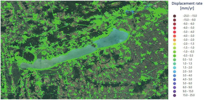
412|Kápolnainé Nagy-Göde and Török
Period. Polytech. Civ. Eng., 66(2), pp. 411–420, 2022
Fig. 1 Location of Lake Balaton in Central Europe and within Hungary
its region is an internationally popular tourist and resort Holocene trench-like depression is linked to these faults
center. Its rapidly warming shallow water, beautiful and due to the subsidence water accumulated in the lake.
mountainous and wine region of the north and flat resort The dry winds of the ice age accumulated loess in places.
towns of the south is attractive to many. Coastal slopes The coastal zone of Lake Balaton was either formed by
along the lake are in motion, causing continuous problems wave abrasion or by the deposition of lake sediments.
in terms of the stability of these slopes. The complexity of High banks, their collapses, and slumps shaped the shores.
the problem is also linked to land use since railway lines The lake dried out several times during its history and
run through several places on the slopes of high banks was filled with water again, with significant water level
or directly on the lakeshore. Additionally, steep slopes changes. These days, the Sió Channel is the only runoff.
are also found in densely built and constantly expanding Before its construction, the water levels were typically
resort and residential areas. much higher than it is today [12].
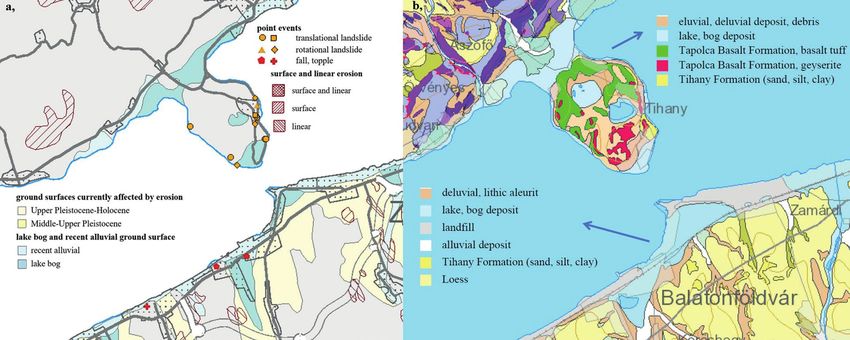
Hungary's detailed surface geological map [11] illus-
trates the lithological differences along the coast very 3 Materials and methods
spectacularly at first glance, indicating the presence of lake Various sources of information were used to gather data
sand, loess, various clays, and consolidated rocks (Fig. 2). on historical landslides. Due to the construction of rail-
The following is a brief history of Lake Balaton and way lines and recorded slope failures from the 19th century
its geological environment. The Pannonian Sea, which has (1860's) historic data on slope instability has been avail-
covered the area for millions of years during the Miocene able for the past one and a half-century. Several maps have
period, has left extremely thick sand and clay deposits. been collected showing the surroundings of Lake Balaton
The main elements of the shores are these Pannonian sed- [10, 13–14], where major landslides are marked, indicating
iments. The higher lakeside banks are now formed within the year of the landslide events and their locations (Fig. 3(a)).
these sediments, often forming a plateau. The hinterland The Mining and Geological Survey of Hungary (MBFSZ)
provided the sediments that filled the rapidly subsiding started its cadastral work in 1972. The registration of sur-
Pannonian Basin. Besides sedimentary rocks, volcanic face movement areas throughout Hungary was examined,
rocks such as basalt and basaltic tuff mark this period and as a part of the project, the Lake Balaton area was also
linked to volcanic eruptions. These rocks are found in studied. As a result of this research, the Online Landslide
the western part of Lake Balaton in the north. Post vol- Hazard Map of Hungary was published [15], and the
canic activity was marked by geysers in the Tihany pen- National Surface Movement Cadaster of Hungary [16] also
insula, forming a protective cover on the top of soft sedi- complied. The locations of past sliding events are shown on
ments. Two faults delineate the lake basin; one is located the online map identifying 28 types of mass movements.
parallel to the northern shore and the southern one. A One example from the study area, the Tihany peninsula,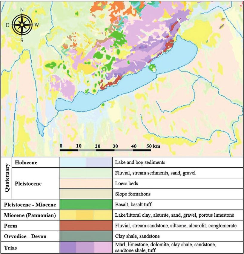
Kápolnainé Nagy-Göde and Török
                                                                                                                                             |413
                                                                                         Period. Polytech. Civ. Eng., 66(2), pp. 411–420, 2022

                                                Fig. 2 The geological map of the Lake Balaton area

 Fig. 3 a) Landslides along the coasts of Lake Balaton [10]; b) Satellite image showing unstable zones in the National Surface Movement Cadastre of
                                                                      Hungary [16]

is given in Fig. 4(a), displaying the information gathered                  and locations that are currently affected by erosion or allu-
from these maps. The points of past landslides are all                      vial surfaces are also marked. The cadaster map [16], in
accessible via a click, where an information window opens                   contrast, is a downloadable kmz file that can be opened
after the click. The following data are available in these                  on a Google Earth map (shown in Fig. 3(b)) or in geo-
information windows: movement type, settlement, peri-                       spatial software. On separate layers, one can find points
odicity, condition, built-in, possible cause, intervention.                 and polygonal zones that delimit selected surface move-
In addition, polygons denote surface and linear erosion,                    ments. These are presented on satellite images marking
414|Kápolnainé  Nagy-Göde and Török
    Period. Polytech. Civ. Eng., 66(2), pp. 411–420, 2022

         Fig. 4 Map details of the Tihany peninsula; a) Online Landslide Hazard Map of Hungary [15]; b) Surface geology of Hungary [17]

the surface motion events. The data listed for the online                    Most movements are registered in the eastern basin. The
map can also be read here, including the beginning and the                proportion of archive movements is the highest here. Most
end of the movements and the dimensions of the area. The                  of the movements (30) took place here before the 1980s.
data system currently contains more than 2000 entries.                    Between 1920 and 1940, there were ten mass movements;
The data of the movements along Lake Balaton were sum-                    between 1960 and 1980, nine mass movements occurred,
marized in tables; thus, we created a new data compila-                   while the map server recorded ten rotational landslides and
tion that was grouped and analyzed in several ways. The                   three falls (Fig. 4).
results of these analyses are presented in graphs taking                     The sedimentary series of the Tihany Formation (clay,
into account the geological conditions obtained from geo-                 sand, silt) is predominantly involved in constructing the
logical maps (Fig. 4(b)) [17]. Thus, the research methodol-               high banks of the eastern basin. These are sediments of
ogy is interpretive statistical processing of the data of the             the deltas arriving at Lake Pannon. Layers of the Tihany
maps presented in Figs. 3 and 4.                                          Formation were deposited as a series of sequences in the
                                                                          diverse palaeo-environments of the Pannonian Sea forming
4 Results and discussion                                                  deltas arriving into the lake. It consists of sediments of dif-
The main types of mass movements of raised shorelines                     ferent particle sizes but predominantly fine sand and rock
along Lake Balaton are divided into the following cate-                   flour. [18] Quaternary formations of different thicknesses
gories: historic (paleo) slides, recent slides, landslides of             settle on the layers of the Tihany Formation. The cold
slopes and falls, and additionally topplings.                             winds of the ice age formed a thin loess cover, which has
   According to the archive maps [10, 13–14], most move-                  been already eroded in many places, and elsewhere it is
ments took place in the eastern basin between 1921 and                    only present in a maximum thickness of a few meters. The
1940. Another period that was heavily affected by mass                    uppermost loess-sand sediment cover is divided by coarse,
movements was between 1961 and 1980. At that time, sev-                   gravel-debris bed embankments of the Pleistocene stream
eral landslides occurred in the eastern basin and in the                  bed. Beneath the lake-bog,-terrestrial variegated clays set-
north (Table 1).                                                          tled, while deeper layers of sand and clay alternate beneath
                                                                          mud layers with lignite settlements which play a significant
    Table 1 The data set of archive movements by area and period
                                                                          role in the horizontal flow of waters. The sliding surfaces
                    Eastern basin     North coast      South coast
                                                                          of the large slides were formed at the lake bed level of Lake
 –1900                    4                1
                                                                          Balaton; the smaller ones destroy the sandy-clay sedimen-
 1901–1920                4                3                1
                                                                          tary series and shore sections above the railway track [5].
 1921–1940                10               1
                                                                             In 1942, Aladár Vendl [19] compared the range and
 1941–1960                3                2
                                                                          landslides of the high shore of the eastern basin morpho-
 1961–1980                9                6                1
                                                                          logically with the examples of the Transylvanian Mezőség,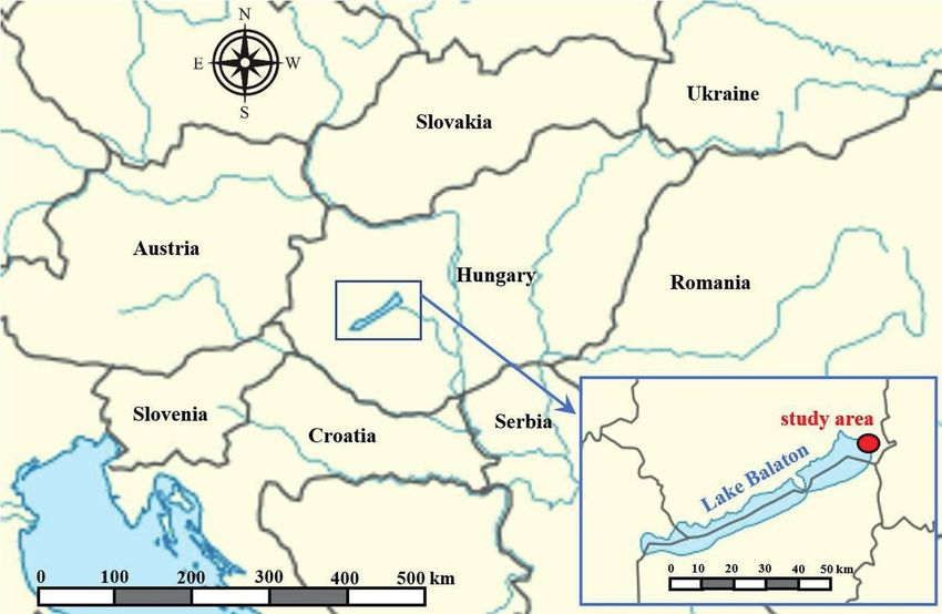
Kápolnainé Nagy-Göde and Török
                                                                                                                                              |415
                                                                                          Period. Polytech. Civ. Eng., 66(2), pp. 411–420, 2022

Italy, southern France and Central Siberia. In 1943, Lajos                      Fig. 5 shows the percentage distribution of the types of
Lóczy Jr. drew attention to the fact that the shear surface of               movements registered on the MBFSZ map server and the
the slides often extends deep below the lake bed, thus caus-                 National Surface Movement Cadaster along Lake Balaton.
ing bed rise. [19] As a result of such an event, two islands                 The differences in the geological and morphological-struc-
could have formed in front of Balatonakarattya, which can                    tural geological settings cause variations in hydrogeolog-
still be seen on the map of Ignác Müller issued in 1769, but                 ical conditions, which can explain the distinct stabilities
slope scours terminated them by the mid-1800s [19].                          of slopes [14].
    On the north coast, most of the movements (100% on                          Nearly half of the movements are rotational landslide
archive maps) are concentrated on the Tihany Peninsula,                      and slump. Deep-seated rotational motion is favored by
most of them for the period 1960–80. Digital maps record                     undrained failures and is most common in saturated soils
nine rotational landslides, seven translational landslides,                  of low permeability (clays or silts). Under special circum-
and five falls in the north (Fig. 5).                                        stances, undrained failure can occur in granular soils,
    On the northern shore, the dynamically changing high                     particularly if rapid motion is triggered by liquefaction.
shores of the Tihany Peninsula were shaped by large-scale                    In such cases, the circular sliding failure mode is short-
landslides. Here, the basalt tuffs of the Tapolca Basalt                     lived and serves as an initiating mechanism of mud-
Formation cover the sedimentary sequence of the Tihany                       flows [15]. This form of movement can occur in the nearly
Formation, which periodically stabilizes the upper edge of                   homogeneous layers and without external intervention
the high bank. Tectonic fractures and cracks mark the loca-                  if the layer material soaks for some reason and loses its
tion of the slip planes. In the north, the volcanic witness                  shear resistance. The motion does not have a predefined
buttes (Badacsony, Szigliget) were shaped by fossil slopes,                  sliding plane; it always occurs somewhere in the line of
creating dynamic, bumpy slopes. The columnar basalts of                      the highest internal stresses and the smallest resistances
witness buttes are destroyed by freezing ad falling events,                  resulting from the tare weight of the layer, thus in a place
the basalt blocks, and loose ground forms the boulder field                  appropriate to the degree of soaking and the instanta-
boundary zone on the loose Pannonian sediments [10].                         neous force conditions [22]. The subsurface flows wash
    The south bank has the most extended raised-shoreline in                 out the fine fraction of the larger particles mainly from the
length but still has the least registered moving areas. On the               sand layers, so the structure is compacted continuously or
south coast, falls/topples prevail, but rotational landslides,               periodically [23]. 33% of the movements are fall, topple,
translational landslides and creeps also occur (Fig. 5).                     collapse (bank/loess~), high bank rupture, caving, and
    Five–ten meters thick loess covers the sediments of the                  landfall. The mechanism of block toppling in the soil is
loose Tihany Formation and on the red clay cover [10].                       equal to block toppling in rock, although the low strength
Here, the Upper Pannonian sand and clay form thick lay-                      of weakly cemented or of partially saturated soil columns
ers, which is different from the eastern basin, where the                    promotes failure by basalt crushing, without the need for
Upper Pannonian is represented by thin alternating lay-                      horizontal discontinuities [23]. Behind the sandbanks of
ers of clay and sand [20]. In Fonyód, these beds are inter-                  the high shores exposed to wind, rain and sun and thus,
rupted by basalt tuff layers of the basaltic volcanism of the                vertical to subvertical cracks are formed due to shrinkage
Balaton Uplands [21].                                                        stresses. Along these, the connection between the shore

                                         (a)                                                               (b)
            Fig. 5 Proportion of landslide forms a, in the three regions of Lake shoe b, and in the entire shoreline around Lake Balaton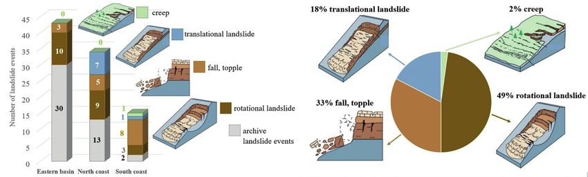
416|Kápolnainé  Nagy-Göde and Török
    Period. Polytech. Civ. Eng., 66(2), pp. 411–420, 2022

and the cracked soil plate is lost; hence, the full weight                 as diversion of water or modification of water pressure
of the cracked part can only rest on its floor. When the                   (hydrostatic or pore water pressure). When traversing the
floor can no longer withstand the pressure, the plate will                 high shores, trees with curved trunks in several places
collapse. This can occur even at low column heights if                     show signs of the slow movement.
the base of the plate soaks and loses its strength [15]. Soil                 The factors affecting changes in cliff geometry include
humps with collapse hazards also form above the break-                     wave action, frost action, seepage effects, sheet wash, and
ing front of previous slides [10]. The presence of transla-                weathering [2]. The abrasion risk of the high shores of
tional landslides is below 20% when the upper layers start                 Lake Balaton has largely disappeared with the construc-
to move along a given layer, most often at the boundary of                 tion of coastal protection works and the regulation of the
a layer of sand and clay or along with thin aquiferous sand                water level of the lake [20].
lenses in clay layers [15]. The remaining 2% of the move-                     As can see in Fig. 6, most of the previous movements
ments are creeping. It is an extremely slow movement of                    were caused by soaking. Soaking is responsible for almost
the topsoil layers on a slope (typically less than 1 m thick)              half of the translational landslides, but one-third of fall/
and results from climate-driven cyclical volume changes                    topple and nearly one-quarter of rotational landslides also
(wetting and drying, frost heave) [24].                                    caused by soaking, proving the stability-reducing effect
    Cruden and Varnes [25] divided the landslide causes                    of water.
into four major categories: nine geological causes, nine                      Slope instability events, including landslides and ero-
morphological causes, nine physical causes and eight                       sion, can be triggered by changing rainfall patterns, water
man-made (called human by USGS [26]). The USGS clas-                       level increases, and land-use patterns, such as deforesta-
sification is very similar to this; however, it mentions                   tion and desertification. All these processes increase the
only a few of the physical causes of weathering, which is                  risk of stability of slopes that have been stable for long
not a separate category for them. Kézdi [27] divides the                   periods. While the risk can be minimized by accounting
effects on the stability of slopes into three groups: physi-               for these changes when designing new artificial slopes,
cal effects of atmospherics, other natural effects, and arti-              natural and existing slopes are at higher risk of instability
ficial interventions. Water has a significant triggering role              in a changing climate [28].
in all categories, reducing the stability of the slope: sur-                  The soaking and sliding of the slope depending on the
face water, infiltrating precipitation groundwater, karstic                hydrogeological conditions [22]. The cause of the collapses
water or springs. Besides natural processes, human inter-                  at the shores of Lake Balaton is triggered by water infil-
ventions can also cause changes in the water system, such                  tration in the mountainous areas, as was already stated

                                              Fig. 6 Type of movements and the causes of landslides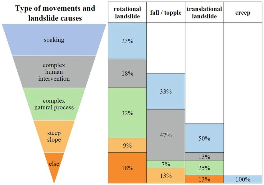
Kápolnainé Nagy-Göde and Török
                                                                                                                                      |417
                                                                                  Period. Polytech. Civ. Eng., 66(2), pp. 411–420, 2022

hundred years ago by Toborffy [29]. Later, Juhász [30] found             The data on the landslide hazard map and National
a strong correlation between rainy periods and the occur-             Surface Movement Cadaster show that more than half of
rence of landslide events. According to Franconi et al. [8]           the registered landslide hazard area of shorelines is still
the primary factors in the triggering of mass movements               in motion (Fig. 7). The recorded active slidings have 53%
at coastal areas are the above-average amount of precipi-             in the built-up area and 65% in the non-built-up area. The
tation, the extreme rains, the increased level of groundwa-           shores at rest, partially or entirely exempted, represent 41%
ter resulting from infiltration, the formation of subsurface          in built-up and 21% in the non-built-up area. There are 6%
leakage paths, the modified flow conditions, and the replen-          and 14% of areas where there are no protective measures or
ishment of the subsurface storage system. In our case, at the         their conditions are unknown, at built-up and non-built-up
shorelines of Lake Balaton, the waters that do not appear             areas, respectively (Fig. 7). At these sites, the landslide risk
on the surface as springs are the most dangerous triggers             is unknown but could be high.
of landslides [19]. In this case, the sandy soils soaked with            On the Ground motion map of Hungary [33] the lake is
water moisten the clay soils and makes these slippery thus,           contoured with a relatively stable zone in slow motion with
the slope above moves slowly downward. Due to disturbed               displacement rates of 1–1.5 mm/year. This color-coded
soil layers/stratification (mainly in the debris slopes of pre-       ground motion velocity map of satellite radar points shows
vious movements), there are sealed suitable aquifers such             the velocity estimates for more than 14 million point tar-
as sand and silty sand lenses in which water may be under             gets throughout Hungary (Fig. 8).
pressure. Thus, when the groundwater level rises, the shear              However, surface movements moved hundreds of cubic
resistance decreases, and a slip occurs [31].                         meters of soil mass in recent years near Lake Balaton. The
   Nearly half of the falls/topples at Lake Balaton is due            best-known examples are from the Balatonakarattya. In
to human interventions. Human activity (railway construc-
tion, etc.) changed the previous dynamic equilibrium con-
ditions and led to a new surface morphology [10]. However,
the impact of human activities is often favorable; for exam-
ple, the construction of coastal erosion control structures
such as rip-rap walls, rock armors or coastal roads with
foundations eliminated abrasion. Deep foundations and the
removal of soil masses, rearrangement of the terrain also
increase the slope stability [32].
   Rotational landslides are mainly caused by a complex
natural process, as explained in the description of the
forms of movement, but the water is also an important
influencing parameter of these complex processes. Steep
                                                                        Fig. 7 Hazardous areas in built-up and non-built-up areas and their
slope morphology also has a high risk of sliding.                                                  conditions

                                   Fig. 8 Ground motion map of Hungary by Geo-Sentinel [33] (detail)
418|Kápolnainé  Nagy-Göde and Török
    Period. Polytech. Civ. Eng., 66(2), pp. 411–420, 2022

May 2010, the railway track slipped along a 70 meter-wide
zone, and the railway track collapsed, and a debris slope was
formed. In March 2011, a 100-meter-long slip occurred in
the remediation piles and injections were applied. In 2017,
200–300 m3 of soil slipped due to irregular rainwater drain-
age. Based on these activities, the relative stability may be
exaggerated. The velocities at each point were calculated
from the historical data of the movements (2014–2021).
Based on this data set - an average of 100 different times
over a time interval of nearly six years -, slow movements
                                                                Fig. 9 Number of registered movements, length of registered shorelines
can also be interpreted since the measurements are less
                                                                                         along Lake Balaton
frequent than 20 days. Rapid and catastrophic landslides
affecting large areas can happen in moments damaging            Table 2 Summary table of high bank movements, shoreline length and
roads and railways. However, in most cases, slow move-                 moving areas (the maximum values are marked in bold)
ments are observed, but this does not mean that the slope                        number of registered      shoreline       moving
is stable since motion can be accelerated, and any mecha-                           movements             length (m)      areas (%)

nism can trigger rapid landslides even in these slow-moving      Eastern basin           43                9150 m           62%

areas, without any previous signs of acceleration.               North coast             34                5450 m           59%

   Similar features were observed at other lithologies such      South coast              16               11530 m          46%

as marls [34] and flysch [35]. The recording of such dis-
placements of soft rock slopes and cliff faces are possible     Balaton is the rotational landslide. These are the most com-
by using remote sensing techniques such as terrestrial laser    mon on the north and east coasts, while falls and toppling
scanner TLS [36, 37] or unmanned aerial vehicles (UAV)          prevailed in the south. The movements are mainly caused
[6, 38–40].                                                     by soaking. It can be linked to several mechanisms, such
   Fig. 9 displays all the movements recorded so far, while     as the rainy season, high lake water level, seepage of sub-
the shoreline lengths are from the summary table of the         surface waters, pipeline failure. Additionally, where there
high shores of Lake Balaton [41–42].                            are no coast protective structures, wave action erodes the
   The eastern basin is where the most collapses were gen-      coasts and triggers landslides. Human interventions, such
erated, while the total length of raised shorelines is the      as cutting slopes or building on the top of high banks, can
longest on the south coast. Many mass movements are             also cause large-scale mass movements. Fast mass move-
concentrated on the Tihany Peninsula on the north shore         ments are more characteristic (it has happened several
(Table 2).                                                      times in recent years), but slow movements are also com-
                                                                mon and can be accelerated. Field monitoring systems are
5 Conclusions                                                   essential in identifying landslide risk areas, and the avail-
A series of earlier mass movements have shaped the mor-         able techniques such as inclinometers can detect sliding
phology of the high shores of Lake Balaton, and those are       areas even if the motion is very slow. Movements endan-
also landslide hazard areas. Most of them are still in peri-    ger railway lines, roads and recreation areas; therefore,
odic motion. The highest proportion of recorded landslides      technical control is essential.
are in the eastern basin. While the longest shoreline is on
the south, most movements occur in the eastern basin and        Acknowledgement
the Tihany Peninsula since the shores rise higher. Their        The research reported in this paper has been supported by
geological conditions make this more prone to landslides.       the National Research Development and Innovation Office
The most typical landslide form of shores along Lake            of Hungary (Grant No. TKP2020 BME-IKA-VIZ)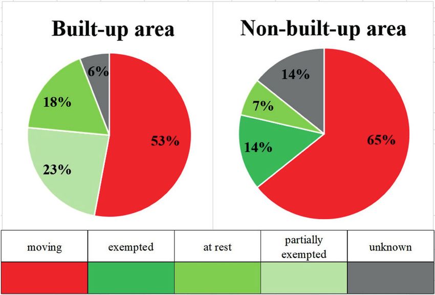
Kápolnainé Nagy-Göde and Török
                                                                                          Period. Polytech. Civ. Eng., 66(2), pp. 411–420, 2022|419

References
[1]  Barlow, J., Gilham, J., Ibarra Cofrã, I. "Kinematic Analysis of Sea     [13] Fodor, T., Kleb, B. "Magyarország mérnökgeológiai áttekintése"
     Cliff Stability Using UAV Photogrammetry", International Journal             (Engineering geological overview of Hungary), [pdf] Magyar
     of Remote Sensing, 38(8–10), pp. 2464–2479, 2017.                            Állami Földtani Intézet, Budapest, Hungary, 1986. (in Hungarian)
     https://doi.org/10.1080/01431161.2016.1275061                                Available at: http://mek.oszk.hu/19000/19071/19071.pdf
[2] Edil, T. B. "Erosion of Coastal Slopes and Landslide", presented at      [14] Horváth, Zs. "Engineering geological evolution of the danger sur-
     Geo-Congress 2013, San Diego, CA, USA, March, 3–7, 2013.                     face movement on the raised shorelines along lake Balaton", In:
     https://doi.org/10.1061/9780784412787.133                                    Pécsi, M. (ed.) Quaternary Studies in Hungary, INQUA Hungarian
[3] Edil, T. B., Vallejo, L. E. "Mechanics of coastal landslides and the          National Committee, Budapest, 1982, pp. 245–253. [online]
     influence of slope parameters", Engineering Geology, 16(1–2), pp.            Available at: http://real-eod.mtak.hu/id/eprint/4503
     83–96, 1980.                                                            [15] Magyar Bányászati és Földtani Szolgálat "Magyarország mozgás-
     https://doi.org/10.1016/0013-7952(80)90009-5                                 veszélyes területei" (Areas of danger of movement in Hungary),
[4] Bögöly, Gy., Léber, T., Rozgonyi-Boissinot, N., Vásárhelyi, B.                1:5000 000, [online] Available at: https://map.mbfsz.gov.hu/FDT_
     "Sziklarézsűk vizsgálata – elmélet és gyakorlat" (Investigation of           veszely_orszag/
     Rock Slopes – Theory and Practice), Útügyi Műszaki Füzetek 1,           [16] MBFSZ "Országos Felszínmozgás Kataszter" (National Surface
     MAÚT, Budapest, Hungary, 2021. (in Hungarian)                                Movement Cadastre), Magyar Bányászati és Földtani Szolgálat
[5] Catani, F., Tofani, V., Lagomarsino, D. "Spatial patterns of landslide        Budapest, Hungary, [online] Available at: https://mbfsz.gov.hu/
     dimension: A tool for magnitude mapping", Geomorphology, 273,                hatosagi-ugyeknyilvantartasok/orszagos-felszinmozgas-kataszter
     pp. 361–373, 2016.                                                      [17] Magyar Bányászati és Földtani Szolgálat "Magyarország felszíni
     https://doi.org/10.1016/j.geomorph.2016.08.032                               földtana, Budapest" (Surface geology of Hungary, Budapest),
[6] Giordan, D., Adams, M. S., Aicardi, I., Alicandro, M., Allasia, P.,           1:5000 000, [online] Available at: https://map.mbfsz.gov.hu/fdt100/
     Baldo, M., De Berardinis, P., Dominici, D., Godone, D., Hobbs, P.,      [18] Sztanó, O., Magyar, I., Szónoky, M., Lantos, M., Müller, P., Lenkey,
     …, Troilo, F. "The use of unmanned aerial vehicles (UAVs) for engi-          L., Katona, L., Csillag, G. "A Tihanyi Formáció a Balaton környékén:
     neering geology applications", Bulletin of Engineering Geology and           típusszelvény, képződési körülmények, rétegtani jellemzés" (Tihany
     the Environment, 79, pp. 3437–3481, 2020.                                    Formation in the surroundings of Lake Balaton: type locality, dep-
     https://doi.org/10.1007/s10064-020-01766-2                                   ositional setting and stratigraphy), Földtani Közlöny, 143(1), pp.
[7] Utili, S., Crosta, G. B. "Analysis Tools for Mass Movement                    73–98, 2013. (in Hungarian) [online] Available at: https://ojs.mtak.
     Assessment", In: Shroder, J. F., Davies, T. (eds.) Landslide Hazards,        hu/index.php/foldtanikozlony/article/view/2319
     Risks and Disasters, Elsevier, Amsterdam, Netherlands, 2015, pp.        [19] Domján, J., Pappfalvy, F. "A balatonfűzfői magaspart talajmechan-
     441–465.                                                                     ikai vizsgálata" (Soil mechanics study of the Balatonfűzfő high bank),
     https://doi.org/10.1016/B978-0-12-396452-6.00013-6                           Hidrológiai Közlöny, 33(9–10), pp. 389–395, 1953. (in Hungarian)
[8] Franconi, M., Coggan, J. S., Eyre, M., Staed, D. "A combined field/           Available at: https://library.hungaricana.hu/hu/view/Hidrologiai
     remote sensing approach for characterizing landslide risk in coastal         Kozlony_1953/?pg=0&layout=s
     areas", International Journal of Applied Earth Observation and          [20] Horváth, Zs. "A balatoni magaspartok összehasonlító mérnökgeoló-
     Geoinformation, 67, pp. 79–95, 2018.                                         giai értékelése" (Comparative engineering geological assessment of
     https://doi.org/10.1016/j.jag.2017.12.016                                    the high shores of Lake Balaton), [pdf] Mérnökgeológiai Szemle,
[9] Jabeyedoff, M., Carrea, D., Derron, M.-H., Oppikofer, T., Penna, I.           33, pp. 125–143, 1984. (in Hungarian) Available at: https://epa.
     M., Rudaz, B. "A review of methods used to estimate initial land-            oszk.hu/03200/03208/00033/pdf/EPA03208_mernokgeologiai_
     slide failure surface depths and volumes", Engineering Geology,              szemle_33_1984_125-143.pdf
     267, Article number: 105478, 2020.                                      [21] Horváth, Zs., Scheuer, Gy. "A balatonföldvári és fonyódi magas-
     https://doi.org/10.1016/j.enggeo.2020.105478                                 partok állékonyságának mérnökgeológiai vizsgálata" (Engineering
[10] Juhász, Á. "Településeket, létesítményeket veszélyeztető tömeg-              geological study of the stability of the high shores of Balatonföldvár
     mozgások a balatoni magaspartok mentén" (Mass movements                      and Fonyód), [pdf] Földtani Közlöny, 105, pp. 335–343, 1975. (in
     endangering human settlements and structures along the high                  Hungarian) Available at: https://epa.oszk.hu/01600/01635/00211/
     bluff flanking Lake Balaton), [pdf] In: Horváth, G., Papp, S. (eds.)         pdf/EPA01635_foldtani_kozlony_1975_105_3_335-343.pdf
     Földrajzi közlemények, 128, Magyar Földrajzi Társaság, Budapest,        [22] Galli, L. "A dunai és balatoni magaspartok állékonyságának törvé-
     Hungary, 2004, pp. 19–30. (in Hungarian) Available at: http://real-j.        nyszerűségei" (The regularities of the stability of the high banks of
     mtak.hu/10126/1/FoldrajziKozlemenyek_2004.pdf                                the Danube and Lake Balaton), Hidrológiai Közlöny, 32(1–2), pp.
[11] Magyar Bányászati és Földtani Szolgálat "Magyarország felszíni               409–416, 1952. (in Hungarian) [online] Available at: https://library.
     földtana, Balaton" (Surface geology of Hungary, Lake Balaton),               hungaricana.hu/hu/view/HidrologiaiKozlony_1952
     1:5000 000, [online] Available at: https://map.mbfsz.gov.hu/fdt500/     [23] Lóczy, L. "A Balaton környékének geológiai képződményei"
[12] Cholnoky, J. "Balaton" (Lake Balaton), [pdf] Franklin, Budapest,             (Geological formations around Lake Balaton), In: A Balaton tudo-
     Hungary, 1936. (in Hungarian) Available at: http://mek.oszk.hu/              mányos tanulmányozásának eredményei 1.1., Magyar Földrajzi
     00500/00574/00574.pdf                                                        Társaság Balaton-Bizottsága, Budapest, Hungary, 1913. (in
                                                                                  Hungarian) [online] Available at: https://library.hungaricana.hu/hu/
                                                                                  view/SZAK_BAKO_BalatonTudTanEredm_01/?pg=0&layout=s
420|Kápolnainé Nagy-Göde and Török
Period. Polytech. Civ. Eng., 66(2), pp. 411–420, 2022
[24] Hungr, O., Leroueil, S., Picarelli, L. "The Varnes classification of [35] Živec, T., Anžur, A., Verbovšek, T. "Determination of rock type and
landslide types, an update", Landslides, 11(2), pp. 167-194, 2014. moisture content in flysch using TLS intensity in the Elerji quarry
https://doi.org/10.1007/s10346-013-0436-y (south-west Slovenia)", Bulletin of Engineering Geology and the
[25] Cruden, D. M., Varnes, D. J. "Landslide Types and Processes", Environment,78, pp. 1631–1643, 2019.
Transportation Research Board, U.S. National Academy of Sciences, https://doi.org/10.1007/s10064-018-1245-2
Washington, DC, USA, Special Report 247, pp. 36–75, 1996. [36] Kordić, B., Lužar-Oberiter, B., Pikelj, K., Matoš, B., Vlastelica, G.
[26] USGS "Landslide Types and Processes", U.S. Geological Survey, "Integration of Terrestrial Laser Scanning and UAS Photogrammetry
Reston, VI, USA, 2006. [online] Available at: https://pubs.usgs.gov/ in Geological Studies: Examples from Croatia", Periodica
fs/2004/3072/ Polytechnica Civil Engineering, 63(4), pp. 989–1003, 2019.
[27] Kézdi, Á. "Talajmechanika I." (Soil mechanics I.), Tankönyvkiadó, https://doi.org/10.3311/PPci.14499
Budapest, Hungary, 1960. (in Hungarian) [37] Mazzanti, P., Schilirò, L., Martino, S., Antonielli, B., Brizi,
[28] Mickovski, S. B., Santos, O., Ingunza, P. M. D., Bressani, L. "Coastal E., Brunetti, A., Margottini, C., Scarascia Mugnozza, G. "The
slope instability in contrasting geo-environmental conditions", In: Contribution of Terrestrial Laser Scanning to the Analysis of Cliff
Proceedings of the XVI ECSMGE Geotechnical Engineering for Slope Stability in Sugano (Central Italy)", Remote Sensing, 10(9),
Infrastructure and Development, Edinburgh, Scotland, 2015, pp. Article number: 1475, 2018.
1801–1806. https://doi.org/10.3390/rs10091475
https://doi.org/10.1680/ecsmge.60678 [38] Giordan, D., Hayakawa, Y., Nex, F., Remondino, F., Tarolli, P.
[29] Toborffy, G. "A balatoni partrogyások sztatikai és hidrológiai "Review article: the use of remotely piloted aircraft systems
viszonyai", (Static and hydrological conditions of the shores of (RPASs) for natural hazards monitoring and management", Natural
Lake Balaton.), [pdf] In: A Magyar Állami Földtani Intézet évi Hazards and Earth System Sciences, 18, pp. 1079–1096, 2018.
jelentése (1917–19.), Magyar Állami Földtani Intézet, Budapest, https://doi.org/10.5194/nhess-18-1079-2018
Hungary, 1921, pp. 162–169. (in Hungarian) Available at: http:// [39] Török, Á., Barsi, Á., Bögöly, G., Lovas, T., Somogyi, Á., Görög,
epa.oszk.hu/02900/02934/00079/pdf/EPA02934_mafi_evi_ P. "Slope stability and rockfall assessment of volcanic tuffs using
jel_1917_19_162-169.pdf RPAS with 2-D FEM slope modelling", Natural Hazards and Earth
[30] Juhász, Á. "A klimatikus hatások szerepe a magaspartok fejlődésé- System Sciences, 18, pp. 583–597, 2018.
ben" (Static and hydrological conditions of the shores of Lake https://doi.org/10.5194/nhess-18-583-2018
Balaton), [pdf] Földtani Kutatás, 36(3), pp. 14–19, 1999. (in [40] Mancini, F., Dubbini, M., Gattelli, M., Stecchi, F., Fabbri, S.,
Hungarian) Available at: http://epa.oszk.hu/02700/02732/00141/pdf/ Gabbianelli, G. "Using Unmanned Aerial Vehicles (UAV) for High-
EPA02732_foldtani_kutatas_36_3_14-19.pdf Resolution Reconstruction of Topography: The Structure from
[31] Kézdi, Á. "A Balaton északkeleti peremén bekövetkező mozgások Motion Approach on Coastal Environments", Remote Sensing,
vizsgálata" (Movements on the northeastern edge of Lake Balaton 5(12), pp. 6880–6898, 2013.
examination ), Hidrológiai Közlöny, 32(5–6), pp. 168–177, 1952 (in https://doi.org/10.3390/rs5126880
Hungarian) [online] Available at: https://library.hungaricana.hu/en/ [41] Kenesei, J., Marokházi, G., Nagy, J. "Mozgásveszélyes Duna-menti
view/HidrologiaiKozlony_1952/?query=SZO&pg=177&layout=s és Balaton parti magaspartok veszélyelháritási munkáinak tanul-
[32] Scheuer, Gy. "A tihanyi kopaszhegyi csuszamlás mérnökgeológiai mányterve" (Study plan of emergency works for landslide hazard
vizsgálata" (Engineering geological study of the Kopaszhegy land- areas along the Danube and Lake Balaton), Kézirat, p. 71 , 2005. (in
slide in Tihany), Mérnökgeológiai Szemle, 189, pp. 77–91, 1977. (in Hungarian)
Hungarian) [42] Balogh, J., Jakab, G., Prodán, T., Kis, É., Szalai, Z., Szeberényi, J.,
[33] Grenerczy, Gy., Farkas, P., Frey, S. "Ground motion map of Hungary" Varga, Gy., Viczián,. I. "Mérnökgeomorfológiai kutatások az omlás-
Geo-Senitel, Budapest, Hungary, 2021. és csuszamlásveszélyes dunai és balatoni magaspartok partfal-re-
https://doi.org/10.5281/zenodo.4625653 habilitációjában", (Engineering geomorphological research in the
[34] Vlastelica, G., Miščević, P., Štambuk Cvitanović, N. "Durability shoreline rehabilitation of the dangerous banks of the Danube and
of soft rocks in Eocene flysch formation (Dalmatia, Croatia)", Lake Balaton), In: VII. Magyar Földrajzi Konferencia Kiadványa,
Engineering Geology, 245, pp. 207–217, 2018. Miskolc, Hungary, 2014, pp. 60–70. (in Hungarian) [online]
https://doi.org/10.1016/j.enggeo.2018.08.015 Available at: http://real.mtak.hu/id/eprint/20847You can also read