Travers-Sabine Circuit - Department of Conservation
←
→
Page content transcription
If your browser does not render page correctly, please read the page content below

NELSON/TASMAN

Travers–Sabine
Circuit
Nelson Lakes National Park
Contents
Introduction                        3

Biosecurity                         3

Landform                            4

Vegetation                          4    Nelson Lakes. Photo: Shellie Evans

Animals                             5

History                             6    Introduction
                                         The 80 km Travers–Sabine Circuit reaches deep into the
How to get there                    6    heart of the mountains of Nelson Lakes National Park.
                                         Tranquil beech forests, fields of waving tussocks, 2000 m
Accommodation                       7
                                         high mountains and clear rushing streams are highlights
Commercial transport operators      8    of the journey.
                                         The circuit requires 4–7 days to complete and involves
Huts and campsites                  9    a crossing of Poukirikiri / Travers Saddle, an alpine pass
                                         subject to freezing conditions at any time of the year.
Travers–Sabine
                                         Most of the track is classified as a tramping track. It is well
Circuit map                         12   marked and although most rivers and streams are bridged,
                                         after heavy rain there are a number of streams that may not
Walking the track                   14   be safe to cross. Sturdy boots and a good standard of fitness
                                         are recommended, and warm, waterproof clothing is essential.
Track profile                       15
                                         Pricing varies according to the season. Refer to
Completing the circuit –                 www.doc.govt.nz or call Rotoiti / Nelson Lakes Visitor
Sabine Hut to St Arnaud             18   Centre on 03 521 1806.

Side trips                          19
                                         Biosecurity
Plan and prepare                    20   The invasive microscopic algae didymo and
                                         lake snow diatom Lindavia are significant
Safety information                  21   threats to freshwater in the park.
                                         Please Check Clean Dry all clothing,
Raoulia eximia (vegetable sheep).        footwear and equipment before
Photo: Markus Baumann                    arriving. Unfortunately, Lakes Rotoiti
                                         and Rotoroa have been infected with
                                         lake snow. Any clothing or equipment that comes into
                                         contact with water in Rotoiti or Rotoroa can spread lake
                                         snow to other tarns or lakes. The best way to treat gear in
                                         the backcountry is to make sure it is thoroughly dry for
                                         48 hours, or soak in 10% detergent solution for 10 minutes.

2                                                                                                     3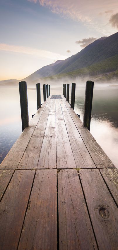
Landform                                                        Animals
The mountains have been thrust up by continental                The park land encompassed by the Travers-Sabine Circuit
collision along the Alpine Fault, which crosses the track       is subject to landscape-scale predator control aimed at
in places between Sabine Hut and Lake Rotoiti.                  stoats, rats, possums and feral cats. A poison-based aerial
Extensive glaciation, erosion and weathering have left          control is usually timed around beech-seed masting events,
a characteristic landscape of steep valley sides, scree         which can occur every 3 to 7 years.
slopes, sharp ‘arête’ ridges and many tarn‑filled basins.       The Rotoiti Nature Recovery Project is a long-term, multi-
The forested valleys once cradled glaciers, which               pest control programme that maintains reduced predator
excavated the hollows now filled by the waters of Lakes         numbers along the eastern side of Lake Rotoiti and
Rotoiti and Rotoroa.                                            effectively protects kākā, roroa (great spotted kiwi) and kea
                                                                during the time intervals between aerial predator control
                                                                events. The Friends of Rotoiti also maintain a trapline for
Vegetation                                                      stoats in the Sabine and the Travers valleys.
The park’s forests are dominated by beech trees. Along the      Roroa can be heard at night at Rotoiti (but are hardly ever
valley floors, red and silver beech prevail; on the higher      seen). The raucous call of kākā is often heard, and visitors
slopes where the soil is thinner, the small-leaved mountain     enjoy the friendly toutouwai / South Island robin and
beech takes over. A wide diversity of small trees and shrubs    ngirungiru / tomtit that will venture close. Korimako /
make up the rest of the forest, including red-flowered          bellbirds, tūī and pīwakawaka are common and noisy in
southern rātā, and yellow-flowered kōwhai around the            the forest, and the tiny tītipounamu / rifleman can often
lake edges. Altitude is the main driver of forest type and      be heard before it is seen. Pekapeka / long-tailed bats live
diversity in the park.                                          in the lower altitude forests, especially near Lake Rotoroa,
Ferns, mosses, and lichens proliferate on the forest            but as they are nocturnal it is very hard to spot them.
floor and on tree trunks, where the light is subdued.                    Kea were reduced to extremely low numbers from
At the bushline, forest gives way to shrubland, where                    1990 to 2010 and the population is now rising in
white-flowered hebe, wharariki / mountain flax, rust-red                 response to careful predator management.
Dracophyllum, and the spiky flower heads of speargrass          They can often be seen and heard in the alpine areas and
plants pepper the landscape. Beyond the shrubland,              will sometimes be keen to investigate huts and areas where
tussocks soften the harsh texture of broken rock.               people congregate. Please, never feed the kea, and keep
Throughout the alpine tops in summer, yellow buttercups,        your belongings contained! Human food is bad for them.
white mountain daisies and many species of small, specialised   Whio / blue duck are sometimes seen in the upper Sabine,
plants flourish in the brief growing season. Most alpine        and extremely rare geckos are present in some alpine areas
herbs are very slow growing and sensitive to disturbance        of the park. If you spot a gecko in an alpine environment,
like trampling, so please keep to the marked routes.            DOC staff would love to hear about it.

4                                                               Male tītipounamu / rifleman. Photo: Leon Berard            5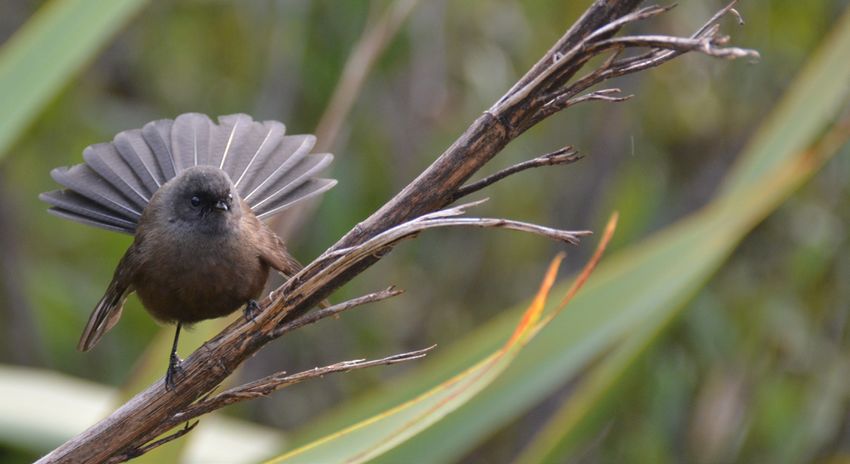
History                                                        Accommodation
Legend tells the story of Rākaihautū, chief and explorer,      On the Travers–Sabine Circuit, Hopeless, Cupola and
who came to Aotearoa and travelled with his people             Coldwater huts are standard huts. All other huts on the
to the great mountains. With his kō (digging stick),           circuit are serviced huts. Backcountry Hut Passes or
Rākaihautū dug enormous holes that filled with water.          Backcountry Hut Tickets are required to stay in all huts.
He then placed kai (food) in the lakes that had formed for     Seasonal pricing may apply – refer to the DOC website.
those who followed him. The kai – eel, freshwater mussels      Angelus Hut and Bushline Hut operate on a booking
and waterfowl – was important for Māori travelling the         system all year round. Please book online at
pounamu (greenstone) trails to and from the West Coast.        www.doc.govt.nz.
The lakes, Rotoiti (little lake) and Rotoroa (long lake),
remain today.                                                  Lake Rotoiti has a serviced campsite open all year at
                                                               Kerr Bay. A standard campsite is open during the peak
From their arrival in the 1840s, Europeans rapidly occupied    summer months at West Bay. Both campsites require
open land close to Rotoiti for grazing sheep. By 1900,         bookings at all times.
people were holidaying on the shores of the lake, and in the
1920s a fishing lodge was built at Rotoroa.                    There is a range of accommodation options in
                                                               St Arnaud and Rotoroa.
Soon cottages were being built at Rotoiti and people began
to explore the mountains. In 1956, the scenic values of the
mountains and lakes were recognised nationally with the        PHOTOS:
creation of the national park.                                 Left: Winter dawn at Lake Rotoiti.
                                                               Photo: Ray Salisbury hotpixels.co.nz

How to get there                                               Right: Angelus Hut on Rotomaninitua / Lake Angelus.
                                                               Photo: David Eckl
St Arnaud is easily accessible from Nelson and Blenheim.
From each location it is a 1 hr 30 min drive on good roads.
Contact information is available at the Rotoiti/Nelson
Lakes Visitor Centre.

Public transport
There are limited transport options to and from the area.
Water taxis operate all year round on both lakes.
More information is available at the Rotoiti / Nelson Lakes
Visitor Centre.

6                                                                                                                          7
Coldwater jetty. Photo: Crystal Brindle
                                                           Huts and campsites

                                                           Hut and campsite fees
                                                           Seasonal pricing applies to hut tickets. The Backcountry
                                                           Hut Pass may not be valid during the summer period.
                                                           For more information, go to www.doc.govt.nz or contact
                                                           Rotoiti / Nelson Lakes Visitor Centre, by phone 03 521 1806
                                                           or email nelsonlakesvc@doc.govt.nz.

                                                           Hut categories
                                                                 Serviced huts have mattresses, a water supply,
                                                                  toilets, hand-washing facilities and wood fireplaces.
                                                                  Firewood is supplied during the higher use period
                                                                  (October–April). A warden may be present. During the
                                                                  low season, Backcountry Hut Passes or Backcountry
                                                                  Hut Tickets are required. During high season the
                                                                  Backcountry Hut Pass is not valid.
                                                           	You must book to stay at Angelus Hut and Bushline Hut.
                                                             Please refer to www.doc.govt.nz.
                                                               	Standard huts have mattresses, a water supply and
                                                                 toilets. Wood heaters are provided at huts below the
                                                                 bushline. Backcountry Hut Passes or Backcountry
                                                                 Hut Tickets are required.
                                                               	Basic huts provide very basic shelter with limited
                                                                 facilities; no charge.

                                                           Campsite categories
                                                                 Serviced campsites have a wide range of facilities
                                                                  and services. Flush toilets, tap water, kitchen/cooking
                                                                  bench, hot showers and road access for all types
                                                                  of vehicles are available. A cooker and picnic tables
                                                                  may be available.
    Commercial transport operators                               Standard campsites have a more limited range
                                                                  of facilities and services than serviced campsites.
    Please contact Rotoiti / Nelson Lakes Visitor Centre          These campsites have toilets, water supply
    for information about commercial transport and water          (tap, stream or lake) and vehicle or boat access.
    taxi operators.                                               Cold showers and a cooking shelter are available.
    PHONE: 03 521 1806                                         	Basic campsites have toilet facilities and may
    EMAIL: nelsonlakesvc@doc.govt.nz                             have a water supply.

8                                                                                                                           9
Coldwater Hut from boat deck. Photo: Shellie Evans   West Sabine Hut. Photo: DOC

     Lakehead Hut. Photo: DOC                             Sabine Hut. Photo: Gabriella Czoma

     John Tait Hut. Photo: Gabriella Czoma                Speargrass Hut. Photo: Gabriella Czoma

     Upper Travers Hut. Photo: DOC

10                                                                                                 11
!
St Arnaud
!
Travers–Sabine
!
!
State Highway Information centre
Circuit map
Sealed road Serviced hut
!
Unsealed road
!
Standard hut
Mt Robert Lake
!
!
Short walk
!
car park Rotoiti
Track categories Basic hut
!
k
Walking track ee
! !
!
Cr
Tracks are developed to different standards to Tramping track Serviced campsite ss
!
ra
cater for a variety of experiences. Choose the rg
! ! ! ! ! Route Standard campsite pea Pourangahu/ "
!
type of track that matches your skills, fitness ai/
S Mt Robert
and the experience you want – be realistic. Car park w Bushline Hut
ro
! ! ! ! !
!
Travers–Sabine o
!
!
Your safety is your responsibility. Circuit H !
E (14 bunks)
Te
DG
!
±
! !
Toilet Speargrass Hut
!
RI
!
!
(12 bunks) !
Walking track RT
!
0 1 2 3 4 5
BE
!
!
!
!
!
!
RO
Kilometres
▶ Easy to moderate walking from a few
!
!
!
!
This map is a guide only. For more information consult
!
!
minutes to a day.
!
NZTopo50 maps BR24 Kawatiri and BS24 Mount Robert
!
!
!
!
▶ Track is mostly well formed, some !
! !
Coldwater Hut
!
!
!
sections may be steep, rough or muddy. Lakehead Hut
!
E
(12 bunks)
!
!
!
(28 bunks)
!
NG
! !
▶ Suitable for people with low to
!
!
!
!
moderate fitness and abilities. Lake Rotomaninitua/
RA
!
!
!
!
Rotoroa Lake Angelus Angelus Hut
▶ Clearly signposted. Stream and river
!
! !
!
!
! (28 bunks)
AUD
!
crossings are bridged.
!
!
!
!
!
!
!
! ! !
! ! !
H ukere
▶ Walking shoes or light tramping/hiking
!
! !
S tream
RN
boots required. D'Urville Hut Sabine Hut Maniniaro/
(10 bunks) (32 bunks) " Angelus Peak
ST A
Tramping track 2075m
▶ Challenging day or multi-day
!
GE
!
!
!
tramping/hiking.
! !
!
!
N
!
▶ Track is mostly unformed with steep,
!
Hopeless Hut
S RA
rough or muddy sections. (6 bunks)
Mount Misery
▶ Suitable for people with good fitness. Hut (4 bunks)
D'
Moderate to high-level backcountry
TRAVER
r
Mt Hopeless
ve
Ur
skills and experience, including "
2278m
Ri
vi l l
navigation and survival skills, required.
ver
s
e Ri
▶ Track has markers, poles or rock
er
e Ri
cairns. Expect unbridged stream and
av
ve r
E
Sabin
Tr
river crossings.
!
NG
▶ Tramping/hiking boots required.
RA
Cupola Hut
(8 bunks) John Tait Hut
Route (27 bunks)
UD
Morgan Hut
▶ Challenging day or multi-day (10 bunks)
NA
Mt Cupola
tramping/hiking. "
AR
2260m
E
NG
▶ Track unformed and natural, rough,
ST
muddy or very steep. !
RA
! !
!
▶ Suitable for people with above-
!
West Sabine Hut !
!
(30 bunks)
A
average fitness. High-level backcountry
!
!
NG
skills and experience, including Mt Travers
!
r
ve
"
!
2338m
Ri
navigation and survival skills, required. Upper Travers Hut
!
HA
ine
(24 bunks)
!
!
b
▶ Complete self-sufficiency required.
!
!
Sa
!
East Branch Sab ine
MA
!
!
!
ch
!
! !
▶ Track has markers, poles or rock
!
!
!
!
ran
!
Poukirikiri/Travers Saddle
!
!
!
cairns. Expect unbridged stream and
st B
!
1787m Begley Hut
!
river crossings.
We
(8 bunks)
!
!
▶ Sturdy tramping/hiking boots required.
!
River
!
Mt Franklin
!
2340 m
!
Blue Lake Hut
12 13
!
"
(16 bunks)
!
Rotomairewhenua/Blue Lake © Geographx
!
!
! !
!
! !
!
!
!
!
! !
!
! !
!
Walking the track
The circuit is best walked as described below because
Track profile
Altitude (m)
crossing the Poukirikiri / Travers Saddle is easier from
1000
1200
1400
1600
1800
Travers–Sabine Circuit profile from Lakehead Hut to Mt Robert car park
400
600
800
the Travers side. Walking times are a guide only and will
vary with fitness and weather conditions. Weather and
(630 m)
Lakehead Hut
snow conditions are most favourable between October
and May, although in some years winter snow persists
Travers Track
junction
into late November on alpine passes.
4 hr 30 min
Hopeless Track
junction
St Arnaud to Lakehead Hut (28 bunks) / Coldwater Hut
(12 bunks), 3 hr
John Tait Hut
rom Kerr Bay: Beginning at the eastern end of the
F
(810 m)
Cupola Track
bay, the Lakehead Track wanders through forest,
junction
crossing several shallow streams and shingle screes.
Upper Travers Hut
Small beaches along the way offer picnicking
Poukirikiri/Travers Saddle (1787m)
3 hr
opportunities and mountain views. At the head of
(1320 m)
Lake Rotoiti, the grassy flats of the lower Travers valley
greet you. Lakehead Hut is 15 min on from the jetty.
rom West Bay: Walk up Mount Robert Road to
F
6–9 hr
where the Lakeside Track descends to the lake edge
West Sabine
Hut (670 m)
through dense mānuka and kānuka forest. Follow the
lake shore to Coldwater Hut, which is perched right
on the water’s edge. The short diversion to Whisky
Falls is worthwhile. Many trampers take a water taxi
to the head of Lake Rotoiti to start their trip.
5 hr
Lakehead Hut / Coldwater Hut to John Tait Hut
Sabine–D’Urville Track
(27 bunks), 4 hr 30 min
rom Lakehead or Coldwater huts, walk up the Travers
F
junction
River flats through forest and clearings (remnants
Sabine Hut
from the valley’s farming days). The track from (455 m)
Coldwater Hut passes the turn‑off to
Rotomaninitua / Lake Angelus. After 1 hr 30 min of
easy walking you’ll reach a swing bridge, beyond
5 hr
which the track continues on the west bank of the
Travers River. Speargrass Hut
Soon the valley narrows and walking becomes more
(1060 m)
varied, alternating between forested terraces and
grassy river flats. Mount Travers can be glimpsed as
the track nears Hopeless Creek.
3 hr
Mt Robert
car park
(880 m)
Cross the creek on a swing bridge. Soon you’ll leave
the river and notice the gradient becoming steeper.
As it eases, you’ll hear the river again. Cross a few
1000
1200
1400
1600
1800
400
600
800
small creeks and suddenly emerge to the welcome Altitude (m)
sight of John Tait Hut at the head of a small clearing.
14 15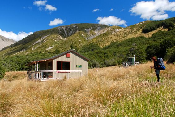
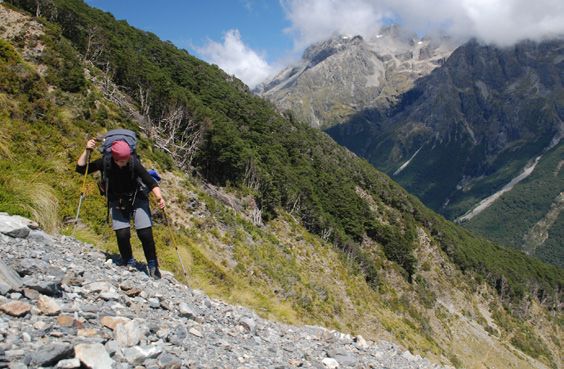
The track between John Tait Hut and Upper                      The descent from Poukirikiri / Travers Saddle into
Travers Hut. Photo: Gabriella Czoma                            Sabine valley. Photo: Kathrin and Stefan Marks

John Tait Hut to Upper Travers Hut (24 bunks), 3 hr                  up a scree slope before continuing more gently to the
       ontinue beyond John Tait Hut to Cupola Creek
      C                                                              saddle with its panoramic views. The saddle is 450 m
      chasm, from where the track climbs steeply, leaving            above the hut, about 1 hr 30 min walking.
      the river in its gorge below. A sign marks a short       	From the saddle, the descent is steep – the Sabine
      side‑track to Travers Falls, a 20 m cascade plunging       forks lie 1000 m below. The track crosses tussock and
      into a deep bowl.                                          scree, then briefly enters stunted beech forest before
	Back on the main track, the gradient soon eases.               emerging into a steep gully. Descend by zigzagging
  Cross several scree slopes, and eventually the Travers         to the valley floor, where the track begins again and
  River via a short bridge. From here, the forest is             the walking becomes easier.
  noticeably stunted and the track, although steep again,      	Ten minutes further on, a bridge crosses the deep
  offers occasional views of the looming mountains.              chasm of the East Branch Sabine River. The track
	Finally the track levels and emerges from the trees            sidles around the edge of this chasm before descending
  onto an extensive tussock‑covered flat, where Upper            into the West Branch Sabine River valley and heading
  Travers Hut nestles at the base of the east face of            upstream a short distance to West Sabine Hut.
  Mount Travers.
                                                               West Sabine Hut to Sabine Hut (32 bunks), 5 hr
Upper Travers Hut to West Sabine Hut (30 bunks),                       se the swing bridge upstream of the hut to cross
                                                                      U
6–9 hr depending on conditions                                        the west branch of the Sabine River. The track down
       oukirikiri / Travers Saddle is an alpine pass
      P                                                               the valley sidles above the river and crosses three
      requiring ice axes and crampons in winter and well              long, open flats.
      into spring. Be prepared for sudden weather changes.     	Leave the river where it enters a gorge in the lower
      The Sabine side of the saddle in particular is exposed      valley. Climb steeply, then descend again, rejoining
      to avalanches. At Upper Travers Hut, the track              the deep river at a bridge across a narrow cleft. Easy
      becomes a route marked with snow poles as far as the        walking leads to Sabine Hut, with its expansive views
      bushline on the Sabine side.                                over Lake Rotoroa. From Sabine Hut there are two ways
	Cross the Travers River near the hut and follow the             to finish the tramp: either by tramping via Speargrass
  poles through dense alpine shrubs. Leaving the                  Hut and the Speargrass valley, or taking the Rotoroa
  boulder‑strewn valley, the track steepens and zigzags           Water Taxi to Rotoroa village.

16                                                                                                                      17
Side trips
                                                                  Travers valley side creeks
                                                                         Hukere Stream: From the junction with
                                                                         the Travers Track, it is a steady, 4 hr ascent
                                                                          to Rotomaninitua / Lake Angelus and the
                                                                          lake‑filled basins of the Travers Range.
                                                                          A separate publication, Angelus Hut Tracks
                                                                          & Routes, describes the tramp to Rotomaninitua /
                                                                          Lake Angelus.
Speargrass Hut. Photo: Kathrin and Stefan Marks
                                                                         Hopeless Creek: Follow the river for 1 hr 30 min
                                                                         to Hopeless Hut (6 bunks).
Completing the circuit –                                                 The Cupola basin: 2 hr 30 min of strenuous
                                                                         climbing leads to the lofty perch of Cupola Hut
Sabine Hut to St Arnaud                                                   (8 bunks), with superb views of Mount Hopeless.

To St Arnaud via Speargrass Hut (12 bunks), 8 hr                  Rotomairewhenua / Blue Lake, 7 hr return
       ollow the track along the lake shore before climbing
      F                                                                   his is a worthwhile overnight side‑trip from
                                                                         T
      to Howard Saddle, then begin a long sidle in and out               the main circuit. Head upstream from the West
      of several small valleys and through delicate                      Branch Sabine swing bridge. After 1 hr 30 min,
      wetlands. Here you will notice the distinctively                   the valley broadens and the track passes
      conical kaikawaka, or New Zealand cedar, with its                  through forest destroyed by an avalanche
      dark foliage, stringy bark and often twisted trunk.                in 1980. Climb steeply in two stages to a high
	After about 5 hr, the track reaches a saddle, from                     basin containing Blue Lake Hut (16 bunks).
  where it descends to a clearing above Speargrass Hut.                  Rotomairewhenua / Blue Lake is thought to be
                                                                         the clearest natural freshwater lake in the world.
	Leaving Speargrass Hut, cross the bridge over                          Please respect this pristine water by refraining
  Te Horowai / Speargrass Creek and enter the forest.                    from washing or swimming in the lake.
  A well‑graded track descends to the valley floor and
  follows the river before climbing gradually for some            Rotomaninitua / Lake Angelus via Mount Cedric,
  distance to Pourangahau / Mount Robert car park,                6–9 hr depending on conditions
  overlooking Lake Rotoiti. From here, it is 1 hr 30 min
                                                                          his is a very exposed route to the Angelus
                                                                         T
  down Mount Robert Road to St Arnaud village.
                                                                         basin. The track begins behind Sabine Hut and
                                                                         climbs very steeply and steadily to the
                                                                         bushline. Poles and cairns mark the route from
                                                                         here, which eventually drops off the eastern
                                                                         side of a high ridge and descends to
                                                                         Rotomaninitua / Lake Angelus.

                                                               Rotomaninitua / Lake Angelus. Photo: David Eckl

18                                                                                                                            19
Plan and prepare Safety information
Plan, prepare and equip yourself well. Have the right gear Be prepared
and skills for the trip. For up-to-date track alerts, weather
tay safe in the outdoors by following the
S
and other safety information, go to www.doc.govt.nz/plan
Land Safety Code.
This information is also displayed on the Nelson Lakes
Visitor Centre noticeboards. ▶ Choose the right trip for you
▶ Understand the weather
Weather
Hospitable and welcoming on a fine day, Nelson Lakes ▶ Pack warm clothes and extra food
National Park and (especially) the alpine route over ▶ Share your plans and take ways to get help
Poukirikiri / Travers Saddle are prone to sudden weather ▶ Take care of yourself and each other
changes bringing freezing winds and snow at any time
of the year. Even small streams are dangerous in flood. Snow and avalanches
Winter conditions or bad weather could slow or stop your With snow on the ground, Poukirikiri / Travers
progress to or from the hut. A fall onto hard or icy snow Saddle and side trips into the alpine basins
could be lethal. Snow avalanches are possible. should only be attempted by experienced and
well‑equipped groups.
What to take
Be wary of avalanches. Avalanches occur in the
Personal locator beacons are available for hire from Nelson
park every year, normally between June and
Lakes Visitor Centre. Pack a range of equipment for warm,
cold, windy or wet conditions. You will need at least one October but sometimes as late as December.
set of clothes to walk in and another dry set to change into Most occur during winter storms or in spring/early
at night. Cotton clothing is not suitable; wool and modern summer when warmer temperatures or rain make
synthetics are better as they dry quickly and give more warmth. the snow unstable. The Travers–Sabine Circuit
has more than 20 recognised avalanche paths.
Winter visitors should carry and know how to use: an ice
axe, crampons, snow shovel, avalanche transceiver To reduce the risk of being caught in an avalanche,
and probe. do not stop between the avalanche signs. Even
if you cannot see snow from the track, there
You will need to provide your own sleeping bag, fuel, toilet
may be enough snow out of sight on the upper
paper, cooking equipment, food and utensils. Take a day's
slopes to form an avalanche that could reach
spare food in case of delay due to weather conditions.
the track. Avalanche paths are only marked on
Trip intentions the Travers–Sabine Circuit and Blue Lake Track.
Leave details of your trip (return date and time, planned Latest avalanche risk information, including
route, party members names and vehicle licence plate track and hut closures, is available from the
numbers) with a trusted contact, and don't forget to let Rotoiti / Nelson Lakes Visitor Centre. Alternatively,
them know when you return. You can also do this with check the New Zealand Avalanche Advisory at
the New Zealand Outdoor Intentions process on the www.avalanche.net.nz/region/13 or the NIWA
AdventureSmart website weather website for Nelson Lakes National Park
www.adventuresmart.org.nz/outdoors-intentions. at weather.niwa.co.nz/parks.
Remember to fill in hut books during your trip, even if
you do not stay in the hut. They can assist in search and
rescue operations, and may help save your life.
20 21Water quality Sandflies
ater supplies in the Travers and Sabine valleys are
W he presence of biting sandflies can detract from
T
generally of high quality but cannot be guaranteed. your experience at the lakes, especially during the
You may choose to boil, filter or treat drinking water. summer months. Cover up and apply a good quality
Please use toilet facilities and help keep water insect repellent to any exposed skin.
supplies clean.
Rubbish
Beware of catching or spreading norovirus (stomach o rubbish facilities are provided in the backcountry
N
bugs): good hygiene practices are essential. Always – pack out what you pack in.
clean hut surfaces after use.
No pets
Cooking
o protect wildlife, domestic animals are prohibited
T
o cooking facilities are provided in the huts.
N
in the Nelson Lakes National Park. Dog owners
All visitors should carry portable cookers and fuel.
convicted of bringing a dog into the park face a fine
Wasps of up to $800 under the National Parks Act 1980.
here are high numbers of wasps, particularly
T Drones
between January and April. Consider carrying an
rones are prohibited in the Nelson Lakes
D
antihistamine product and, if you are allergic to their
National Park.
stings, ensure you carry medication with you.
Tīrairaka pango / black fantail. Photo: Shellie Evans
Care for Aotearoa
Protect nature Be prepared
Keep your distance Stay safe in the
and don’t feed wildlife. outdoors by following
Follow any rules the Land Safety Code.
restricting dogs, fires, Choose the right
drones or vehicles. trip for you.
Understand the
weather.
Keep NZ clean
Pack warm clothes
Take all rubbish with
and extra food.
you and use toilets
Share your plans
where provided.
and take ways to
get help.
Show respect Take care of yourself
Respect others, and each other.
respect culture.
22 23Further information
Department of Conservation
Rotoiti / Nelson Lakes Visitor Centre
View Road
St Arnaud 7053
PHONE: (03) 521 1806
EMAIL: nelsonlakesvc@doc.govt.nz
Department of Conservation
Nelson Visitor Centre
Taha o te Awa / Millers Acre Centre
79 Trafalgar Street, Nelson 7010
PO Box 375, Nelson 7040
PHONE: (03) 546 9339
EMAIL: nelsonvc@doc.govt.nz
www.doc.govt.nz
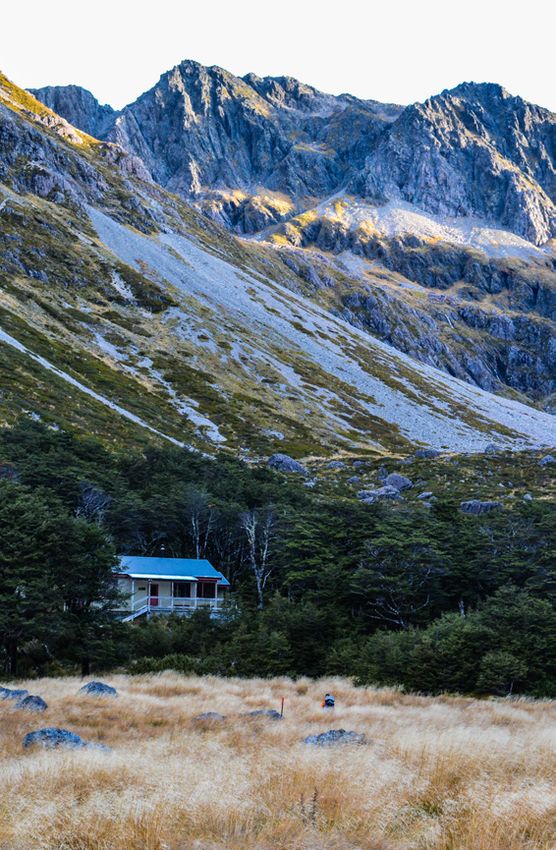
Cover photo: Upper Travers Hut.
Photo: Gabriella Czoma
Published by:
Department of Conservation
Rotoiti / Nelson Lakes
Visitor Centre
PO Box 55, St Arnaud 7053
Editing and design:
Te Rōpū Ratonga Auaha,
Te Papa Atawhai
DOC Creative Services
August 2022
This publication is produced using
paper sourced from well-managed,
renewable and legally logged forests.
R214879You can also read