TRANSLATING SCIENCE TO POLICY IN PLANNING FOR SEA-LEVEL RISE AND STORM SURGE
←
→
Page content transcription
If your browser does not render page correctly, please read the page content below
TRANSLATING SCIENCE TO POLICY
IN PLANNING FOR SEA-LEVEL RISE
AND STORM SURGE
Monroe County, Florida with a focus on Islamorada, Village of Islands

A Report by the South Florida Regional Planning Council
Funded by the Gulf of Mexico Alliance and
the National Oceanic and Atmospheric Administration
In Partnership with Monroe County and Islamorada, Village of Islands
ACKNOWLEDGEMENTS

Gulf of Mexico Alliance

Laura Bowie, Executive Director
Tracie Sempier, PhD, Regional Program Manager

South Florida Regional Planning Council

Isabel Cosio Carballo, Executive Director
Alyssa Jones Wood, Project Manager
Keren Bolter, PhD, Co-Project Manager
Vince Edwards, Data Analyst
Kathe Lerch, Administrative Assistant
Shanna Haley, Intern
Jenna Slade, Intern

Project Communities

Seth Lawless, Islamorada Village Manager
Cheryl Cioffari, Islamorada Immediate Past Director of Planning
Sheila Denoncourt, Islamorada Chief Building Official
Mary Swaney, Assistant to Islamorada Village Manager
Rhonda Haag, Monroe County Sustainability Director

This publication was funded by a National Oceanic and Atmospheric Administration (NOAA)
Cooperative Grant provided through the Gulf of Mexico Alliance.

Completed August 2018

                                                                                          2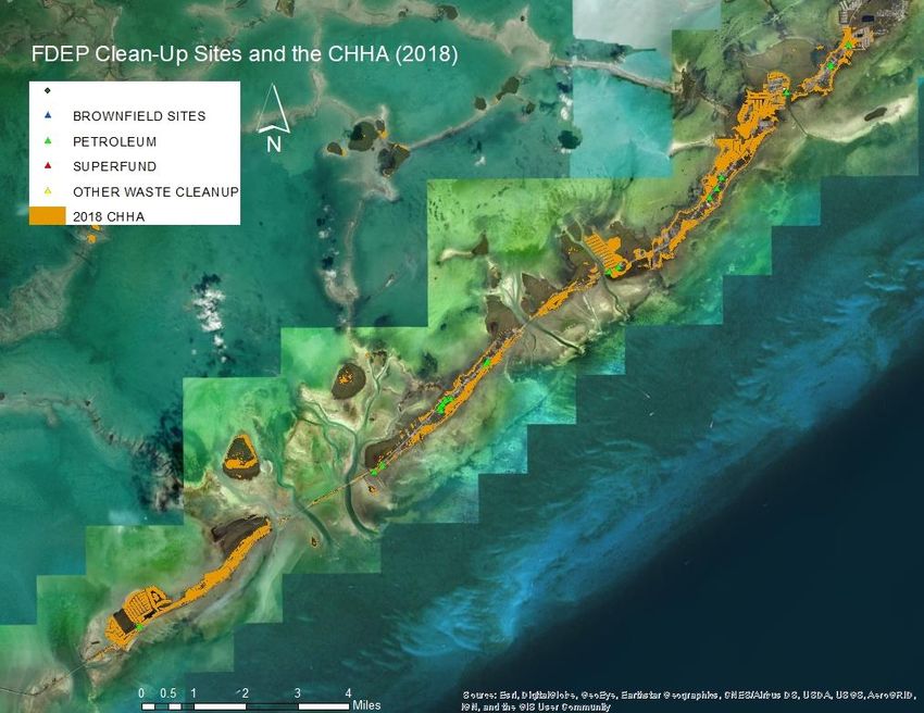
TABLE OF CONTENTS

ACKNOWLEDGEMENTS ........................................................................................................... 2
EXECUTIVE SUMMARY ............................................................................................................. 4
INTRODUCTION........................................................................................................................ 4
BACKGROUND...........................................................................................................................5

   Sea-Level Rise ........................................................................................................................ 6
   Hurricane Risk ......................................................................................................................... 7
   Purpose of the Study .............................................................................................................. 8
   Study Area ............................................................................................................................. 8
   Online Webtool for the Study ............................................................................................... 10

METHODS ................................................................................................................................ 10

   Quantitative .......................................................................................................................... 11
   Qualitative ............................................................................................................................ 12

RESULTS .................................................................................................................................. 13

   Monroe County Modeling ..................................................................................................... 13
   Islamorada Modeling............................................................................................................. 16
   Qualitative ............................................................................................................................ 17
   Site Inspections ..................................................................................................................... 19
   Social Vulnerability ............................................................................................................... 19
   Workshop .............................................................................................................................. 21

DISCUSSION ............................................................................................................................ 21
RECOMMENDATIONS ............................................................................................................. 23

   Planning and Policy ............................................................................................................... 23
   Adaptive Capacity ................................................................................................................ 26

Appendix .................................................................................................................................. 27

   A: Maps ................................................................................................................................. 27

                                                                                                                                             3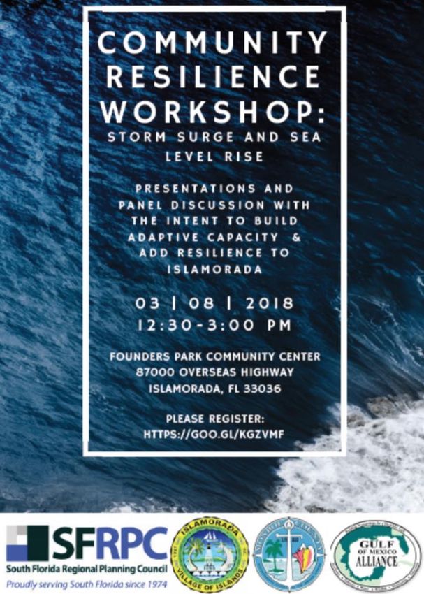
EXECUTIVE SUMMARY
Monroe County, colloquially referred to as “The Florida Keys” or “The Keys” is a chain of islands
between the Atlantic Ocean and the Gulf of Mexico is located at the southern tip of Florida. This
community is characterized by heavy scenic tourism, deeply rooted locals, and the essence of
the Caribbean. This document provides a summary of a vulnerability assessment done to
investigate the compound risk of sea-level rise and Hurricane Category 1 storm surge in Monroe
County, specifically Islamorada, Village of Islands (Islamorada/Village). Additionally, this
document provides a list of recommended adaptation actions for the Village of Islamorada to
reduce risk and loss from flooding.

Throughout the course of this study,
the strongest hurricane ever recorded
in the Atlantic brewed to the size of
the state and made landfall in the
United States as a Category 3
hurricane in Cudjoe Key in Monroe
County. At the point of this report’s
publication, county-wide hurricane
recovery is still underway. A tropical                          Hurricane Irma
archipelago with no barrier islands,
Monroe     County     is   consistently
vulnerable to natural hazards such as tidal flooding, hurricanes, tropical storms/depressions, and
more recently- sea-level rise and other implications of global climate change.

INTRODUCTION
This study investigates the intersection of accelerated sea-level rise and storm surge.
Specifically, it aims to re-define the present and future expansion of the Coastal High Hazard
Area in Monroe County and Islamorada. The Coastal High Hazard Area (CHHA) is defined by

                                                                                                4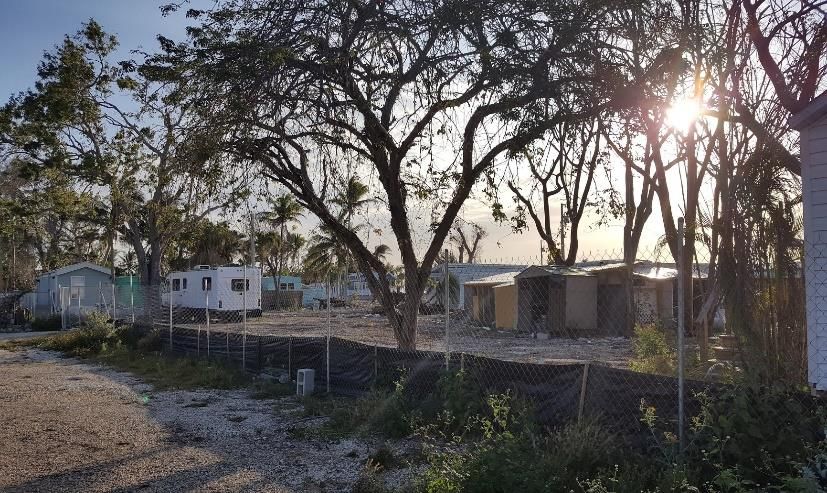
Section 163.3177(6)(a)10.a., Florida Statutes as “the area below the elevation of the Category 1
storm surge line as established by Sea, Lake, and overland Surges from Hurricanes (SLOSH)1
computerized storm surge model. Local governments are required to designate the CHHA on
their Future Land Use Maps series and limit public expenditures that subsidize development
within the CHHA.

BACKGROUND
Hurricanes pose a substantial threat to Florida’s coastal communities. Sea-level rise (SLR) will
increase storm surge height and development in these high-risk areas will intensify storm surge
exposure. Mitigating and adapting to these growing coastal hazards requires the incorporation
of resilience into all aspects of local government, from land use planning to infrastructure
improvements.

In 2014, Islamorada underwent a vulnerability assessment titled Islamorada Matters which
entailed an intensive multifaceted analysis, including a community resilience self-assessment.
The South Florida Regional Planning Council (SFRPC) and Gulf of Mexico Alliance (GOMA) study
described here, builds on the work of Islamorada Matters by adding the compounding risk factor
of storm surge2 to vulnerabilities to SLR. Driven by best-available Light Detecting and Ranging
(LiDAR) data and newly released storm surge data (NOAA, 2016), the SFRPC re-defines the
Coastal High Hazard Area and predicts its future expansion with SLR.

Monroe County has undergone a number of vulnerability assessments including the County’s

1
    A computerized model run by the National Hurricane Center (NHC) to estimate storm surge heights and winds
resulting from historical, hypothetical, or predicted hurricanes by considering pressure, size, forward speed, track,
and winds.
2
    Water that is pushed toward the shore by the force of the winds swirling around the storm. The advancing surge
combines with the normal tides to create the hurricane storm tide, which can increase the mean water level 15
feet or more.

                                                                                                                    5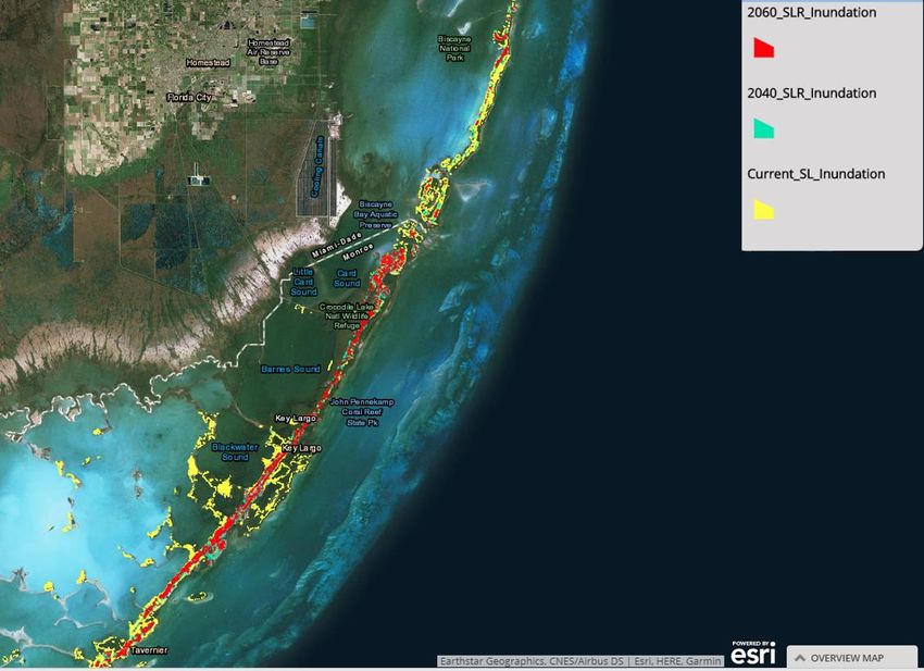
“GreenKeys!” and Monroe County’s inclusion with in the Southeast Florida Regional Climate
Change Compact’s “Analysis of the Vulnerability of Southeast Florida to Sea Level Rise.”

Sea-Level Rise
SLR in South Florida manifests itself prominently via extreme tides, elevated storm surge, and
water tables exceeding ground elevations in low-lying areas. While presently infrequent, these
                                                                     impacts cause transportation delays,
                                                                     compromised           drainage,      property
                                                                     damage, erosion, complications to
                                                                     regional      water      supplies,     habitat
                                                                     degradation, and an array of other costs
                                                                     and inconveniences. During the 2015
                                                                     king tide, neighborhoods in Key Largo
                   King Tide in Monroe County                        were inundated for more than three
                   Photo Credit: The Blue Paper
                                                                     weeks.      This    caused      damage       to
                                                                     resident’s homes, cars, businesses, and
peace of mind. In the Florida Keys, flooding can isolate homes and communities from services
and basic conveniences as the entire archipelago is connected by one main highway.

The Southeast Florida Regional Climate Change Compact (Compact), which is made up of Palm
Beach, Broward, Miami-Dade, and Monroe Counties, reached consensus regarding a unified SLR
projection for their region in 2015 (Figure 1). The Compact estimates approximately 1 foot of
SLR by 2040 and at least 2 feet by 2060 3 . These two scenarios (2040 & 2060) are utilized
throughout this study.

Monroe County can tell the story of rising seas better than most places, as about 90% of the
County’s land mass is at 5 feet or less above sea level (Nature Conservancy, 2017). The property

3
    These projections are in reference to the1992 mean sea levels, which globally have already risen almost 3 inches
in 2015.

                                                                                                                       6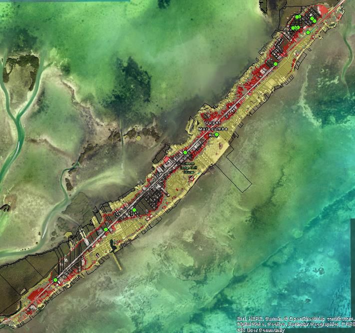
value of land at or below 5 feet elevation is about $27 billion, with 56,000 residents and 76,000
acres are impacted (Nature Conservancy, 2017). Between 1913 and 2006, the Key West tide
gauge measured 9 inches of SLR.

    Figure 1: Unified Sea-Level Rise Projection of the Southeast Florida Regional Climate Change Compact (2015).

Hurricane Risk
Monroe County is highly sensitive to Hurricane
exposure. Between the 1960’s and late 2000’s, Monroe
County was hit by more hurricanes than any other
coastal county (Wilson & Fischetti, 2010). In fact, one of
Islamorada’s tourist attractions is the Hurricane
Monument. This limestone monument was unveiled in
1937 to commemorate the estimated 485 civilian and
veteran lives lost in the 1935 Labor Day hurricane.

As anthropogenic climate change continues, experts
                                                                          The Hurricane Monument in Islamorada
estimate that hurricanes will increase in intensity and

                                                                                                                   7
duration and be potentially harder to track (National Climate Assessment, 2014). If the 2017
hurricane season is any indication of what’s to come (stronger and longer lasting storms with
less predictable trajectories), the time is now to build capacity to be resilient in the face of these
risks.

Purpose of the Study
The results of this research identify inundation for a Category 1 hurricane at current sea levels,
as well as how the CHHA expands alongside two future high SLR scenarios as defined by the
Compact for 2040 and 2060. This study provides insights and information to develop new policy
recommendations when addressing SLR and storm surge in the years to come, including a focus
on incentivizing resilience with the Federal Emergency Management Agency’s (FEMA)
Community Rating System (CRS) Program.

                                                             Study Area
                                                             This study analyzed Monroe County,
                                                             focusing on the Florida Keys with an
                                                             in-depth analysis on Islamorada,
                                                             Village of Islands. The Florida Keys
                                                             are a chain of about 1,7000 islands
                                                             beginning at Soldier Key, south of
                                                             Biscayne     Bay,     and     extending
                                                             southwest toward Key West, and
                                                             ending at the Dry Tortugas.

                                                             Monroe County has a population of
         Figure 2: Property Value below 3 feet in Monroe
                  County (Climate Central, 2017)             75,901 people, with about 20% of the
                                                             population being 65 or older. From
2000 to 2010, the population of Monroe County has decreased by about 6,500 people. Property
value below 3 feet in Monroe County totals about $5.6 billion (Climate Central, 2017).

                                                                                                    8
The main focus of this study
                                                                  is on Islamorada, Village of
                                                                  Islands. Islamorada has a
                                                                  population of 6,386 people
                                                                  with 39.32 miles of paved
                                                                  roads     and     right-of-ways
                                                                  (Islamorada Matters, 2014).
                                                                  Islamorada also holds 5,038
                                                                  homes and 2,102 businesses
                                                                  (Islamorada Matters, 2014).
                                                                  There     are   50    miles   of
                                                                  shoreline, 28.9 acres of
                        Figure 3: Study Area                      geological sites, and 105
                                                                  acres of parks (Islamorada
Matters, 2014). The elevation for
Islamorada differs drastically in some
areas, with some elevations less than
1 foot above sea level while the
majority   ranges from       3-6 feet.
Approximately 42% of Islamorada’s
land use is vacant parcels (Figure 4).

Monroe      County      reports     that,
countywide,     1,179   homes       were
destroyed by Hurricane Irma (August
2017), and another 2,977 homes and
55,000 housing units suffered major
                                               Figure 4: Land Use in Islamorada (FDOT, nd)
damage. Monroe County’s affordable

                                                                                                9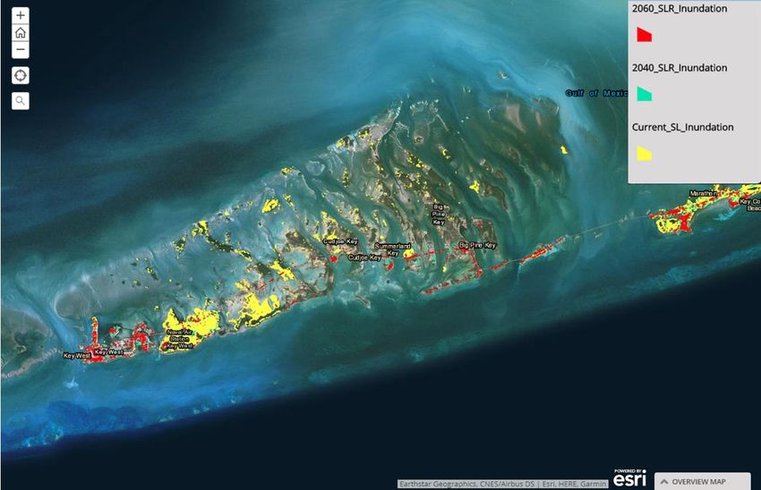
Islamorada Mobile Home Park Post-Irma

housing- mobile homes- were especially hard-hit with 666 destroyed and 378 suffering major
damage. Countless hotels, restaurants, businesses, and shops were also damaged or destroyed.
Given that Monroe County’s economy is dependent on tourism, and thus service industry jobs,
this loss of workforce housing and places of employment has extreme implications on the overall
economy of the County. County-wide, the median gross rent in 2016 was $1,689. Monthly per
capita income is $3,863.75.

Online Webtool for the Study
This study accompanies a ESRI Online StoryMap which can be found at https://arcg.is/1b0Oq0e.
This interactive tool allows interested parties to view the expanded CHHA results at address-
level specificity.

METHODS
This study takes a mixed method approach to provide context to the data-driven modeling
results through stakeholder engagement and key informant interviews. This research model

                                                                                             10
allows us to define the
quantitative spatial boundaries
of risk and the qualitative, social
perceptions of risk.
Quantitative
In order to provide crucial
South Florida SLOSH Basins information on the results of
SLR to storm surge, a GIS
analysis was used with LiDAR data for elevation, current sea levels, and projections for 2 SLR
scenarios for 2040 and 2060, and data from the new SLOSH super basin. This method follows
the National Oceanic and Atmospheric Administration’s Mapping Coastal Inundation methods.
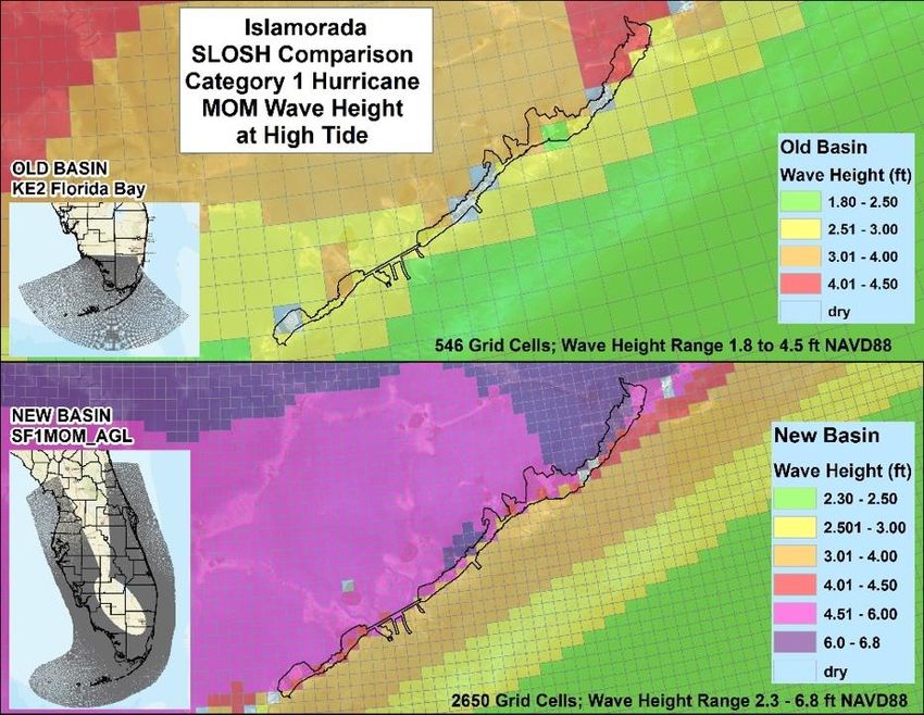
Prior to 2016, South
Florida’s SLOSH model
was composed of 6
separate basins which
overlapped and created
data problems (above left).
In 2016, the National
Oceanic and Atmospheric
Administration National
Hurricane Center (NOAA)
released a new SLOSH
“Superbasin” for South
SLOSH Grid Improvements
Florida (above right). Not
only did the new Superbasin allow for data to flow without interruption from overlapping basins,
but it also increased resolution and took into consideration the buffering effects of mangrove
habitats.
11Even with the improvements in SLOSH grid resolution, the grids can still be up to half a mile in
length and width. The grid needs a single value for surge height assigned to each cell, thus the
grid cell must be transformed into points before the SLOSH data can be compared to the LiDAR
data. The SLOSH cells were converted to points by using the "feature to point" tool. Cells that
were assigned a value of 99.9 are “dry”, meaning the surge height in this area is zero, and the
cells were removed. To smooth out the surface, the "Spline" tool was used to interpolate the
points.
After interpolating the points, the data was then ready to be compared to LiDAR elevations to
determine inundated areas. This was done by using the raster calculator, which subtracts the
LiDAR DEM from the interpolated surface.
This method produced a raster layer representing the inundated areas. Areas containing a
positive value (including zero) represented areas inundated by water. Areas containing a
negative value indicate that the land elevation is higher than the surge height, and therefore the
land is dry. This “wet” raster layer was then converted to polygons, using the raster to polygon
tool, to depict the areas inundated by storm surge.
Qualitative
Interview requests were sent to twenty-five individuals, with a positive response rate of 16%.
These requests were sent to individuals identified as key stakeholders within the following
sectors of the Islamorada community: Retail, Resort/Hospitality, Real Estate, Construction,
Chamber of Commerce, Social Services, Non-Profit, Charter Boat/Ecotourism, Environmental
Education, Senior Living, and local Government (elected and staff members). Participants
include: Cheryl Cioffari (Islamorada’s immediate past Director of Planning), Sheila Denoncourt
(Islamorada’s Chief Building Official), James Mooney (Village Councilman and immediate past
Mayor of Islamorada), and Chris Sante (Mayor of Islamorada).
An interview instrument was developed following extensive research into vulnerability to
12natural hazards. The instrument split ten questions into sections focusing on the components of
vulnerability: exposure, sensitivity, and adaptive capacity. Participants were informed that their
responses could be kept confidential if they so desired and that the goal of the interview was to
determine the social vulnerability of Islamorada. Furthermore, they were informed that the
social vulnerability (ascertained through their interviews) would be paired with the spatial
vulnerability as determined through SLOSH modeling, and thus a more robust understanding of
Islamorada’s vulnerability to storm surge and SLR.
Interviews had an average duration of 50 minutes and were done over the telephone. In depth,
but not verbatim, transcripts were taken during the course of the phone call. Those transcripts
were reviewed immediately afterword to correct punctuation or typing errors.
Analysis of transcripts was done via “Grounded Theory” (Charmaz, 2006). Grounded theory is a
qualitative method of analysis done through a process of constant comparison of three sets of
codes assigned to the data (Punch, 2014). The coding process includes open coding, axial coding,
and selective coding which results in apparent theories associated with the data (Punch, 2014).
This analysis was done through the use of NVIVO 11 Pro software, as is commonly used for
similar qualitative inquires. This method was selected due to the project manager’s expertise in
the method and its application throughout many social science questions regarding
environmental conditions, perceived risk, and ecosystem services.
RESULTS
Monroe County Modeling
The Lower Keys have a lower than average elevation, with most sitting around 5 feet. The lower
elevations make the Lower Keys more vulnerable to storm surge, with most of the islands being
inundated from storm surge at current sea levels. However, Key West, with a maximum
elevation of 18 feet, sees little effects at current sea levels and does not become impacted from
storm surge until there is at least 2 feet of SLR.
13Figure 5: Monroe County Results
Figure 5: Monroe County Results
The Upper Keys, having a higher average elevation, feel the effects of sea-level rise more
gradually. As the sea levels rise, the areas inundated slowly grow with a tipping point between 1
and 2 feet of SLR.
Figure 6: Key Largo and Tavernier
14Figure 7: Middle Keys
Figure 8: Lower Keys
These results show that there is a tipping point between 1 and 2 feet of sea-level rise. There is
minimal change between current sea levels storm surge inundation and 1 foot of SLR
inundation. There is a drastic change between 1 foot of SLR and 2 feet of SLR.
15Islamorada Modeling
As the sea levels increase, so does the CHHA. Higher storm surge occurs with wide, gently
sloping continental shelves, while lower storm surge occurs with narrow, steeply sloping shelves.
Along the Gulf Coast, areas are particularly vulnerable to storm surge because the ocean floor
gradually deepens offshore. Islamorada’s Gulf Coast has a mean surge value of 5.1feet for a
Category 1 hurricane. While the Atlantic side of Islamorada has a steeper shelf, and storm surge
is not as high. The Atlantic side has an average storm surge value of 3.3 feet for a Category 1
hurricane.
The Gulf of Mexico side of
Islamorada has 3,625 parcels
with a mean elevation greater
than 1 foot and 2,695 parcels
with elevations less than 5.1
feet. The Atlantic Ocean side of
Islamorada has 1,605 parcels
with a mean elevation greater
than 1 foot and 668 parcels with
mean elevations less than 3.3
feet.
A Category 1 storm that Figure 9: Islamorada Parcels Inundated under Current Sea Level CHHA
produces an average storm
surge of 5.1 feet Gulf side and 3.3 feet Atlantic side will inundate 50% of Islamorada’s parcels.
With only 2 feet of SLR, the residents of Islamorada are extremely susceptible to inundation
from a Category 1 hurricane. There is a large increase in the land inundated between the 2040 1-
foot rise and the 2060 2 feet rise. While these results are extreme, they provide further evidence
16for the need to expand the CHHA in Islamorada and to prepare for the expansion of it in the years
to come.
Qualitative
The interviews resulted in 339 unique codes. Six selective codes emerged: Preferred Adaptation
Options, Persistence in High-Risk Areas, Obstacles to Adaptation, Identifying Sensitive Assets
and Populations, Community Depends on Environment for Tourism, and Prioritizing Storm and
Flood Resistant Affordable Housing as Resilience.
Figure 10: Qualitative Results Visualized
The most mentioned adaptation option across all interviews was mandating that building codes
require building elevations greater than 1 foot above base flood elevation, followed by actions
taken by private homeowners. Both hardening infrastructure and green infrastructure options
were discussed as valuable adaptation opportunities. Currently, Islamorada’s Comprehensive
17Plan and associated codes do not permit hardening of coastal infrastructure nor dredging of the
“backcountry” (Gulf side), both of which were mentioned by more than one participant as a
necessary and effective adaptation action.
By in large, the participants are rooted in place and are unwilling to consider retreat from the
Florida Keys as a viable option. Instead, participants noted that property values have not
lowered due to risk or storm damage, living with the water and risk of flooding is part of the
Keys’ culture, and that Islamorada is forced to continue re-developing in areas impacted by
storm surge or flooding because “high risk areas are anywhere with a coast.” In fact, one
participant noted that they would be happy to park their car in Homestead (an hour’s drive by
car) and drive a boat to their home which they would equip with bio-composting toilets and a
reverse osmosis system if it meant they still can live in Islamorada. The culture of the Keys
regarding storm, flood, and sea-level rise risks is that of “bring it on” as participants stated.
Participants stated that they believe its “human nature” to challenge adversity rather than
accept defeat. In fact, participants noted that the only tipping point for remaining in the Keys,
despite the risks, is the eventual removal of Flood Insurance in the area.
Participants identified obstacles as a general unwillingness to pay for long-term, expensive,
public adaptation options that they themselves would not see the benefit of. Additionally, these
obstacles include a need for more buy-in from elected officials, a small sector of the public and
Village staff who deny climate change is occurring, and issues associated with illegal dumping
and removal of native plans following storm damage events.
Special attention was paid to sensitive populations, primarily the working poor who support
tourism within Islamorada. According to the participants, these individuals live in “illegal”
downstairs apartments and in mobile homes which are largely not compliant with flood
requirements. In addition, Village staff wished to bring attention to outdoor laborers, specifically
day laborers and landscapers, who would suffer from extreme heat as a product of global climate
18change. Participants expressed concern regarding the working-class residents who support the
local tourism economy through service industry jobs.
Participants listed parts of the community which they consider to be critical infrastructure which
should be prioritized in the aftermath of a storm or flood event and also in adaptation: beaches,
electric service, fire rescue, grocery stores, hospitals, resorts, affordable housing, roads, schools,
wastewater management, freshwater resources, and sewer systems. Aspects of this list which
are not usually listed as critical infrastructure illustrate the unique tourism-based economy in
Islamorada. Without resorts, beaches, and workforce housing the Village cannot survive. In the
words of Islamorada’s Mayor James Mooney, “without tourists there are not enough of us [local
residents] to sustain the businesses that exist.” The results of this qualitative inquiry were used
in the site inspection shown below. Participants expressed a desire to fortify these aspects of
local infrastructure to the highest level possible, be that a 500-year flood by FEMA standards or
the Highest Sea-Level Rise projection.
The selective “prioritizing storm and flood resistant affordable housing as resilience” emerged
through extensive comment regarding the damage mobile home parks and illegal downstairs
apartments suffered from Hurricane Irma. All participants agreed that Islamorada is in need of
flood code compliant affordable housing options. However, many participants noted that
Islamorada doesn’t have the land area to provide the necessary amount of affordable housing.
In efforts to become more resilient to storm surge and sea-level rise, elevated and code
compliant affordable housing must be prioritized along with the fortification of other critical
infrastructure.
Site Inspections
The Project Manager carried out site inspections of areas projected to be inundated by the
expanded CHHA in March 2018. A map and associated pictures of locations can be found here.
19Social Vulnerability
Including both spatial and social vulnerability in vulnerability assessments is a best practice. In
2003, Susan Cutter developed the Social Vulnerability Index (SoVI) which is utilized by the
Figure 11: Social Vulnerability of Islamorada by Census Tracts (SoVI 2006-2010 Florida)
Federal Emergency Management Administration, the Center for Disease Control, and the
Florida Department of Health among other agencies. The SoVI Index utilizes 30 socioeconomic
variables, provided by the U.S. Census Bureau, which have been shown to impact a community’s
ability to prepare, respond, and recover from a variety of environmental hazards, including
natural hazards such as flooding. Figure 11 shows Islamorada’s SoVI score by census tract.
20Workshop
On March 8, 2018 the SFRPC, in partnership
with the Village of Islamorada, hosted a
“Community Resilience Workshop” which was
open to the public. This workshop focused on
communicating SLR and storm surge risks to
local leaders and residents. The goal of the
workshop was for community members to build
capacity to be resilient to future risks. Monroe
County Mayor David Rice introduced the day’s
discussion by connecting future risks with the
risks overcome by early Monroe County
settlers. Following the introduction were
presentations by Dr. Keren Bolter (Arcadis),
Leah Stockton (United Way of the Florida Keys),
Vicki Boguszewski (Yogi in Ya Public Health
Consultant), Chris Bergh (The Nature Conservancy), and Elmira Leto (Samuel’s House). Patxi
Pastor, of the Celebration of the Sea Foundation and Keysstrong.org, then convened a panel
discussion which focused on increasing Islamorada’s resiliency to SLR and storm surge. An
audience of over 50 individuals attended including community leaders, elected officials,
municipal staff, non-profit professionals, and the general-public.
Video of the workshop, meeting agenda, and notes can be found on the interactive web portal.
DISCUSSION
As Mayor Rice alluded to, the Monroe County area has persevered amidst natural disasters for
almost 200 years. Today, facing unprecedented and uncertain risks from SLR, the community is
provided with an opportunity to take proactive steps to thrive.
21Participants identified an unwillingness to pay for adaptation when the results won’t be realized
within their lifetime. Even though adaptation can cost a tremendous amount of tax-payer
money, the cost of inaction is higher. A report from the National Institute of Building Sciences
found that for every $1 spent on disaster resilience, society saves $6. Furthermore, a recent
study done by the Union of Concerned Scientists estimates that 1,497 homes, valued at
approximately $1.08 billion within Islamorada’s 33036 zip code will be inundated by chronic
nuisance flooding by 2060 according to NOAA’s High Projection of 2 feet SLR. According to
2010 Census counts, this is 26% of the housing units in Islamorada. These inundated properties
are projected to put $10.4 million of property taxes at risk. If these chronically inundated homes
become abandoned physically and financially, Islamorada is at risk of losing 33% of taxable real
property value for its budget. With available ad valorem taxes projected to decrease with chronic
flooding, the time is now to invest in Islamorada’s resilience and claim the 1:6 return on
investment.
The results from our interviews and workshop are clear that Islamorada residents do not accept
retreat as a viable option. Participants noted that the only conceivable tipping point in favor of
retreat would be the loss of the subsidized National Flood Insurance Program (NFIP).
Regardless, Islamorada has taken proactive steps to establish a Conservation Easement
Program in 2005, placing 71 properties into the Program and starting the managed retreat of
8.98 acres. Investing in this adaptation measure maximizes co-benefits provided by natural
infrastructure in a nature-based tourism locale. Very few places in the United States have
established a Conservation Easement Program as an adaptation measure, mostly due to fear of
takings issues. Islamorada, on the other hand, has been successful in maintaining this Program
for over a decade.
The data displayed in this report speaks for itself and identifies a hazard tipping point of 2 feet
of SLR. Socially, the tipping point has been identified as the loss of NFIP. With the persistence
to stay amidst certain and uncertain risks, time is of the essence to fund adaptive capital
improvements, develop differently, and educate residents of the risks related to SLR and storm
22surge.
RECOMMENDATIONS
Planning and Policy
This report supports the recommendations made in Islamorada Matters. Provided below are the
supplementary recommendations:
By end of FY2019
• Amend the Village Code of Ordinances Chapter 6, Article II to include an additional 3 feet
of freeboard required for new buildings.
• Expand existing natural coastal defenses on undeveloped land which are shown to be
inundated by SLR and storm surge (Appendix A).
• Order the immediate review of any hazardous waste facility (transfer station, debris
staging areas, businesses with registered underground storage tanks, or other potential
sources of hazardous waste) within projected inundation area or areas flooded within the
23past 5 years to ensure seepage has not occurred and the waste is contained as mandated
by the Florida Department of Environmental Protection (FDEP) (Appendix A).
• Begin employee and elected official climate change literacy training which will be a
required part of onboarding for future employees. Examples or models for this training
include: US Global Change Research Program's "The Essential Principles of Climate
Literacy, "US Forest Service "Climate Change Science and Modeling" module, and US
EPA "Climate Change Adaptation Introductory Training."
• Prioritize the inclusion of Lower Matecumbe in the Conservation Easement Program.
By end of FY2020
• Prioritize the expansion of high-quality native habitats and/or stormwater parks in
Village owned parcels of land which are modeled to be inundated (Appendix A). Do this
via conservation easements and engagement with environmental scientists and/or local
groups such as the Nature Conservancy.
• Focus conservation easements in present-day and future CHHA areas. Within those
areas, focus on Native Residential zoned properties.
• Create an “Adaptation Action Area” overlay zone composed of the projected expansion
of the CHHA. This zone will be associated with larger coastal setbacks than previously
required for all new development, increased elevation requirement above Base Flood
Elevation (BFE), and the strong incentivization of resilient affordable housing within any
major project within the overlay zone.
• Update the Capital Improvement Element of the Village’s Comprehensive Plan to
incorporate an increase of at least 20% more funding for the armoring of critical facilities
(e.g. water/sewer, electric grid, healthcare facilities, telecommunications infrastructure,
schools, and social services) which are projected to be inundated. Carry out these
improvements within a 10-year time frame.
• Draft a Post-Disaster Redevelopment Plan which includes SLR as a hazard and is in
coordination with the Monroe County Post-Disaster Redevelopment Plan (PDRP).
24Ensure that the hospitality and tourism industry is included as stakeholders in the PDRP
process, among other stakeholders.
• Update the Stormwater Master Plan to include this study’s results.
• Designate all of Lower Matecumbe as an Adaptation Action Area.
• Incorporate Low Impact Development site design techniques into building and landscape
code.
• Institute a resident marine debris education program focusing on debris around
properties which would become marine debris in the event of storm surge or flooding.
• Re-run the Sea-level Rise Affecting Marshes Model (SLAMM) with any new data to
estimate impacts or changes to habitats.
By end of FY2021
• Work with Florida Department of Transportation, District 6 Emergency Management
Office to identify potential funding to elevate and improve drainage of roadways on
Lower Matecumbe which are frequently washed out in storm events.
• Employ urban design stormwater management best practices such as bioswales, flow-
through-planters, pervious strips, and pervious roadway materials for improved drainage
on local roadways.
• Establish a 50-year planning horizon in the Capital Improvement Element which is
situated within the 2060 SLR Scenario or other best available data.
• Partner with FDEP to order a review of the solid waste facilities within the Village and
their elevation certificate versus SLR and storm surge. Ensure that these facilities are
protected from inundation and storm surge.
• Amend the Coastal Management Element of the Comprehensive Plan to reflect risks
modeled in this work and the requirements set forth in Peril of Flood law.
25By end of FY2022
• Put all existing Village owned mangrove or wetland habitat into a Land Trust (Florida
Keys Coastal Land Trust). The Land Trust shall ensure that the existing coastal defenses
are not developed nor hindered by nearby shoreline hardening.
• Begin coordination with Monroe County and other municipalities to expand the Florida
Keys Coastal Land Trust to other locations throughout the county.
• Contract work with carbon finance experts, like those at Tierra Resources or Finite
Carbon, to earn income from Land Trust Management to further conservation goals and
fund the Land Trust.
By end of FY2024
• Attain Accreditation for the Florida Keys Coastal Land Trust via Land Trust Accreditation
Commission.
Adaptive Capacity
• Continue to enhance reef structures (coral, oyster, sponge, etc.) offshore as a buffer for
storm surge. This would include continued attention to the Coral disease which is
plaguing reef-building corals in the Florida Reef Tract.
• Continue to work with the Army Corps of Engineers to re-nourish and re-plant beaches.
• Increase public outreach regarding risks and opportunities provided by a changing
climate.
• Encourage radical creativity via an annual “Reimagining Islamorada” art or essay contest
which considers possible futures and landscapes with rising sea levels. Examples include
Dover Rising Waters and the Trinidad and Tobago Climate Change Art Competition.
• Continue striving for a better FEMA CRS score as a community.
• Implement Litter Prevention Sculptures in areas not within the CHHA. Keep Golden Isles
Beautiful (Georgia) provides an example. Make the sculptures tourist attractions by
keeping with the Florida Keys Kitsch style, yet ensure the sculptures are well secured and
do not become marine debris themselves in the event of a hurricane.
26Appendix
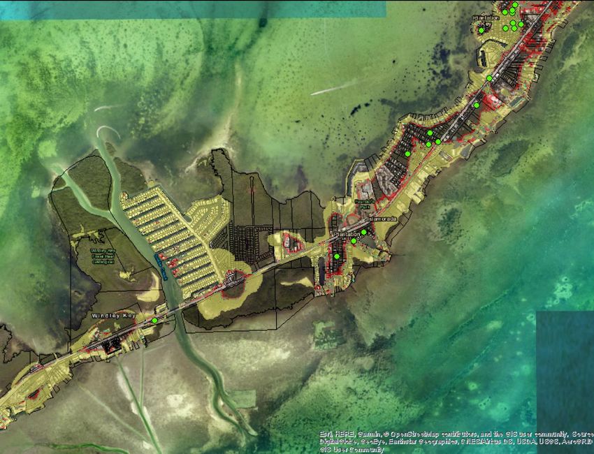
A: Maps
1) CHHA and Vacant Properties
272) FDEP Hazardous and Clean-Up Sites and the Coastal High Hazard Area
283) Properties Currently under Conservation Easement and Present Day CHHA
294) Properties Currently under Conservation Easement and CHHAs (Islamorada and subsequent South to
North Close-Ups)
3031
32
33
34
You can also read