The prediction of floods in Venice: methods, models and uncertainty (review article)
←
→
Page content transcription
If your browser does not render page correctly, please read the page content below
Nat. Hazards Earth Syst. Sci., 21, 2679–2704, 2021
https://doi.org/10.5194/nhess-21-2679-2021
© Author(s) 2021. This work is distributed under
the Creative Commons Attribution 4.0 License.

The prediction of floods in Venice: methods,
models and uncertainty (review article)
Georg Umgiesser1,2 , Marco Bajo1 , Christian Ferrarin1 , Andrea Cucco3 , Piero Lionello4 , Davide Zanchettin5 ,
Alvise Papa6 , Alessandro Tosoni6 , Maurizio Ferla7 , Elisa Coraci7 , Sara Morucci7 , Franco Crosato7 ,
Andrea Bonometto7 , Andrea Valentini8 , Mirko Orlić9 , Ivan D. Haigh10 , Jacob Woge Nielsen11 , Xavier Bertin12 ,
André Bustorff Fortunato13 , Begoña Pérez Gómez14 , Enrique Alvarez Fanjul14 , Denis Paradis15 , Didier Jourdan16 ,
Audrey Pasquet16 , Baptiste Mourre17 , Joaquín Tintoré17 , and Robert J. Nicholls18
1 ISMAR-CNR,       Institute of Marine Sciences, National Research Council, Venice, Italy
2 Marine   Research Institute, Klaipeda University, Klaipeda, Lithuania
3 IAS-CNR, Institute for the study of Anthropic impacts and Sustainability in the marine environment,

National Research Council, Oristano, Italy
4 DiSTeBA – University of Salento, Lecce, Italy
5 Department of Environmental Sciences, Informatics and Statistics, University Ca’ Foscari of Venice, Mestre, Italy
6 CPSM, Centro Previsione e Segnalazione Maree – Protezione Civile, Venice, Italy
7 Italian Institute for Environmental Protection and Research, ISPRA, Venice, Italy
8 Arpae-SIMC – Regional Agency for Prevention, Environment and Energy of Emilia-Romagna,

Hydro-Meteo-Climate Service, Bologna, Italy
9 Department of Geophysics, Faculty of Science, University of Zagreb, Zagreb, Croatia
10 School of Ocean and Earth Science, National Oceanography Centre, University of Southampton, Southampton, UK
11 DMI – Danish Meteorological Institute, Copenhagen, Denmark
12 UMR 7266 LIENSs, CNRS-La Rochelle University, 2 rue Olympe de Gouges, 17000 La Rochelle, France
13 Laboratório Nacional de Engenharia Civil, Lisbon, Portugal
14 Puertos del Estado, Madrid, Spain
15 Direction des Opérations pour la Prévision, Département Marine et Océanographie, Météo-France, Toulouse, France
16 Shom (Service hydrographique et océanographique de la Marine), Toulouse, France
17 SOCIB, Balearic Islands Coastal Observing and Forecasting System, Mallorca, Spain
18 Tyndall Centre for Climate Change Research, University of East Anglia, Norwich, UK

Correspondence: Georg Umgiesser (georg.umgiesser@ismar.cnr.it)

Received: 29 October 2020 – Discussion started: 17 November 2020
Revised: 13 May 2021 – Accepted: 25 May 2021 – Published: 1 September 2021

Abstract. This paper reviews the state of the art in storm       surge forecasting to control their operation. In this paper, the
surge forecasting and its particular application in the north-   physics behind the flooding of Venice is discussed, and the
ern Adriatic Sea. The city of Venice already depends on op-      state of the art of storm surge forecasting in Europe is re-
erational storm surge forecasting systems to warn the pop-       viewed. The challenges for the surge forecasting systems are
ulation and economy of imminent flood threats, as well as        analyzed, especially in view of uncertainty. This includes
help to protect the extensive cultural heritage. This will be    consideration of selected historic extreme events that were
more important in the future, with the new mobile barri-         particularly difficult to forecast. Four potential improvements
ers called MOSE (MOdulo Sperimentale Elettromeccanico,           are identified: (1) improve meteorological forecasts, (2) de-
Experimental Electromechanical Module) that will be com-         velop ensemble forecasting, (3) assimilation of water level
pleted by 2021. The barriers will depend on accurate storm       measurements and (4) develop a multimodel approach.

Published by Copernicus Publications on behalf of the European Geosciences Union.
2680 G. Umgiesser et al.: The prediction of floods in Venice: methods, models and uncertainty (review article)
1 Introduction liability of these forecasts will contribute to avoid missing
or false closures due to predictions that are too low or too
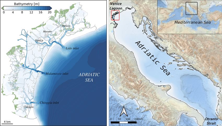
The city of Venice is situated inside the Venice Lagoon, high. This will save money as missing closures could result
which is connected to the Adriatic Sea by three inlets (Fig. 1). in flooding and damage to the city of Venice (shops, low ly-
Due to its low elevation with respect to mean sea level, for ing apartments), while false closures will unnecessarily delay
centuries the city was subject to occasional floods due to ship passage for its industrial and touristic ports (Vergano et
storm surge events, called Acqua alta. During the last cen- al., 2010). Moreover, the forecast is essential to warn the pop-
tury the frequency of flooding has steadily increased (Ferla ulation of imminent danger to life and goods and to prepare
et al., 2007; Lionello et al., 2021a) due to local land sub- boat travel and walkways for pedestrians inside the city.
sidence and relative sea level rise driven mainly by climate From a historical perspective, the need to alert the popula-
change (Carbognin et al., 2004; Zanchettin et al., 2021). tion, protect commercial activities and organize transport and
The last 3 years have seen some of the most devastating pedestrian mobility during floods of the Venice city center
high water events that Venice has ever experienced. In Oc- was motivated by the development of surge prediction tools.
tober 2018 a storm produced a sea level 156 cm over datum Early studies were published in the 1970s in the wake of the
(see Fig. 2 for a reference of the local datum and the flood- initiatives motivated by the response to the dramatic flood in
ing levels of Venice). In November and December 2019, a November 1966 (Finizio et al., 1972; Robinson et al., 1973;
series of storms created five high tides with water levels ex- Tomasin, 1973; Tomasin and Frassetto, 1979). Development
ceeding 140 cm. These events are called exceptional because resumed in the 1990s, partially in association with the per-
only 25 such events have been observed in the last 150 years. spective of developing a system with the accuracy required
They flood nearly 60 % of the pedestrian walkways in the city for operating the MOSE system (Vieira et al., 1993; Lionello,
and cover S. Mark’s square with 60 cm of water. One of these 1995; Petaccia and Sallusti, 1995; Lionello et al., 1998; Bar-
high tides was the second highest water level ever measured gagli et al., 2002).
in Venice at 189 cm which was only exceeded by the terrible This paper provides a state-of-the-art review of water level
flood in 1966 at 194 cm (Cavaleri et al., 2020). forecasting for the city of Venice. It presents the geographical
These flooding events pose a threat not only to the artistic, setting of the city and the processes giving rise to the occur-
cultural and environmental heritage but also to the economic rence of high waters and flooding in Venice. It then reviews
assets. To be able to face these events and to manage their the forecasting capabilities across Europe where various in-
occurrence, there have been investments in the safeguarding stitutions conduct operational forecasting, including for the
of Venice through the planning and building of flood barriers, Adriatic Sea and the Venice Lagoon. Different methodolo-
many other structural measures, and forecasting operational gies are presented that, in addition to the ones already opera-
systems, measurement networks and extreme event research tional, could significantly improve the forecasting system for
activities (Barbano et al., 2012; Demarte et al., 2007). Venice, including the operation of the MOSE barriers.
Venice is tackling the problem of high water flooding
by building mobile barriers (called MOSE, MOdulo Speri-
mentale Elettromeccanico, Experimental Electromechanical 2 Geographic setting
Module) at each inlet of the lagoon. These gates sit on the
seabed, and compressed air is introduced into them to empty 2.1 The Adriatic Basin
them of water, and they rise up until they emerge above the
water to stop the tide from entering the lagoon. Construc- The Adriatic Sea is an epicontinental basin within the east-
tion has been underway since 2004 and has been criticized ern Mediterranean Sea extending southeastward from 46◦ N,
by many due to the elevated costs and the long timescale of 12◦ E to 40◦ N, 19◦ E, approximately 780 km long and 120–
construction. However, it is the only intervention that will be 200 km wide (see Fig. 1 for reference).The bathymetry is
able to effectively defend Venice from flooding due to storm characterized by a shallow northern shelf with water depths
surges in the near and medium future (Consorzio Venezia lower than 80 m, gently sloping in depth towards the middle
Nuova, 1997). MOSE is presently being commissioned and part up to 250 m in the Jabuka Pit. The Palagruza Sill, 170 m
is expected to be fully operational by the end of 2021. deep, marks the beginning of the southern Adriatic, which
The operation of the MOSE uses a complex protocol extends up to Strait of Otranto separating the basin from the
including water level measurements and atmospheric and rest of the eastern Mediterranean Sea. In the southern Adri-
oceanographic forecasting. In particular, the decision to close atic the bathymetry reaches 1200 m at the bottom of a wide
the MOSE will depend on the water level forecast. Once a de- depression known as the southern Adriatic Pit.
cision to close the MOSE has been taken, the exact time of The general circulation of the basin is mainly cyclonic and
closure will be decided based on water level measurements primarily thermohaline, driven by a combination of surface
inside the lagoon (Consorzio Venezia Nuova, 2005). Hence, buoyancy fluxes, river discharges and exchanges through
water level forecasting is one of the fundamental aspects of the Strait of Otranto (Poulain and Cushman-Roisin, 2001).
the closing procedure of the mobile gates. Improving the re- Along the eastern perimeter, the eastern Adriatic Current
Nat. Hazards Earth Syst. Sci., 21, 2679–2704, 2021 https://doi.org/10.5194/nhess-21-2679-2021
G. Umgiesser et al.: The prediction of floods in Venice: methods, models and uncertainty (review article)                   2681

Figure 1. Setting of the Venice Lagoon and the Adriatic Sea.

flows northward transporting saline Levantine Intermediate       lets with widths ranging from 500 to 1000 m. The depths of
Water (Artegiani et al., 1989), while on the western border,     these inlets range from 7 to 13 m, depending on the inlet. The
the western Adriatic Current transports fresher surface wa-      lagoon, during spring tide, has a peak exchange of around
ter from the northern Adriatic toward the Straight of Otranto    20 000 m3 s−1 with the Adriatic Sea, a very high amount con-
(Bignami et al., 1990a, b). Along this side of the basin, a      sidering that the average of the Po discharge is only around
deeper southward flow is also generated during the winter        1500 m3 s−1 (Gačić et al., 2004).
by the outflow of dense water masses generated in the north-        The lagoon itself is quite shallow, on average around
ern part of the basin (Malanotte-Rizzoli, 1977; Artegiani et     1.5 m. Most areas are only 80 cm deep, but there are deep
al., 1989, 1997a, b). The order of magnitude of the surface      tidal channels that cut through the very shallow parts. An-
boundary currents (about 20 cm s−1 ; Poulain, 2001) suggests     other particularity of the lagoon are the salt marshes that
that changes in sea surface elevation induced by geostrophic     cover around 15 % of the total area (Umgiesser et al., 2004).
balance are negligible.                                             The tidal wave (tidal range 1 m) propagates mainly along
   The tidal regime has been interpreted as co-oscillations      the deep channels and then expands into the more shallow ar-
with the Mediterranean Sea, forced through the Strait of         eas (Rinaldo, 2001). The delay between the signal at the be-
Otranto and amplified by resonance phenomena along its           ginning of the inlets and the city center is 40 min. What con-
longitudinal direction from south to north (Polli, 1961). The    cerns the amplitude of the oscillation there is neither water
tidal dynamics are particularly evident in the northern Adri-    level damping nor amplification, so the water level reaches
atic Sea, where the tidal range reaches values of more than      the center of the lagoon nearly undisturbed (Ferrarin et al.,
1 m at spring tide (see Sect. 3.1).                              2015).
   Over the Adriatic Sea, between October and March, me-            During the last 500 years major engineering works have
teorological disturbances are frequently and usually charac-     been carried out inside the lagoon, including diversion of
terized by the passage of low-pressure systems or cyclones.      rivers, building of the inlet jetties, and dredging both existing
These are often associated with strong southeasterly winds,      and new artificial channels (Gambolati and Teatini, 2014).
the sirocco, as the cyclone approaches from the west, and        One of these channels, the Petroli channel, which runs from
with northeasterly katabatic winds, the bora, as the cyclone     the central inlet across the lagoon to the industrial area, has
travels eastwards. These two winds represent the dominant        been indicated to have worsened the phenomenon of Acqua
wind regimes during the winter period (see Sect. 3.2).           alta inside the lagoon. This is, however, not the case because
                                                                 modeling studies show that the water level enhancement is
2.2   The Venice Lagoon                                          limited to a few millimeters (Umgiesser, 1999). Much more
                                                                 influence (some centimeters of reduction) has resulted from
The Venice Lagoon is situated at the northwestern end of the     the creation of reclaimed areas where fish farming is carried
Adriatic Sea (Fig. 1). It is connected to the sea by three in-   out inside the lagoon.

https://doi.org/10.5194/nhess-21-2679-2021                              Nat. Hazards Earth Syst. Sci., 21, 2679–2704, 2021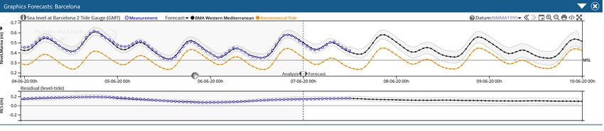
2682             G. Umgiesser et al.: The prediction of floods in Venice: methods, models and uncertainty (review article)

                                                                         age elevation of these islands is less than 1 m above the mean
                                                                         sea level (see Fig. 2 for reference). The Grand Canal is the
                                                                         main watercourse of this intricate network, in the shape of
                                                                         a large “S”. The overall length of the canal system is about
                                                                         40 km and its surface corresponds to, approximately, 10 %
                                                                         of the total urban area (Zonta et al., 2005). The hydrody-
                                                                         namic regime in the canals is driven by tidal forcing as a
                                                                         consequence of phase lags and level gradients occurring at
                                                                         the city boundary. During the flood tide the flow is predomi-
                                                                         nantly from southeast to northwest, while the direction is re-
                                                                         versed during the ebb (Coraci et al., 2007). The current speed
                                                                         in the network is low, with average maximum values up to
                                                                         25 cm s−1 throughout the tidal cycle.
                                                                            In the last century the city of Venice faced an increase
                                                                         in frequency and intensity of flooding events that periodi-
                                                                         cally submerged parts of the old city center due to the com-
                                                                         bined effect of climate change and subsidence (Baldin and
                                                                         Crosato, 2017; Carbognin et al., 2004). The increasing fre-
                                                                         quency of inundations represent a serious problem for citi-
                                                                         zens, businesses and tourist activities. In October 2018 and
                                                                         November 2019, Venice and the northern Adriatic have been
                                                                         exposed to extreme marine conditions (sea level, waves; see
                                                                         also Fig. 2) in turn induced by extreme weather conditions
                                                                         (Morucci et al., 2020). A complete list of other extreme
                                                                         events can be found in Lionello et al. (2021b).
                                                                            These flooding events pose a threat not only to the artistic,
                                                                         cultural and environmental heritage but also to the economic
                                                                         assets. To be able to face these events and to manage their
                                                                         occurrence, there have been investments in the safeguarding
                                                                         of Venice through the planning and building of flood barriers,
                                                                         many other structural measures, and forecasting operational
                                                                         systems, measurement networks and extreme event research
Figure 2. The local datum of Venice, the height of the lowest pave-      activities (Barbano et al., 2012; Demarte et al., 2007).
ment level, the flooding percentages, definition of various alert lev-
els and the height of important historic floods. Please note that the
mean sea level of the last 10 years is approx. 32 cm above datum.
Therefore, at spring tide the water level reaches values of over 80 cm   3     The physics behind flooding in Venice
without any meteorological contribution.
                                                                         This section provides an overview of processes that influence
                                                                         and dominate the water level in front of and inside the La-
   Apart from the local wind effect that can shift water                 goon of Venice. The processes considered are tides, wind,
masses inside the lagoon and can create water level differ-              atmospheric pressure and seiches.
ences of up to 50 cm between the north and south end, the
level at the city of Venice is mostly determined by the wa-              3.1    Tides
ter level just outside the inlets (Zecchetto et al., 1997). This
means that the water level forecast can be divided into two              Fluctuations of Adriatic Sea level and currents at tidal fre-
different stages: the first one where the water level is deter-          quencies are among the largest in the entire Mediterranean
mined at the lagoon inlets and the second one where the ef-              Sea (Tsimplis et al., 1995). The tidal regime in the Adriatic
fects inside the lagoon are taken into account.                          Sea has been interpreted as co-oscillations with the Mediter-
                                                                         ranean Sea, forced through the Strait of Otranto and ampli-
2.3    The city of Venice                                                fied by resonance phenomena along its longitudinal direc-
                                                                         tion from south to north (Cushman-Roisin et al., 2001; Vili-
The city of Venice is located in the central part of the lagoon          bić et al., 2017). Consequently, tidal dynamics are particu-
and is situated on a group of 118 small islands that are sep-            larly evident in the northern Adriatic Sea, where the tidal
arated by almost 160 canals (known as “rii”) having widths               range reaches values of more than 1 m at spring tide. For
from a few to tens of meters and depths of 1–5 m. The aver-              this reason, even without a meteorological contribution, dur-

Nat. Hazards Earth Syst. Sci., 21, 2679–2704, 2021                                       https://doi.org/10.5194/nhess-21-2679-2021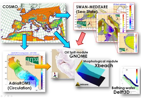
G. Umgiesser et al.: The prediction of floods in Venice: methods, models and uncertainty (review article)                     2683

ing spring tide some parts of S. Mark’s square are already          raphy of the Dinaric Alps on the eastern Adriatic coast, cre-
flooded (Fig. 2). Only seven tidal constituents, four semidiur-     ates fine-structured jets and lee wakes with strong sub-basin-
nal (M2, S2, N2 and K2) and three diurnal (K1, O1 and P1),          scale spatial gradients across the northern Adriatic, reaching
give a significant contribution to the evolution of sea surface     gusts of about 100 km h−1 and up to 200 km h−1 . Its strength
elevation in the northern Adriatic Sea, reaching a range of         is due to the gradient created by warm air over the sea surface
1 m in the Trieste bay (Polli, 1961; Mosetti and Manca, 1972;       and the cold area over the coastal mountains.
Cushmain-Roisin et al., 2001; Orlić, 2001; Book et al., 2009)         Two types of bora are known in the northern Adriatic: the
and resulting in a mixed, mainly semidiurnal tidal regime           bora scura, which is characterized by windy and rainy con-
(Ferrarin et al., 2015, and references therein). The tidal form     ditions caused by a cyclone centered over the south of Italy
factor, consisting of the ratio of the amplitudes of the ma-        and an anticyclone over northern Europe, and bora chiara,
jor diurnal and semidiurnal tidal constituents, reveals that the    which is a cold, violent, dry, gusty wind and is typically as-
semidiurnal tidal regime (F < 1) prevails in the Adriatic Sea,      sociated with a strong anticyclone over central and eastern
although the tide maintains a diurnal character (F > 3) in the      Europe which conveys cold air falling on the Adriatic Sea
proximity of the semidiurnal amphidromic points located in          surface through the various gaps and valleys of the Julian and
the middle of central Adriatic Sea (Ursella and Gacic, 2001;        Dinaric Alps. Both types of wind events can generate large
Lovato et al., 2010; Ferrarin et al., 2017).                        waves and storm surges in the northern Adriatic, and espe-
   Tidal propagation in the shallow Venice Lagoon is con-           cially in Venice, with different coastal impacts depending on
trolled by many factors which define the relationship among         the different morphology that characterizes the eastern Ital-
the celerity of the tidal wave, the inertia of the water mass and   ian coast and the western Croatian one (Ferrarin et al., 2020).
dissipative forces due to friction. While propagating from the
inlets to the lagoon, the tidal wave is deformed according to a     3.3   Low-pressure systems
relationship between local flow resistance and inertia and the
characteristics of the incoming tidal wave. At present, the in-     The passage of cyclones over the Mediterranean Sea pro-
coming tidal wave is amplified in the lagoon indicating that        duces positive and negative sea anomalies which reach their
the driving and reflecting tides are close to the condition of      largest amplitude in the north Adriatic Sea and in the Gulf of
resonance. As a consequence of natural and anthropogenic            Gabes (Lionello et al., 2019). The synoptic conditions lead-
morphological changes that occurred in the lagoon in the last       ing to floods along the Adriatic coast (e.g., beside Venice,
century, the amplitude of major tidal constituents grew, with       in Trieste and Dubrovnik) consist of a driving low-pressure
a consequent increase in extreme high sea levels in Venice          center over central Europe and frequently of an associated
(Ferrarin et al., 2015).                                            cyclogenesis south of the Alps (Robinson et al., 1973; Trigo
                                                                    and Davies, 2002; Lionello, 2005; Lionello et al., 2019). In
3.2   Wind action                                                   fact, a cyclone generated in the northwestern Mediterranean
                                                                    produces the largest storm surge events through a combina-
Due to the shape and the surrounding orography, the Adriatic        tion of inverse barometer effect and wind stress acting over
Sea, and in particular the northern Adriatic, is mainly char-       shallow water (Lionello et al., 2012). The characteristics of
acterized by two wind regimes: the southeasterly sirocco and        the wind field and the cyclone track determine which loca-
the northwesterly bora (Pasarić et al., 2009).                     tion in the Mediterranean is most affected (Lionello et al.,
   The sirocco is generally considered a basin response with        2012; Meðugorac et al., 2018). The cyclogenesis in the west-
large spatial scales (Signell et al., 2005). It is a warm and       ern Mediterranean Sea is triggered by the interaction between
wet wind mainly associated with a minimum atmospheric               the frontal layer of the primary cyclone and the Alps, and it
pressure located in the northwestern Mediterranean or in the        evolves as a baroclinic instability perturbed by the orography
Tunisia–Sicily channel. It is channeled along the main axis         (Buzzi and Tibaldi; 1978, Buzzi and Speranza, 1986; Sper-
of the Adriatic Sea by the bordering orography and blows of-        anza et al., 1985), which is further modified by the moist
ten along the whole length of the basin, usually with a wind        Mediterranean environment (Benzi et al., 1997; Krichak and
speed between 10 and 15 m s−1 (Lionello et al., 2012). As           Alpert, 1998). The presence of an area with frequent cyclo-
a consequence it causes high waves and rain, and when a             genesis in the northwestern Mediterranean Sea is evident in
strong sirocco blows over the Adriatic, the water is piled-up       the climatological maps (e.g., Lionello et al., 2016).
in the northern part of the basin. In combination with tides
it is the main driver of flooding in Venice and in general in       3.4   Seiches
the shallow coastal regions. It can also trigger resonance phe-
nomena of water levels known as seiches (see Sect. 3.4).            Seiches are standing waves that occur in enclosed water bod-
   While the sirocco is stronger and more frequent in the           ies – lakes, bays and channels. In the Adriatic Sea, a distinc-
southern Adriatic, the bora blows more often in the north-          tion could be made between basin-wide seiches, character-
ern Adriatic. With its northeasterly flow, it is a katabatic wind   ized by periods that are close to the inertial period and there-
(Grisogono and Belušić, 2009) that, due to the complex orog-       fore considerably influenced by the Coriolis force, and local

https://doi.org/10.5194/nhess-21-2679-2021                                 Nat. Hazards Earth Syst. Sci., 21, 2679–2704, 2021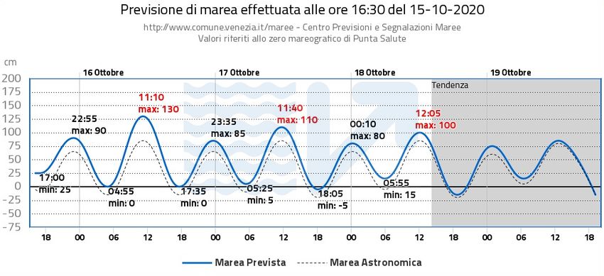
2684            G. Umgiesser et al.: The prediction of floods in Venice: methods, models and uncertainty (review article)

seiches, which have periods that are much smaller than the         a rare paper addressing the subject, the lack of interest was
inertial period and thus marginally influenced by the rotation     attributed to the small depth of the lagoon (the mean value
of the Earth.                                                      being close to 1 m) and the consequent strong damping of
   Investigation of Adriatic-wide seiches was pioneered by         local seiches (Zecchetto et al., 1997).
Kesslitz (1910), who inspected de-tided sea level records in          Mean sea level rise will affect Adriatic seiches and tides
time domain, by Vercelli (1941), who performed filtering of        depending on the adopted strategy of coastal defense (Li-
tide-gauge records, and by Bozzi Zadro and Poretti (1971),         onello et al., 2005; Haigh et al., 2020). If dams are built to
who subjected sea level time series through spectral analysis.     preserve the current coastline, increased wave speed and re-
These analyses, and their numerous sequels, showed that the        duced bottom friction will shorten the period of seiches and
amplitudes of Adriatic-wide seiches could reach 50 cm and          move it away from those of tides, whose amplitude would
that the periods of two basic modes are close to 21.2 and          be consequently reduced. On the contrary, if the Adriatic Sea
10.9 h. This seiche amplitude should be compared to the            will be allowed to freely expand over coastal areas, the period
maximum spring amplitude of 50 cm (Fig. 2). The periods            of seiches will become closer to those of tides, whose am-
were verified by applying numerical modeling to the Adriatic       plitude would be, consequently, increased. Changes in am-
Sea: one-dimensional (Sterneck, 1919) and two-dimensional          plitude will be on the order of 10 % for 1 m sea level rise,
(Accerboni and Manca, 1973) with nodal line imposed in the         increasing substantially for larger values.
Straight of Otranto and two-dimensional (Schwab and Rao,
1983) with the Adriatic being considered as a part of a wider
Mediterranean Sea. Numerical modeling expanded over the            4     Storm surge modeling
subsequent years, and, moreover, the question of generation
                                                                   In this section we describe existing storm surge modeling
and decay of the Adriatic seiches received some attention.
                                                                   systems for Europe. It gives an overview of the capabilities
Thus, Raicich et al. (1999) confirmed the sequence of events
                                                                   and the peculiarities of the various areas and their forecast
usually leading to the generation of basin-wide seiches: dur-
                                                                   systems. Finally, the forecasting systems for the Adriatic Sea
ing the first phase, a storm surge develops in the Adriatic
                                                                   and the Venice Lagoon will be discussed.
when a cyclone approaches the basin and thus exposes it to
                                                                      Common for all regional storm surge models is the depen-
a combined action of low air pressure and sirocco wind; dur-
                                                                   dency on high-quality (a) meteorological forecast data and
ing the second phase, seiches are triggered in the Adriatic
                                                                   (b) basin geography. The error growth of the weather forecast
when the cyclone leaves the basin, and therefore air pressure
                                                                   with time is ported directly to the storm surge forecast and
rises, while sirocco wind slackens or veers to bora. It was also
                                                                   dominates the error growth of the latter from analysis time
pointed out that the partition of energy between various nor-
                                                                   onwards. This is because the atmosphere behaves much more
mal modes depends on the spatial variability in sirocco wind
                                                                   chaotic than the sea. The storm surge model error at analy-
and the Adriatic bathymetry. Cerovečki et al. (1997) consid-
                                                                   sis time may be brought down by data assimilation and may
ered 12 pronounced episodes of basin-wide seiches and ob-
                                                                   be considerable without it. Ideally, systematic model errors
tained 3.2 ± 0.5 d for the free decay time. It was concluded
                                                                   are identified and minimized by applying analyzed weather
that the longevity of the Adriatic seiches could be ascribed
                                                                   forcing in a calibration procedure prior to operationalization.
to the weak influence of bottom friction and the small en-
ergy loss to the Mediterranean Sea. Due to their considerable      4.1     Storm surge modeling in Europe
amplitudes and persistence, the Adriatic-wide seiches could
influence the flooding of the north Adriatic coastal area: if a    4.1.1    The Atlantic coast
cyclone approaches the Adriatic while the seiches related to
the previous cyclone still last, a constructive or destructive     Storm surges increase northward along the European At-
superposition of the storm surge and the preexisting seiches       lantic coast (Vousdoukas et al., 2016; Fortunato et al., 2016)
may occur.                                                         due to the northward growth of both the storm intensity and
   Local seiches were also found to be important in the Adri-      the width of the continental shelf, from tens of kilometers
atic Sea. More specifically, the east Adriatic archipelago,        along the Iberian coast to a few hundred to the west of the
with its numerous bays and channels, represents an ideal           British Isles. Devastating storm surges are therefore more
setting for the development of short-period seiches. An            common in the north. For instance, coastal inundation lev-
overview of these waves, and of their importance in the gen-       els above 0.5 m occur about once a year in Ireland (O’Brien
eration of meteotsunamis, is provided by Vilibić et al. (2017).   et al., 2018). Although less frequent, catastrophic events also
Much less is known on local seiches along the west Adri-           occur on the French (Breilh et al., 2014) and Iberian (de Fre-
atic coast. Thus, for example, seiches may be expected to          itas and Dias, 2013) coasts.
occur in the Venice Lagoon with a period of 2–3 h defined             These events have fueled the development of forecasts of
by the length and depth of the basin. It appears, however,         tides and surges in the European Atlantic coasts (Fortunato et
that the existence of such seiches and their possible influence    al., 2017; Sotillo et al., 2019; Oliveira et al., 2020), although
on the flooding of Venice did not receive much attention. In       the implementation details are often unavailable. The Por-

Nat. Hazards Earth Syst. Sci., 21, 2679–2704, 2021                                 https://doi.org/10.5194/nhess-21-2679-2021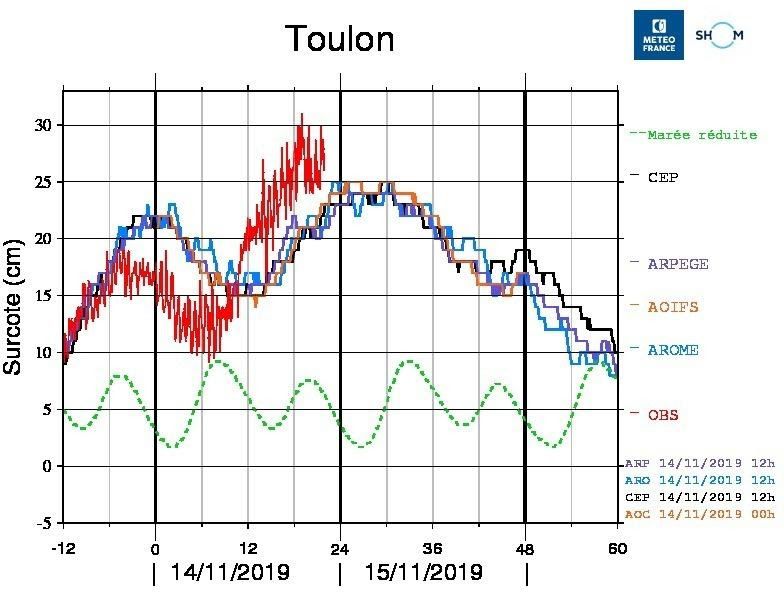
G. Umgiesser et al.: The prediction of floods in Venice: methods, models and uncertainty (review article)                      2685

tuguese Laboratório Nacional de Engenharia Civil produces             casts (ECMWF) to forecast storm tides (Saetra et al., 2018).
48 h forecasts of tides and surges using SCHISM (Zhang et             The Danish Meteorological Institute (DMI) runs two storm
al., 2016) in 2DH mode. The application is forced by the at-          surge models covering the North Sea and Baltic Sea to pro-
mospheric global forecast system (GFS; NCEP, 2011) and                vide storm tide forecasts for Danish Waters (Flather, 2000).
the global tidal model FES2012 (Carrère et al., 2013) with            In Germany, the Bundesamt für Seeschifffahrt und Hydro-
a grid resolution of about 250 m along the Portuguese coast           graphie (BSH) uses a nested storm surge model, forced with
(Fortunato et al., 2017). In Spain, Puertos del Estado runs           meteorological predictions from global and local area mod-
several forecasts, described in Sect. 4.4, while MeteoGalicia         els of the Deutscher Wetterdienst (DWD) to provide fore-
runs the Regional Ocean Modeling System (ROMS) at re-                 casts of water levels (Dick, 1997). In the Netherlands, wa-
gional scales, with nested applications of MOHID (Mateus              ter level forecasts are made by the Dutch storm surge warn-
et al., 2012) at estuarine scales. In France, Météo-France            ing service (SVSD) in close cooperation with the Royal
applies Hybrid Coordinate Ocean Model (HYCOM; Bleck,                  Netherlands Meteorological Institute (KNMI) (Verlaan et
2002) in two dimensions, with a curvilinear grid of resolution        al., 2005). These are based on the Dutch continental shelf
down to 500 m along the coast and a spatially varying bottom          model (DCSM) forced with forecasts from the meteorologi-
friction. The British Met Office uses the Nucleus for Euro-           cal high-resolution limited area model (HiRLAM). Since the
pean Modeling of the Ocean (NEMO) model (Madec and the                early 1990s, a Kalman filter has been used to improve the
NEMO team, 2016), with a spatial resolution of 7 km and a             accuracy of the forecasts by incorporating observations from
Charnock approach (Charnock, 1955) with a tuned Charnock              tide gauges. In the United Kingdom, the Coastal Monitor-
parameter to compute surface stress. A refinement to 1.5 km           ing and Forecasting (UKCMF) service was established as
and a wave-dependent approach to compute the surface stress           a direct result of the 1953 floods (Flather, 2000). Presently,
are currently under development.                                      the operational system uses the CS3X hydrodynamic model
   Simulations of tides and surges decoupled from waves are           (Flather, 1994), which has a resolution of ∼ 12 km, forced
still the norm (Fortunato et al., 2017; Fernández-Montblanc           with the Met Office’s Global and Regional Ensemble Predic-
et al., 2019), in particular in the routine predictions of official   tion System (MOGREPS).
forecasts. However, the importance of waves on sea levels is             In the future the CS3X model will be replaced with a
well-established (Dodet el al., 2019). The increased rough-           NEMO-surge tide model (O’Neil et al., 2016). Recently,
ness of the sea surface associated with steep young waves             Fernández-Montblanc et al. (2019) described efforts to create
can significantly increase the wind stress, thereby enhanc-           a pan-European storm surge forecasting system (EU-SSF).
ing wind-induced surge (Bertin et al., 2015). In addition, the        This uses the SCHISM (Semi-implicit Cross-scale Hydro-
wave-induced setup can contribute significantly to the over-          science Integrated System Model) unstructured grid model,
all surge along the coast, even in sheltered areas like estuaries     forced with atmospheric fields from ERA-Interim, as well as
(Lavaud et al., 2020). Hence, wave–current interactions will          by an ECMWF high-resolution forecast.
likely be increasingly included in forecast services. Also, the
hazards associated with high river flows and storm surges are         4.1.3   The Baltic Sea
usually treated separately, but recent efforts target the simu-
lation of flooding induced simultaneously by river discharges         The Baltic Sea is a large, elongated (∼ 1000 km), brackish,
and storm surges (Ye et al., 2020).                                   semi-enclosed estuary connected to the world ocean only
                                                                      via narrow and shallow straits. Baltic storm surges occur
4.1.2   The North Sea                                                 when the regional wind and atmospheric pressure conditions
                                                                      displace the water mass towards one far end of the basin
The North Sea has a long history of coastal flooding with sig-        (Samuelsson and Stigebrandt, 1996; The BACC II Author
nificant coastal flood events in 1099, 1421, 1446, 1530, 1570         Team, 2015). Surges may reach 2–2.5 m, but at least one
and 1717 (Haigh et al., 2017). In the last century, the “Big          event in excess of 3 m has been reported and studied (Rosen-
Flood” of 31 January–1 February 1953 and the flood of 16–             hagen and Bork, 2009). While the Baltic Sea is (almost) de-
17 February 1962 provided a major incentive for establishing          void of tides, standing waves (seiches) may occur. The “pre-
storm surge forecasting and warning services for North Sea            conditioning”, when a period of persistent North Sea wester-
countries and were the driving force for major improvements           lies may increase the Baltic mean sea level by up to 3/4 m
in sea defenses (Gilbert and Horner, 1986; Gerritsen, 2005).          (Hupfer et al., 2003), plays a crucial role. During the rela-
   Flather (2000) provided a review (now somewhat out-                tively short course of a high wind event, the Baltic water vol-
dated) of the operational systems used for real-time pre-             ume stays almost constant. Infrequently “silent surges” occur
diction of storm tides and waves in northwest Europe. The             when high winds over the central part of the basin may gen-
Norwegian Meteorological Institute (DNMI) uses a 4 km                 erate a storm surge at one basin end, under locally perfectly
resolution barotropic ROMS (Regional Ocean Modeling                   calm conditions. Under certain wind conditions, the peculiar
System) model, forced with ensemble weather predictions               shape of the far western Baltic leads to surges being built up
from the European Centre for Medium-Range Weather Fore-               from the north and the east simultaneously.

https://doi.org/10.5194/nhess-21-2679-2021                                    Nat. Hazards Earth Syst. Sci., 21, 2679–2704, 2021
2686 G. Umgiesser et al.: The prediction of floods in Venice: methods, models and uncertainty (review article)
For operational purposes, hydrodynamic storm surge mod- model average technique. The new solution is statistically
els of the Baltic often include part of or the entire North Sea. better than any of the individual members and includes a con-
A closed-basin (or parameterized boundary) model may be fidence band (Fig. 3).
chosen for theoretical studies. Some Baltic countries (Ger- Météo-France operational storm surge system: operational
many, Sweden and Denmark) have an extra-Baltic coastline since 2014 and developed by SHOM and Météo-France, it is
as well, and they apply a connected-seas system with locally based on a barotropic version of the HYCOM code (Pasquet
high resolution of the connecting straits, down to 1 km width. et al., 2014, 2017). The maximum resolution of the model
This may be accomplished, for example, by two-way nesting is 1.5 km. Tides are not included. The system is launched
or by unstructured grids. 15 times per day with different atmospheric forcing, allow-
The inclusion of thermodynamics, sea ice modeling, fresh ing the forecasters to assess the impact of each forcing on
water discharge from a vast catchment area and high verti- the sea level (Fig. 4). The model was validated with 22 storm
cal resolution establishes a realistic estuarine circulation and events and 1 year of data to calibrate the wind drag coeffi-
further improves sea level and surge simulation. cient (according to the Charnock formulation) (Casitas et al.,
High-resolution weather forcing from a limited area nu- 2018). Since 2016 an ensemble prediction system has been
merical weather prediction (NWP) model will generally pro- available, with 35 members of the Arpege Ensemble Fore-
duce an accurate sea level forecast a few days ahead, and it casting System as forcing, running at 06:00 and 18:00 UTC,
constitutes the basis for storm surge warnings in the region. with forecast horizons of 90 and 108 h respectively.
Less detailed, medium-range global weather forcing may be
used for pre-warning, when an alert is raised but no practical 4.2 The Adriatic Sea
action taken just yet.
Operational Baltic storm surge model codes include, Although scientific works on marine circulation in the Adri-
amongst others, the Baltic community model HBM (Berg atic Sea are very numerous and analyze it in detail, papers
and Poulsen, 2012) and the European NEMO model (Hor- presenting storm surge operational systems are few. Due to
doir et al., 2019; Madec and the NEMO team, 2016), the importance of Venice, many systems were developed
which constitute the model complex in the Copernicus in several operational Italian institutions. Meteotsunamis
Marine Service for the Baltic Sea and are also used for are also an important concern in the Adriatic Sea, which
national storm surge warning systems, typically accurate has motivated the recent development of dedicated ocean–
within 20 cm for 1–20 year events (Nielsen, 2003). A atmosphere modeling systems (Denamiel et al., 2019).
BOOS concerted forecast exchange forms the basis for The sea level in Venice has been recorded for more than
Baltic multimodel ensemble (MME) prediction (http://www. 100 years, and in this period there have been various ex-
boos.org/multi-model-ensemble-of-forecast-products/, last treme events, such as in 1966 (Cavaleri et al., 2010) and 1979
access: June 2021). (Grazzini, 2006), but almost every year events of a certain
intensity can happen (https://www.comune.venezia.it/node/
4.1.4 The western Mediterranean 6145, last access: June 2021), like in the last two years, 2018
and 2019 (Cavaleri et al., 2019, 2020). The following list
Forecasting sea level in this region is relevant to understand contains the storm surge forecasting systems in the Adriatic
phenomena and support activities with an important socioe- Sea, divided according to the institution in which they oper-
conomic impact, such as coastal erosion and inundation, in- ate:
frastructure damage, harbor operations, and navigation. Ex- The Institute of Marine Sciences (ISMAR) of Venice (Italy)
isting operational services in the region are as follows: is part of the National Research Council (CNR) and has been
Puertos del Estado storm surge system (Nivmar): opera- developing a hydrodynamic model called Shallow water HY-
tional since 1998 (Álvarez-Fanjul et al., 2001), it is based on drodynamic Finite Element Model (SHYFEM) for over 30
a two-dimensional barotropic implementation of the HAM- years. SHYFEM is an open-source finite element model
SOM model (Backhaus and Hainbucher, 1987). It is forced available on Github (https://github.com/SHYFEM-model/
with ECMWF 1/8◦ atmospheric pressure and wind fields. shyfem, last access: June 2021). This model has been used
Total sea level forecast is provided by adding the tidal signal many times for storm surge prediction, and many of the fol-
derived from measurements. A nudging technique makes use lowing operational systems are based on it.
of near-real-time tide gauge data to improve low frequency Kassandra: this system forecasts the total sea level and
signals. More recently, a new multimodel ensemble forecast waves in the Mediterranean and the Black seas (Ferrarin et
has been developed (Pérez-Gómez et al., 2012) combining al., 2013). The system is based on the SHYFEM model, cou-
the Copernicus Marine Environmental Service (CMEMS) pled to the wind wave model II (WWMII), and the fore-
operational models IBI-MFC (Sotillo et al., 2015) and MED- cast is available online (http://kassandra.ve.ismar.cnr.it:8080/
MFC (Clementi et al., 2019) (see description on Adriatic sec- kassandra, last access: June 2021). The resolution is variable
tion) with the Nivmar solution (Pérez-González et al., 2017, but remains around 5 km throughout the Mediterranean and
2019). The forecast is generated by means of a Bayesian 1 km along the Italian coast. The model considers both the
Nat. Hazards Earth Syst. Sci., 21, 2679–2704, 2021 https://doi.org/10.5194/nhess-21-2679-2021G. Umgiesser et al.: The prediction of floods in Venice: methods, models and uncertainty (review article) 2687
Figure 3. Sea level forecasted at Barcelona on 7 June 2020 (hourly time series): black: BMA solution (shaded area: 95 % uncertainty band
based on the output of the different models); blue: tide gauge observations; orange: tide. The BMA solution is obtained by combining the
sea level solutions from IBI-MFC, MED-MFC and Nivmar at Barcelona harbor (as displayed in PdE Portus system: https://portus.puertos.es,
last access: June 2021).
the SHYFEM model, is focused on storm surge prediction. It
operates with a computational grid, extended to the Mediter-
ranean, with a lower resolution in order to reduce calculation
times. Furthermore, the astronomical tide is not simulated but
added locally where a total sea level forecast is needed. Al-
though the simulation is barotropic and in two dimensions,
the accuracy on the sea level is not affected. A second two-
dimensional barotropic simulation is carried out in cascade
to the first one to extend the forecast into the Venice Lagoon,
using the forecast of the Mediterranean simulation with tide
(Ferrarin et al., 2020). Finally, a slower three-dimensional
baroclinic simulation is performed in the lagoon, using the
same grid of the second simulation, in order to predict the
temperature and salinity too. In this last simulation the tem-
perature and salinity boundary conditions are retrieved by the
Copernicus Marine Service.
Figure 4. Temporal series (every 10 min) for the storm surge fore- The Centro Previsioni e Segnalazioni Maree (CPSM) is
casted at Toulon (south of France) starting on 14 November 2019 at in charge of sea level forecasts and warning and is part of
12:00 UTC using the forcing provided by the global model IFS from the municipality of Venice (Italy). This center has the task of
ECMWF (named CEP, black), by the global model ARPEGE from
issuing the official forecast, with updates sometimes hourly,
Météo-France (purple), by the Météo-France LAM model AROME
and alerting the population using sirens scattered throughout
nested in ARPEGE (AROME) (blue) and by the Météo-France
LAM model AROME-IFS nested in IFS (orange). Red: tide gauge the inhabited centers in the lagoon. An example of the daily
observations; green: tide height (normalized). forecast page is given in Fig. 5. Statistics of the operational
forecast in CPSM have also been published (Zampato et al.,
2016).
The operational model at CPSM is called SHYMED
astronomical contribution to the sea level, with the calcula-
(SHYFEM on MEDiterranean). This system, based on the
tion of the gravitational potential, and the wave setup, thanks
SHYFEM model, updates previous systems that are no
to the two-way coupling with the wave model.
longer operational (Bajo et al., 2007, Bajo and Umgiesser,
Tiresias: this system, based on the SHYFEM model, uses
2010). Its structure is similar to ISSOS without the baro-
a baroclinic formulation of the shallow water equations and
clinic simulation but uses different atmospheric forcing. In
is therefore able to predict the temperature and salinity. The
addition, there are three versions with various wind stress
system extends to the whole Adriatic Sea and includes, in a
formulations and different corrections of the forecast wind.
single grid, the main lagoons (including the Venice Lagoon)
The forecast is emitted every 12 h, but every hour the fore-
and the Po delta (Ferrarin et al., 2019). This peculiarity al-
cast is updated by means of a one-dimensional Kalman filter,
lows for the reproduction of effects such as the saline wedge
using the latest observations (Bajo, 2020).
intrusion in the Po delta and the water circulation in three
Two other models were operational at CPSM. These were
dimensions in the Adriatic.
HYPSE, a two-dimensional finite difference model running
Ismar Storm Surge Operational System (ISSOS): com-
over the Adriatic Sea with assimilation of one sea level sta-
pared to the two previous systems, ISSOS, also based on
https://doi.org/10.5194/nhess-21-2679-2021 Nat. Hazards Earth Syst. Sci., 21, 2679–2704, 20212688 G. Umgiesser et al.: The prediction of floods in Venice: methods, models and uncertainty (review article) Figure 5. An example of the daily bulletin published on the official forecasts website of CPSM – Venice Municipality. The chart shows a 4 d forecast plus 1 d forecast trend. The water level refers to the Punta Salute datum, the historical zero of Venice defined in the year 1897. The blue line is the total expected sea level, and the dotted black line indicates the astronomical tide. tion (Lionello et al., 2006), and a system based on Delft-3D. Copernicus Marine Environmental Service (CMEMS) is Both systems are not operational anymore and have been de- the marine section of the European Copernicus program. commissioned. This program provides remote sensing and modeling data The Italian National Institute for Environmental Protec- freely available on the web (https://marine.copernicus.eu/, tion and Research (ISPRA) is an institution under the um- last access: June 2021). The modeling product for the brella of the Italian Ministry of Environment. The mod- Mediterranean Sea is called Med-MFC Analysis and Fore- eling system SIMM (Sistema Idro-Meteo-Mare) is a chain casting Physical System (MedFS). MedFS is a coupled of operational systems that includes the atmosphere, waves hydrodynamic-wave (NEMO-WW3) system (Clementi et al., and storm surge predictions (Speranza et al., 2007; Mar- 2017a, b) with a data assimilation component (Storto et al., iani et al., 2015). The storm surge forecasting system is 2015). The horizontal grid resolution is 1/24◦ with 141 verti- based on the SHYFEM model, which is set to execute two- cal levels. The model solves the three-dimensional baroclinic dimensional barotropic simulations. There are different ver- shallow water equations without the tidal component. Only sions that use different spatial resolutions, meteorological the surge component is published at the web site. forcings and data assimilation (DA). The version with DA Slovenian Environmental Agency (ARSO) is part of the is based on the dual 4D-Var technique (Bajo et al., 2017) and Slovenian Ministry of the Environment and Spatial Plan- assimilates sea level data from nine tide gauges along the ning. SMMO is a forecasting system based on the Aladin Italian Adriatic coast. atmospheric model and originally on the Princeton Ocean Arpae is the Regional Agency for Prevention, Environ- Model (POM), with a regular resolution of 1/30 of a degree. ment and Energy of Emilia-Romagna (Italy). The Hydro- Its computational domain is limited to the Adriatic Sea (Ličer Meteo-Climate Service of Arpae (Arpae-SIMC) actively et al., 2016). The system has been recently upgraded to the works in numerical model forecasting, both deterministic and NEMO ocean model with a resolution of 1/216 of a degree probabilistic, at different timescales from very short-range, in (Matjaž Ličer, personal communication, 2020). the case of extreme events, to seasonal scale. Arpae-SIMC is Consorzio Venezia Nuova (CVN) is the Italian consortium a center of competency for the Italian National Civil Protec- of companies responsible for building the Venice flood bar- tion system, as well as the support center for the Civil Pro- rier system, named MOSE. They are also running a fore- tection Agency of Emilia-Romagna. casting system for the operation of the mobile barriers. The The integrated modeling system developed by Arpae- storm surge model at CVN is developed by DHI and is SIMC for its marine and coastal activities (Fig. 6) con- based on Mike 21 (Vieira et al., 1993). Data from two at- sists of a wave-forecasting operational chain called MED- mospheric models are used (ECMWF and COSMO 5M). ITARE (Valentini et al., 2007) and AdriaROMS (Chiggiato The modeling chain consists of a Mediterranean model that and Oddo, 2008; Russo et al., 2013), which uses the ROMS drives an Adriatic Sea model and in turn the Venice La- model implemented in the Adriatic Sea (Shchepetkin and goon model. The forecasting period varies between 18 h and McWilliams, 2005). Both systems are forced by the non- 5 d (https://www.mosevenezia.eu/control-room/, last access: hydrostatic limited-area COSMO-I meteorological model June 2021). The output of this forecasting system is not made (Schättler et al., 2018). public. Nat. Hazards Earth Syst. Sci., 21, 2679–2704, 2021 https://doi.org/10.5194/nhess-21-2679-2021
G. Umgiesser et al.: The prediction of floods in Venice: methods, models and uncertainty (review article)                 2689

Figure 6. The operational modeling system and the meteo-marine products provided by Arpae-SIMC.

   Many of the aforementioned models have been considered          tem based on the finite element model SHYFEM (Bajo et al.,
together in the I-STORMS multimodel system (Ferrarin et            2007). The system, named SHYMED (see Sect. 4.5), is im-
al., 2020), which provides ensemble forecasts for water lev-       plemented on the whole Mediterranean and uses atmospheric
els and waves in the Adriatic and Ionian seas.                     forcing from ECMWF and sea level boundary conditions
                                                                   from Copernicus. A second simulation inside the lagoon uses
4.3   The Venice Lagoon                                            the forecast of the first simulation and the tide recorded at
                                                                   the oceanographic tower Acqua Alta, 8 nautical miles off the
Forecasting of storm surge events is mainly done in the Adri-      Venetian coast. In its actual implementation the model does
atic Sea as described in the last section. In order to resolve     not use assimilation techniques. However, the model results
also the tidal and storm surge propagation inside the lagoon       inside the lagoon were corrected with a neural network ap-
high-resolution models have to be run inside the Venice La-        proach in the past (Bajo and Umgiesser, 2010) and now with
goon. This can be done either in a traditional way, in which       a unidimensional Kalman filter (Bajo, 2020), which allows
the water levels computed outside the lagoon with models           hourly updates of the forecast.
running on the Adriatic Sea are used to force a new model             At ISPRA, another implementation of the SHYFEM
with a modeling domain resolving only the lagoon area, or a        model (SIMM) is running daily (Mariani et al., 2015). This
combined model with a domain including both the Adriatic           application uses wind both from ECMWF and from an-
Sea and the Venice Lagoon. Both types of approaches are            other atmospheric model (BOLAM, Bologna Limited Area
used in Venice and are described below. Moreover, statistical      Model), produced by ISPRA in Rome. A version of this im-
models are also used for forecasting.                              plementation uses a dual 4D-Var assimilation technique for
   The CPSM has been running, for a long time (from 1981),         which nine tide gauges in the Adriatic are used. Also in this
statistical models that use the atmospheric pressure, wind and     case, a new model run propagates the water level inside the
water level data from past events to forecast the new events       lagoon and publishes water levels for some important islands
in the future. Especially for the short time range (up to 12 h)    inside the lagoon, such as Venice, Burano and Chioggia.
this is quite effective. These models will be presented in the        At the CNR the ISSOS storm surge model is running. As
next section.                                                      the implementations of the models in CPSM and ISPRA, the
   Concerning deterministic models that actually resolve the       model first resolves the Mediterranean Sea and then com-
physics of the surge propagation, one of the first models          putes the water levels in a second run inside the lagoon. A
that was implemented at the CPSM was a forecasting sys-

https://doi.org/10.5194/nhess-21-2679-2021                                Nat. Hazards Earth Syst. Sci., 21, 2679–2704, 2021
2690 G. Umgiesser et al.: The prediction of floods in Venice: methods, models and uncertainty (review article)
lagoon run of this model is baroclinic, therefore taking also claimed areas are located, all situated below the mean sea
into account temperature and salinity (Ferrarin et al., 2020). level.
There is one model (Tiresias, Ferrarin et al., 2019) that is According to literature, an average difference of 50 cm
implemented on a numerical grid that comprises the whole has been estimated between the northern and southern part
Adriatic Sea and the Venice Lagoon. With this model, water of the lagoon (Fig. 7) in different cases of bora wind of 5–
levels are directly computed at the stations inside the lagoon, 7 m s−1 (Pirazzoli, 1981; Berrelli et al., 2006) and higher dif-
and there is no need to run a second model to propagate this ference in cases of extreme meteorological events (Cordella
information inside the lagoon. and Ferla, 2007). Such phenomena were observed mainly
in February during the years 2012, 2014 and 2015 when a
strong bora wind was blowing (ISPRA, 2012; Coraci and
Crosato, 2014). As already mentioned in Sect. 3.2, sirocco
5 Challenges in forecasting flooding for the Venice winds (southeasterly) push water masses towards the Venice
Lagoon Lagoon. The combination of all these local effects and cli-
mate change (Rinaldo et al., 2008) could lead to severe and
Here we stress the peculiarity of Venice for water level fore- disastrous storm surge events, as has happened during the
casting. We show what deterministic and statistical forecast last 2 years (October 2018, November 2019; Morucci et al.,
models can do and how they complement themselves. We 2020; AAVV, 2020).
also discuss the importance of assimilation for improvement
of the forecast and ensemble methods for the estimation of 5.2 Deterministic forecast models
the uncertainty. We then also give some examples of past
storm surge events. The deterministic operational models for predicting the sea
level in Venice are typically storm surge models which solve
5.1 Local effects shallow water equations in two or three dimensions. This
simplified formulation is often used instead of more complex
The Venice Lagoon has experienced significant subsidence equations as it is extremely fast and has an accuracy compa-
effects (Baldin and Crosato, 2017; Carbognin et al., 2004) rable to more complex equations in storm surge resolution.
in the last century and is constantly exposed to the risk of Many operational systems based on deterministic models
flooding from storm surge, enhanced also through relative use computational domains extended to the whole Mediter-
sea level rise (Frassetto, 2005). The semi-closed shape of the ranean Sea even if some of them run only the Adriatic Sea.
Adriatic Sea favors the occurrence of intense storm surge However, the extension to the Mediterranean Sea avoids
events, and the sea level rises to unusual values because of problems in the reproduction of the seiches, which have a
the local low-pressure system cyclogenesis (Genoa) and as- nodal point near the Strait of Otranto (Cerovečki et al., 1997).
sociated strong winds driven by orography. It is well-known The lateral boundary conditions of sea level and, sometimes,
that the hydrodynamics of the Venice Lagoon is strongly de- water flux can be retrieved by other operational models,
pendent upon both tides and prevalent local wind regimes such as those of the European Copernicus Programme (https:
(Berrelli et al., 2007). //marine.copernicus.eu/, last access: June 2021). The surface
The level at the Punta della Salute tide gauge (Venice cen- boundary conditions are the most important for a storm surge
ter) is not enough to widely represent the conditions of the la- model and consist of wind and atmospheric pressure fields.
goon basin during occurrences of storm surge (Ferla, 2005). Due to the orographic conformation around the Adriatic Sea,
Sea level observations have shown that the forcing action atmospheric models tend to have large errors, and local-scale
of the wind along the lagoon surface gives rise to consid- models with high resolutions may be required.
erable accumulations on the water against the southern or Deterministic models can include the tidal potential in
northern boundaries of the lagoon, depending on the wind their equations and thus simulate the propagation of the as-
direction. The maximum water levels are significantly dif- tronomical tide. However, operational systems prefer to sim-
ferent in Venice and in other larger inhabited centers, such ulate only the storm surge component and locally add the as-
as Chioggia in the southern section of the lagoon or Burano tronomical tide, calculated through harmonic analysis, since
in the northern portion. Under these varying weather condi- the interactions between storm surge and tidal components
tions, sea level differences between the various parts of the are small in the northern Adriatic (see Lionello et al., 2021b,
lagoon and especially between lagoon and sea can determine in this special issue for a short discussion).
asymmetrical hydrodynamic conditions at the inlets. Others possible problems in the Adriatic Sea concern the
Local surges, mainly due to wind setup, have a scale of complexity of the coasts and the need to adequately repre-
a few kilometers inside the Venice Lagoon and can produce sent them (for this purpose it is better to use models with un-
significant effects, especially near the lagoon borders; bora structured grids), as well as the lack of high-resolution and
wind (northeasterly) has relevant effects in the southern la- accurate bathymetric datasets in the continental shelf border.
goon, near Chioggia island, where fishing valleys and re- Finally, forecast scores can further be improved through the
Nat. Hazards Earth Syst. Sci., 21, 2679–2704, 2021 https://doi.org/10.5194/nhess-21-2679-2021You can also read