Taynuilt West Region Taynuilt Land Management Plan 2020 2029 - Forestry and Land Scotland
←
→
Page content transcription
If your browser does not render page correctly, please read the page content below

Taynuilt Land Management Plan 2020 – 2029

West Region

Taynuilt
Land Management Plan

Approval date: ***

Plan Reference No: ****

Plan Approval Date: *****

Plan Expiry Date: ******

1   |   Taynuilt LMP       |   Ian Thomas   |   October 2019

Taynuilt Land Management Plan 2020 – 2029

FORESTRY AND LAND SCOTLAND
Application for Land Management Plan Approvals in Scotland
Forestry and Land Scotland - Property
Region:                       West
Woodland or property name:    Taynuilt (Comprising Fearnoch, Glen Nant &
                              Inverawe)
Nearest town, village or      Taynuilt
OS Grid reference:            Fearnoch (NM 965 305); Glen Nant (NN 006 287);
                              Inverawe (NN 034 319).
Local Authority district/unitary     Argyll & Bute Council

Areas for Approval             Conifer Ha   Broadleaf        Open       Other    Peatland
                                                             Space      Land    Restoration
Clear felling                   366.30
Restocking                      256.84                       22.32
Selective Fell                   8.49
Natural Regeneration                            368.13

Note: restock includes areas felled under previous Plan (280.99Ha).
Natural Regeneration will be the preferred option for PAWS restoration. The progress of
regeneration will be monitored and planting may be required to achieve desired species
and stocking densities. Areas of productive broadleaves are proposed for some PAWS
areas in Fearnoch and these would be established by planting appropriate species of
local provenance as well as natural regeneration. The areas selected for productive
broadleaves will be identified post felling.
1. I apply for Land Management Plan approval for the property described above and
in the enclosed Forest Plan.
2. * I apply for an opinion under the terms of the Environmental Impact
Assessment (Forestry) (Scotland) Regulations 1999 for road building as
detailed in my application.
3. I confirm that the initial scoping of the plan was carried out with FC staff in
   2018/2019.
4. I confirm that the proposals contained in this plan comply with the UK
   Forestry Standard.
5. I confirm that the scoping, carried out and documented in the Consultation
   Record attached, incorporated those stakeholders which the FC agreed must
   be included.
6. I confirm that agreement has been reached with all of the stakeholders over
   the content of the forest plan and that there are no outstanding issues to be
   addressed. Copies of consultee endorsements of the plan are attached.

2   |    Taynuilt LMP      |       Ian Thomas     |      October 2019
Taynuilt Land Management Plan 2020 – 2029

7. I undertake to obtain any permissions necessary for the implementation of
   the approved Plan.

Signed    ………………………………                   Signed…………………………………………………
         PP Regional Manager                    Conservator

Region: West                             Conservancy:   Perth & Argyll

Date:                                    Date of Approval: ………………………….

                                         Date approval ends:      …………………….

3   |    Taynuilt LMP   |   Ian Thomas    |   October 2019
Taynuilt Land Management Plan 2020 – 2029

4   |   Taynuilt LMP   |   Ian Thomas   |   October 2019

Taynuilt Land Management Plan 2020 – 2029

5   |   Taynuilt LMP   |   Ian Thomas   |   October 2019
Taynuilt Land Management Plan 2020 – 2029

6   |   Taynuilt LMP   |   Ian Thomas   |   October 2019

Taynuilt Land Management Plan 2020 – 2029

Contents
1.0 Summary

2.0 Legal and Regulatory Requirements
    2.1   Summary of planned operations
    2.2   Proposed felling in years 2020-2029
    2.3   Proposed thinning in years 2020 – 2029
    2.4   Proposed restocking in years 2020 – 2029
    2.5   Access and roading 2020 – 2029
    2.6   Other Projects
    2.7   Departure from UKFS Guidelines
    2.8   Tolerance table

3.0 EIA Screening Determination
    3.1   Proposed   removal of woodland
    3.2   Proposed   new roads and upgrading of roads
    3.3   Proposed   quarries
    3.4   Proposed   woodland creation

4.0 Introduction
    4.1 The existing land holding
    4.2 Setting and context
    4.3 Plan Presentation

5.0 Whole Plan Objectives
    5.1 Whole plan management objectives
    5.2 Analysis
    5.3 Implementation of whole plan objectives

6.0 Introducing the Management Zones

7   |     Taynuilt LMP     |    Ian Thomas    |   October 2019
Taynuilt Land Management Plan 2020 – 2029

7.0 Fearnoch Management Zone
    7.1 Issues
    7.2 Key Challenges
    7.3 Management Objectives
    7.4 Felling & Continuous Cover Forestry (CCF) Proposals
    7.4.1 Clear Felling
    7.4.2 Thinning
    7.4.3 Continuous Cover Forestry (CCF)
    7.5 Future Habitats & Species
    7.6 Management of open land
    7.7 Natural Reserves

8.0 Glen Nant Management Zone
    8.1 Issues
    8.2 Key Challenges
    8.3 Management Objectives
    8.4 Felling & Continuous Cover Forestry (CCF) Proposals
    8.4.1 Clear Felling
    8.4.2 Thinning
    8.4.3 Continuous Cover Forestry (CCF)
    8.5 Future Habitats & Species
    8.6 Management of open land
    8.7 Natural Reserves

9.0 Inverawe Management Zone
    9.1 Issues
    9.2 Key Challenges
    9.3 Management Objectives
    9.4 Felling & Continuous Cover Forestry (CCF) Proposals
    9.4.1 Clear Felling
    9.4.2 Thinning
    9.4.3 Continuous Cover Forestry (CCF)
    9.5 Future Habitats and Species
    9.6 Management of open land
    9.7 Natural Reserves

10.0 Long Term LMP Proposals

8   |   Taynuilt LMP    |   Ian Thomas     |    October 2019
Taynuilt Land Management Plan 2020 – 2029

11.0 Critical Success Factors

12.0 Management Prescriptions
     12.1 Forest Management Types
     12.2 Thinning
     12.3 Future Habitats & Species
     12.4 Operational Access
     12.5 Deer Management
     12.6 Open Ground Management
     12.7 Public Access & Core Paths
     12.8 Heritage Features
     12.9 PAWS Restoration
     12.10 New Woodland Creation

Appendices
Appendix I: Assessment of success of previous plan

Appendix II: Background information
II/ 1.0 Physical site factors
    1.1 Geology Soils and landform
    1.2 Climate
    1.3 Water

II/2.0 Current land management
     2.1 The existing forest
            2.1.1 Species, age structure and yield class
            2.1.2 Access and roading
            2.1.3 CCF potential

     2.2 Biodiversity and environmental designations
             2.2.1 Habitats and species
             2.2.2 Riparian habitat

9   |    Taynuilt LMP    |      Ian Thomas   |    October 2019
Taynuilt Land Management Plan 2020 – 2029

               2.2.3 Invasive species
               2.2.4 Pests and diseases

      2.3 Landscape, landscape designations and visibility
             2.3.1 Landscape Character
             2.3.2 Visibility & Viewpoints

      2.4 Social factors
            2.4.1 Recreation
            2.4.2 Community
            2.4.3 Heritage

      2.5 Statutory requirements and key external policies

Appendix III: Consultation record

Appendix IV: Supplementary Information

Appendix V: Fearnoch PAWS & LMP Advisory Note

Appendix VI: DMP & Fencing Proposals

Appendix VII: Phase 1 & 2 Coupe Details

Support documents: Maps

Map   M1:   Location & Viewpoints
Map   M2:   Felling within first ten years of Plan
Map   M3:   Thinning within first ten years of Plan
Map   M4:   Restocking within first ten years of Plan
Map   M5:   Landscape Scale Opportunities & Constraints
Map   M6:   Ancient Semi-Natural Woodland Distribution

Map M7a & b: Fearnoch Current Species (Note: Fearnoch is split into 2 maps, a north &
south section)
Map M8a & b: Fearnoch Current Age Class
Map M9a & b: Fearnoch Opportunities & Constraints
Map M10a & b: Fearnoch Design Concept
Map M11a & b: Fearnoch Management
Map M12a & b: Fearnoch Future Habitats & Species

10     |     Taynuilt LMP    |   Ian Thomas     |   October 2019
Taynuilt Land Management Plan 2020 – 2029
Map M12c & d: Fearnoch Productive NBL Search Areas
Map M13: Glen Nant Current Species
Map M14: Glen Nant Current Age Class
Map M15: Glen Nant Opportunities & Constraints
Map M16: Glen Nant Design Concept
Map M17: Glen Nant Future Habitats & Species
Map M18: Inverawe Current Species
Map M19: Inverawe Current Age Class
Map M20: Inverawe Opportunities & Constraints
Map M21: Inverawe Design Concept
Map M22: Inverawe Management
Map M23: Inverawe Future Habitats & Species
Map M24: Roads & Infrastructure
• 3D Visualisations
Inverawe from the north shore of Loch Etive
11 | Taynuilt LMP | Ian Thomas | October 2019Taynuilt Land Management Plan 2020 – 2029
1: Summary
The Taynuilt Land Management Plan (LMP) area covers 2041 Ha, and comprises 3
discrete blocks: Fearnoch(1289Ha), Glen Nant (332Ha) & Inverawe(420Ha). See
Map below for location.
While lying in close proximity to each other the three blocks have very distinctive
features and are considered as three distinct zones for planning purposes within
the plan.
Land Management Plan(LMP) Location
Fearnoch is a well roaded, mixed aged, mixed species forest containing a wide
range of soil types. Restructuring has taken place across the full extent of the
forest. The terrain is gently rolling which benefits harvesting operations and
reduces landscape impacts. The forest is a very popular recreational area. Clais
Dhearg SSSI lies to the West of the forest & Airds Park & Coille Nathais SSSI lies
to the East. Both SSSIs also fall within the wider Loch Etive Woods SAC. There are
12 | Taynuilt LMP | Ian Thomas | October 2019Taynuilt Land Management Plan 2020 – 2029 extensive PAWS areas in Fearnoch which often occupy highly productive sites carrying mixed conifers. Part of the forest falls within the catchment of the Oban water supply. Glen Nant is a National Nature Reserve managed in partnership with SNH. It is also a Caledonian Forest Reserve and an SSSI. The woodland comprises a matrix of mature native woodland and clear felled conifer areas that are being restored to native woodland by natural regeneration. Glen Nant has a very high ecological value as Atlantic Oakwood habitat and enhances the aesthetics of the roadside landscape when viewed from the B845 which runs along the edge of the woodland. Wider landscape impacts are limited and recreational use is modest. Much of the site is classed as a Natural Reserve. Inverawe has a very high visual impact from a range of villages and tourist routes. The forest comprises a mix of productive conifers and native broadleaves. The Barran Dubh SSSI lies within the NE side of the woodland. Restoration of the SSSI area to native woodland is largely complete. There are significant areas of quality mature hardwoods and policy type mixed conifer plantings along the northern edge of the forest. Access to these mature broadleaves is constrained. A small area of mature mixed species woodland between the public road and the River Awe is the subject of a potential Community acquisition. The forest was established with timber production as a priority and timber production remains an important objective today, however extensive felling and replanting has created a more diverse forest structure with a wider range of species, and this helps to deliver multi-purpose benefits. The forest is FSC certified and the management will seek at all times to meet the UK Woodland Assurance Standard. This LMP builds on the diverse structure created by previous forest plans. The core issue for each woodland block can be summarised as: Fearnoch: PAWS restoration and enhancing adjacent designated sites. Glen Nant: Maintenance and monitoring of PAWS restoration areas. Inverawe: Landscape and enhancing the SSSI. The plan presents felling and replanting proposals for the first ten years (2020 to 2029) in detail. Forest road and track formation during this period are also detailed. The first ten years are important because this relates to the parts of the plan that seeks approval for specific forestry operations. These are set out in Section 2 of this plan. 13 | Taynuilt LMP | Ian Thomas | October 2019
Taynuilt Land Management Plan 2020 – 2029
The following ten years (post 2029) and beyond are also considered in the plan to
indicate a direction of travel and to provide context. These long term plan proposals are
set out in the maps associated for each individual zone (see below).
Because the plan area is large and there are areas with very different characteristics,
the plan area has been divided into three management zones, identified because of
their common characteristics, issues and challenges, and the plan is presented on this
basis.
Objectives
Plan objectives for have been identified, and these are related to each zone in Section
5.
The plan objectives are:
Protect and enhance designated conservation sites within & adjacent to the LMP
area.
Restore PAWS areas to create wider landscape scale native woodland linkages.
Timber production from a wide range of conifer species with the emphasis on
matching species with site.
Evaluate the PAWS restoration areas for productive broadleaves.
Enhance the landscape by coupe design and restocking proposals.
Maintain and enhance the recreational infrastructure.
Maintain & enhance water quality in relation to both private and public water
supplies and the Loch Etive shellfish growing area.
Reduce the occurrence risk and potential impacts of Phytophthora ramorum by
felling Larch areas at the earliest feasible opportunity.
14 | Taynuilt LMP | Ian Thomas | October 2019Taynuilt Land Management Plan 2020 – 2029
Summary of management proposals
The felling proposals in the first twenty years of the plan can be summarised as
follows:
Area
Felling Ha %
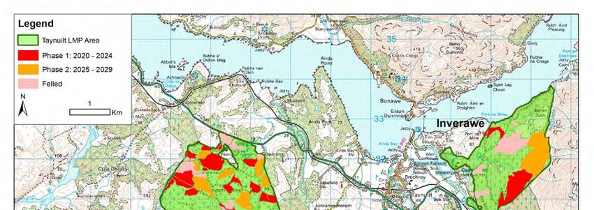
Phase 1: 2020 - 2024 230 11%
Phase 2: 2025 - 2029 136 7%
Phase 3: 2030 - 2034 149 7%
Phase 4: 2035 - 2039 161 8%
Total 676 33%
See Maps associated with each Zone (Feranoch/Glen Nant/Inverawe) in the main map
section for felling proposals across the next 20 years and beyond. The first two felling
phases are shown below as these would be the approved felling areas for this plan,
with subsequent felling approvals being the subject of a plan review at year 10.
Felling Phases 2020 to 2029 (includes Felled Ground)
The species composition over the first twenty years changes over time as follows:
15 | Taynuilt LMP | Ian Thomas | October 2019Taynuilt Land Management Plan 2020 – 2029
Species Species Species Species Species %
Group @ Group Group @ Group Group Species Change
2020 Area @ 2020 2029 @ 2029 @ 2039 Group @ 2020 to
Species Group Ha % Area Ha % Area Ha 2039 % 2039
Felled 281.33 15%
Mixed
Broadleaves 76.35 4% 82.67 4% 85.22 4% 0%
Diverse
Conifers 184.99 9% 196.75 10% 161.33 8% -1%
Native
Broadleaves 294.75 14% 675.88 33% 854.60 42% 28%
Open Ground 275.51 12% 274.48 13% 249.37 12% 0%
Sitka Spruce 928.17 45% 811.32 40% 690.59 34% -11%
Total 2041.10 100% 2041.10 100% 2041.10 100%
Restocking 2020 to 2029 (includes Phase 1 & 2 fellings, previously felled land, PAWS
restoration areas by Natural Regen, and some integral open ground)
16 | Taynuilt LMP | Ian Thomas | October 2019Taynuilt Land Management Plan 2020 – 2029
The biggest change in species composition relates to the proposed reduction of Sitka
Spruce and the increase in broadleaves as part of the PAWS restoration. Note that the
felled area relates to significant PAWS restoration already underway in Glen Nant,
Inverawe and Fearnoch.
New roading includes 1343m of new road in Inverawe to access the standing timber on
the upper part of the site (a Prior Notification has been submitted). Two new road
extensions of 695m in total are proposed to reach areas of Phase 1 timber in Fearnoch
that are currently landlocked, and these extensions will require a Prior Notification.
Overall, the operations planned for the forest during the period 2020 – 2029 include
the following activities:
Planned operations 2020 – 2029 plan period
Felling 366Ha
Thinning 1120Ha
Restock/Regeneration 670Ha
New woodland creation 0Ha
Road Construction 2053m
ATV Track Construction To be identified post felling
Quarry Existing
Note: Restock area includes areas already felled & awaiting restocking. These totals include
extensive PAWS restoration areas already underway including 117Ha in Glen Nant & 31Ha in
Inverawe.
Note: Road Construction & ATV Track Construction outwith the existing road/track footprint
require Prior Notification.
17 | Taynuilt LMP | Ian Thomas | October 2019Taynuilt Land Management Plan 2020 – 2029
Consultation & further Information
During the development of this plan we have consulted with the local
community and other stakeholders. For further information on the plan
please contact:
Donald McNeill
Planning Manager
Forestry & Land Scotland
West Region
Millpark Road
Oban
PA34 4NH
or
Whitegates
Lochgilphead
PA31 8RS
Tel: (Lochgilphead office) 0131 370 5200
Tel: (Fort William office) 0131 370 5700
email: enquiries.west@forestryandland.gov.scot
donald.mcneill@forestryandland.gov.scot
Note: LMP presentation.
The Taynuilt LMP has been set out as follows:
Sections 1 to 5 cover the whole plan area.
Section 6 introduces the three management zones in the plan.
Sections 7, 8 & 9 then considers each of the management zones in detail.
Sections 10, 11, 12 relate to the full plan area.
The Appendices relate to the full plan area.
18 | Taynuilt LMP | Ian Thomas | October 2019Taynuilt Land Management Plan 2020 – 2029
2.0: Legal and Regulatory Requirements
The Taynuilt Land Management Plan (LMP) area covers 2041 Ha as shown on Map
M1 Location & Viewpoints
2.1 Summary of planned operations
Details of individual Phase 1 & 2 coupes in terms of felling/restocking & thinning
are included in appendix VII. The operations planned for the Taynuilt LMP during
the period 2020 – 2029 include the following activities:
Planned 2020 – 2029 % of
operations plan period woodland
area
Felling 366Ha 18
Thinning 1120Ha 55
Restock & 670Ha 33
Regeneration
New woodland
creation
Road Construction 2053m
ATV Track
Construction
Quarry
Note: Restock area includes areas already felled & awaiting restocking. These totals include
extensive PAWS restoration areas already underway including 117Ha in Glen Nant & 31Ha in
Inverawe.
Note: Road Construction & ATV Track Construction outwith the existing road/track footprint
require Prior Notification. Proposed road construction in Inverawe (1343m) has already been
assessed/consented. EIA screening request & Prior notification required for 710m of new road
in Fearnoch.
2.2 Proposed Felling in years 2020-2029
Appendix VII shows details of individual felling coupes within phase 1 & Phase 2.
19 | Taynuilt LMP | Ian Thomas | October 2019Taynuilt Land Management Plan 2020 – 2029
As shown in map M2 Felling within first ten years of Plan, it is proposed that 11%
of the forest area will be felled between 2020 and 2024, and 7% of the forest area
will be felled between 2024 and 2029. The breakdown of predicted yield is
indicated below.
Area Indicative % of Forest
Operation Ha Yield T Area
Clearfell Phase 1 (2020 - 2024): 230 82000 11%
Clearfell Phase 2 (2025 - 2029): 136 48000 7%
Silvicultural Thinning 2020 -
2029 351 13000 17%
Tree Management Thinning 2020
- 2029 769 0 38%
Table showing felling areas & indicative yields from first ten years of plan
2.3 Proposed thinning in years 2020-2029
Map M3 Thinning within first ten years of Plan illustrates the potential for
thinning in the first ten years of the plan. There is potential to silviculturally
thin 17% of the forest area during the ten years between 2020 and 2029.
Additional non silvicultural thinning areas are shown in map M3, and these
cover areas where tree cover is being managed along roadlines, fencelines,
on open ground priority habitat or as part of broadleaved woodland
management. These areas comprise 38% of the forest area but will yield a
minimal output. The maximum volume of felling in exceptional
circumstances covered by this approval is 40 Cubic metres per Land
Management Plan per calendar year.
2.4 Proposed restocking in years 2020-2029
Appendix VII shows details of restocking for individual felling coupes within phase 1 &
Phase 2.
Map M4 Restocking in First 10 years of Plan illustrates the restocking proposals in
the first ten years of the plan. Species and areas proposed for restocking in this
first ten years are as follows:
20 | Taynuilt LMP | Ian Thomas | October 2019Taynuilt Land Management Plan 2020 – 2029
Table showing proposed restocking area breakdown from first ten years of plan
Proposed % of restock
Restocking Area Ha Area
Mixed Conifer 74.71 12%
Native Broadleaves 368.13 57%
Open Ground 22.32 3%
Sitka Spruce 182.13 28%
647.29 100%
Note: Restock area includes areas already felled & awaiting restocking. These totals include
extensive PAWS restoration areas already underway including 117Ha in Glen Nant & 31Ha in
Inverawe.
This restocking will change the forest species composition as follows:
Species Species Species Species %
Group @ Group Group @ Group Change
Species 2020 @ 2020 2029 @ 2029 2020 to
Group Area Ha % Area Ha % 2029
Felled 281.33 15%
Mixed
Broadleaves 76.35 4% 82.67 4% 0%
Diverse
Conifers 184.99 9% 196.75 10% 1%
Native
Broadleaves 294.75 14% 675.88 33% 19%
Open Ground 275.51 12% 274.48 13% 1%
Sitka Spruce 928.17 45% 811.32 40% -5%
Total 2041.10 100% 2041.10 100%
Table showing proposed change in Forest Composition from 2020 to 2029
The biggest change in species composition relates to the proposed reduction of Sitka
Spruce and the increase in broadleaves as part of the PAWS restoration. Most of the
area shown as felled (15%) was former Sitka Spruce, and a large proportion is being
converted to Native Broadleaves. The “felled” area therefore relates to significant PAWS
restoration already underway in Glen Nant, Inverawe and Fearnoch.
21 | Taynuilt LMP | Ian Thomas | October 2019Taynuilt Land Management Plan 2020 – 2029 2.5 Access and roading 2020-2029 Proposed new roads & the current road layout can be found in Map M24: Roads & Infrastructure. The forest areas are generally well roaded, and in Fearnoch a short 142m spur is proposed to access a Phase 1 Felling and a longer road extension of 568m is required to access a Phase 1felling containing significant areas of mature Larch. In Inverawe a Prior Notification has been submitted/approved for a road extension of 1343m to harvest mature timber along the upper slopes. Ranger ATV tracks may be required over restocked areas to facilitate deer control and restocking management and operations. The need for these tracks and the required route can only realistically be assessed post felling, at which point Prior Notifications will be submitted prior to operations commencing. 22 | Taynuilt LMP | Ian Thomas | October 2019
Taynuilt Land Management Plan 2020 – 2029

2.6 Other Projects

A number of other activities not requiring approval will be undertaken within the plan
area during the plan period. The table below lists the majority, but is not exhaustive.

Regional Team       Activity                         Area/Location         Indicative
                                                                           Date
Environment         Natural Regeneration             Restocking Coupes     2020 - 2029
                    Monitoring
                    Species Monitoring &             All operational       2020 - 2029
                    Surveying                        coupes
                    Rhododendron/INNS control.       All                   2020 - 2029

Recreation &        Maintenance of existing          All recreational      2020 - 2029
Tourism             facilities and trails;           sites.
                    management of public
                    access to operational sites.

Deer                Deer Culling as per the DMP      Whole Plan area       2020 - 2029
Management          to meet target densities to
                    permit successful
                    establishment of vulnerable
                    crops.

Civil               Prior Notification for new       See Map M24           As required
Engineering         roads as required.
                    Roads maintenance                All forest roads      As required.

Planning            Plant health monitoring –        Pine and larch Sub-   Annually
                    DNB Surveys, P.ramorum           cpts
                    Crop surveys – Monitoring of     Restock coupes at     As required
                    natural regeneration and         year 1 & 5
                    stocking density; production
                    and attribute surveys of
                    timber crops; SDA’s, plant
                    health inspections.

23    |    Taynuilt LMP    |    Ian Thomas       |   October 2019
Taynuilt Land Management Plan 2020 – 2029 2.7 Departure from UKFS Guidelines The LMP seeks to follow the UKFS in all aspects. 24 | Taynuilt LMP | Ian Thomas | October 2019
Taynuilt Land Management Plan 2020 – 2029

  2.8 Tolerance table
               Map         Adjustment to         Adjustment to      Timing of           Changes to           Changes to           Designed             Windblow
               Required    felling period*       felling coupe      Restocking          Restocking           road lines           open ground          Clearance*
               (Y/N)                             boundaries**                           species                                   ***                  ***
FC Approval        N       Fell date can be      Up to 10% of       Up to 2 planting    Change within                             Increase by up
normally not               moved within 5        coupe area         seasons after       species group e.g.                        to 5% of coupe
required                   year period where                        felling             evergreen                                 area
                           separation or                                                conifers or
                           other constraints                                            broadleaves
                           are met

Approval by        Y                             Up to 15% of       Between 2 and 5                          Additional felling   Increase by up       Up to 5 ha
exchange of                                      coupe area         planting seasons                         of trees not         to 10%
email and                                                           after felling                            agreed in plan
                                                                    subject to the                                                Any reduction in
map
                                                                    wider forest and                         Departures of        open ground
                                                                    habitat structure                        more than 60m in     within coupe area
                                                                    not being                                either direction
                                                                    significantly                            from centre line
                                                                    compromised                              of road
Approval by        Y       Felling delayed       More than 15% of   More than 5         Change from          As above,            More than 10% of     More than 5
formal plan                into second or        coupe area         planting seasons    specified native     depending on         coupe area           ha
amendment                  later 5 year                             after felling       species              sensitivity
                           period                                   subject to the                                                Colonisation of
may be
                                                                    wider forest and    Change between                            open areas
required                   Advance felling                          habitat structure   species group                             agreed as critical
                           into current or 2nd                      not being
                           5 year period                            significantly
                                                                    compromised
  Note
  *Felling sequence must not compromise UKFS in particular felling coupe adjacency. Felling progress and impact will be reviewed against
  UKFS at 5 year review.
  ** No more than 1 ha, without consultation with FCS, where the location is defined as ‘sensitive’ within the Environmental Impact
  Assessment (Forestry) 1999 Regulations (EIA).
  *** Tolerance subject to an overriding maximum of 20% designed open ground.
  ****Where windblow occurs, FCS must be informed of extent prior to clearance and consulted on clearance of any standing trees.

  25     |     Taynuilt LMP        |     Ian Thomas             |   October 2019
Taynuilt Land Management Plan 2020 – 2029 3.0 EIA Screening Determination No proposals require an EIA screening determination 3.1 Proposed removal of woodland None 3.2 Proposed new roads and proposed upgrading of roads No designations. Inverawe roading already approved. The two new road sections in Fearnoch (710 linear m or 0.36Ha) are below the EIA threshold, but requires Conservancy approval. 3.3 Proposed quarries EIA determination already assessed, no EIA required. 3.4 Proposed woodland creation Opportunities for woodland creation are limited. It is proposed to adjust the area of some integral open ground for landscape and other reasons, and this will involve both the creation of new open ground and woodland expansion on some other areas of existing open ground. Much of this expansion relates to PAWS restoration via natural regeneration. 26 | Taynuilt LMP | Ian Thomas | October 2019
Taynuilt Land Management Plan 2020 – 2029

4: Introduction
4.1 The existing land holding
The Taynuilt Land Management Plan (LMP) area covers 2041 Ha, and
comprises 3 discrete blocks: Fearnoch(420Ha), Glen Nant (332Ha)&
Inverawe(420Ha). (See Map M1: Location & Viewpoints).

The area has been extensively restructured with productive conifer areas
being replaced by Native Woodland. Natural regeneration is the primary
mechanism for regeneration of Native Woodland, although some fenced
enclosures have been successfully planted with a range of broadleaves.

Many of the PAWS occupy very productive areas that have grown very high
volumes of quality conifer timber, as a result the conversion to PAWS comes
at a high opportunity cost in terms of carbon sequestration and economic
output. However the proximity of existing mature Atlantic Oakwood within
designated sites, and the role the restored PAWS areas can play in
establishing landscape scale linkages, offers an opportunity for landscape
scale native woodland restoration that is seldom available.

The site is generally very productive with the potential for a wide range of
conifer species, but the upper slopes of Inverawe and the south west
margins of Fearnoch are generally only suitable for Sitka Spruce.

Much of the site is potentially suitable for productive broadleaves and much
of the remnant oak in site and within existing designated areas is a remnant
of intensively managed oak woodland.

Inverawe has a very high landscape impact from the road network, villages
and local tourist sites, the other areas have roadside impacts but the wider
landscape impacts are much lower.

All the areas contribute to the provision of recreation, but Fearnoch is
particularly well used by visitors and locals, with many local users
appreciating the working nature of the forest as an element that adds
interest. There is an extensive network of circular routes and well surfaced
paths. Consultation during the plan process highlighted regular users sense
of ownership of the site and a high level of interest in how it was managed.

27    |   Taynuilt LMP      |   Ian Thomas      |    October 2019
Taynuilt Land Management Plan 2020 – 2029

Good car parking with a range of waymarked routes set in a diverse and
managed forest were considered key features by users.

These and other key features have contributed to the analysis of future
management options. These are mapped Map M5: Landscape Scale
Opportunities & Constraints.

More detail on the existing physical characteristics and background to the
site which has informed this LMP can be found in Appendix II.

The information required to inform the regulation of forestry activities over
the next ten years, including the EIA screening determination, is set out in
detail in Sections 2 and 3 above.

Management for the following ten years (post 2029) and beyond are also
considered in the plan to indicate a direction of travel and to provide
context. These long term plan proposals are set out in the maps associated
for each individual zone, and then as a whole in Sections 10,11& 12.

4.2 Setting and context
The LMP area lies on the south shore of Loch Etive with the village of Loch
Etive at its centre. The A85 and the Oban to Crianlarich railway pass
between the forest blocks.

While the three forest blocks of Fearnoch, Glen Nant & Inverawe are located
in close proximity, they display very different characteristics which impacts
directly on forest management.

Fearnoch occupies rolling low hills along the north side of Glen Lonan, Glen
Nant occupies the enclosed west side of Glen Nant while Inverawe is located
on the lower western slope of the Ben Cruachan range.

The locality features a number of significant ecological designations which
cross the LMP march in places. Most of these ecological designations are
linked to the Atlantic Oakwood ecosystem, and the landscape scale of these
native woodlands adds to their significance.

The diverse woodland is ecologically rich with red squirrel and wood ant
being present in high numbers within the diverse conifer areas.

28    |   Taynuilt LMP      |   Ian Thomas      |    October 2019
Taynuilt Land Management Plan 2020 – 2029

A number of archaeological features linked to past woodland management
are present, but most of the archaeology is linked to agricultural activity
and dates from the last three hundred years.

                                 Inverawe:
  Mixed Conifer restocking in foreground with mature mixed hardwoods in
                                background.

29    |   Taynuilt LMP     |    Ian Thomas     |    October 2019
Taynuilt Land Management Plan 2020 – 2029 5: Whole Plan Objectives Following the review of the previous plan (See Appendix I), an analysis of the scoping responses (see Appendix III), and the challenges identified in each management zone, the following management objectives were identified for the whole plan area, the objectives identified in the 2009 Forest plan are largely still relevant to this Land Management Plan: 5.1 Whole plan management objectives Objective 1: Protect & enhance designated conservation sites within and adjacent to the LMP area. Clais Dhearg SSSI, Coille Nathais SSSI, Glen Nant SSSI and Barran Dubh SSSI, all of which form part of the Loch Etive Woods SPA, are potentially affected by management activities that will be derived from this LMP. Objective 2: Restore PAWS areas to create wider landscape scale NBL linkages. This objective is linked to objective 1,in that it offers the opportunity to increase the resilience of these conservation sites. It should also be remembered that scale and linkages can bring problems to conservation sites as diseases and undesirable colonists can also benefit from enhanced linkages. A reduction in the mixed conifer element with its replacement by native woodland will also potentially have adverse impacts on red squirrel and wood ant. Objective 3: Timber production from a wide range of conifer species with the emphasis on matching species with site. The woodlands with the exception of Glen Nant currently hold a diverse stock of conifer timber, and this situation is likely to prevail over the next ten years as the shift to native broadleaved woodland is incremental. Thinning offer the potential to deliver a range of mixed conifer products while enhancing the final sawlog element. Over the course of the next crop rotation the areas suitable for productive diverse conifers will decline as the better ground is converted to native woodland. This objective is therefore subsidiary to objectives 1 & 2. Objective 4: Evaluate the PAWS restoration areas for productive broadleaves. This approach offers the opportunity to meet multiple demands and make a productive asset out of areas with an intrinsically high productive potential. Many of the PAWS areas would have been historically managed on an intensive basis in the past as Oak coppice. The semi strategic deer fence proposed for the Fearnoch PAWS restoration area 30 | Taynuilt LMP | Ian Thomas | October 2019
Taynuilt Land Management Plan 2020 – 2029

presents the opportunity to manage a mix of planted and regenerating
hardwoods. Active management of hardwoods can mitigate some of the
negative impacts associated with the wait and see approach.

Objective 5: Enhance the landscape by coupe design and restocking
proposals. The key area for this objective is Inverawe where the
landscape impacts of any activity are very high. Potential approaches are
limited by past restructuring and the location of windfirm edges. Future
restocking offers the potential to address landscape issues in the longer
term and provide windfirm future coupes sympathetic to landform.

Objective 6: Maintain and enhance the recreational infrastructure.
Although given a medium priority within the 2009 Forest plan consultation
has indicated the high value that local residents place on Fearnoch in
particular as a much loved recreational asset. Many of the features are low
key and also facilitate management and harvesting access. The cost
implications of suggestions arising from consultation are very variable, and
budgets are constrained. A separate assessment of the feedback from the
consultation process with regard to recreation is recommended. The actions
proposed within the LMP are likely to be neutral/positive in relation to
recreation, although the removal of specimen and diverse conifers in
Fearnoch may impact adversely on recreational aesthetics.

Objective 7: Maintain and enhance water quality in relation to both
private and public water supplies and the Loch Etive shellfish
growing area. Identifying the location of infrastructure and catchments as
part of the plan process, and following the UKFS Forests & Water Guidelines
in relation to water will safeguard water supplies. This approach should be
applied to both the LMP and derivative operational site plans.

Objective 8: Reduce the occurrence risk and potential impacts of
Phytophthora ramorum by felling Larch areas at the earliest feasible
opportunity. The approach to this objective is to remove areas of
accessible Larch at the earliest opportunity where the crop can be harvested
economically. This objective should be reviewed annually in light of the
P.ramorum monitoring feedback.

31   |    Taynuilt LMP     |   Ian Thomas      |   October 2019
Taynuilt Land Management Plan 2020 – 2029

5.2 Analysis
The delivery of each of the whole plan objectives has been analysed in
terms of the opportunities and constraints in the table below. This in turn
has influenced the design concept and subsequent management proposals
in each zone as relevant.

32    |   Taynuilt LMP     |    Ian Thomas     |    October 2019
Taynuilt Land Management Plan 2020 – 2029

6.2 Analysis and Concept – Whole Plan

Objective         Opportunities                       Constraints                     Concept
Objective 1:      The LMP area is defined by          Many of the forest areas        The plan development is based
Protect &         Atlantic Oakwood                    falling within designated       on the recognition that the
enhance           conservation designations.          sites or adjacent to them       protection of designated sites
designated        There is an opportunity to          are highly productive conifer   is a core objective for the
conservation      increase the resilience of both     sites with good harvesting      National Forest Estate. Given
sites within      adjacent designated sites and       access, good roading and a      the significance and scale of
and adjacent      designated sites within the         tradition of active             the Atlantic Oakwood sites and
to the LMP        LMP area. This can be               management. The economic        the potential to enhance them,
area.             achieved by management              loss arising from conversion    then this and the associated
                  interventions and restocking        to native woodland to both      PAWS restoration objective
                  options that promote the            Forest Enterprise and the       have been given the status of a
                  development of a W17 type           wider economy is therefore      priority objective. The balance
                  woodland both adjacent to           very significant. Ongoing       between conservation and
                  and within these sites. The         management and control of       production can be difficult to
                  control and management of           deer and invasives is also      make where there are very
                  invasive species and deer are       costly with no revenue          valid arguments on both sides,
                  key activities in the pursuit of    generated. Enhanced             and the above approach was
                  this objective. The LMP has         linkages can also facilitate    arrived at after extensive
                  demonstrated a good capacity        the movement of pathogens       internal and external
                  for natural regeneration with       and invasive species. Deer      consultation.
                  abundant native seed sources        fencing may have knock on       In line with the previous plan,
                  and Jays to distribute acorns       effects on adjacent open        areas of mature Beech within
                  over wider areas. The               areas.                          Inverawe will be retained due

33   |   Taynuilt LMP   |   Ian Thomas       |       October 2019
Taynuilt Land Management Plan 2020 – 2029
Objective Opportunities Constraints Concept
creation of landscape scale to their high landscape value,
linked areas of quality native but regeneration will be
woodland represents an monitored and controlled
opportunity to create a within the SSSI.
resilient ecological network of
International Conservation
significance.
Objective 2: This objective is integral to The constraints for Genarally PAWS restoration will
Restore PAWS Objective 1 and provides the Objective 1 above relate proceed across the forest area
areas to create opportunity to create a robust directly to PAWS as crops mature, however
wider landscape ecological linkage between restoration. The within the northern part of
scale NBL two discrete areas of the Loch establishment of native Fearnoch fellings of conifers
linkages. Etive SAC, these being Clais broadleaves is a costly will be brought forward in
Dhearg SSSI in the west and exercise with a low or non- order to reduce the future seed
Airds Park & Coille Nathais in existent economic output. source. The use of Continuous
the east. There is also the Many of the conifer crops Cover Forestry (CCF) has been
opportunity to create wider that will be replaced also minimised to facilitate active
ecological linkages with non have a high aesthetic and PAWS restoration, as CCF can
designated areas of native recreational value, and key be a double edged sword for
woodland based on the species such as Norway PAWS restoration. The gradual
riparian network. Many of the Spruce create habitat shift in site conditions is
PAWS areas have diversity. These diverse beneficial, but increasing light
demonstrated good potential benefits derived from areas levels with limited
for regeneration due perhaps of mixed conifer will be lost opportunities for selective
to the abundant local seed over time as the PAWS area interventions can merely
sources, Jays as dispersal and associated non PAWS create a second rotation of
34 | Taynuilt LMP | Ian Thomas | October 2019Taynuilt Land Management Plan 2020 – 2029
Objective Opportunities Constraints Concept
mechanisms and remnant soil pockets are converted to vigorous conifer species such
mycorrhizal associations. native woodland. as Western Hemlock and Sitka
Spruce. Rhododendron
Much of the PAWS area was problems can also develop
historically productive under CCF systems seeking to
intensively managed promote native woodland
broadleaved woodland; there regeneration. On balance
is potential to continue this clearfelling and active post
historical tradition and felling management is
mitigate adverse impacts on considered to be the best
production. Productive option for successful PAWS
management also has the restoration of these sites. It is
potential to fund proposed to create a semi-
interventions that benefit the strategic deer fenced area
conservation value of the enclosing the whole of the
woodlands, creates economic north Fearnoch PAWS area as
and ecological diversity and this is essential for reducing
makes good use of the past deer impacts. This will enable
investment in an extensive NBL regen to compete more
road network. effectively with aggressive
conifers as the selective
Areas of Long Established impacts of deer browsing are
Plantation Origin (LEPO) have removed. It will also facilitate
a history of mixed conifer the growth of planted
forestry going back many productive broadleaves and
years, and these areas could reduce the adverse quality
be managed as mixed impacts associated with deer
35 | Taynuilt LMP | Ian Thomas | October 2019Taynuilt Land Management Plan 2020 – 2029
Objective Opportunities Constraints Concept
woodland with a strong activity.
element of diverse conifers of
high conservation value. The management of PAWS NBL
regeneration areas and planted
Appendix 5 is an assessment productive NBL areas may be
of the PAWS restoration constrained by future
Issues drawn up as part of budgetary conditions, and
the internal scoping process plant availability.
by the FES Native Woodland
Ecologist. Additional non PAWS areas
within the above fenced area in
Fearnoch will be restocked with
NBL, either by planting or
natural regeneration.
Areas of LEPO outwith the core
PAWS restoration area will be
managed as diverse conifer
areas with the focus on conifer
species of high conservation
value including Scots Pine and
Norway Spruce. Given the
nature of these sites and the
protection required to ensure
their survival then it is
anticipated that a matrix of
NBL regeneration will also
36 | Taynuilt LMP | Ian Thomas | October 2019Taynuilt Land Management Plan 2020 – 2029
Objective Opportunities Constraints Concept
feature as an element in these
stands as they mature.
Objective 3: The site is well suited to the Much of the productive area With much of the productive
Timber production of timber and that can accommodate a diverse conifer area being
production from wood products from a wide wide range of diverse excluded from future conifer
a wide range of range of conifer species. The conifers is located on PAWS production due to PAWS
conifer species site is well roaded and sites and this reduces site restoration, the area suitable
with the harvesting across much of the diversity. In contrast much for (and stocked with) diverse
emphasis on site is facilitated by smooth of the area outwith PAWS conifers will fall over time.
matching species and gentle slopes with zones has a more limited Diverse conifers will be
with site. reasonable bearing capacity. range of species options, established where site
Timber haulage in terms of with Sitka Spruce being the conditions and economic
access to the trunk road only productive option in considerations allow, but
network is straightforward in many areas. The removal of fencing is required for the
relation to Fearnoch. larch as a planting option on establishment of most of the
site due to P.ramorum has softer conifer species. As
adverse landscape and indicated above areas of LEPO
productivity implications. in Fearnoch will be restocked
with Scots Pine & Norway
Spruce to meet multiple
landuse objectives. Across
much of the site Sitka Spruce
is the only commercial option,
and the use of this cost
effective and productive
species balances the extensive
37 | Taynuilt LMP | Ian Thomas | October 2019Taynuilt Land Management Plan 2020 – 2029
Objective Opportunities Constraints Concept
PAWS restoration work both
economically and in terms of
landuse balance. There is
scope for assessing whether
the younger SS plantings on
Fearnoch north east of Deadh
Choimhead could be enhanced
by drainage or targeted
fertiliser applications, as this
could increase the overall site
productivity and go some way
towards compensating for the
loss of productive area due to
PAWS restoration.
Objective 4: This objective is linked to Restoring PAWS via planting The search area for productive
Evaluate the both objective 2 & objective 3 can lead to a loss of local woodland is defined by the
PAWS and has the potential to diversity. The rotation area enclosed by the proposed
restoration areas partially mitigate the loss in length of oak is long and deer fence. Once the fence is
for productive production associated with growth rates modest, with in place the selection of sites
broadleaves. the removal of large areas of associated impacts on the for productive broadleaves can
productive conifers. An economic productivity of take place via a full
assessment of the soils and this option. The developing assessment of the potential
site conditions in Fearnoch woodfuel market offers the post felling. The existing soil
indicates that there is potential to actively manage map, site terrain and
potential for a matrix of hardwood stands and to accessibility can all provide an
planted productive native create early revenue from indication of the areas that
38 | Taynuilt LMP | Ian Thomas | October 2019Taynuilt Land Management Plan 2020 – 2029
Objective Opportunities Constraints Concept
species within a matrix of thinnings. may be suitable for productive
naturally regenerating native broadleaves, but a site specific
woodland focussed on the Deer control is essential. post felling assessment using
less productive areas and the local experience and
riparian corridors. Active The management of PAWS knowledge is essential.
management of broadleaved NBL regeneration areas and Local seed sources should be
woodland can deliver many planted productive NBL used for planted stock. Natural
biodiversity benefits as well areas may be constrained regeneration of broadleaves
as providing a productive by future budgetary and even some softer conifer
element that can help to fund conditions, and plant species can be accepted within
the integral conservation availability. these actively managed areas
related activities that are a as the stand and species
cost item. The proposed area structure can be readily
for productive broadleaves is adjusted during the thinning
well roaded and access for cycle to balance economics and
thinning and silvicultural ecology. Setting the productive
management is often areas within a matrix of
straightforward. naturally regenerating native
woodland has the potential to
enhance the biodiversity value
of both elements. The naturally
regenerating areas could be
non intervention areas,
although management
intervention may be required
to control invasive species.
39 | Taynuilt LMP | Ian Thomas | October 2019Taynuilt Land Management Plan 2020 – 2029
Objective Opportunities Constraints Concept
Objective 5: Restructuring across the Inverawe has been well Work felling coupes to windfirm
Enhance the forest has been ongoing and restructured on its lower boundaries which give
landscape by the proposed felling coupes slopes, with landscape and landscaped felling coupes of
coupe design and build on this existing PAWS restoration the right scale and sympathetic
restocking structure. Much of the road complementing each other. to landform where possible.
proposals. network is in place and visual Due to practical access and Phase coupes to screen road
impacts are low across most crop characteristics there is creation in Inverawe. Use
of the forest area. The main a concentration of mature restocking to create better
areas of visual significance conifer crop with limited linkages between the upper
are Inverawe and the windfirm boundaries on the parts of Inverawe and the
Fearnoch margin along Glen upper slopes. lower slopes, but accept that
Lonan. The Glen Lonan area species choice on the upper
is already extensively slopes is very limited. Create
restructured and windfirm future windfirm felling coupe
margins tend to follow the boundaries by layout of NBL
landform. Inverawe offers and OG at restocking.
more scope for landscape
enhancement during
restocking rather than felling.
PAWS and SSSI restructuring
can create more landscape
diversity.
Objective 6: All of the forest blocks have Forestry activities and The LMP process acknowledges
Maintain and recreational value, including ecological considerations the significance of Fearnoch to
enhance the accommodating specialisms are not constrained by local recreational users. Direct
recreational such as the Field Archery recreational access. impacts on the silvicultural
40 | Taynuilt LMP | Ian Thomas | October 2019Taynuilt Land Management Plan 2020 – 2029
Objective Opportunities Constraints Concept
infrastructure. Course. During consultation approaches and timings
local feedback demonstrated Available budgets are adopted in the plan are limited.
the value many local people limited and recreational The separate recreational
placed on Fearnoch as a resources need to be planning process needs to
regular walking venue. There targeted to where they will consider the feedback from the
is potential to explore the provide the highest net LMP consultation and to
suggestions made during the benefit. evaluate the proposals in light
scoping exercise that could of budgetary constraints. The
enhance the recreational cost implications of the
experience, including better proposals arising from the
waymarking and more all consultation are very variable,
abilities access. with additional waymarking
being low cost, and wider all
Many consultees welcomed ability user paths having a
the fact that the forest was a higher cost implication.
dynamic working forest as
this added interest to the
regular visitor experience.
Walkers with dogs can
prevent deer from become
settled in one area and
consequently can play a role
in dispersing damage
impacts.
41 | Taynuilt LMP | Ian Thomas | October 2019Taynuilt Land Management Plan 2020 – 2029
Objective Opportunities Constraints Concept
Objective 7: The location of water supply The management of Maintaining & improving water
Maintain and catchments and infrastructure operations within water quality is central to both LMP
enhance has been identified and supply catchments requires planning and operational
water recorded in the GIS database ongoing liaison with users. management.
quality in and within the LMP. This
relation to allows water supplies to be
both private fully taken into account in
and public terms of both the LMP and
water derivative operational
supplies and documents.
the Loch
Etive The UKFS in relation to Water
shellfish is taken into account in both
growing the LMP process and in
area. subsequent operations. These
protocols provide protection
for water supplies and water
quality in relation to the Loch
Etive shellfish growing area,
as well as for the wider
riparian ecosystem.
42 | Taynuilt LMP | Ian Thomas | October 2019Taynuilt Land Management Plan 2020 – 2029
Objective Opportunities Constraints Concept
Objective 8: Removal of Larch areas There is a loss of landscape, Fell accessible Larch areas
Reduce the reduces the risk of ecological and timber preferentially where this can be
occurrence risk P.ramorum outbreaks and the diversity associated with the carried out to generate a
and potential economic and structural early removal of Larch, as positive cash flow. Enhance the
impacts of impacts should an outbreak well as direct economic road network to facilitate any
Phytophthora occur. costs from harvesting potential fellings that may be
ramorum by smaller material before it required as part of any
felling Larch Areas of Larch are often has reached its optimum Statutory Plant Health Notice.
areas at the located in association with age in terms of economic
earliest feasible Spruce areas and this can return. Review policy annually in light
opportunity. improve the economics of of disease situation.
harvesting Larch areas in
advance of their optimum
economic felling date.
43 | Taynuilt LMP | Ian Thomas | October 2019Taynuilt Land Management Plan 2020-2029 5.3 Implementation of whole plan objectives These objectives and relevant design concepts extend across the whole of the LMP area and will underpin the management of the land across all the five management zones. Opportunities to implement these objectives will be identified in all the management zones wherever possible. The whole forest objectives are underpinned by good practice set out in the UK Forestry Standard (UKFS) and are integral to the delivery of multi- purpose forestry. Across the forest, and on a management zone basis the whole forest objectives are not in conflict with each other, but the significance of these objectives may vary across the Management Zones. Fearnoch: Thinned Norway Spruce delivering recreational benefits and habitat diversity 44 | Taynuilt LMP | Ian Thomas | October 2019
Taynuilt Land Management Plan 2020-2029
6.0: Introducing the Management Zones
The Taynuilt LMP has been divided into 3 simple management zones, each
with common key issues, challenges and objectives that have informed the
LMP. See Map below: M9 Management Zones Overview.
The Management Zones have been identified as follows:
Section 7: Fearnoch
Section 8: Glen Nant
Section 9: Inverawe
The issues, challenges and relevance of the management objectives have
been identified for each zone. For each zone maps illustrate:
The current Species & Age Class (2 maps)
The opportunities and constraints that affect each objective
The design concept
The management proposals (felling)
The future habitat & species composition (restocking)
45 | Taynuilt LMP | Ian Thomas | October 2019Taynuilt Land Management Plan 2020-2029
7.0: Fearnoch Management Zone
See maps M7a & b which show the current species in north and south Fearnoch
respectively. Maps M8a & b show the Current age class in north & south
Fearnoch respectively.
7.1 Issues
• PAWS Restoration.
• Protection of the adjacent designated sites.
• Timber production.
• Recreation.
• Public water supply.
• Deer management
• Archaeology
7.2 Key challenges
• Managing PAWS restoration over a prolonged time period in a dynamic and
variable environment. Undertaking these high cost operations within a
constrained budget, where the direct traditional financial benefits are hard
to quantify.
• Monitoring and control of sites in relation to species composition and
invasive challenges.
• Recreational management.
• Deer control and management of fencing costs.
46 | Taynuilt LMP | Ian Thomas | October 2019Taynuilt Land Management Plan 2020-2029
• Implementing challenging productive broadleaved silviculture in an
environment where experience, culture and markets are orientated
towards softwood silviculture and marketing.
7.3 Management objectives
All of the LMP objectives are relevant to Fearnoch although Objective 6
relating to landscape is of lower significance.
See Maps: M9a & b Fearnoch Opportunities & Constraints (north & south) &
M10a & b Fearnoch Design Concept (north & south).
47 | Taynuilt LMP | Ian Thomas | October 2019Taynuilt Land Management Plan 2020-2029
Fearnoch has a long tradition of integrating recreation with productive
forestry.
7.4 Felling and Continuous Cover Forestry (CCF) proposals –
Fearnoch
7.4.1 Clear felling
Opportunities to manage the forest through clear fell have been identified
and are included on Map M11a & b Fearnoch Management. Felling coupes
are largely
dictated by past restructuring and crop characteristics. Within the northen
part of While Continuous Cover Forestry is potentially applicable across wide
areas in Fearnoch, the PAWS restoration priority dictates that clearfelling
and active management of the restocks to achieve NBL establishment is the
desired approach. In order to reduce the conifer seed source on the PAWS
areas some crops will be felled in advance of their optimum economic felling
age. Areas of Larch will be prioritised for felling as soon as the normal
rotation length is approached. Access to Larch areas within Fearnoch is
good should disease control fellings be required at short notice.
7.4.2 Thinning
Opportunities to thin existing woodland have been identified and are
included on Map M3 Thinning areas within first ten years of Plan. Thinning
areas are mainly located on the gentle slopes and well roaded areas within
the PAWS restoration areas. The PAWS restoration policy of removing
conifer crops in the north Fearnoch section in advance of the optimum
economic felling age will reduce the thinning area available. Thinning may
reduce tree stress and potential vulnerability to disease, and thinning may
create a better microclimate for reduced disease transmission in both Scots
Pine and Larch. Thinning also provides interim revenue and enhances the
recreational environment in advance of NBL restoration. Thinning sites
should be monitored as increased light levels and low deer pressure may
increase the likelihood of undesirable regeneration. Effective deer control
may also increase the competitive ability of broadleaves which could create
welcome advanced regen of the right tree species prior to clearfelling.
7.4.3 Continuous Cover Forestry (CCF)
Opportunities to manage existing crops through CCF have been identified
and are included on the Map M11 (a & b) Fearnoch Management.
48 | Taynuilt LMP | Ian Thomas | October 2019You can also read