SURVEY REPORT BARKER NEIGHBORHOOD LAWRENCE, KANSAS - Prepared for the City of Lawrence (Douglas County) by Keenoy Preservation, St. Louis, Missouri
←
→
Page content transcription
If your browser does not render page correctly, please read the page content below
SURVEY REPORT
                      BARKER NEIGHBORHOOD
                         LAWRENCE, KANSAS
                                                             Intensive Phase I Survey – 2019

Prepared for the City of Lawrence (Douglas County) by Keenoy Preservation, St. Louis, Missouri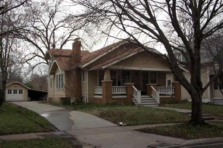
TABLE OF CONTENTS
Introduction .................................................................................................................................................1

Methodology ...............................................................................................................................................4

Historical Overview of Barker Neighborhood, Lawrence ..........................................................................5

Architectural Analysis................................................................................................................................24

  QUEEN ANNE ...........................................................................................................................................25
  ITALIANATE ..............................................................................................................................................26
  NATIONAL FOLK .......................................................................................................................................28
  FOLK VICTORIAN ......................................................................................................................................29
  COLONIAL REVIVAL ..................................................................................................................................30
  DUTCH COLONIAL REVIVAL......................................................................................................................32
  MISSION ...................................................................................................................................................33
  TUDOR REVIVAL .......................................................................................................................................35
  GOTHIC REVIVAL ......................................................................................................................................36
  CRAFTSMAN BUNGALOW ........................................................................................................................37
  PRAIRIE.....................................................................................................................................................40
  MINIMAL TRADITIONAL ...........................................................................................................................41
  RANCH......................................................................................................................................................43
  SPLIT LEVEL ..............................................................................................................................................44
  MODERN MOVEMENT .............................................................................................................................46
  POST MODERN.........................................................................................................................................48
  VERNACULAR ...........................................................................................................................................49
Survey Results and Recommendations ....................................................................................................51

Bibliography ...............................................................................................................................................57

APPENDIX A: TABLE OF SURVEYED PROPERTIES ......................................................................................61

                                                                                                                                                              i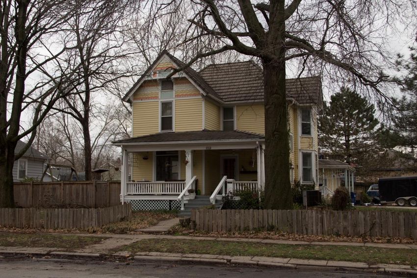
FIGURES AND TABLES
FIGURE 1. LOCATION MAP. VICINITY OF THE BARKER NEIGHBORHOOD ...................................................................... 2
FIGURE 2. BARKER NEIGHBORHOOD IS IDENTIFIED BY THE BOXED AREAS ON THE MAP. ............................................ 3
FIGURE 3. BARKER NEIGHBORHOOD IS IN SOUTH LAWRENCE...................................................................................... 6
FIGURE 4. SANBORN MAP, LAWRENCE, 1905 ................................................................................................................ 7
TH
FIGURE 5. PHASE I SURVEY AREA SUBDIVISIONS NORTH OF E. 19 STREET. ................................................................ 9
TH
FIGURE 6. PHASE I SURVEY AREA SUBDIVISIONS SOUTH OF E. 19 STREET. .............................................................. 10
FIGURE 7. 1901 NEW HAMPSHIRE STREET IS DEPICTED ON THE CITY’S 1905 SANBORN MAP ................................... 11
FIGURE 8. CALIFORNIA STYLE AIRPLANE BUNGALOW.. ............................................................................................... 17
FIGURE 9. 2005 NEW HAMPSHIRE STREET, AIRPLANE BUNGALOW ............................................................................ 18
FIGURE 10. 2245 NEW HAMPSHIRE STREET WAS LIKELY DESIGNED BY OWNER JOHN F. STUBECK ........................... 19
FIGURE 11. 2146 RHODE ISLAND STREET IS A CONCRETE BLOCK DWELLING .............................................................. 20
FIGURE 12. 1919 RHODE ISLAND STREET AND 2041 BARKER AVENUE. ...................................................................... 21
FIGURE 13. 1617 NEW HAMPSHIRE STREET, QUEEN ANNE STYLE .............................................................................. 26
FIGURE 14. 2045 NEW HAMPSHIRE STREET IS AN ITALIANATE STYLE DWELLING ....................................................... 28
FIGURE 15. THE NATIONAL FOLK MOVEMENT IS REPRESENTED BY 1929 NEW HAMPSHIRE ..................................... 29
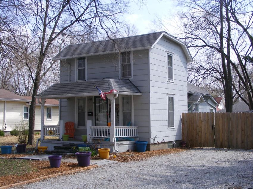
FIGURE 16. 1746 NEW HAMPSHIRE STREET IS A FOLK VICTORIAN STYLE DWELLING. ................................................ 30
FIGURE 17. 1501 RHODE ISLAND STREET IS AN EXAMPLE OF A COLONIAL REVIVAL STYLE DWELLING ...................... 32
FIGURE 18. 2210 NEW HAMPSHIRE STREET IS A DUTCH COLONIAL REVIVAL STYLE DWELLING ................................. 33
FIGURE 19. THE DWELLING AT 2115 NEW HAMPSHIRE ILLUSTRATES RESTRAINED MISSION STYLE DETAILING. ....... 34
FIGURE 20. 117 E. 17TH STREET AND 2245 NEW HAMPSHIRE STREET ARE TUDOR REVIVAL STYLE DWELLINGS ....... 36
FIGURE 21. 1601 NEW HAMPSHIRE STREET IS AN EXAMPLE OF GOTHIC REVIVAL STYLE ARCHITECTURE.................. 37
FIGURE 22. THE PHASE I SURVEY IS DOMINATED BY THE CRAFTSMAN BUNGALOW STYLE ....................................... 39
FIGURE 23. 1517 NEW HAMPSHIRE STREET, CONSTRUCTED IN 1910, IS A PRAIRIE STYLE DWELLING ...................... 41
FIGURE 24. 1500 RHODE ISLAND STREET IS AN EXAMPLE OF A MINIMAL TRADITIONAL STYLE DWELLING. .............. 42
FIGURE 25. 1743 BARKER AVENUE IS A RANCH STYLE DWELLING. ............................................................................. 44
FIGURE 26. CONSTRUCTED IN 1950, 2212 RHODE ISLAND STREET IS A SPLIT-LEVEL PLAN DWELLING ..................... 46
RD
FIGURE 27. 306 E. 23 STREET IS A SINGLE-FAMILY DWELLING CONVERTED TO A DENTAL OFFICE .......................... 47
FIGURE 28. THIS POST-MODERN STYLE DWELLING AT 1747 BARKER AVENUE WAS CONSTRUCTED IN 1987 ............ 49
TH
FIGURE 29. THE DWELLING AT 115 E. 17 TERRACE, CONSTRUCTED IN 1925, IS IDENTIFIED AS VERNACULAR ........ 50
TH
FIGURE 30. SURVEY AREA’S CONSTRUCTION DATES, BY DECADE, NORTH OF E. 19 STREET .................................... 52
TH
FIGURE 31. SURVEY AREA’S CONSTRUCTION DATES, BY DECADE, SOUTH OF E. 19 STREET .................................... 53
FIGURE 32. THE DWELLING AT 2000 NEW HAMPSHIRE STREET MAY BE INDIVIDUALLY ELIGIBLE .............................. 55
FIGURE 33. THE DWELLING AT 2207 NEW HAMPSHIRE STREET MAY BE INDIVIDUALLY ELIGIBLE .............................. 55
TABLE 1. PLATTED SUBDIVISIONS (PRE-2000) IN BARKER NEIGHBORHOOD .................................................8
TABLE 2. POPULATION OF LAWRENCE, KANSAS, 1860 – 1980 ....................................................................13
TABLE 3. DWELLINGS UNDER CONSTRUCTION, 1921-1922.........................................................................15
TABLE 4. SURVEYED PROPERTIES – PERIOD OF CONSTRUCTION (BY DECADE) ...........................................15
TABLE 5. ARCHITECTURAL STYLES/FORMS ..................................................................................................24
TABLE 6. SURVEYED BUILDINGS BY DECADE ................................................................................................51
ii
Introduction

In 2019, the City of Lawrence issued a Request for Proposal to conduct a Phase I Intensive
Survey of the Barker neighborhood (Lawrence, Douglas County, Kansas) (Figure 1). Barker
neighborhood is situated immediately south of the East Lawrence neighborhood and east of the
University of Kansas. The survey area, which comprises the western edge of the Barker
neighborhood, is bounded on the north by E. 15th Street, on the east by Barker Avenue, on the
south by E. 23rd Street and on the west by properties along the west side of New Hampshire
Street. The Barker neighborhood as a whole extends several blocks further east, bounded by
Burroughs Creek Rail Trail east of Delaware Street (Figure 2).

The survey identified 326 properties. Seven (7) properties appear to date to the late nineteenth-
century, all but one dwelling (2127 Barker Avenue) are on New Hampshire Street (1617, 1637,
1700, 1746, 1900 and 2045). All but six (6) of the properties are single-family dwellings. One
property constructed as a dwelling, 306 E. 23rd Street, has been remodeled and is currently a
dental office (106 E. 23rd Street). Two properties are multi-family dwellings: 1931-1933 Rhode
Island Street and 1725 New Hampshire Street. The survey also identified two churches at 1501
and 1601 New Hampshire Street. There are no industrial buildings in the survey area. One
inventoried property is a vacant lot that was never developed, 2021 New Hampshire Street.
Appendix A provides a complete list of the inventoried buildings, architectural styles and
proposed eligibility determinations.

The survey project was funded by a Historic Preservation Fund (HPF) grant received by the City
of Lawrence from the Kansas State Historical Society/Historic Preservation Office (KS-SHPO)
and the National Park Service. The project was awarded to and completed by Keenoy
Preservation (Adam Flock, Terri Foley and Ruth Keenoy) of St. Louis, Missouri. The purpose of
the survey was to document properties in the Barker neighborhood that appear potentially eligible
for the National Register of Historic Places and to determine whether the neighborhood may
support a historic district.

The following document provides an historical overview and contextual discussion about the
neighborhood’s development and growth, as well as an architectural analysis of properties within
the survey area. This document further provides recommendations for future preservation
activities in the Barker neighborhood.

                                                                                               1
Figure 1. Location Map. Vicinity of the Barker Neighborhood / Phase I survey area is indicated by the red
star. City of Lawrence, Kansas. Source: Google Maps, 2019.

                                                                                                            2
Figure 2. Barker Neighborhood is identified by the boxed areas on the map. The area to the left,
outlined in red, includes the Phase I survey area. The area in blue, to the right, is the remaining
Barker neighborhood not yet surveyed (Source: City of Lawrence, interactive map).

                                                                                                      3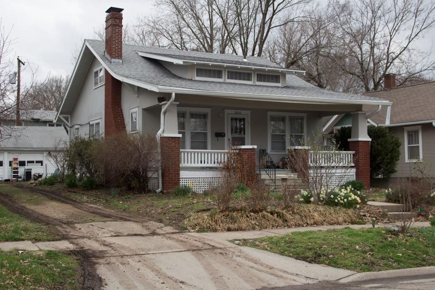
METHODOLOGY
The Barker Neighborhood Intensive Survey (Phase I) was initiated in April 2019. On April 5,
2019, Ruth Keenoy and Adam Flock met with staff from the Kansas State Historic Preservation
Office (KS-SHPO) and City of Lawrence in Topeka to discuss the survey expectations.
Photography of the Barker neighborhood survey area was completed by Mr. Flock and Ms.
Keenoy on April 4-5, 2019. Research was conducted by Ms. Keenoy at the Kansas State
Historical Society (Topeka), Lawrence Public Library and University of Kansas. The initial
public meeting was held at City Hall in Lawrence on April 6, 2019.

Fieldwork consisted of digital photography of all properties (including outbuildings) within the
survey area. Digital photos were uploaded to the Kansas Historic Resources Inventory (KHRI)
online database. Survey forms (also on the KHRI database) were completed for each inventoried
property (Foley and Keenoy) as were individual site maps (Flock and Keenoy). Photographs were
uploaded to KHRI and saved in TIFF format per the survey requirements.

Following the field inventory and research phases of the project, an historical overview was
developed to support the assessment of potentially eligible properties (individually and as a
district) within the survey area. Information utilized to complete the survey report was compiled
utilizing information gathered during the research process, including (but not limited to)
Lawrence city directories, maps, city plans, previous survey data and National Register
nominations. The survey report was completed by Ruth Keenoy and Terri Foley.

Additional resources utilized to gather information and produce this document include
guidelines/bulletins issued by the National Park Service, thematic studies and general research
regarding early twentieth-century residential neighborhoods. Online sources and digital historical
records (including those provided by City of Lawrence, Kansas Historical Society and the
University of Kansas) were utilized to assist in developing the historical contexts.

Activities throughout the project were coordinated with the KS-SHPO and City of Lawrence to
ensure that all available resources/repositories were utilized to support the findings and
recommendations of the survey project. The Phase I Intensive Survey was completed per
guidelines provided by the City of Lawrence, KS-SHPO’s “Historic Preservation Fund (HPF)
Products Manual,” and National Register Bulletin 24: Guidelines for Local Survey: A Basis for
Preservation Planning.

                                                                                                4
HISTORICAL OVERVIEW OF BARKER NEIGHBORHOOD, LAWRENCE
Lawrence’s Barker neighborhood is situated south of downtown Lawrence. The area supports the
city’s older commercial and business sectors, as well as the University of Kansas.1 The Barker
neighborhood did not begin to develop in earnest until the early twentieth century, although five
dwellings in the Phase I survey area appear to date to the late nineteenth century. The
neighborhood is bounded by E. 15th Street (north), Burroughs Creek Rail Trail (east), E. 23rd
Street (south) and Massachusetts Street (west). The Barker neighborhood is situated immediately
south of the East Lawrence neighborhood and north of Haskell Indian Nations University
(Figure 3), both of which were well established by the time Barker neighborhood became
developed. East Lawrence’s residences were constructed primarily during the nineteenth- and
early twentieth-century. Like Barker, the neighborhood is bounded on the east by Massachusetts
Street, which supported the city’s primary commercial corridor and streetcars by the 1870s. This
latter improvement assisted in developing South Lawrence and extending the city’s limits south.2
Haskell Indian Nations University was established well beyond the city’s limits in 1884 as an
“off-reservation” boarding school for Native American students. Both East Lawrence and Haskell
Indian Nations University feature National Register listed properties (listed in 1966 [Haskell],
2004 - 2007 [East Lawrence]). Haskell Indian Nations University is also a National Historic
Landmark (1961).3 Barker neighborhood, in contrast to the areas flanking it on the north and
south, did not begin to develop until the 1910s, though a few dwellings did exist in the
neighborhood prior to that time.4

The Barker neighborhood supports a number of subdivision plats (Table 1). Figures 5 and 6
illustrate the subdivisions within the Phase I survey area. Three of these subdivisions were platted
in the nineteenth century: Babcock’s Enlarged Addition (1865), Cranson’s Subdivision (1870)
and Haskell Place (1887).5 Sanborn maps published in the nineteenth century fail to illustrate
anything south of Adams Street (currently E. 14th Street). By 1905, however, the city’s limits had
been extended south to E. 21strd Street, encompassing most of the Phase I Barker survey area
(Figure 4). One dwelling in the neighborhood, 1901 New Hampshire Street, is depicted on the
City’s 1905 Sanborn map within the Haskell Place Addition (Figure 7). By 1912, Sanborn maps
illustrate that the city’s limits had been south to present day E. 21st Street, two blocks north of the
neighborhood’s southern boundary. By that time, it is also notable that north of E. 19th Street,
Connecticut Street had been renamed as Barker Avenue, also the name of the residential area
under development south of E. 15th Street. 6 Both the neighborhood and street (Barker) were

1
  Federal Writers’ Project of the Works Projects Administration, The WPA Guide to 1930s Kansas (Lawrence:
University Press of Kansas, 1939; reprint 1984), 220.
2
  Cathy Ambler and Elizabeth Rosin, “South Rhode Island and New Hampshire Streets Historic Residential
District,” National Register of Historic Places Nomination Form (2004), 8:2, 8:24.
3
  Stephen Lisandrello, Cecil McKitchen and Sarah J. Pearce, “Haskell Institute,” National Register of Historic
Places – Registration Form (1987), NR-8:1.
4
  Ibid, E:11. 18.
5
  City of Lawrence, Kansas, Interactive Map, Available at: https://lawrenceks.org/maps/#interactive (Access date: 20
May 2019).
6
  Sanborn Fire Insurance Map, Lawrence, Kansas (1905 Cover and Sheet 17; 1912 Cover), Digital Collection –
Kenneth Spencer Research Library, University of Kansas. Available at: https://luna.ku.edu/luna/servlet (Access date:
26 June 2019).

                                                                                                                  5
named for George J. Barker (1842-1912), who moved to Lawrence in 1867 and served as Kansas
State Senator (1884), Lawrence’s mayor (two non-consecutive terms in 1887 and 1907) and
“lower house member” (three terms in 1897, 1901 and 1903).7

Figure 3. Barker Neighborhood is in South Lawrence between the city’s East Lawrence Neighborhood (north)
and Haskell Indian Nations University (south) (Source: City of Lawrence Interactive Map. Available at:
https://lawrenceks.org/maps/#interactive).

7
 William E. Connelley, A Standard History of Kansas and Kansans (Chicago: Lewis Publishing Company, 1918),
Volume 5: 2362-2363.
                                                                                                             6
Figure 4. Sanborn Map, Lawrence, 1905 (not to scale). Barker Neighborhood surrounded by red line. Survey
area is left of the blue line. Note city limits – dotted line two blocks north of Merchant Mills Road (currently
E. 21st Street).

                                                                                                                   7
Table 1. Platted Subdivisions (pre-2000) in Barker Neighborhood
Name of Subdivision* Year Platted
Babcock’s Enlarged Addition* 1865
Barker Place 1952
Barker Place No. 2 1953
Barker Place No. 2 Re-plat 1979
Brookdale Addition No. 2 1955
Brookdale Addition No. 3 1955
Brookdale Addition No. 4 1969
Brookdale Addition Re-plat 1960
Brookdale’s Addition 1954
Cranson’s Subdivision* 1870
Evergreen Addition 1938
Evergreen Addition No. 2 1978
Friend’s Place 1966
Haskell Place* 1887
Haskell Place No. 2* 1978
Hosford’s Addition* 1909
Hosford’s Second Addition* 1908
India Addition 1958
Industrial Square One Nine No. 2 1988
Industrial Square One Nine Re-plat 1980
Leanard Court 1969
Lindley Addition* 1911
Maple Lawn 1909
Pence Addition 1971
Sehon’s Addition 1953 1953
Smith’s, B.F. Subdivision* 1908
Smith’s, George S. Addition* 1963
Spalding Subdivision 1926
Turney Addition 1959
*Located within Phase I survey area.
8Figure 5. Phase I survey area subdivisions north of E. 19th Street (Source: Interactive map, City of Lawrence.
Available at: https://lawrenceks.org/maps/#interactive).
9Figure 6. Phase I survey area subdivisions south of E. 19th Street (Source: Interactive map, City of Lawrence.
Available at: https://lawrenceks.org/maps/#interactive).
10Figure 7. 1901 New Hampshire Street is depicted on the City’s 1905 Sanborn map (upper) and in the above
photo (2019, Keenoy).
11The neighborhood’s large number of small subdivisions imitates a pattern of residential
development typically seen prior to 1900. Lawrence, however, did not develop as quickly as other
cities of its current size. As a result, residential areas within the city’s limits were enlarged
incrementally, supporting small additions as needed for new development.8 This pattern continued
well into the twentieth century because Lawrence’s population failed to grow significantly until
the 1940s.9 This pattern appears typical for other South Lawrence residential neighborhoods.10
One example is Breezedale, platted in 1909 by Charles E. Sutton. This was approximately the
same time that Barker’s development also began. Breezedale is a small subdivision, currently a
historic district (NRL 2007), situated southwest of the Barker neighborhood. Breezedale is
bounded on the north by E. 23rd Street – the same thoroughfare that defines Barker’s southern
boundary. Both areas are adjacent to Massachusetts Street, which as noted supported the city’s
early streetcars. Mr. Sutton platted the subdivision to capitalize on the city’s announcement that
the streetcar line would be extended south (along Massachusetts Street) to E. 23rd Street.
Breezedale, however, developed similarly to the Barker survey area – while a number of
dwellings were constructed in the early 1900s, the neighborhood also supports housing from the
1940s-1960s.11 The streetcar did prompt developers and builders to plat and construct housing in
the Barker neighborhood as well, supported by the fact that the survey area’s oldest dwellings are
within its older additions near Massachusetts Street (which supported streetcars).
Lawrence, as noted, grew slower than other regional cities. The city was described in the 1930s, a
community “less affected by synthetic booms than many Kansas cities.” 12 During the nineteenth-
century, the city’s population growth was deterred by the Civil War, Panic of 1873 and inability
to attract major industrial investment.13 Even so, the city did manage to grow steadily (Table 2).
It is notable that Lawrence never experienced a decade of recorded population loss. This is
unusual as most cities experienced declines during at least one decade. The University of Kansas,
established in 1865 is likely a major reason why this did not occur in Lawrence. By the early
twentieth-century, neighborhoods near the university (such as Barker) were under development
and growing much faster than areas north of the Kansas River. This prompted a number of new
subdivisions, extension of the streetcar line and new roads (once automobiles came into fashion)
to provide direct access to the university and growing southern residential sectors.14
8
David L. Ames and Linda Flint McClelland, National Register Bulletin: Historic Residential Suburbs (Washington,
D.C.: National Park Service, 2002), 26.
9
Dale E. Nimz, “Historic Resources of Lawrence, Douglas County, Kansas: Lawrence Modern, 1945-1975,”
National Register of Historic Places Multiple Property Documentation Form (2013), E:7.
10
David Dary, Pictorial History of Lawrence (Lawrence: Allen Books, 1992), 321-322.
11
Dale E. Nimz, “Breezedale Historic District,” National Register of Historic Places Registration Form (2005, NRL
2007), 8:9-10.
12
Federal Writers’ Project of the Works Projects Administration, 222; Dary, 362.
13
Deon Wolfenbarger, “Historic Resources of Lawrence, Douglas County, Kansas” (National Register of Historic
Places Multiple Documentation Form, 2001), E:10, 15, 24.
14
Ibid, E:23.
12Table 2. Population of Lawrence, Kansas, 1860 – 1980*
Year Population
1860 1,645
1870 8,320
1880 8,510
1890 9,997
1900 10,862
1910 12,374
1920 12,456
1930 13,726
1940 14,390
1950 22,351
1960 32,858
1970 45,698
1980 52,738
*Source: United States Census. Available at: https://www.census.gov/programs-surveys/decennial-
census/decade.1920.html.
The Phase I survey area’s most active construction period was the 1920s, which coincides with a
substantial increase in Lawrence’s population, rising from 12,456 in 1920 to 13,726 in 1930. The
surge was prompted by increased enrollment at the University of Kansas. By the early 1920s,
students were increasingly coming to Lawrence from other cities and states. This was a problem
for the university, which had no on-campus housing until 1923.15 The problem was foreseen but
not addressed for nearly two decades. In 1908, a university publication noted that female students
faced challenges in finding safe and suitable housing. Off-campus solutions frequently met
“opposition from boardinghouse owners, parents and others overly concerned about the special
issues that women faced in terms of the moral and social order.” 16 With no options, many
residential areas near the university, such as Oread, were converted to student housing, prompting
the development of areas further south (such as Barker) as single-family neighborhoods.17
15
Ibid, E:19; University of Kansas, “Seeds of Construction,” Available at: https://kuhistory.ku.edu/articles/seeds-
construction Access date: 1 July 2019).
16
University of Kansas, “Seeds of Construction.”
17
University of Kansas, “Rooms with a View,” Available at: https://kuhistory.ku.edu/articles/rooms-view (Access
date: 1 July 2019).
13The 1920s building boom in Lawrence was bolstered by falling costs in relation to building
materials. Although the United States participated in World War I briefly (1917-1918) and did
not encounter supply shortages as massive as those during World War II, the First World War did
impact the building industry by imposing higher costs for private construction. 18 These two
factors – university housing shortages and cheaper building materials after World War I – appear
to have significantly impacted residential construction in the Barker neighborhood during the
1920s (Table 3).19 As noted in a local newspaper in 1921 . . .
After a long period of several years during which construction was limited almost
entirely to business projects, home building is under way again. A dozen or more
houses are now being built. Many others have just been completed and many
more are about to start. Probably $100,000 is represented in the work under
construction at the present time. The houses run in size from small cottages to
large dwelling houses.20
18
Robert Higgs, “Construction Boom and Bust Between the World Wars,” Foundation for Economic Education (1
June 2008, Available at: https://fee.org/articles/construction-boom-and-bust-between-the-world-wars/), Access date:
2 July 2019.
19
“Home Building in Full Swing Here,” Lawrence Daily Journal-World (5 June 1922), 1.
20
“Much Building is Done This Summer,” Lawrence Daily Journal-World (4 April 1921), 1.
14Table 3. Dwellings under construction (noted in newspapers), Barker neighborhood, 1921-1922*
Address / Location Owner Year Built
1630 Barker Avenue* Johnson, F. Ellils 1921
1706 Barker Avenue* Allen, L.C. 1921
1801 Barker Avenue Cantrell, H.H. 1921-22
1846 New Hampshire Street Constant, C.H. 1921
1901 Barker Avenue Hunzicker, John 1921-22
1925 New Hampshire Street Hunsinger, Otto 1922
2003 Rhode Island Street Wickersham, F.H. 1922
2015 New Hampshire Street Pettibone, C.B. 1922
2025 New Hampshire Street Henderson, Charles L. 1922
2131 New Hampshire Street** Wood, Charles 1922
2219 New Hampshire Street Stutz, John G. 1921
Sources: Lawrence Daily Journal-World (4 August 1921, 2 January 1922, 5 June 1922); Lawrence City Directories.
[*East of Phase I survey area;**No such address-probably 2121 New Hampshire or 2131 Rhode Island].
.
Table 4. Surveyed Properties – Period of Construction (By Decade)
Decade Total Buildings in Survey Area
Pre-1900 7
1900 - 1909 27
1910 – 1919 54
1920 – 1929 112
1930 – 1939 19
1940 – 1949 45
1950 – 1959 39
1960 – 1969 7
1970 – 2016 15
The Barker neighborhood clearly illustrates Lawrence’s residential building boom of the 1920s.
Most buildings within the Phase I survey area date to this decade (Table 4) during which time
15112 (34%) of the buildings surveyed were constructed. Housing styles of the era include
Craftsman/Bungalow, Colonial Revival and Dutch Colonial Revival primarily, as discussed in the
Architectural Analysis section of this document. While not documented, there is a strong
likelihood that some dwellings within the neighborhood may be catalog housing. Mail-order
housing plans were tremendously popular in the United States by the early twentieth-century,
focusing on the styles noted above. Prior to the Great Depression, companies such as Sears,
Aladdin and Montgomery Ward also sold prefabricated kit housing. Some companies that sold
plans (but not prefabricated kit homes) managed to survive the Great Depression and did well
after World War II. One of the most successful was the L.F. Garlinghouse Company of Topeka. 21
Due to the location and commercial success of this company in particular, there is a high
probability that Barker neighborhood has examples of catalog plan dwellings.
One property type in particular – documented in the Phase I survey and frequently associated with
the Garlinghouse Company – is the Airplane Bungalow. These dwellings are small Bungalows
that feature a pop-up second story. The subtype was originally associated with the California
Bungalow, featuring a central second-story pop-up floor plan (Figure 8). 22 Examples in the
Barker neighborhood, however, feature rear– rather than central – second-story pop-ups (Figure
9). This type of Airplane Bungalow also reflects the style promoted by the Garlinghouse
Company. While some researchers identify the rear pop-up Airplane Bungalow as “a Topeka
original” due to that city’s many examples, it is unknown exactly when or who introduced this
uniquely designed property type.23 A Multiple Property Documentation Form completed for the
City of Emporia (Lyon County), Kansas identifies this type of Airplane Bungalow as a “camel-
back or an airplane tail bungalow.”24 Thirteen Airplane Bungalows were documented in the Phase
I survey area. Based on information provided by one property owner, all of the Airplane
Bungalows in the 2000 Block of New Hampshire Street were all constructed by a single builder.
21
Daniel D. Reiff, Ideal Homes of the Thirties (Mineola, New York: Dover Publications Inc., 2010), iii; Max D.
Movsovitz (ed), Bungalow Homes for the Nation: The L.F. Garlinghouse Co. of Topeka (Topeka: Shawnee County
Historical Society, 2008), 8.
22
Antique Home Style (Summer 2018), Available at: https://www.antiquehomestyle.com/plans/stillwell/18
stillwell/r819.htm (Access date: 2 July 2019).
23
Movsovitz, 46.
24
Kelly Merrifield, Justin Krockitz and Kim Gant, “Craftsman-style Dwellings of Emporia, Lyon County, Kansas,
1900-1930,” National Register of Historic Places Multiple Property Documentation Form (2014), F:17.
16Figure 8. California Style Airplane Bungalow. Note the central pop-up wing (designed by E.W. Stillwell, c.
1918). Image available at: https://www.antiquehomestyle.com/plans/stillwell/18stillwell/r819.htm.
17Figure 9. 2005 New Hampshire Street is the type of Airplane Bungalow most typically seen in Kansas. Note
the rear pop-up wing. (Photo: Keenoy 2019).
During the 1930s, there was a vast drop in construction projects in the Phase I survey area. Only
19 surveyed properties appear to date to the 1930s. One of the most notable is a Tudor Revival
style dwelling at 2245 New Hampshire Street constructed in 1935. The dwelling is believed to
have been designed by its original owner, John F. Stubeck (Figure 10). Based on census records,
John F. Stubeck was born in 1886 and died in 1960, the son of Swedish immigrants. In 1920,
Stubeck was living in Lawrence and working as a teacher. In 1930 he was employed as a building
inspector and in 1940, listed as a self-employed architect/builder. Stubeck was married to Millie
Field Carter and the couple had one son, John F. (Fred) Stubeck, Jr.25 There is a likelihood that
Stubeck designed other properties in the neighborhood though to date, this has not been
documented.
25
John F. Stubeck, Census and Burial Records available at Ancestry.com (Access date: 27 June 2019).
18Figure 10. 2245 New Hampshire Street was constructed in 1935 and likely designed by owner John F. Stubeck
(Photo: Keenoy, 2019).
Few builders or architects have been identified in association with the Barker neighborhood. One
reason for this is that city directories do not provide information about residents’ occupations. The
only other individual currently identified by name, associated with development of the
neighborhood, is C.B. Hosford, who platted two of the neighborhood’s additions in 1908 and
1909. Hosford was a real estate developer who emerged as a major investor/mortgage company
owner during the 1910s. Although it is not known if he directly had anything to do with the
houses constructed in Barker neighborhood, he was responsible for platting two of the
neighborhood’s early subdivisions.26
Of note in the survey area are the neighborhood’s concrete houses. Seven examples were
documented – three constructed in the 1920s (109 19th Street, 1919 Rhode Island Street and 2041
Barker Avenue) and four in the 1940s (1916 New Hampshire Street, 2010 Rhode Island Street,
2145 Barker Avenue and 2146 Rhode Island Street). While concrete was primarily used for
foundations in residential construction, it was also utilized to construct buildings, though
residential examples are less frequent. The survey area’s examples at 2145 Barker Avenue and
2146 Rhode Island Street (constructed in 1940 and 1946, respectively) are nearly identical, likely
constructed by the same builder (Figure 11). Both are located in the Haskell Place Addition.
Earlier examples at 1919 Rhode Island Street (constructed in 1922) and 2141 Barker Avenue
(constructed in 1920) are constructed of patterned concrete blocks mimicking stone and brick
coursing (Figure 12). The prevalence of concrete construction in Lawrence has not been fully
26
Wolfenbarger, E:27.
19documented. Though concrete foundations created to look like stone are common, exterior
concrete patterned walls are not and may be architecturally significant.27
Figure 11. 2146 Rhode Island Street is a concrete block dwelling constructed in 1946 (Photo: Keenoy 2019).
27
Ibid, E:25.
20Figure 12. 1919 Rhode Island Street (top) and 2041 Barker Avenue were constructed in the early 1920s. These
dwellings have unique concrete exteriors (Photos: Keenoy and Flock, 2019).
21By the 1940s, construction in Barker neighborhood began to pick up pace. The decade’s initial
boom occurred in 1941 when Johnson County (immediately east of Douglas County) was selected
as the site of a federally funded propellant plant constructed to support World War II, the
Sunflower Ordinance Plant. Situated approximately 15 miles east of Lawrence, “speculators
began to plan for the construction crews” arriving to construct the munitions factory, as well as
the employees who followed them to Kansas.28
In August 1942, construction at Sunflower was well under way. By that time, the
construction crew numbered nearly twenty thousand men. Since there were no
plans for on-site housing, the surrounding area had to absorb this new population.
Most workers settled in Lawrence – from which five bus lines brought workers to
the plant at forty minute intervals.29
Following World War II, Lawrence’s rise in population continued as returning veterans enrolled
at the University of Kansas under the Serviceman’s Readjustment Act of 1944 (aka the G.I.
Bill). 30 This program raised university enrollment by 25% in 1945 and continued an upward
trajectory in the years that immediately followed. Campus buildings, including the stadium and
art museum basement, were converted to house students arriving in the 1940s while parents of
younger students “went door to door” in search of suitable off-campus housing. 31 Lawrence’s
population during the 1940s almost doubled, jumping from 14,390 in 1940 to 23,351 in 1950.32
The Barker neighborhood’s Phase I survey demonstrates the city’s 1940s housing construction
boom, documenting 45 properties constructed during the 1940s (more than double the number of
dwellings constructed in the 1930s). Popular styles of this period were dominated by Minimal
Traditional and Ranch influences. While the Barker neighborhood does not typify the suburban
explosion seen outside of the inner city during the 1940s-1950s, it does demonstrate how
influences such as returning veterans, postwar prosperity and financial incentives such as
Veterans Administration (VA) and Federal Housing Administration (FHA) loans impacted the
city’s undeveloped residential sectors.
By 1945, several factors – the lack of new housing, continued population growth,
and six million returning veterans eager to start families – combined to produce
the largest building boom in the Nation’s history, almost all of it concentrated in
the suburbs. From 1944 to 1946, single-family housing starts increased eight-fold
from 114,000 to 937,000. Spurred by the builders’ credits and liberalized terms
for VA- and FHA-approved mortgages by the end of the 1940s, home building
28
Thomas David Van Sant, “The Price of Victory: The Sunflower Ordinance Works and DeSoto and Eudora
Kansas,” Master’s Thesis (Kansas State University Department of History, 1989), 10.
29
Ibid, 13.
30
G.I. Bill of Rights,” Kansaspedia (Kansas Historical Society), Available at: https://www.kshs.org/kansapedia/g-i-
bill-of-rights/16707 (Access date: 27 June 2019).
31
University of Kansas, “Ladies of the Clubhouse,” Available at: https://kuhistory.ku.edu/articles/ladies-clubhouse
(Access date: 1 July 2019).
32
United States Census, Population and Housing, 1950 (Kansas, Douglas County, Lawrence), Volume I (Available
at: https://www.census.gov/prod/www/decennial.html) (Access date: 27 June 2019).
22proceeded on an unprecedented scale reaching a record high in 1950 with the
construction of 1,692,000 new single-family houses.33
During the 1950s, Lawrence experienced a continuation its postwar building boom. In the years
1950 – 1963, the city issued 2,740 building permits for residential construction alone. Most
activity was conducted in areas south and west of the Barker neighborhood but this trend also
directly affected the neighborhood.34 As noted in Table 4, 39 properties were identified in the
Phase I survey area as constructed in the 1950s. It is likely that outside of the Phase I survey area,
the neighborhood supports a larger number of dwellings constructed during the 1950s-1960s. This
assumption is based on the fact that the neighborhood’s oldest development area is within the
survey area and newer subdivisions (post 1949) are all east of the survey area. While residential
construction slowed in the Phase I survey area by 1960, this may not be true for the entire
neighborhood.
The 1950s – 1970s brought substantial changes to Lawrence. The city’s population again saw
significant increases and east of Lawrence, the Sunflower Ordinance plant was reactive to support
the Korean Conflict. New industry arriving in the 1950s – all situated east of downtown –
included sodium phosphate and nitrogen fertilizer plants and the Stokely canning factory. These
changes did much to promote the city, increase the population and attract commerce. Older inner-
city neighborhoods previously zoned to support single-family housing were rezoned for multi-
family properties and commercial development, discouraging “investment in the city core.”35 The
impacts that these decades had on the Barker neighborhood will remain uncertain until the entire
neighborhood is surveyed. The Phase I survey area supports only two multi-family properties,
both constructed after 1946 – a duplex and a small apartment building. No commercial buildings
were surveyed in the Phase I area, though one dwelling has been converted in recent decades to
house a dental office at the northeast intersection of Barker Avenue and E. 23rd Street.
In conclusion, Barker neighborhood had little development prior to 1900. Only seven (7)
dwellings in the survey area appear to predate 1900. After the turn of the century, the
neighborhood began to grow modestly as the streetcar line along Massachusetts Street was
extended south to the neighborhood’s southern boundary, E. 23rd Street. The city’s limits were
likewise expanded south to E. 23rd Street by 1912. The two decades that most impacted
development in the survey area were the 1920s and the 1940s, impacted by University of Kansas
enrollment, as well as economic prosperity and federal programs of the 1930s-1940s. Housing
styles in the survey area represent those popular elsewhere as discussed in the following section
of this document. Of note are regional and local building patterns, such as the aforementioned
Airplane Bungalows and concrete housing. Appendix A provides a complete list of the surveyed
properties, dates of construction, architectural styles and projected National Register eligibility
status upon completion the entire neighborhood survey.
33
Ames and McClelland, 65.
34
Dale E. Nimz, (2013), E:8.
35
Wolfenbarger, E:30-31.
23ARCHITECTURAL ANALYSIS
Barker neighborhood’s Phase I survey area is largely representative of popular housing styles of
the 1910s – 1950s. The residential neighborhood’s era of construction extends from 1871 – 2016.
All of the surveyed properties are single-family dwellings with exception of the following:
Two (2) religious buildings at 1501 and 1601 New Hampshire, both constructed ca. 1949.
One (1) commercial property at 306 E. 23rd constructed as a single-family dwelling ca.
1955 and converted to commercial use by 1961.
One undeveloped lot at 2021 New Hampshire Street.
Architectural styles within the Barker neighborhood include Colonial Revival (33 properties),
Craftsman Bungalow (109 properties), Dutch Colonial Revival (10 properties), Folk Victorian
(11 properties), Gothic Revival (1 property), Italianate (3 properties), Minimal Traditional (33
properties), Modern Movement (2 properties), National Folk (13 properties), Mission (1
property), Post Modern (1 property), Prairie (8 properties), Queen Anne (1 property), Ranch (54
properties), Split Level (5 properties) and Tudor Revival (12 properties). Other architectural
types found within the neighborhood include one vernacular dwelling, 18 dwellings classified as
having “no applied style” and nine (9) dwellings categorized as “other” (Table 5).
Twenty-seven (27) dwellings in the Barker neighborhood have not been assigned an architectural
style or property type. Typical of many neighborhoods in the United States, housing was often
constructed without reference to any specific style or builders incorporated minor details that fail
to exemplify a true architectural style or movement. These dwellings are outlined in the table
provided in Appendix A.
National Register eligibility recommendations based on the architectural characteristics
documented in the Phase I Barker neighborhood survey are reviewed in the following section of
this report entitled, “Survey Results and Recommendations.”
Table 5. Architectural styles/forms and number of examples in the Phase I Barker neighborhood survey.
Architectural New Rhode E. E. 17th E. E. E. E. E.
Style Total Barker Hamp. Island 17th Terrace 18th 19th 20th 21st 23rd
Craftsman/
Bungalow 109 16 55 27 0 1 5 5 0 0 0
Colonial
Revival 33 3 15 13 1 0 0 0 0 0 1
Dutch
Colonial
Revival 10 3 6 1 0 0 0 0 0 0 0
Folk Victorian 11 4 7 0 0 0 0 0 0 0 0
Gothic
Revival 1 0 1 0 0 0 0 0 0 0 0
Italianate 3 1 2 0 0 0 0 0 0 0 0
Minimal
Traditional 33 9 6 17 0 0 1 0 0 0 0
Mission 1 0 1 0 0 0 0 0 0 0 0
Modern
Movement 2 0 1 0 0 0 0 0 0 0 1
National Folk 13 1 8 4 0 0 0 0 0 0 0
24Architectural New Rhode E. E. 17th E. E. E. E. E.
Style Total Barker Hamp. Island 17th Terrace 18th 19th 20th 21st 23rd
No Style 18 4 5 4 1 3 0 0 1 0 0
Other 9 1 2 4 0 0 0 2 0 0 0
Post Modern
/New Eclectic 1 1 0 0 0 0 0 0 0 0 0
Prairie 8 1 6 1 0 0 0 0 0 0 0
Queen Anne 1 0 1 0 0 0 0 0 0 0 0
Ranch 54 14 5 28 0 3 3 0 0 1 0
Split Level 5 1 0 4 0 0 0 0 0 0 0
Tudor Revival 12 0 10 1 1 0 0 0 0 0 0
Vernacular 1 0 0 1 0 0 0 0 0 0 0
Total
Buildings*
Surveyed 325
*One inventoried property was a vacant lot and is not included in this table.
QUEEN ANNE (1 dwelling)
The Queen Anne style originated in England and embodies the peak of the romantic or
picturesque movement of the nineteenth century. Founded on the ideals of “decorative
overindulgence” and variation, the Queen Anne style was not an authentic representation of any
single style or historical architectural detailing, instead exhibiting a mixture of several stylistic
influences derived from the Victorian and Romantic eras.36
The style was created and promoted by Richard Norman Shaw and other English architects
during the late nineteenth century. The name was adapted to reflect the Renaissance style popular
during the reign of Queen Anne (1702-1714) but in actuality is more closely related to medieval
forms of the Elizabethan and Jacobean eras in England (which preceded the Renaissance style).
In the United States, the Queen Anne style became popular through the circulation of pattern
books and early architectural journals such as American Architect and Building News. The Queen
Anne style was prevalent in America, used primarily in residential architecture during the years
1880 to 1900. Technological advances in mass production of wood trim aided by railroad
transport helped to make building materials more affordable and accessible, which did much to
promote the style during the height of its popularity.37
Queen Anne style housing typically includes the following features:
Plan Shape: Irregular
Height: 1, 2 or 3 stories
Façade: Asymmetrical
Roof Type: Hipped with lower cross gables, cross gables, front gable; steeply pitched
36
Gerald Foster, American Houses, A Field Guide to the Architecture of the Home (New York: New York,
Houghton Mifflin Company, 2004), 278, 280.
37
Virginia McAlester and Lee McAlester, A Field Guide to American Houses (New York: Alfred A. Knopf, 1998),
268.
25Windows: Double-hung wood sash; bay windows, stained glass, asymmetrical
placement
Exterior: Brick or wood siding, patterned shingles or brickwork
Porches: Wraparound or full-width; commonly with decorative spindle work and
trim
Doors: Wood panel with glass; sidelight and transoms; door surrounds with
pediments, narrow columns or pilasters
Details: Dormers; towers, ornamentation in gable ends, stick work
Chimney: Tall
Figure 13. 1617 New Hampshire Street, constructed in 1887, is the sole documented example of the Queen
Anne style in the Phase I Barker neighborhood survey. The dwelling was renovated in 2008. The central and
north garage wings are not original (Photo: Flock, 2019).
ITALIANATE (3 dwellings)
The Italianate style was part of the Romantic, or Picturesque movement that emerged during the
mid-to-late nineteenth century. This movement sought architectural forms that hinted at earlier
periods of history. Prior to the Romantic Movement, architectural styles favored classical
adaptations. In contrast, the Romantic era articulated an aspiration for nonconformity of
architectural expression and harmonization with the natural setting.38
38
Ibid, 212, 214.
26The Italianate style was fashioned after medieval farmhouses found in the Italian countryside.
These dwellings embraced their rustic setting through their irregular form, a vital goal of the
romantic/picturesque movement. The Italianate style was promoted by Andrew Jackson
Downing, who in the 1840-1850s published architectural pattern books. The Italianate style
quickly became widespread and in the United States was notably popular in the period from 1855
through 1880.39
Italianate style housing typically includes the following features:
Plan Shape: Block form, square, multiple blocks combined, L-shaped, rectangular
Height: 2 or 3 stories
Façade: Symmetrical; sometimes asymmetrical
Roof Type: Hipped, hipped with centered gable; towered, cross hipped; towered
hipped
Windows: Double-hung wood sash; tall and narrow, arched and curved window tops;
paired or tripled paired
Exterior: Brick or wood siding
Porches: Small entry porches; sometimes full-with porches; one-story in height
with little detailing; square post with beveled corners
Doors: Wood panel with glass; paired and single; transoms; elaborate door
surrounds
Details: Window hoods, brackets found in cornice line, towers, cupolas
Chimney: Tall
39
Ibid.
27Figure 14. 2045 New Hampshire Street is an Italianate style dwelling in the Barker neighborhood. The
dwelling was constructed in 1873 (Photo: Keenoy, 2019).
NATIONAL FOLK (13 dwellings)
Prior to arrival of the railroad, transportation of mass-produced building materials was
problematic. Most goods were shipped via water, which was less reliable and slower than train.
Pre-railroad housing was typically unpretentious, constructed of locally available materials with
little or no stylistic embellishment. The progress of the railroad across the United States offered a
simple and inexpensive way to ship building materials. The railroad era ushered in an entirely
new era of housing construction in America, impacting both construction techniques and the
materials used for building. Houses were constructed with light balloon or braced framing
covered by wood siding. Such materials were more affordable than ever once the railroad arrived,
easily purchased through mail order catalogs. National style housing includes six standard house
forms: gable-front; gable-front-and-wing; hall-and-parlor; I-house; massed plan, side-gabled; and
pyramidal. Constructed of frame and often void of embellishment, National Folk housing was
prevalent in the United States during the mid-nineteenth through the early twentieth century.40
National Folk housing typically includes the following features:
Plan Shape: Rectangular; irregular; square
Height: 1, 2 or 2.5 stories
Façade: Symmetrical; sometimes asymmetrical
40
Ibid, 88-90.
28Roof Type: Side or front gable; cross gable; pyramidal
Windows: Double-hung wood sash; small panes; symmetrical placement
Exterior: Wood siding
Porches: Full-with porches; partial-width porches; one or full height; stoop
Doors: Wood panel with glass; transoms; usually not distinctive
Details: Very little ornamentation if any
Chimney: Brick; varies in height
Figure 15. The National Folk movement is represented by 1929 New Hampshire. The dwelling was
constructed in 1900 (Photo: Keenoy, 2019).
FOLK VICTORIAN (11 dwellings)
The Folk Victorian style evolved from the National Folk house movement and was popular
during the 1870s-1910s. Folk Victorian utilized simple house forms based on the earlier
residential buildings in the United States. Like National Folk housing, the arrival of the railroad
had much to do with the style’s popularity. Ready availability of lumber and pre-cut, inexpensive
Victorian detailing appealed to homeowners. Mass-produced embellishments were easily added
to older dwellings, as well as newly constructed homes. This allowed homeowners to update
older housing to reflect current architectural trends. The affordability and ease of constructing
Folk Victorian style dwellings were popular across the country as railroads gained access and
mass production became available.
Folk Victorian style housing typically includes the following features:
Plan Shape: Rectangular; irregular
29Height: 1, 2 or 2.5 stories
Façade: Symmetrical; sometimes asymmetrical
Roof Type: Side or front gable; hipped
Windows: Double-hung wood sash; small panes; symmetrical placement; sometimes
a pediment over the window
Exterior: Wood siding; sometimes brick
Porches: Full-with porches; wraparound porches; one-story in height; spindle work
detailing
Doors: Wood panel with glass; transoms; usually not distinctive
Details: Brackets under the eaves; spindle work
Chimney: Brick; average height
Figure 16. 1746 New Hampshire Street is a Folk Victorian style dwelling in the Barker neighborhood. The
house was constructed in 1871 (Photo: Flock, 2019).
COLONIAL REVIVAL (33 dwellings)
Colonial Revival dominated American residential architectural during the first half of the
twentieth century. The Colonial Revival style began to emerge as an architectural preference
following the 1876 Philadelphia Centennial Exhibition, which celebrated the founding of the
United States. 41 After the exhibition, a group of architects (William Bigelow, Charles Fallen
41
Mark Gelernter, A History of American Architecture: Buildings in Their Culture and Technological Context
(Hanover, NH: University Press of New England, 1999), 180.
30McKim, William Mead and Stanford While) amassed measured drawings and sketches of
Colonial-era dwellings while touring New England. Their effort launched a “new” architectural
design – Colonial Revival – “inspired by colonial precedents.”42 The acceptance and widespread
use of the style is also associated with architect Robert Peabody, a partner at Boston, Peabody
and Sterns. Peabody concluded the Queen Anne style shared many architectural characteristics
with the Colonial Revival style such as classical detailing, clustered chimneys and molded
brickwork. Peabody and others promoted Colonial Revival as a style reflective of a true
American past. This perception helped to perpetuate the style’s popularity.43 Colonial Revivalism
was echoed in the field of painting, sculpture, decorative arts and furniture. However, it was in
the field of architecture where Colonial Revivalism was most often expressed.44 The popularity
of the style in middle-class dwellings was spurred by balloon frame construction, as well as brick
and stone veneers –affordable construction methods that appealed to the middle class. As a result,
Colonial Revival endured decades of popularity (1880-1955) more so in residential architecture.45
Colonial Revival style housing typically includes the following features:
Plan Shape: Rectangular; sometimes irregular
Height: 1, 2 or 3 stories
Façade: Symmetrical; sometimes asymmetrical
Roof Type: Side gable; hipped
Windows: Double-hung wood sash; adjacent pairs; commonly offset by shutters;
Palladian window; symmetrical placement
Exterior: Brick or wood siding
Porches: Centered porch or stoop, full-width or may have wraparound; commonly
with classical columns; simple railings and balusters, when present
Doors: Wood panel with glass; sidelight and transoms; door surrounds with
pediments, narrow columns or pilasters
Details: Cornice decorated with dentils or modillions; dormers; porte-cochere;
boxed wall junctions with restrained overhanging eaves
Chimney: Tall and wide
42
McAlester and McAlester, 326.
43
Ibid, 36-38.
44
Richard Guy Wilson, The Colonial Revival House (New York: Abrams, 2004), 6.
45
Ibid, 185-186.
31Figure 17. 1501 Rhode Island Street is an example of a Colonial Revival style dwelling in the Barker
neighborhood. The dwelling was constructed in 1900 (Photo: Keenoy, 2019).
DUTCH COLONIAL REVIVAL (10 dwellings)
The Dutch Colonial Revival style is a subtype of the Colonial Revival style. It is a modification
of the original Dutch Colonial style established in the United States during the years 1650-1840.
The original movement is associated with the early inhabitants of present day New Jersey and
New York. The revival version of Dutch Colonial became very popular during the early 1900s -
1920s and declined during the 1930s.46 The Dutch Colonial style has a distinctive profile from
the Colonial Revival style due to its key feature, a gambrel roof. For this reason, such dwellings
are often referred to as “barn” houses. Dutch Colonial Revival was often published in popular
housing design catalogs of the 1910s-1920s, which helped to popularize the style.47
Dutch Colonial Revival style housing commonly includes the following features:
Plan Shape: Rectangular; sometimes irregular
Height: 2 to 2.5 stories
Façade: Symmetrical or asymmetrical
Roof Type: Gambrel roof; intersecting gables
Windows: Double-hung wood sash; adjacent pairs; often flanked by shutters
46
McAlester and McAlester, 322, 324.
47
“Colonial Revival: Dutch Colonial” Antique Home (Available at: http://www.antiquehome.org/Architectural-
Style/dutch-colonial.htm) Access date: 1 July 2019.
32You can also read