STRUCTURAL CARTOGRAPHIC ANALYSIS OF A THEMATIC ATLAS WORK: EXAMPLE OF THE CZECH HISTORICAL ATLAS - Style ...
←
→
Page content transcription
If your browser does not render page correctly, please read the page content below
Article no. 27

                                                              THE CIVIL ENGINEERING JOURNAL 1-2021

                           -------------------------------------------------------------------------------------------------

 STRUCTURAL CARTOGRAPHIC ANALYSIS OF A THEMATIC
ATLAS WORK: EXAMPLE OF THE CZECH HISTORICAL ATLAS

                           Tomáš Janata, Petra Jílková and Jan Daniel Bláha

  Czech Technical University in Prague, Faculty of Civil Engineering, Department of
       Geomatics, Thákurova 7, Praha 6, Czechia; tomas.janata@fsv.cvut.cz;
                   petra.jilkova@fsv.cvut.cz; jd@jackdaniel.cz

ABSTRACT
        The article introduces the Czech historiographical work called the Czech Historical Atlas and
presents its analysis in terms of its concept, structure and technical layout. The primary focus is on
the atlas content and its subdivision into thematic and logical sections or the semiological structure
of the used space. Last but not least, the cartographic and technical aspects of the atlas format are
also analysed, including, for example, the analysis of used scales or cartographic projections. The
findings are presented through a series of visuals and interpreted in the context of the thematic
concept of the atlas. The authors’ aim is to present the currently not much addressed structural
analysis of a cartographic atlas, which allows revealing the potential for the innovation of an original
cartographic work.

KEYWORDS
       Historiography, atlas cartography, Czech Historical Atlas, cartographic semiology

INTRODUCTION
        The Czech Historical Atlas (hereinafter also CHA, [1]) is one of the new works of Czech
historiography, aiming at least partially at presenting a complex overview of a selected segment of
the Czech history, both in terms of the time frame (20th century) or the spatial or material scope. The
atlas has come out after approximately five years of work as another achievement of a team of
historians, cultural geographers and cartographers. It builds on the cooperation among the team
members, who joined efforts in the preparation of the Academic Atlas of Czech History (hereinafter
also AACH, [2] – for more information cf. [3]), which, in many respects, can be considered as a
predecessor of CHA. Therefore, in this study, the Czech Historical Atlas will be, to some extent,
compared with AACH, particularly with its last chapter devoted to modern history.
        From the very beginning, the Czech Historical Atlas was conceived completely differently
than the Academic Atlas of Czech History. While cartographers had not been invited to the design
and the initial phase of the AACH preparation and development, and thus the map section of the
work was only created in a more advanced phase of work on the atlas, during the design of CHA,
the cartographic team had prepared a set of recommendations at the very start of work on the atlas,
and these recommendations were consulted with historians as the guarantors of the atlas content
part. Based on these recommendations, a set of technical designs, models and graphic styles was
created to be subsequently applied in the development of the atlas.
        At the start of work on the atlas, thematic sections were discussed and identified to be further
divided into chapters. Based on the graphic layout, this structure was fitted with individual text fields,
maps, images, reproductions and other content components. The aim was to achieve a higher level
of internal balance and consistency than was the case of AACH. From the very beginning, the
authors, i.e. historians and geographers, were acquainted with the limited space for the textual and

                                     DOI 10.14311/CEJ.2021.01.0027                                                 365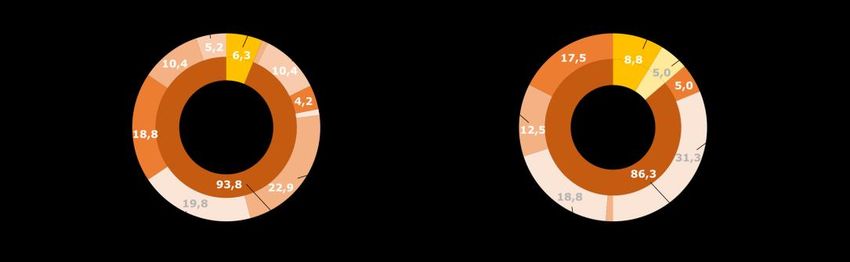
Article no. 27

                                                               THE CIVIL ENGINEERING JOURNAL 1-2021

                            -------------------------------------------------------------------------------------------------

pictorial part, and especially the part for thematic maps. Thanks to this step, the maps could be
prepared conceptually from the beginning eliminating thus the need for their repeated reworking and
modifications due to the limited space available.

OBJECTIVES
        The objective of the analysis presented in this article is to provide a basis for further
comparative analyses of atlas works, particularly those with a similar thematic focus. Another
authors’ objective is to reveal, on the one hand, undesirable disproportions in the methods of
presenting the topic, and, on the other hand, the unused potential for further innovations of the atlas,
which could find its application in future editions of the atlas.
        Unfortunately, structural analyses of cartographic atlases are not common at present,
although they can reveal valuable knowledge not only for the readers, but also for the authors of
these works themselves. Instead, numerous current analyses are more guided by the effort to assess
the quality (i.e. negative vs. positive aspects of the work) for the purposes of the peer-review process,
or for an easier choice between two similar products (with an exception of, e.g., a review in [4], which
evaluates the atlas as a whole in a relatively thorough way and goes into deeper comparisons).
Other analyses are more focused on the analysis of the mathematical fundamentals of maps,
addressing either the distortion of old maps or the cartographic projections available ([5]).
        Such analyses, however, usually lack sufficient in-depth exposure to identify further
possibilities for the innovation of the cartographic work (for future publications of the work, for further
cooperation of cartographers with experts in the thematic content, etc.). It is structural analysis that
can help to reveal, among other things, the relationship between the thematic focus of maps in the
atlas and the degree of its complexity, as well as the depth of the concept of the work (appropriate
diversity of scales, used methods of thematic cartography, etc.). The results of such an analysis in
particular lead the authors to questions like: Has the potential of cartographic representation of the
thematic content been used effectively? Was the effort of the experts specializing in the thematic
content of maps to include in it as many known objects and phenomena as possible adequate or
over the top?
        A relatively crucial step is also the visualization of the results of the analysis allowing a simple
synthesis with a subsequent comparison. In addition to commonly used visualization concepts of
similar data (e.g. [6]), the authors built on their previous experience in this type of analysis.

Atlas Concept
       Unlike AACH, whose topics offer an overview of periods from prehistory to the beginning of
      st
the 21 century, CHA is exclusively devoted to selected 20th-century chapters considered as periods
of great social changes (not only) in Central Europe. Thus, it extensively develops the topics treated
in AACH only in the last chapter dedicated to modern history, or introduces completely new topics.
With a view to the chronological and thematic continuity of both atlases works, individual parts of the
analysis will compare the CHA content and structure mainly with the AACH last Chapter V. The
comparison with AACH as a whole does not seem to be very useful due to the different scope, focus
and concept of both works (see Table 1).
       In contrast to most historiographical works, which typically respect the chronological
subdivision of the thematic content, CHA applies a relatively non-traditional form of a thematic
subdivision placing the content of depicted topics in factual and social contexts.

                                      DOI 10.14311/CEJ.2021.01.0027                                                 366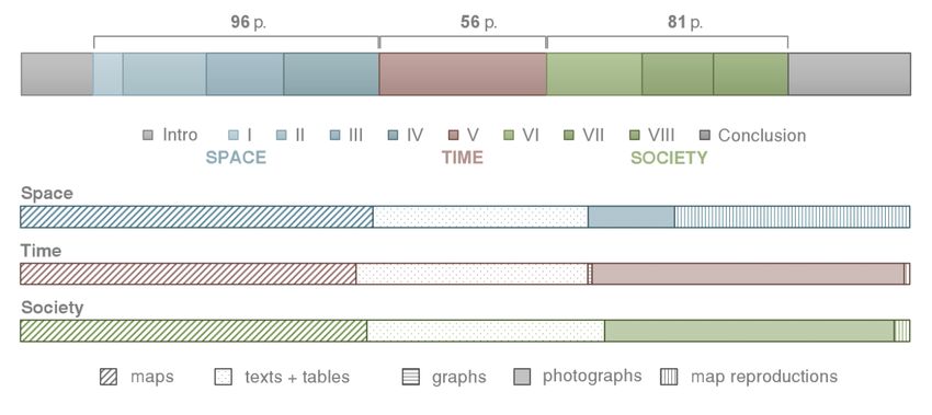
Article no. 27

                                                                THE CIVIL ENGINEERING JOURNAL 1-2021

                             -------------------------------------------------------------------------------------------------

                 Tab. 1 Comparison of CHA and AACH by scope. Source: authors.

                                            CHA                       AACH                   AACH
                                                                                           (Chap. V)

                  number of                  297                        587                     89
                    pages

                  number of                   96                        365                     73
                    maps

                 dimensions        234 × 326 × 28 mm          308 × 427 × 60 mm                 ––

                    weight                  970 g                     5020 g                    ––

                   volume                2136 cm3                   7891 cm3                    ––

        If we consider the time aspect as a kind of horizontal scaling of reality, we cannot neglect the
very significant vertical aspect that puts the atlas content in a factual, social context and, unlike the
majority of historiographical works respecting primarily the chronological, horizontal plane,
represents a non-traditional form of thematic division.
        CHA divides the events of the 20th century into three vertical pillars (thematic sections), called
Space, Time and Society. Although the meaning of the pillars is largely clear from the terms used,
they are not discrete areas trying to separate mutually interconnected historical events. On the
contrary, the topics overlap and the overall attempt is to present history not as an all-encompassing
list of individual chronologically consecutive events, but rather as a selection of thematically
interesting and cartographically not very often presented areas, which, however, must be
categorized and subdivided to be more reader-oriented.

          Fig. 1 – Atlas subdivision into individual sections and chapters. Source: authors.

        The first third of the work covers the chapters of the section devoted to Space (Chapters I –
IV, occupying a total of 96 pages, or 87 pages of actual content, respectively; presenting a total of
42 maps), which mostly describe the territorial delimitation and integration of the Czech Lands
(Czechoslovak Republic/Czech Republic) into Central European and international structures in
individual phases of the 20th-century historical development, the division of the territory in relation to
the economic or political development, together with political and administrative maps, as well as
socio-economic themes on the stage of changes in space. Related to them is a small part of the
section devoted to changes in the landscape as such and its utilization.
        The shorter middle passage, Time (single Chapter V, a total of 56 pages; presenting 29
maps), focuses on military and political topics. This chapter, for the most part, is cartographically
more demanding for processing and the cartographic concept. Topographic data appear in contrast

                                       DOI 10.14311/CEJ.2021.01.0027                                                 367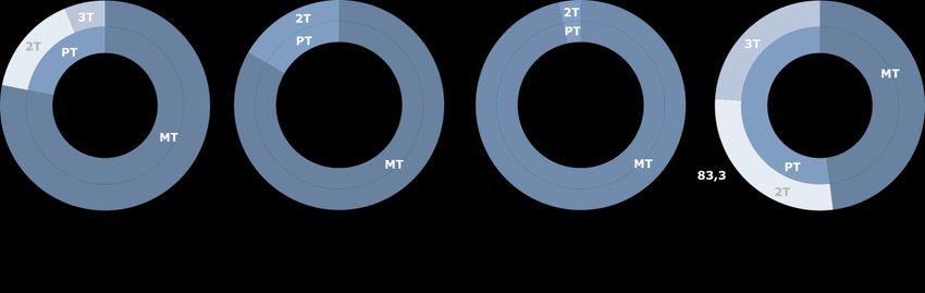
Article no. 27

                                                              THE CIVIL ENGINEERING JOURNAL 1-2021

                           -------------------------------------------------------------------------------------------------

to extensive historical descriptions of the respective events, the data are non-uniformly distributed
and frequent changes in historical development must be reflected. This brings the necessity of
selecting the topics with regard to the final processing.
The final section, Society (Chapters VI – VIII covering a total of 81 pages, or 76 pages of actual
content, respectively; presenting 25 maps), addresses social issues like migration and population
transfers, general demographic issues (national or religious structure, education, etc.) or diplomacy
and Czech footprints around the world.

Structural Analysis in Terms of Thematic Content
        This part of structural analysis evaluates the atlas work in terms of the thematic focus of
maps. For the purposes of the analysis, individual maps were typologically divided into seven
thematic categories identified by the authors. In the classification, the authors drew upon previous
studies (e.g. [3, 7]) and upon other general categorizations of maps with a thematic content (see [8]),
among other things, with respect to the comparability with the previous AACH. The aim of this
analysis was to assess the typology of maps, particularly in connection with their inclusion in the
thematically defined sections of the atlas (see the CHA concept). The chart in Figure 2 shows the
proportion of maps with a specific thematic focus in the whole atlas and within individual sections. In
the case of polythematic maps (about 22% of all the maps, see Figure 3), where the map could not
be unambiguously classified in one single category only, all topics were identified and the inclusion
in the respective category was expressed by a quotient denoting the representation of the given topic
in the map (e.g. in the case of three topics uniformly represented within one map, each of them was
expressed by one third).

Fig. 2 – Structure of the thematic focus of maps in individual sections of the atlas. Source: authors.

        The degree of the polythematic focus of maps differs significantly within individual sections
of the atlas. The thematically very narrowly defined atlas section (nearly 97% of monothematic maps)
is the section of “Time” devoted to selected chapters from military and political history. Thus, most
maps with military/war themes can be found in this section, representing mainly the issues of
prisoner-of-war camps during the First World War or the events of the Second World War. Most
polythematic maps can be found in the section of “Society”, where up to 52% of maps illustrate more
than one topic.

                                     DOI 10.14311/CEJ.2021.01.0027                                                 368
Article no. 27
THE CIVIL ENGINEERING JOURNAL 1-2021
-------------------------------------------------------------------------------------------------
Fig. 3 – The degree of polythematicity of maps in particular sections of the atlas. Source: authors.
The least elaborated thematic category is landscape and space reconstruction, to which mere
3.1% of all maps are devoted (see Figure 4), and these maps are only included in the “Space”
section, in the chapter reflecting changes in the landscape due to political and economic changes.
This result clearly shows the concept of the atlas as a work that puts more emphasis on the social
component of historical events rather than their impacts on shaping the landscape. The same
unambiguous classification applies to the maps of economic conditions or population characteristics
where the maps illustrating the topics of industry and trade or the utilization of water resources were
included in the thematic category of economic conditions by the authors, and the maps of the national
structure, migration, etc. were put in the category of population characteristics. Unlike landscape
reconstruction, however, these thematic categories very often appear in connection with other
thematic categories (e.g. cultural or political situation).
The maps of population characteristics can only be found in the “Society” section, where they
account for almost half of all maps. The population topic most frequently occurs in connection with
political topics in the chapters addressing forced population transfers during the Second World War.
In addition to migration processes (natural or forced), the maps of the national or religious structure
of the population were also included in population characteristics. The “Space” section, in turn, is
dominated (70% of all maps) by an extensive category of politics and administration, which includes
maps describing the political and territorial structure, election results, course of a revolution or
diplomatic relations. While nearly half of the maps in CHA (49.6%) focus on the issues of the political
and territorial structure, only 20% of maps elaborate this topic in AACH. On the contrary, the chapter
in AACH devoted to modern history is more oriented towards the economic situation, which is the
most addressed topic in this atlas (26.3% of maps), or the topic of landscape and space
reconstruction (12.5% of maps).
Fig. 4 – Comparison of thematic focus of maps within CHA and AACH. Source: authors.
DOI 10.14311/CEJ.2021.01.0027 369Article no. 27
THE CIVIL ENGINEERING JOURNAL 1-2021
-------------------------------------------------------------------------------------------------
Structural Analysis in Terms of Meta-Cartographic Semiotics
Another approach used by the authors is the analysis of the atlas in terms of meta-
cartographic semiotics (see [9]), i.e. analysis of the proportion of visuals, maps and texts within the
atlas and its sections, based on the graphic layout of individual pages. This analysis primarily covers
the assessment of the mutual balance of the textual (texts accompanying individual topics of the
atlas) and visual components of the atlas, including, in addition to a separate semiological category
of map, also the representation of categories of graph, photograph and map reproduction. Map
reproductions are classified as a separate category with regard to the thematic focus of the atlas.
This part of the analysis can be compared with AACH. In principle, this analysis is based on the
authors’ experience gained from the analysis of textbooks [10, 11], but also from other studies [12,
13].
The analysis investigated the spatial proportions of the above semiological categories –
maps, texts (tables are part of the text category due to their small number), visuals (graphs,
photographs, map reproductions), as well as empty (unused) space (blank pages, etc.). For the
purposes of a more accurate analysis, each page was divided into halves, thirds and quarters. This
choice was based on the setting pattern of pages (two columns and, in many places, the space is
divided into thirds with the ratio of the text to the remaining part of - one to two or two to one).
In terms of the overall concept of the atlas (for more detail see Figure 5), maps take up less
than one third of the page area of the map and texts more than one third (including tables). These
two basic categories represent more than 60% of the atlas structure leaving thus a relatively large
space for further visual accompanying material, which can be expected considering the
encyclopaedic nature of the publication. About one sixth (17%) of the volume is occupied by
photographs, and about half of this percentage (8%) by map reproductions. The absolutely marginal
part are graphs, and a relatively surprising finding is that there is approximately one tenth of the
space without any use, which is largely due to relatively strict setting patterns.
Fig. 5 – Structure of atlas sections in terms of the number of pages and proportions of individual
content components
So much for the general concept of the atlas as a whole; more interesting figures can be
obtained from a more detailed analysis of its individual sections. It is obvious that all the three
sections contain a similar percentage of the cartographic or textual content within their defined share
in the atlas, identically around two-fifths and one-quarter in the order they appear in the atlas. The
remaining 35% of the space in the section of Time and Society is mostly devoted to photographs –
map reproductions only represent a marginal item accounting for up to 2%, and graphs in the section
of Time for up to 0.5%. The section of Space, however, is laid out in a completely different way; map
reproductions represent an important source of its content comparable in scope to the textual
DOI 10.14311/CEJ.2021.01.0027 370Article no. 27
THE CIVIL ENGINEERING JOURNAL 1-2021
-------------------------------------------------------------------------------------------------
component. Here, the display of period maps complements particularly the topics devoted to the
development of the administrative division and the development of the Central European space as
such.
The above mentioned only applies to the three main chapters with cartographic contents.
The sections of Introduction and Conclusion contain practically only text (with a small percentage of
map reproductions), and, therefore, they are not included in the comparison in the bottom part of
Figure 5.
Comparing the lexical aspects with AACH Chapter V, reflecting the period of the 20th century,
we find the greatest similarity with the section of Society. To be specific, in AACH, pictures and
reproductions occupy about one third of the space, while texts account for one quarter and maps for
the remaining ca two fifths. This subdivision is similar to the last section of CHA and may reflect the
openness of the last AACH chapter to social issues like leisure, nature conservation, elections, etc.,
as AACH as a whole differs from its Chapter V quite significantly. However, the differences in the
content distribution within CHA are not so obvious to be able to draw deeper conclusions from the
analysis on this topic.
CARTOGRAPHIC ANALYSIS OF THE ATLAS
Complexity of the Map Content
In the first part of cartographic analysis, individual maps of the atlas were assessed in terms
of their content complexity. The analysis of the thematic content of maps was mostly based on a
study [14]. The whole atlas is clearly dominated by analytical maps (61.5%), whereas synthetic maps
were not identified in the atlas at all (see Figure 6). The complexity of the map content varies
considerably across individual sections of the atlas, which is mainly due to their different thematic
focus (see Figure 2). In the section of “Space” addressing in its chapters the delimitation of borders
or territorial changes, analytical maps were mostly identified (73.8%). Within this section, the close
connection of the content complexity with the typology of maps can be very well presented (see
structural analysis in terms of thematic content), which reflects the diversity of approaches on the
part of different experts (cf. historians’ and geographers’ approaches) to the presented topics.
Analytical maps dominate particularly in the first three chapters of the section (87.5%) devoted
mostly to administration and politics (91.5%), which were prepared with the participation of
historians. The only exception is Chapter IV addressing the issues of landscape changes, where, on
the contrary, 70% of complex maps can be identified. Typologically, maps with socially oriented
topics (landscape reconstruction and economic or cultural conditions) completely dominate here,
elaborated with the participation of experts from the field of social and historical geography.
Likewise, more than 75% of analytical maps can be found in the section of “Time” (see Figure
6). Compared to the previous section, however, there are many more so-called polycomplex maps,
i.e. maps containing in addition to the representation of a larger number of phenomena also links
among them (17.2%), even though this section is devoted to purely historical topics (administration
and politics or military/war themes – see Figure 2). This fact testifies, above all, to the historians’
efforts to achieve the maximally detailed and “content-complete” cartographic representation of the
respective topic, which, unfortunately, not always allows a sufficient degree of cartographic
generalization. An example of such a polycomplex map is e.g. the liberation of Czechoslovakia in
1945 (Chapter V.4). The “Society” section is completely different in terms of the map content
complexity, as complex maps (76%) absolutely predominate there. The interconnection with the
thematic focus was manifested here as well, because this section is also significantly dominated by
maps devoted to social topics like migration and population transfers or general demographic issues
(national and religious structure, education, etc.) (see Figure 2).
DOI 10.14311/CEJ.2021.01.0027 371Article no. 27
THE CIVIL ENGINEERING JOURNAL 1-2021
-------------------------------------------------------------------------------------------------
Fig. 6 – Percentage of the representation of analytical (A), less complex (MK) and polycomplex
(PK) maps in the atlas. Source: authors.
For comparison, the previous graph also shows the result of the analysis of AACH Chapter V, where
analytical maps also predominate (57.5%), like in CHA. Unlike CHA, however, at least a few
synthetic maps (3.8%) can be found there.
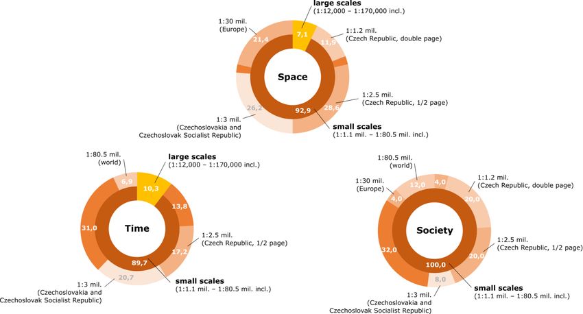
Scale Series of Maps in the Atlas
In the next part of cartographic analysis, the design of scale series in the atlas was assessed
(see Figure 7). A total of 25 different scales were identified in the atlas, of which 18 different scales
were only used for 22 maps. Although the scale of these maps differs only minimally in many cases
and the enlargement of the area to the nearest used scale would not cause the collision of the map
content with the map frame, the adopted solution is certainly a justifiable step in most cases
considering the territorial and content diversity of these maps. The illustrated topic is often related to
areas situated outside the present-day territory of the Czech Republic or the territory of inter-war or
post-war Czechoslovakia (e.g. on maps of Czech settlements in the Banat region or prisoner-of-war
camps in selected European countries or the Asian part of Russia) and thus the difference in scale
does not interfere with potential comparability in terms of spatial and temporal relationships. For
other maps, specific scales are deliberately chosen (this mainly applies to large-scale maps) due to
non-uniform coverage of the territory by the thematic content to display details of the area of interest
(e.g. in maps of US troops advance in Western Bohemia or February Communist Takeover of 25
February 1948 in Prague).
The greatest variability of map scales was identified in the section of “Time” (a total of 13
scales were used for only 18 maps, i.e. 62% of maps in the whole section), which de facto
demonstrates the diverse spatial scope of the section devoted to military and political topics related
mostly to the areas of interest of inter-war and post-war Czechoslovakia (Prague, Western Bohemia,
Slovakia) or Europe (France, Italy, Asian part of Russia, etc.). As the cartographers themselves
commented in the introduction to the atlas, this section in particular was hard to grasp in terms of
cartographic representation (Semotanová et al., 2019).
DOI 10.14311/CEJ.2021.01.0027 372Article no. 27
THE CIVIL ENGINEERING JOURNAL 1-2021
-------------------------------------------------------------------------------------------------
Fig. 7 – Representation of individual scales in the atlas and its sections. Source: authors.
The above-mentioned scale diversity can be offset by the fact that only six scales were used
for almost three quarters of maps in the atlas. The scale series has been integrated mainly for maps
of the territory of the present-day Czech Republic, interwar and post-war Czechoslovakia, which
represent more than half of the maps in the atlas allowing the atlas reader to visually compare the
spatial and temporal relationships within one topic, but also between topics.
In terms of the scale series, the least variable section seems to be “Space”, where the
cartographers only managed with eight scales (for 88% of the maps in this section and, moreover,
only four scales were used). This follows mainly from the content of the section; whose individual
chapters mostly monitor the territorial development of the chosen topic. An interesting fact is also
the use of two scales to display different topics on the territory of the Czech Republic (a total of one
third of maps) in connection with the map complexity and typology. The 1: 2.5 million scale is used
mainly in simple analytical maps (almost three quarters of maps at this scale) depicting
predominantly the topic of administration and politics (two thirds of maps at this scale). On the
contrary, the maps of the territory of the Czech Republic at twice the scale (1: 1.2 mil.) are mostly
less complex (90% of maps at this scale) and are primarily used to illustrate social topics dealing
with population characteristics (national or religious structure) or cultural issues (spa treatment,
tourism or conservation of natural and cultural heritage).
Like in AACH, small-scale maps absolutely predominate in CHA (93.8%), whereas medium-
scale maps do not appear in CHA at all (see Figure 8). A significant difference can also be found in
the use of the basic scale for depicting the territory of today’s Czech Republic and the former territory
of the Czechoslovak Republic and the Czechoslovak Socialist Republic, which primarily results from
the different format and composition of the atlas.
DOI 10.14311/CEJ.2021.01.0027 373Article no. 27
THE CIVIL ENGINEERING JOURNAL 1-2021
-------------------------------------------------------------------------------------------------
Fig. 8 – Comparison of scale numbers used within CHA and AACH. Source: authors.
Map Design and Composition
Unlike AACH, the uniformity of style was achieved. This is mainly due to the fact that the cartographic
part of the team had been involved in the activities on the atlas from the beginning of preparatory
work, thanks to which they had significantly corrected the requirements for the spatial representation
of phenomena on the part of experts in the thematic content (both historians and geographers) so
that they would be consistent with the rules of creating an atlas cartographic work. In addition to the
above scale series, considerable attention was given to the preparation of spatial data sets during
the preparatory phase of creating maps for individual sections of the atlas. The cartographers’
objective was to have data available for different scales, i.e. data with an optimum degree of
cartographic generalization.
An extensive debate of both cartographers and, partially, geographers and historians, took
place over the cartographic projections used and their unification within the whole atlas to achieve
both suitability for individual territories and not a very wide range of different projections that would
impair comparability. For all maps (except for world maps using the Robinson pseudo-cylindrical
compensating projection), the Albers equal area conic projection was used as the initial cartographic
projection, in four variants with a specific setting of the central meridian position and undistorted
parallels respecting the character of the displayed area. Compared to AACH, where a uniform
projection was used for most maps regardless of the size of the territory (Czech Republic vs. Central
Europe, Europe as a whole), this is again a significant step forward and a proof of a conceptual
cartographic design of the atlas.
An equally complex debate focused on the setting pattern of individual pages, i.e. the location
and graphic layout of map legends, the number and size of map fields and the general aesthetic
appearance, function, clarity and other attributes enhancing the usability of the atlas. Legends and
scales are already placed inside the map frame or in its immediate vicinity, a unified look of graphic
scales, map legends have been ensured, and the concept of the symbol map legend has been very
successfully processed to show the development of the results of parliamentary elections or the
religious structure allowing comparisons between individual maps and periods.
CONCLUSION
The article assesses and analyses the Czech Historical Atlas, particularly with regard to its
typology and internal structure. The logic of the sections as a vertical counterweight to the horizontal
concept of the chronology of the chapters indicates the suitability of the chosen approach, especially
in terms of the prevailing map typology and the principal topics. The results of the structural analysis
of the thematic focus of maps further indicate the suitability of the subdivision of the atlas into
individual sections, and the maps are thematically very well classified.
The classification of topics and their composition into individual units within the atlas is in contrast to
the Academic Atlas of Czech History, where the classification was, with some exceptions,
chronological and without further ambitions to unite topics into related sections. The advantage of
DOI 10.14311/CEJ.2021.01.0027 374Article no. 27
THE CIVIL ENGINEERING JOURNAL 1-2021
-------------------------------------------------------------------------------------------------
this approach, which fully respects the time aspect, is primarily in the clarity and easy orientation in
discrete topics that reflect the standard orientation towards data and timelines. However, there is a
disadvantage of mixing thematically different maps and separating visually thematically related maps
and chapters that are often very similarly cartographically processed, making it difficult for the reader
to perceive history as mutually connected and complex facts (and not as isolated events) and
compare these related topics.
The thematic structure of maps reflects the participation of historians and geographers in the
creation of the atlas. Overall, the atlas is dominated by classical history themes (military affairs,
politics/administration, genesis of space – about 70% of maps) over social themes (civic society,
migration, education, tourism, etc.), which fall under the domain of social and historical geographers
in terms of authorship. The difference in the approach of historians and geographers to the presented
topics is also clear from the results of the cartographic analysis of the atlas, which imply a close
connection between the complexity of the content and the typology of maps.
It certainly cannot be claimed that the content of the atlas as a medium is exploited to the full
– for example, the map complexity analysis shows a not very high proportion of complex maps in
some chapters, which, however, is not a state deviating in any way from the general historiographic
cartographic production. Given the complexity of some of the topics themselves, truly synthetic maps
could pose problems in the identification of the message contained in the maps. The opposite
problem, i.e. excessive filling of maps with symbols (and information in general), does not occur
either. At least not to the extent that accompanied some of the economic themes treated in its
predecessor, AACH.
The cartographic qualities of the atlas make it a balanced whole benefiting from a reasonably
coupled set of technical elements, such as cartographic projections, scales, but also e.g. the map
key style, legends and other elements. Any potential unfulfilled expectations on the part its readers
and a higher degree of user ergonomics can be compensated by the electronic version, which is
being launched to the public at the time of publishing this article.
ACKNOWLEDGEMENTS
This work was financially supported by the Ministry of Culture of the Czech Republic, the
NAKI II programme, Grant/Award Number: DG16P02H010.
REFERENCES
[1] Semotanová, E., Zudová-Lešková, Z., Močičková, J., Cajthaml, J., Seemann, P., & Bláha, J. D. et al.
2019. Český historický atlas: kapitoly z dějin 20. století. Praha: Historický ústav.
[2] Semotanová, E., & Cajthaml, J. 2014. Akademický atlas českých dějin. Praha: Academia.
[3] Bláha, J. D., & Kučera, Z. 2014. E. Semotanová, J. Cajthaml a kol.: Akademický atlas českých dějin.
Informace ČGS, 33(2): 36–46. Available from: https://geography.cz/publikace/informace-cgs/
/informace-cgs-201433-2/
[4] Český historický atlas. Internetový literární časopis iLiteratura.cz [online]. 2020, 29-03-2020, 18.(1), 1
[cit. 2021-01-25]. ISSN ISSN 1214-309X. Available from: http://www.iliteratura.cz/Clanek/42803/
/semotanova-eva-et-al-cesky-historicky-atlas
[5] Jenny, B., & Hurni, L. 2011. Studying cartographic heritage: Analysis and visualization of geometric
distortions. Computer & Graphics, 35(2): 402–411. ISSN 0097-8493.
[6] Chen, C., Härdle, W., & Unwin, A. (eds.) 2008. Handbook of Data Visualization. Springer, Berlin, 936
p. ISBN 978-3-540-33036-3.
[7] Bláha, J. D., & Močičková, J. 2018. The research-analytic part of preparation of a cartographic work:
a case study of an analysis of historical atlases as the basis for creating the Czech Historical Atlas.
AUC Geographica, 53(1): 58–69. ISSN 0300-5402.
DOI 10.14311/CEJ.2021.01.0027 375Article no. 27
THE CIVIL ENGINEERING JOURNAL 1-2021
-------------------------------------------------------------------------------------------------
[8] Slocum, T., Robert B. MacMaster, F. Kessler and H. Howard. Thematic cartography and
geovisualization, 3rd Edition. (2008).
[9] Wolodtschenko, A. 2010. Atlaskartosemiotik: neue Möglichkeiten und Lösungen. Meta-carto-
semiotics. Journal for Theoretical Cartography, 3: 1–10.
[10] Trahorsch, P., & Bláha, J. D. 2019. Visual representation of the curriculum in Geography textbooks:
Quantification of visuals in educational medium analysis. IARTEM e-Journal, 11(2): 1–20.
[11] Trahorsch, P., Bláha, J. D., & Chytrý, V. 2019. Comparative Analysis of the Quality of Visuals in
Geography Textbooks for ISCED 1 and ISCED 2 Levels of Education. Review of International
Geographical Education Online, 9(2): 264–283. ISSN 2146-0353.
[12] Houghton, H. A., & Willows, D. M. (eds.) 1987. The psychology of illustration: instructional issues.
New York: Springer.
[13] Metallinos, N., Muffoletto, R., Petterson, R., Shaw, J., & Takakuwa, Y. 1990. The use of verbovisual
information in textbooks – a cross-cultural experience. Londýn: University of London.
[14] Pravda, J. 2002. Analytické a syntetické mapy v klasifikácii máp. Geografický časopis, 54(4): 367–
380.
DOI 10.14311/CEJ.2021.01.0027 376You can also read