Strength and Weakness in geotourism: the case study of irpinia (Campania, italy) - Journals Le ...
←
→
Page content transcription
If your browser does not render page correctly, please read the page content below
Strength and Weakness in Geotourism:
The case study of Irpinia (Campania, Italy)
Russo Filippo, Sisto Michele, Magliulo Paolo & Valente Alessio
Dipartimento di Scienze e Tecnologie, Università degli Studi del Sannio (Benevento)

Keywords: Geosites; Geotourism; Irpinia, Campania, Italy

Abstract
The territory of Irpinia (Campania, Italy) has been largely preserved by the “Great Transformation” of the territory followed by the Second World War.
Its environmental peculiarities and its historical-cultural aspects have integrated into the landscape; therefore they represent attractive places for the
new directions of environmental and cultural tourism. The advantages derive from the proximity to the coast of Campania, where the global value
of tourist attractions has been known for centuries. The strengths of these internal areas of our peninsula are represented by the numerous places
capable of divulging the “geological culture” and therefore to highlight how around them have developed stories, cultures and traditions of quality.
However, there are weaknesses in the conservation and uses by tourists of these areas, as highlighted by the spread of certain geological and geomor-
phological hazards (landslides, floods, fumes, etc.). Geotourism would, therefore, be fundamental to recall the public interest on this internal area of
Campania and to encourage protection and enhancement initiatives.

Introduction

In Italy, tourism is an important part of the economy, ac-                     the cities of art (Naples with its museums and palaces, the
counting for more than 13% of GDP, as reported for the year                    Royal Palace of Caserta) (MiBAC, 2018). Each of these places,
2017 by the World Travel and Tourism Council, which analy-                     today chosen by the majority of tourists, both Italian and for-
ses the economic impact of the travel and tourism sector in                    eign, presents a seductive and sometimes almost uncontam-
the world and in the individual countries (WTTC, 2018). Statis-                inated landscape, or a geological context, unique and charac-
tical data show an increase both in the presence in the hospi-                 teristic, like that of the Campania volcanoes (Vesuvius in the
tality establishments and in the arrivals in our peninsula with                Campania coast, Mount Epomeo in Ischia, Campi Flegrei in
rates higher than the European average.                                        Pozzuoli) or that of the coasts with its many evocative forms
The southern regions, even if they are not yet in the very                     (the limestone cliffs of Capri, the terraces of the Sorrento
first places, show substantial increases in terms of presenc-                  Peninsula, the caves of Palinuro in the southern Cilento).
es, which in any case in the northern regions still absorb the                 These choices testify to the approach of tourism toward new
majority (Veneto: 16.5%, Trentino Alto Adige: 11.9%, Tusca-                    categories of value, such as the natural environment and cul-
ny: 10.9 %). Considering the revenue left on the territory by                  ture. Through them the experience lived by the tourist can
the tourists, instead, Campania succeeds among all those of                    contribute to increasing his “sense of attachment” towards
the south in attracting a meaningful percentage that imme-                     the place visited or the appropriation of the “identifying
diately puts it behind the Lazio, the Lombardy, Veneto, and                    products and/or attributes” of that territory (Gross & Brown,
Tuscany (ISTAT, 2018). Even going back in time the economic                    2008). This includes the flourishing development of cultural
value of tourism in Campania and its provinces has always                      tourism and its varieties (sustainable tourism, ecotourism,
been fundamental, even if the statistics show that it is con-                  geotourism, eno-gastronomic tourism, etc.), which as shown
centrated almost exclusively in coastal areas. In these areas,                 in various surveys conducted on samples of tourists from
the tourist flows prefer not only the holidays at sea (Cilentan                Veneto, Tuscany and Puglia, is associated to cultural herit-
coast, Ischia Island, Capri Island and Sorrento Peninsula), the                age as well as to more identity-naturalistic aspects (trekking,
archaeological sites (Pompeii, Paestum, Herculaneum) and                       crafts, wine and food production, etc.) (MiBAC, 2010). In this

                                                                                                                                                       21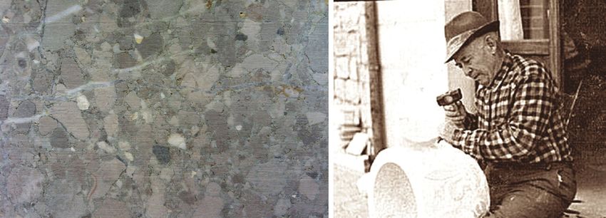
City Safety Energy                                                                            ISSUE 1 - 2018 | Geology

direction, it is possible to consistently insert the need to en-   Geotourism in Irpinia
hance the internal areas of the peninsula, such as Irpinia
(Bencardino & Marotta, 2004; Bencardino & Cresta, 2007;            Irpinia is a region of the southern Apennines, located in the
Cresta & Greco, 2010; Russo & Sisto, 2012). In the enhance-        eastern part of Campania (figure 1). It corresponds to the
ment actions of a territory, it is evident how these can be        province of Avellino (2,792 km2, 440,000 inhabitants) and its
developed around strengths represented by the spread of            territory is divided between mountain, which makes up most
large uncontaminated natural areas and by a close relation-        of it (67.9%), hill (25.1%) and plain (7.0%). Its sparsely inhab-
ship between the territory’s resources and human activities.       ited landscapes are largely preserved by the “Great Trans-
However, these actions cannot be ignored those situations          formation” (Turri, 2002) followed in the Second World War.
of the danger inherent in the territory, which could prevent       They are characterized by their natural architectures and the
the promotion and enjoyment of these places.                       singularities of the environment, which have received the im-
                                                                   print of many ancient civilizations.

Figure 1 – DTM of Irpinia in Campania: from green (lower) to brown (higher) the altimetric range. Numbers in red polygons
indicate representative geosites: 1. The Mephite in the Ansanto Valley; 2. The Mulino-garden of the sulphur mine; 3. The quarry
of "Breccia Irpina" in Serro della Serpa.

To the west and south, there are the Mesozoic carbonate            mites (Sestini, 1963). From their peaks, covered by dense for-
massifs (D’Argenio et al., 1973; Bonardi et al., 2009): thanks     ests, but also engraved by tectonics and shaped by erosion,
to their karst nature they have developed the largest un-          you have the opportunity to have panoramic views at 360°.
derground water reserves in southern Italy and also show a         On other peaks, less elevated, we find medieval castles still
wide range of landforms in the mountain landscape such as          surrounded by intact villages in their original configuration.
polje, uvala, dolines, lapiés. In the underground, an intricate    To the east, the Cenozoic clastic sediments form hills (Bonar-
system of fissures, connected to the surface forms, can open       di et al., 2009), whose slopes are frequently characterized by
up in correspondence of caves with stalactites and stalag-         strong instability with landslides of all types and sizes. How-

22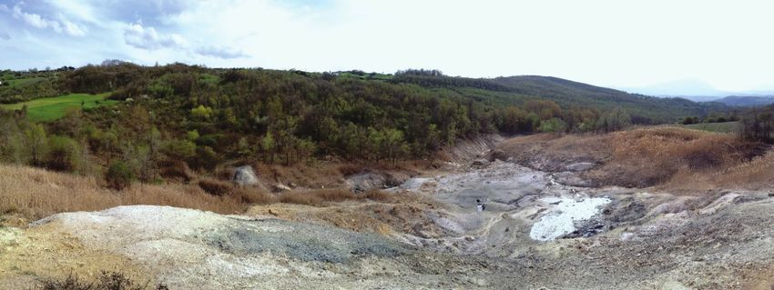
Strength and Weakness in Geotourism: The case study of Irpinia (Campania, Italy)

ever, they have also developed valuable crops (vines, olives,       values and relationships of territory, but also by landscapes
hazel groves, etc.) increasingly growing in quality and quanti-     and forms capable of amazement for their beauty and at the
ty (Bencardino & Marotta, 2004; Cresta & Greco, 2010). These        same time to tell the story of the formation of those places
hills are crossed by a dendritic hydrographic network, which        (Cosgrove & Daniels, 1988; Poli, 1999). They are related to
then flows in rivers with rather copious flow rates, such as        different aspects of geology, even if they then unfold popular
Calore, Sabato, and Ofanto. However, the plains adjacent to         traditions and dark mysteries. In these places, we find the
these rivers, where they are slightly wider, have been filled       typical landscapes of the inner areas of the Apennines (karst,
with important thicknesses of alluvial deposits and pyroclas-       terrigenous, fluvial, lacustrine, etc.), that have been the back-
tites during the Quaternary (Brancaccio & Cinque, 1988). The        ground to the secular historical events of these areas. There-
first sediments were deposited from the main rivers and the         fore, talking about geotourism in Irpinia means supporting
latter came from the Tyrrhenian volcanic centres of Som-            and amplifying the “geographical character of a place, its en-
ma-Vesuvius and Campi Flegrei.                                      vironment, culture, aesthetics, heritage and well-being of its
This description is rather brief compared to the number of          residents” (NGS, 2009). In these territories the trip allows you
physiographic types that distinguish Irpinia. This assumes          to visit places where winter sports and trekking are practiced,
a greater value because the populations and their activities        or to enjoy the wonders of architecture: from rock churches
have respected these places for years, preserving their orig-       to castles and monastic complexes, or to taste typical gastro-
inal appearance. In this effort even the secular traditions         nomic products with high-quality olive oil and wines, now ex-
and flavours of food seem not to have been contaminated             ported all over the world. It should be noted that Irpinia has
by modernity and sophistication. Moreover, the vegetation           received the DOCG (Denomination of Controlled Origin and
has taken advantage of these conditions so as to extend its         Guarantee) for three wines: Taurasi, Greco di Tufo, and Fi-
naturalness with native species of value, which are protected       ano di Avellino. This label demonstrates the achievement of
by the Natura 2000 network (20 between SIC and SPA) and by          quality and renowned product, with characteristics associat-
two regional parks (Parco del Partenio and Parco dei Picenti-       ed with the natural and anthropic environment (Bencardino
ni). For these aspects, Irpinia is a privileged place for the de-   & Greco, 2007; Cresta & Greco, 2010; Di Lisio et al., 2016b).
velopment of environmental and cultural tourism (Regione
Campania, 2008; Di Lisio et al., 2016a).                            Strength
In fact, geodiversity, like biodiversity, is of primary impor-
                                                                    In a correct assessment of human actions, there is the need
tance for new tourism, based on the need for environmen-
                                                                    to highlight the resources that the system is equipped with.
tal protection and the concept of sustainable development
                                                                    In this case, the strengths in geotourism in Irpinia are rep-
(Baker, 2006). Milestones of its concepts are the Brundtland
                                                                    resented by the numerous geosites surveyed in the Region-
Report (1987), the European Landscape Convention (2000)
                                                                    al Cadastre of Geosites since 2008 (figure 2). Such a regis-
and the Council of Europe’s Recommendation on the con-
                                                                    try was created by the Campania Region making a specific
servation and enhancement of geological heritage (Council
                                                                    reflection on the value of geoconservation in its Territorial
of Europe, 2004). Moreover, the action of the UN system on
                                                                    Strategic Plan (Regione Campania, 2008). Within it, a little
the Millennium Development Goals, by 2015, has set among
                                                                    more than 50 locations were included, surveyed on the ba-
the commitments of the Objective 15 of “Protect, restore and
                                                                    sis of a prevailing geological-stratigraphic characterization.
promote sustainable use of the terrestrial ecosystem, sus-
                                                                    In the following years, thanks also to the reformulations of
tainably manage the forests, fight desertification, stop and
                                                                    the concept of geosite (subjected to continuous revisions in
reverse the degradation of the land, and stop the loss of bi-
                                                                    a well-established specific literature), also extended to that
ological diversity”, and more “increase the capacity of local
                                                                    of geomorphosite sensu Panizza (2005), the total of the de-
communities to pursue sustainable livelihood opportunities”
                                                                    serving Irpinia geosites has been raised at 70 (Di Lisio et al.,
(United Nations, 2013). Tourism in Irpinia has the opportuni-
                                                                    2018).
ty to do so by choosing in the environment and in the culture
the guidelines of the development. This territory can offer, in     The geosites to be considered as witnesses of time, accord-
fact, very different landscapes, but also a rich cultural herit-    ing to a fortunate definition (Poli, 1999), are places, areas or
age (Panizza & Piacente 2003). It appears not contaminated,         territories in which it is possible to identify a geological or ge-
pleasant, not involved in criminal actions. That’s why, in the      omorphological interest for conservation (Wimbledon, 1996).
last decade, arrivals and presences in all types of accommo-        Moreover, they are the basic prerequisite for discussing geo-
dation have recorded marked growth. Moreover, visiting the          conservation strategies and developing products to dissemi-
Irpinia villages, many tourists often buy holiday homes.            nate the geological and geomorphological characteristics of
Along these routes, tourists are likely to feel attracted by the    the landscape to a wide public (Brilha, 2002). This assumes

                                                                                                                                    23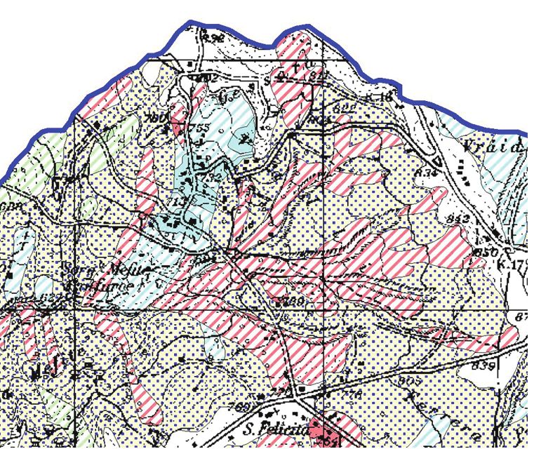
City Safety Energy                                                                                ISSUE 1 - 2018 | Geology

              Figure 2 – Excerpt from the Regional Cadastre of Geosites in Irpinia (fron Regione Campania, 2008).

more value since there is a growing interest in geosites (and         with Messinian evaporites and/or as the epicentre of the
related geotourism, a happily sustainable form of leisure/            1980 earthquake (contemporary geological literature). The
learning in the conceptual framework of the landscape): such          phenomenon has recently been linked to deep degassing
interest is finally reflected in the planning acts of local author-   processes, in the context of the articulated crustal subduc-
ities, regions, and states, and this not only in economically         tion underway in the central Mediterranean. However, this
more advanced countries but also in developing countries.             situ shows the world’s largest non-volcanic emission of CO2
In the case of Irpinia, many sites reach the definition of geo-       (Chiodini et al., 2010). The characteristic of the site (figure 3),
morphodiversity proposed by Panizza (2009) and the Princi-            located between the towns of Rocca San Felice, Frigento and
ples of Geotourism (NGS, 2009), which refer to “the integrity         Villamaina, is a pond of about 50 meters in diameter in which
of the places, the respect of the international codes, the par-       it boils grey and muddy water and from which violent poi-
ticipation of the community to the benefits, the satisfaction         son gases are released (Duchi et al., 1995). Around the pond
of tourists, the conservation and enhancement of resources,           there are other small pools, mud banks and clayey slopes
the planning and use of the territory, the educational / inter-       without vegetation from which crystals of gypsum and sul-
active fun, and finally the assessment procedures”. Among             phur emerge (Di Lisio et al., 2011; Di Lisio et al., 2014). In the
those surveyed in Irpinia, in this work, three geosites are pro-      area a shrine to the Goddess Mefite was built around the
posed as they are representative for scientific quality (Paniz-       seventh century BC, now completely destroyed, but the dis-
za, 2005) and for geological, historical and archaeological im-       covery of remains and findings (amphorae, terracotta, etc.)
portance (Pereira et al., 2007).                                      testifies its great attendance (Rainini et al., 1976; Mele, 2008).
                                                                      For this archaeological value, it is considered among the 101
The Mephite in the Ansanto Valley                                     archaeological sites of Italy, a place in which to go at least
This geoarchaeosite (sensu Lena, 2009) is one of the flag-            once in life (Ardito, 2013), however, the Mephites does not
ships of Irpinia’s geological heritage (Di Lisio et al., 2010: Di     hide its intrinsic dangers (exhalations, active or quiescent
Lisio et al., 2014), is known and frequented for millennia,           landslides on the surrounding slopes) that may not favour the
so as to be worthy to receive important literary quotations.          full enjoyment of this geosite. Despite this, it indirectly confers
Over the centuries it has been variously interpreted as the           added value to all the crops and dairy production in the area,
mouth of Hell (Latin literature of the classical age), as an ex-      which have already obtained recognition and protections re-
tinct volcano arranged on the Vulture-Vesuvius alignment              garding typical local products. The happy union between the
(seven-nineteenth-century naturalistic literature), as a man-         spectacular geological phenomenology, the high historical-ar-
ifestation of resurgences of deep fluids enriched by contact          chaeological value and the agro-food typicality make it a true

24
Strength and Weakness in Geotourism: The case study of Irpinia (Campania, Italy)
Figure 3 – The Mephite of the Ansanto Valley.
paradigmatic example of how a geosite can trigger virtuous an economy based on sulphur, so as to recall on the spot
paths of sustainable tourism, acting as a driving force for the emigrants from Abruzzo, Molise, and Romagna: the precious
economic growth of an entire territory (Di Lisio et al., 2014). resource was used both in commerce and in agriculture, with
transport on cart or rail in all the neighbouring regions. In
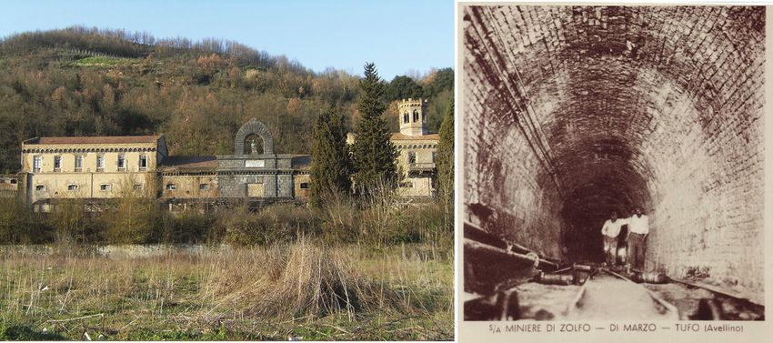
The Mulino-garden of the sulphur mines (figure 4) 1971 the crisis began and the number of workers was dras-
The Altavilla and Tufo (AV) mines exploit sulphur deposits tically reduced. At the beginning of the Nineties, the mining
present in the arenaceous-clayey-chalky succession of the activity ended up leaving an industrial complex, which pre-
Upper Messinian (Altavilla Formation: Bonardi et al., 2009), serves the main elements of the factory from the milling and
approximately built up 5.5 million years ago. At that time the refining of the raw ore to the internal transport with trolleys
waters of the Mediterranean evaporated almost completely, to the storage and preparation for the shipment of the min-
due to the closure of the Strait of Gibraltar, for which the con- eral ready for use (Del Prete, 2011). In recent years the pub-
ditions of deposition of this mineral were created. Its discov- lic administrations of the area have started the recovery of
ery in these areas and its subsequent cultivation dates back the industrial and mining complex of the Mulino-Giardino di
to 1860, and since then this mining activity has played a role Tufo, also because in this area the lands are widely used for
of great importance for the Irpinia economy (Di Lisio et al., the rows of DOCG Greco and Fiano wines. For tourists visit-
2014). The extraction of the mineral, taken from a man-pow- ing there is the opportunity to recover a close relationship
er until then exclusively peasant, allowed the flourishing of between resources and human activity (Amato et al., 2010).
Figure 4 – The sulphur mines of Tufo (Avellino); on the left the monumental buildings before restoration and on the right the
entrance to the underground galleries.
25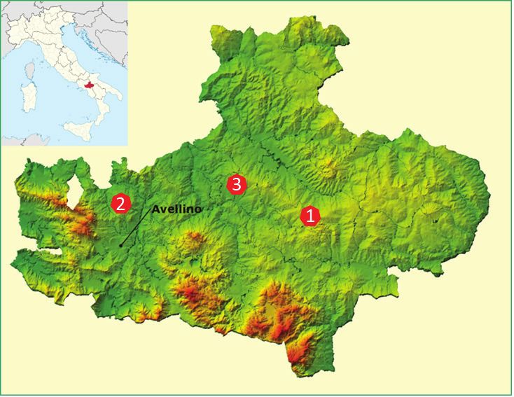
City Safety Energy                                                                                  ISSUE 1 - 2018 | Geology

The quarry of “Breccia Irpina” in Serro della Serpa (figure 5)         of ruditic limestone of varying thickness, sometimes crossed
The well-known lithotype commercially called “Breccia Irpi-            by laminated layers of clays (Flysch Rosso: Cretacico Inferi-
na” has long been of considerable appeal, and not only local-          ore – Oligocene, Bonardi et al., 2009). Today the extraction of
ly (Allocca et al., 2010). Furthermore, for centuries it has con-      this precious material proceeds at alternate rhythms, both
stituted one of the most sought-after ornamental stone for             because many quarries are about to run out, and because
the production of precious pieces and decorations, present             many are closed or difficult to open for reasons of environ-
in the most famous historical buildings and sacred buildings           mental protection. However, there is the willingness of some
of Irpinia and outside it (Ciarcia et al., 2013). From the au-         of these workers to pass on this centuries-old ability of man
thorized quarries of Sant’Andrea di Conza and Pescopagano              to work an important stone resource in these lands through
it is extracted in a compact form, with a granulometry typical         the promotion of their “shops”. Its easy workability, its high
of the breccias in carbonate matrix, whose market price is             wear resistance and sliding friction (Del Gaudio & Vallario,
directly proportional to the size of the clasts and the variety        2007), makes a stone widely used in construction and for
of coloration. According to the sites, in fact, this material is       the construction of internal and urban furnishings. Recog-
identified as “favaccia, favaccino, brecciato, stone of Fontan-        nizing these geological materials in the historical heritage
arosa, stone of Gesualdo” (Ciarcia et al., 2013). More specifi-        built in Irpinia contributes to establishing interdisciplinary
cally, these are sedimentary deposits affecting a structurally         approaches and even imagining prospects for social and eco-
complex formation, which is presented in layers and banks              nomic re-evaluation.

                  Figure 5 – Example of a slab of Breccia Irpina (on the left) and a worker of the stone (on the right).

Weakness

If the structure of Irpinia with its geodiversity makes it possi-      (NA) and the Maccalube di Aragona (AG) occurred in 2017
ble to emphasize the nature of the trip and the visit to a place,      and 2014, respectively. Such events are terrible testimonies
it is equally true that there is a relationship between the geot-      of how the underestimation of intrinsic dangers can then be
ourist use of a site and its natural or induced dangerousness          turned into manifest damage to people, to cultural/environ-
human activity (Panizza, 2005; Brandolini et al., 2007; Rey-           mental asset or to natural resource (water, soil, forest, etc.),
nard et al., 2016). This danger is linked to the conformation          to property (land, buildings, etc.) and to the productive ca-
of the place, which can be accentuated by human behaviours             pacity of an activity (industry, farm, etc.).
not suitable for the natural processes that develop there, to          The concept of risk has been repeatedly defined and is still
the point of triggering or accelerating its occurrence. There-         the subject of reflection in various fields of application, not
fore, even in a geosite, there is the probability that a poten-        least those of technical regulations. But referring to the well-
tially destructive event occurs in an area (e.g. crags collapse,       known proposal of the UNESCO report by Varnes D.J (1984),
poison fumes, etc.) with a certain intensity that can damage           the risk is expressed by the relationship between different
the user and/or the consistency of the place.                          components, all probabilistically linked to the interaction
Recent and painful news stories have shown how the use                 between phenomenon/event and human society (people,
of a geological and environmental asset can be risky, as ev-           buildings, infrastructures, economic activities).
idenced by the Italian tragedies of the Solfatara di Pozzuoli          According to this interaction, geotourism could be weakened

26
Strength and Weakness in Geotourism: The case study of Irpinia (Campania, Italy)

if it did not consider the nature of the possible risks to which    ous elements of danger have been highlighted, which for the
a geosite or geomorphosite could be subjected. It could be          various geosites can show common characters or peculiar
damaged at the point of its complete destruction but, at the        characteristics (Table 1). For anthropic risks, a further distinc-
same time, the estimated risk could potentially compromise          tion is proposed between risks connected to the commercial
its own function in thr coincidence of a particular danger          exploitation of the georesource available in the geosites and
(for example, poisonous fumes, explosions, collapse, floods,        risks inherent to geotourist use of the same places (Table 2).
etc.). Moreover, the lack of consideration of risks or obser-       As it is possible to read the natural phenomena, which can
vance of the safeguard rules would detract from the pres-           determine a risk condition, they also develop around the
tigious magazine National Geographic Traveler, which claims         site. For example, the Mefite is placed in an area at high risk
that geotourism represents the evolution of “sustainable            of landslide due to the physical-mechanical conditions of the
tourism”, that is to guarantee future generations to enjoy          outcropping land (figure 6), while the sulphur mines of Tufo
that environmental good (NGS, 2009).                                are on the right embankment of the river Sabato and there-
To highlight these weaknesses in geotourism, the three Irpin-       fore subjected to a possible flood (figure 7). In the latter case,
ia geosites, previously described, have been taken. These           it should be said that as the river in its engraving allowed the
places of extreme geological interest are proposed among            cultivation of the ore body in the same way it could remove
others for the particular combination created between natu-         the possibility of visiting these places where man has been
ral and human resources, but also for their marked exposure         able to extract a resource for more than a century. Also in
to the dangers that are present in them.                            the Sant’Andrea di Conza geosite the alteration of the cal-
In this choice, we wanted to investigate situations with levels     careous breccias could determine instability conditions on
of probability of occurrence more marked than relatively less       unused walls. The degree of danger of these risks, as well
critical situations. The identified risks have been distinguished   as others, could find suitable mitigation if there was careful
in natural and anthropic types. For the natural risks, the vari-    and responsible management of the site and of the territory.

Figure 6 – Excerpt of the map of the Landslide Risk in the Mephite of the Ansanto Valley (from the Authority of the Liri Ba-
sin Garigliano Volturno, 2006). Note that the areas with pink diagonal lines are affected by triggering, transit and landslide
invasions with the probability of maximum intensity; areas with celestial diagonal lines are areas that fall within quiescent
landslides with the probability of medium intensity; the areas dotted on a yallow background are area of possible expansion
of landslides.

                                                                                                                                   27
City Safety Energy ISSUE 1 - 2018 | Geology
Figure 7 – Planimetry of the external site of the sulphur mines of Tufo (AV) developed on the right bank of the Sabato River and
therefore in an area at risk of flooding.
Figure 8 – Processing area of the Irpinia Breccia adjacent to the exhibition sites.
28Strength and Weakness in Geotourism: The case study of Irpinia (Campania, Italy)
Table 1 – Natural Risks
Geosite Municipality Risks related to various dangers.
• potentially deadly exhalations;
Rocca San Felice
The Mephites in the Ansanto Valley • landslides due to high instability of terrigenous deposits around the site
(Avellino)
(damage to access roads, inadequate settlement of the surrounding slopes).
• falls in the tunnels;
Tufo • exhalations in the mines area;
The Mulino-garden of the sulphur mines
(Avellino) • sudden explosions in the mines area;
• Sabato river floods.
The quarry of “Breccia Irpina” in Serro Sant’Andrea di • stone elements falls on abrupt and unequipped walls;
della Serpa Conza (Avellino) • alteration phenomena in the quarry area.
Another category of risks concerns the anthropic action that sulphate, even if now ceased for a few decades, has certain-
takes place on the site and in its immediate surroundings, as ly partially altered the morphological profile triggering the
illustrated in Tab. 2. In order to better intervene on the an- instability phenomena highlighted. For the active quarry of
thropic risk, as already mentioned, it has been preferred to Serro della Serpa (figure 8), the cultivation takes place on a
distinguish it in that linked to the exploitation of the geo-re- limited stone body of “breccia irpina”, likely with the current
sources available on the sites (i.e. stone processing in the withdrawal rates will result in the disappearance of the litho-
quarry), and the one connected to the geotourist use of the type and, jointly, the disfigurement of the area, in absence of
same places (i.e. visit to the “exhibition shop” of the stones adequate environmental restoration measures.
annex to the quarry) (figure 8). As far as geotourist use is concerned, all the sites considered
In the three geosites, it is possible to underline how the an- could be subject to unsustainable behaviour, if not subject to
thropic action has modified the natural order of the places. monitoring and surveillance, as well as to documentary in-
For example, in the sulphur mines of Tufo, now inactive, the formation, containing rules aimed at safeguarding the site. In
construction of tunnels in the underground for four levels particular, in the case of the Mefite one could even imagine
and 3 km in length, all armed with timber due to the con- predators of archaeological material, or improper disposal
struction of the extraction routes, may have led to a “loosen- or guilty of waste of any kind. In the other two sites, since
ing” of the compactness of the rock mass. On the other hand, the entire area has not been visited, it will be better to avoid
in the narrow valley of the Mefite sulphur, mud, and gypsum access to the former gypsum mine or near the working area.
Table 2 – Anthropic Risks
Risk types
Geosite Municipality
linked to commercial exploitation linked to geotourist use
• quiescent risk for previous quarry ex- • unsustainable and / or predatory behaviour
The Mephites in the Rocca San Felice ploitation; (removal of archaeological and numismatic
Ansanto Valley (Avellino) • triggerable risk for unsuitable mainte- heritage, abandonment of waste, etc.)
nance and site protection.
• quiescent risk for previous mines ex- • collapse of the underground extraction system;
The Mulino-garden of the ploitation; • risk deriving from the rests of the extraction
Tufo (Avellino)
sulphur mines • triggerable risk for unsuitable mainte- plants still present in the area
nance and site protection. • unsustainable behaviour.
The quarry of “Breccia Sant’Andrea di • exhaustion of the outcropping lithotype; • incompatibility with extractive use still active;
Irpina” in Serro della Serpa Conza (Avellino) • landscape degradation of the area. • unsustainable behaviour.
The knowledge and estimation of the risk linked to that should keep in mind this priority, so that it can be enjoyed in
phenomenon, however, makes it possible to identify the safety, without underestimating for incapacity or worse, for
priorities of intervention to be implemented to reduce the bad faith, the possible consequences of its fruition, more or
likelihood that the risk will turn into damage. This mitigat- less massive.
ing action is strictly fitting with the use of an environmental Finally, possible standard proposals have been made to mit-
resource, as a geosite, which preserves intact its geological igate the risks identified in the specific areas of study, but
and geomorphological characteristics more than any other which can be adopted in any context in order to avoid dan-
place. The managing assets of the environmental resource gerous situations that could lead to probable damage.
29City Safety Energy ISSUE 1 - 2018 | Geology Discussion and Conclusion Geoturism in Irpinia would allow the dissemination of the the relationships that bind living beings with the features of “geological culture”, highlighting the values and relations of the Earth, even using pre-established routes or taking advan- territory and highlighting the criticalities and vulnerabilities tage of celebratory manifestations (Panizza & Piacente, 2003; for its protection. The knowledge of the elements constitut- Russo & Sisto, 2012; Di Lisio et al 2016a). ing the geological heritage is the starting point, as it would These considerations can be applied in Irpinia for three es- make it possible to present to the curiosity of tourists the dif- sential conditions: a) the growth of cultural demand and ferent lithological and morphological forms of the territory, tourist flows, even beyond financial availability; (b) the pres- as well as their formation (Poli, 1999; Dowling & Newsome, ence of millions of tourists on the coast of Campania, and 2008; Alberts & Hazen, 2010). This informative and documen- therefore the possibility of reaching the internal areas of the tal aspect, perhaps with the installation of particular panels Apennines with a short trip; c) the existence of a large num- and visual supports, becomes essential for the promotion of ber of qualified geosites near other high quality attractions geotourism. Immediately afterwards the connections with (biodiversity, castles and monumental palaces, DOCG and the other natural and anthropic aspects that make up the DOC wines, DOP gastronomic products, etc.) (figure 9). territory are to be considered. This will allow us to discover Figure 9 – Geotourism map of the province of Avellino (proposed in Di Lisio et al., 2014) in which are identified geosites close to other high-quality attractions of the territory. However, in order to achieve significant feedback in geotour- For this reason, in the management of geosites, it is strategical- ism, there is a need to develop cultural and tourism market- ly useful to consider measures or interventions aimed at mit- ing, which satisfies the demand of tourists through an ad- igating the reported risks. If for all the sites it seems obvious equate and sustainable offer. An approximate or incorrect a protection of the area, to be implemented in the forms pro- promotion of these itineraries and an absent or complex use vided for by law to protect natural and landscape assets, we of these resources cannot guarantee the result and not even also propose installations of video surveillance systems and the protection from possible risks (Brandolini et al., 2007; Al- fence areas, with appropriate reporting of existing risks and berts & Hazen, 2010). boundary of equipment for tourism purposes (Dowling, 2008). 30
Strength and Weakness in Geotourism: The case study of Irpinia (Campania, Italy)

More burdensome but strictly necessary interventions are              situ of the outcrop of the known stone material extracted
also those concerning the regulation of the outflow rods,             therein.
adoption of containment systems with naturalistic engineer-           The above descriptions are only proposals to make the three
ing techniques (in particular the Mefite) and the removal,            representative geosites of Irpinia more accessible and saf-
where possible, of pylons (visual pollution/landscape). At            er to the “general public”. However, giving space to the ge-
the same time, in the Apennine areas, already unfortunate-            ological culture also means diversifying the offer, including
ly largely subject to this type of installation, it would be to       various activities suitable for schools, families, sports enthu-
propose a total prohibition of further wind power plants, so          siasts, lovers of traditions and so on. To this end it will be
widespread on these Apennine reliefs.                                 good to produce information material suitable for the public
For the sulphur mines, in part already providentially imple-          to which it is addressed, giving priority to the graphics part
mented, the recovery and restoration of the entire industrial         (Di Lisio et al., 2016b). Alongside this promotion of knowl-
and mining complex would be accelerated, with the crea-               edge with scientific criteria, it will be possible to develop geo-
tion of a centre for tourism and, in the vicinity, a museum of        tourist-cultural itineraries aimed at enhancing the resources
eno-gastronomy. In fact, a very high-quality wine like, as the        of the territory through educational-educational paths. This
Greco di Tufo DOCG, could be developed from the character-            type of tourism generally requires longer stays, because
istics of the land. Such interventions could be accompanied,          the times of the discovery of the mountain and hilly land-
as in many examples of similar geosites, by partial recoveries        scape are slower, as indicated by research by CENSIS (2003).
of the mining tunnels, as well as partly looted furniture and         Therefore, this consideration could also incentivize accom-
machinery, to create a Museum of industrial archaeology               modation businesses and allow travel agents to find new job
(figure 10).                                                          opportunities (Bencardino & Marotta, 2004; Cresta & Greco,
Finally, for the active quarry of Serro della Serpa, it is suggest-   2010). All this will make Irpinia become a tourist reference
ed a partial halt of the extraction activity or, as a safeguard       pole, and consequently a flywheel for the entire economic
measure, an isolation for geo-tourism purposes of a more              system, but it is necessary that the territory should not be
or less extensive part of the quarry areas, as a testimony in         found unprepared (Baker, 2006; Raynard et al., 2016).

           Figure 10 – Example of restoration project of the Mulino Giardino of the sulphur mines in Tufo (Avellino).

                                                                                                                                     31
City Safety Energy ISSUE 1 - 2018 | Geology References Alberts H.C., Hazen H.D. (2010), Maintaining authenticity and integrity at cultural world heritage sites. Geographical Review, 100, 56-73 Allocca F., Calcaterra D., Calicchio G., Cappelletti P., Colella A., Langella A. & De’ Gennaro M. (2010), Ornamental stones in the cultural heritage of Campania region (southern Italy). In: R Prikryl and A Torok (Eds.) Natural Stone Resources for Historical Monuments, Geological Society of London, Special Publications 333, 221-231 Amato V., Ciarcia S., Pellino R. (2010), L’itinerario geoturistico di Tufo (AV): viaggio nella geologia delle miniere di zolfo e del terroir del Greco di Tufo, Notiziario G&T, 4, 3-7. Ardito S. (2013), 101 luoghi archeologici d’Italia dove andare almeno una volta nella vita, Newton Compton Editori. Autorità di Bacino dei fiumi Liri Garigliano Volturno (2006), Piano Stralcio per l’assetto idrogeologico, Carta degli scenari di Rischio Frane, Comune di Rocca San Felice. Baker S. (2006), Sustainable Development, Routledge, London and New York. Bencardino F., Greco I. (2007), Ripensare il rapporto tra turismo e territorio. In: Bencardino F, Prezioso M. (eds.), Geografia del turismo, McGraw-Hill, Milano. Bencardino F., Marotta G. (2004), Nuovi turismi e politiche di gestione della destinazione. Prospettive di sviluppo per le aree rurali della Campania, Franco Angeli, Milano. Bencardino M., Cresta I. (2010), L’evoluzione quanti-qualitativa dei flussi turistici: il movimento turistico in Campania. In: Ben- cardino F. (ed.) Turismo e Territorio. L’impatto economico e territoriale del turismo in Campania, Franco Angeli, Milano. Bonardi G., Ciarcia S., Di Nocera S., Matano F., Sgrosso I., Torre M. (2009), Carta delle principali Unità cinematiche dell’Appen- nino meridionale. Nota illustrativa. Italian Journal of Geosciences, 128, 47-60. Brancaccio L., Cinque A. (1988), L’evoluzione geomorfologica dell’Appennino campano-lucano. Mem. Soc. Geol. It., 41, 83-86. Brandolini P., Farabollini P., Motta M., Pambianchi G., Pelfini M. & Picazzo M. (2007), La valutazione della pericolosità geo- morfologica in aree turistiche, In: Piccazzo M., Brandolini P., Pelfini M. (eds), Clima e rischio geomorfologico in aree turistiche, PATRON, Bologna. Brilha J. (2002), Geoconservation and protected areas, Environmental Conservation, 29 (3), 273-276. CENSIS (2003), Il valore della montagna, Milano, F. Angeli. Chiodini G., Granieri D., Avino R., Caliro S., Costa A., Minopoli C., Vilardo G. (2010), Non volcanic CO2 earth degassing: Case of Mefite d’Ansanto (Southern Apennines), Italy. Geophysical Research Letters, vol. 37, L11303. Ciarcia S., Vitale S., Langella A., Calcaterra D., Colella A., De Gennaro M. (2013), La Pietra di Fontanarosa. In: de Gennaro M., Cal- caterra D., Langella A. Vari. (eds.), Le Pietre Storiche della. Campania. Dall’oblio alla riscoperta, 373-378, Luciano Editore, Napoli. Cosgrove D. & Daniels S. (1988), The Iconography of Landscape. Essays on the Symbolic Representation. Design and Use of Past Environments, Cambridge, Cambridge University Press. Council of Europe (2004) Recommendation on the conservation and enhancement of geological heritage, available on site URL http://jncc.defra.gov.uk/pdf/councilofeurope1.pdf Cresta A., Greco I. (2010), Luoghi e forme del turismo rurale. Evidenze empiriche in Irpinia. Franco Angeli Edizioni, Milano Del Gaudio A., Vallario A. (2007), Attività estrattive: cave, recuperi, pianificazione. Liguori editore, Napoli Del Prete R. (2011) - Il paesaggio minerario delle aree interne della Campania: le miniere del Sannio e dell’Irpinia. Patrimonio Industriale, V (8), 91-94. 32
Strength and Weakness in Geotourism: The case study of Irpinia (Campania, Italy)

D’Argenio B., Pescatore T. & Scandone P. (1973), Schema geologico dell’Appennino meridionale (Campania e Lucania), Acc.
Naz. Lincei, 183, 49-72.

Di Lisio A., Iscaro C., Russo F. & Sisto M. (2016a), Geotourism and Economy in Irpinia (Campania, Italy), Rend. Online Soc. Geol.
It., 39, 32-75.

Di Lisio A., Iscaro C., Russo F. & Sisto M. (2016b), La Carta Geoturistica della Provincia di Avellino (Campania): un esempio di
interazione virtuosa tra SIT e Geoturismo. Rend. Online Soc. Geol. It., 39, 121-124.

Di Lisio A., Magliulo P., Sisto M., Valente A. (2018), I geositi dell’Irpinia: inventario e proposta di classificazione. In: Bentivenga
M. (ed.), Il Patrimonio geologico: dallo studio di base al geoturismo sostenibile, Sasso di Castalda (PZ), 26-27 aprile 2018.

Di Lisio A., Russo F., Sisto M. (2010), Storia geocartografica di un monumento naturale dell’Appennino Sannita: il geosito della
Mefite nella Valle d’Ansanto (Campania), in: Territori emotivi. Geografie Emozionali. Genti e luoghi: sensi, sentimenti ed emozi-
oni, a cura di Persi P., V Convegno Internazionale sui Beni Culturali e territoriali, Fano (PU), 4–6 settembre 2009, 137-146.

Di Lisio A., Russo F. & Sisto M. (2011), La via del gesso. Proposta di un itinerario geoturistico alla scoperta delle evaporiti del
Messiniano in Irpinia (Campania), Geologia dell’Ambiente, 2, 411-419.

Di Lisio A., Russo F. & Sisto M. (2014), La Mefite nella Valle d’Ansanto (Irpinia, Campania): il valore paradigmatico di un geoar-
cheosito, Geologia dell’Ambiente, 3, 2-7.

Di Nocera S., Imperato M., Matano F., Stanzione D.E., Valentino G.M. (1999), Caratteri geologici ed idrogeochimici della Valle di
Ansanto (Irpinia Centrale, Appenino Campano-Lucano). Boll. Soc. Geol. It., 118, 395-406.

Dowling R. (2008), The Emergence of Geotourism and Geoparks. Journal of Tourism, IX (2): 227-236.

Dowling R.K., Newsome D. (2008), Geotourism. Proceedings of the Inaugural Global Geotourism Conference, Discover the
Earth Beneath our Feet, Fremantle, Western Australia, 17-20 August 2008. Promaco Conventions Pty, Ltd.

Duchi V., Minissale A., Vaselli O., Ancillotti M. (1995), Hydrogeochemistry of the Campania region in southern Italy, Journal of
Volcanology and Geothermal Research, 67, Issue 4, 313-328.

Gross M.J. & Brown G. (2008) - An empirical structural model of tourists and places: Progressing involvement and place attach-
ment into tourism. Tourism Management, 29 (6), 1141-1151.

ISTAT (2018), Conti economici regionali, Campania. available on site URL http://www.istat.it/dati/dataset

Lena G. (2009), Geositi e archeologia, Geologia dell’Ambiente, 2, 7-10.

Mele A. (2008), Il culto della dea Mefite e la Valle di Ansanto. Ricerche su un giacimento archeologico e culturale dei Samnite-
sHirpini. Elio Sellino Editore, Avellino.

MiBAC - Ministero per i Beni e le Attività Culturali (2010) - II turismo culturale: nuovi orientamenti di sviluppo economico-so-
ciale. Edizioni Mirabilia, Milano.

MiBAC - Ministero per i Beni e le Attività Culturali (2018), I dati definitivi sul turismo culturale nelle città italiane, Ufficio di Sta-
tistica, available on site URL http://www.statistica.beniculturali.it/

NGS - National Geographic Society (2009), About Geotourism, available on official site URL http://www.nationalgeographic.
com/travel/sustainable/about_geotourism.html

Panizza M. (2005), Manuale di Geomorfologia applicata, F. Angeli Editore, Milano.

Panizza M. (2009), The Geomorphodiversity of the Dolomites (Italy): A Key of Geoheritage Assessment, Geoheritage, Spring-
er-Verlag, 1, 33-42.

Panizza M. & Piacente S. (2003), Geomorfologia culturale, Pitagora Ed., Bologna.

                                                                                                                                       33
City Safety Energy ISSUE 1 - 2018 | Geology Pereira P., Ínsua Pereira D. & Alves M. I. C. (2007), Avaliação do Património Geomorfológico: proposta de metodologia, Publi- cações da Associação Portuguesa de Geomorfólogos, Vol. V, APGeom, Lisboa, 235-247. Poli G. (1999), Geositi. Testimoni del tempo, Edizioni Pendragon. Rainini I., Bottini A., Isnenghi Colazzo S. (1976), Valle d’Ansanto. Rocca S. Felice (Avellino). Il deposito votivo del santuario di Mefite. NSA, s. VIII, 30, 359-524. Regione Campania (2018), Dati flussi turistici available on site URL http://www.rilevatoreturistico.regione.campania.it/EPT/ home.do Regione Campania (2008), Piano Territoriale Regionale, Progetto Geositi. available on site URL http://www.difesa.suolo.re- gione.campania.it/ Reynard E., Coratza P. & Hobléa F. (2016), Current Research on Geomorphosites, Geoheritage, 8, (1), 1-3. Russo F. & Sisto M. (2012), Valorisation culturelle et économique à travers le Géotourisme d’un territoire marginal : l’Irpinie (Campanie, Italie). In: C. Giusti (Eds), Volumes des Actes du Colloque international de Géomorphologie «Géomorphosites 2009: imagerie, inventaire, mise en valeur et vulgarisation du patrimoine géomorphologique. Publisher: Université Sorbonne Paris, 287-293. Sestini A. (1963), Il paesaggio, vol. VII, Collana “Conosci l’Italia”, Touring Club Italiano, Milano. Turri E. (2002), La conoscenza del territorio, Marsilio, Padova. UNWTO (2017), World Tourism Barometer. Facts & Figures, available on site URL http://www.unwto.org/facts/eng/barometer.htm United Nations (2013), Millennium Development Goals, available on site URL https://www.un.org/millenniumgoals/bkgd.shtml Varnes D.J. (1984), Landslide hazard zonation: a review of principles and practice, Natural hazards, 3, 63 pp. Wimbledon W.A.P. (1996), Geosites - a new conservation initiative, Episodes 19, 87-88. WTTC – World Travel & Tourism Council (2018) - Travel & Tourism - Economic Impact, London. 34
You can also read