Streets, Parks and Lanes of Collingwood - Collingwood Historical Society, Inc - (Abbotsford, Clifton Hill and Collingwood)
←
→
Page content transcription
If your browser does not render page correctly, please read the page content below
Streets, Parks and Lanes of
       Collingwood
    (Abbotsford, Clifton Hill and Collingwood)

                 Karen T Cummings

Collingwood Historical Society, Inc
                      2021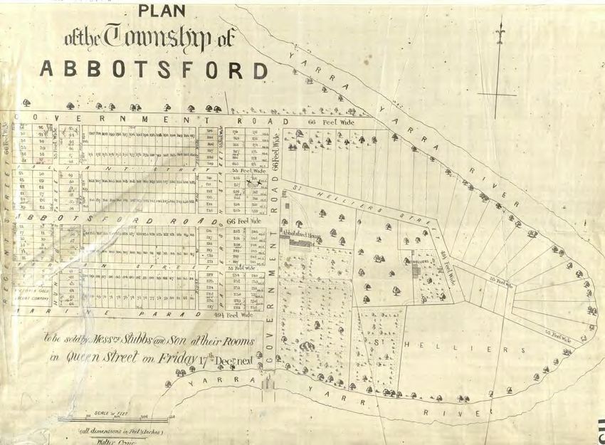
Foreword
This publication updates and expands a previous publication by the Collingwood Historical
Society, Streets of Collingwood (1991). This edition incorporates more streets and parks as
well as considerable additional information which has since come to light.
The streets and parks have now been divided alphabetically into three sequences (Abbotsford,
Clifton Hill and Collingwood). If you are searching for a particular street name but are unsure
which section the street falls into, you can use the PDF search facility to find it.

Illustrations
Most photographs, plans and maps are courtesy of the State Library of Victoria. Details can be
found in the Sources section at the end of the document.

Researched and written by Karen T Cummings with the assistance of other members of the
Collingwood Historical Society.
Published 2021 by Collingwood Historical Society, Inc PO Box 304 Clifton Hill 3068
www.collingwoodhs.org.au

© Copyright 2021 Collingwood Historical Society, Inc

Collingwood Historical Society                                                                1
Introduction
How often do you stop to think about how your street got its name, or why it starts and ends
where it does? The former City of Collingwood (incorporating Abbotsford, Clifton Hill and
Collingwood) has its history written in its streets and the more one discovers about its past,
the more meaningful the names and layout of the streets become.
At the end of 1838, only three years after the first European colonisation of Melbourne, the
land which was to form much of the City of Collingwood was subdivided into portions to be
sold by government auction in 1838–39. The area was not originally envisaged as urban:
portions were around 25 acres each. The only reserves kept for roads were those on the
boundaries, that is, the streets now known as Victoria Street, Smith Street, and Alexandra
Parade, and also Johnston, Hoddle and Church Streets.
This illustration from Bernard Barrett’s The inner suburbs shows the original portions prior to
any further subdivision.

The purchasers were:
 52 & 53 Stuart A Donaldson      54 & 55 JD Lyon Campbell         56 Hughes and Hosking
 57 Charles Nicholson            58 William Bradley               59 Charles Nicholson
 60 Stuart A Donaldson           61 W Lonsdale                    62 John Thomas E Flint
 63 William Richardson           64 Henry Smyth                   65 & 66 Dieter L Campbell
 67 JD Lyon Campbell             68 Stuart A Donaldson            73 George Otter
 74 David Chambers               75 John Terry Hughes and John Hosking
 76 Charles James Garrard        77 Henry Smyth (May 1839)        78 Ranulph Dacre
 79 JDL Campbell                 80 & 81 John Terry Hughes and John Hosking
 86 James Stewart Ryrie          87 Archibald Mosman              88 John Dight

Collingwood Historical Society                                                                    2
It was not long before some landowners began subdividing their landholdings or selling them
on to others who did so. Until 1855, the main roads were the responsibility of Victoria's
Central Roads Board while any minor roads were the responsibility of residents. The further
development of streets did not proceed in a planned or orderly fashion. Looking at the
illustration of the original portions, and the list of different owners, it becomes obvious why
much of Collingwood ended up composed of short streets, provided by landholders when they
subdivided their own piece of land, with no regard for overall design within the suburb.
Subdividers were interested in profits and so usually tried to fit the maximum number of plots
onto their parcel of land, without reference to what might be done on the next subdivision.
The 1850s were a boom time for subdivisions as Victoria's population swelled in response to
gold fever. This illustration from Barrett’s The inner suburbs shows the status of subdivisions in
the early 1850s.

East Collingwood was proclaimed a municipality in 1855. Clement Hodgkinson, District
Surveyor, later Surveyor-General of Victoria, was appointed Honorary Surveyor for the
municipality and undertook a number of surveys. The Office of the Commissioner of Crown
Lands and Survey issued, on 27 April 1857, a list of 97 streets which fixed the breadth of the
carriage and foot ways of the said streets. A map indicating streets and buildings as of 1
January 1858 was eventually published (link below).

The new Council was faced with the problem of streets which did not meet up and over time
had to buy up properties in order to rationalise street alignments. Some streets were also
hampered in their development by the poor drainage of many parts of the Collingwood flat,
indicated rather charmingly on Barrett’s first sketch map by reedy marsh plants. As early as
1856 it was proposed at a Collingwood Council meeting that an Improvements Committee be
appointed to report on the best means of extending the existing lines of streets and the
formation of new ones for opening up direct communications. This problem remained a
continuing topic of discussion at council meetings for decades and progress was usually slow.
Gipps, Langridge and Wellington Streets are examples of thoroughfares that attained their
final design only after many years of discussion and argument, dissension usually springing
from the fact that most councillors were businessmen eager to see major traffic routes

Collingwood Historical Society                                                                   3
running past their business premises. In fact, streets were constantly discussed at council
meetings: their kerbing, channelling, metalling, cleansing, draining, lighting, raising, lowering,
and the wandering of animals thereon were the subject of a never-ending stream of
correspondence from residents.
In 1873 the Town Clerk issued a notice that ‘all streets, lanes and rights of way laid out
through private property must be properly constructed by the owners of the property
abutting thereon to the satisfaction of the Council, before streets can be proclaimed public
streets or taken under the management of the council.’
With the 97 named streets inherited by the municipality of East Collingwood in 1855, most of
the streets in the area south of Alexandra Parade were already in existence. One major
exception was the large area around Victoria Park known as Dight's Paddock where
subdivision did not begin until 1878. Much of east Clifton Hill was not subdivided until the
1880s and 1890s. Later changes to street lay-outs have been brought about by the railway line
extension from Victoria Park to the city in 1901, the construction of large factories and
Housing Commission flats, the widening of Hoddle Street and the freeway construction. Of
course, a walk around Collingwood streets today will show that the layout of most streets
never was rationalised; many run for only one or two blocks.
In the late twentieth century and the twenty-first century another round of changes has been
taking place with very extensive building development. Many back lanes are now the site of
residences and so need to be named, while further subdivisions have taken place on
previously unused land. Schools and factories are being converted to flats and offices, leading
to numbering changes or additional streets

Collingwood Historical Society                                                                       4
Maps
The Maps Online page of the Collingwood Historical Society’s website has links to a number of
maps of Collingwood, which will help you follow the development of streets more easily. Of
particular interest is Hodgkinson’s map which shows all buildings as well as streets.

   •   Kearney, Melbourne and its suburbs, 1855?
   •   Hodgkinson, Plan shewing the streets and buildings in existence in East Collingwood on
       January 1st 1858
   •   H G De Gruchy & Co’s new borough map, Melbourne district, 1869?
   •   Woodhouse, City of Collingwood, 1885
   •   Municipality of Collingwood, 1921?
   •   City of Collingwood, 1980s

Among other maps of interest which can be viewed on the State Library website are:

       Frederick Proeschel, Map of Collingwood, 1855?
       http://search.slv.vic.gov.au/permalink/f/1o9hq1f/SLV_VOYAGER968088
       Allotments in the City of Collingwood and Borough of Fitzroy, 1864

       http://search.slv.vic.gov.au/permalink/f/1tla8hv/SLV_VOYAGER2135611

       H. Byron Moore, Plan of Melbourne and its suburbs, 1879
       http://search.slv.vic.gov.au/permalink/f/1o9hq1f/SLV_VOYAGER787662
       New plan of Melbourne & suburbs, Sands & McDougall, 1873
       http://search.slv.vic.gov.au/permalink/f/1tla8hv/SLV_VOYAGER797182

        You will find it useful to have the relevant maps open on your
       screen while reading about a particular period of development.

Collingwood Historical Society                                                              5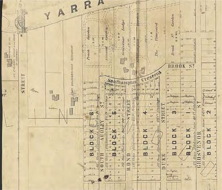
H. Byron Moore’s 1879 map shows much nineteenth-century development
      complete, except for parts of Clifton Hill and Abbotsford.

Collingwood Historical Society                                              6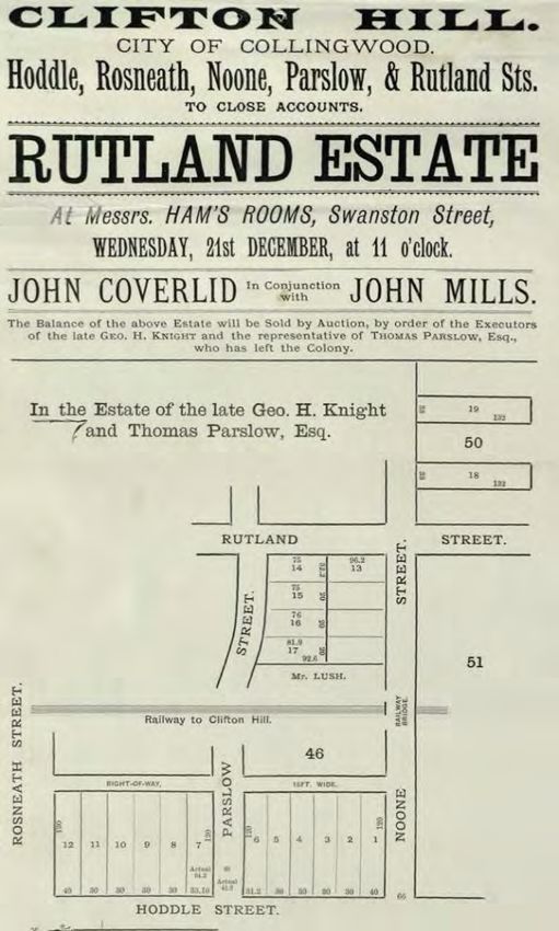
Names
In the early period (and some later periods) subdividers chose the names of the streets and
often commemorated themselves or their relatives, or chose names relating to important
events, personages or places in Great Britain.
Later, it was common for streets to be named after councillors, a practice most recently
carried out in the 1970s (McCutcheon Way). In some cases, street names were changed in
order to provide a memorial for a councillor, or councillors were honoured in the naming of a
park or reserve. Some streets derived their names from the large riverside estates which were
gradually broken up.
Nowadays, naming or renaming roads, features, or localities follows the City of Yarra Place
Naming Policy which operates under the Local Government Act 1989 and the Geographic
Place Names Act 1998 in accordance with the Naming rules for places in Victoria, statutory
requirements for naming roads, features and localities 2016. Council does not normally
consider naming unless there is a property actually fronting the street to be named. Among
the name forms excluded by the regulations are first names, or the name of a living person.
The detailed policy can be found on this page:
https://www.yarracity.vic.gov.au/about-us/governance/place-naming

On council’s website you can also find:
       Register of Public Roads (including laneways):
       https://www.yarracity.vic.gov.au/services/roads-and-traffic

       The origin of some street names (those included in the street signage project):
        https://www.yarracity.vic.gov.au/services/roads-and-traffic/street-signs-heritage

It is not always easy to find out after whom or what a street was named so in some cases we
have relied on intelligent guesswork, as indicated in the text, and in other cases we simply do
not know. Dating can also be problematic as streets are sometimes shown on plans before
they exist physically, and years before building blocks and houses appear. Any further
information will be gratefully received.

                                                                        1880s councillors
                                                                        immortalised not only
                                                                        on the town hall
                                                                        foundation stone but
                                                                        also in street names
                                                                        (except for W Smith)

Collingwood Historical Society                                                                    7
Abbotsford

Abbotsford
The area along the river was chosen largely by people who wanted to retain a large
landholding in the semi-rural retreat of the 1840s, although it was not long before
industrialists were also making use of the river for water supply and drainage. Landholdings
closer to transport routes such as Victoria, Hoddle and Johnston streets were subdivided
earlier, but gradually the large riverside properties were broken up, the largest being the
1880s development of Dight’s Paddock which extended between Johnston, Hoddle and
Alexandra Parade east and was the site of two 1840s houses, Dight’s Yarra House and JDL
Campbell’s Campbellfield. Other riverside mansions also remained into the twentieth century
with reduced landholdings. The name is derived from Abbotsford House which is believed to
have been named after Sir Walter Scott’s house In Scotland.
ABBOTT GROVE, ABBOTSFORD Originally the westerly end of Abbot Street, which was cut in
two when the railway line was constructed.
ABBOTT STREET Part of the 1878 subdivision of Dight's Paddock, this was named after David
Abbott, the solicitor who negotiated the purchase of Dight’s Paddock from the Dight family on
behalf of Edwin Trenerry in 1878 and organised the subdivision of ‘The Campbellfield Estate’.
The first auction was held in February 1878; council bought ten acres which was to become
Victoria Park, so fresh plans were drawn up for a November auction. Sales continued over the
next year or two until, after Trenerry died in April 1880, an auction was held 15 September
1880 for all remaining blocks, including Yarra House. The complete holding was bought by Mr J
J Kelly. In October and November 1881 he began to auction these individually and auctions

                                                         Mr Kelly’s November 1881 plan

Collingwood Historical Society                                                                 8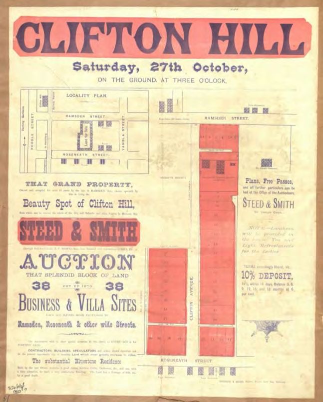
Abbotsford

continued until December 1885. In 1887 there were still many vacant blocks of land in the
Campbellfield Estate and even by 1900 they were not uncommon.
ABBOTSFORD STREET 1852. When John Orr of Abbotsford House began subdividing his
extensive surrounding landholding, it was referred to as the new township of Abbotsford.
This name was eventually adopted for the eastern portion of Collingwood. Sales of vacant
blocks continued into the late 1850s.

ACACIA PLACE A street added when the former Honeywell site at the river end of Victoria
Street was re-developed as Eden on the River around 2013. This is a private road.
ALBERT STREET 1855 or earlier. Possibly named after Queen Victoria's husband Albert, Prince
of Saxe-Coburg and Gotha.
ALLAN STREET See Bloomburg Street
BATH STREET Part of Edwin Trenerry’s 1878 subdivision of Dight’s paddock. Named after
Thomas Bath, an associate of Trenerry’s in Ballarat and who like Trenerry came from the
Parish of St Clement, near Truro in Cornwall. In 1853 Bath commenced business as a
hotelkeeper in Lydiard street, Ballarat, at the premises now known as Craig’s Royal Hotel.
Sales of blocks in the subdivision continued over several years and Bath Street was first built
on in the 1880s.

Collingwood Historical Society                                                                    9
Abbotsford
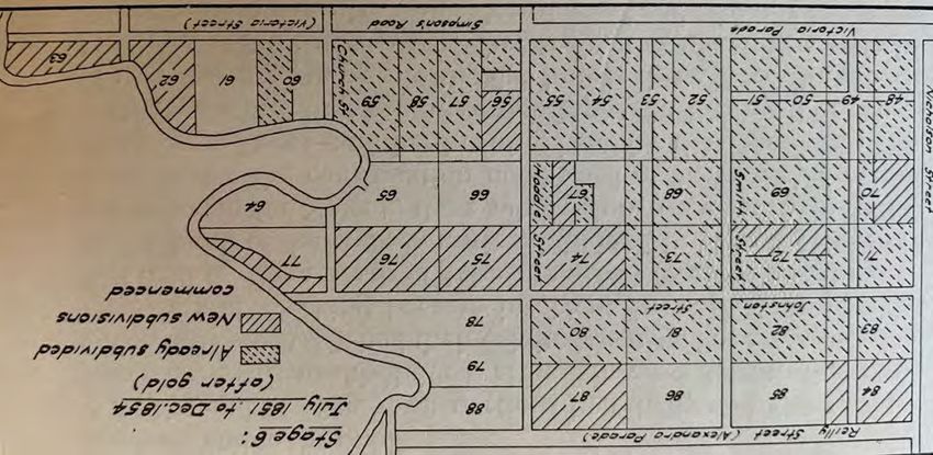
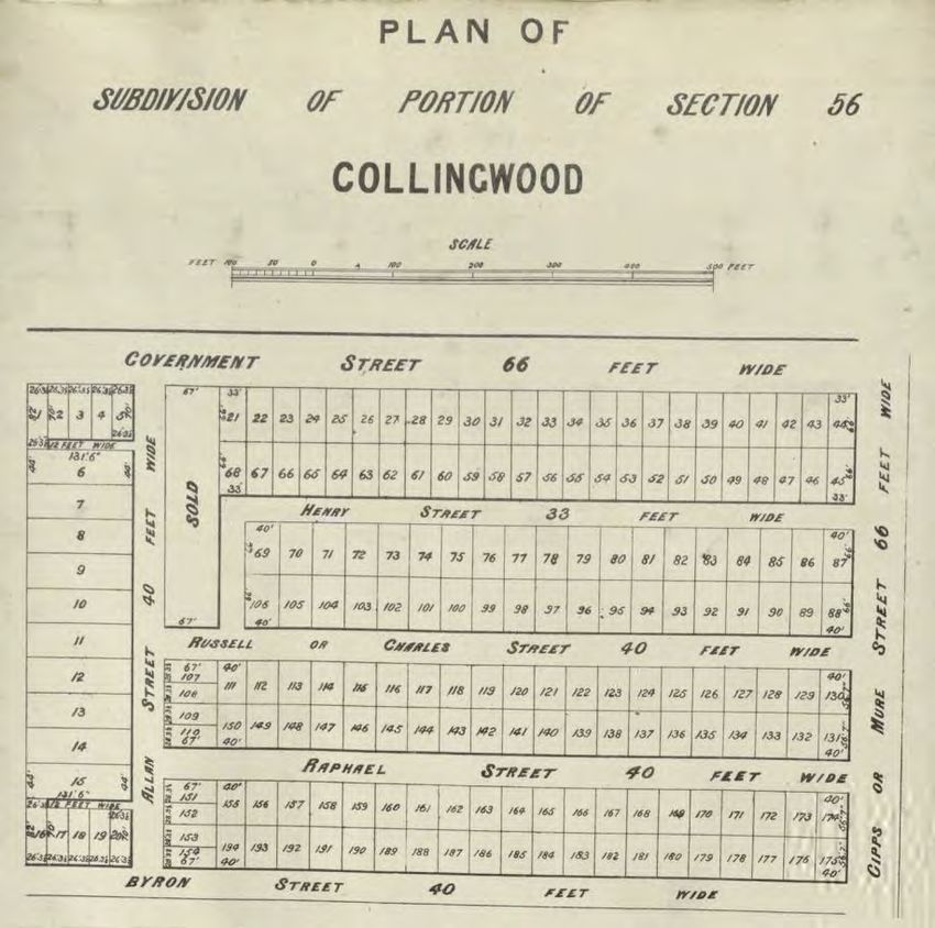
BLOOMBURG STREET Called Allan Street on Hodgkinson's 1858 map and the subdivision map
below, but referred to as Bloomburg in council’s 1857 list of streets.
Plan of subdivision
of portion of Section
56, indicating early
vagaries of
nomenclature
BOND STREET 1858. Several names in this subdivision derive from Mayfair (London) streets.
BRICK LANE See Flockhart Street
BROOK STREET The section of Southampton Crescent between Grosvenor Street and Duke
Street was called Brook Street in the nineteenth century.
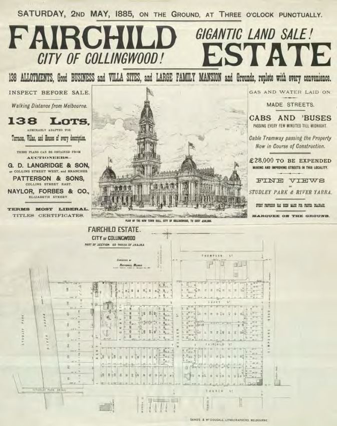
BENT STREET This street is now lost under the massive C.U.B. complex. The area was
previously the riverside site of the mansion and garden of the wool-dealer Jesse Fairchild. In
1885 it was bought up by a syndicate headed by Thomas Bent, M.L.A. and sub-divided into 150
building allotments, although Fairchild’s house was not demolished until the twentieth
century.
BROWN RESERVE A small park in Nicholson Street which has existed since the early twentieth
century.
BYRON STREET See Park Street
CHARLES STREET The section from Victoria Street to Gipps Street is shown on an 1855 map,
but it was not extended through to Vere Street until the late 1880s. Perhaps named after
Collingwood Historical Society 10Abbotsford Charles Nicholson, the early landowner of this area, whose property was first auctioned on 22 April 1851. CHURCH STREET 1850s or earlier, a continuation of Church Street Richmond which dates from the 1840s. A bridge crossing the Yarra to Studley Park was constructed here in 1857 and demolished in 1902. CLARKE STREET On an 1858 map this is called Government Road although by then Clarke was included on the list of streets in East Collingwood. The name probably refers to Captain Andrew Clarke, who in 1853 replaced Robert Hoddle as surveyor-general and was elected M.L.A. He was a prominent Freemason and officiated at the laying of the foundation stone of the nearby Johnston Street Bridge in 1856. CLIFTON STREET the easternmost section of Victoria Street, between Walmer Street and the river, was named as Clifton Street on de Gruchy’s ca 1869 map and Byron Moore’s 1879 map, but was rationalised after the construction of the Victoria Street bridge in the 1880s. COLLINS FOOTBRIDGE This gateway to the Yarra Bend Park that crosses the Yarra at the end of Gipps Street was probably named in honour of A. Collins, the mayor of Collingwood in 1912– 13 around the time the bridge was built. COOK STREET Part of the 1885 subdivision of Jesse Fairchild’s property, it commemorates the maiden surname of Jesse Fairchild’s mother. DIGHTS FALLS Off Trenerry Crescent, this tranquil area of natural beauty includes some remains of John Dight's flour mill which was powered by the falls. DUKE STREET A street in an 1858 subdivision, its name is assumed to refer to the London street. EDDY COURT Randolph ‘Dolph’ Eddy was a Collingwood councillor in the 1960s and 1970s and also became a state parliamentarian. Collingwood Historical Society 11
Abbotsford

FAIRCHILD STREET Jesse Fairchild, a wool merchant, owned a mansion and large garden in the
area now dominated by Carlton & United Breweries. This street was created when the
                                                           property was subdivided into 138
                                                           building allotments in the 1880s.
                                                           Fairchild’s house remained in a
                                                           reduced but still substantial
                                                           garden setting fronting the newly
                                                           created Fairchild Street.

                                                            FEDERATION LANE This was an
                                                            unnamed right-of-way for many
                                                            years, until the construction of
                                                            town houses on the site of the
                                                            Victoria Park school necessitated
                                                            naming for the address of the
                                                            residences facing the rear.
                                                            FERGUSON STREET 1855 or
                                                            earlier. Shown, probably in error,
                                                            on Hodgkinson's 1858 map as
                                                            Regent Street, which is the name
                                                            of the street on the Richmond
                                                            side of Victoria Street, directly
                                                            opposite (not to be confused
                                                            with the Regent street which
                                                            became Nicholson Street).

FLOCKHART STREET Robert Flockhart, a tanner, was a councillor from 1861 to 1864. This street
was originally called Brick Lane and was the centre of the numerous brickworks that flourished
in the area from the 1850s to the 1890s. There were also Chinese market gardens on both
sides of the street. Nowadays, at the end of the street in a picturesque space on the banks of
the Yarra, is FLOCKHART RESERVE.
GAHAN RESERVE John Gahan, born in England in 1851, came to Abbotsford in 1856. He was a
very active member of the congregation at St. Philip's Church of England in Hoddle Street,
being secretary of the Sunday School for 16 years. He ran a contracting business in Victoria
Street and was a councillor from 1887 until 1911, serving three terms as Mayor, in 1893-94
and 1902-04. The reserve was named in 1906 or 1907. Among other things Gahan was an
advocate of public baths for Collingwood.
GIPPS STREET, Abbotsford See Collingwood.
GREENWOOD STREET Thomas Greenwood was a councillor from 1856 until 1865 (including a
term as Mayor in 1863-4) and again in 1868-69.
GROSVENOR STREET This was named after one of the early riverside properties Grosvenor
Lodge, part of which was subdivided in 1858 by Eardley Blois Norton, who had been farming
on the property. The auction on January 25th, 1859 also included land in South Audley, Bond

Collingwood Historical Society                                                             12
Abbotsford
and Duke Streets (all streets in close proximity to Grosvenor Street in Mayfair) and
Southampton Crescent, the whole being described as the Grosvenor Estate.
HARPER STREET This street was not created until the late 1920s and was always a location for
industrial and commercial buildings. The part of Abbotsford between Marine Parade, Gipps
Street, Nicholson Street and the
Yarra River remained undeveloped
later than surrounding areas
because the Blind Creek and
associated drainage meandered
through the area to the Yarra. A
sepia wash and ink sketch of 1854
depicts the creek entering the Yarra.
G B Richardson, Creek and Old
Watering Stage, on the Yarra, East
Collingwood, 1854
MMBW Detail Plan 1309 showing
conditions in 1901
HENRY STREET The existing Henry Street dates from prior 1857. Some older maps also name
Yarra Street between Hoddle and Nicholson Street as Henry Street. See also Henry Street
Collingwood.
HODDLE STREET See Collingwood
HUNTER STREET Part of John Orr’s 1852 subdivision called the Township of Abbotsford.
JAMES STREET 1850s, originally called St James Street, perhaps a reference to the street and
district of that name in London.
Collingwood Historical Society 13Abbotsford JOHNSTON STREET See Collingwood KELLY STREET A small street created between Fairchild and Cooke Streets in the area developed in the late 1880s as part the subdivision of the Jesse Fairchild estate (see Fairchild Street) but later covered by the C.U.B. complex. A probable source of the name is Hugh Kelly, a Langridge Street publican who was elected to council in 1881, helped to bring about the extension of Langridge Street through to Gertrude Street in 1882, and features on the Town Hall foundation stone. LANGRIDGE STREET See Collingwood LITHGOW STREET Part of an area subdivided in 1851. It possibly refers to William Lithgow who was Auditor-General for New South Wales from 1824 to 30 April 1852. LITTLE CHARLES STREET While having the appearance of a lane, especially the section between Langridge St and Victoria St, this was quite a populous street in the 1880s although only a few of the old houses remain. A number of units have been constructed here towards the end of the twentieth century and in the twenty-first century. LITTLE NICHOLSON STREET Half a dozen people were listed in the Sands and McDougall Directory as living in this right of way in the 1890s, while the council rate books referred to them as either ‘off’ William Street, ‘off’ Nicholson Street, or ‘off’ Mollison Street. Such houses were often built in the back yard of another house. One of those old houses remains, facing Little Nicholson Street, but accessed by a gate and path next to 23, its address now 23A William Street. More recently a new house has been built with the address 14 Little Nicholson Street. LIVERPOOL STREET 1858 or earlier, presumably named after the city in England. The short street which ran from Gipps Street to Vere Street disappeared in 1900 to make way for the railway line extension. LULIE STREET Part of Edwin Trenerry’s subdivision of Dight’s Paddock. Trenerry had just married Louisa Rich; Lulie was a diminutive form of Louisa. MARINE PARADE Part of John Orr’s 1852 subdivision (see Abbotsford Street) of ‘The new township of Abbotsford’. This was one of the broader streets in the subdivision, but its name is rather puzzling given its distance from the sea. Lots for sale were referred to as ‘fronting the Yarra’. MASON’S LANE A narrow lane between 339 and 341 Johnston Street. MAUGIE PLACE, MAUGIE STREET This unusual name in Edwin Trenerry’s 1878 subdivision must have had some relevance for him but the source cannot be established with certainty. A possibility is a William Maughan, who was mining in the Ballarat district at the same time as Trenerry. Marked on Byron Moore's 1879 map, although subdivision into the present-day building blocks had not yet been completed. On J J Kelly’s 1881 auction plan, Maugie Place is an unnamed right of way, but by 1904 further subdivision of the eight lots at the Trenerry Crescent end had taken place. Maugie Place and the houses on the north side of Maugie Street made way for the freeway in the 1970s. MAY STREET This street no longer exists. Along with its neighbour River Terrace, it was prone to flooding in the years when the Yarra was badly flooded, such as 1891 and 1934. After 1934 May Street disappeared and Yarra Falls Ltd took over the land. In the 1990s the bluestone Collingwood Historical Society 14
Abbotsford

edging showing where May Street ran off the south side of Turner Street could still be seen,
but this was removed when the housing development in Turner Street was constructed.
MAYFIELD STREET Mayfield was the home of Georgiana McCrae, the watercolourist and diarist
known for her descriptions of life in Melbourne in the 1840s. The property was on nine acres,
the house itself being located in the area now bounded by Church, Murray, and Mayfield
Streets. Abbotsford was a rural area at the time that she and her husband lived at Mayfield,
and she refers to her nearest neighbours as the Currs and Orrs (who lived in the area later
occupied by the Convent of the Good Shepherd). The house was later owned by Sir Francis
Murphy, Speaker in the House, and was finally demolished in 1962 although subdivision of the
land had taken place some time earlier. Mayfield Street seems to date from the late 1880s.
MOLLISON STREET Part of an 1850s subdivision. Garryowen refers to Mollison as a landowner,
and a William Mollison was elected to the Legislative Council in 1853. If this is the man after
whom the street was named, nearby William Street may also refer to him.
MURRAY STREET On 1855 map.
NELSON STREET 1857 or earlier, but not extensively built on until after the subdivision of Jesse
Fairchild's property in 1885. Prior to this it gave access to the large riverside properties of
Frederick Row and Richard Goldsbrough.
NICHOLSON STREET Charles Nicholson, a Sydney resident, was a pastoralist and large
landowner. His subdivision of the area bounded by Church, Victoria and Gipps Streets was first
advertised in April 1851 and dealings continued until 1870. Blocks were advertised as an
opportunity for recent
immigrants to become
freeholders. The plan at
right is probably the
one prepared for the
auction sale 11 May
1859. Nicholson Street
at first began at
Victoria Street and
finished at Gipps Street
while another street
called Regent Street
ran from Johnston
Street to Vere Street.
Eventually Regent
Street was extended to
Gipps Street, yet again
involving council in
purchasing private properties, although the area between Vere Street and Gipps Street was
largely undeveloped until the mid 1880s due to drainage problems. In November 1884 council
resolved to rename Regent Street Nicholson Street, and the construction of the Town Hall in
1885 to 1887 encouraged more settlement in the area.

Collingwood Historical Society                                                                 15
Abbotsford

PARK STREET 1855 or earlier. Gahan Reserve did not exist then, so it was not the source of the
name. Park Street from Victoria Street to Gipps Street was at first called Byron Street. Note
that the two sections of the street developed separately and are not aligned.
PATERSON STREET 1855 or earlier.
PETERS LANE Once an unnamed back lane between Yarra Street and Studley Street
PRINCES STREET 1855 or
earlier, perhaps part of
Charles Nicholson’s 1851
subdivision. A London street.
RAPHAEL STREET On the
1857 list of East Collingwood
streets.
REGENT STREET A London
street. See Nicholson Street
and Ferguson Street, both of
which previously had the
name Regent.
                                                                           MMBW Detail
RICH STREET This was part of                                               Plan 1229, 1905
Edwin Trenerry’s subdivision
of Dight’s Paddock in 1878;
he had just married Louisa
Rich.
RIVER TERRACE This used to run very close to the river off Turner Street and was prone to
severe flooding. After the major flood of 1934, both River Terrace and May Street
disappeared; Yarra Falls Ltd took over the land and built the still-existing concrete flood wall.
See the notes from the 2019 Collingwood History Walk for more details.

                                                    River Terrace
                                                    and May St 1901

RUSSELL STREET 1850s. Perhaps named after the London street. Residents complained to
Council about the state of its footpath in 1873.

Collingwood Historical Society                                                                  16
Abbotsford SHAMROCK STREET The Shamrock Brewery was located in Victoria Street and this street seems to have been created to provide the brewery site with rear access from Flockhart Street. SIMPSON'S ROAD See Victoria Street SOUTH AUDLEY STREET 1858. Apparently named after a London street in company with several surrounding streets. SOUTHAMPTON CRESCENT Part of the Grosvenor Estate (see plan below, to be auctioned by Symons & Perry), which was subdivided from 1858, and apparently named after the London street. See also Brook Street. ST. HELIER'S STREET One of the early riverside houses built along the Yarra in the 1840s was that of Edward Curr. It was called St. Heliers (or Helier’s) and gave its name to the street at the end of which it was located. (The road reservation continues to the river although the existing street stops well short of it). Curr's house was demolished in 1877. A later house in the street was also called St. Helier's. This was located closer to Clarke Street and was the residence of Sir Arthur Snowden who was elected to the Collingwood Council in 1868. His support for the Collingwood Historical Society 17
Abbotsford

Yarra anti-pollution laws led to violent clashes with other councillors and he remained on
council for only one year but was later Lord Mayor of Melbourne from 1892 to 1895.
ST. JAMES STREET See James Street.
ST. PHILIP'S STREET Dates from the late 1880s. This area was not settled until later than the
surrounding parts of Abbotsford because of drainage problems. The building of the Town Hall
in 1886–7 gave an impetus to the area. Presumably it was named after St. Philip's Church of
England which had been built in Hoddle Street in 1865.
STAFFORD STREET 1852 or earlier. Lots were advertised for sale in November 1852. Possibly
named after the county town of Staffordshire, England.
STANTON STREET Job Stanton was the Mayor of Collingwood in 1884–5 and laid the
foundation stone of the Town Hall in July 1885. The street came into existence between this
time and 1887 when the Town Hall was completed; a number of building blocks were
auctioned in April 1888.
STUDLEY STREET 1852 or earlier. Lots for sale in November 1852. John Hodgson, who owned
land in Collingwood, used the name Studley (from Studley Park in his native Yorkshire) for
several of his properties. There is no evidence that he owned land in this subdivision, but his
property on the Kew side of the river was well-known by this time.
THOMPSON STREET 1857 or earlier.
TRENERRY CRESCENT Edwin Trenerry bought the eighty-six-acre paddock between Alexandra
Parade, Hoddle Street, Johnston Street and the river from the Dight family in 1878 for £21,000
and put it up for auction as 262 building allotments. See Abbot Street for more details.
TRURO STREET Part of Edwin Trenerry’s 1878 subdivision of Dight’s Paddock, this was named
after the Cornish town of Truro, near the place where Edwin had grown up.
TURNER STREET James Hobson Turner was a city wool broker who had a house and several
allotments in Collingwood. He was elected to Council in February 1867 and was a councillor
for a total of fifteen years, including terms as mayor in 1869–70 and 1877--78. In the 1860s he
took over a woolwashing establishment near Church Street. He agitated for the repeal of the
Yarra anti-pollution legislation along with other owners of noxious industries along the Yarra.
Residents who complained to Council about the smell of his tannery got nowhere and nor did
the Central Board of Health. In 1874 he joined a partner and established the Denton Hat Mill
in Nicholson Street (still standing, but much enlarged, on the corner of Mollison Street)
conveniently close to his tannery. It was claimed to be the first steam-powered hat factory in
Australia. Turner Street was part of the Dight's Paddock subdivision and the only street not
named after a personal contact of Edwin Trenerry.
VALIANT STREET Part of John Orr’s 1852 subdivision of ‘The Township of Abbotsford’.
VARIAN STREET See Yarra Street.
VERE STREET See Collingwood.
VICTORIA CRESCENT 1855 or earlier. It could have been named in honour of Queen Victoria,
who ruled England from 1837 to 1901, or the state of Victoria (which had been named to
honour the Queen)

Collingwood Historical Society                                                                18
Abbotsford

VICTORIA PARK An area of about ten acres, this land was acquired by the City of Collingwood
from Edwin Trenerry in the late 1870s. It was soon eagerly sought by local sporting teams and
eventually became the home of the Mighty Magpies (Collingwood Football Club) for many
years. More recently the fences have been removed and artworks, sculptures and
photographs dotted about the ground provide entertaining and informative insights into its
history, and despite the departure of the AFL team, the Collingwood AFLW and VFL teams play
the majority of their home games at the venue.
VICTORIA STREET This was originally called Simpson's Road after Mr James Simpson, a
magistrate who constructed a footpath and road in 1843 to serve his own and some
neighbouring properties. The Simpsons are described by Georgiana McCrae as living at The
Grange, the property later known as Yarra Grange, which originally extended to Victoria
Street, the section from Southampton Crescent being sold off in the late 1850s. Although it
was named Victoria Street in the 1850s it continued to be also known as Simpson's Road until
well into the twentieth century.
WALMER STREET 1857 or earlier. A punt once ferried passengers between Abbotsford and
Kew at this spot. The footbridge which still exists was first constructed in 1890-91, with the
primary purpose of transporting fresh water from Dights Falls to the Botanic Gardens. The
source of the name has not been confirmed, but could be connected to Walmer, Kent, where
Wellington as Lord Warden resided in Walmer Castle. (This is the origin of the name of the
Victorian gold mining town, Walmer, near Maldon). As the section of road on the Abbotsford
side is very short, it seems probable that the name originated on the Kew/Studley Park section
of the street, and it could have been connected to Walmer House, residence of Mr Joseph
Lush.
WILLIAM STREET 1855 or earlier. Part of Charles Nicholson’s land, it was possibly named after
his uncle William who brought him up.
YARRA STREET A reference to the nearby river. The wider section between Nicholson Street
and Clarke Street was originally called Varian Street which was created in 1852 and was
changed to Yarra Street around 1900, to become a continuance of the section of Yarra Street
between Hoddle Street and Nicholson Street which had existed from 1857 or earlier.
YARRA BANK COURT A late twentieth century development overlooking the river.
YARRA FALLS LANE A non-existing street name! A right of way serves residential development
on the site of the former Yarra Falls spinning mill, and this name was informally assigned by
the landowners at the time of development in the early twenty-first century, but never
formally named. Confusingly, the name appears on Google Maps.
ZETLAND STREET 1857 or earlier. Could this be Abbotsford’s shortest street? It runs off
Victoria Crescent opposite Mollison Street. This area was mainly occupied by woolwashing and
fellmongering works making use of the river but Zetland Street once gave access to a house as
well, occupied by wool merchants Elliott and William Murray, and angled so the front veranda
faced the river. Nowadays the street functions as a driveway to the neighbouring factories,
which once manufactured products but are now fashion factory outlets. Zetland is an archaic
spelling of Shetland.

Collingwood Historical Society                                                             19
Clifton Hill
Clifton Hill
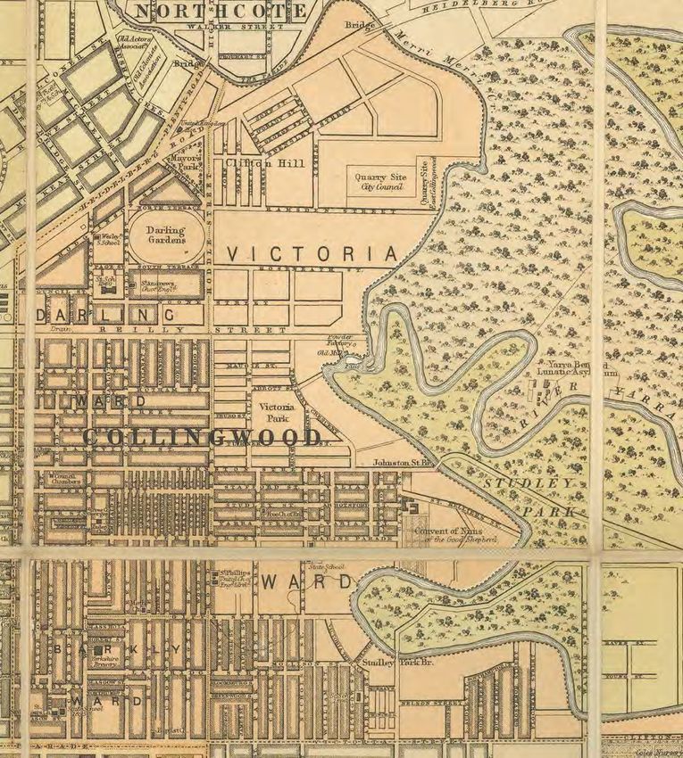
Clifton Hill was not included in the 1838-1839 government auctions described above. When
the municipality of East Collingwood was proclaimed on 24 April 1855, it extended as far north
as Reilly Street (now Alexandra Parade), but within a few months the East Collingwood Local
Committee petitioned for East Collingwood to annexe the area to the north which was
eventually to be named Clifton Hill but was at first referred to as north Collingwood.
Proclaimed in September 1855, the additional area was mostly Crown land but there was
already a bluestone quarry near the Merri creek and three bluestone houses occupied by
Samuel Ramsden and the Brown brothers, who unsuccessfully opposed the annexation to East
Collingwood. Why did the municipality want this additional area? There were three reasons:
to extend Collingwood’s north-south streets (Smith, Wellington and Hoddle) northward to tap
the traffic and trade from areas such as Heidelberg, to gain access to the quarrying area for
street-making materials, and to acquire Crown land space for erecting public buildings.
The eastern and western sections of Clifton Hill showed different patterns of development. In
1864 the Crown land west of Hoddle Street was surveyed by surveyor Clement Hodgkinson
and plans were drawn up showing most of the streets now in existence subdivided into large
blocks for sale. Over the ensuing years the land purchasers subdivided these purchases into
building blocks, but the area remained fairly sparsely inhabited until the 1880s building boom.
Earlier buildings included the Gold Street State School, which opened in April 1874, the first
Wesleyan Methodist church on the corner of Wellington and Hodgkinson Streets (1874), St
Andrew’s church in Gold Street, 1871 (since demolished) and William Fox’s house on the
corner of Hodgkinson and Gold Streets.
Department of Lands and
Survey, 1864
Collingwood Historical Society 20Clifton Hill On the eastern side the early settlers retained large landholdings, the quarries expanded, and noxious industries developed along Reilly Street (now Alexandra Parade east). A land sale in 1871 was the origin of the suburb’s eventual name. Knipe and George’s Property Exchange advertised in The Argus an auction to be held 18 Sep 1871 of allotments ‘in future [to] be known as Clifton Hill’. The origin of the name seems to be mired in speculation. According to Saxton, proprietor of a local newspaper The Tribune, John Hanlon Knipe chose the name as a reference to Clifton in England, but there are at least a dozen such place-names, none of which seem relevant to Knipe’s origins, and Saxton provides no evidence. Another theory refers to a Clifton Farm as an early property in the district, but without any indication of its location. We do know that Clifton Grange, a handsome villa on about five acres, was located in Studley Park with a Yarra River frontage in the 1860s. The addition of ‘Hill’ to the name is easy – in the days of miasma theory, an elevated location was seen as more salubrious as well as providing good views. In November 1872 Knipe held another auction of the remaining lots and the subdivision plan from this date has survived, so we know that it included Berry, Spensley, O’Grady, Fenwick, Grant and John Streets, with Rose, George and Lilly Streets as rear laneways. By this stage one villa had been built (on the corner of O’Grady and Berry Streets) and this was included in the auction. (See the next page for the plan). This area was promoted as being not distant from the city, whereas areas of Clifton Hill further to the east had to wait some years before subdivision. But even Knipe’s area was not extensively built on until later in the 1870s and 1880s. Later subdivisions in the twentieth century include Ford Street, Brockenshire Street, Marshall Place and the development along Field Street, while in the twenty-first century new residential areas have been created in Park Place and the former Synthetics Dyeworks factory site off Noone Street. Collingwood Historical Society 21
Clifton Hill

Collingwood Historical Society            22
Clifton Hill

ABBOTT GROVE, CLIFTON HILL Dates from the mid 1880s. Probably named after Councillor
Abbott.
A’BECKETT STREET The section of Noone Street from Hoddle Street to the Merri Creek was
called a'Beckett Street on an early map and existed by 1857. Thomas a'Beckett, a solicitor who
lived in Victoria Parade, was appointed council auditor in April 1856 and later in the same year
was elected to Council and held the office of Mayor from 1856 to 1859.
AITKEN STREET Named in the late 1880s after Archibald Aitken, a councillor from 1881 to 1887
and Mayor in 1887, and named on the Town Hall foundation stone. He was the son of Thomas
Aitken, who established the Victoria Brewery in 1854, began operating a distillery in
Northumberland Street in 1862 and owned the freehold of several hotels. Aitken senior had
also been a Councillor.
ALEXANDER STREET, CLIFTON HILL A later continuation of the street in Collingwood which had
been named after one of the 1850s goldfields.
ANDERSON STREET Dates from the 1880s.
BARRIES PLACE One of three streets created in the residential development constructed on
the site of the former Synthetic Dyeworks Industries Pty Ltd in Noone Street. Several names
used in this development are non-conforming, because the current Guidelines do not support
the use of first names. In 1958 Barrie Knight started the dyehouse which had previously
housed a tannery.
BERRY STREET This may have been named after Graham Berry, who owned the Collingwood
Observer in the early 1860s and represented Collingwood in the Legislative Assembly. It was
one of the streets where lots were auctioned by John Hanlon Knipe in September 1871 and
November 1872.

BROCKENSHIRE STREET This was a late subdivision in Clifton Hill, carried out by Edward
Brockenshire, who lived at 107-109 Ramsden Street from around 1912 until his death in 1943
aged 78, and was a watchmaker and jeweller by trade. The street is lined with houses built at
the same period and thus showing consistency in building style. The subdivision occurred in
1925–26. The Collingwood Council called for tenders for the construction of Brockenshire
Street on 16 December 1925. In 1926 houses were being built and by 1928 eight houses had
been constructed on the east side and six houses on the west side. 1A is a later addition,
possibly on land excised from Mr Brockenshire’s former house.

BROOKLYN TERRACE In recognition of a house formerly located at 1 Spensley Street named
Brooklyn, this previously unnamed right of way behind 5 Spensley Street Clifton Hill and which
runs between John Street and Grant Street, now provides vehicle access to the unit
development that spans the block from John to Grant Streets. It was named in 2017.

Collingwood Historical Society                                                                23
Clifton Hill

CAROLINE STREET 1882 or earlier. Shown on plan of Waxman’s Estate.

CLIFFORD PLACE Added during a late twentieth century housing development in Ramsden,
Roseneath and Field Street.

Collingwood Historical Society                                                         24
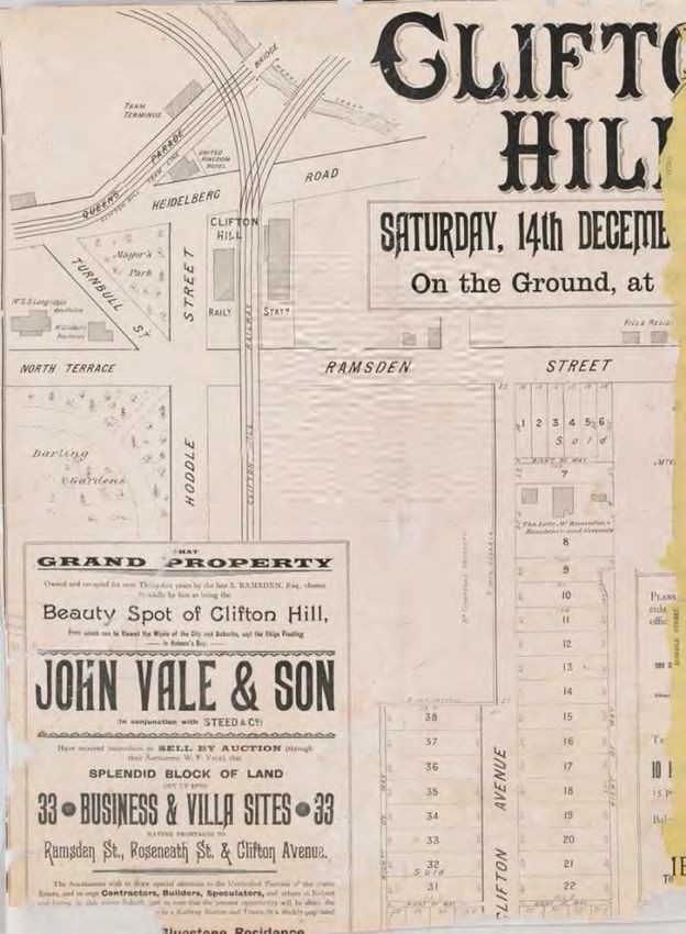
Clifton Hill

CLIFTON AVENUE Samuel Ramsden had an extensive landholding between Ramsden Street
and Roseneath Street; Clifton Avenue was created when the site was subdivided in 1888. It
was first auctioned in October 1888 when Ramsden’s house and a few blocks of land sold;
John Vale & Son auctioned the remaining sites in December 1889.

CLIFTON STREET 1870s, referring to the name of the suburb.
COPPER LANE The lane that runs beside the shot tower.
COULSON RESERVE This sports ground in Heidelberg Road was named in honour of E. Coulson,
Mayor in 1907-08.
COUNCIL STREET Dating from the 1870s.
DALLY STREET The eastern portion of Dally Street is much earlier than the western end, which
was not extended through to Clifton Avenue until many years after the 1888 subdivision of
Samuel Ramsden’s land. Thomas William Dally was a timber merchant in partnership with
Thomas Luxford in Hoddle Street Abbotsford, and the two men owned land around Roseneath
and Dally Streets which they auctioned in late 1889.

Collingwood Historical Society                                                              25
Clifton Hill

DARLING GARDENS This area was temporarily reserved as a site for public gardens in 1863 and
proclaimed as such in 1878. Sir Charles Henry Darling was Governor of Victoria from 1863 to
1868. The gardens remain a place of leafy delight for local inhabitants and have been
celebrated in the book ‘I should be glad if a few more elms and oaks were included’.
DUFFY STREET See O'Grady Street.
DUMMETT CRESCENT Harry Francis Dummett was a councillor throughout the 1950s and
1960s and mayor in 1956. This street was re-named when the overpass was constructed;
before that it was simply part of Heidelberg Road.
DWYER STREET Dates from 1883. Named after Michael Dwyer, a justice of the peace and
mayor from 1882 to 1884. A grocer and produce dealer, he served on council for eleven years.
EDMUND STREET Late 1880s.
THE ESPLANADE 1882 or earlier. See plan of Waxman’s Estate at Caroline Street.
FENWICK STREET Early 1880s. Possibly connected to Orlando Fenwick, Mayor of Melbourne in
the 1870s, after whom Fenwick Street Carlton is named, and who owned land in Collingwood.
FIELD/FEILD STREET 1880s. William Guard Feild was Collingwood's first Australian-born mayor
in 1881–82, having first been elected to Council in 1879. The poor man was doomed to having
the street named after him mis-spelt within a few years, but his name is correctly spelt on the
Town Hall foundation stone.
FORD STREET Constructed in the 1920s when land subdivision took place, and named after
owner, William Ford. The address of his house, now number 2, was originally Ramsden Street
though the house was oriented with a view down the hill to the south.
GEORGE STREET 1871, designed as a rear right-of-way.
GORDON STREET 1890 approximately. Possibly named after Major-General Charles Gordon
who had died at Khartoum in 1885.
GRANT STREET Mid 1870s.
GRAY STREET W. Gray was Mayor in 1885–56 and is honoured on the Town Hall foundation
stone.
GROOM STREET Henry Groom of the Clifton Hill quarries was a big supplier of stone to the
council and in common with a number of early Clifton Hill residents opposed the area's
annexation to Collingwood in the 1850s. He unsuccessfully sought election to council in 1860
but was a Fitzroy councillor from 1858 to 1862.
HALL STREET Robert Hall was a woolwasher who set up in Reilly Street in 1871, having arrived
from England in 1863. Despite protests from residents his business discharged its wastes into
the Reilly Street open drain. It became one of the most productive woolwashing works in
Victoria and he was able to sell out for a big price in 1888. He was on council from 1890 to
1893. HALL RESERVE is on the Merri Creek side of The Esplanade.
HARRYS LANE A right of way within the early twenty-first century development of the former
Dyeworks on the corner of Gray and Noone Streets. Harry and Grace lived on the southwest
corner of Gray and Noone streets; ‘Harry’ (Paul Henry Bradley) had been a chimney sweep at
the old Tannery and became the first employee at the dyeworks which was established on the

Collingwood Historical Society                                                               26
Clifton Hill

site in 1958. A nonconforming street name according to current policy as first names are not
supposed to be used.
HEIDELBERG ROAD The road to Heidelberg. See Queens Parade
HILTON STREET 1870s.
HILTON LANE
HODDLE STREET See Collingwood
HODGKINSON STREET Clement Hodgkinson was a surveyor in the Victorian Surveyor-General's
office who prepared survey plans of Collingwood in 1853, 1856 and 1858, showing the
progress of building development. He was appointed honorary consulting engineer to
Collingwood Council in the 1850s. It is possible that he had some influence on the design of
the Darling Gardens.
HORNE STREET Included on the 1905 MMBW Detail Plan but at that time the 1850s houses
there still used Ramsden Street as their address. Other houses date from after 1911.
JOHN STREET A street in Knipe’s 1871 subdivision.
KENT STREET 1870s.
KIEWA STREET 1884 or earlier. Probably named after Kiewa, a settlement in northwest
Victoria.

                                                        KILGOUR CRESCENT The short section
                                                        of Hoddle Street between Heidelberg
                                                        Road and Queen's Parade used to be
                                                        called Kilgour Crescent, as shown in
                                                        Morgan’s 1920 Street Directory. An
                                                        Alexander Kilgour lived here in the
                                                        1880s. The street layout in this area
                                                        was changed with the construction of
                                                        the 1950s railway line overpass.

                                                        KNOTT'S RESERVE George Knott was
                                                        a councillor in the 1960s and 1970s,
                                                        including a term as Mayor. Knott
competed in the London Olympic Games in 1948 (the 10,000-metre walking race) and had a
long association with the Collingwood Harriers. He was also publican of the Yorkshire Stingo
for many years.
LILLY STREET Shown on Knipe’s 1872 subdivision plan.
LITTLE EDMUND STREET Connects Edmund Street and Clifton Street.
LITTLE WALKER LANE Originally a right of way, this now houses a number of residents
LOUISE STREET Added during a late twentieth century housing development in Ramsden,
Roseneath and Field Street.

Collingwood Historical Society                                                              27
Clifton Hill MARSHALL PLACE Three generations of the Marshall family were Collingwood councillors in the twentieth century. Walter Marshall was on council for 20 years, including a term as mayor in 1919–20; his son Laurie was mayor in 1936–37. Grandson Ttage (Nottage) was a councillor from the 1950s, serving the first of two terms as mayor in 1961 and finally retiring in 1980. The Marshall family also established a number of butcher shops in Clifton Hill and beyond. This street was developed on land which was the site of Sidchrome Industries from 1934 to 1959. MAYOR'S PARK This park was included on the 1864 plan prepared by the Department of Lands and Survey. In 1870 the council minute book includes a petition from the inhabitants of North Fitzroy complaining of the depositing of night soil in the park. MYRTLE STREET 1890 NOONE STREET John Noone was a lithographer in the Lands Department and served on council from 1860 to 1866 including two terms as mayor in 1861–2 and 1865–6. Noone lithographed a plan of west Clifton Hill in April 1864 showing Mayor's Park, Heidelberg Road, Council, Hodgkinson, Wellington, Gold, Page and Noone Streets and North and South Terrace. It was some years before many of these sites were settled. NORTH TERRACE The poor condition of this street and its footpaths (located on the north side of the Darling Gardens) was mentioned in the council minute book on June 1st, 1870. O'GRADY STREET The more westerly section between Berry and Fenwick Streets dates from Knipe’s 1871 subdivision. The western and narrower section was first known as Duffy Street and dates from around 1876. PAGE STREET James Page became the publican of the Galloway Arms Hotel in Johnston Street after starting out as a plumber. He was a councillor from 1863 until 1867, and again from 1870 until 1873. At the age of 84 he published his reminiscences in The Observer (the Collingwood and Fitzroy local paper) on 17 June 1909. Noone's 1864 map of west Clifton Hill shows Page Street. A number of building blocks owned by J Brown were auctioned in 1883. PARK DRIVE A new subdivision in Clifton Hill dating from around 2000, its name referencing the surrounding parklands. Collingwood Historical Society 28
Clifton Hill

                                                    PARSLOW STREET Thomas Parslow owned
                                                    land in the area bounded by Noone,
                                                    Rutland, Hoddle and Roseneath Street,
                                                    which was auctioned on 26 May 1883,
                                                    described by the auctioneer as the Rutland
                                                    Estate. This small street gave access to the
                                                    building blocks of the subdivision and
                                                    Parslow an opportunity for immortality.
                                                    The balance was auctioned on 21
                                                    December 1887.
                                                    By October 1887 five houses in Parslow
                                                    Street had been completed and another
                                                    three were about to be built, but water had
                                                    not been laid on; Council wrote to the
                                                    Water Supply Department asking for a
                                                    main to be laid in the street.

                                                    PECKVILLE STREET 1870s.

QUARRIES PARK This extensive park bordering Yambla Street and Ramsden Street was
developed in the late twentieth century on land where bluestone had been quarried from the
nineteenth century, and part of which was later used as the municipal tip.
QUEEN'S PARADE Originally known as Heidelberg Road, this road which started as the route
from Melbourne to Heidelberg is one of Melbourne’s oldest roads. It was later surveyed by
Robert Hoddle and the wide road we see today was established at two chains in width (a little
over 40 metres). Further along it divided and a separate road diverged northward. Called
Plenty Road, it went to Northcote and the Plenty River area. In honour of Queen Victoria’s
golden jubilee, on 7 June 1887 the name change to Queens Parade was gazetted for the
section of Heidelberg Road and Plenty Road from Northcote Bridge to Brunswick Street. On 10
August in the same year the Clifton Hill cable tram line from the city opened. Find out more
here: Queens Parade History Walk
RAlN'S RESERVE William Rain was born in 1855 and lived in Collingwood from 1859 until 1916.
An architect, he designed additions to Dr. Singleton's clinic in Wellington Street in 1890, and a
number of local factories. From 1901 until 1916 he was a councillor and served one term as
mayor in 1904–5. On 7 October 1907 Councillor Coulson moved that the small park at the
intersection of Heidelberg Road and Queen's Parade be named in honour of Rain.

Collingwood Historical Society                                                                  29
Clifton Hill RAMSDEN STREET Samuel Ramsden worked the Clifton Hill Quarries and Ramsden Street started out as an access road to the quarries as well as the location of his bluestone house and those of his partners, which remain as the oldest houses in Clifton Hill. In April 1856 Ramsden, Henry Groom, and Henry and Charles Brown offered Council £200 if they would form and metal the then unnamed road. Within a year it was named; Ramsden was elected to council in 1857 and served for two years. RAMSDEN RESERVE, a sports oval, was developed in the twentieth century. REEVES STREET Isaac Godfrey Reeves operated a wool washing establishment on the Yarra near Church Street and was elected to council in 1861, and was chairman in 1862. Later he was elected as a member of the Legislative Assembly for Collingwood and campaigned vigorously against the Yarra anti-pollution laws because of the threat they posed to the expansion of business in the Collingwood-Richmond area. He later suffered business failures and died in 1886. The street appears to have not been created until the early 1880s. REILLYS WAY Part of a subdivision off Noone Street on the site of Synthetics Dyeworks Pty Ltd, a reference to the earlier name of Alexandra Parade. ROSE STREET This was an anomaly in that it was named as a street but served as a back lane providing rear access to properties in neighbouring streets. In recent years, however, two structures at the rear of properties have been developed as residences. It appears to be one of the streets referred to by John Knipe in his 1871 advertisements as providing two street frontages for his building blocks. ROSENEATH STREET 1855 or earlier. Possibly refers to Rosneath, Argyll and Bute, Scotland. RUTLAND STREET 1881 or earlier. See also Parslow Street. SMITH STREET See Collingwood. SOUTH TERRACE Indicated on the 1864 Department of Lands and Survey map, on the south side of the Darling Gardens. SPENSLEY STREET This was at first written as Spenceley and the western part of it dates from at least Knipe’s 1871 auction sale. There were two men who might have had some connection with the naming of the street: James Spensley had an ironmongery on the corner of Brunswick and Moor Streets, Fitzroy from 1859 until 1871 and lived in Hoddle Street Collingwood from 1868 until 1871. Alternatively, a Howard Spenceley who arrived in Melbourne in 1858 lived in Gore Street Fitzroy in the 1860s before returning to England in 1872. STAN STREET In 1959 Stan Fayman joined Barrie Knight as his business partner at Synthetics Dyeworks Pty Ltd. TURNBULL STREET Henry Turnbull, a Scottish-born bootmaker, arrived in Sydney in 1838 where he became a noted participant in the anti-transportation agitation. He lived in Wellington Street, was active in the East Collingwood Local Committee from 1853-55, working for the establishment of local government, and was a councillor for most of the 1860s. WALKER STREET Dates from at least 1885. Henry Walker was born in England in 1821 and arrived in Melbourne in 1855. In 1863 he became the owner of a soap and candle factory in Victoria Street on the Yarra where the Honeywell factory was later built (now Eden on the River). His business expanded and gave rise to many complaints from nearby residents including those in Kew about the ‘unbearable odours’. In 1872 he was elected to Council and served altogether for twelve years, including five terms as mayor. Collingwood Historical Society 30
Clifton Hill

WELLINGTON STREET See Collingwood.
WILLIAM STREET Added during a new housing development in Ramsden, Roseneath and Field
Street in the late twentieth century.
WRIGHT STREET 1885 or earlier. Andrew Wright was a councillor from 1874 until the 1880s. A
property owner, he was described in The Observer as ‘a rigid old Tory’ who was opposed to
tramways, municipal loans and ‘such-like inventions of democracy’.
YAMBLA STREET 1884 or earlier. Probably named after the settlement of Yambla near Albury
in NSW.
YARRABING LANE Named in March 2007. Yarrabing (which means the white gum) is the tree
used by the Wurundjeri to welcome people to their lands. The Wurundjeri are the traditional
custodians of the cultural heritage of this land.

The Board of Works Detail Plan No. 1224 shows a mixture of dense
settlement and vacant land in Clifton Hill in 1905

Collingwood Historical Society                                                             31
Sources

Collingwood
This area, closer to Melbourne, was densely settled quite early as many subdivisions began in
the 1840s, not long after the original land purchases. Before long the 1850s gold rush gave a
great impetus to the size of the population. Hodgkinson’s 1858 map shows the pattern of
settlement compared to the sparse buildings further from the centre of town.
ALEXANDER STREET, COLLINGWOOD Named after the Mt Alexander goldfield. The
Collingwood section of this street was part of a small early 1850s subdivision with other
streets also referring to goldfields. By the time of Hodgkinson’s 1 January 1858 map some
houses had been built here. Note Gold Street has not at this date been extended to the north
or south.

   Hodgkinson’s
   Jan 1858 map

ALEXANDRA PARADE First called North Government Road, then Reilly Street, it was named
after Francis Reilly, a Melbourne City Councillor, at a meeting of the Melbourne City Council in
May 1851. The Fitzroy section was re-named in honour of Princess Alexandra of Denmark who
married the Prince of Wales, later Edward VII. The Collingwood section continued to be called
Reilly Street or Reilly Parade until 1908. The centre of the parade, now grassed over, was the
site of a malodorous open drain from 1856. The section of the drain between Wellington and
Smith Streets was not covered in until the 1920s.
BALLARAT STREET Early 1850s, named after the Gold Rush town.
BEDFORD STREET 1853 or earlier. Probably named after Bedford Street in London.
BENDIGO STREET Early 1850s, named after the Gold Rush town.
BLANCHE STREET Dates from the late 1860s. Named after a daughter of Charles Mater,
landowner and owner of the Gasometer Hotel. See Mater Street for more details.
BREWERY LANE A newly named (2010s) thoroughfare within the Yorkshire Brewery
development.

Collingwood Historical Society                                                               32
You can also read