Sniperley Park Sustainable Development Masterplan Vision Document - November 2021 - Durham County Council
←
→
Page content transcription
If your browser does not render page correctly, please read the page content below
Sniperley Park
Sustainable Development Masterplan Vision Document

                     November 2021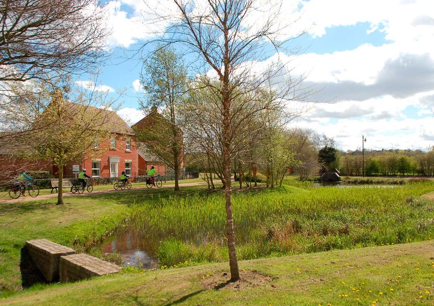
Sniperley Park                                                              Sniperley Park

                                                             Contents

                 1.0    Introduction                                                      4.0     The Masterplan
                       Purpose of the Masterplan                                                The Masterplan Vision
                       Sustainable Development                                                  Framework Plans
                       Consultation
                                                                                          5.0    The Next Steps
                 2.0     Sniperley Today
                                                                                                Phasing
  Blank Page           Strategic Context
                                                                                                Next Steps & Programme
                       Townscape
                       Site Constraints
                       Landscape and Green Infrastructure
                       Access & Movement

                 3.0     The Vision
                       Vision
                       Objevtives
                       Key Moves
                       Guiding Design Principles

                                                            Version:		          8
                                                            Version date:       4th November 2021
                                                            Comment		           Draft Report

                                                            This document has been prepared and checked
                                                            in accordance with ISO 9001:2015

      2                                                                             3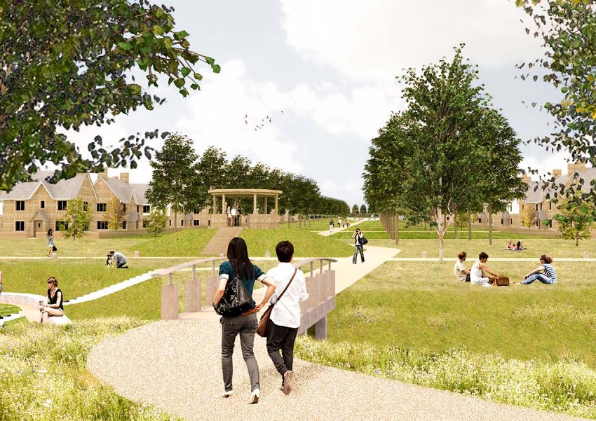
Sniperley Park         Sniperley Park

  Blank Page

                 1.0 Introduction

      4                      5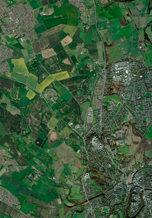
Sniperley Park                                                                                                                             Sniperley Park

                 Purpose of Sniperley Park Sustainable                           school, community building and significant highway                   •   Deliver land for 1700 homes (which meet the
                 Development Masterplan                                          improvements.                                                            requirements for affordable and older persons housing);
                                                                                                                                                      •   Provide a centrally located local centre which will act as
                 The masterplan has been developed by the Council,               The production of a comprehensive masterplan is                          the focus for community activity;
                 including discussions with site promoter and landowners,        intended to enable a ‘joined-up’ approach across multiple            •   Identify a suitable site for a readily accessible primary
                 to create shared vision for the site which will guide the       land holdings to bring forward proposals that have a                     school and the replacement (or retention) of playing
                 future planning, design and development of the site as it       coherent approach to placemaking, access, movement,                      fields;
                 moves towards and beyond delivery.                              green infrastructure and drainage.                                   •   Provide structural landscaping and sustainable urban
                                                                                                                                                          drainage;
                 This masterplan outlines our understanding of the               The principles set out in this document are there to ensure          •   Have appropriate regard for Sniperley Hall and Farm
                 existing site and its context, outlines our vision for the      that new development meets national and local planning                   and retention of the woodlands;
                 development of the site and defines a clear framework for       policy objectives for sustainable development, good                  •   Give special regard to the significance of any visual
                 its delivery. Ultimately, the report aims to set out Durham     design and placemaking as well as meeting regional and                   associations with the World Heritage Site;
                 County Council’s expectations for the site, against which       local housing needs.                                                 •   Provide approximately 25ha linear park within the site;
                 future Planning Applications will be assessed.                                                                                       •   Provide compensatory Green Belt improvements;
                                                                                 The final part of this document sets out anticipated next            •   Grasp opportunities for a district heating system; and,
                 Durham County Council declared a Climate Emergency in           steps; with high level phasing suggested together with               •   Ensure strong connections beyond the A167 via
                 2019. As part of that declaration we are working towards        an outline of the planning approach. It is important to                  suitable, convenient, safe and attractive cycleways and
                 a Carbon Neutral County Durham as soon as possible. The         note that the Masterplan has been prepared using the                     footpaths
                 vision that we are aspiring to is that all the energy that we   evidence base prepared for the County Durham Plan,
                 use will be generated from renewable sources, including         which by the nature of that process is high level. However,          Consultation
  Blank Page     the way we heat our homes, both new and old. All of our         much more detailed assessments relating to transport,
                 transport will be ultra-low carbon, and everyone will have      ecology, noise, visual impact etc. will have to be submitted         How Do I Get Involved?
                 access to safe and reliable public transport. Our natural       by the applicant as part of the planning application                 Consultation on the draft Masterplan begins on 29th
                 environment will be thriving and beautiful and it will easily   process. These will be consulted on as part of process               November 2021 and 14th January 2022. All comments
                 offset any remaining carbon emissions. Our strong local         of determining the planning application. Nevertheless,               should be submitted to us by 4.30pm, 14th January
                 economy will supply locally grown food and many of              the vision and principles set out within this document               2022. Comments can be submitted on our consultation
                 the other goods that we need, creating local jobs. There        should be treated as the starting point for forthcoming              portal: https://consultdurhamcc.objective.co.uk/
                 will be almost zero waste in a circular economy and our         masterplanning work which may form an outline                        kse or sent via email to spatialpolicy@durham.gov.
                 residents and businesses will be protected from extreme         application for the site.                                            uk or by post to the Spatial Policy Team using
                 weather events.                                                                                                                      our freepost address, which is Freepost Spatial Policy.
                                                                                 This document should be read in conjunction with the                 No further information is required for the address.
                 This is in line with the need to significantly reduce           County Durham Plan, which give further background and
                 emissions in this decade and to ensure that new                 detailed analysis of the site and its context.                       On request a Microsoft Word response form is
                 development does not increase the burden of emissions                                                                                also available. You can also telephone the Spatial
                 reductions by constructing homes that have low                                                                                       Policy Team with any questions, to request hard
                 embodied emissions and are heated and powered by                Sustainable Development                                              copies of the documentation or to request further
                 renewable sources.                                                                                                                   information on tel: 03000 261906/261907.
                                                                                 The National Planning Policy Framework (NPPF) is clear
                 The Sniperley development provides an opportunity to            that the purpose of the planning system and resultant                A summary of all representations on the will be published
                 show what can be achieved through good sustainable              development is to contribute to the achievement of                   in a Statement of Consultation, but apart from the name
                 planning, by ensuring there is no connection to the gas         sustainable development and the delivery of good                     of the sender and company/organisation (if relevant) no
                 network, instead heating homes through passivhous               design. The Local Plan (5.281 -282) sets out to raise design         other personal information will be publicly available. The
                 principles, individual Air/Ground Source Heat pumps             standards based upon a thorough understanding of the                 Council will share details in line with the Spatial Policy
                 or district heating; sustainable construction methods;          site and its wider context.                                          Privacy Notice and when required to do so by law and/
                 embedding excellent transport links throughout; and                                                                                  or statutory regulations in producing the development
                 ensuring biodiversity is maximised.                             The site has been subject to an Examination in Public as             plan and planning policy documents. Any information
                                                                                 part of the Local Plan and the Inspector concluded that              and personal data will be retained securely and in line
                 Sniperley Park will also provide opportunities to live well     exceptional circumstances existed for the removal of the             with Durham County Council’s retention guidelines.
                 and nurture physical and mental wellbeing including             site from the Greenbelt, thus highlighting its sensitivity in
                 through extensive and high-quality new parkland                 its location on the edge of the city. Local Plan Policy 5 sets       Following this consultation, officers will review and
                 both within the site and on the remaining Green Belt            out the policy requirements for Sniperley Park itself.               consider all of the comments made and changes made
                 for new and existing residents. The site will also be                                                                                where possible. We will give reasons where it has not
                 supported by the infrastructure it needs to be a thriving       In summary, the policy establishes that the masterplan               been possible to make a change. The revised Masterplan
                 community, including a new local centre, a new primary          must include the following key components:                           will then be published as soon as practicable.

      6                                                                                                                                           7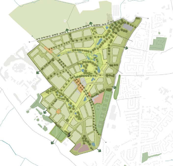
Sniperley Park           Sniperley Park

  Blank Page

                 2.0 Sniperley Today

      8                        9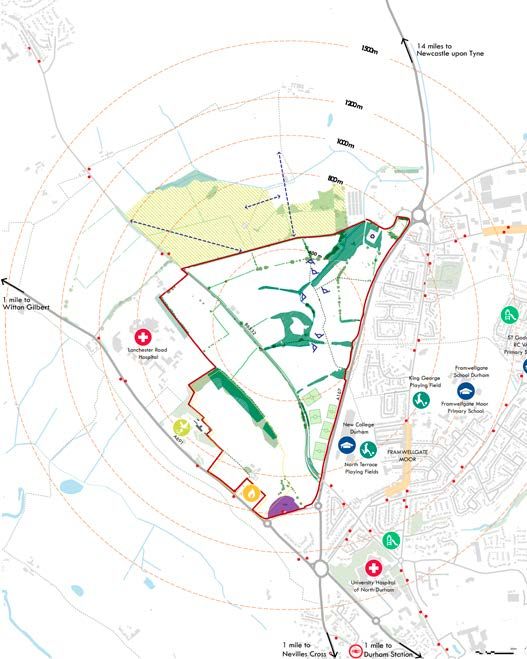
Sniperley Park                                                                                                         Sniperley Park

Strategic Context                                            The suburban communities of Framwellgate Moor and
                                                             Pity Me sit adjacent to the site to the south east, providing
Sniperley Park is located to the north-west of Durham        a number of local amenities within a short walk of the
City; to the west of Framwellgate Moor and Pity Me. The      site including New College Durham (post 16), schools
site is situated between the A167, which runs north out      and local centres. A limited number of small detached
                                                             properties and farms are located to the north of the site                    SACRISTON
of the city towards Chester-le-Street, and the A691, which
runs north-west out of the city towards Lanchester and       between the site boundary and the village of Sacriston.
Consett. Running between these two A-roads, the B6532
dissects the site and connects Durham to the village of      Connections to City Centre
Sacriston to the north.
                                                             Whilst on the edge of Durham, the site is well connected
The site benefits from close proximity to Durham             to the city centre. From the centre of the site it is 2.5
                                                                                                                                                                                           A167
Railway Station, accessible either by foot, bicycle or       miles to the city centre - around a 40 minute walk or a
bus and providing frequent connections regionally to         15 minute cycle on well signed, good quality cycle paths.
Newcastle (12 min.), Darlington (15 min.), York (47 min.)    A bus from the Park & Ride site or local bus stops takes
and, further afield, to London (3 hrs).                      around 20-25 minutes into the city centre.

The Site
                                                                                                                                                                  B6532
The site can be broadly sub-divided into three areas; the
western area around Sniperley Hall, the central Sacriston
                                                                                                                                                                                                  PITY ME
Road corridor and, finally, the north eastern part of the
site around Cater House Pit.
                                                                                                                                                  A691
The western part of the site is defined by a mature
woodland belt, creating a largely self-contained area                                                                                                                         SNIPERLEY
                                                                                                                                                                                PARK
of parkland puncuated by the historic buildings of
Sniperley Hall and Sniperley Farm. The site falls to the
west towards the A691. The more modern structures of
Lanchester Royal Hospital, to the north, and the Durham
                                                                                                                                                                                          FRAMWELLGATE
Community Fire Station and Park & Ride, to the south,                                                                                                             Sniperley                  MOOR
surround the area.                                                                                                                                                  Hall

The central swathe of the site, flanking the B6532,
consists of open terrace farmland with clear vistas
towards Sacriston to the north and includes the existing
sports pitches adjacent to the A167.

The north eastern part of the site is strongly shaped
by the Folly Gill catchment and Cater House Pit - with
associated steep topography and existing woodland. In
the northernmost point of the site is the Potterhouse Lane
Household Waste Recycling Centre, accessed from the
Pity Me roundabout or from Potterhouse Lane itself.

                                                                                                                                                                                                            DURHAM

                                                                                                                                   Sniperley Park Site Boundary                                                      Strategic Context
                                                                                                                       10                                                                                                                     11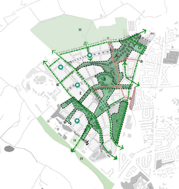
Sniperley Park                                                              Sniperley Park

Townscape                                                                                                                   Area of Interest      Distance from Former
                                                                                                                                                   Cater House Pit

The local ‘villages’ of Framwellgate Moor and Pity
                                                                                                                            Buildings             Water Areas
Me are closely related to the growth of coal mining
in the area. Framwellgate Moor owes its existence
to Framwellgate Colliery (the Old Pit). It’s biggest                                                                        A Roads
                                                                                                                                                  Water Lines
development occurred in the C19th and early
C20th with the growth of the coal mining industry.                                                                          B Roads & Other       TPO Areas
Caterhouse (also called New Pit) was Framwellgates
partner pit and was opened in 1894. The pits were                                                                                                 Ancient Woodland
connected both underground, and over ground by the                                                                          PRoW                   Inventory
wagon way.
                                                                                                                            Fire Station          School/College
The defining feature of both Framwellgate Moor and
Pity Me are the strong frontages onto Front Street - the                                                                    Play Area             Playing Fields
majority of which remain as 2-storey brick terraces.
Along this street are intermittent modern parades of
                                                                                                                            Compensation Area     Local Centre
shops and individual businesses intermingled with
residential properties.
                                                                                                                            On-Site Playing
                                                                                                                             Fields               Existing P&R
Sacriston, approximately 1 mile north of the site, was
also historically closely connected with coal mining.
                                                                                                                            AHLV                  Bus Stop
The village is structured around the crossroads of
Front Street (B6532) and Witton Road/Plawsworth                                                                                                   Sniperley Farm
                                                                                                                            Individual Trees
Road (B6312) both of which have a strong frontage of
terraced buildings. To the north of the B6312 further
terraced streets are set out in a gridded layout More                                                                       Hedgerow              Vista
recent development has extend Sacriston further north
and south and includes a wider mix of detached and
                                                                                                                            Hospital              View Opening
semi-detached dwellings.

Similarly other local settlements, for example Bearpark                                                                     Sniperley Hall&Park
and Brancepeth, have developed over time, originally
a small terrace of houses fronting onto the main street,
and over time expanding to include a wider range of
house types.

There are a number of key external views into and out
of the site, as well as external views. Whilst the site is
reletively concealed there are key strategic views into
the site from the B6532 to the north. Likewise, views
out of the site are to the north with glimpses of the                                                         SITE PHOTOS
Penshaw Monument to the north east. Internal views
are limited to local internal views framed by mature
tree belts, hedgerows and field boundaries. Views to
existing structures of Sniperley Hall and Sniperley
Farm, to the west, are limited from within the site
but are part of the visual character to the west. Views
to the east and south are dominated by highways
infrastructure and the current connections (B6532 and
underpass) are somewhat unwelcoming pedestrian/
cycle connections.

                                                             Surrounding Townscape Setting

                                                                                                  12                                                                          13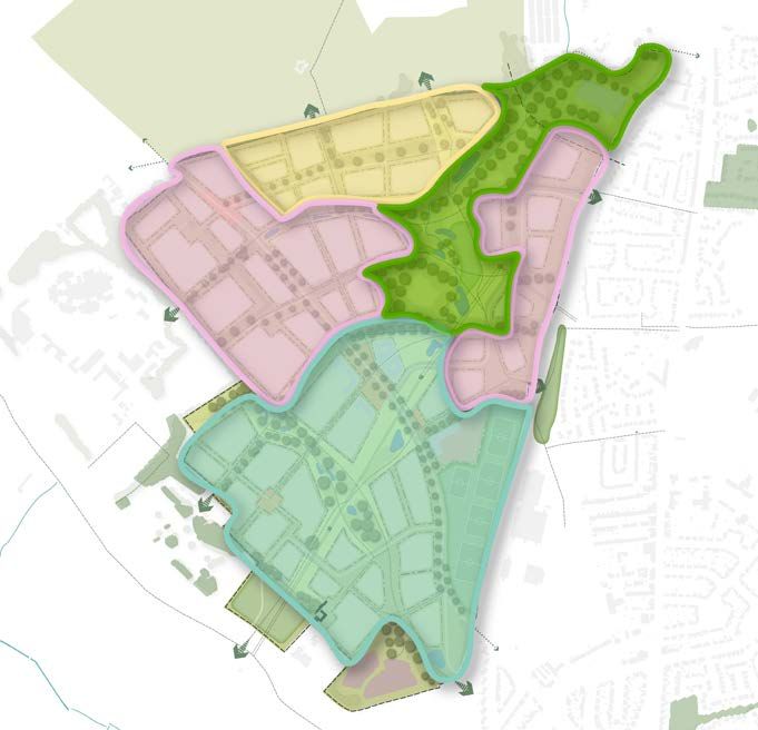
Sniperley Park                                                                        Sniperley Park

Heritage Context                                                                                                                   Area of Interest                                   Historic Growth
Sniperley sits to the north of Durham’s historic centre                                                                                                                               The adjacent plan outlines the historic growth of
                                                                                                                                   Green Belt
and the designated world heritage site. The centre of                                                                                                                                 Durham city and the surrounding area. It shows
Durham also contains a number of listed buildings and                                                                                                                                 how the city grew around the river and Castle before
conservation areas and, whilst all of these sites are not                                                                          Woodland                                           expanding towards the northern Pit Villages, gowing
within close vicinity. they provide significant historic                                                                                                                              out of the river valley. The natural form of the River
value and townscape context.                                                                                                       Green Spaces                                       Wear has created green seperation within the city,
                                                                                                                                                                                      forming wedges to the north east and south in
In the context of Sniperley, the historic value of the                                                                             Primary / A Roads
                                                                                                                                                                                      particular.
landscape, particularly Cater House Pit, and Sniperley
Hall to the west deliver a distinctive character for the                                                                                                                              Growth through the 20th Century expanded the city
                                                                                                                                   B Roads & Other
area. In addition Sniperley Farm and the surrounding                                                                                                                                  to the borders of Sniperley Park with the A167 creating
Pit Villages to the north offer historic towns                                                                                                                                        an edge to the city. Expansion of the city in Sniperley
                                                                                                                                   PRoW                                               Park provides a logical evolution, if done sensitively to
                                                                                                                                                                                      create a distinctive urban edge to the city.
                                                                                                                                   Railway Tracks

                                                                                                                                   Water Bodies

                                                                                                                                   Conservation Area

                                                                                                                                   WHS

                                                                                                Crook Hall                         Buildings

                                                                                                                                   Listed Building
                                                                                                                                     Grade I
                                                                                                                                   Listed Building
                                                                                                                                     Grade II
                                                                                                                                   Listed Building
                                                                                    Durham Castle                                    Grade II*

                                                                                                             Durham Cathedral                          1955-1961
                                                                                University College
                                                                                 Durham University
                                                                                                                                                       1920s-1940s
                                                                                                             St John’s College
                                                                                                               Durham University
                                                                                                                                                       1885-1900

                                                            Heritage Context

                                                                                     14                                                                                   15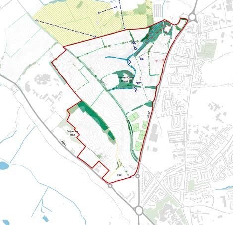
Sniperley Park                                               Sniperley Park

Site Constraints and Considerations                                                                            Area of Interest      Mine Shaft Location

The townscape review sets out the transition from the
                                                                                                               Buildings             Manhole
parkland around Sniperley Hall, through the central farmland
and onto the areas around Cater House Pit and the Folly Gill
                                                                                                               A Roads               Steep Terrain
catchment. The site is also defined by a number of natural and
man made factors which create constraints or challenges to                                                     B Roads & Other       Water Areas
development.
                                                                                                               1m Contour Lines      Water Lines
The key technical constraints and considerations to
development are:
                                                                                                               50m Buffer Line       AHLV

1   Existing pylons & overhead powerlines
                                                                                                               Waste Recycling
                                                                                                                Centre               Existing P&R
2   Vehicular noise and air pollution generated along the
    A167, the A691 and, to a lesser extent, the B6352                                                          Overhead Power Line
                                                                                                                                     60m Buffer (each
                                                                                                                                      side of the road)

                                                                                                                                     Sniperley Farm (to
3   Proximity to Household Waste and Recycling                                                                 Power Line Mast        retain)
    Centre (HWRC) on Potterhouse Lane, including
    the potential for a buffer to any residential                                                              Power Line Safety
                                                                                                                Zone
                                                                                                                                     Sniperley Farm (to
                                                                                                                                      demolish)
    development (c50m) and its required expansion

4   Sensitive response to nearby heritage including
    to Sniperley Hall and Sniperley Farm

5   Existing mine shafts

6   Existing woodland, landscape features
    (inc. Cater House Pit local nature area) and
    steep topgraphy to north east of site

7   Retention of existing Park & Ride site and
    requirement for expansion of this facility

8   Retention of the B6532 running through the centre
    of the site to facilitate north-south connection
    between Sacriston and Durham city centre

9   Congestion on Potterhouse Lane related
    to operation of civic amenity site

10 Sports pitches occupying large area of site

Many of these factors can be considered enabling constraints
which, if treated sensitively and considered creatively through
the masterplan process, could become distinctive assets to
the site. For example, the centrally located constraints and
topography can become a distinctive and accessible landscape
feature for the central linear park for the site.

Further opportunities and constraints relating to landscape
and green infrastructure are set out in the next section.

                                                                  Existing Site Constraints

                                                                                                   16                                                           17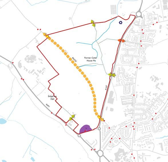
Sniperley Park Sniperley Park
Ecology, Landscape &
Green Infrastructure
features through the site and should be sensitively
addressed by the masterplan.
Landscape Character
A
Based on the existing land form and landscape and
The Masterplan contributes to and enhances the natural • Views into the site from the wider area to the south ecological context we can defined three landscape
environment. It seeks to minimise impacts on, and and east are limited by vegetation and the landform character areas across the site. The plan adjacent outlines
provides net gains for biodiversity while reflecting the • Some elevated longer views over the site from the these defined areas.
special landscape character of the area and ensuring high edge of Sacriston to the north-west and very long
quality green infrastructure throughout the site. The site distance view to Penshaw Monument to north-east A - Sniperley Parkland
benefits from a wide range of landscape features which
provide positive aspects to be included as part of the
development, though they also bring some constraints or
•
•
Limited visibility between the site and
the city centre / World Heritage site
The site is largely enclosed by woodland / landform
• Estate farmland forming part of the historic
parkland setting of Sniperley Hall
C
challenges to how the site might be developed. • Greater visiblity within central corridor either • Medium scale arable fields
side of the B6532 (apart from southern end) • Remnant hedgerow structure with occasional trees
B
Valuable landscape, wildlife & heritage assets: creating a inward looking land form in this area • Enclosure provided by substantial belt of planted
• Visibility across land to the north-east of the site woodland along north east boundary and gently
The following landscape features are vital assets for is limited by landform, woodland and tree cover rising land to ridge along south west edge
Sniperley Park and should form a key element of the
emerging masterplan. B - Open terrace farmland
• Large-scale farmland under arable/
• Folly Gill valley system and woodlands to grassland cultivation
the north east, including steep topograhy &
watercourse – avoid severance by roads
• Regular, orthogonal field pattern
typical of later enclosures
A
• Cater House Pit Nature Reserve and wagonway • Open, expansive character with some
at the centre of the site; steep topography and remnant hedgerows but limited tree cover
woodland - respect heritage and wildlife value • Flattish or gently undulating topography
• Sniperley Park and Browney Valley Area
of High Landscape Value - respect the C - Folly Gill catchment
historic parkland /landscape value
• Hedgerow network, mature trees and
woods, historic network of roads and
paths - keep intact where possible
•
•
More complex topography forming
drainage system of Folly Gill
Smaller-scale, fragmented and irregular pattern of
B
pasture/arable fields, incised wooded valleys and
It is important to note that whilst this masterplan work developing woodand/scrub at former Cater House Pit
has been informed by desktop analysis of ecological • Strong enclosure and intimate character provided by
issues and opportunities for biodiversity net gain. The mature hedgerows, woodland and other tree cover
masterplan is informed by baseline ecological data
comprising of data searches and aerial photography
which identifies the key ecological and green Existing Landscape & Green Infrastructure
infrastructure receptors on the site. These receptors are
then protected and enhanced through the development
of the LPA masterplan and used as the basis for the Area of Interest 1m Contour Line Water Areas Hedgerows C
schematic layout of the site and the green infrastructure
provision. Buildings Steep Terrain Water Lines Vista
Future planning applications will be informed by more A Roads On-Site Playing Fields AHLV View Opening
detailed ecological survey work that includes habitat
assessments and surveys for protected or priority species
B Roads & Other TPO Areas Compensation Area
to ensure that the ecological value of the site will be
protected and enhanced Ancient Woodland
PRoW Inventory Individual Trees
Visual characteristics
The following visual characteristics create distinctive
18 19Sniperley Park Sniperley Park
Access & Movement Strategic Road Network Area of Interest
Access into the site and its character is currently The site is flanked on two edges by A-roads. The A691
Buildings
dominated by highways, being abutted on all edges by (60mph, one footway on eastern side) is set back from site
major arterial routes and dissected by a key north-south boundary to the west with a private access provided to
connection into Durham city centre. There are, however, Sniperley Hall, Lanchester Hospital and the Community A Roads
an extensive network of public rights of way which Fire Station. The A167 (60mph, shared footway/cyclepath
navigate through the site to the north. The masterplan on eastern side) generally sits above the site to the east. B Roads & Other
will maximise the opportunities for sustainable and active The A167, in particular, creates significant noise and air
travel in order to deliver a sustainable, healthy and active pollution along the edge of the site. The only existing
PRoW
new urban community. direct access into the site is provided off the Pity Me
roundabout to the north, however further access is
Walking and Cycling provided via the B6532, via Trouts Lane and the Blackie Water Areas
Boy Roundabout.
The following public rights of way traverse the site.
Local Roads Water Lines
• Bridleway 4 / Footpath 4 /Footpath 10 -
Connection from underpass beneath A167 The B6532 (60mph, one footway on eastern side) dissects Bus Stop
from Framwellgate Moor, heading north across the site, providing direct connections into Durham
City Centre and north to Sacriston. Its intersection with Waste Recycling
the site to Potterhouse Lane and beyond Centre
• Footpath 5 - Connection from the eastern Trouts Lane and Potterhouse Lane creates a staggered
edge of the site from Pity Me, across the A167 junction which links the B6532 with the adjacent A-roads.
Underpass
at grade and connecting to PROW 4 Both lanes are rural in character and have limited
• Bridleway 6/44 - Connection from this path west, carrying capacity.
south of Cater House Pit linking to B6532
Existing P&R
Whilst the site has good provision of public rights of
way to the north it is poorly connected on its edges to High Street
surrounding communities, with the only access across the
A167 provided by a poorly lit and suffering from localised
flooding underpass. The west of the site has no public Pedestrian Access
right of way connecting into or through it. Furthermore,
pedestrian crossings on the A691 are very limited. Vehicular Access
Public Transport Pedestrian Access
(restricted)
Sniperley Park & Ride is situated to the south of the site
with regular (10 mins) connections into Durham City
Centre. Further bus connections are provided off the A691
and the B6532 (jct with Potterhouse Lane) connecting
into and out of Durham.
Whilst provision is good for the site there is limited
connectivity to existing bus stops, and particularly
the P&R, so the masterplan will need to unlock these
connections and ensure provision through the site.
Additionally, there is an existing requirement for
aPark&Ride extension that has to be taken into account Existing Movement & Access
when safeguarding future access onto the site.
20 21Sniperley Park Sniperley Park
Blank Page
3.0 The Vision
22 23Sniperley Park Sniperley Park
Durham County Council’s vision for
Sniperley Park is that of a high quality, County Durham Plan:
Policy 5 requirements
zero carbon well designed community
that will stand the test of time and * The provision of such a integral public park at the heart of the proposals • Sniperley Park will be a sustainable
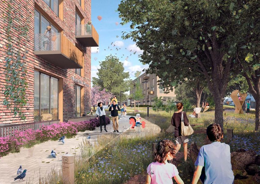
will be a fantastic amenity for residents and the local community urban extension incorporating a
leave a legacy which Durham will be - providing opportunities for healthy lifestyle and recreation. centrally located local centre
proud of. * The park provides an opportunity to retain and incorporate important • A new primary school will be provided
existing landscape features and habitat across the site including of a scale which will meet the expected
woodland, trees and hedges, Folly Gill and Cater House Pit. requirement for school places generated
Folly Gill Park, the linear park, and the compensatory * The park will also be important as a means for crossing through by the new housing development
land to the north and south-west will be a fantastic the scheme - it will accommodate the existing Public Rights • The design of development in the vicinity
asset for those living in this area and across Durham. of Way plus will be a setting within which to provide new of Sniperley Hall and Farm will have
It will define a new urban edge to Durham, sensitively pedestrian and cycling routes to create a well connected place. regard to their character and setting, and
transitioning from urban to rural. Sniperley Park will Creating a Destination * The existing variation in landscape character should the recognition of the area as an Historic
combine the best of city and country living by creating Public Park strongly influence the proposals for the park. Park and Garden of Local Interest
healthy homes and workplaces in a vibrant community • A linear park will be provided in
set in a beautiful landscape setting. perpetuity through the centre of
the site. The park will comprise of
Sniperley Park will have excellent connections by foot and approximately 25 hectares of public
bicycle to the existing neighbourhoods of Framwellgate open space, wildlife habitats, playing
Moor and Pity Me; connecting to these existing fields and community woodlands
communities to their mutual benefit. connected by a network of footpaths and
* There is a great opportunity to create a community which is well cycleways linking housing areas with
The masterplan for Sniperley Park will be landscape- connected; this includes the need for good physical infrastructure the local centre, the wider countryside
led; delivering high quality, large scale open spaces and to provide direct, safe and attractive routes between Sniperley Park and the urban areas to the east
Forged by an industrious and productive landscape, Sniperley Park will take its vital next steps drawing the landscape character from Sniperley Hall,
Cater House Pit and the wider Durham landscape.
and it’s adjacent neighbours - the communities of Framwellgate
Moor and Pity Me, plus to nearby amenities such as the Park &
• In order to achieve sustainable and
cohesive communities, the development
into becoming a sustainable residential community for the future of Durham. The community Objectives & Key Moves *
Ride, local schools, hospitals and the compensatory land.
It is important in creating a sustainable urban extension that
must be connected to the existing
development to the east of the A167
will be shaped and connected to its rich history and beauty in order to deliver a sensitive and the residents are enabled to walk, cycle or take public transport
rather than necessarily being reliant on a private car.
through suitable, convenient, safe and
attractive cycleways and footpaths
landscape-led extension to Durham. Building on the landscapes existing built assets, Sniperley
The masterplan set out within this section is framed by Making Connections • The expansion of the Sniperley Park
the objectives set out in County Durham Plan, Policy 5. and Ride facility will be required.
Hall and Sniperley Farm, it will be a welcoming, yet self-sufficient place which builds on the
This sets out the objectives for Durham City’s Sustainable Attractive and safe links between
Urban Extensions. A summary of the key aspects of this the housing and the existing Park
assets of the local area, creating a new legacy of liveability and quality of life for generations
policy is provided to the right, though the full document and Ride facility will be created
should be referred to for specific policy requirements. • In order to reduce the dominance of car
to come. It will be a community set around the extensive Folly Gill Park, connected to the These objectives underpin the Key Moves encapsulated
traffic and improve the permeability,
both sites will incorporate convenient,
existing neighbourhoods of Framwellgate Moor and Pity Me, providing high quality new homes
in the masterplan. safe and high quality bus, pedestrian
* There is a great opportunity to create a community which is well and cycle routes within, and
aspiring to a zero carbon development and delivering a vibrant new community. connected; this includes the need for good physical infrastructure
to provide direct, safe and attractive routes between Sniperley Park •
connecting to, adjoining facilities
The sites will deliver attractive, well
designed places, incorporating sustainable
and it’s adjacent neighbours - the communities of Framwellgate
Moor and Pity Me, plus to nearby amenities such as the Park development principles, adopting
& Ride, local schools, hospitals and the Green Belt land. sustainable construction methods, and
* It is important in creating a sustainable urban extension that using appropriate densities. Design codes
A Centre in the Centre the residents are enabled to walk, cycle or take public transport will be utilised to ensure distinctive, high
rather than necessarily being reliant on a private car. quality design outcomes for the sites.
24 25Sniperley Park Sniperley Park
Guiding Design Principles
The Masterplan makes clear that Sniperley will be an Principle 2: Create an unbroken, cruciform framework of Principle 3: Respond to landscape character and history to The design response should take account of the following:
extraordinary development that responds to its special green infrastructure (the ‘Green Cross’) create local identity and distinctiveness
location and character. It will be an exemplar of design A: Sniperley Parkland
excellence and strive to be a carbon neutral development A green infrastructure (GI) framework will be established The design of the new community should respond to
through its use of renewable energy, excellent sustainable to deliver connected and active natural habitats and the particular physical, landscape and historical context * Protect and integrate remnant historic
transport connections and the high standard of its walkways. They will be vibrant and safe areas for people of the site in order to create a distinctive sense of place features (e.g. woodland belts, field boundaries
housing. Sniperley Park will also provide opportunities to come together, excercise and play throughout the area. and local identity. It should respond to the variations and significant trees/copses)
to live well and nurture physical and mental wellbeing in topography and vegetation cover across the site, its * Reflect designed parkland landscape
including through extensive and high-quality new Key components of the GI framework will include: patterns of land use, drainage and field boundaries, characteristics and devices, e.g. formal layouts,
parkland both within the site and on the remaining Green its mining history and surviving evidence, and its symmetry, lines/belts/avenues of trees,
Belt for new and existing residents. The site will also be * The northern ‘arm’ of the cruciform – a green relationship with surrounding areas. All these factors add ornamental planting, vistas/focal points etc
supported by the infrastructure it needs to be a thriving corridor that connects Cater House Pit along richness and meaning to place-making, and root the new * Reflect ‘rural estate’ character in layout and character
community, including a new local centre, a new primary the valley system of Folly Gill with Potterhouse community within its local environment. of built form, road and boundary treatments
school, community building and significant highway Lane and with the wider access network within
improvements. To ensure that this is delivered, we have set countryside to the north, and beyond Pity Me Three broad distinctions in character are defined within B: Open terrace farmland
out the following guiding principles. * The ‘eastern’ arm - a green corridor connecting the site (as set out in Ch 2), reflecting the local landscape
Cater House Pit with the edge of the existing types of ‘Parkland’, ‘Terrace farmland: open’ and ‘Terrace * Maintain large-scale, simple and
Principle 1: Establish ‘The Park’ as the defining feature and urban area, along the route of the former farmland: pasture’ within the Western Valley Terraces orthogonal landscape pattern
identity of the new community wagonway and the existing footpath (County Durham Landscape Character Assessment 2008). * Incorporate existing remnant field
network in the vicinity of the underpass pattern where possible
Sniperley Park should be defined by a major new linear * The ‘western’ arm – new greenspace/ * Opportunity for development to be focused along
public park which sits at the heart of the site and the access connections between Cater House historic route (B6532) as new ‘high street’ or ‘front
community that emerges around it. Pit and the wagonway with the existing street’, reflecting pattern and characteristics of
woodland and parkland around Sniperley pit villages e.g. terraces, orthogonal layout
The park will: Hall, and beyond to the Browney Valley * Introduce a light touch of ‘wider parkland/
* The ‘southern’ arm – new greenspace/access estate’ character, e.g. parkland trees, avenues,
* Have a clear boundary that defines it as a connections between Cater House Pit and the copses, tree belts (but avoid masking historic
coherent ‘entity’ within the overall green southern extremity of the site, forming a green boundary of Sniperley Hall parkland)
corridor between the woodlands at Sniperley Park and
infrastructure network (e.g. distinctive boundary
treatments and ‘gateways’ to define its edges) the new site access near the Sniperley Park and Ride C C: Folly Gill catchment
* Have integrity as a continuous area of * A green corridor running north-west to
south, parallel to the boundary with the * Protect important landscape and heritage
greenspace that is not severed, or intruded assets (Cater House Pit, Folly Plantation,
*
upon, by roads/vehicular traffic
Incorporate, protect and enhance the key
hospital and Sniperley Plantation, connecting
Trout Lane with the ‘southern arm’ B mature trees and hedgerows)
* Further smaller-scale green links and wildlife * Create fragmented, irregular pattern of
environmental and heritage assets of the site (Cater smaller-scale development parcels to reflect
House Pit, Wagonway, Folly Burn/Gill and Plantation corridors, incorporating existing hedgerows and
mature trees and vegetation, connecting the arms patchwork landscape character
and surrounding mature hedgerows/woodland) * Maintain well-treed, enclosed and intimate character,
* Provide new areas of accessible greenspace that have of the cruciform to create a ‘green web’ across
a clearly defined character and function appropriate the site, and local pocket parks and greenspaces A *
development parcels ‘carved out’ of woodland
Reflect ‘wet/marshy’ characteristics of
to the needs of the community and the local context within the residential neighbourhoods
* Wetland/SUDS features appropriately located valley landscape and former moorland
* Provide a distinctive setting and unique identity for
residential development within the new community and designed to respond to natural topography,
drainage features and local character
* Sufficient minimum width within all green
corridors to allow trees to mature and spread.
26 27Sniperley Park Sniperley Park
Guiding Design Principles
Principle 4: Place the Local Centre at the heart of the new Principle 5: Transform the Sacriston Road (B6532) into a act as gateways or terminations to views. and overlooking of all green infrastructure. Principle 9: Overcome the A167 as a barrier to connectivity Principle 10: Design a sensitive movement network that * The above should be considered fully throughout networks;
community new ‘neighbourhood street’ with existing neighbourhoods promotes active travel over the use of cars and fits with the the phasing and delivery of the site. • amenity open space is designed with regard to the
Principle 7: Accommodate school and community playing landscape local micro-climate including sunlight, shade and
A successful place needs a lively and active local centre The Sacriston Road (B6532) is an historic route leading field requirements efficiently and in the most suitable location The edges of Sniperley Park must be seen as welcoming Principle 12: Aspiring to a zero carbon development shelter;
and the aim is to locate it centrally in order to make it north-westwards out of the city and will serve as a key gateways and thresholds into a fantastic new community The proximity of Sniperley Park to the city centre and
accessible and walkable for all residents. By establishing thoroughfare running through the heart of the new Sniperley Park will bring a large population to Durham asset for the whole city. The barriers on its edges, namely surrounding countryside places is in an enviable position Ensure that the development embeds an environmental Furthermore, it is advised that no gas should be connected
the local centre early in the life of the new community community. It will be downgraded to form a street and it must create its own sense of place and community. the A167, must be unlocked. to become a healthy and active place which encourages and social ethos into the design, ensuring a low carbon to any part of the development in lieu of forthcoming
it will encourage a greater sense of belonging and providing frontage for, and connections between, the Central to this will be the delivery of public and social sustainable and active modes of transport implementing development, in terms of both construction and use, changes to building regulations as laid out in the future
identity, encourage social mixing and new friendships residential development along the route, akin to ‘Front infrastructure. * The current connections across the A167 (underpass the connections shown within the ‘Healthy and Active whilst creating a community that has access to facilities, homes standards. Heat should therefore be delivered
and promote more sustainable behaviours, including Street’ which links the mining settlements of Framwellgate and unsignalised crossings) are inadequate to serve Travel Connectivity Plan’. services and transport options. There is an expectation through either individual or community Heat Pumps
supporting local shops and local businesses and the Moor and Pity Me. It will form a ‘neighbourhood’ or ‘social * The existing sports pitches should be reprovided on the new development and should be enhanced. of an exemplar sustainable development, taking in to (air or ground) or be passivehouse. This should also be
location of a new primary school. street’ that connects with the local centre and provides the site in line with Sports England requirements. * New pedestrian and cycling connections to * In developing a movement network, priority account the declaration by Durham County Council of a supplemented by Solar PV. All homes should also include a
opportunities for incidental activity, community facilities * The school playing fields and community join Sniperley Park with Framwellgate Moor should be given to providing for active travel Climate Emergency and cognisance of ecological impacts EV charging point as standard.
The local centre should: and social mixing along its length. playing fields are recommended to be co- and Pity Me must provide a safe connection first, public transport second and cars third on our natural world. This should include provision of
located, within easy reach of the local centre. - at all times of day and for all residents. * Existing Public Rights of Way should be onsite electric and non fossil fuel based heat production,
* Be located roughly in the geographical centre Key aims of the neighbourhood street are: * Often school perimeter fencing leads to lengths of retained with care being given to incorporating consideration of PassivHaus construction and extensive
of the site (to the south of Cater House Pit and * To create a linear extension of the local centre in inactive frontage with no overlooking of adjacent them positively within their new setting biodiversity net gain.
close to the B6532) placing nearly every part the form of a tree-lined, ‘social street’, with active streets and spaces. The location of the school and - whether urban or open space.
of the new community within 600m-800m frontage, incidental places to meet and socialise, pitches, and their detailed arrangement should * There should be a strong emphasis on providing Sniperley Park has the potential to become a true
(< 10-15 mins walk) of the centre and occasional local services or facilities provide a solution that avoids this scenario. new direct, safe and attractive pedestrian and sustainable community.
* Have a distinctive character (defined by form, * To slow and calm traffic through the new * A suitable drop off area should be provided cycling routes through the scheme and that connect
density and function) so that is immediately neighbourhood and to encourage active travel for the school with additional measures to to local communities and amenities. This may • create buildings and spaces that are adaptable
recognisable as the centre and focus of the and bus use as an alternative to the car prevent stopping on main vehicular routes. be a combination of cycle lanes through built to changing social, technological, economic and
community, with a strong sense of arrival * To encourage pedestrian and cycle journeys in development and connections through the park. environmental conditions and include appropriate
* Incorporate a significant public space (e.g. a and out of the city and to other important local Principle 8: Introduce variety in built form and housing * It is recommended that Sustrans Design Principle and proportionate measures to reduce vulnerability,
‘green’ or square) that acts as a community destinations such as New College, University densities to create distinctive places should be a guiding principle for the design of active increase resilience and ensure public safety and
focus and opportunity for social mixing Hospital and Aykley Heads Employment Area travel routes - that they “facilitate independent security;
* To retain the alignment of the B6532 as an Variety in form and tenure will enrich the community, walking, cycling, and wheeling for everyone, • minimise greenhouse gas emissions, by seeking
historic route in and out of the city bringing architectural interest and a sense of place including an unaccompanied 12-year old”. to achieve zero carbon buildings and providing
* Offer variation in character and speed to prioritise throughout the site. This should be considered at all * The development must allow for maximum renewable and low carbon energy generation, and
pedestrians at key points and junctions phases and written into the design of the place. public transport penetration via through routes. include connections to an existing or approved district
* Detailed consideration should be given to energy scheme where viable opportunities exist. The
Principle 6: Arrange buildings and spaces to minimise the * Built form should be of a scale, density and height providing positive natural surveillance of active development should utilise renewable and low carbon
impacts of existing power lines that responds appropriately to the character of the travel routes, good lighting and secure sheltered technologies as the main heating source, as gas should
local context and landscape taking cues from the bike storage to encourage year round use. not be utilised on site;
The powerlines are a dominating feature and, if retained, three broad distinctions set out in Principle 3. • minimise the use of non-renewable and unsustainable
constraint for the site. They need to be sensitively treated * Development at the west of the site should have Principle 11: Define a new green edge to Durham resources, including energy, water and materials,
in terms of their setting and impact on the experience and an appropriate relationship to Sniperley Hall during both construction and use by encouraging
views through the site. and Farm - both in how it physically abuts this The site must form a new, sensitively realised, urban edge waste reduction and appropriate reuse and recycling
area and in the character of the proposals. to Durham city. The sites character on Sacriston Road and of materials, including appropriate storage space and
* Where overhead power lines are retained there * Built form along Sacriston Road should reflect the A691 is critical in defining the urban character and segregation facilities for recyclable and non-recyclable
should be no built development underneath its new character as a ‘neighbourhood street’. arrival into Durham from the north. waste and prioritising the use of local materials;
them and an the required safety buffer * Built form around the Local Centre should • provide high standards of amenity and privacy,
should be maintained either side of them be of a higher density and have a distinctive * The Green Belt compensation land and and minimise the impact of development upon the
* Where roads pass beneath pylons, they should character, which relates to the surrounding emerging development should be used to occupants of existing adjacent and nearby properties;
ideally pass under the lines perpendicularly, or development, so that is immediately recognisable define a mature green edge to the Sniperley • the public realm, including new roads, paths and other
close to this, rather than running parallel to the as the centre and focus of the community. Park community and Durham as a whole rights of way, open spaces, hard and soft landscaping,
lines which can give them greater emphasis * Built form around Folly Gill Park should reflect the * The set back from the A691 should be considered boundary features and other structures, are designed
* The positions of existing power line masts should be character of this ‘edge of park’ area, with smaller-scale to retain a green/ rural edge to Durham along the to be functional, well-managed safe and durable,
considered so that they do not end up in a prominent development parcels of a more irregular pattern A691 ensuring that a staggered or poorly defined taking into account the lifetime needs of its users;
positions within the proposed development and * Built form should be designed with an active frontage residential edge to the city does not emerge. • connections are made to existing cycle and pedestrian
28 29Sniperley Park Sniperley Park
Blank Page
4.0 The Masterplan
30 31Sniperley Park Sniperley Park
The Masterplan Vision
The plan (on page 33) sets out our illustrative vision Compensation
masterplan for Sniperley Park. Its sets out a deliverable Land
framework which is focussed around achieving a balance
between maximising placemaking, connectivity and
development opportunities across the site. The plan
works with the existing landscape features and physical 28
constraints of the site in an efficient and delivery focussed HWRC
27
manner, ensuring a masterplan that can be delivered in 29
a logical series of phases. The following sets out the key To
elements of the plan. Sacriston
26
Key masterplan elements: 25
2 3 22 14
Pity Me
1. Sniperley Park Centre: centrally located local centre Park (see 22) throughout the whole site, delivering drainage efficiently in a variety of landscape forms. 23
with a vibrant mix of retail, community facilities (to landscape design features at eye level below the 26. Potterhouse Lane: lane altered to facilitate
include a building suitable for health care) and higher pylon line to animate this area. connections out of Sniperley Park towards 24
density homes to create a focal point for the whole 14. Primary School: new primary school located within compensation land. New roundabouts to be
community. easy reach and sight of the local centre. introduced at the junction of the Potterhouse Lane
2. Neighbourhood Street: characterful and slow street 15. Secondary School: appropriate financial contributions and B6532, and the junction of the A691 and Trout 20
through the centre of Sniperley Park, with defined to local secondary provision will be required. Lane.
junctions and varied character with responsive set 16. School Square: public square framing entrance to 27. Onward Connections: celebrated rural connections 2
backs and green edges at key points. school and providing direct link to local centre. through enhanced green routes directly between 21
3. Community Focal Point: secondary focal points 17. Playing Fields: public and school playing fields Folly Gill Park and surrounding rural areas. Hospital
within the community will deliver distinctive form retained. Any additional pitches may need to be 28. Active Woodland: enhancing woodland area to 19
and green spaces throughout the site, however not provided within the compensatory green space to the create an active woodland with walkways and cycle
necessarily require any other land uses, including north of the site. routes. 1
further commercial uses. 18. Underpass: enhanced underpass with lighting, 29. Household Waste and Recycling Centre: extended 18
4. Sniperley Hall Street: a pedestrian and cycle street public art and wayfinding to create a positive arrival HWRC with enhanced landscape screening, and
linking the local centre and Sniperley Hall to the for pedestrians into Sniperley Park. improved access including arrangements to facilitate
west. 19. Village Green: green public space creating a formal queuing off Pity Me roundabout. 22 16 9
5. A691 Entrance: main western connection into the site, village green setting linking Folly Gill Park, Cater 30. Infrastructure and Phasing: Planning conditions and 4
framed by landscape and facilitating connections for House Pit and the local centre together. obligations will be used to secure the delivery of 14 Framwellgate
pedestrians. 20. Cater House Nature Reserve: enhanced Cater the infrastructure and services that are necessary 13 Moor
6. Green Gateway: mature and welcoming green House Pit Nature Reserve with enhanced signage/ to support the development of Sniperley Park. This
gateway to west. 9
interpretation and seating, including community will include restricting the extent of residential
7. Sniperley Farm: retention of key historic elements of planting areas. development that can be constructed until such 8 3
Sniperley Farm, with support for their creative reuse 21. Greenway: network of green corridors through the time that certain facilities and services have been 17
as a community use such as community garden or site, creating a green grid of landscape through delivered. Sniperley
cafe. Sniperley Park. 31. Green Infrastructure and Landscape Maintenance: Hall
8. Sniperley Hall: unlock links to Sniperley Hall and 22. Folly Gill Park: a major new park (approx. 25ha) high quality open spaces will be delivered and that 10 New Durham
positively address through well designed landscape expanding through Sniperley Park, with a varied will be the subject of agreed and enforceable long- College
and built form. palette of wild woodland, formal parkland, ponds, term management and maintenance regimes.
9. Sniperley Woodland Park: unlock existing mature waterways, tree corridors and play parks. 32. The development must allow for maximum public
woodland, integrating public footpaths, SUDs and 23. Park Edge: active urban and landscape edges to Folly transport penetration via through routes. 6
east-west links. Gill Park with park estateland development fronting 33. Aspire to deliver a zero carbon development.
10. East-West Link: create a vehicular link between A691 onto park and creating passive surveillance and 7
12
and reorientated B6532. visual identity. 11
5
11. Park & Ride Link: enhance safe and attractive 24. A167 Entrance: new roundabout onto A167 creating Park & To
pedestrian links into expanded P&R. improved pedestrian connections to Pity Me and Ride Durham
12. Southern Entrance: new connection onto distinctive eastern gateway into Sniperley Park.
Framwellgate Moor Roundabout creating a new 25. Dispersed Drainage: dispersed approach to
southern access to Durham city centre. sustainable urban drainage across the site, including 24
13. Linear Park: linear park forming a continuous Folly Gill swales, ponds and other water features to manage 9
32
Vision Masterplan 33Sniperley Park Sniperley Park
Framework Plans Landscape Character Areas D - Sniperley Woods and Ride
The following pages set out a series of plans that capture the different aspects A - Folly Gill Parkland * Woodland forming boundary feature
of the masterplan including: of historic landscape incorporating
* Informal parkland/naturalistic character wetland features, glades and paths
Landscape and Green Infrastructure (open grassland/meadows, wooded * Open grassy ride along eastern boundary of
Land Use, Form and Character dene, scrub, wetlands/marsh) woodland open space and access corridor
Access & Movement * Informal recreation (walking, picnics, quiet * Educational interpretation of designed,
Placemaking outdoor pursuits, informal play areas, trim trail) historic parkland landscape
* New folly focal point within park
and to create local identity E - The Avenue
Landscape and Green Infrastructure
The Folly Gill Park, at the core of the new community, is the feature that B - Cater House Pit and Wagonway * Semi formal character amenity grassland with
should define its overall identity, character and sense of place. It will embrace formal avenue planting, parkland ride character
and respect the existing key environmental and heritage assets of the site * Semi natural character (unimproved * Landscape/access link between
and create significant new areas of greenspace for the benefit of both the local grassland, scrub, developing woodland) Wagonway and Sniperley Park
community and wildlife. The park itself, together with connecting green * Nature reserve controlled access for quiet * Informal recreational uses by
infrastructure, provides the opportunity to create a major new community recreation (nature study/bird watching) neighbouring communities
asset and to achieve environmental net gain. * Educational interpretation of
wildlife and mining history F - Playing Fields
The Park lies at the heart of the new community but is not an ‘island’ – it
will form the axis of an unbroken cruciform pattern of green infrastructure C - The Long Green * Amenity grassland forming sports pitches
across the entire length and breadth of the site, meeting at Cater House Pit and * Formal recreation activity school and community uses
the local centre. The aim is to maximise connectivity and enable everyone * Semi formal character transition/link * All weather pitch and formal sports facilities
to move by foot or by cycle through and across the site within a generous, between informal parkland to North
continuous greenspace network that links outwards into neighbouring areas. and designed parkland to South G - Allotments
* ‘Green’ at the heart of the development
Key landscape moves: and part of arrival experience H - Compensatory Improvements to adjacent land
* Active greenspace community use and activities,
* Central linear park serving the whole site (approx. 25ha) - retaining events space, café, formal play area, amenity * Country Park
woodland, Folly Gill watercourse and Cater House Pit Nature Reserve grassland for informal play/ball games
* Retention and responsive approach to existing PROW * Semi formal landscape elements avenue/
* Green network of pedestrian & cycle corridors, connecting park, local ornamental tree planting, linear wetland feature
amenities, residential neighbourhoods and surrounding communities
* Sufficient space allocated in each development area to
allow for source and conveyance SuDS features which
will later discharge to a site wide SuDS network
Central Linear Park
Landscape Character Area
Existing PROW - retained
Connecting Landscape / Green Corridor
Pocket Park / Incidental Greenspace
Compensation Land
Proposed Landscape Structure
34
H 35You can also read