Sendero Foothills Planned Unit Development Narrative - Z-46-19 North of Desert Peak Parkway and Cave Creek - City of Phoenix
←
→
Page content transcription
If your browser does not render page correctly, please read the page content below
Sendero Foothills

                    ~
  Planned Unit Development Narrative
North of Desert Peak Parkway and Cave Creek
                 Dam Road

                  Z-46-19

           City Council District: 2

      Third Submittal: August 16, 2021

    Second Submittal: February 19, 2021

      First Submittal: August 08,2019

                                              1|Page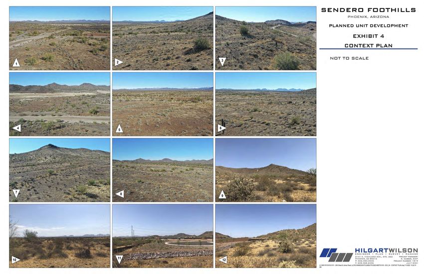
PRINCIPALS AND DEVELOPMENT TEAM
    Land Owner/Applicant
 24th Street and Jomax Road LLC
       1819 E Morten Ave
            Suite 190
     Phoenix, Arizona 85020

   Applicant Representative
         William E. Lally
     Tiffany & Bosco, P.A.
  2525 East Camelback Road,
           Suite 700
    Phoenix, Arizona 85016

           Engineering
        Nguyen Lam, PE
       Hilgart Wilson, LLC
      2141 E Highland Ave
            Suite 250
     Phoenix, Arizona 85016

           Landscape
     Architecture/Planning
     Andy Baron, ASLA LEED AP
              ABLA
     310 E Rio Salado Parkway
         Tempe, AZ 85281

               PLANNED UNIT DEVELOPMENT DISCLAIMER
A Planned Unit Development (PUD) is intended to be a stand-alone document of zoning
regulations for a particular project. Provisions not specifically regulated by the PUD are
governed by the zoning ordinance. A PUD may include substantial background information
to help illustrate the intent of the development. The purpose and intent statements are
                                                                                  2|Page
not requirements that will be enforced by the City. The PUD only modifies zoning ordinance
regulations and does not modify other City Codes or requirements.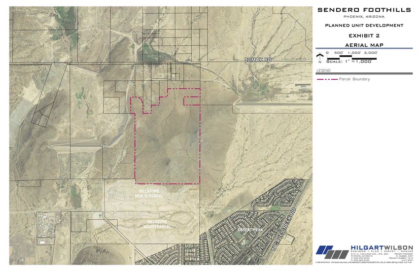
Table of Contents
A Purpose and Intent ........................................................................................................................................................................4
1 Project Overview ..........................................................................................................................................4
2 Project Goals ................................................................................................................................................5
3 Conformance With the General Plan 2015.....................................................................................................6
4 Conformance With the North Land Use Plan .................................................................................................6
5 Overall Design Concept.................................................................................................................................7
B Land Use Plan ................................................................................................................................................................................7
C List of Uses ....................................................................................................................................................................................8
1 Permitted Uses.............................................................................................................................................8
2 Temporary Uses ...........................................................................................................................................8
3 Accessory Uses .............................................................................................................................................8
D Development Standards ................................................................................................................................................................8
1 Development Standards ...............................................................................................................................8
2 Landscape Standards ..................................................................................................................................10
3 Parking.......................................................................................................................................................14
4 Fences / Walls ............................................................................................................................................12
5 Lighting Plan...............................................................................................................................................14
E Design Guidelines ........................................................................................................................................................................15
1 Purpose & Intent ........................................................................................................................................15
2 Site Design .................................................................................................................................................15
3 Architectural Design ...................................................................................................................................16
4 Open Space & Landscape ............................................................................................................................19
5 Shade ........................................................................................................................................................27
6 Walls & Fences ...........................................................................................................................................27
7 Lighting Plan...............................................................................................................................................28
8 Signs ..........................................................................................................................................................29
F Sustainability ...............................................................................................................................................................................29
1 Developer Enforced Standards....................................................................................................................29
2 City Enforced Standards..............................................................................................................................30
G Infrastructure ..............................................................................................................................................................................30
1 Water and Sewer........................................................................................................................................30
2 Circulation..................................................................................................................................................31
Exhibits
Exhibit 1 Legal Description .........................................................................................................................................................................33
Exhibit 2 Site Aerial Map ............................................................................................................................................................................36
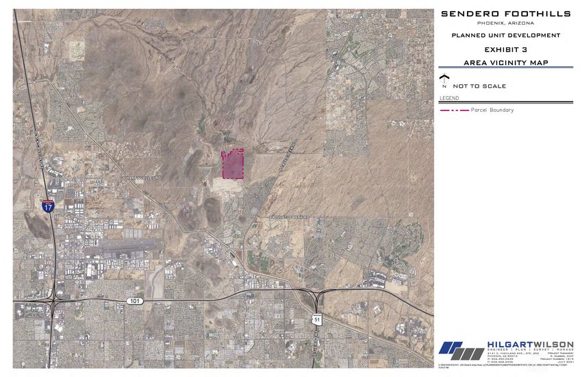
Exhibit 3 Area Vicinity Map ........................................................................................................................................................................38
Exhibit 4 Context Plan ................................................................................................................................................................................40
Exhibit 5 Existing & Proposed Zoning Map ..................................................................................................................................................45
Exhibit 6 Comparative Zoning Table ...........................................................................................................................................................47
Exhibit 7 General Plan Map ........................................................................................................................................................................49
Exhibit 8 Conceptual Land Use Plan ............................................................................................................................................................51
Exhibit 9 Color & Materials Palette .............................................................................................................................................................53
Exhibit 10 Open Space Master Plan ..............................................................................................................................................................55
Exhibit 11 Landscape Master Plan ................................................................................................................................................................57
Exhibit 12 Conceptual Pocket Park 1.............................................................................................................................................................59
Exhibit 13 Conceptual Pocket Park 2.............................................................................................................................................................61
Exhibit 14 Hillside Edge Condition ................................................................................................................................................................63
Exhibit 15 Wash Edge Condition ...................................................................................................................................................................65
Exhibit 16 Street Edge Condition ..................................................................................................................................................................67
Exhibit 17 Wall Plan .....................................................................................................................................................................................69
Exhibit 18 Wall Details .................................................................................................................................................................................71
Exhibit 19 Primary Entry Monument ............................................................................................................................................................73
Exhibit 20 Secondary Entry Monument ........................................................................................................................................................75
Tables
Table 1 Land Use Plan ...............................................................................................................................................................8
Table 2 Single Family Detached Development Standards ...........................................................................................................9
Table 3 Singled Family Attached Development Standards ..........................................................................................................9
Table 4 Condo/Multifamily Development Standards................................................................................................................10
Table 5 Single Family Landscape Standards..............................................................................................................................10
Table 6 Multifamily Landscape Standards ................................................................................................................................12
Table 7 Minimum Common Area Open Space ..........................................................................................................................21
Table 8 Shade Standards .........................................................................................................................................................27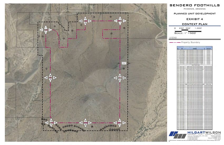
SENDERO FOOTHILLS
               PLANNED UNIT DEVELOPMENT NARRATIVE

A.      PURPOSE AND INTENT
1. PROJECT OVERVIEW

     24th Street and Jomax Road, LLC, Sendero Foothills LLC and Sendero West LLC (the
     “Property Owners” and “Applicant”) are requesting to rezone 213.25 gross acres located
     north of the northeast corner of Cave Creek Dam Road and Desert Peak Parkway for
     Sendero Foothills (the “Property”, “Project”, “Community” or “Site”) (see Exhibit 1: Legal
     Description). The Site is currently zoned S-1 and is located in the Desert View Village and
     Council District 2 of the City of Phoenix (the “City”) (see Exhibit 2: Site Aerial Map and
     Exhibit 3: Area Vicinity Map). The Property is currently vacant and includes a large hillside
     area that will be donated to the City as an addition to the Phoenix Mountain Preserve (see
     Exhibit 4: Context Plan). The hillside area donation agreement shall be approved prior to
     Final Site Plan approval, unless otherwise agreed upon.

     This development narrative outlines the request to rezone the Property from S-1 to
     Planned Unit Development (“PUD”) for the development of various residential housing
     types (see Exhibit 5: Existing & Proposed Zoning Map). The Desert View Village has seen a
     multitude of recent developments which include a variety of housing options including,
     single family detached, single family attached, and multi-family. The existing zoning does
     not provide sufficient diversity of lot sizes and residential housing options for the area in
     support of the planning concepts in the North Land Use Plan. The rezoning request
     provides development opportunities for a range of housing types: detached and attached
     single-family homes and/or condominium/multi-family type homes.

     The PUD will voluntarily restrict development to slopes of 20% or less and a maximum of
     250 residential units. This results in an overall gross density of 1.17 du/ac (dwelling units
     per acre). Section 710 – Hillside Development, allows dwelling units permitted in the slope
     area to be transferred to a lower slope category. The proposed 1.17 du/ac density is within
     the parameters of the density allowed within the hillside development area in Section
     710.C.1.a for the slope categories 10% to 14.9% and 15% to 19.9%. In further support of
     ensuring that the development of the Project meets and exceeds the purpose of the
     Hillside section, the PUD contains development standards addressing the edge treatment
     adjacent to the preserved hillside area, enforceable open space standards, and landscape
     and site design guidelines.

     The Sendero Foothills PUD represents a development proposal for a quality residential
     neighborhood. Located at the base of a hillside, which will be donated to the City of
     Phoenix Parks and Recreation Department, the Community will maintain visual and
     physical access to the surrounding mountains and desert environment while being
     sensitive to them. Sensitivity to the desert environment will be demonstrated through
     utilizing minimally intrusive construction and excavation methods and by maintaining
                                                                                 4|Page
visual access to the mountain to the extent possible. The development concept proposes
a maximum of 250 residential units resulting in an anticipated Project maximum density
of 1.17 du/ac for the 213.25 acres. No site plan is included in this PUD request so
establishing the maximum number of dwelling units will enable the development team
maximum flexibility in their product design. Nonetheless, the development shall meet all
development standards. The Community will be sensitive to the surrounding
neighborhoods and natural environment and provide a development opportunity for a
high-quality residential neighborhood with pedestrian connections to the surrounding
mountain preserve.
Development will be limited to the area within the Property up to the 20% slope line. The
development area is located on the northern portion of the Property, along the
westernmost portion and at the southwest corner. The slope analysis shall be submitted
and approved prior to Preliminary Site Plan Approval however, the maximum development
area shall be 93.25 acres and the minimum donated land area shall be 120 acres,
resulting in a minimum 56% of the gross site to be donated to the City as public open
space for the Phoenix Mountain Preserve.
In order for the developer to have maximum flexibility in the design of the Community while
meeting the PUD goals, this PUD draws from both the R1-8 and R-3 development
standards, similar to the Fireside at Norterra, the Fireside at Desert Ridge, and the
Northview at Stone Butte developments in the nearby area. Multiple housing types are
available in the Community and specific development standards are provided for each of
them. Traditional single family detached development standards are based on the R1-8
district regulations, Table A. Single family attached development standards are based on
the R1-8 district regulations, Table B, and multi-family development standards are based
on the R-3 district regulations, Table B. The PUD proposes to amend the development
standards for this unique location by decreasing density, increasing the minimum common
area open space and setbacks, and the addition of a minimum 25’ setback for areas
directly adjacent to the preserve area. The PUD allows the developer to build any of the
different types of residential units within the development area, (see Exhibit 6:
Comparative Zoning Table).
2. PROJECT GOALS
The request for a PUD zoning district will allow the flexibility to develop a high-quality
residential community. The PUD standards will be similar to the R1-8 district for a
traditional single-family detached product, various types of neo-traditional single-family
attached homes (includes auto court, cluster, alley loaded), and similar to the R-3 district
for multifamily development.
It is important to note that the rezoning development options are designed to allow for the
development of standard single-family detached homes in the R1-8 category that include
a variety of lot sizes. The development options also allow for various types of housing
products that could support cluster and alley access garages, and smaller front setbacks
to promote a more pedestrian oriented community.
5|PageThe PUD tool lays out specific development standards tailored only to develop a residential
development. No other uses besides residential development will be allowed on the site,
ensuring compatibility and protection for the surrounding areas for years to come.
3. CONFORMANCE WITH THE GENERAL PLAN 2015
The City of Phoenix General Plan (the “General Plan”) designates the Property as mostly
Future Parks/Open Space or 1 du/acre (see Exhibit 7: General Plan Map). See
accompanying General Plan Amendment, GPA-DSTV-1-19-2, for additional information. In
particular, the Property’s General Plan classification is being amended from Future
Parks/Open Space or 1 du/ac, Parks/Open Space-Publicly Owned, and Residential 0-5
du/ac to Future Parks/Open Space or 1 du/ac, Residential 2-3.5 du/ac, and Residential
5-10 du/ac.
4. CONFORMANCE WITH THE NORTH LAND USE PLAN
The Property is located within the City of Phoenix’s North Land Use Plan area and the
Sonoran Preserve Master Plan’s North Study Area. The Project’s compatibility with the
general intent of each land use plan is detailed below.
The Property is located within the City of Phoenix’s North Land Use Plan area. The North
Land Use Plan extends from just west of Cave Creek Wash east to Scottsdale Road, and
from Carefree Highway south to Pinnacle Peak Road. As shown on the North Land Use
Map, the Property is situated in an area designated Residential 2–5 du/ac. The proposed
density of 1.17 du/ac is slightly lower than the designation but still compatible with the
North Land Use Map designation approved by City Council in June 1996. Moreover, the
PUD’s density is lower than the Tatum Ranch and Tatum Highland subdivisions noted in
the Land Use Plan where densities average 3.3 du/ac. The proposed density will not
determinately alter the surrounding area and is consistent with the overall intention of the
North Land Use Plan.
According to the North Land Use Plan, staff concluded densities as low as one dwelling
unit per acre significantly increased the per unit cost of infrastructure, ultimately making
housing less affordable. Subsequently, in an effort to address the development dilemma
and neighborhood concerns, staff crafted six planning concepts. The six planning concepts
include: 1) Plan for Strategic Land Uses; 2) Preserve Cave Creek Wash as Ecological Spine
of Desert; 3) Recognize Washes as a Development Constraint; 4) Seek Cost Effective
Infrastructure; 5) Maintain Established Character; and 6) Recognize Existing Rights.
This PUD satisfies multiple planning concepts by allowing for strategic land uses and by
permitting a multitude of development standards. The development standards will ensure
an attractive product is produced which will help preserve the surrounding desert and will
present opportunities to develop employment centers throughout the North Land Use Plan
area. This PUD will preserve Cave Creek Wash’s natural flow and will not disturb critical
wildlife linkages. Moreover, this PUD acknowledges the washes located within the North
Land Use Area are a development constraint that must be respected and intends to
6|Pagedevelop strategically by maintaining existing washes where feasible and incorporate them
into the Project, see Section 4.g and 4.i for further details To address the concept of
housing affordability the development team has conducted numerous studies to generally
analyze the most cost-effective infrastructure location and type. The PUD is consistent with
the character of the North Land Use Plan and supports the established character of the
area.
In short, this PUD is consistent with the North Land Use Plan because it enables strategic
land uses, preserves the Cave Creek Wash, recognizes washes as a development
constraint, seeks cost effective infrastructure, and maintains the already established
character of the area.
5. OVERALL DESIGN CONCEPT
This PUD creates development standards and design guidelines that will result in a high-
quality Community connected to the surrounding desert open space, trails, and services
provided by the Sonoran Preserve and Desert View Village. The proposed plan consists of
a maximum of 250 dwelling units over the entire 213.25 acres for an anticipated overall
blended density of 1.17 du/ac; however, because the hillside will be donated to the City
for the Mountain Preserve, the project will only develop on a maximum of approximately
93.25 acres. The development areas are located north, west and southwest of the hillside.
The vision for Sendero Foothills includes the creation of diverse and connected residential
enclaves with focused sensitivity to the natural desert environment. The Sendero Foothills
residents will have unparalleled proximity and access to significant desert amenities such
as the Sonoran Preserve. Through sensitivity to the surrounding views and native desert
landscaping, the development will be buffered from adjacent communities by a
combination of open space and landscape setbacks provided along the Property’s
perimeter. The proposed pedestrian network will provide residents access to the vast
mountain preserves to the south of the development and connectivity to outdoor gathering
places and recreation areas within the community. The Project’s landscaping and site
development will be integrated with the character of the surrounding desert. The overall
design concept will provide for a high-quality living environment that reflects the desert
hillside and surrounding neighborhoods while providing access for hiking and biking to
and within the mountain preserves. In an effort to minimize any disturbance to the hillside
area the development standards have been created to cluster the housing development.
Trails and pedestrian access will incorporate the mountain as an amenity to the
community.
B. LAND USE PLAN
As previously mentioned, only approximately 93.25 acres of the approximately 213.25 gross
acre site will be developable, see Exhibit 8: Conceptual Land Use Plan. A variety of residential
land uses will be permitted within the development area, including single family detached,
single family attached, and multifamily products.
7|PageTable 1 Land Use
Land Use Gross Acres Proposed Development
Development Area 93.25 Single-family attached/detached or Multi-family
Preserved Open Space 120.00 N/A
Total 213.25
C. LIST OF USES
1. PERMITTED USES
a. Single-family residential detached
b. Single-family residential attached
c. Multifamily residential
d. Residential Model Home Complex and Sales Office
2. TEMPORARY USES
Temporary uses shall be subject to Section 708 of the Phoenix Zoning Ordinance.
3. ACCESSORY USES
a. Community Garden in accordance with Section 608 of the Phoenix Zoning Ordinance.
(Accessory Uses are for employees and residents listed under the Permitted Uses and
are not available to the general public.)
D. DEVELOPMENT STANDARDS
1. DEVELOPMENT STANDARDS
Inclusion of Development Standards within the Sendero Foothills PUD protects not only
the adjacent property owners but creates standards reflective of a residential
development sensitive to the surrounding area and its unique location. These standards
permit greater flexibility enabling the development of a higher quality living environment,
as well as benefit public health, safety, and the general welfare of the citizens of the City
of Phoenix. They also promote an appropriate transition to and compatible land use
relationships with the adjacent properties.
The requested PUD development standards are split into three separate tables: Traditional
Single Family Detached, Single Family Attached, and Condo/Multifamily. These
8|Pagedevelopment standards shall apply to all of the development area. The PUD is subject to
all Hillside Development Standards, including but not limited to density restrictions, which
may require deviations from the included exhibits that have not been reviewed for Hillside
compliance. All Hillside Standards and Requirements shall override all zoning standards,
including conflicts with any of the PUD Standards. The PUD Development Standards are
as follows:
Single Family Detached
Table 2
Minimum Lot Width 45’
Min. Lot Depth 110’
Dwelling unit density 3
Common Landscaped setback 20’ average, 15’
adjacent to perimeter streets minimum
Min. setback adjacent to future
preserve areas. 50’
Setbacks (Minimum)
Front 10’
Side 5’; 10’ for dwelling units
along the perimeter
Street Side 10’
Rear 5’
Common Areas (Min.) 20% of gross area*
Max. Building Height 2 stories and 30’
Max. Lot Coverage Primary structure, not
including attached shade
structures: 40%; Total:
50%.
Single Family Attached
Table 3
Minimum Lot Width 45’
Min. Lot Depth 110’
Dwelling unit density 3
Perimeter Standards 20’ average, 15’
minimum
Min. setback adjacent to future
50’
preserve areas.
Setbacks (Minimum)
Front 10’
Side 5’; 10’ for buildings
along the perimeter; 0’
9|Pagefor attached dwelling
units
Street Side 10’
Rear 5’
Common Areas (Min.) 20% of gross area*
Max. Building Height 2 stories and 30’
Max. Lot Coverage Primary structure, not
including attached shade
structures: 40%; Total:
50%.
Condo/Multifamily Development Standards
Table 4
Minimum Lot Width None
Min. Lot Depth None
Dwelling unit density 6
Perimeter Standards 20’ average, 15’
minimum
Min. setback adjacent to future
50’
preserve areas.
Setbacks (Minimum)
Front 20’
Side 10’ for buildings along
the perimeter
Street Side 10’
Rear None (established by
Building Code)
Min. Building Separation 10’
Common Areas (Min.) 20% of gross area*
Max. Building Height 2 stories and 30’
Max. Lot Coverage 50%.
*Common Area is calculated as a percentage of the total project area
2. LANDSCAPE STANDARDS
These development standards shall apply to all of the development area.
Table 5
Single Family Detached & Single Family Attached
Landscape Standards
PUD R1-8
10 | P a g eStreetscape 1) A landscaped setback shall 1) 20’ adjacent to public
be established and maintained streets; this area is to be in
along all Street frontages: common ownership unless
20 ft. average for non- lots front on the perimeter
residential uses (single public street; 15’ adjacent
user) to property line
15 ft. average and 10 ft. 2) Planting Quantity:
minimum for residential One (1) shade tree space
uses twenty (20) to thirty (30)
0 ft. (mixed use building feet on center (based on
located on property line) species) or equivalent
2) Planting Quantity: groupings.
One (1) tree for every Minimum five (5) 5-
twenty (20) feet of Street gallon shrubs per tree
frontage. 3) Planting size:
Five (5) shrubs shall be Minimum 60% 2” caliper
planted for each tree. and 40% 1” caliper
3) Planting Size (within one (1)
years growth:
75% of trees shall have
a 2 inch caliper,
25% of trees shall have
1” caliper
4) Additional Requirements for
Landscaping Located within the
rights-of-way:
Turf is prohibited.
Plant materials utilized
must be included on the
most recent edition of the
Phoenix Active
Management Area Low
Water Using Plant List.
Onsite Landscape 1) A minimum of seventy-five 1) Minimum 50% living
percent (75%) of all landscape vegetation shall be provided
areas at maturity shall be 2) All private pedestrian
planted with living shrubs, pathways and public sidewalks
vegetated ground cover, and/or shall be shaded to 50 percent
turf.
2) Turf area shall be limited to
a maximum of 30% on all
streetscapes.
3) All private pedestrian
pathways and public sidewalks
shall be shaded to 50 percent
Sidewalks Sidewalks shall be a minimum N/A
of five feet wide, and shall be
11 | P a g eseparated from the curb by a
minimum five foot wide
landscape strip. The landscape
strip shall be planted with a
minimum of groundcover at a
rate of 5 (five) five-gallon shrubs
per 500 square feet of
landscape area.
Table 6
Condo/Multifamily Landscape Standards
PUD R-3
Streetscape 1) A landscaped setback shall 1) 20’ adjacent to public streets;
be established and maintained this area is to be in common
along all Street frontages: ownership unless lots front on
20 ft. average for non- the perimeter public street; 15’
residential uses (single adjacent to property line
user) 2) Planting Quantity:
15 ft. average and 10 ft. One (1) shade tree space
minimum for residential twenty (20) to thirty (30) feet
uses on center (based on
0 ft. (mixed use building species) or equivalent
located on property line) groupings.
2) Planting Quantity: Minimum five (5) 5-gallon
One (1) tree for every shrubs per tree
twenty (20) feet of Street 3) Planting size:
frontage. Minimum 60% 2” caliper
Five (5) shrubs shall be and 40% 1” caliper
planted for each tree.
3) Planting Size (within one (1)
years growth):
75% of trees shall have
a 2 inch caliper;
25% of trees shall have
1” caliper
4) Additional Requirements for
Landscaping Located within the
rights-of-way:
Turf is prohibited.
Plant materials utilized
must be included on the
most recent edition of the
Phoenix Active
Management Area Low
Water Using Plant List.
Onsite 1) A minimum of seventy-five 1) Minimum 50% living vegetation
Landscape percent (75%) of all landscape shall be provided
12 | P a g eareas at maturity shall be 2) All private pedestrian pathways
planted with living shrubs, and public sidewalks shall be
vegetated ground cover, and/or shaded to 50 percent
turf.
2) Turf area shall be limited to
a maximum of 30% on all
streetscapes.
3) All private pedestrian
pathways and public sidewalks
shall be shaded to 50 percent
Parking Lot 1) Five percent (5%) of the 1) 5% of the surface parking lot,
surface parking lot shall be exclusive of perimeter landscape
landscaped. Landscaping shall setbacks, must be landscaped.
be dispersed throughout the 2) A minimum of one (1) 15 gallon
parking area. canopy shade tree for every 10
2) All parking areas shall be vehicle parking spaces shall be
screened from view from planted in a landscape island.
adjacent streets and lots to a Islands and planters shall be a
minimum height of three (3) minimum of 5’ wide with a depth
feet above the nearest adjacent equal to that of the parking space.
paving grade by means of a
combination of walls,
undulating berms and
landscaping consisting of
minimum 5-gallon shrubs.
Shrubs used for screening shall
be of an evergreen variety.
3) Landscape Planters:
At ends of each row of
parking and for every ten
(10) parking spaces.
Each landscape island
shall contain one (1) tree
(60% 2-inch caliper, 40%
1 inch caliper) and five
(5) shrubs (5 gallon).
Sidewalks Sidewalks shall be a minimum N/A
of five feet wide, and shall be
separated from the curb by a
minimum five foot wide
landscape strip. The landscape
strip shall be planted with a
minimum of groundcover at a
rate of 5 (five) five-gallon shrubs
per 500 square feet of
landscape area.
13 | P a g ei. All plant material shall be in compliance with the Department of Water Resources
low water use plant list as approved by the City of Phoenix Planning and
Development Department.
ii. All irrigation systems shall be designed, constructed and maintained to promote
water conservation and prevent water overflow or spray onto streets, sidewalks or
parking areas.
iii. Landscape irrigation and domestic water services shall be metered separately.
iv. A minimum of fifty percent (50%) coverage shall be maintained in all landscape
areas at maturity with living trees, shrubs, accent plantings, and vegetated ground
cover.
v. Dust control products, such as decomposed granite, river rock, and ground cover,
will be installed at a minimum of two-inches thick in all landscape areas.
3. PARKING
The parking for this PUD shall comply with Section 702 of the City of Phoenix Zoning
Ordinance.
4. AMENITIES
a. Open space shall be exclusive of street tracts, lots, and landscape setbacks.
b. Pedestrian access to mountain preserves from Project pedestrian network.
c. A minimum of twenty percent (20%) of the gross site area shall be used as common
area. A minimum of 5% of the 20% common area shall be dedicated to usable open
space accessible to the residents. This usable open space may be active or passive
open space.
d. Amenities throughout Sendero Foothills open spaces shall include at a minimum six
(6) of the items listed below. Amenities will be equitably located throughout the
development area. Additional amenity details are provided in Section E.4.e below.
i. Community trails
ii. Ramada with trellises
iii. Seating areas
iv. Turf
v. Gathering space
vi. BBQ’s
vii. Picnic Benches
viii. Playground
e. Required open space may be used for storm water retention and shall comply with
507 Tab A – II.A.2.
5. LIGHTING PLAN
The Sendero Foothills PUD shall comply with lighting standards as defined within the
Environmental Performance Standards and the Guidelines for Design Review Section of
the Phoenix Zoning Ordinance.
14 | P a g eOutdoor lighting fixtures shall incorporate light cut off shielding as necessary to direct light
downward and away from any residential use existing as of the date of this PUD approval.
Lighting may need to be controlled and mitigated through the use of mature landscape
buffers or other shielding techniques as approved by the Planning and Development
Department.
The maximum height for all landscape and site lighting within the developable area will be
fifteen feet (15’) and the value of the light foot candles at the property lines shall not
exceed a one-foot (1’) candle. Photometric plans shall be submitted with the site plan
review and final light fixture sections shall be provided at the time of final design. All
lighting will reflect the character of the surrounding environment and be consistent with the
City’s dark sky and lighting provisions.
E. DESIGN GUIDELINES
1. Purpose & Intent
The design guidelines for any single family detached development, single family attached
development, or condominium/multifamily development will adhere to the City’s general
design review guidelines specified by Section 507 Tab A of the City’s Zoning Ordinance.
Namely, the development will minimize the removal of existing healthy Sonoran Desert
vegetation and will maintain the natural washes, hillside, and vegetation whenever
possible. A slope analysis shall be submitted and approved prior to Preliminary Site Plan
Approval and limits of disturbance shall be determined at final design to determine the
amount of natural area that may be disturbed. Landscape inventory and salvage plans
shall be provided at site plan review to determine natural landscape material that can be
used in the development of the community.
2. Site Design
The objective of the site design for the project is to minimize the visual impact of the Site
as well as integrate it seamlessly into the surrounding environment. This is done
through orientation, placement, vegetation, and open space, see Section 4.g, 4.h and
4.i for further details. The site design shall include the following elements and shall
comply with the City of Phoenix Zoning Ordinance Section 507, Tab A (Guidelines for
Design Review):
a. Orient developments to take advantage of the proximity to the Sonoran Preserve and
existing hiking trails.
b. Main entrances shall utilize vegetation, trees, and signage that will be designed with
desert-sensitive materials and colors, and accent landscaping that enhances and
creates an aesthetically pleasing “entrance” into the development.
c. Pedestrian connectivity will be provided to all trails, open space, and community
gathering places.
15 | P a g ed. Pedestrian “way finding” signage will be provided and will be very clear and direct.
e. The development will include decorative signage and decorative site lighting to
enhance the native landscaping and architecture.
f. The front face of homes shall be parallel to the street frontage (or tangential to the
street frontage in the case of a curved street, knuckle, or cul-de-sac) regardless of the
shape of the lot.
g. Individual residences are encouraged to emphasize diversity and scale along the
street, minimizing visual monotony.
h. Windows and balconies will be oriented towards open spaces where possible.
i. Any site trash enclosure shall provide screening designed to be 8’ high and will fully
screen the containers within. The enclosure will be composed of CMU with an exterior
finish that matches the exterior of the main building. The access gates are to be fully
obscured with solid metal panels and painted to match one of the building colors.
3. Architectural Design
a. Color Palette
Colors will be as illustrated on Exhibit 9: Color and Materials Palette.
b. Materials
The design of the community will strive for integration into the existing surrounding
community while establishing a significant presence in the neighborhood. High-
quality building elevations require the use of a variety of materials, particularly in the
details of the façade design. All buildings shall exhibit four-sided architecture and
shall conform to the following Architectural Subdivision Design Standards.
Architectural Subdivision Design Standards:
i. No two identical elevations or floorplans shall be placed side-by-side or directly
across from one another
ii. Three (3) different elevations are required on each side of the street
iii. Building and garage setbacks should ensure that each home has a different
position than the next.
iv. Varied front yard setbacks for porches, living spaces, and garages should be
utilized to provide breaks in the street scene making it more visually
interesting
v. Minimize the visual impact of garage doors through setbacks, colors and styles
c. Special attention is to be paid to the garage presence on the streetscape. Reducing
the garage dominance on the streetscape creates street scenes that are inviting
and safe. Garage doors shall be recessed a minimum of 8” and shall include a
minimum of two (2) of the following garage configurations.
i. Shallow–Recessed
16 | P a g eii. Mid-Recessed
iii. Deep-Recessed
iv. Swing-in
v. Tandem
vi. Split
vii. Split with casita
viii. Rear facing
ix. Three (3) car offset
x. Alley
xi. Motor court
Any and all buildings faces cannot be comprised of more than sixty (60) percent
stucco and shall have a minimum of three (3) of the Design Elements listed below.
The list of Design Elements for Four-Sided Architecture is not an exhaustive list and
may include other elements that are consistent with the list below.
Design Elements for Four-Sided Architecture:
xii. Board and batten
xiii. Clapboard siding
xiv. Wood/heavy timbers
xv. Adobe
xvi. Stone or tile veneer
xvii. Stucco
xviii. Shutters or other window treatments
xix. Recessed windows
xx. Juliette balcony
xxi. Window pop out and embellishments
xxii. Metal accents
xxiii. Pitched roof elements shall be required when appropriate for the architectural
style proposed
xxiv. If flat roofs are proposed a false front parapet shall be included
xxv. Overhang wooded eaves and exposed rafters shall be required
d. Elevations
Single Family
i. Front elevations shall incorporate all of the following:
• A variety of distinct roof styles is encouraged
• Architectural detailing appropriate to the style of the home
• Accent colors and materials
• Outdoor living spaces such as covered front porch, patio, entry
courtyard, or second story balcony
• A focal entry point such as detailed window treatment and
articulation, or unique accent materials
• No two identical elevations or floorplans shall be placed side-by-side
or directly across from one another;
ii. Colors and materials:
• A minimum of six (6) color schemes are required for each builder
17 | P a g eproduct series for each neighborhood. The following criteria should
be considered:
- Colors should be chosen to enhance the overall character of
the neighborhood
- Colors should contribute to distinguishing the architectural
character of the home
- Diversity of color is encouraged
- Colors and materials should elevate architectural interest
- Material change must occur at logical break points
- Materials and colors must be varied to add texture and depth
to the overall character of the neighborhood
- Columns, towers elements, and pilaster must be wrapped to
logical break points as appropriate
- Material breaks at garage corners should end on an internal
corner
- White garage doors are discouraged unless appropriate for
the proposed architectural style
- Use durable roofing and siding materials to reduce the need
for replacement (metal roofing and shingled roofs are
permitted when architecturally appropriate.)
iii. Rear elevations will incorporate the following:
• Variation in roof forms, building planes, and/or massing
• Pop-outs appropriate to the style of the home
• If a covered patio is provided, it will include a roof treatment consistent
with the main portion of the home
iv. Private outdoor open space shall be required for the home and shall conform
to the list below:
• Porches shall be a minimum of six (6) feet deep. The lengths of the
porch shall vary depending on the appropriate architectural selection
• Patios shall be a minimum of six (6) feet deep. The lengths of the patio
shall vary depending on the appropriate architectural selection
• Internal courtyards may be used when architecturally appropriate.
When used, all courtyards shall be a minimum of sixty (60) square feet
in area
• When used, and excluding juliette balconies, private balconies shall
be a minimum of sixty (60) square feet.
v. Windows will be recessed or popped out from the exterior building face a
minimum of one (1) foot
vi. Trim will be provided on all window and door openings
Multifamily
i. Windows and balconies will face open spaces where possible
18 | P a g eii. All buildings will borrow and incorporate architectural styles, materials, forms,
colors, and compatible elements from the same site
iii. Monotonous elevations will be avoided and building accents will be expressed
through differing quality materials and/or details
iv. All exterior building exit and entrances for condominium or multifamily shall
provide weather protection that are a minimum of 6 feet in width and 4 feet in
depth
4. Open Space & Landscape
The Property’s open space and landscape design concepts include elements that enhance
view corridors, provide focal elements and natural environments, promote visually and/or
physically usable open spaces that are accessible and safe. (see Exhibit 10: Open Space
Master Plan and Exhibit 11: Landscape Master Plan).
a. Landscape Character
The Property’s landscape character is comprised of an indigenous Sonoran Desert
palette with transitional ornamental materials. The composition of the landscape will
blend native style planting along the perimeter and natural edges of the property where
existing native landscaping occurs, with more ornamental or structured planting in
focal areas. Landscape materials will be designed to limit visual obstructions; this can
be accomplished through appropriate plant palettes, plant sizes, and regular
maintenance. Playing off the existing character of the area, authentic and natural
materials, along with a patterned landscape will be utilized.
The overall design approach for the Property is based on highlighting the natural desert
features and preserving significant topography. The hillsides, trails, and recreation
features located throughout the Property create numerous health and wellness
opportunities.
b. Entry Planting Concept
Entry areas shall include a focal landscape area intended to reinforce a sense of
arrival. These areas will be the most heavily planted and will include plant massing that
features plants with an emphasis on texture and color. The following will be considered
at all entries:
i. Trees shall be located and grouped to maximize pedestrian shading
ii. Where appropriate, additional trees shall be included in an entry median where
design permits
iii. Shrub and groundcover material shall provider a minimum of 50% live coverage
of the landscape areas
iv. Landscape lighting may be provided for all trees located at entries
19 | P a g ev. Turf is prohibited
c. Street Tree Program
i. A street tree program is encouraged but not required as part of the Project
design. It may occur within the front yard building setback. Where a street tree
program is implements, residential streets should have street trees planted
approximately twenty-five feet (25’) on center, except where driveways,
sidewalks, or easements restrict planting. The minimum tree size shall be 1”
caliper. The trees should be planted between four (4) feet and eight (8) feet
behind the sidewalk, or curb is no sidewalk exists, or between curb and
sidewalk. Landscaped areas along local streets shall not be planted with any
plant material that will impede or injure pedestrians or block sight lines of
automobiles.
d. Open Space
The property consists of and is bordered by a significant amount of undeveloped land,
primarily mountain hillside. The Property benefits from the abutting hillside and
adjacent natural open space areas. Open spaces, both natural and developed, are
integral to creating a healthy, sustainable, and inviting community. In addition to a
significant amount of the Property being donated to the City for inclusion in the Phoenix
Mountain Preserve a minimum 5% of the Project common area will be provided as
usable common open space in the development area. The Project common area shall
include natural open space, usable open space - passive and active, and landscaped
areas. Sidewalks and trails shall be provided throughout the Community to provide
connectivity to the common open space and the natural preserved hillside area open
space. In total, a minimum of 20% of the project gross area shall be provided as
common area and a minimum 5% of the common area shall be usable common open
space, both active and passive. Refer to Table 7, Minimum Common Area Open Space.
i. Preserve area/Natural Open Space: Approximately 120 acres of the gross area
of the Property shall be donated and preserved as undisturbed hillside and
natural open space. Such a large quantity of natural open space allows for the
preservation of the native vegetation, maintains visual access to the hillside
and protects the character of the area. Residents shall have access to trails
within the preserved hillside area.
ii. Usable Common Open Space: A minimum of 5% of the 20% common area shall
be dedicated to usable open space accessible to the residents. This usable
open space may be active or passive open space. It is comprised of two (2)
Amenity Areas, trails, and landscape areas within the development area. The
amenity areas shall include program features as specified below. The trails and
associated amenities shall be easily accessible to residents; supporting
20 | P a g erecreation activities and social interaction within the community. Exhibit 12:
Conceptual Pocket Park 1 and Exhibit 13: Conceptual Pocket Park 2.
Table 7 ****Minimum Common Area Open Space
Common Area Open Space *20%
Preserved/Natural Open Space **120 ac
Usable Open Space ***5%
* Common Area open space shall be calculated based on the gross project area
** Preserved/Natural Open Space shall be a minimum of 120 acres and
determined from the land area donated to the Parks and Recreation Department
of City of Phoenix.
*** Usable Open Space shall be calculated as 5% of the 20% Common Area
Open Space Acreage.
**** Acreages and percentages are subject to change based on final lotting
design not available at time of Zoning.
e. Amenity Areas
The amenity areas (“Amenity Areas” or “Pocket Park” or “Pocket Parks”) shall include
program features as specified below to provide for recreational uses. The Pocket Parks
focus on health and wellness experiences within the outdoor environment. All Pocket
Parks are to be centrally located within the developable areas to provide equitable
access for all residents to use. Each Pocket Park shall include a minimum of three (3)
of the program features described below.
i. Program features (the list provided is not exhaustive and may include other
program that is consistent with the list below):
a. Benches
b. Gas fire pits
c. Pet waste stations
d. Cactus/specialty garden
e. Seating nodes
f. Play equipment
g. Exercise and stretching stations
h. Themed signage/trail markers;
i. Open play turf areas
j. Outdoor games and communal lawn games
k. Shaded tree grove
l. Shade structure (min. 100 sf)
Pocket Parks should become a focal element within the community and meet the
recreation needs of the residents. The materials and finishes shall be consistent with
21 | P a g ethe design of the community. Utilizing a mixture of fabricated and natural shade
features promote a healthy lifestyle focused on the outdoor environment.
f. Landscape Lighting
The use of landscape lighting in common areas shall be encouraged to promote
community aesthetics and a safe pedestrian environment. Thoughtful use of lighting
shall be encouraged in areas of higher activity and discouraged in low activity areas to
reinforce the goals of the City’s dark sky provisions.
i. Lighting that causes glare, discomfort, or disruption of the visual environment
of neighboring homes or development is prohibited
ii. Shrubs will be used to conceal landscape light fixtures
iii. Lighting controls will not be visible from the street
iv. Landscape lighting will blend into the landscape
v. Security lighting will be designed and installed in a manner that promotes the
safety of pedestrian and vehicular movements
vi. Lighting in amenity areas will be shielded to reduce lighting impacts on adjacent
lots or developments
g. Edge Conditions
The Sendero Foothills community is located at the base of a mountain that it surrounds
on three sides. This mountain will be an attractive amenity for the community. By
developing criteria for edge treatment conditions, the goal will be to enhance the
interaction between the natural environment while offering development opportunities
for the Project, which is anticipated to ultimately benefit the residents of the
community. Steeper sloped areas of the mountain will be donated to the City of
Phoenix to be incorporated into the overall Phoenix Mountain Preserve and will serve
as a public asset by protecting native desert lands. Sensitivity to the natural desert
environment is a key design element of the Project and consideration has been given
to the interface between the community and the hillside to ensure appropriate and
sensitive transitions between them.
Edge Treatment Design Guidelines
The purpose and intent of the Edge Treatment design guidelines is to create a
community that respects the hillside and sensitive desert environment. The edge
treatment design guidelines apply to the “Property Perimeter” (Property Perimeter
consists of all property adjacent to the proposed preserve land boundary) and are as
follows:
Site Design
• The hillside is an amenity. Where development occurs near the hillside,
development will be permitted on the areas below the 20% slope line, to
maintain a visual amenity for the region and establish opportunities for
connectivity between the hillside and the Sendero Foothills development.
• Maintain access to the natural preserve area from developed edges of the
22 | P a g ecommunity.
• Focus site layout and design on the proximity of the hillside. Project perimeters
shall be designed to include open areas and view corridors that provide visual
and physical access to the hillside and natural desert environment.
• Provide community controlled pedestrian access points to the hillside.
• Manage stormwater via the natural wash system to the extent possible.
• Preserve significant washes such that they serve multi-purposes, including
drainage, recreation, wildlife habitat/corridors and amenities.
• Lots that back up or side to the Property Perimeter shall accommodate
drainage, utilities and necessary maintenance access on private land below the
20% slope line.
• Create standards or parameters for the transitional edge between the
developed area and the preservation area. This transition area will be “organic”
and flexible to maintain a free flowing natural appearance, not a fixed
dimension.
1) All native landscaped areas disturbed by construction will have a
minimum of 25 feet (25’) and a maximum of 50 feet (50’) of
revegetated landscape area beyond the disturbed areas as needed
to maintain a natural appearance. The intent is to preserve native
landscaped areas to the extent practical and limit the revegetated
landscape area, and blend revegetation with the native edges. All
improvements shall be a minimum of 25’ away from the 20% slope
line to provide adequate transition and revegetation. Where
improvements are proposed below the 20% slope line, a minimum
of 25’ and a maximum of 50’ of revegetated landscape area shall be
provided measured from the back of the improvement.
2) Revegetation shall include the following:
• Scarification of existing ground plane
• Shaping of earthen slopes to daylight in organic forms to
blend with existing conditions
• Application of hydroseed based on the seed mix as noted on
Exhibit 11: Landscape Master Plan
• Where immediately adjacent to the preserve land a minimum 50% of the total
developed area shall consist of Open Edge Treatment. Open Edge Treatment
includes:
23 | P a g eYou can also read