Revised Structural Model For The Tuzla Geothermal Field In Northwest Turkey Based On Moment Tensor Analyses From A 2017 Earthquake Swarm
←
→
Page content transcription
If your browser does not render page correctly, please read the page content below
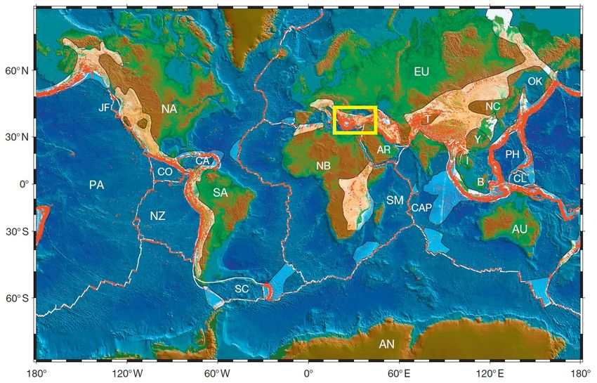
GRC Transactions, Vol. 41, 2017

 Revised Structural Model For The Tuzla Geothermal Field
 In Northwest Turkey Based On Moment Tensor Analyses
 From A 2017 Earthquake Swarm

 Metin Tavlan1 and Erol Gurcan2
 1
 Transmark Renewables, 2Enther Energy

Keywords
Geothermal, Exploration, Geology, Turkey, Conceptual Model, Stress Field

 ABSTRACT

Although the basic conceptual elements of the Tuzla Geothermal Field in northwest Turkey have
been established by surface exploration methods and drilling, a moment tensor analysis from a
2017 earthquake swarm has suggested a revision of the structural model for the field upflow,
hinting at new exploration strategies.
Most of the roughly 120˚C to 150˚C production supporting about 15 MWe at Tuzla is from a
volcanic reservoir at 300m to 1,000m depth heated by upflow from fractured granitic and
metamorphic rocks. Although wells did not absolutely constrain it, the upflow had been assumed
to originate along the Tuzla fault, which is a NW-SE trending active normal fault, attributed to
antithetic Riedel shears of the NE-SW trending crustal scale North Anatolian Fault.
The Tuzla fault and, therefore, the upflow zone, were modeled as being very steep based on
surface kinematic data. However, moment tensor data obtained from early 2017 earthquakes
elicited a potential listric geometry, suggesting a broader region to target wells on the upflow
zone. Besides, further exploration is expected to discover similar prospective faults within the
same tectonic domain.

1. Introduction
Located in one of the most active tectonic settings of the Earth’s crust (Figure 1), Turkey has
proven geothermal power potential. Although direct geothermal heat has been used since ancient
times and exploration surveys started decades ago, it was not until 2007 that regulation allowed
private companies to enter the geothermal market. Notwithstanding that, Turkey has been
executing a fast development over the last decade and geothermal electric power production
capacity has grown to 858 MW by March 2017 according to Republic of Turkey Energy Market
Regulatory Authority (EMRA; http://www.emra.org.tr). Targeting to reach 1.5 GW by 2023
Tavlan and Gurcan

(100th anniversary of the Republic), the estimated geothermal electric power potential of Turkey
is 4.5 GW (TJD, 2013).

Figure 1: Plate tectonics and seismicity (red dots) map (Wessel and Muller, 2015) and the location of Turkey
 (yellow rectangular). Plate abbreviations: B, Borneo; AN, Antarctica; AR, Arabia; AU, Australia; CA,
 Caribbean; CAP, Capricorn; CL, Caroline; CO, Cocos; EU, Eurasia; I, Indo-China; IN, India; JF,
 Juan de Fuca; NA, North America; NB, Nubia; NC, North China; NZ, Nazca; OK, Okhotsk; PA,
 Pacific; SA, South America; SC, Scotia Sea; SM, Somalia; Y, Yangtze; T, Tarim Basin; PH, Philippine.

The vast majority of geothermal electric development studies in Turkey is carried out in the
largest two basins: Buyuk Menderes and Gediz grabens in western Turkey (Figure 2). 32 out of
35 operating power plants in Turkey are constructed in Aydin, Denizli and Manisa provinces
located within the depression areas along these Late Tertiary graben structures. Although some
shallow wells are present, most of the geothermal drillings in these graben-controlled basins
targeted fractured metamorphic rocks of the Menderes Massif located 3000-4000m below
surface. The other geothermal field –Tuzla, in NW Turkey– where the two of remaining power
plants are located, has been considered to have relatively less potential. In addition to these
regions, recent finding of a 295˚C well in Cappadocia (central Turkey) points toward a new
major geothermal field to produce electricity.
With natural hot springs up to 100 ˚C, shallow wells with bottom hole temperature of above 170
˚C and two geothermal power plants built, the Tuzla Geothermal Field –which has remained in
the shadow of BMG and GG– should not be underestimated. Although the largest market players
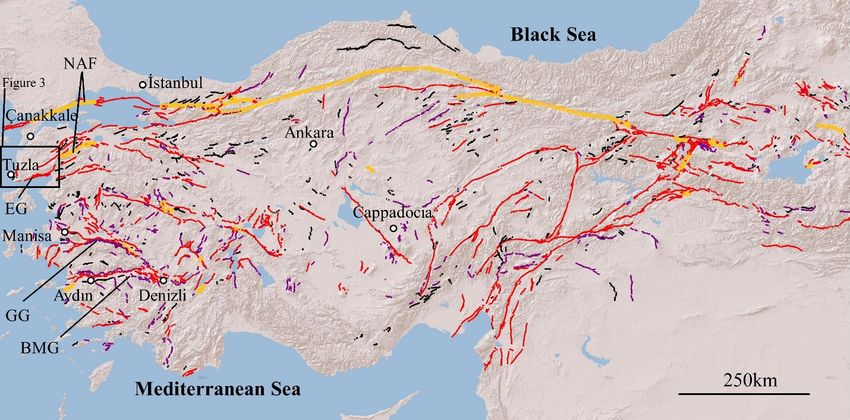
Tavlan and Gurcan

are not involved, geothermal developers in Tuzla region carried out extensive exploration
surveys to understand the nature of the geothermal system.
Geology, geophysics, geochemistry, hydrogeology, structural geology and well data were used to
create conceptual models. However, the recent earthquake swarm in the region provided game-
changing information, which compels reconstruction of the conceptual model.

Figure 2: Major geothermal fields and neotectonic structures (color curves) in Turkey. BMG, Buyuk
 Menderes Graben; GG, Gediz Graben; EG, Edremit Graben; NAF, North Anatolian Fault.

In this study, former thoughts and new suggestions are presented in a conceptual perspective
focusing on the change in the structural model. However, it should be noted that the figures with
cross-sections emphasizing the model include geologic detail but no well tracks or scale for
proprietary reasons.

2. Review Of The Geological History
Turkey as a link of Alpine-Himalayan orogenic belt is exposed to N–S contraction by northward
movement of Arabian plate (e.g. Sengor et al. 1985; Yilmaz, 1993; Robertson and Grasso, 1995;
Okay, 2008) (Figure 1). The North Anatolian Fault (NAF) is the largest structure releasing the
stresses built-up by the contraction (Figure 2). Central Anatolia has been escaping towards west
along the transform fault segments of NAF (e.g. Barka 1992; Sengor et al. 2005).
Tuzla Geothermal Field is located in the southwestern end of the Biga Peninsula in NW Turkey
(Figure 2). The Biga Peninsula is composed mainly of three tectonic belts: metamorphic Sakarya
and Ezine zones and an accretionary complex of Cretaceous Cetmi Melange disassembling the
other two along a NE–SW trending zone (Figure 3) (MTA, 2012). Lithostratigraphy of the
lowermost parts of the Sakarya and Ezine zones show comparable Precambrian-Early Paleozoic
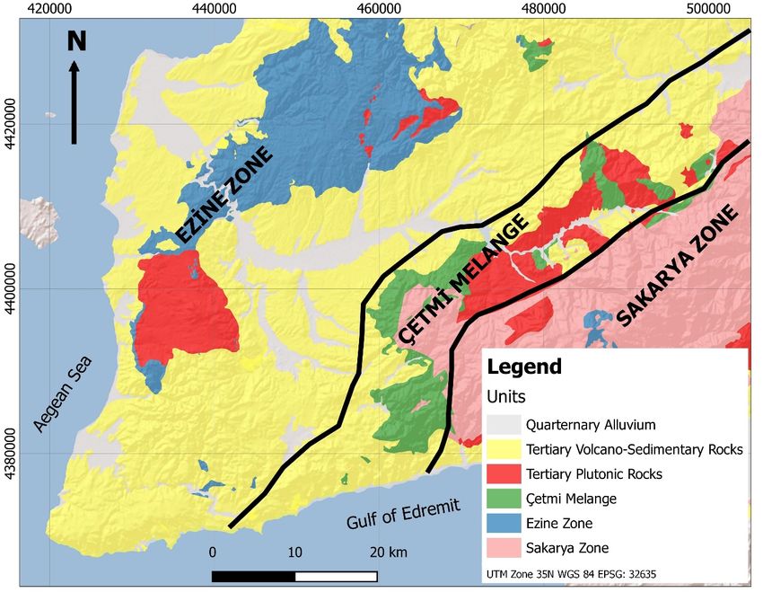
Tavlan and Gurcan

metamorphic assemblages (Tunc et al. 2012). However, Ezine Group, which is the basement of
the Tuzla Geothermal Field (part of the Ezine Zone), show diversified lithology then the rest of
the Biga Peninsula: it is thought to be a margin of Rhodope Massif which recorded the opening
of Maliac/Meliata oceanic basin (e.g. Okay et al., 1991; Beccaletto, 2004; Beccaletto and Jenny,
2004; MTA, 2012).

Figure 3. Regional geological map of Biga Peninsula (modified after MTA, 2012). Black lines denote
 boundaries of the tectonic belts.

Ezine Group is composed of Precambrian-Early Paleozoic Geyikli Formation, Mid-Late Permian
Bozalan Formation and Early-Mid Triassic Camkoy Formation. From bottom to top, terrigenous
detritals, platform type limestones and rift related debris flow and carbonate turbidite are the
protolith of the slightly metamorphic sequence thicker than 2,000m (Beccaletto and Jenny 2004;
MTA, 2012; Tunc et al. 2012). The Early Cretaceous Denizgoren ophiolite overlays Ezine Group
by an overthrust (Okay et al. 1996; Beccaletto and Jenny 2004).
Eocene-Mid Miocene calc-alkaline magmatism led to Late Oligocene-Early Miocene Q-
monzonite/ granodiorite intrusion (i.e. Kestanbol Granitoid) in the west of Biga Peninsula
(Altunkaynak and Genc, 2008). The concurrent and subsequent wide-spread Miocene volcanism

Tavlan and Gurcan

(andesitic to basaltic lava and pyroclastics) and Miocene to Quaternary continental sediments
covered the basement units.
Although the lithologic properties of the basement rock are suitable to be a good reservoir rock,
geothermal wells drilled in Tuzla highlighted that the Miocene volcanics overprinted the old
fault network and karstic cavities in several localities. In other words, the faults, formed in the
neotectonic period, mainly control the current geothermal fluid movement.

3. Tectonics Controls On The Tuzla Geothermal Field
The Biga Peninsula has been affected by extensional neotectonics of the western Anatolia and is
being controlled by three different tectonic systems. The north of the area is dominated by the
NE-SW right-lateral strike-slip NAF. As a part of the NAF, Bababurnu tectonic domain presents
NW-SE fault clusters in the SW of the peninsula (Yaltirak et al. 2012). Additionally, the Edremit
Graben bounding the south of the peninsula extends approximately E-W to ENE-WSW (Figure
4).

Figure 4: Major structural components of the Biga Peninsula. Bababurnu tectonic domain is constrained by
 two major faults: NAF southern segment and Edremit Graben. The beach ball focal planes from the
 largest three pulses of the 2017 earthquake swarm indicate the trend of antithetic conjugate of Riedel
 shears (R’) with normal/oblique faulting. Moment tensors and earthquake data are obtained from
 www.deprem.gov.tr (Disaster and Emergency Management Authority of Turkey, AFAD).
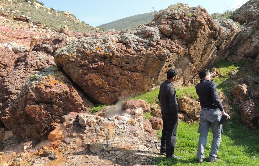
Tavlan and Gurcan

The NAF makes up a crustal scale fault zone aligning from the east of the Turkey towards the
NW Anatolia. The attitude of the fault activity in the peninsula splays, resulting in multiple fault
segments. It dominates the tectonic control in the region with maximum lateral stress in NW-SE
and minimum lateral stress in NE-SW. In the historical period, it caused major earthquakes
magnitude greater than 7.0.
The Bababurnu tectonic domain includes NW-SE oriented fault clusters in the SW of the
Peninsula and offshore. It accommodates two strike-slip fault segments in the north and south,
transferring the shearing through normal faults. The Tuzla fault zone in Bababurnu tectonic
domain is the largest structural feature of the Tuzla Geothermal Field (Figure 5).

Figure 5: Field photo showing a hot spring along an antithetic normal fault of the Tuzla fault zone in altered
 Late Tertiary volcano-sedimentary rocks

The Edremit Graben was formed following a pre-existing detachment fault similar to the graben
systems in the western Anatolia (Cavazza et al. 2009; Sozbilir et al. 2016). It is thought to have
oblique and strike-slip displacement as a result of NAF replacement.
A Riedel shear model (Riedel, 1929) can explain the structural control in the Biga Peninsula.
Assuming the NAF dominates the region with NW-SE maximum horizontal stress (σ1),
synthetic (R) and antithetic (R’) Reidel shears are expected to occur (Figure 4). The Kestanbol
fault is supposed to develop under the control of NAF, using the loose metasomatic zone
weakened due to hydrothermal alteration minerals on the western side of the Kestanbol Pluton. It
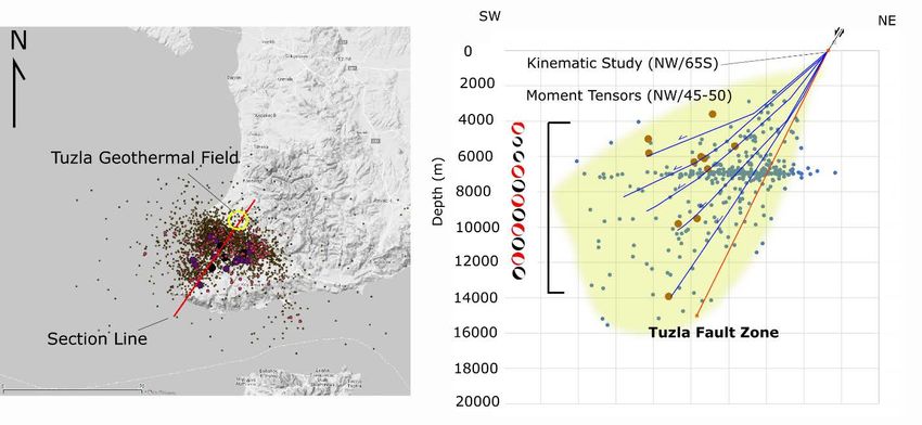
Tavlan and Gurcan

corresponds to a synthetic conjugate of the Reidel shear of the NAF. NW-SE faults in the
Bababurnu tectonic domain is on the other hand in conjunction with the NAF and correspond to
its antithetic shears (R’).

3.1 Tuzla Fault: Evidence From The Early 2017 Earthquake Swarm
Tuzla fault, a member of the Bababurnu tectonic domain, caused a series of earthquake swarm in
early 2017. More than 3,000 earthquakes peaking at magnitude 5.3 are recorded in nearly two
months. Moment tensors after these earthquakes pointed the Tuzla fault has a great depth (up to
15 km) with normal faulting displacement. The epicenters of earthquakes are focused in around
6 km below from the surface.
The former kinematic studies on the Tuzla fault suggested a steep fault plane dipping 65-70˚ to
the SW. However, the shared moment tensors have revealed the average dip is around 50˚. The
contrast between the kinematic analysis and the moment tensors could be explained by variance
of fault geometry by depth, such as a listric geometry. Plotting the scattered epicenters on a map
and focus on a NE-SW cross-section well demonstrates the geometry of the Tuzla fault, which
would correspond backwardly tilted multiple listric segments (Figure 6).

Figure 6: Scattered earthquake epicenters in map view (lest) and NE-SW cross-section demonstrating the
 geometry of the Tuzla fault (right). Moment tensors and earthquake data are received from
 www.deprem.gov.tr (AFAD).

3.2 Stress-Field Study And Slip-Dilation Tendency Estimation
A stress field is a region in a body for which the stress is defined at every point. It comprises the
terminology of the vertical stress (S1), minimum (S3) and maximum stress (S2). In order to
calculate slip and dilation tendency, the knowledge of stress field is required. Slip tendency (Ts,
equation 1) for faults is an approximation method to relatively compare their re-activation
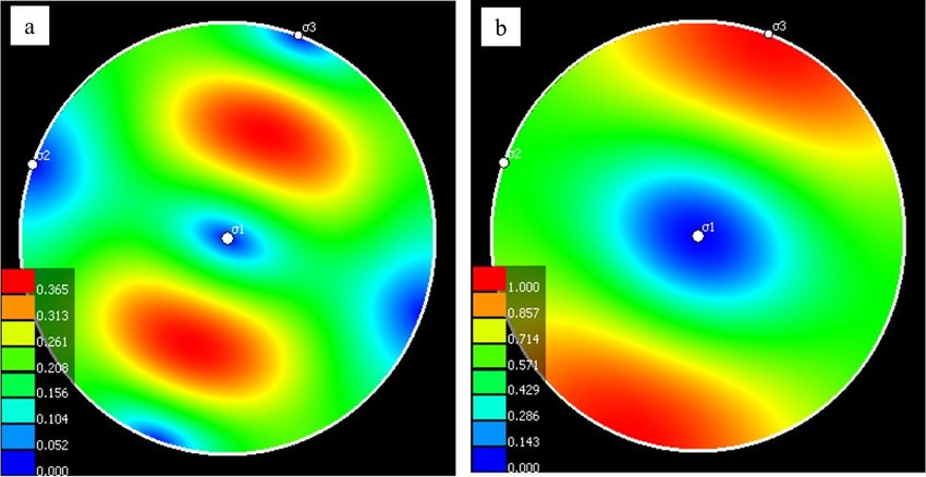
Tavlan and Gurcan

potential, while the dilation tendency (Td, equation 2) is a theoretical estimation of fluid
transitivity potential (Morris et al. 1996):

 σ 1 − σn
 Ts = (1)
 σ1 − σ 3
 τ
 Td = (2)
 σneff

where σ1 is maximum stress, σ3 is minimum stress, σn is normal stress, σneff is effective normal
stress and is the shear stress.
Both kinematic data and moment tensor solutions suggest stress magnitudes ranking as
Sv>Shmax>Shmin, indicating the normal faulting domain is prevailed in Tuzla. Based on the
same data, azimuth of the least (S3) and maximum (S1) horizontal stresses are found
approximately 20˚ and 110˚, respectively. The difference between magnitudes of Sv and the
Shmin, as well as their orientations are key factors in determination of slip and dilation tendency.
The slip tendency of a pre-existing fault is the highest when the dipping value is in between 40˚
and 70˚. Hence, the re-activation potential of a fault plane is the highest when the dipping values
are moderate (see red pole zone in Figure 7a).The dilation tendency gets higher in steeper planes
as they would be less impacted by the highest stress (Sv). Therefore, the highest dilation
potential is in vertical planes (see red pole zone in Figure 7b).

Figure 7. Stereonet projection shows a: slip tendency, b: dilation tendency. Calculated results for 1,600m
 below surface (hydrostatic case). Sv: 435.88 bar (density: 2.4 g/cc), Shmin: 250.22 bar (avg. 12.32 ppg
 leak-off test results), Shmax: 343.05 bar (constraining with normal faulting domain). Envisaged fault
 planes are shown as poles where they correspond to horizontal plane (dipping 0˚) at the center and to
 vertical plane (dipping 90˚) at the perimeter of the projection.
Tavlan and Gurcan

The calculated optimal azimuth and dipping values of a pre-existing fault in the Tuzla area are;
100-120˚/40-70˚ for slip tendency and 100-120˚/65-90˚ for dilation tendency, regardless of the
dip direction.

4. Reconstruction Of The Geothermal Conceptual Model
Tuzla, with its carbonate reservoir rock, clayish volcanic cover, metamorphic and magmatic
basement and faults allowing deep fluid circulation, is an example of a proper geothermal
system. Studies to date confirmed the lithostratigraphy and determined the surface trails of the
geologic structures related to the geothermal fluid transfer based on the locations clay alterations
and hot springs.
Even though E–W, ENE–WSW and NNE–SSW oriented main and subordinate faults are in the
area, individual faults in a 20km wide NW–SE trending en-echelon fault zone are found cross-
cutting these main and subordinate structures. The Tuzla fault, one of the largest NW-SE faults
with a SW dipping fault plane of 70˚ on the surface is thought to be the axis of the upflow zone.
Two power plants (shallow (
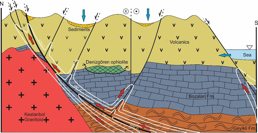
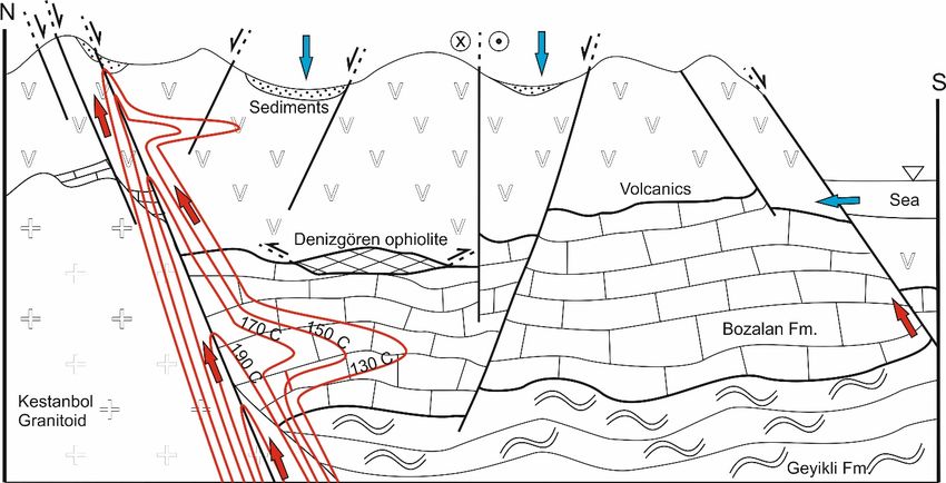
Tavlan and Gurcan

discover reservoirs much warmer than that developers currently exploit. Seismic surveys might
further constrain the estimated depths to reach the target upflow zone.

Figure 8. Old conceptual model of the Tuzla Geothermal Field. Red curves: isotherms; red arrows: hot water
 flow direction; blue arrows: cold water flow direction. This figure is not drawn to scale but overall
 width and depth are about 15km and 5km respectively.

Figure 9. Conceptual model of Tuzla reconstructed after recent earthquake data. White curves: isotherms;
 red arrows: hot water flow direction; blue arrows: cold water flow direction. This figure is not drawn
 to scale but overall width and depth are about 15km and 5km respectively.
Tavlan and Gurcan

Furthermore, Bababurnu fault seems to hold the similar potential to Tuzla fault. A few seasonal
hot springs are along the fault but many occur on the sea floor since the fault bounds the land and
the sea and the hanging block of the fault is mostly located in off-shore. Yet still some buried
fertile upflow zones might be found in close vicinity to the fault or its related structures.

5. Conclusion
Although the two largest grabens are the major drivers of the Turkish geothermal industry, there
are other fields in Turkey (e.g. Biga Peninsula, Cappadocia) with untapped potential.
Tuzla Geothermal Field displays essential conceptual features of a geothermal system: heat
source, permeable reservoir rock, cover rock, meteoric feed, etc. Supported by the stress-field
analysis, deep fluid circulation in Tuzla system is focused along the Tuzla master fault, an active
normal fault linked to NAF. The geometry of this fault appears to be listric by the early 2017
earthquake activity.
Reconstruction of the geothermal conceptual model turn out to be necessary after recent
evidence gathered from earthquake. The biggest change in new model is the dipping angle and
geometry of Tuzla fault. The fluid flow along Tuzla fault is interpreted as not steep, but dipping
progressively less steeply towards the south-- suggesting a wider area to select drill sites which
might reach the heart of the upflow zone. Additionally, other related faults in the Bababurnu
tectonic domain (i.e. Bababurnu fault) may hold a similar potential.

ACKNOWLEDGMENTS

The authors thank Wouter van Leeuwen and William Cumming, this manuscript was greatly
improved by their comments. Some of the parts of this study were made possible by the support
of Transmark Renewables.

REFERENCES

AFAD: Republic of Turkey Prime Ministry, Disaster and Emergency Management Presidency,
 "Earthquake Catalog." www.deprem.gov.tr
Altunkaynak, S., and Genc, S.C. "Petrogenesis and time-progressive evolution of the Cenozoic
 continental volcanism in the Biga Peninsula, NW Anatolia (Turkey)." Lithos, 102, (2008),
 316–340.
Baba, A., Ates, O., and Deniz, O. "The Environmental and Hydrogeochemical Properties of the
 Tuzla-Kestanbol-Hidirlar Geothermal Sources, Turkey." UNU GTP 30th Anniversary
 Workshop, Rejykavik, Iceland, (2008), pp.1-10.
Baba, A., Yuce, G., Deniz, O., and Ugurluoglu, Y.D. "Hydrochemical and isotopic composition
 of Tuzla Geothermal (Canakkale‐Turkey) Field and its environmental impacts."
 Environmental Forensics, 2, (2009), 144-161.
Barka, A.A. "The North Anatolian Fault." Annales Tectonicae, 6, (1992), 164-195.
Tavlan and Gurcan

Beccaletto, L. "Geology, correlations and geodynamic evolution of the Biga Peninsula
 Northwest Turkey." PhD Thesis, University of Lausanne, (2004), 194 p.
Beccaletto, L., and Jenny, C. "Geology and correlation of the Ezine zone: A Rhodope fragment
 in NW Turkey?" Turkish Journal of Earth Sciences, 13, (2004), 145–176.
Cavazza, W., Okay, A.I., and Zattin, M. "Rapid early-middle Miocene exhumation of the
 Kazdag Massif (western Anatolia)." Int. J. Earth Sci., 98, (2009), 1935–1947.
Morris, A., Ferrill, D.A., and Henderson, D.B. "Slip tendency analysis and fault reactivation."
 Geology, 24, (1996), 275-278.
MTA: General Directorate of Mineral Research and Exploration & ITU (Istanbul Technical
 University) Mining Faculty. "General and Economic Geology of Biga Peninsula (Turkish)."
 MTA Special Publication Series, 28, Ankara, (2012), ISNB: 978-605-5310-18-9.
Okay, A.I. "Geology of Turkey: A synopsis." Anschnitt, 21, (2008), 19-42.
Okay, A.I., Siyako, M., and Burkan, K. A. "Geology and tectonic evolution of the Biga
 Peninsula." Special issue on tectonics. J. F. Dewey (Ed.), Bulletin of the Technical University
 of Istanbul, 44, (1991), 191–255.
Okay, A.I., Satir, M., Maluski, H., Siyako, M., Monie, P., Metzger, R., and Akyuz S. "Paleo- and
 Neo-Tethyan events in northwest Turkey: geological and geochronological constraints in
 Tectonics of Asia" (ed. A. Yin & M. Harrison), Cambridge University Press, (1996), 420-
 441.
Republic of Turkey Energy Market Regulatory Authority. http://www.emra.org.tr
Riedel, W., "Zur Mechanik Geologischer Brucherscheinungen." Zentral-blatt fur Mineralogie,
 Geologie und Paleontologie B, (1929), 354–368.
Robertson, A.H.F., and Grasso, M. "Overview of the Late Tertiary-Recent tectonic and palaeo-
 environmental development of the Mediterranean region." Terra Nova, 7, (1995), 114–127.
Sengor, A.M.C., Gorur, N., and Saroglu, F. "Strike-slip faulting and related basin formation in
 zones of tectonic escape: Turkey as a case study." In: K.D. Biddle & N. Christie-Blick (eds.),
 Strike-slip deformation, basin formation and sedimentation, Society of Economic
 Paleontologists and Mineralogist, Special Publication, 17, (1985), 227-264.
Sengor, A.M.C., Tuysuz, O., Imren, C., Sakinc, M., Eyidogan, H., Gorur, N., Le Pichon, X., and
 Rangin, C. "The North Anatolian Fault: a new look." Annual Review of Earth and Planetary
 Sciences, 33, (2005) 37-112.
Sozbilir, H., Sumer, O., Ozkaymak, C., Uzel, B., Guler. T., and Eski. S. "Kinematic analysis and
 palaeoseismology of the Edremit Fault Zone: evidence for past earthquakes in the southern
 branch of the North Anatolian Fault Zone, Biga Peninsula, NW Turkey." Geodimaica Acta,
 28, 4, (2016), 273-294.
Wessel, P., and Muller, R. D. "Plate Tectonics." Treatise of Geophysics, 2(6), (2015), 45-93.
Yaltirak, C., Isler, E.B., Aksu, A.E., and Hiscott, R.N. "Evolution of the Bababurnu Basin and
 shelf of the Biga Peninsula: Western extension of the middle strand of the North Anatolian
 Fault Zone, Northeast Aegean Sea, Turkey." J. Asian Earth Sci., 57, (2012), 103–119.
 doi:10.1016/j.jseaes.2012.06.016
Tavlan and Gurcan

Yilmaz, Y. "New evidence and model on the evolution of the southeast Anatolian orogen."
 Geological Society of America Bulletin, 105, (1993), 252-271.
You can also read