Pleistocene Glaciers of the Eldorado Forest and How to Read Them - ENFIA
←
→
Page content transcription
If your browser does not render page correctly, please read the page content below
Pleistocene Glaciers of the Eldorado Forest and How to Read Them
by Lester Lubetkin
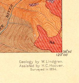
Recently, I was looking through the 1896 geologic map and folio for the Pyramid Peak
Quadrangle and I came across one of the most comprehensive and complete
descriptions of the glacial history of the Eldorado National Forest
that I have seen. This work was written by Waldmer Lindgren,
who was a geologist with the US Geological Survey studying and
mapping the geology of the Sierra Nevada. His studies led him to
write a detailed report of the “Auriferous Gravels of the Sierra
Nevada”; a seminal work that is still used extensively today. (If
you are interested in learning about the ancient river system of
the Sierra Nevada, active some 50 million years ago, this is the
book for you.)
In the late 1880’s and early 1890’s, when Lindgren was mapping
the geology of the Sierra Nevada, one of his field assistants was
none other than Herbert Hoover, future US president. Hoover was
a student of geology at Stanford University at the time and was hired by the US
Geolgocial Survey as a field assistant in the
summers, working under Lindgren. Hoover
described in his memoir that much of the field work
was done on horseback. In the legend for the
geologic map in the Pyramid Peak folio, we find
Hoover listed as Lindgren’s field assistant in 1894.
And it was here that he gained the early
experieince that allowed him to go on to become a
well-respected mining geologist.
But, back to the glacial history of the Eldorado
National Forest. Rather than trying to summarize
Lindgren’s narrative, I’d like to give you his own
words, with some maps, annotations and other
info to help locate yourself and understand some
of the terms.
The Pleistocene
period is a geologic
time period
spanning from 2.6
million years ago to
11,700 years ago;
also known as the
Ice Age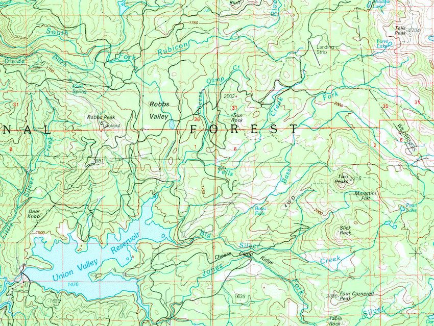
névé: granular
snow
accumulated on
high mountains
and
subsequently
compacted into
glacial ice.
Devils Basin: This
is the name of the
valley that now
contains Lake
Aloha (which was a
cluster of small
lakes and ponds
known as Medley
Lakes at the time).
The other name for
this basin located
in what is now
Desolation
Wilderness was
‘Desolation Valley’.

moraines: masses
of rocks and
sediment carried
down and
deposited by a
glacier, typically
forming ridges at
the glacier’s edges.

cirque: a half-open
steep-sided hollow
at the head of a
valley or on a
mountainside,
formed by glacial
erosion. Often
there is a lake at
the base of the
bowl carved by the
glacier.
As shown in the
                                                                            map below, the
                                                                            glacier filling the
                                                                            Rubicon Valley is
                                                                            now known to have
                                                                            flowed down the
                                                                            Rubicon River
                                                                            canyon and had it’s
                                                                            terminus just above
                                                                            where the South
                                                                            Fork Rubicon River
                                                                            meets the main
                                                                            Rubicon River.

                                               Upper
            Rubicon River                     Rubicon
                                               Valley
                                 1
                                                            Echo Summit

         South Fork American River
                                                 2

Map showing the extent of the latest major glaciation within the northern portion of the
Eldorado National Forest and adjacent areas. Light blue area is the area covered by glacial ice.
Yellow, pink and buff are to display elevation. Notice that Echo Summit was free of glacial ice.
The red arrows show the direction that glaciers flowed. One glacier flowed west and
terminated at the east end of Union Valley (1). Another glacier flowed south down Pyramid
Creek/Horsetail Falls (2) to near Strawberry. Modified from Ehlers and Gibbard, 2003.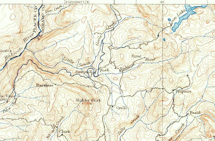
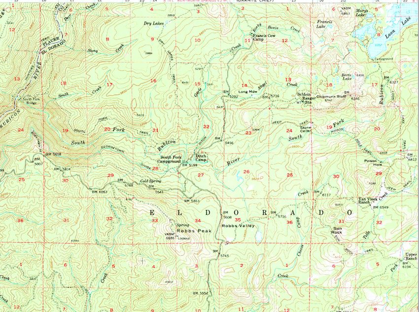
A portion of the 1889 Pyramid Peak topographic map, showing the location of Forni and
Filipini.

                                                        Forni

                                                                           Filipini

A Portion of the 1952 Robbs Peak topographic map, with the locations of Forni and Filipini
added. The original Forni Ranch is near what is now known as Stone Cellar and the Filipini
Ranch is near what is now known as the Van Vleck Ranch.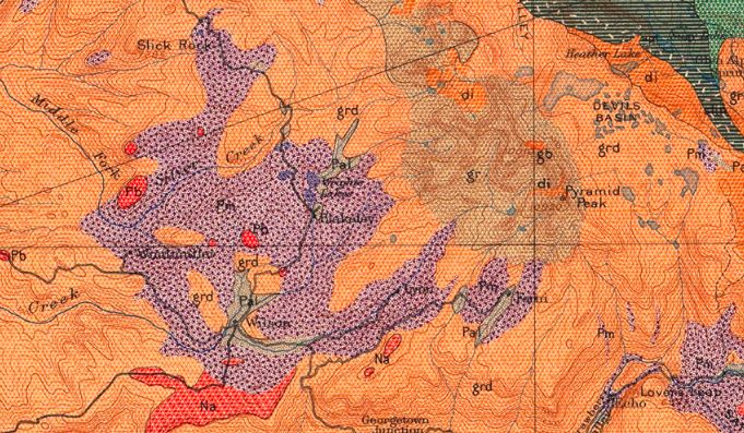
The North
              Fork Silver
              Creek is now
              known as
              Bassi Creek
              or Bassi Fork
              of Silver
              Creek.

              Bassi’s Ranch
              is now shown
              on
              topographic
              maps as
              Upper Bassi
              and is a little
              over 2 miles
              upstream
              from Bassi
              Falls.

               Union Valley
               is now
               flooded and
               submerged
               beneath
              Union Valley
          Reservoir. The
          glacier map
          above
          shows the extent
          of the glacier into
          Union Valley.
Bassi’s
          A portion of the
          1976 Placerville
          topographic map
          showing Union
          Valley Reservoir
          flooding Union
          Valley, the
          location of
          Bassi’s Ranch
          and Bassi Fork of
          Silver Creek.
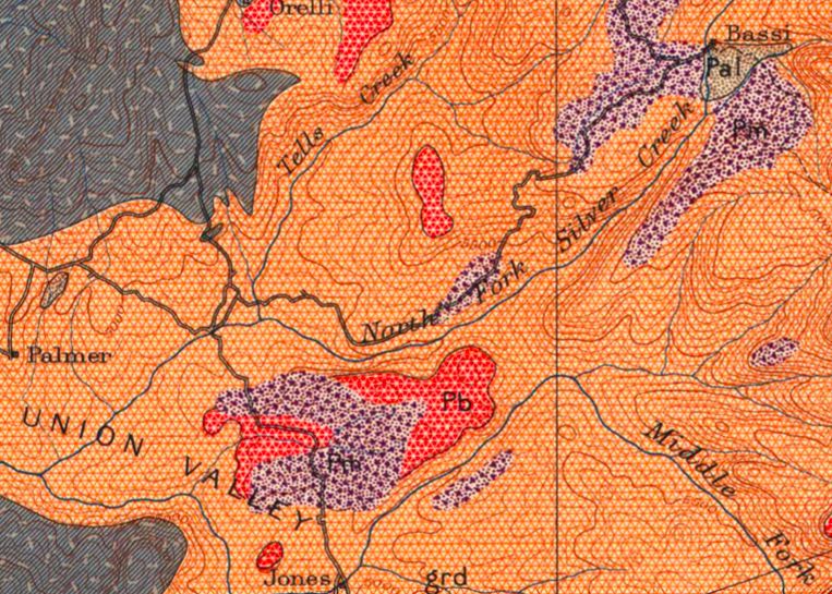
A portion of the 1896 geologic map of the Pyramid Peak Quadrangle showing the area near
Union Valley and the North Fork Silver Creek, now known as Bassi Creek or Bassi Fork of Silver
Creek. The red hatchured areas, labeled Pb are areas of Pleistocene basalt. The purple
hatchured areas labeled Pm are glacially deposited moraines of Pleistocene age. Lindgren’s
text (above) mentions that the rocks in the low gap just east of the basalt shown south of North
Fork Silver Creek “bear every evidence of having been worn by ice”.
Wilson’s Ranch is the
                                                                         large open meadow
                                                                         along the west side
                                                                         of the Wright’s Lake
                                                                         Rd between where it
                                                                         crosses Lyon’s Creek
                                                                         and the intersection
                                                                         with the Wright’s Tie
                                                                         Rd (coming from Ice
                                                                         House Reservoir).
                                                                         Windmuller’s Ranch
                                                                         is along the Wright’s
                                                                         Tie Rd.

A portion of the 1896 geologic map, showing the large deposits of glacially derived material
between Wright’s Lake and Wilson Meadow. The South Fork of Silver Creek is the stream
flowing westward through Wilson Meadow. The valley fill areas colored in grey and labeled Pal
are Pleistocene alluvium. The extensive areas colored in orange and labeled grd are areas
underlain by the granodioite bedrock that makes up the core of the Sierra Nevada.
Forni’s meadow is now refered to as Upper Forni and can be seen on the geologic map on the previous page. Strawberry Creek flows into the South Fork Ameriacn River at the western end of Strawberry Valley (west of Strawberry). Echo is now refered to as Strawberry. And Devils Basin is the area now filled by Lake Aloha in Desolation Wilderness.
glacial
  sapping: the
  plucking or
  quarrying of
  blocks of rock
  at the head
  and base of a
  glacier,
  leading to the
  creation of
  steep
  headwalls. A
  popular
  theory at the
  time, but the
  term is not
  used
  commonly
  any longer.

 Devils Basin
 glacier: This is
 describing the
 glacial
 features at
 Pyramid
 Creek and
 Twin Bridges.
 The “double
 lateral
 moraine”
 mentioned is
 the large
 moraine that
 Highway 50
 traverses,
 east of
 Pyramid
 Creek. Note
 the early
 recognition of
 at least 2
 glacial
 periods in the
 Sierra
Nevada.
This section
                                                                   is describing
                                                                   the large flat
                                                                   where Camp
                                                                   Sacramento
                                                                   is now
                                                                   located. This
                                                                   was a lake
                                                                   dammed by
                                                                   the Pyramid
                                                                   Creek glacier
                                                                   some 15,000
                                                                   years ago.

                                                                   Bryan’s
                                                                   Ranch is
                                                                   located at
                                                                   what is now
                                                                   known as
                                                                   Bryan
                                                                   Meadow, at
                                                                   the head of
                                                                   Bryan Creek
                                                                   (a tributary of
                                                                   Sayles
                                                                   Creek). The
                                                                   canyon
                                                                   Lindgren is
                                                                   referring to is
                                                                   Huckleberry
                                                                   Canyon,
                                                                   which opens
                                                                   northward
                                                                   and extends
                                                                   to near
                                                                   Highway 50.
                                                                   As described,
                                                                   another
                                                                   glacier flowed
                                                                   down to Lake
                                                                   Audrain
leaving a well formed moraine on the north side of Lake Audrain.
The “junction of the main branches” is referring to the confluence of Silver Fork of the American River and North Tragedy Creek. This is also where the Silver Fork Road crosses Fitch-Rantz Bridge and leaves the river canyon. The “dam” mentioned is an early dam at the location of Lower Bear River Reservoir. Cold Creek is a south flowing stream on the north and west side of Mokelumne Peak, now known as Cole Creek. It’s location was mismapped in the 1889 topo map - the glacier did not reach the Mokelumne River. Summit Creek is now known as Summit City Creek. As shown in the map below, currently the glaciers did extend well past the
junction with the North
                                                                         Fork Mokelumne River,
                                                                         joined with the main
                                                                         ice mass and
                                                                         terminated a little
                                                                         below the location of
                                                                         Salt Springs Reservoir.

                                                                   Woodford

                                    3
                                               2
                                                    Summit
                                                   City Cyn
                        Bear
                        River
                                           1

                         Mokelumne
                           River

Map showing the extent of the latest major glaciation within the southern portion of the
Eldorado National Forest and adjacent areas. Light blue area is the area covered by glacial ice.
Yellow, pink and buff are to display elevation. Notice that Mokelumne Peak (1) and the Round
Top/Thimble Peak Ridgeline extended above the glaciers. The red arrows show the direction
that glaciers flowed. A glacier that flowed down Caples Creek (3) had one arm that flowed
northward through the saddle and down Strawberry Canyon. Modified from Ehlers and
Gibbard, 2003.
In this section, Lindgren is describing a much older glacial event, likely about 800,000 years ago. The glacial deposits are found on the ridge tops on the north and south sides of the Rubicon Canyon, near where the 11 Pines Road enters the Rubicon Canyon on the north and south sides, but glacial deposits are not found in the canyon bottom here. At that time, the Rubicon Canyon was not as deep as today and so had not been affected by this older glacier. Evidence of this much earlier glacial period is not well preserved, and so the fact that Lindgren did not observe evidence in other places does not preclude the fact that there were other glacial events during the Pleistocene.
While much of this next section does not describe glaciers within the Eldorado Forest, it does
help to explain the landscape and glacial deposits immediately east of the Forest and around
Lake Tahoe.

                                                                              Terminal
                                                                              moraines are the
                                                                              glacially
                                                                              deposited ridges
                                                                              that mark the
                                                                              farthest extent of
                                                                              the glacier. The
                                                                              text refers to “at
                                                                              least six”,
                                                                              however, these
                                                                              moraines
                                                                              recording the
                                                                              glacier’s retreat
                                                                              are now called
                                                                              “recessional
                                                                              moraines”.
This little lake can be seen below Highway 50 as you drive from Echo Summit towards Meyers. Half Moon Lake is located in Desolation Wilderness, west of Mt. Tallac and at the eastern base of Jack’s Peak and Dick’s Peak. Lateral moraines are moraines that are deposited along the sides of a glacier, in contrast to terminal moraines which for at the downslope end of a glacier.
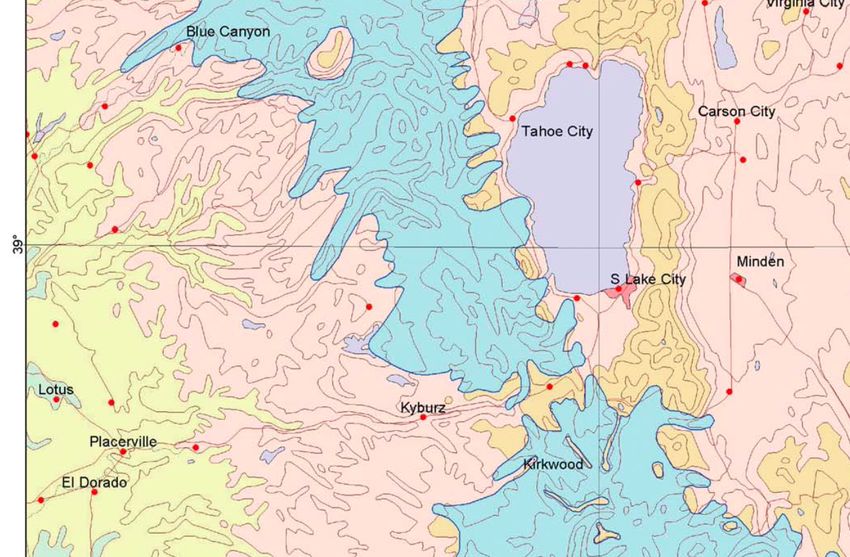
Map showing the extent of
                                       glaciers in the northern part of the
                                       Eldorado Forest, Desolation
                                       Wilderness and Lake Tahoe,
                                       during the last major glacial
                                       period. Light blue area marks the
                                       extent of the ice cap. The red
                Emerald Bay/           arrows show the direction of ice
                Cascade Lake
                                       flow. Modified from Ehlers and
Upper Rubicon
   Valley                              Gibbard, 2003.
                    Fallen Leaf Lake

                        Echo Summit
A medial moraine
is a glacially
deposited
moraine that
forms where 2
glaciers merge
and flow together.
Highway 89 along
the west side of
Lake Tahoe
traverses the crest
of this medial
moraine.
For those that would like to see the orignial Pyramid Peak Folio or read more of Lindgren’s
description of the geology of this amazing area, as the geology was understood in the 1890’s,
here is a link to the document: https://pubs.er.usgs.gov/publication/gf31You can also read


